c.11 land use and planning - california public … land... · in order to determine impacts to land...
TRANSCRIPT

Valley South Subtransmission Project C.11 LAND USE AND PLANNING
Draft EIR C.11-1 January 2016
C.11 Land Use and Planning
Introduction
This section describes effects associated with land use and planning that would be caused by
implementation of the VSSP. The following discussion addresses existing environmental conditions in
the affected area, identifies and analyzes environmental impacts for the proposed Project, and
recommends measures to reduce or avoid significant impacts anticipated from Project construction,
operation, and maintenance. In addition, existing laws and regulations relevant to land use and planning
are described. In some cases, compliance with these existing laws and regulations would serve to reduce
or avoid certain impacts that might otherwise occur with the implementation of the proposed Project.
Scoping Issues Addressed
During the scoping period for the EIR (May 5 through June 8, 2015), written comments were received
from agencies, organizations, and the public. These comments identified various substantive issues and
concerns relevant to the EIR analysis. No issues related to land use and planning were raised during
scoping.
C.11.1 Environmental Setting
The identification of existing land uses was based upon existing land use geographic information
systems (GIS) data (Google Earth, 2015), city and county data on land use designations and zoning (see
Table C.11-1), and field reconnaissance conducted in February 2013.
The proposed Project is located within incorporated jurisdictions and unincorporated areas of Riverside
County. Components of the Project would be staged or constructed within the cities of Menifee,
Murrieta, Temecula, and Perris, as well as unincorporated County communities. For the purposes of this
analysis, the Land Use Study Area includes the following Project components:
Segment 1: This segment involves constructing a new 12-mile 115-kV subtransmission line across the
following jurisdictions: City of Menifee, City of Murrieta, and unincorporated Riverside County. Segment 1
would be located within existing SCE easements, fee-owned property, and public franchise areas as well
as new ROW (see Section B.3.5). Some new easements and permits may be acquired to accommodate
Project facilities (SCE, 2014).
Segment 2: This segment involves reconductoring a section of the existing Valley-Ault-Triton 115-kV
subtransmission line across the following jurisdictions: City of Temecula and unincorporated Riverside
County. Segment 2 would occur within existing SCE easements (SCE, 2014).
Material Staging Yards: While the Project may require only two material staging yards, six potential
staging yard locations have been identified. The potential staging yards are located in the following
jurisdictions: City of Menifee, City of Perris, and unincorporated Riverside County.
In order to determine impacts to land use and planning (see Section C.11.4), this analysis has identified
sensitive receptors within the Study Area. A sensitive receptor is a person in the population who is
particularly susceptible to health effects due to exposure to contaminants and other hazards. Sensitive
land uses where sensitive receptors are typically located include schools, day care facilities, playgrounds,
churches, residences, and hospitals. Table C.11-1 summarizes the sensitive land uses that have been
identified along the proposed Project route.

Valley South Subtransmission Project C.11 LAND USE AND PLANNING
January 2016 C.11-2 Draft EIR
Table C.11-1. Sensitive Land Uses along Project Route Jurisdiction Land Use or Sensitive Receptor Location Distance
from Project ROW
Segment 1 City of Menifee Romoland Elementary School North of CA-74 and east of
Antelope Rd. 0.9 mile Existing
Motte Field Park North of CA-74 and east of Antelope Rd.
0.9 mile Existing
Eller Park North of CA-74 and east of Antelope Rd.
0.8 mile Existing
Residences South of Matthews Rd. and east of Menifee Rd.
0.3 mile Existing
Heritage High School North of Matthews Rd. and west of Briggs Rd.
0.08 mile Existing
Marion V. Ashley Community Center
North of CA-74 and west of Briggs Rd.
0.7 mile Existing
Harvest Valley Elementary School North of CA-74 and west of Briggs Rd.
0.9 mile Existing
Boulder Ridge Middle School South of Matthews Rd. and west of Menifee Rd.
0.8 mile Existing
Mesa View Elementary School South of Matthews Rd. and east of Menifee Rd.
0.6 mile Existing
Ethan A. Chase Middle School South of McCall Blvd. and east of Menifee Rd.
0.6 mile Existing
Heritage Park North of McCall Blvd. and east of Menifee Rd.
0.6 mile Existing
Residences South of Matthews Rd. and west of Briggs Rd.
0.5 mile Existing
Unincorporated Riverside County
Highland Palm Golf Course South of CA-74 and east of Briggs Rd.
0.5 mile Existing
Residences South of McLaughlin Rd. and east of Briggs Rd.
Less than 0.01 mile
Existing
Residences North and south of Matthews Rd. and east of Briggs Rd.
0.03 mile to 0.5 mile
Existing
Double Butte County Park North of Grand Ave., between Double Butte West and Double Butte East
Less than 0.01 mile
Existing
Residences North and south of Simpson Rd., and east of Leon Rd.
0.01 mile New
Residences South of Domenigoni Pkwy and east and west of Leon Rd.
0.01 mile to 0.5 mile
New
Pines Airpark North of Scott Rd. and east of Leon Rd.
0.5 mile New
City of Menifee Residences South of Scott Rd. and west of Leon Rd.
0.01mile Existing
Unincorporated Riverside County
Residences South of Scott Rd. and east of Leon Rd.
0.01 mile Existing
Residences North and south of Jean Nicholas Rd./Baxter Rd., and east and west of Leon Rd.
0.01 mile Existing
Blessed Teresa of Calcultta Northwest of CA-79 and east of Elliott Rd.
0.6 mile Existing
Dorothy McElhinney Middle School Southwest of Briggs Rd. and northwest of Leon Rd.
0.8 mile Existing
Lisa J. Mails Elementary School Southwest of Briggs Rd. and northwest of Leon Rd.
0.6 mile Existing
Kona Park Southwest of Jean Nicholas Rd. 0.4 mile Existing

Valley South Subtransmission Project C.11 LAND USE AND PLANNING
Draft EIR C.11-3 January 2016
Table C.11-1. Sensitive Land Uses along Project Route Jurisdiction Land Use or Sensitive Receptor Location Distance
from Project ROW
and east of Leon Rd. Leon Park South of Jean Nicholas Rd. and
east of Leon Rd. 0.02 mile Existing
Spencer’s Crossing Park Northwest of Leon Rd. and west of Briggs Rd.
0.3 mile Existing
Primrose Park Southeast of CA-79 and south of Skyview Rd.
0.6 mile Existing
Emerald Park Southeast of CA-79 and south of Skyview Rd.
0.7 mile Existing
Susan La Vorgna Elementary School
Southeast of CA-79 and south of Skyview Rd.
0.8 mile Existing
Residences North and south of Thompson Rd. and east of CA-79
0.06 mile Existing
Sheffield Park South of Thompson Rd. and west of Pourroy Rd.
0.8 mile Existing
Retail/ Commercial Southeast of Winchester Rd. and north of Benton Rd.
0.1 mile Existing
Segment 2 Unincorporated Riverside County
Retail/ Commercial Southeast of Winchester Rd. and south of Benton Rd.
0.2 mile Existing
Ten27 Church Southeast of Winchester Rd. and south of Benton Rd.
0.2 mile Existing
French Valley University Preschool South of Benton Rd. and east of Van Gaale Ln.
0.2 mile Existing
Riverside County Sheriff/ Riverside County Southwest Juvenile Hall
South of Auld Rd. and west of Leon Rd.
0.04 mile Existing
Residences South of Auld Rd. and east of Leon Rd.
0.01 mile Existing
French Valley Airport South of Auld Rd. and east of CA-79
0.4 mile Existing
Crown Valley Park South of Auld Rd. and west of Pourroy Rd.
0.7 mile Existing
Residences North of Murrieta Hot Springs, and east of west of Leon Rd.
Less than 0.05 mile
Existing
Alamos Elementary School North of Promontory Pkwy and east of Leon Rd.
0.4 mile Existing
Bella Vista Middle School North of Browning St. and east of Pourroy Rd.
0.7 mile Existing
French Valley Community Center and Park
South of Browning St. and east of Pourroy Rd.
0.8 mile Existing
Faith Bible Church South of Browning St. and east of Pourroy Rd.
0.8 mile Existing
The Rock Church of Temecula Valley
North of Murrieta Hot Springs Rd. and east of CA-79
0.9 mile Existing
Church of Jesus Christ of Latter-day Saints
North of Murrieta Hot Springs Rd. and east of CA-79
0.9 mile Existing
Nicolas Valley Elementary School South of Murrieta Hot Springs Rd. and east of N. General Kearny Rd.
0.3 mile Existing
Nakayama Park North of Nicolas Rd. and west of Joseph Rd.
0.3 mile Existing
City of Temecula Residences South of Murrieta Hot Springs Rd., and east and west of Project
Less than 0.05 mile
Existing
Calvary Baptist Church and Grace Presbyterian Church
South of Nicolas Rd. and west of Calle Medusa
0.2 mile Existing

Valley South Subtransmission Project C.11 LAND USE AND PLANNING
January 2016 C.11-4 Draft EIR
Table C.11-1. Sensitive Land Uses along Project Route Jurisdiction Land Use or Sensitive Receptor Location Distance
from Project ROW
Riverton Park South of Calle Girasol and northwest of Riverton Ln.
0.5 mile Existing
Voorburg Park North of Nicolas Rd. and east of N. General Kearny Rd.
0.9 mile Existing
Nicolas Road Park North of Nicolas Rd. and west of N. General Kearny Rd.
0.9 mile Existing
Material Staging Yard 1 City of Menifee Residences South of Matthews Rd. and east
of Menifee Rd. 0.2 mile NA
Material Staging Yard 2 Unincorporated Riverside County
French Valley University Preschool South of Benton Rd. and east of Van Gaale Ln.
0.1 mile NA
Residences North and south of Benton Rd., and east and west of Van Gaale Ln.
0.01 NA
Material Staging Yard 3 City of Perris Residences North of Ellis Ave. and west of
Goetz Rd. 0.2 mile NA
Material Staging Yard 4 City of Menifee Residences North and south of Ethanac Rd.,
and west of Antelope Rd. Less than 0.05 mile
NA
Eller Park North of CA-74 and east of Antelope Rd.
0.07 mile NA
Romoland Elementary School North of CA-74 and east of Antelope Rd.
0.1 mile NA
Material Staging Yard 5 City of Menifee Residences North of CA-74, and east and
west of Menifee Rd. 0.1 mile NA
Material Staging Yard 6 City of Menifee Residences North of CA-74, and east and
west of Menifee Rd. 0.1 mile NA
Sources: Google Earth, 2015; SCE, 2014. Note: NA- Not Applicable
C.11.2 Regulatory Framework
C.11.2.1 Federal
Federal Aviation Administration
As discussed in Section B.3.1.2, the Federal Aviation Administration (FAA) is responsible for aviation
safety and air traffic control. Federal Regulation Title 14 Part 77 establishes standards and notification
requirements for objects affecting navigable airspace, including structures taller than 200 feet or certain
structures located within 20,000 feet (approximately 3.8 miles) of an airport. If structures exceed the
regulatory thresholds, the FAA requires notification (i.e., FAA Form 7460-1: Notice of Proposed
Construction or Alteration). Depending on the determination, the FAA may request redesigning
structure heights, marking structures, incorporating aviation lighting, or placing marker balls on wire
spans.
C.11.2.2 State
No State regulations specific to land use and planning would apply to the proposed Project. As discussed
in Section A.3 (Permits and Approvals) and throughout the applicable impact analyses (Section C.5

Valley South Subtransmission Project C.11 LAND USE AND PLANNING
Draft EIR C.11-5 January 2016
Biological Resources, Section C.10 Hydrology and Water Quality, and Section C.14 Transportation and
Traffic), if the proposed Project is approved by the CPUC, SCE would be required to obtain required
permits/approvals from State agencies (see Table A-1 in the Introduction).
C.11.2.3 Local
The CPUC regulates and authorizes the construction of investor-owned public utility facilities, and
therefore the CPUC has jurisdiction over the siting and design of the proposed Project. Investor-owned
public utility projects, such as the VSSP, are exempt from local land use and zoning regulations and
permitting in accordance with General Order No. 131-D. This exemption is applicable to all components
of the proposed Project. However, Section XIV.B requires “public utilities shall consult with local
agencies regarding land-use matters.” Although Section XIV.B does not require the CPUC to evaluate
consistency with local land use policies, the CPUC has taken into consideration local agency policies in
the preparation of this EIR.
The Project would be located within Riverside County and the cities of Perris, Menifee, Murrieta, and
Temecula (north to south). A discussion of the applicable plans in these cities is presented below. The
impact discussion in Section C.11.4 (Environmental Impacts and Mitigation Measures) includes a
description and list of the applicable visual resource and land use policies from these jurisdictions.
County of Riverside
The County of Riverside General Plan, as amended, is two-tiered: (1) General Plan Elements cover the
entire unincorporated area of the County and provide management direction for the overall pattern of
development within the County; (2) 19 Area Plans provide more detailed land use designations for
specific planning areas. Further planning guidance is also provided through specific plans that establish
design guidelines for a particular community.
County of Riverside General Plan included relevant goals and policies and specific plan design guidelines.
The following County plans do not have policies relevant to the proposed Project:
Dutch Village Specific Plan (County of Riverside, 2015)
Rancho Bella Vista Specific Plan (County of Riverside, 2012)
Menifee North Specific Plan (County of Riverside, 2015)
Quinta Do Lago Specific Plan (County of Riverside, 2015)
Winchester Hills Specific Plan (County of Riverside, 2015)
Menifee Valley Ranch Specific Plan (County of Riverside, 2015)
French Valley Specific Plan (County of Riverside, 2015)
City of Menifee
The City of Menifee General Plan Land Use Element addresses infrastructure and utility issues associated
with existing and future development (City of Menifee, 2013a). Segment 1 of the proposed Project
would traverse the Menifee Valley Ranch Specific Plan area. Specific plans within the City of Menifee
provide customized zoning for a particular area, and the Menifee Valley Ranch Specific Plan establishes
zoning for the existing and future residential development in the Heritage Lakes community (City of
Menifee, 2013b).

Valley South Subtransmission Project C.11 LAND USE AND PLANNING
January 2016 C.11-6 Draft EIR
General Plan includes land use goals and policies applicable to electric utility projects, which are
presented in the impact analysis below (Section C.11.4). The Menifee Valley Ranch Specific Plan does
not contain policies relevant to the proposed Project (City of Menifee, 2013a).
City of Murrieta
The City of Murrieta General Plan Land Use Element serves as the city’s primary guidance for future
development and redevelopment of the city (City of Murrieta, 2011). The City’s General Plan includes
land use goals and policies specific to electric utility projects, which are presented in the impact analysis
below (Section C.11.4).
City of Perris
The City of Perris is divided into 10 planning areas (i.e., Specific Plan Areas) for the purpose of identifying
opportunities and constraints and for establishing development guidelines. The proposed Material
Staging Yard 3 would be located in Planning Area 6 (Downtown Specific Plan Area) (City of Perris, 2005).
The Downtown Specific Plan was adopted in 1993 and updated in 2012 with the objective of preserving
the Downtown area, allowing greater mixed use and housing development, and expanding public spaces
(City of Perris, 2012). The City of Perris General Plan and the Downtown Specific Plan do not contain any
specific land use goals or policies relevant to electric utility projects (City of Perris, 2005 and 2012).
City of Temecula
The City of Temecula General Plan was created in 1993 and updated in 2005 to provide long-term policy
guidance for the city’s physical, economic, social and environmental changes. The Land Use Element
determines the future location, type, and intensity of new development and reuse projects (City of
Temecula, 2005a). Segment 2 of the proposed Project would traverse the Roripaugh Ranch Specific Plan
area. The Roripaugh Ranch area extends into both the City of Temecula and unincorporated Riverside
County, and overall development of the area is guided by the Roripaugh Ranch Specific Plan (City of
Temecula, 2003).
Applicable General Plan land use goals and policies specific to electric utility projects are presented in
the impact analysis (Section C.11.4). The Roripaugh Ranch Specific Plan does not contain policies
relevant to the proposed Project (City of Temecula, 2003).
C.11.3 Applicant-Proposed Measures
The APMs applicable to Land Use and Planning are shown in Table C.11-2.
Table C.11-2. Applicant-Proposed Measures – Land Use and Planning
APM APM Description
APM AIR-2 Dust suppression would be implemented on all active nonpublic unpaved access roadways (e.g. using water or chemical suppressant).
APM TRA-2 Where the proposed Project work area encroaches on a public ROW and reduces the existing pedestrian path of travel to less than 48 inches wide, alternate pedestrian routing would be provided during construction activities.
Source: SCE, 2014 (PEA Table 3.13).
C.11.4 Environmental Impacts and Mitigation Measures
The impact analysis for land use and planning begins with a survey of existing land uses within the Study
Area through the use of site visits, aerial maps, and review of applicable planning and policy documents.

Valley South Subtransmission Project C.11 LAND USE AND PLANNING
Draft EIR C.11-7 January 2016
These baseline conditions for the Study Area are described in Sections C.11.1 (Environmental Setting)
and C.11.2 (Regulatory Framework).
C.11.4.1 Criteria for Determining Significance
The following significance criteria for land use and planning were derived from previous environmental
impact assessments for similar projects and from the CEQA Guidelines (Appendix G, Environmental
Checklist Form, Section IX). Impacts of the proposed Project would be considered significant and would
require mitigation if they:
Criterion LU1: Preclude a permitted land use, or create a disturbance that would diminish the function
of a particular land use.
Criterion LU2: Conflict with any applicable federal, State, or local land use plans, goals, or policies.
The significance criteria are used to guide the impact analysis in determining the effects that
construction, operation, and maintenance of the proposed Project would have on land use and
planning. Impacts can be either short- or long-term, and direct or indirect in nature. To satisfy CEQA
requirements, conclusions are made regarding the significance of each identified impact that would
result from the Project. Mitigation measures are developed to avoid, minimize, or rectify impacts, and
are described in relation to each applicable impact. APMs, described in Section C.11.3, are considered as
Project features in the impact analysis.
Appendix G of the CEQA Guidelines identifies two additional significance criteria for land use and
planning. These criteria are not addressed here for the following reasons:
Physically divide an established community. While a portion of the route is proposed in new ROW, the
subtransmission line would be placed within an existing recreational corridor or in a low density area of
development. The proposed Project would not create a physical barrier between land uses. Therefore,
this criteria was not considered further in this section.
Conflict with applicable habitat conservation plan or natural community conservation plan. Section C.5
Biological Resources addressed habitat conservation plans and natural community conservation plans.
Therefore, this criteria has been addressed in Section C.5 and does not need to be addressed further in
this section.
C.11.4.2 Impact Analysis – Direct and Indirect Effects
This section describes the direct and indirect impacts of the proposed Project. Cumulative impacts are
discussed separately in Section C.11.4.3.
There are two main components of the land use and planning analysis: (1) the determination of
potential short- and long-term conflicts with, or disruptions or preclusions of, existing and permitted
land uses; and, (2) the identification and consideration of applicable land use plans, goals, policies or
regulations. Impacts on land use could result from various Project-related activities, including:
construction of new and replacement of existing subtransmission lines; relocation of distribution and
telecommunication lines; installation of new substation equipment; establishment of material staging
yards; and operation and maintenance of Project-related facilities. The land use and planning impacts of
the proposed Project are addressed below under topical subheadings.
Residential and non-residential sensitive land uses within the Study Area were identified in Table C.11-1.
The Project’s 16-month construction period could adversely affect land uses along the proposed route. A
Valley South Subtransmission Project C.11 LAND USE AND PLANNING
January 2016 C.11-8 Draft EIR
detailed discussion of construction impacts to these land uses is included for Impact LU-1 and Impact
LU-2, below.
From an operational perspective, presence of the transmission line and associated facilities would not
disrupt actual use of existing residential and non-residential properties or structures. Access to all uses
would be fully restored once construction of the proposed Project is complete. Segment 1 of the Project
route would utilize approximately 4.4 miles of new ROW along a rural portion of unincorporated
Riverside County, which is scattered with residences among existing agriculture. As noted in Table C.11-
1, the new ROW would be located within 1,000 feet of residences, and in some areas the new ROW
would be located along residential property lines. Although the proposed subtransmission line would be
adjacent to existing residences, it would not remove any residences along the proposed route or cause
any long-term or permanent changes to existing land uses. Prior to construction, SCE is required to
acquire the rights to construct and operate the proposed Project from affected private property owners,
in conjunction with its acquisition of the regulatory approvals required for new and expanded ROWs and
other project components.
Segment 1 would place new subtransmission poles within a new ROW that would be 0.5 mile from an
existing airstrip (i.e., Pines Airpark), while Segment 2 would replace conductor along existing poles
approximately 0.4 mile from French Valley Airport. As discussed in Section B.3.1.2, SCE would comply
with FAA notification procedures to determine whether Project structures and wire spans would present
a potential hazard to air navigation or negatively impact the operational procedures of a nearby airport.
The FAA determination may recommend changes to the design of proposed structures or other
measures that would be adopted by SCE.
With SCE’s compliance with FAA notification procedures and its acquisition of ROW permits and
easements, no impacts to residential and non-residential land uses would occur during Project
operations.
Impact LU-1 (Criterion LU1): Construction of the Project could temporarily disrupt, displace, or
preclude existing residential land uses. (Class II)
Construction would cause temporary disturbances to adjacent residences due to site-specific access
limitations, increased traffic and congestion along construction routes and detour routes, increased dust
generation and noise, and changes in the overall visual character of an area due to the presence of
construction-related equipment, personnel, and associated activities. The following is a discussion of the
specific impacts that would occur along the three Project components: Segment 1, Segment 2, and the
Material Staging Yards.
Segment 1
Segment 1 is characterized by growing residential development within a traditionally rural landscape.
New residential communities are planned or under construction throughout the City of Menifee and the
unincorporated Riverside County areas adjacent to the proposed Project. Residential areas become
denser along the southern terminus of Segment 1 as it approaches the tubular steel pole (TSP) at the
southeast corner of Leon Road and Benton Road. The proposed Project would be constructed less than
0.5 mile from many residences (see Table C.11-1), with some areas of the Project immediately adjacent
to residences (i.e., less than 1,000 feet).
Direct construction-related impacts would typically cause direct effects on land uses within
approximately 1,000 feet of either side of a given ROW, or within approximately 1,000 feet of pulling,

Valley South Subtransmission Project C.11 LAND USE AND PLANNING
Draft EIR C.11-9 January 2016
tensioning, or splicing set-up locations; laydown/work areas; structure and crane pad locations; and new
and improved access and spur roads due to the presence of construction crews, the operation of heavy
equipment, and associated crew, equipment, and material access (import and export) from these sites.
Residents within 1,000 feet of construction could perceive activities as an intrusion of their privacy, and
may adjust, limit, or cease some of their daily routines and activities in response to construction. For
example, children may be restricted or prohibited from playing in their yards and surrounding environs,
and some residents may choose to curtail or stop some or all outdoor-related activities within the
boundaries of their property. Access to and from these residential properties may also be restricted
during peak construction periods, which may hinder their daily schedules and routines.
Indirect effects may occur at distances greater than 1,000 feet from construction sites due to the
placement of temporary access roads outside of the SCE ROW, which could cause limited access to some
properties, and the need for construction-related detours through neighborhoods which are not directly
affected by construction activities. Additional indirect nuisance impacts (e.g., noise and dust) would be
associated with the construction of the 1,600-foot underground duct bank that would require
excavating a 20- to 24-inch wide and 60-inch deep trench. The intense nature of this construction
component would extend indirect nuisance impacts to nearby residences in the City of Menifee and
unincorporated Riverside County.
Segment 2
Segment 2 is characterized by a higher density of residential development than Segment 1, particularly
in the City of Temecula and the unincorporated Riverside County areas immediately north of the city. As
identified in Table C.11-1, a number of residences would be located within 1,000 feet of the Project
ROW. While this 3.4-mile component of the proposed Project would only require the installation of
approximately 5 new poles, direct and indirect construction-related impacts would continue to be
created from the use of pulling, tensioning, or splicing set-up locations; laydown/work areas; and
structure and crane pad locations. The presence of construction crews, the operation of heavy
equipment, and associated crew, equipment, and material access from these sites would generate the
same hindrances and other nuisance impacts described for Segment 1.
Material Staging Yards
One or more of the six proposed staging yards would be used for construction-related activities that
include vehicle parking, material storage, and equipment maintenance. The staging yards may require
grading prior to their use, and temporary lighting may be installed for safety and security. As identified
in Table C.11-1, residences are located within approximately 1,000 feet of Material Staging Yards 1
through 6. Preparation and use of the staging yards would cause direct effects on residences from site
preparation (i.e., noise and dust from grading), congestion (i.e., employee traffic and construction
equipment being transported on- and off-site), and other nuisance impacts (i.e., nighttime lighting,
equipment noise). Staging yards would be accessed from existing streets and no new access roads would
be required. All impacts to adjacent residences from the use of the material staging yards would cease
upon completion of Project construction.
Although disturbances along Segments 1 and 2 and near material staging yards would be temporary in
nature, restrictions and inconveniences to the daily routines and activities of local residences due to
construction may be considered adverse and substantial at an individual or family level. As outlined in
Table C.11-1, construction of the proposed Project would affect numerous residential areas. Depending

Valley South Subtransmission Project C.11 LAND USE AND PLANNING
January 2016 C.11-10 Draft EIR
on the specific construction activity, work crews at any given location may be as many as 55 persons.
Construction activities would occur over a 16-month period. Due to the proximity of some residential
uses to construction-related activities, in conjunction with the intensity of the workforce and equipment
needed and the duration of construction itself, the impacts to residential uses which are outlined above
would be considered adverse.
In order to minimize construction impacts to residences, SCE’s project description includes APM AIR-2,
and APM TRA-2. APM AIR-2 would control fugitive dust generated during Project construction, while
APM TRA-2 would ensure that residents continue to have pedestrian access along public ROWs.
Additional impacts from construction would also be reduced through application of the following
measures: Mitigation Measure LU-1 (Property Access and Restoration) would ensure that property
owners could continue to access their property during construction, Mitigation Measure AQ-1 (Fugitive
Dust Control) includes additional measures to reduce dust during construction, Mitigation Measure NOI-
1 (Construction Work Hours) would notify residents of construction activities, and Mitigation Measure
NOI-2 (Implement Best Management Practices for Construction Noise) would establish a Project hotline
to answer noise questions and handle complaints. With implementation of these mitigation measures,
in conjunction with APMs AIR-2 and TRA-2, construction-related impacts to residential land uses would
be less than significant (Class II).
Mitigation Measures for Impact LU-1
LU-1 Property Access and Restoration. Southern California Edison (SCE) shall ensure that all affected property owners within 300 feet of the right-of-way (ROW) are always provided with at least one point of vehicular (passenger car and truck) and pedestrian access to their respective properties throughout all phases of construction. Immediately following the completion of construction, SCE shall ensure that all properties and uses affected by construction outside of the ROW are fully restored to their pre-construction conditions.
AQ-1 Fugitive Dust Control. See full text of this measure in Section C.4 (Air Quality).
NOI-1 Construction Work Hours. See full text of this measure in Section C.12 (Noise).
NOI-2 Implement Best Management Practices for Construction Noise. See full text of this measure in Section C.12 (Noise).
Impact LU-2 (Criterion LU1): Construction of the Project could temporarily disrupt, displace, or
preclude existing non-residential land uses. (Class II)
The proposed Project has a number of non-residential uses such as schools, community centers, parks,
golf courses, medical and commercial centers, and airports/airstrips located along the ROW (see Table
C.11-1). The following is a discussion of the specific impacts that would occur along the three Project
components: Segment 1, Segment 2, and the Material Staging Yards. Additional analysis of impacts to
recreational resources is included in Section C.13 (Recreation).
Segment 1
Segment 1 includes several elementary, middle, and high schools located less than one mile along the
ROW within the City of Menifee and unincorporated Riverside County. The nearest existing school is
Heritage High School, located approximately 500 feet north of the proposed underground duct bank.
Nuisance impacts (e.g., noise and dust) from trench excavation and construction of the underground
subtransmission line would adversely affect students and staff at the school. Construction-related use of

Valley South Subtransmission Project C.11 LAND USE AND PLANNING
Draft EIR C.11-11 January 2016
Briggs Road would also conflict with daily school traffic and may introduce substantial traffic delays in
accessing the school.
Pines Airpark is located approximately 0.5 mile from the Project along a new ROW segment in
unincorporated Riverside County. The airpark is privately owned by Pine Airpark Association, and
permission is required for use of the airstrip (Airnav, 2015a). The airstrip includes a dirt runway and no
control tower is located at the site (Airnav, 2015a). Construction of Project towers could temporarily
affect aircraft movement within the vicinity of proposed tower pad locations due to their height. Final
tower heights along Segment 1 would range between 85 feet (wood poles) and 115 feet (TSPs), as
summarized in Section B.3.
Segment 2
As listed in Table C.11-1, Segment 2 is located within 1,000 feet of churches, preschools, and public
service facilities (i.e., Riverside County Sheriff and Juvenile Hall). The Project would also be located
approximately 0.4 mile from French Valley Airport in an existing ROW. French Valley Airport is a public
airstrip managed by Riverside County (Airnav, 2015b). The airport includes an asphalt runway; no
control tower is located at the site (Airnav, 2015b). Project construction would primarily use existing
poles along this portion of the ROW.
Project construction would disrupt non-residential land uses. Access to these uses may be temporarily
blocked or detoured, thus affecting ingress and egress. Nuisance impacts from construction noise and
dust would adversely affect patrons of the adjacent churches, preschools, and public facilities. All
impacts to non-residential lands uses along Segment 2 would cease upon completion of Project
construction.
Material Staging Yards
Non-residential land uses located less than 1,000 feet from proposed material staging yards include
French Valley University Preschool near Material Staging Yard 2 and Romoland Elementary School near
Material Staging Yard 4. Preparation and use of the staging yards would cause direct effects on adjacent
land uses from site preparation (i.e., noise and dust from grading), congestion (i.e., employee traffic and
construction equipment being transported on- and off-site), and other nuisance impacts (i.e., equipment
noise). Staging yards would be accessed from existing streets and no new access roads would be
required. All impacts to adjacent land uses from the use of the material staging yards would cease upon
completion of Project construction.
Construction would primarily result in temporary nuisance impacts to non-residential land uses within
an approximate 1,000 feet of either side of the ROW due to site-specific tower removal; tower
construction; pulling, tensioning and splicing activities; the need for temporary access roads, road
detours and closures; and staging areas. Non-residential construction impacts would be greatest near
Heritage High School given the construction intensity of the underground component and its proximity
to this existing school.
As described above, Segments 1 and 2 would be constructed near existing airstrips. Federal Regulation
Title 14, Part 77, establishes the standards for determining obstructions in navigable airspace, including
height limitations on structures taller than 200 feet or within 20,000 feet (approximately 3.79 miles) of
an airport. SCE would be required to file FAA Form 7460-1, Notice of Proposed Construction or
Alteration, and Form 117–1, Notice of Progress of Construction or Alteration. The FAA standards and

Valley South Subtransmission Project C.11 LAND USE AND PLANNING
January 2016 C.11-12 Draft EIR
notification requirements intended to: (1) evaluate the effect of the construction or alteration of
structures on airport operating procedures; (2) determine if the construction or alteration would result
in a potential hazard to air navigation; and, (3) identify measures to enhance safety.
In order to minimize construction impacts to non-residential land uses, SCE’s project description
includes APM AIR-2 to control fugitive dust generated during Project construction. Additional impacts
from construction would be further reduced through application of Mitigation Measure LU-1 (Property
Access and Restoration), which would ensure that property owners could continue to access their
property during construction, Mitigation Measure AQ-1 (Fugitive Dust Control), which includes
additional measures to reduce dust during construction, Mitigation Measure NOI-1 (Construction Work
Hours), which would notify adjacent property owners of construction activities, and Mitigation Measure
NOI-2 (Implement Best Management Practices for Construction Noise), which would establish a Project
hotline to answer noise questions and handle complaints. In order to reduce the severity of impacts at
Heritage High School, Mitigation Measure LU-2 (Coordination with School District) is recommended to
require coordination with Perris Union High School District and the high school to minimize construction
activities during school hours. With the implementation of these mitigation measures, construction-
related impacts to non-residential land uses would be less than significant (Class II).
Mitigation Measure for Impact LU-2
LU-1 Property Access and Restoration. See full text of measure under Impact LU-1.
LU-2 Coordination with School District. Southern California Edison (SCE) shall coordinate with the Perris Union High School District and Heritage High School regarding the following:
Schedule noise generating construction activities that are anticipated to result in noise
levels greater than 75 A-weighted decibels, and are planned to occur within 1,000 feet of
the Heritage High School, during a period that would be the least disruptive to the school’s
operations which generally occur between 7:45 a.m. and 3:50 p.m.
Schedule and/or re-route the arrival and departure of construction workers and equipment
to avoid the peak morning and afternoon school commute periods along Highway 74 and
Briggs Road.
AQ-1 Fugitive Dust Control. See full text of this measure in Section C.4 (Air Quality).
NOI-1 Construction Work Hours. See full text of this measure in Section C.12 (Noise).
NOI-2 Implement Best Management Practices for Construction Noise. See full text of this measure in Section C.12 (Noise).
Criterion LU2: Conflict with any applicable federal, State, or local land use plans, goals, or policies.
As outlined in Section C.11.2, the components of the proposed Project would be located within four city
jurisdictions and across several communities in unincorporated Riverside County, all of which have
adopted plans related to land use planning, development, and management. In addition, there are
additional federal and State requirements that are required for the Project. If the proposed Project is
approved by the CPUC, then SCE would need to meet other agency requirements (i.e., encroachment,
flood control/drainage crossing, tree removal/trimming, temporary street/land closure,
grading/excavation) as identified in Table A-1 (Section A.3 Introduction).
Table C.11-3 identifies applicable land use plans and policies and presents a consistency review for each
policy/requirement. This policy-by-policy discussion outlines how the proposed Project meets each

Valley South Subtransmission Project C.11 LAND USE AND PLANNING
Draft EIR C.11-13 January 2016
requirement/policy. With regard to local agency policies, even though investor-owned utilities are
exempt from local land use and zoning regulations (see Section C.11.2.3 Local) applicable policies were
considered in this assessment, and, under current CPUC requirements, SCE would be required to consult
with local agencies. Therefore, the proposed Project would have no impact with regard to consistency
with applicable plans and policies.
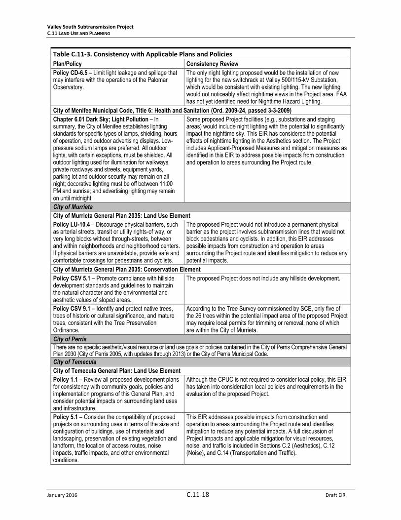
Table C.11-3. Consistency with Applicable Plans and Policies
Plan/Policy Consistency Review
Federal Aviation Administration
Title 14 Code of Federal Regulations Part 77
The FAA standards for marking and lighting structures to promote aviation safety are applicable to any temporary or permanent structures including all appurtenances that exceed an overall height of 200 feet above ground level or exceed any obstruction standard contained in Title 14 Code of Federal Regulations Part 77.
The proposed Project does not include structures over 200 feet, however, the project description includes coordination and follow up with the FAA regarding any marking and lighting requirements that may be required.
State of California
Caltrans Scenic Highway Mapping System and California Highway Code
The Scenic Highway Program was created to preserve and protect scenic highway corridors from changes that would diminish the aesthetic value of lands adjacent to highways. The State Scenic Highway System includes highways that are either eligible for designation as scenic highways or have been designated as such. Streets and Highways Code Section 260-263 defines California’s scenic highways.
Based on the Scenic Highway Mapping System, there are no Designated State Scenic Highways in the viewshed of the proposed Project. SR-74 (north of the proposed Project) and I-15 (south and east of the proposed Project) have been classified Eligible State Scenic Highways.
County of Riverside
Riverside County General Plan: Land Use Element
Policy LU 4.1 – Require that new developments be located and designed to visually enhance, not degrade the character of the surrounding area through consideration of the following concepts:
Compliance with the design standards of the appropriate area plan land use category.
l. Mitigate noise, odor, lighting, and other impacts on surrounding properties.
The proposed Project would introduce either a new or taller and more complex wood, TSP, or LWS-pole subtransmission line into landscapes presently absent similar facilities or landscapes with smaller and less complex facilities, potentially resulting in visual impacts. These outcomes may not be consistent with the requirement to enhance, not degrade the visual character of the surrounding area.
Policy LU 5.4 - Ensure that development and conservation land uses do not infringe upon existing public utility corridors, including fee owned rights-of-way and permanent easements, whose true land use is that of “public facilities.” This policy will ensure that the “public facilities” designation governs over what otherwise may be inferred by the large scale general plan maps.
The Project would be constructed in established rights-of-way (ROWs). Prior to Project construction, SCE would acquire approximately 4.4 miles of new or upgraded easements. Upgrading easements may include adding land rights, adding width to existing easements, improving or clarifying access or maintenance rights.
Policy LU 6.1 – Require land uses to develop in accordance with the General Plan and area plans to ensure compatibility and minimize impacts.
The proposed Project would introduce either a new or taller and more complex wood, TSP, or LWS-pole subtransmission line into landscapes presently absent similar facilities or landscapes with smaller and less complex facilities, resulting in potentially adverse visual impacts. These outcomes may not be consistent with the requirement to ensure compatibility and minimize impacts.
Policy LU 6.4 – Retain and enhance the integrity of existing residential, employment, agricultural, and open space areas by protecting them from encroachment of land uses that would result in
The proposed Project would introduce either a new or taller and more complex wood, TSP, or LWS-pole subtransmission line into landscapes presently absent similar facilities or landscapes with smaller and less complex facilities, potentially resulting in visual

Valley South Subtransmission Project C.11 LAND USE AND PLANNING
January 2016 C.11-14 Draft EIR
Table C.11-3. Consistency with Applicable Plans and Policies
Plan/Policy Consistency Review
impacts from noise, noxious fumes, glare, shadowing, and traffic.
impacts. These outcomes may not be consistent with the requirement to retain and enhance the integrity of existing landscapes.
Policy LU 11.1 – Apply the following policies to areas where development is allowed and that contain natural slopes, canyons, or other significant elevation changes, regardless of land use designation:
d. Restrict development on visually significant ridgelines, canyon edges and hilltops through sensitive siting and appropriate landscaping to ensure development is visually unobtrusive.
The proposed Project is not sited on any visually significant ridgelines, canyon edges, or hilltops.
Policy LU 13.1 – Preserve and protect outstanding scenic vistas and visual features for the enjoyment of the traveling public.
Portions of the proposed Project could partially obscure views to hills, ridges, and mountain ranges, including Mount San Jacinto, when viewed from public roads. The Project could result aesthetic effects, which may not be consistent with the requirement to preserve and protect visual features for the enjoyment of the traveling public.
Policy LU 13.3 – Ensure that the design and appearance of new landscaping, structures, equipment, signs, or grading within Designated and Eligible State and County scenic highway corridors are compatible with the surrounding scenic setting or environment.
SR-74 and I-15 are State Eligible Scenic Highways, and I-215 (McCall Boulevard to I-15), McCall Boulevard (I-215 to Menifee Road), and Menifee Road (McCall Boulevard to SR-74) are Riverside County Eligible Scenic Highways. In all cases, either the proposed Project would not be visible from the eligible roadway, or the Project components that would be visible would be consistent with the existing landscape conditions.
Policy LU 13.4 – Maintain at least a 50-foot setback from the edge of the right-of-way for new development adjacent to Designated and Eligible State and County Scenic Highways.
The northern-most segment of the proposed Project would span Menifee Road, which is a County Eligible Scenic Highway in this location. Although the proposed Project may not be consistent with the requirement for a 50-foot setback from the Eligible Scenic Highway, this portion of the Project would be located within an existing corridor and would involve replacing existing LWS poles with new LWS poles.
Policy LU 13.5 – Require new or relocated electric or communication distribution lines, which would be visible from Designated and Eligible State and County Scenic Highways, to be placed underground.
The northern-most segment of the proposed Project would span Menifee Road, which is a County Eligible Scenic Highway in this location. Although the proposed Project may not be consistent with the requirement to underground new or relocated utility lines if visible from Eligible County Scenic Highways, this portion of the Project would be located within an existing corridor and would involve replacing existing LWS poles with new LWS poles.
Policy LU 13.8 – Avoid the blocking of public views by solid walls.
The proposed Project does not include the construction of solid walls that would block public views of scenic features.
Policy LU 20.1 – Require that structures be designed to maintain the environmental character in which they are located.
The proposed Project would introduce either a new or taller and more complex wood, TSP, or LWS-pole subtransmission line into landscapes presently absent similar facilities or landscapes with smaller and less complex facilities, potentially resulting in visual impacts, which may not be consistent with this policy.
Policy LU 20.2 – Require that development be designed to blend with undeveloped natural contours of the site and avoid an unvaried, unnatural, or manufactured appearance.
The tall, vertical forms of the proposed Project’s wood, TSP, and LWS poles would not blend with the flat, horizontal natural contours of the undeveloped lands through that portions of the Project would pass. Also, the industrial character of some Project structures may not be consistent with the natural character of some of the landscapes through which the Project would pass. These outcomes may not be consistent with this policy.
Policy LU 20.4 – Ensure that development does not adversely impact the open space and rural character of the surrounding area.
The proposed Project would introduce either a new or taller and more complex wood, TSP, or LWS-pole subtransmission line into landscapes presently absent similar facilities or landscapes with smaller and less complex facilities. The introduction of industrial character and impairment of public views of higher value landscape

Valley South Subtransmission Project C.11 LAND USE AND PLANNING
Draft EIR C.11-15 January 2016
Table C.11-3. Consistency with Applicable Plans and Policies
Plan/Policy Consistency Review
features (sky, ridges, and mountains) may adversely impact the open space and rural character along the Project corridor.
Policy LU 25.1: Accommodate the development of public facilities in areas appropriately designated by the General Plan and area plan land use maps.
The Project would be constructed in established ROWs that include fee-owned ROWs and franchise ROWs. SCE would acquire approximately 4.4 miles of new or upgraded easements, and would obtain all necessary rights and permits for these easements.
Riverside County General Plan: Circulation Element
Policy C 19.1 – Preserve scenic routes that have exceptional or unique visual features in accordance with Caltrans’ Scenic Highways Plan.
The proposed Project would not impair views of exceptional or unique visual features from designated or eligible State scenic routes (see State of California, above, in this table).
Policy C 25.2 – Locate new and relocated utilities underground when possible. All remaining utilities shall be located or screened in a manner that minimizes their visibility by the public.
The proposed Project includes an underground component and this EIR considers an underground alternative on a portion of the route. In addition, the EIR includes analysis of aesthetics/visual resources. Therefore, the proposed Project addresses this policy.
Riverside County General Plan: Multipurpose Open Space Element
Policy OS 20.2 – Prevent unnecessary extension of public facilities, services, and utilities, for urban uses, into Open Space-Conservation designated areas.
The proposed Project would be constructed in established ROWs and approximately 4.4 miles of new or upgraded easements. SCE would be required to obtain permits/approvals for these easements.
Policy OS 21.1 – Identify and conserve the skylines, view corridors, and outstanding scenic vistas within Riverside County.
The proposed Project would be an aboveground facility, components of which may result in potentially impaired public views of background skylines, ridges, and mountains.
Policy OS 22.1 – Design developments within designated scenic highway corridors to balance the objectives of maintaining scenic resources with accommodating compatible land uses.
The proposed Project would not be located within a designated scenic corridor.
Policy OS 22.3 – Encourage joint efforts among federal, state, and County agencies, and citizen groups to ensure compatible development within scenic corridors.
The proposed Project would not be located within a designated scenic corridor.
Policy OS 22.4 – Impose conditions on development within scenic highway corridors requiring dedication of scenic easements consistent with the Scenic Highways Plan, when it is necessary to preserve unique or special visual features.
The proposed Project would not be located within a designated scenic corridor.
Riverside County: Harvest Valley/Winchester Area Plan
Policy HVWAP 9.1 – Adhere to the lighting requirements specified in [Riverside] County Ordinance No. 655 for standards that are intended to limit light leakage and spillage that may interfere with the operations of the Mount Palomar Observatory.
The only night lighting proposed would be the installation of new lighting for the new switchrack at the Valley 500/115-kV Substation, which would be consistent with the lighting on existing switchracks. The new lighting would not noticeably affect nighttime views in the proposed Project area. The need for nighttime Hazard Lighting has not yet been determined by the FAA.
Policy HVWAP 14.1 – Protect the scenic highways in the Harvest Valley/Winchester planning area from change that would diminish the aesthetic value of adjacent properties in accordance with the Scenic Corridors sections of the General Plan Land Use, Multipurpose Open Space, and Circulation Elements.
The northern-most segment of the proposed Project would span Menifee Road, which is a County Eligible Scenic Highway in this location. This portion of the Project would be located within an existing corridor and would involve replacing existing LWS poles with new LWS poles. Therefore, the Project would not substantially diminish the aesthetic value of properties adjacent to the Highway.
Riverside County: Sun City/Menifee Valley Area Plan
Policy SCMVAP 12.1 – Adhere to the [Riverside] County lighting requirements for standards that are intended to limit light leakage and spillage that may interfere with the operations of the Palomar Observatory.
The only night lighting proposed would be the installation of new lighting for the new switchrack at the Valley500/115-kV Substation, which would be consistent with existing lighting. The new lighting would not noticeably affect nighttime views in the Project area. FAA has not determined the need for nighttime Hazard Lighting.

Valley South Subtransmission Project C.11 LAND USE AND PLANNING
January 2016 C.11-16 Draft EIR
Table C.11-3. Consistency with Applicable Plans and Policies
Plan/Policy Consistency Review
Policy SCMVAP 17.1 – Protect the scenic highways in the Sun City/Menifee Valley Area Plan from change that would diminish the aesthetic value of adjacent properties in accordance with the Scenic Corridors sections of the General Plan Land Use, Multipurpose Open Space, and Circulation Elements.
The northern-most segment of the proposed Project would span Menifee Road, which is a County Eligible Scenic Highway, just south of SR-74 (State Eligible Scenic Highway). This portion of the Project would be in an existing corridor and involve replacing existing LWS poles with new slightly different LWS poles. The Project would not substantially diminish the aesthetic value of properties adjacent to the State and County Highways in this area.
Riverside County: Southwest Area Plan
Policy SWAP 13.1 – Adhere to the lighting requirements of [Riverside County] ordinances for standards that are intended to limit light leakage and spillage that may interfere with the operations of the Palomar Observatory.
The only night lighting proposed would be the installation of new lighting for the new switchrack at Valley 500/115-kV Substation, which would be consistent with existing lighting. The new lighting would not noticeably affect nighttime views in the Project area. FAA has not determined the need for nighttime Hazard Lighting.
Policy SWAP 19.1 – Protect the scenic highways in the Southwest planning area from change that would diminish the aesthetic value of adjacent properties in accordance with the Scenic Corridors sections of the General Plan Land Use, Multipurpose Open Space, and Circulation Elements.
The southern portion of the proposed Project would be located approximately three or more miles east of I-215 (County Eligible Scenic Highway) and I-15 (State Eligible Scenic Highway) and would not noticeably diminish the aesthetic values of properties adjacent to these highways.
Riverside County: Winchester Properties/Silverhawk Specific Plan (#213)
Design Guideline 11 (Utilities and Communication Devices). All utilities and communication devices shall be designed, installed, and located as follows, unless otherwise specifically required by the applicable utility company:
-All exterior on-site utilities (e.g., electrical and communication wires and equipment) shall be installed and maintained underground in order to avoid unsightly overhead power and telephone lines, utility poles, and other utility and communication equipment and components.
-On-site underground utilities shall be designed and installed to minimize the disruption of off-site utilities, paving, and landscaping during construction and maintenance, and shall be of such a design so as not to place excessive burdens upon off-site utility systems during the course of use.
-Temporary overhead power and telephone facilities are permitted during construction.
The proposed Project includes an underground component and this EIR evaluates an underground alternative on a portion of the route. In addition, the Project includes Applicant-Proposed Measures and mitigation measures as identified in this EIR to address possible impacts from construction and operation to areas surrounding the proposed Project.
Riverside County: Crown Valley Village Specific Plan (#238)
Design Guidelines (Utilities):
-All utility services shall be installed underground; lines are to be located in improved area.
-Locate exterior transformers or utility pads out of view or screen with walls, fences or vegetation.
-Electrical service shall be mounted at the lowest height permitted by the electric company.
The proposed Project includes an underground component and this EIR evaluates an underground alternative on a portion of the route. In addition, the Project includes Applicant-Proposed Measures and mitigation measures as identified in this EIR to address possible impacts from construction and operation to areas surrounding the proposed Project.
Riverside County: Borel Airpark Specific Plan (#265)
Design Guidelines (Utilities). All utility lines shall be installed underground. No permanent overhead lines on site will be permitted. No transformer pads shall be permitted in the front yard landscaped setback areas. Where transformer pads may be seen from any
The proposed Project includes an underground component and this EIR evaluates an underground alternative on a portion of the route. In addition, the Project includes Applicant-Proposed Measures and mitigation measures as identified in this EIR to address possible impacts from construction and operation to areas surrounding the

Valley South Subtransmission Project C.11 LAND USE AND PLANNING
Draft EIR C.11-17 January 2016
Table C.11-3. Consistency with Applicable Plans and Policies
Plan/Policy Consistency Review
street, they will be screened with landscaping of an appropriate height or walls similar in treatment to adjacent buildings.
All other above ground utility appurtenances, regardless of the location on the parcel, shall be screened with landscape planting.
proposed Project.
City of Menifee
City of Menifee General Plan: Land Use Element
Policy LU-1.8 – Ensure new development is carefully designed to avoid or incorporate natural features, including washes, creeks, and hillsides.
The Project includes Applicant-Proposed Measures and mitigation measures as identified in this EIR to address possible impacts from construction and operation to areas surrounding the Project route.
Policy LU-3.1 – Work with utility providers in the planning, designing, and siting of distribution and support facilities to comply with the standards of the General Plan and Development Code.
This Project involves an application from an investor-owned utility for a subtransmission line project. The comments submitted by the City during scoping have been considered in this EIR and will be considered by the CPUC.
Policy LU-3.2 – Work with utility providers to increase service capacity as demand increases.
The Project objectives include providing safe and reliable electrical service, maintaining and improving system reliability, and providing greater operational flexibility within the service area.
Policy LU-3.4 – Require that approval of new development be contingent upon the project's ability to secure appropriate infrastructure services.
The proposed Project would improve electrical service in the area for new developments that would be considered by the City.
Policy LU-3.5 – Facilitate the shared use of right-of-way, transmission corridors, and other appropriate measures to minimize the visual impact of utilities infrastructure throughout Menifee.
The proposed Project would be constructed in established ROWs and would include approximately 4.4 miles of new or upgraded easements. Some of the new structures would be collocated. Visual impacts have been addressed in this EIR.
City of Menifee General Plan: Circulation Element
Policy C-6.5 – Ensure that the design and appearance of new landscaping, structures, equipment, signs, or grading within eligible County scenic highway corridors are compatible with the surrounding scenic setting or environment.
I-215 (McCall Boulevard to I-15), McCall Boulevard (I-215 to Menifee Road), and Menifee Road (McCall Boulevard to SR-74) are Riverside County Eligible Scenic Highways. In all cases, either the proposed Project would not be visible from the eligible highways, or the Project components that would be visible would be consistent with the existing landscape conditions.
City of Menifee General Plan: Open Space and Conservation Element
Policy OSC-3.1 – Identify and preserve the view corridors and outstanding scenic vistas within the City.
I-215 (McCall Boulevard to I-15), McCall Boulevard (I-215 to Menifee Road), and Menifee Road (McCall Boulevard to SR-74) are Riverside County Eligible Scenic Highways. In all cases, either the proposed Project would not be visible from the eligible highways, or the Project components that would be visible would be consistent with the existing landscape conditions.
Policy OSC-3.4 – Support the preservation of natural vegetation and rock outcroppings during and after the construction process.
The proposed Project would locate new construction either within an existing utility ROW or on agricultural land that has already been disturbed. The remainder of the proposed Project would involve replacing existing conductors on existing structures. Therefore, the proposed Project would minimize impacts on natural vegetation and rock outcroppings during and after the construction process.
City of Menifee General Plan: Community Design Element
Policy CD-4.8 – Preserve and enhance view corridors by undergrounding and/or screening new or relocated electric or communication distribution lines, which would be visible from the City’s scenic highway corridors.
I-215 (McCall Boulevard to I-15), McCall Boulevard (I-215 to Menifee Road), and Menifee Road (McCall Boulevard to SR-74) are Riverside County Eligible Scenic Highways. In all cases, either the proposed Project would not be visible from the eligible highways, or the Project components that would be visible would be consistent with the existing landscape conditions.
Valley South Subtransmission Project C.11 LAND USE AND PLANNING
January 2016 C.11-18 Draft EIR
Table C.11-3. Consistency with Applicable Plans and Policies
Plan/Policy Consistency Review
Policy CD-6.5 – Limit light leakage and spillage that may interfere with the operations of the Palomar Observatory.
The only night lighting proposed would be the installation of new lighting for the new switchrack at Valley 500/115-kV Substation, which would be consistent with existing lighting. The new lighting would not noticeably affect nighttime views in the Project area. FAA has not yet identified need for Nighttime Hazard Lighting.
City of Menifee Municipal Code, Title 6: Health and Sanitation (Ord. 2009-24, passed 3-3-2009)
Chapter 6.01 Dark Sky; Light Pollution – In summary, the City of Menifee establishes lighting standards for specific types of lamps, shielding, hours of operation, and outdoor advertising displays. Low-pressure sodium lamps are preferred. All outdoor lights, with certain exceptions, must be shielded. All outdoor lighting used for illumination for walkways, private roadways and streets, equipment yards, parking lot and outdoor security may remain on all night; decorative lighting must be off between 11:00 PM and sunrise; and advertising lighting may remain on until midnight.
Some proposed Project facilities (e.g., substations and staging areas) would include night lighting with the potential to significantly impact the nighttime sky. This EIR has considered the potential effects of nighttime lighting in the Aesthetics section. The Project includes Applicant-Proposed Measures and mitigation measures as identified in this EIR to address possible impacts from construction and operation to areas surrounding the Project route.
City of Murrieta
City of Murrieta General Plan 2035: Land Use Element
Policy LU-10.4 – Discourage physical barriers, such as arterial streets, transit or utility rights-of way, or very long blocks without through-streets, between and within neighborhoods and neighborhood centers. If physical barriers are unavoidable, provide safe and comfortable crossings for pedestrians and cyclists.
The proposed Project would not introduce a permanent physical barrier as the project involves subtransmission lines that would not block pedestrians and cyclists. In addition, this EIR addresses possible impacts from construction and operation to areas surrounding the Project route and identifies mitigation to reduce any potential impacts.
City of Murrieta General Plan 2035: Conservation Element
Policy CSV 5.1 – Promote compliance with hillside development standards and guidelines to maintain the natural character and the environmental and aesthetic values of sloped areas.
The proposed Project does not include any hillside development.
Policy CSV 9.1 – Identify and protect native trees, trees of historic or cultural significance, and mature trees, consistent with the Tree Preservation Ordinance.
According to the Tree Survey commissioned by SCE, only five of the 26 trees within the potential impact area of the proposed Project may require local permits for trimming or removal, none of which are within the City of Murrieta.
City of Perris
There are no specific aesthetic/visual resource or land use goals or policies contained in the City of Perris Comprehensive General Plan 2030 (City of Perris 2005, with updates through 2013) or the City of Perris Municipal Code.
City of Temecula
City of Temecula General Plan: Land Use Element
Policy 1.1 – Review all proposed development plans for consistency with community goals, policies and implementation programs of this General Plan, and consider potential impacts on surrounding land uses and infrastructure.
Although the CPUC is not required to consider local policy, this EIR has taken into consideration local policies and requirements in the evaluation of the proposed Project.
Policy 5.1 – Consider the compatibility of proposed projects on surrounding uses in terms of the size and configuration of buildings, use of materials and landscaping, preservation of existing vegetation and landform, the location of access routes, noise impacts, traffic impacts, and other environmental conditions.
This EIR addresses possible impacts from construction and operation to areas surrounding the Project route and identifies mitigation to reduce any potential impacts. A full discussion of Project impacts and applicable mitigation for visual resources, noise, and traffic is included in Sections C.2 (Aesthetics), C.12 (Noise), and C.14 (Transportation and Traffic).

Valley South Subtransmission Project C.11 LAND USE AND PLANNING
Draft EIR C.11-19 January 2016
Table C.11-3. Consistency with Applicable Plans and Policies
Plan/Policy Consistency Review
Policy 6.1 – Preserve the natural aesthetic quality of hillsides and reduce hazards associated with hillside development within the Planning Area.
The proposed Project does not include any hillside development.
Policy 8.3 – Ensure development projects within the French Valley Airport area of influence comply with the Airport Land Use Compatibility Plan (ALUCP) for the Airport, and refer all land use actions identified within the ALUCP to the Airport Land Use Commission for mandatory review.
SCE would file a Notice of Proposed Construction or Alteration with the FAA for subtransmission and telecommunication structures and wire spans that exceed regulatory thresholds. SCE would adopt any recommended changes to the design of proposed structures based on the FAA determination.
Policy 8.4 – Ensure that development proposals within the French Valley Airport area of influence fully comply with the permit procedures specific in federal and state law, with the referral requirements of the Airport Land Use Commission (ALUC), and with the conditions of approval imposed or recommended by the FAA and ALUC. This requirement is in addition to all other City development review requirements.
SCE would file a Notice of Proposed Construction of Alteration with the FAA for subtransmission and telecommunication structures and wire spans that exceed regulatory thresholds. SCE would adopt any recommend changes to the design of proposed structures based on the FAA determination.
City of Temecula General Plan: Open Space/Conservation Element
Policy 5.8 – Require re-vegetation of graded slopes concurrent with project development to minimize erosion and maintain the scenic character of the community.
The proposed Project does not include any hillside development.
City of Temecula General Plan: Community Design Element
Policy 2.5 – Limit light and glare pollution through design standards for outdoor lighting, the use of low intensity lights, and lighting that supports the continued use of the Mt. Palomar Observatory.
The only night lighting proposed would be the installation of new lighting for the new switchrack at the Valley 500/115-kV Substation, which would be consistent with the existing lighting. The new lighting would not noticeably affect nighttime views in the proposed Project area. The need for nighttime Hazard Lighting has not yet been determined by the FAA.
Policy 5.6 - Promote and implement underground utilities (cable, power, etc.) where feasible.
The only portion of the proposed Project within the City of Temecula would be the reconductoring of an existing subtransmission line carried on existing poles that support multiple subtransmission and distribution lines. The resulting aesthetic effect would be negligible and would not warrant undergrounding.
Sources: Caltrans, 2013; City of Menifee, 2009, 2013a to 2013f; City of Murrieta, 2011; City of Perris, 2005, 2012; City of Temecula, 2003, 2005a to 2005c; FAA, 2015; County of Riverside, 2001, 2002, 2010, 2012, 2014a to 2014f, 2015; State of California, 2014.
C.11.4.3 Cumulative Impacts
Geographic Extent/Context
Land uses directly affected by the proposed Project would include those that are located either adjacent
to the proposed Project ROW or a proposed material staging area. In order to determine whether
affected land uses would be cumulatively impacted by other past or reasonably foreseeable future
projects, the geographic extent for the land use cumulative effects analysis includes projects that have
been identified within one-half mile of the proposed Project, which is consistent with the Land Use
Study Area that was used to identify existing land uses for the proposed Project (see Section C.11.1).
Consequently, this geographic extent sufficiently encompasses any residential and non-residential land
uses that may be cumulatively affected by the proposed Project.

Valley South Subtransmission Project C.11 LAND USE AND PLANNING
January 2016 C.11-20 Draft EIR
Existing Cumulative Conditions
Past and ongoing residential and commercial development has changed the character of the Study Area
from a primarily agricultural region to include more populated and urbanized areas. Local city
jurisdictions and Riverside County continue to develop and revise area plans and specific plans to
identify resources and address the needs of their growing communities.
Cumulative Impact Analysis
The potential for land use and planning impacts of the proposed Project (described in Section C.11.4.2)
to combine with the effects of other proposed, planned, and reasonably foreseeable future projects, as
listed in Table C.1-1 that are within the geographic extent of the cumulative analysis are described
below for each significance criterion.
Criterion LU1: Preclude a permitted land use, or create a disturbance that would diminish the function
of a particular land use.
Proposed Project construction would cause temporary disturbances to adjacent residences due to site-
specific access limitations, increased traffic and congestion along construction routes and detour routes,
increased dust generation and noise, and changes in the overall visual character of an area due to the
presence of construction-related equipment, personnel, and associated activities (Impact LU-1). Similar
impacts to residences from construction-related noise and traffic of other projects in the Study Area
(see Table C.1-1) could potentially occur within the same timeframe as the proposed Project. Mitigation
Measures LU-1 (Property Access and Restoration), AQ-1 (Fugitive Dust Control), NOI-1 (Construction
Work Hours), and NOI-2 (Implement Best Management Practices for Construction Noise) would be
applied to the proposed Project to reduce the severity of short-term impacts to residences. Given the
effectiveness of proposed mitigation, the proposed Project’s cumulative contribution would be less than
significant (Class III).
Construction of the proposed Project would cause temporary disturbances to non-residential uses that
would be minimized with implementation of Mitigation Measures LU-1 (Property Access and
Restoration), AQ-1 (Fugitive Dust Control), NOI-1 (Construction Work Hours), and NOI-2 (Implement Best
Management Practices for Construction Noise). The proposed Project would also avoid impacts to
nearby airports/airstrips by complying with FAA notification requirements. The greatest impacts to non-
residential uses during Project construction would occur at Heritage High School (Impact LU-2). Impacts
to the high school would be avoided to the degree feasible through implementation of Mitigation
Measure LU-2 (Coordination with School District). None of the cumulative projects listed in Table C.1-1
would be in close enough proximity to the high school to create construction-related impacts that would
be similar to the proposed Project. However, a portion of the proposed Project’s new ROW would be
constructed along the property line of Perris Union High School District’s proposed site for its High
School No. 4, at the southeast corner of Leon Road and Wickerd Road. The school district is currently in
the planning phase for the new high school, and no construction schedule has been released. In the
event that construction of the new high school overlaps with the proposed Project construction
schedule, impacts from construction-related noise and traffic would be cumulatively considerable.
Mitigation similar to Mitigation Measure LU-2 (Coordination with School District), which requires
coordination with Perris Union High School in regards to construction schedules, would be
recommended to reduce cumulative impacts to a less-than-significant level (Class II).

Valley South Subtransmission Project C.11 LAND USE AND PLANNING
Draft EIR C.11-21 January 2016
Criterion LU2: Conflict with any applicable federal, State, or local land use plans, goals, or policies.
The proposed Project is subject to the discretionary review and approval of the CPUC. The Project would
be required to comply with State and federal requirements, but is exempt from local agency
requirements. However, CPUC regulations require that SCE consult with local agencies regarding land
use matters. In combination with other projects proposed in the area, the proposed Project would not
create a conflict with applicable plans, goals, or policies that would be cumulatively considerable.
C.11.4.4 Impact and Mitigation Summary
This section summarizes the conclusions of the impact analysis and associated mitigation measures
presented in Section C.11.4.2 for the proposed Project. Table C.11-4 lists each impact identified for the
proposed Project, along with the significance of each impact.
Table C.11-4. Impact and Mitigation Summary – Land Use and Planning
Impact Significance Conclusion
Reason for Conclusion
LU-1: Construction of the Project could temporarily disrupt, displace, or preclude existing residential land uses.
Class II Impacts to residences would be minimized during Project construction by ensuring that property owners could continue to access their property (Mitigation Measure LU-1: Property Access and Restoration), by controlling fugitive dust generated during Project construction (Mitigation Measure AQ-1: Fugitive Dust Control), by notifying residents of construction activities (Mitigation Measure NOI-1: Construction Work Hours), and by establishing a Project hotline to answer noise questions and handle complaints (Mitigation Measure NOI-2: Implement Best Management Practices for Construction Noise).
LU-2: Construction of the Project could temporarily disrupt, displace, or preclude existing non-residential land uses
Class II Conflicts with the operations at Heritage High School during Project construction would be minimized through coordination with Perris Union High School District and the high school (Mitigation Measure LU-2: Coordination with School District). Additional construction impacts to non-residential land uses would be avoided or reduced by ensuring that property owners could continue to access their property (Mitigation Measure LU-1: Property Access and Restoration), by controlling fugitive dust generated during Project construction (Mitigation Measure AQ-1: Fugitive Dust Control), by notifying property owners of construction activities (Mitigation Measure NOI-1: Construction Work Hours), and by establishing a Project hotline to answer noise questions and handle complaints (Mitigation Measure NOI-2: Implement Best Management Practices for Construction Noise).
Class I: Significant impact; cannot be mitigated to a level that is not significant. A Class I impact is a significant adverse effect that cannot be mitigated below a level of significance through the application of feasible mitigation measures. Class I impacts are significant and unavoidable.
Class II: Significant impact; can be mitigated to a level that is not significant. A Class II impact is a significant adverse effect that can be reduced to a less than significant level through the application of feasible mitigation measures presented in this EIR.
Class III: Adverse; less than significant. A Class III impact is a minor change or effect on the environment that does not meet or exceed the criteria established to gauge significance.
Class IV: Beneficial impact. A Class IV impact represents a beneficial effect that would result from project implementation.