c.6 hydrology and water resources - california
TRANSCRIPT

October 2001October 2001 C.6-1 Draft SEIR Draft SEIR
C.6 HYDROLOGY AND WC.6 HYDROLOGY AND WATER RESOURCESATER RESOURCES
This chapter describes existing hydrologic conditions in the project area and also describes potential impacts due to the construction and operation of the Proposed Project and Alternatives. Topics addressed include the surface water drainage network, surface runoff, flooding, surface water quality, erosion and sediment transport, stream channel geomorphology, groundwater hydrology, and groundwater quality conditions.
Hydrologic conditions in the project area were investigated through reviewing prior studies regarding the project area, obtaining available information from local city, regional, county, and state agencies, and conducting a field visit to the project area. The potential impacts of the Proposed Project and Alternatives on surface water and groundwater were evaluated in terms of required construction activities and the long-term operation and maintenance of the proposed substations and transmission lines. When evaluating the potential project impacts, it was assumed that PG&E would comply with all applicable federal, state, and local regulatory requirements that protect surface water and groundwater.
The 1988 FEIS/EIR included a brief survey of water resources in the project area including descriptions of surface water and water supply features. This SEIR includes a more thorough reporting of baseline environmental conditions including flooding, groundwater, water quality, and wetland issues that were not addressed in the original EIR document. Additionally, applicable regulations, plans, and standards are presented in this SEIR along with a discussion of significance criteria. Impacts described in the original EIR were fairly generic and not identified (or numbered) as discrete identifiable impacts. In this SEIR, twelve impacts associated with the Proposed Project and Alternatives and relevant mitigation measures are described.
Specific differences between the 1988 FEIS/EIR and the current SEIR are as follows:Specific differences between the 1988 FEIS/EIR and the current SEIR are as follows:
A) The environmental setting has not significantly changed in the project area since the 1988 FEIS/EIR, however there are issues not reported in the 1988 FEIS/EIR that are described in the current report. The current report offers a more thorough description of runoff conditions in the project area. Since the 1988 FEIS/EIR, hydrology studies have been conducted in the southern project area following the floods of March 1995. These floods caused significant damage and loss of life in the project area. Therefore, since the FEIS/EIR, there is now a more complete understanding of discharge conditions and potential flood hazards in the southern project area. The presence of wetlands in the project area along Salt and Ortigalita creeks is another issue that was not described in the hydrology section of the 1988 FEIS/EIR.
B) In regards to the regulatory setting, one difference between the 1988 FEIS/EIR and this SEIR are the
1987 amendments to the Clean Water Act which established that discharge from developed areas be regulated under the National Pollutant Discharge Elimination System (NPDES).
C) The primary difference in methodology between the 1988 FEIS/EIR and the current SEIR is an increased
level of specificity in regard to potential constructional impacts associated with the Proposed Project. The 1988 FEIS/EIR stated that potential impacts to water quality would be relatively minor since no perennial streams would be crossed by the project. The current SEIR differs from this opinion. However, potential water quality impacts listed in the current SEIR are mitigable to a less than

C.6 HC.6 HYDROLOGY AND YDROLOGY AND WWATER ATER RRESOURCESESOURCES LLOS OS BBANOS ANOS –– G GAATES TES TTRANSMISSION RANSMISSION PPROJECTROJECT
Draft SEIRDraft SEIR C.6-2 October 2001October 2001
significant level through the application of mitigation measures. As a result, as for the 1988 FEIS/EIR, there are no Class I (unmitigable) impacts regarding water quality or other hydrology issues.
After evaluating potential project impacts, it was determined that the Eastern Corridor Alternative is preferred in the hydrology and water quality issue area for several reasons. Construction along the flatter Eastern Corridor will involve less potential erosion, runoff, and sediment transport impacts. The Eastern Corridor Alternative also requires fewer creek, reservoir, and other important wetland crossings (i.e. Salt and Ortigalita creek wetlands). The Eastern Corridor Alternative does not pass through the oil operations zone in the Coalinga area and therefore has a smaller chance of encountering contaminated soil or water in that area.
C.6.1C.6.1 EENVIRONMENTAL NVIRONMENTAL BBASELINEASELINE
C.6.1.1C.6.1.1 Regional Overview and Project Environmental SettingRegional Overview and Project Environmental Setting
Physical Settings and WatershedsPhysical Settings and Watersheds
The project area is located along the eastern flank of the Diablo Range through Fresno and Southern Merced Counties (Figures B-1a and B-1b). The southernmost portion of the project, improvements south of the Gates Substation, extends into Kings and Kern Counties. Along portions of the Proposed Project (Western Corridor), the transmission corridor is located in the more rugged terrain and steep hill slopes towards the interior of the Diablo Range. Along other portions of the alignment, the corridor is located in the gentler foothill zone that is transitional to the flatter San Joaquin Valley towards the east. The southern portion of the Proposed Project Corridor between the Coalinga area and the Gates Substation does enter the flatter terrain of the San Joaquin Valley. The Eastern Corridor Alternative is located in the flatter terrain of the San Joaquin Valley for much of its length. The project crosses four regional watersheds as delineated by the USGS. These include the Panoche-San Luis Reservoir, Middle San Joaquin-Lower Chowchilla, Upper Los Gatos-Avenal, and Tulare-Buena Vista Lakes watersheds (EPA, 2001).
Several stream courses drain northeastward out of the Diablo range and cross the project corridor. Many of the smaller streams terminate in the foothill and alluvial fan transition zone towards the San Joaquin Valley, while only the larger streams continue to flow out into the valley floor region.
Table C.6-1 lists the principal named intermittent and ephemeral streams that the Proposed Western Corridor crosses. The locations that each stream crosses along the Proposed or Alternative Corridors are listed (segment numbers and Mileposts are shown on Figure B-1a and B-1b).

LLOS OS BBANOS ANOS –– G GATES ATES TTRANSMISSION RANSMISSION PPROJECT ROJECT C.6 HC.6 HYDROLOGY AND YDROLOGY AND WWATER ATER RRESOURCESESOURCES
October 2001October 2001 C.6-3 Draft SEIRDraft SEIR
Table C.6Table C.6--1 Stream Locations1 Stream Locations
Proposed Western Corridor Alternative Western Segments Eastern Corridor Alternative
Stream (Segment / Milepost) (Segment) (Segment / Milepost)
Segments 2 or 2A and Segment 3
Los Banos Creek MP 6 Seg 2A MP 6.5
Salt Creek (Merced Co.) MP 9 Seg 2A MP 8.5
Ortigalita Creek MP 13.5 Seg 2A Seg 3 / MP 10.5
Segments 4 and 4A, and Segment 5
Little Panoche Creek MP 23 Seg 4A MP 23
Segment 5
Panoche Creek MP 36.5 Seg 4 / MP 35
Tumey Gulch MP 41.3 N/A*
Arroyo Ciervo MP 49.5 MP 48.5
Arroyo Hondo MP 52.7 MP 52
Cantua Creek MP 57.3 MP 57
Salt Creek (Fresno Co.) MP 58.6 MP 59.5
Martinez Creek MP 61.5 N/A*
Domengine Creek MP 64.6 MP 63
Segment 6
Los Gatos Creek MP 77.3 MP 79.5
Notes: Milepost distances are generally given to nearest ½ mile interval unless better information is available. *Blue line mapping of creek does not reach Eastern Corridor Alternative as some creeks become undistinguishable across alluvial fan surfaces.
RainfallRainfall--Runoff CharacteristicsRunoff Characteristics
Table C.6-2 includes summary statistics for temperature and precipitation conditions for stations at Los Banos and Coalinga in the project area. Located in the lee, or rain-shadow, of the Coast Ranges, the project area is very dry, whereby average annual precipitation is less than 10 inches. Consistent with central California’s Mediterranean climate, most of this rain falls between November and April. January and July are the wettest and driest months respectively and year to year climatic variations can be great. The mean annual evapo-transpiration rate is about 50 inches per year, a value that far exceeds annual precipitation. Observed maximum 1-day rainfalls in the project area can exceed 3.5 inches. The latitudinal difference between Los Banos and Coalinga results in warmer and drier conditions to the south.
Table C.6Table C.6--2 Temperature and Preci2 Temperature and Precipitationpitation
Location
Avg. Monthly Max Temp
(°F)
Avg. Monthly Min Temp
(°F)
Avg. Annual Precip.
(in)
Avg. Wettest Month
Avg. Precip. (in) for Wettest
Month
Avg. Driest Month
Avg. Precip. (in) for Driest
Month
Max. 1-Day Precip. (in)
(date) Los Banos (Merced Co.) 76.2 48.0 9.48 Jan 1.87 July 0.02 2.25
(9/30/83) Coalinga (Fresno Co.) 78.2 48.7 7.71 Jan 1.56 July 0.01 3.74
(3/10/95)

C.6 HC.6 HYDROLOGY AND YDROLOGY AND WWATER ATER RRESOURCESESOURCES LLOS OS BBANOS ANOS –– G GAATES TES TTRANSMISSION RANSMISSION PPROJECTROJECT
Draft SEIRDraft SEIR C.6-4 October 2001October 2001
The creeks in the project area are ephemeral or intermittent, flowing only seasonally during the winter months or directly following a storm event. Streamflow occurs when precipitation rates exceed infiltration rates and runoff is generated. Runoff generally occurs either as surface overland flow or shallow subsurface throughflow and is concentrated in natural swales or channels. Comparing annual streamflow volumes from Los Gatos Creek to annual precipitation records for the Coalinga station suggests that about 20 to 25 percent of annual precipitation results as streamflow runoff in the project area. The remaining precipitation is either absorbed by the soil or transpired by the region’s grassland vegetation.
Grazing on the hillslopes and valley floors in the project area has likely reduced the vegetative cover by converting native perennial grasslands to Mediterranean annual grasses. Grazing has also likely compacted and degraded the soil. As has been the case in many of the watersheds of California’s Coast Ranges and valleys, these changing physical conditions have likely resulted in increased peak runoff rates, destabilized creek banks, and increased channel incision in the project area. Grazing can also result in the de-watering of upland valleys due to lowered water tables, and degraded riparian plant communities along stream banks.
Table C.6-3 provides peak streamflow information for two gaging stations in the project area: Cantua Creek (near the Proposed Project Corridor) and Los Gatos Creek (just upstream of Coalinga and west of the Project Corridor). The top five and bottom five ranking maximum annual events are given for each gaging station. Large storm events in March of 1995 and 1983 generated flows of 5,700 cfs and 3,420 cfs for the Los Gatos and Cantua Creeks, respectively. An event in January 1993 also generated noteworthy flows for the two creeks. In terms of lowest ranking maximum streamflow conditions, during some dry years (1961 for Cantua Creek and 1989 for Los Gatos Creek) no observable streamflow occurs in the creeks. Table C.6-4 lists other available streamflow gages and surface water quality monitoring stations along the project corridor.

LLOS OS BBANOS ANOS –– G GATES ATES TTRANSMISSION RANSMISSION PPROJECT ROJECT C.6 HC.6 HYDROLOGY AND YDROLOGY AND WWATER ATER RRESOURCESESOURCES
October 2001October 2001 C.6-5 Draft SEIRDraft SEIR
Table C.6Table C.6--3 Peak Streamflow Conditions3 Peak Streamflow Conditions
Cantua Creek
Drainage Area = 46.4 sq mi 43 yrs of record (1958-2000)
Los Gatos Creek Drainage Area = 95.8 sq mi 55 yrs of record (1945-2000)
Rank of Annual Streamflow Event Date Gage Height
(ft) Discharge (cfs) Date Gage Height (ft) Discharge (cfs)
Max annual peak events
1 3/1/83 5.72 3,420 3/10/95 NA 5,700
2 3/10/95 7.13 2,970 2/24/69 10.34 4,360
3 9/23/90 5.05 2,430 1/14/93 12.08 3,820
4 1/14/93 4.76 2,020 1/16/78 10.65 3,820
5 3/20/91 4.7 1,940 3/2/83 8.75 3,680 Min annual peak events (Cantua/Los Gatos)
39/51 2/19/94 2.07 19.0 3/3/49 NA 25.4
40/52 3/11/85 2.03 16.0 11/23/46 NA 21.3
41/53 4/1/68 1.86 9.1 12/31/76 4.74 15.0
42/54 4/12/99 1.2 8.0 11/19/67 4.32 12.0
43/55 1961 0 0 9/30/89 0 0.0
Flooding IssuesFlooding Issues
The 1986 Draft EIS/EIR for the Proposed Project (TANC/WAPA, 1986) included a Water Resources Map that indicated 100-year floodplains and proposed designated floodways. Federal Emergency Management Association (FEMA) Flood Insurance Rate Maps (FIRM) from 1982 were used as reference for that document. Since that time, additional FEMA mapping and revisions in the project area have occurred in 1995 and 1999. On these more recent maps, the designations of 100-year floodplains or Proposed Designated Floodways as shown on the Water Resources Route Data Map from the 1986 Draft EIS/EIR have not been altered. Areas subject to a 100-year flood occur primarily in the Eastern Corridor Alternative, with a few locations in the Western Corridor (TANC/WAPA, 1986). The 1995 FEMA maps for Merced County indicate that the Path 15 Corridor is zoned as either D or X, with no detailed FIRMs printed for the entire study area. According to FEMA, Zones D and X are defined as follows:
“The Zone D designation on NFIP maps is used for areas where there are possible but undetermined flood hazards. In areas designated as Zone D, no analysis of flood hazards has been conducted. Zone X is the flood insurance rate zone that corresponds to the areas outside the 500-year floodplain, areas within the 500-year floodplain, areas of 100-year flooding where average depths are less than 1 foot, areas of 100-year flooding where the contributing drainage area is less than 1 square mile, and areas protected from the 100-year flood by levees. No base flood elevations or depths are shown within this zone.”
FEMA Flood Insurance Studies for Fresno County have recently been undertaken with FIRMs to be available in 2001 (and were released to the public too late to review for this Draft SEIR). It is expected that most flood zones within Fresno County will be concentrated in the incorporated areas of the Cities of Coalinga, Huron, and possibly Panoche Creek, which is a source of flooding for the City of Modesto. It is unlikely that the FIRM maps due to be released in 2001 will introduce altered floodplain boundaries from the Draft EIS/EIR (TANC/WAPA, 1986). These maps can be evaluated when they become available.

LLOS OS BBANOS ANOS –– G GATES ATES TTRANSMIRANSMISSION SSION PPROJECT ROJECT C.6 HC.6 HYDROLOGY AND YDROLOGY AND WWATER ATER RRESOURCESESOURCES
October 2001October 2001 C.6-6 Admin. Final EIR Admin. Final EIR
Table C.6Table C.6--4 USGS Streamflow and Water Qua4 USGS Streamflow and Water Quality Surface Flow Gages in Vicinity of Path 15 Projectlity Surface Flow Gages in Vicinity of Path 15 Project
Station ID Name Latitude Longitude Horizontal Datum
Drainage Area Elevation Vertical Datum Station Data Begin Date End Date Status
Peak streamflow 7-Oct-45 present Current 11224500
LOS GATOS C AB NUNEZ CYN NR COLAINGA CA
36o12'53"N
120o28'11"W
NAD27
95.8
1065.2 NGVD29
Daily streamflow 1-May-45 present Current 11253310 36o24'08" 120o25'57" NAD27 46.4 680 NGVD29 Peak streamflow 2-Apr-58 present Current
CANTUA C NR CANTUA CREEK CA Daily streamflow 1-Oct-66 present Current
11255575 36o39'09" 120O37'52" NAD27 305.27 40 NGVD29 Peak streamflow 7-Oct-45 present Current Daily streamflow 1-May-45 present Current
PANOCHE C A I-5 NR SILVER CREEK CA
Water Quality1 19-Jan-98 present Current
11262890 SAN LUIS DR SITE A NR S DOS PALOS CA 36o57'53" 120o40'08" NAD27 -- 115 NGVD29 Daily streamflow 1-Oct-98 present Current
11262895 SAN LUIS DR SITE B NR STEVINSON CA 37o14'27" 120o52'37" NAD27 -- 75 NGVD29 Daily streamflow 1-Oct-98 present Current
37o145'45" 120o54'20" NAD27 -- 25 NGVD29 Peak streamflow 16-Mar-86 present Current Daily streamflow 1-Oct-85 present Current
11262900
MUD SLOUGH NR GUSTINE CA Water Quality1 11-Jun-85 present Current
11225000 36o13'00" 120o27'00" NAD27 105 1000 NGVD29 Peak streamflow 28-Dec-31 4-Apr-41 Discontinued
LOS GATOS C NR COALINGA CA Daily streamflow 1-Oct-31 30-Sep-41 Discontinued
11225050 WARTHAN C TRIB NO 1 NR COALINGA CA 36o05'55" 120o32'00" NAD27 0.13 Peak streamflow 16-Feb-59 10-Mar-95 Discontinued
11225075 WARTHAN C TRIB NO 2 NR COALINGA CA 36o05'30" 120o28'50" NAD27 0.01 Peak streamflow 1-Jan-59 24-Feb-69 Discontinued
11225100 LOS GATOS C BL JACALITS C NR COALINGA CA 36o10'00" 120o12'35" NAD27 407 Peak streamflow 16-Feb-59 10-Apr-95 Discontinued
36o37'08" 120o40'22" NAD27 293 558.26 NGVD29 Peak streamflow 18-Sep-50 11-Feb-73 Discontinued Daily streamflow 1-Oct-49 30-Sep-70 Discontinued
11255500
PANOCHE C BL SILVER C NR PANOCHE CA
Water Quality1 17-Nov-65 24-Jan-67 Discontinued 36o43'05" 120o51'50" NAD27 0.33 Peak streamflow 20-Feb-59 11-Feb-73 Discontinued 11255550
LITTLE PANOCHE C TRIB NO 1 NR PANOCHE CA Daily streamflow 1-Oct-58 30-Sep-64 Discontinued
36o47'15" 120o45'55" NAD27 14.8 Peak streamflow 20-Feb-59 11-Feb-73 Discontinued 11255600
LITTLE PANOCHE C TRIB NO 2 NR PANOCHE CA Water Quality1 15-Jun-71 15-Jun-71 Discontinued
11255605 LITTLE PANOCHE C NR PANOCHE CA 36o47'30" 120o45'35" NAD27 101 NGVD29 Peak streamflow 31-Jan-61 23-Nov-65 Discontinued
11256000 SAN JOAQUIN R NR DOS 36o59'42" 120o30'00" NAD27 4669 Peak streamflow 24-Jun-41 15-Feb-54 Discontinued PALOS CA Daily streamflow 1-Oct-40 30-Sep-54 Discontinued Water Quality1 13-Apr-51 18-Aug-59 Discontinued 11262800 LOS BANOS C NR LOS BANOS 37o01'00" 120o54'05" NAD27 159 175 NGVD29 Peak streamflow 23-Dec-55 1-Jan-66 Discontinued CA Daily streamflow 1-Oct-58 30-Sep-66 Discontinued Water Quality1 8-Apr-63 16-Feb-65 Discontinued 1 See Table_ for detailed information about water quality parameters. Source: National Water Information System Website: http://water.usgs/ca/nwis/sw

LLOS OS BBANOS ANOS –– G GATES ATES TTRANSMISSION RANSMISSION PPROJECT ROJECT C.6 HC.6 HYDROLOGY AND YDROLOGY AND WWATER ATER RRESOURCESESOURCES
October 2001October 2001 C.6-7 Draft SEIRDraft SEIR
It is important to note that since the project EIS/EIR was completed, significant hydrology and modeling studies have been conducted on the Arroyo Pasajero (Los Gatos Creek) watershed in the southern portion of the study area. The flood of March 10, 1995 (Table C.6-3) destroyed the Interstate 5 bridge crossing at Arroyo Pasajero (downstream of Coalinga and the confluence with Los Gatos Creek). This resulted in the death of seven people, whose car had tumbled into the turbulent floodwaters of the arroyo from the freeway in the absence of the bridge. A draft feasibility study was prepared to investigate flood-related problems in the Arroyo Pasajero watershed including damages to structures in Coalinga and Huron, as well as large agricultural areas in Pleasant Valley and the western San Joaquin Valley (U.S. Army Corps of Engineers, California Department of Water Resources, US Bureau of Reclamation, March 1999). Sediment transport processes along the Arroyo’s alluvial fan system generate heavy sediment loads during stormflows. This has created long-term traffic disruptions and high clean-up costs. Sediment loads primarily affect north-south access to the City of Huron along Lassen Avenue (State Highway 269). However, the greatest potential for economic damage due to flooding is the potential breaching of the San Luis Canal (SLC) portion of the California Aqueduct, and the associated disruption and curtailment of California Aqueduct water deliveries.
Reservoirs, Canals, and Other Water Supply FeaturesReservoirs, Canals, and Other Water Supply Features
The following descriptions of reservoirs, canals, and other water supply features are largely from the Draft EIS/EIR (TANC/WAPA, 1986). These descriptions were recently reviewed and are considered accurate for evaluation of the current project.
The U.S. Bureau of Reclamation (BOR) constructed the Los Banos Reservoir and detention dam in 1965 as part of the joint-use facilities serving the Central Valley Project (CVP) and the State Water Project. The 34,500 acre-foot reservoir on Los Banos Creek provides flood protection for the California Aqueduct, Delta-Mendota Canal, City of Los Banos, and other downstream developments. The California Department of Parks and Recreation (CDPR) administers the reservoir as the Los Banos Reservoir area. The Proposed Western Corridor crosses the reservoir at its narrow western upper end towards the transition zone to Los Banos Creek. The Eastern Corridor Alternative would cross in the immediate vicinity of the dam. Depending upon the selected alignment, the Eastern Corridor Alternative could pass just east (downstream) of the dam.
At the time of preparation of the 1986 Draft EIS/EIR, the California Department of Water Resources (CDWR) had proposed an off-stream storage project six miles south of the San Luis Reservoir and six miles west of the California Aqueduct. The Los Banos Grandes Reservoir would inundate about 11,200 acres at the proposed 1.25 million acre-foot reservoir capacity. This reservoir would be located about 1 mile west of the Proposed Western Corridor. The Los Banos Grandes Offstream Storage Project has not been built. The CDWR has placed this project on hold pending a CALFED decision on Delta improvements. The project could then be reevaluated in consideration of those improvements and of the needs and financial capabilities of State Water Project contractors (DWR, 1998b).
C.6 HC.6 HYDROLOGY AND YDROLOGY AND WWATER ATER RRESOURCESESOURCES LLOS OS BBANOS ANOS –– G GAATES TES TTRANSMISSION RANSMISSION PPROJECTROJECT
Draft SEIRDraft SEIR C.6-8 October 2001October 2001
The CDWR also operates the Little Panoche Reservoir and debris dam for flood control. The reservoir has a capacity of 5,580 acre-feet. The CDWR has no plans for its use as a storage reservoir. The BOR owns 720 acres that contain the reservoir, dam, and surrounding lands.
The California Aqueduct is the central water conveyance feature of the SWP and is a joint-use facility owned by the BOR and operated by the CDWR. The Aqueduct transports water originally from the Feather River watershed in the northern Sierra Nevada Mountains and stored in Lake Oroville, to the San Joaquin Valley and other regions in Southern California. The California Aqueduct is located near or adjacent to the Eastern Corridor Alternative between MP 14 and MP15.5 and crosses beneath it at MP 22.5 and MP 24 (Figure B-1a).
The Delta-Mendota Canal is a water conveyance channel that serves the Delta and San Joaquin Valley regions for water transfer and flood control needs. The BOR owns and operates the canal as part of the CVP. In the northern project area the Delta-Mendota Canal is located east of the California Aqueduct and east of the Eastern Corridor Alternative. It is nearest to the Eastern Corridor Alternative, about a 1.5-mile distance in the vicinity of MP 13. The Central California Irrigation District owns and operates the Outside Canal for flood control and water transfer needs. This canal is found east of the Delta-Mendota Canal in the northern project area and is closest to the Eastern Corridor Alternative (about 2 miles) in the vicinity of MP 13.
In addition to these principal state and federal water supply facilities there are several smaller irrigation canals and drainage ditches in the project area. Most of these features are found east of the Eastern Corridor Alternative and serve local farming operations through local irrigation districts.
C.6.1.1.5C.6.1.1.5 Water QualityWater Quality
Some regional water quality concerns in the project area are associated with the geologic setting along the western side of the Central Valley at the base of the Diablo Range. The 1986 Draft EIS/EIR identified serpentine formations in the southwestern project area that yield sediments with high asbestos concentrations. In addition, large selenium concentrations are known to be in the shallow groundwater aquifers in the western part of the San Joaquin Valley. Selenium is generally not found in the deeper aquifers from where most municipalities in the western Central Valley obtain their water supplies. Potentially toxic levels of other heavy metals also occur in the groundwater supplies of the western San Joaquin Valley.
Agricultural and industrial land uses in the region also provide sources of water quality pollutants. According to the Groundwater Atlas of the United States (USGS), dibromochloropropane (DBCP), which is a potential carcinogenic nematocide, has been identified in groundwater samples from every county in the San Joaquin Valley and has been detected in 2,522 of 8,190 private and public-supply wells sampled from 1979 through 1984. At least 50 other pesticides, including 1,2-dichloropropane and ethylene dibromide, have also been detected in ground water supplies in the Central Valley region. In addition, several oil fields are located in the southern project area near Coalinga, and this is a potential source of contaminants.

LLOS OS BBANOS ANOS –– G GATES ATES TTRANSMISSION RANSMISSION PPROJECT ROJECT C.6 HC.6 HYDROLOGY AND YDROLOGY AND WWATER ATER RRESOURCESESOURCES
October 2001October 2001 C.6-9 Draft SEIRDraft SEIR
On the surface, agricultural pollutants such as selenium and boron are transported through drainage ditches to the stream network. As mentioned above in relation to Arroyo Pasajero, an additional surface water quality concern is sediment loading and transport, which can be quite high during stormflows. High sediment yields have been associated with: Ortigalito, Panoche, Tumey Gulch, Arroyo Hondo, Cantua, and Salt creeks. The project Draft EIS/EIR indicated that that total dissolved solids (TDS) in sampled streams exceeded state drinking water standards by a factor of 2 to 5 and that state standards were also exceeded for sulfates and in one case chlorine. Specific water quality parameters monitored from current and past gages are shown in Table C.6-5. Additional water quality monitoring data exists for specific agricultural drainage studies.
Table C.6Table C.6--5 Parameters Sampled for Current Water Quality Sites in Project Area5 Parameters Sampled for Current Water Quality Sites in Project Area Station ID Name Parameter Group Begin Date End Date Status 11255575 PANOCHE C A I-5 NR Major Inorganics 30-Jan-98 present Current SILVER CREEK CA Minor and Trace Inorganics 30-Jan-98 present Physical Property 19-Jan-98 present Sediment 19-Jan-98 present 11262900 MUD SLOUGH NR GUSTINE Biological 11-Jun-85 present Current CA Nutrients 11-Jun-85 present Organics 11-Jun-85 present Major Inorganics 11-Jun-85 present Minor and Trace Inorganics 11-Jun-85 present Physical Property 11-Jun-85 present Radiochemicals 15-Oct-92 present Sediment 25-Jun-85 present 11255500 PANOCHE C BL SILVER C Physical Property 17-Nov-65 24-Jan-67 Discontinued NR PANOCHE CA Sediment 17-Nov-65 24-Jan-67 11255600 LITTLE PANOCHE C TRIB Nutrients 15-Jun-71 15-Jun-71 Discontinued NO 2 NR PANOCHE CA Physical Property 15-Jun-71 15-Jun-71 11256000 SAN JOAQUIN R NR DOS Nutrients 9-May-51 18-Aug-59 Discontinued PALOS CA Major Inorganics 13-Apr-51 18-Aug-59 Minor and Trace Inorganics 9-May-51 18-Aug-59 Physical Property 13-Apr-51 18-Aug-59 11262800 LOS BANOS C NR LOS Physical Property 8-Apr-63 16-Feb-65 Discontinued BANOS CA Sediment 8-Apr-63 16-Feb-65 Source: National Water Information System Website: http://water.usgs/ca/nwis/sw
C.6.1.1.6C.6.1.1.6 GroundwaterGroundwater
Groundwater in the project area is found in the Central Valley Aquifer System. This groundwater reservoir is composed of unconsolidated alluvial deposits that are typically poorly sorted, include a wide range of sediment textures, and have low permeability. In the project area, groundwater occurs in both confined and unconfined aquifers. Upper level aquifers include unconfined groundwater at atmospheric pressure. These upper level unconfined sources are generally found in the Quaternary alluvial fan and floodplain deposits which flank existing and historic stream paths. In the western San Joaquin Valley, these alluvial deposits are generally underlain by an extensive clay bed (known locally as the Corcoran Clay), which acts as a confining layer. Below this layer, confined groundwater occurs under pressure. As described in the 1986 Draft EIS/EIR, recharge to the unconfined aquifers occurs principally by seepage beneath streams, irrigation canals and ditches; deeper percolation of shallow

C.6 HC.6 HYDROLOGY AND YDROLOGY AND WWATER ATER RRESOURCESESOURCES LLOS OS BBANOS ANOS –– G GAATES TES TTRANSMISSION RANSMISSION PPROJECTROJECT
Draft SEIRDraft SEIR C.6-10 October 2001October 2001
sub-surface throughflow; and seasonal deeper infiltration of precipitation. Recharge to the confined aquifers occurs vertical seepage from the overlying unconfined aquifer. In the project area, two groundwater units are identified within the Central Valley Aquifer System: the Los Banos and Mendota-Huron units.
At the time of the Draft EIS/EIR, groundwater was generally not pumped within the northern two-thirds of the Proposed Project Corridor, expect for the area near Los Banos Creek. In this northern area groundwater and was found at depths of 200-300 feet and was of poor quality. In the remaining southern project area, where groundwater is prevalent beneath alluvial fan and floodplain deposits, groundwater is pumped for irrigation and domestic uses. Historically, groundwater withdrawals and resulting groundwater elevations have varied over time according to climatic conditions, availability of other water supplies, and withdrawal pumping rates. Groundwater levels dropped 30 feet between 1947 and 1962, rose 18 feet from 1962 to 1970, fell 12 feet between 1970 and 1976, and then rose 20 feet between 1976 and 1986 (TANC/WAPA, 1986). In general, groundwater withdrawals have increased over time as population has increased in the region.
Although development of the groundwater resources has increased since the mid-1980s, the general development pattern within the basin has not changed. Groundwater development west of Interstate 5 is almost nonexistent with the exception of limited areas where intermittent streams drain the Coast Range. Groundwater resources east of Interstate 5 are well developed with well densities of up to 11 and averaging approximately 2 wells per mapping section (Mayer, 2001, Personal Communication). Significant groundwater development in the southern portion of the project corridor in the Westlands and Pleasant Valley Water Districts occurred in the mid-1980s.
Most groundwater wells in the project region are located towards the Central Valley floor area because of agricultural monitoring programs. There are 2,223 monitoring wells in the Westside Basin of the entire San Joaquin Valley District (DWR, 2001). Only a handful of these wells are located west of the California Aqueduct, and even fewer fall within the Proposed Project Corridor. However, monitoring wells only represent approximately 20 percent of the total number of wells in the entire San Joaquin District. The remaining non-monitoring wells are located by township, range, and section, to within an area of one square mile. These wells can only be precisely located by conducting field surveys. Figures C.6-1a and C.6-1b show the project corridor and identified state water wells but does not include other non-monitoring wells. Between 1988 and 1999, an additional 164 water supply wells were added to the basin primarily east of I-5. Table C.6-6 indexes the number of wells added to each mapping section within the Proposed Project Corridor between 1988 and 1999.

LLOS OS BBANOS ANOS –– G GATES ATES TTRANSMISSION RANSMISSION PPROJECT ROJECT C.6 HC.6 HYDROLOGY AND YDROLOGY AND WWATER ATER RRESOURCESESOURCES
October 2001October 2001 C.6-11 Draft SEIRDraft SEIR
Figure C.6Figure C.6--1a1a
Wells and Shallow Groundwater Wells and Shallow Groundwater –– North North
Page 1 of 2Page 1 of 2
[See link on webpage][See link on webpage]

C.6 HC.6 HYDROLOGY AND YDROLOGY AND WWATER ATER RRESOURCESESOURCES LLOS OS BBANOS ANOS –– G GAATES TES TTRANSMISSION RANSMISSION PPROJECTROJECT
Draft SEIRDraft SEIR C.6-12 October 2001October 2001
Figure C.6Figure C.6--1a1a
Wells and Shallow Groundwater Wells and Shallow Groundwater –– North North
Page 2 of 2Page 2 of 2
[See link on webpage][See link on webpage]

LLOS OS BBANOS ANOS –– G GATES ATES TTRANSMISSION RANSMISSION PPROJECT ROJECT C.6 HC.6 HYDROLOGY AND YDROLOGY AND WWATER ATER RRESOURCESESOURCES
October 2001October 2001 C.6-13 Draft SEIRDraft SEIR
Figure C.6Figure C.6--1b1b
Wells and Shallow Groundwater Wells and Shallow Groundwater –– South South
Page 1 of 2Page 1 of 2
[See link on webpage][See link on webpage]

C.6 HC.6 HYDROLOGY AND YDROLOGY AND WWATER ATER RRESOURCESESOURCES LLOS OS BBANOS ANOS –– G GAATES TES TTRANSMISSION RANSMISSION PPROJECTROJECT
Draft SEIRDraft SEIR C.6-14 October 2001October 2001
Figure C.6Figure C.6--1b1b
Wells and Shallow GroundwateWells and Shallow Groundwater r –– South South
Page 2 of 2Page 2 of 2
[See link on webpage][See link on webpage]

LLOS OS BBANOS ANOS –– G GATES ATES TTRANSMISSION RANSMISSION PPROJECT ROJECT C.6 HC.6 HYDROLOGY AND YDROLOGY AND WWATER ATER RRESOURCESESOURCES
October 2001October 2001 C.6-15 Draft SEIRDraft SEIR
Table C.6Table C.6--66
Recent Well Additions and Occurrence of Shallow GroundwaterRecent Well Additions and Occurrence of Shallow Groundwater
[See link on webpage][See link on webpage]

C.6 HC.6 HYDROLOGY AND YDROLOGY AND WWATER ATER RRESOURCESESOURCES LLOS OS BBANOS ANOS –– G GAATES TES TTRANSMISSION RANSMISSION PPROJECTROJECT
Draft SEIRDraft SEIR C.6-16 October 2001October 2001
Shallow groundwater depth and elevation information is available from the Westlands Water District, the San Joaquin Water District, and from the California Department of Water Resources (DWR, 2000). Shallow groundwater, found at depths less than 20 feet below the surface, generally occurs east of the California Aqueduct. However, some shallow groundwater areas are found near the Los Banos Substation. In Table C.6-6, recent wells in the project area since 1988 that contain shallow groundwater at depths less than 20 feet below ground surface are indicated. Mapping sections that include shallow groundwater from Table C.6-6 are also highlighted on Figures C.6-1a and C.6-1b. As shown in these figures, from the new wells registered between 1988-1999, none of them contain shallow groundwater levels along the route of the Proposed Project Corridor. The Eastern Corridor Alternative does include areas with known shallow groundwater.
C.6.1.1.7C.6.1.1.7 WetlandsWetlands
In the 1986 Draft EIS/EIR, ponds were identified in association with agricultural and gravel operations in the area of the Eastern Corridor Alternative. Ponds were also identified in the southern project area concentrated in the East Coalinga Extension Oil Field. The Draft EIS/EIR did not describe the delineation of these ponds as being jurisdictional wetlands.
A wetlands inventory of the Central Valley by the California Department of Fish and Game (CDFG, 1997) identifies jurisdictional wetland areas along a few streams within the Proposed Project Corridor. Freshwater wetland areas are identified along Ortigalita Creek, Salt Creek (Merced Co.), two tributaries of Salt Creek, and an unnamed stream that runs parallel and just north of Salt Creek. These wetland areas are shown in Figure C.6-2. Additionally, a wetland has been identified east of MP 16 of the Western Corridor. Vernal pool regions in the project area have been mapped at a landscape scale by CRA (1997). Both the northern and southern tips of the project corridor are identified within “Vernal Pool Regions” of the landscape scale mapping, although specific vernal pool locations are not identified.
C.6.2C.6.2 AAPPLICABPPLICABLE LE RREGULATIONSEGULATIONS, P, PLANSLANS, , AND AND SSTANDARDSTANDARDS
Federal, state, and county agencies will coordinate permitting, assist developing mitigation plans, and monitor mitigation measures because the Proposed Project will traverse several streams, wetlands, and other lands under a variety of jurisdictions. The principal federal agencies involved will be the U.S. Army Corps of Engineers (Corps), the U.S. Department of Interior, Fish, and Wildlife Service (USFWS), the U.S. Environmental Protection Agency (USEPA), and the U.S. Dept. of Interior,
Bureau of Reclamation (BOR).Bureau of Reclamation (BOR). The principal state agencies will be the California Public Utilities Commission (CPUC); the Central Valley Regional Water Quality Control Board (CVRWQCB); the California Department of Water Resources (CDWR) San Joaquin District; and the California Department of Fish and Game (CDFG) San Joaquin Valley and Southern Sierra Nevada Region. Additionally, the Public Works Departments for both Merced and Fresno counties will oversee local entitlement and permitting issues.

LLOS OS BBANOS ANOS –– G GATES ATES TTRANSMISSION RANSMISSION PPROJECT ROJECT C.6 HC.6 HYDROLOGY AND YDROLOGY AND WWATER ATER RRESOURCESESOURCES
October 2001October 2001 C.6-17 Draft SEIRDraft SEIR
Figure C.6Figure C.6--22
Freshwater Wetlands AreasFreshwater Wetlands Areas
Page 1 of 2Page 1 of 2
[See link on webpage][See link on webpage]

C.6 HC.6 HYDROLOGY AND YDROLOGY AND WWATER ATER RRESOURCESESOURCES LLOS OS BBANOS ANOS –– G GAATES TES TTRANSMISSION RANSMISSION PPROJECTROJECT
Draft SEIRDraft SEIR C.6-18 October 2001October 2001
Figure C.6Figure C.6--22
Freshwater Wetlands AreasFreshwater Wetlands Areas
Page 2 of 2Page 2 of 2
[See link on webpage][See link on webpage]

LLOS OS BBANOS ANOS –– G GATES ATES TTRANSMISSION RANSMISSION PPROJECT ROJECT C.6 HC.6 HYDROLOGY AND YDROLOGY AND WWATER ATER RRESOURCESESOURCES
October 2001October 2001 C.6-19 Draft SEIRDraft SEIR
C.6.2.1C.6.2.1 FederalFederal
Section 404 of the Clean Water Act.Section 404 of the Clean Water Act. Waters of the United States (including wetlands) are subject to U.S. Army Corps of Engineers (Corps) jurisdiction under Section 404 of the Federal Clean Water Act (CWA). Section 404 regulates the filling and dredging of U.S. waters. The limits of non-tidal waters extend to the Ordinary High Water (OHW) line, defined as the line on the shore established by the fluctuation of water and indicated by physical characteristics such as a natural line impressed on the bank, shelving, changes in the character of the soil, destruction of terrestrial vegetation, presence of litter or debris, or other appropriate means. Most perennial stream channels and floodplains are considered waters of the United States as defined by the ordinary high-water mark of the individual channels. Intermittent and ephemeral stream channels such as exist in the project area are often delineated as waters of the United States. The Corps will generally determine the jurisdictional status of such features on a case-by-case basis. In general, constructed ditches excavated on dry land that do not convey flows from historical streams are considered non-jurisdictional and this is also determined by the Corps on a case-by-case basis. A Section 404 permit would be required for project construction activities involving excavation of, or placement of fill material into, waters of the United States or adjacent wetlands. The Corps, in reviewing 404 Permit applications, stresses avoidance of impacts, minimization of unavoidable impacts, and mitigation of unavoidable impacts. A Water Quality Certification pursuant to Section 401 of the CWA is required for Section 404 permit actions. If applicable, construction would also require a request for Water Quality Certification (or Waiver thereof) from the CVRWQCB.
C.6.2.2C.6.2.2 StateState
Sections 1601 and 1Sections 1601 and 1603.603. The California Department of Fish and Game (CDFG) has direct jurisdiction, under CDFG Code Sections 1601-1603, over any activities that will divert or obstruct natural flow or change the bed, channel, or bank of any river, stream, or lake designated by the CDFG in which there is at any time an existing fish or wildlife resource or from which these resources derive benefit. The CDFG Code requires that formal notification and subsequent agreement, including mitigation measures, must be completed prior to initiating such changes. General project plans must be submitted to CDFG that are sufficient to indicate the nature of a project for construction if the project would: divert, obstruct, or change a streambed; use material from the streambeds; or result in the disposal or deposition of debris, waste, or other material containing crumbled, flaked, or ground pavement where it can pass into a stream. The 1601 and 1603 codes are similar to the 404 Permit, but the area of jurisdiction is typically defined on a case-by-case basis for the location, nature and extent of disturbance, and mitigation.
Storm Water Pollution Prevention Plan (SWPPP).Storm Water Pollution Prevention Plan (SWPPP). As mandated by the 1987 amendments to the Federal Clean Water Act, discharge of stormwater from developed areas is regulated under the National Pollutant Discharge Elimination System (NPDES). In California, the State Water Resources Control Board (SWRCB) administers the NPDES program via the Regional Water Quality Control Boards (Regional Boards). In addition, the State Porter-Cologne Act requires the development of Basin Plans
C.6 HC.6 HYDROLOGY AND YDROLOGY AND WWATER ATER RRESOURCESESOURCES LLOS OS BBANOS ANOS –– G GAATES TES TTRANSMISSION RANSMISSION PPROJECTROJECT
Draft SEIRDraft SEIR C.6-20 October 2001October 2001
for drainage basins within California. The Basin Plans are implemented also through the NPDES program. The requirement for preparing these plans was not addressed in the 1988 FEIS/EIR.
The project Applicant must submit a Notice of Intent (NOI) to the State Water Resources Control Board (SWRCB) to be covered by the General Construction Activity Storm Water Permit prior to initiating construction. The General Permit requires the implementation of a Storm Water Pollution Prevention Plan (SWPPP), which must be prepared before construction begins. The SWPPP will include:
• Specifications for Best Management Practices (BMPs) that will be implemented during project construction to minimize the potential for accidental releases or contamination, and to minimize runoff from the construction areas, including storage and maintenance areas and building materials laydown areas. BMPs pertain to, but are not limited to, dry crossings of streams; seeding or revegetation of disturbed areas according to an established revegetation and landscaping plan; using water bars, diversion channels, and terraces to control erosion on steep terrain; maintaining construction sites in sanitary condition; disposal of wastes at appropriate locations; and control of stream sediments with straw bales, fabric filters, or other appropriate techniques.
• A description of a plan for communicating appropriate work practices to field workers.
• A plan for monitoring, inspecting, and reporting any release of hazardous materials.
During construction, the CVRWQCB will oversee and inspect the project for the SWRCB.
C.6.2.3C.6.2.3 Regional and LocalRegional and Local
In Merced and Fresno Counties, stormwater management issues, erosion and watercourse protection issues, and construction-related permits for stormwater and erosion issues are managed through the respective Departments of Public Works. As described above, the Storm Water Pollution Prevention Plan (SWPPP) for the entire project will be reviewed under the authority of the Central Valley RWQCB. Local review of the project SWPPP will be coordinated between the Applicant, the CVRWQCB, and the respective county public works departments.
C.6.3C.6.3 EENVIRONMENTAL NVIRONMENTAL IIMPACTS AND MPACTS AND MMITIGATION ITIGATION MMEASURES FOR THE EASURES FOR THE PPROPOSED ROPOSED PPROJECTROJECT
C.6C.6.3.1.3.1 IntroductionIntroduction
The following sections identify and assess the significance of surface water and groundwater hydrology and water quality impacts for the Proposed Project and Alternatives. This analysis begins with a discussion of significance criteria used for determining the severity of impacts (Section C.6.3.2) and then reviews the impacts and mitigation measures presented in the 1988 FEIS/EIR to reduce the significance of impacts identified by the Applicant (Section C.6.3.3). Following this, a more detailed impact analysis is presented for the Proposed Western Corridor (Section C.6.3.4), associated substation modifications (Section C.6.3.5), and proposed changes south of the Gates Substation (Section C.6.3.6). Western Corridor Alternative Segments are reviewed in Section C.6.4 and the Eastern Corridor Alternative is discussed in Section C.6.5. The Mitigation Monitoring Program for hydrologic impacts is summarized as a table in Section C.6.6.

LLOS OS BBANOS ANOS –– G GATES ATES TTRANSMISSION RANSMISSION PPROJECT ROJECT C.6 HC.6 HYDROLOGY AND YDROLOGY AND WWATATER ER RRESOURCESESOURCES
October 2001October 2001 New New C.6-21 Draft SEIRDraft SEIR
As described above, the transmission line corridor has been divided into segments for the purpose of this environmental review. Many, if not all, of the hydrologic impacts associated with general construction and maintenance procedures for the proposed transmission line are similar for all corridor segments. As such, these impacts are described once at the beginning of Section C.6.3.4 and not repeated for each corridor segment. However, impacts that are related to specific conditions within a particular corridor segment are described separately.
C.6.3.2C.6.3.2 DefiniDefinition and Use of Significance Criteriation and Use of Significance Criteria
As specified in CEQA Guidelines (Section 15064.7), a threshold of significance is an identifiable quantitative, qualitative, or performance level of a particular environmental effect, non-compliance with which means the effect will normally be determined to be significant by the agency and compliance with which means the effect normally will be determined to be less than significant.
Appendix G of the CEQA Guidelines generally defines impacts to surface water and groundwater quantity and quality as being significant if they were to:
�• Permanently decrease the capacity of drainages or alter drainage patterns
�• Cause a detrimental increase in site erosion or downstream siltation
�• Increase the potential for substantial flood damage
�• Expose people or structures to flooding in the event of a dam failure
�• Result in a substantial degradation of surface or groundwater quality to the extent that beneficial uses are impacted or water quality criteria are exceeded
�• Substantially decrease the available groundwater supply or affect groundwater recharge
More specifically, the CEQA checklist asks if the Proposed Project would:
�• Violate any water quality standards or waste discharge requirements?
�• Substantially deplete groundwater supplies or interfere substantially with groundwater recharge such that there would be a net deficit in aquifer volume or a lowering of the local groundwater table level (e.g., the production rate of pre-existing nearby wells would drop to a level which would not support existing land uses or planned uses for which permits have been granted?
�• Substantially alter the existing drainage pattern of the site or area, including through the alteration of the course of a stream or river, in a manner which would result in substantial erosion or siltation on or offsite?
�• Create or contribute runoff water that would exceed the capacity of existing or planned stormwater drainage systems or provide substantial additional sources of polluted runoff?
�• Otherwise substantially degrade water quality?
�• Place housing within a 100-year flood hazard area as mapped on a Federal Flood Hazard Boundary or Flood Insurance Rate Map or other flood hazard delineation map?
�• Place within a 100-year flood hazard area structures that would impede or redirect flood flows?
�• Expose people or structures to a significant risk of loss, injury, or death involving flooding, including flooding as a result of the failure of a levee or dam?

C.6 HC.6 HYDROLOGY AND YDROLOGY AND WWATER ATER RRESOURCESESOURCES LLOS OS BBANOS ANOS –– G GATES ATES TTRANSMISSION RANSMISSION PPROJECTROJECT
Draft SEIRDraft SEIR New New C.6-22 October 2001October 2001
The following significance criteria have also been considered in response to the specific nature of the Proposed Project. These significance criteria are based on experience from previous transmission line projects and studies in California. Impacts to surface and groundwater resources would be considered significant if:
• Transmission tower structures or substations constructed in conjunction with the transmission line would be subjected to a substantial risk of damage through flooding or erosion. , which is defined as an increase of one foot per second in 100-year flow velocity
�• Stream bank erosion, streambed scour, or long-term channel degradation would result due to exposure of the tower foundations or substation modifications to flowing water.
�• Potential flooding or stream erosion in the project area would result in significant damage to access roads/bridges or to other structures related to the Proposed Project. Significant damage to these structures could place the transmission line at risk of failure, and is defined by lateral erosion which outflanks the structure, vertical scour which extends deeper than the structure piers or abutments, and overtopping of the structure.
�• Construction activities would violate state or federal water quality standards or objectives, or would result in the discharge of contaminants (such as gasoline or diesel fuel) into the surface flow of a stream.
�• Construction or operation of the project would divert or reduce subsurface flow to wetland areas, springs, or aquifers.
• The proposed project would alter hydrologic and/or hydraulic conditions such that the 100-year water surface elevation in the streams and water courses of the project area would rise in excess of one-tenth of a foot.
�• The Proposed Project or Alternatives would result in a long-term substantial increase in the sediment load of a stream (e.g., post-project construction).
�• Construction would result in a short-term, direct discharge of sediment into a flowing stream in excess of the minimum necessary to divert flows around the construction site.
When evaluating the potential project impacts, it is assumed that PG&E will comply with all applicable federal, state, and local regulatory requirements that protect surface water and groundwater resources. For example, poles will not be placed within waterway protection corridors defined by city and county codes, and therefore will not impact these waterways. In accordance with the Clean Water Act, it is assumed that PG&E will prepare and implement a SWPPP that will include BMPs to minimize construction impacts on surface water and groundwater quality. The SWPPP will be prepared once the project is approved and after project facilities are sited and designed. The SWPPP will then be reviewed and approved by the CVRWQCB and Merced and Fresno Counties.
C.6.3.3C.6.3.3 Impacts and Mitigation Measures from Impacts and Mitigation Measures from 1988 FEIS/EIR1988 FEIS/EIR
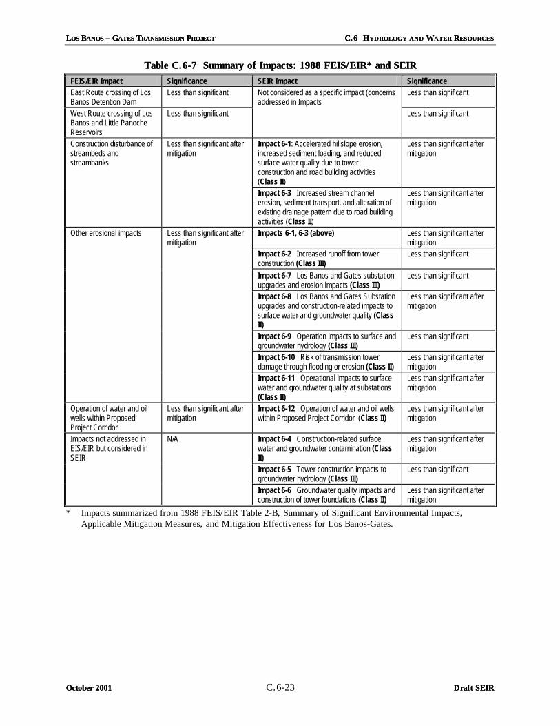
The FEIS/EIR document (TANC/WAPA, 1988) concluded that, with implementation of mitigation, the construction, operation, and maintenance of the proposed 500 kV transmission line project would not significantly impact water resources. Water quality impacts were primarily described as a result of construction-related disturbances. Impacts due to the construction of access roads at stream crossings and along steep hillslopes were identified as potentially the most severe. Such impacts could lead to significant erosion and sediment transport. Project operational impacts would be the continued erosion originally caused by the construction activity. These erosion impacts would require a long time for full recovery with the return of vegetative cover. Table C.6-7 presents the impacts identified in the 1988 FEIS/EIR, and shows how the previously identified impacts are evaluated in this SEIR.
LLOS OS BBANOS ANOS –– G GATES ATES TTRANSMISSION RANSMISSION PPROJECT ROJECT C.6 HC.6 HYDROLOGY AND YDROLOGY AND WWATER ATER RRESOURCESESOURCES
October 2001October 2001 C.6-23 Draft SEIRDraft SEIR
Table C.6Table C.6--7 Summary of Impacts: 1988 FEIS/EIR* and SEIR7 Summary of Impacts: 1988 FEIS/EIR* and SEIR
FEIS/EIR Impact Significance SEIR Impact Significance East Route crossing of Los Banos Detention Dam
Less than significant Less than significant
West Route crossing of Los Banos and Little Panoche Reservoirs
Less than significant
Not considered as a specific impact (concerns addressed in Impacts
Less than significant
Impact 6-1: Accelerated hillslope erosion, increased sediment loading, and reduced surface water quality due to tower construction and road building activities (Class II)
Less than significant after mitigation
Construction disturbance of streambeds and streambanks
Less than significant after mitigation
Impact 6-3 Increased stream channel erosion, sediment transport, and alteration of existing drainage pattern due to road building activities (Class II)
Less than significant after mitigation
Impacts 6-1, 6-3 (above) Less than significant after mitigation
Impact 6-2 Increased runoff from tower construction (Class III)
Less than significant
Impact 6-7 Los Banos and Gates substation upgrades and erosion impacts (Class III)
Less than significant
Impact 6-8 Los Banos and Gates Substation upgrades and construction-related impacts to surface water and groundwater quality (Class II)
Less than significant after mitigation
Impact 6-9 Operation impacts to surface and groundwater hydrology (Class III)
Less than significant
Impact 6-10 Risk of transmission tower damage through flooding or erosion (Class II)
Less than significant after mitigation
Other erosional impacts Less than significant after mitigation
Impact 6-11 Operational impacts to surface water and groundwater quality at substations (Class II)
Less than significant after mitigation
Operation of water and oil wells within Proposed Project Corridor
Less than significant after mitigation
Impact 6-12 Operation of water and oil wells within Proposed Project Corridor (Class II)
Less than significant after mitigation
Impact 6-4 Construction-related surface water and groundwater contamination (Class II)
Less than significant after mitigation
Impact 6-5 Tower construction impacts to groundwater hydrology (Class III)
Less than significant
Impacts not addressed in EIS/EIR but considered in SEIR
N/A
Impact 6-6 Groundwater quality impacts and construction of tower foundations (Class II)
Less than significant after mitigation
* Impacts summarized from 1988 FEIS/EIR Table 2-B, Summary of Significant Environmental Impacts, Applicable Mitigation Measures, and Mitigation Effectiveness for Los Banos-Gates.

C.6 HC.6 HYDROLOGY AND YDROLOGY AND WWATER ATER RRESOURCESESOURCES LLOS OS BBANOS ANOS –– G GAATES TES TTRANSMISSION RANSMISSION PPROJECTROJECT
Draft SEIRDraft SEIR C.6-24 October 2001October 2001
Table C.6-8 presents the mitigation measures from the 1988 FEIS/EIR and their disposition in this SEIR. All measures previously recommended have been incorporated into new mitigation measures; many of the older measures were vague and therefore would be difficult to enforce. The full text of the new mitigation measures recommended in this SEIR is presented in subsequent sections.
Table C.6Table C.6--8 Mitigation Measures from 1988 FEIS/EIR8 Mitigation Measures from 1988 FEIS/EIR Mitigation Measure from 1988 FEIS/EIR Disposition
Careful tower placement would avoid any potential adverse impacts to the following water features in the project area: existing and proposed reservoirs; groundwater wells; 100-year floodplains; intermittent streams; ponds; and local irrigation canals and ditches.
Incorporated into Mitigation Measures H-5, H-7, and H-9
PG&E will work with CDWR to site towers compatible with the existing facilities at Little Panoche Reservoir (West-5) or the proposed facilities at the Los Banos Grande Offstream Storage Project (West-3 and East).
Issue resulted in the creation of Alternative Segment 4A
For safety reasons, groundwater wells could not be located within the transmission line right-of-way. Therefore, wells would be avoided during final tower alignment plans. Wells that could not be avoided would be removed or relocated, and the owner would be compensated from the project Applicant.
Incorporated into Mitigation Measure H-12
Replant temporarily disturbed areas with a mixture of perennial grasses, forbs, brush, shrubs, and tree species that will provide effective erosion control. Prepare a firm, rough seedbed on fill or cut slopes and apply appropriate types and amounts of fertilizers and seed mixtures. Consider reseeding with native plants only in sensitive areas not subject to grazing.
Incorporated into Mitigation Measure H-1
Where possible, avoid road construction on very steep slopes to minimize surface erosion and slumping.
Incorporated into Mitigation Measures H-1 and H-2
Recontour, prepare the surface, and seed all roads, construction sites, and other disturbed areas not required for project operation and maintenance.
Incorporated into Mitigation Measure H-1
C.6.3.4C.6.3.4 ConstructionConstruction--Related Project ImpactsRelated Project Impacts
Following is a discussion of the types of impacts that could result from project construction. Mitigation measures for each impact are also presented. In Section C.6.3.6, project impacts are described by segment of the transmission line.
C.6.3.4.1C.6.3.4.1 Overhead Transmission LineOverhead Transmission Line
The principal component of the Proposed Project is the construction of a new 84-mile 500 kV overhead transmission line between PG&E’s Los Banos and Gates Substations. The line will consist of bundled aluminum conductors which are installed on self-supporting rectangular-base galvanized steel lattice structures. The lattice towers will vary in height from 100-160 feet. A cast-in-place concrete footing of about three feet in diameter and extends 10 to 15 feet below ground will support each tower leg. The span between towers will average 1,300 feet ranging from a minimum of 800 feet to a maximum of 1,500 feet.
Construction of the overhead line includes the following processes: surveying, clearing, determining access requirements, establishing construction facilities, foundation installation, tower assembly, conductor installation, and cleanup and removal of construction facilities (Section B.3.2). Approximately 350-400 towers will be constructed for the Proposed Project, although the actual site-specific locations within the proposed corridors are yet to be determined. Impacted areas will include the tower sites (0.23 acre per tower); conductor tensioning sites (0.9 acre at 3 to 5 mile

LLOS OS BBANOS ANOS –– G GATES ATES TTRANSMISSION RANSMISSION PPROJECT ROJECT C.6 HC.6 HYDROLOGY AND YDROLOGY AND WWATATER ER RRESOURCESESOURCES
October 2001October 2001 New New C.6-25 Draft SEIRDraft SEIR
intervals); conductor splicing sites (0.02 acre per 2 miles); construction yards (5.7 acres at 3 locations); work camps (2.0 acres at 2 sites); and new access roads (typically one mile of new road per one mile of transmission line) (see Table B-3 in Section B.3.1).
Impact 6Impact 6--1: Potential for Tower Construction and Road Building Activities to Accelerate Hillslope 1: Potential for Tower Construction and Road Building Activities to Accelerate Hillslope Erosion, Increase Sediment Loading to Local Channels, and ReduErosion, Increase Sediment Loading to Local Channels, and Reduce Surface Water Qualityce Surface Water Quality
During construction of the 500 kV transmission line, adverse surface water quality impacts due to sediment loading of excavated spoils could occur in creeks and wetlands adjacent to the construction area or immediately downstream. Tower and access road construction activities that include scraping, excavating, grading, backfilling, excess soil disposal, and topsoil handling and replacement are likely to generate sediment. In particular, excavation activities needed to prepare the concrete foundations for the towers will bring soil, sediment, rock, and perhaps water to the surface.
The potential for excavated spoils to enter the surface water drainage network is greatest near creek crossings and wetlands. The several intermittent and ephemeral streams crossed by the Proposed Project Corridor (Table C.6-1) could be impacted by sediment loading. In addition, identified wetlands along Salt Creek (Figure C.6-2) in the hillslope terrain near MP 9.0 could be adversely impacted by sediment loading from project construction. The potential for construction-related sediment and excavated spoils to enter the surface water drainage network represents a significant water quality impact. Additionally, this impact can have an accumulative effect of reducing the flood-carrying capacity of downstream channels.
State and county permitting requirements should ensure that this sediment loading impact is a less than significant impact. Construction-induced sediment and excavated spoils shall be managed in accordance with the requirements of the State Water Resources Control Board General NPDES Permit for stormwater runoff associated with construction activities (“general permit”). The State’s general permit outlines requirements for filing a Notice of Intent prior to construction, and for developing a Storm
Water Pollution Prevention Plan (SWPPP) that outlines “best management practices” to control discharges from the construction area.
To ensure that sedimentation and runoff are minimized, in compliance with the NPDES Permit, Mitigation Measure HH--11 requires that an Erosion Control Plan (ECP) be developed to compliment the SWPPP and prevent the runoff of construction-related and excavated materials into the drainage system. The ECP specified by Mitigation Measure HH--11 will be submitted to Merced and Fresno Counties along with grading permit applications. Implementation of the ECP will help stabilize graded areas and waterways, and reduce erosion and sedimentation, thus reducing this impact to less than significant levels (Class IIClass II).

C.6 HC.6 HYDROLOGY AND YDROLOGY AND WWATER ATER RRESOURCESESOURCES LLOS OS BBANOS ANOS –– G GATES ATES TTRANSMISSION RANSMISSION PPROJECTROJECT
Draft SEIRDraft SEIR New New C.6-26 October 2001October 2001
Mitigation Measure for Impact 6Mitigation Measure for Impact 6--1, Potential for Tower Construction and Road Building Activities to 1, Potential for Tower Construction and Road Building Activities to Accelerate Hillslope Erosion, Increase Sediment Loading to Local Channels, and Reduce Surface Accelerate Hillslope Erosion, Increase Sediment Loading to Local Channels, and Reduce Surface Water QualityWater Quality
HH--11 An erosion control and sediment transport control plan shall be submitted first to the CVRWQCB and CPUC for review and approval, and then to Merced and Fresno Counties along with grading permit applications. This plan shall be prepared in accordance with the standards provided in the Manual of Erosion and Sedimentation Control Measures (ABAG, 1981) and in compliance with practices recommended by the Natural Resources Conservation Service. Implementation of the plan will help stabilize graded areas and waterways, and reduce erosion and sedimentation. The plan shall be designed specifically for the hydrologic setting of the approved project, which includes upland slopes, tributary creeks, and larger streams.
The plan shall define the specific Best Management Practices (BMPs) that will be adhered to during construction activities. Erosion minimizing efforts such as hay bales, water bars, covers, sediment fences, sensitive area access restrictions (for example, flagging), vehicle mats in wet areas, and retention/ settlement ponds shall be installed before extensive clearing and grading begins. Mulching, seeding, or other suitable stabilization measures shall be used to protect exposed areas during construction activities. Revegetation plans, the design and location of retention ponds, and grading plans shall be submitted to the CDFG for review in the event of construction near waterways. In addition, PG&E shall:
• Replant temporarily disturbed areas with a mixture of perennial grasses, forbs, brush, shrubs, and tree species that will provide effective erosion control. Prepare a firm, rough seedbed on fill or cut slopes and apply appropriate types and amounts of fertilizers and seed mixtures. Consider reseeding with native plants only in sensitive areas not subject to grazing.
• Restore disturbed surfaces to original conditions, including reseeding or otherwise restoring vegetation on all disturbed slopes exceeding 2 percent, as soon as possible after such grading work is completed or later if approved by the Project Biologist. Recontour, prepare the surface, and seed all roads, construction sites, and other disturbed areas not required for project operation and maintenance.
• Use standard erosion practices and dust control measures, as defined in mitigation measures for air quality, during construction to protect biological and hydrological resources.
• Based on weather conditions as determined by the CPUC’s Environmental Monitor, Ttemporarily collect excavated or disturbed soil and place it in a controlled area surrounded by siltation fencing, hay bales, or a similarly effective erosion control technique that prevents the transport of sediment.
• Restrict the staging of construction materials, equipment, and excavation spoils to areas at least 100 feet outside of drainage channels or tributaries.
• Where tower or substation construction activities occur near a creek or channel, sediment containment methods shall be performed at least 100 feet from the channel.
• Upon completion of construction activities, excavated soil shall be replaced and graded to match the surroundings, and surplus soil shall be transported from the site and disposed of appropriately.
• Use existing roads for access wherever possible. Roads required for construction but not maintenance shall be removed after construction and surfaces restored to original conditions.
• Minimize steepness and unobstructed length of fill slopes. Protect newly constructed fill with appropriate materials to prevent erosion.
• Avoid road construction on very steep slopes and avoid work on unstable slopes and rock outcrops.
LLOS OS BBANOS ANOS –– G GATES ATES TTRANSMISSION RANSMISSION PPROJECT ROJECT C.6 HC.6 HYDROLOGY AND YDROLOGY AND WWATATER ER RRESOURCESESOURCES
October 2001October 2001 New New C.6-27 Draft SEIRDraft SEIR
• In agricultural areas where grading occurs, stockpile topsoil and replace after construction. Re-grade to original contours and re-seed in accordance with landowner objectives.
• Add soil amendments during revegetation to counteract potential chemical imbalances.
• Minimize use of heavy equipment on agricultural land.
Impact 6Impact 6--2: Increased Runoff from Tower Construction and Road Building Activities2: Increased Runoff from Tower Construction and Road Building Activities
Surface soil compaction and the reduction of available pore water space will occur as a result of scraping, grading, and other mechanized and vehicular traffic activities. This work will also remove the protective cover of vegetation, which acts as an important rainfall interceptor during storm events. The net result of increased compaction and reduced vegetation is a reduced infiltration capacity, which will generate greater surface runoff during precipitation events. This impact will be most severe at new road locations, tower locations, material lay-down areas, work camps, and at pull, tension, and splicing sites where construction activities are most intense. Construction and traffic activities occurring when the ground is wet or saturated will also increase the runoff potential.
The potential net increase in runoff due to increased impervious surfaces associated with new tower footings and the gravel road along the transmission line corridor is considered to be a less than significant impact because of the relatively small area impacted relative to the size of the overall drainage basins (Class IIIClass III), and no mitigation is required.
Impact 6Impact 6--3: Increased Stream Channel Erosion, Sediment Transport, and Alteration of the Existing 3: Increased Stream Channel Erosion, Sediment Transport, and Alteration of the Existing Drainage Pattern Due to Road Building and Construction ActivitiesDrainage Pattern Due to Road Building and Construction Activities
Although the overall increase in runoff due to increased impervious surfaces of roadway and other construction areas is probably not significant (as described above in Impact 6-2), the erosive impact of runoff becomes significant when this flow is concentrated at key locations. The generally northwest-southeast trending transmission line corridor crosses several intermittent and ephemeral streams which flow eastward out of the Diablo Range (Section C.6.1.1.1). Construction and road building activities across these stream valleys may alter existing surface runoff patterns such that more flow will be concentrated at particular stream crossings. This typically occurs when corrugated metal pipe culverts are used to convey flow beneath new access roads. Potential impacts of road construction and culvert emplacement include concentrating flow, which could increase stream erosion and sediment transport through channel incision. Besides gulleying effects, poorly designed stream crossings and culverts can negatively impact the existing drainage pattern through flow blockage or the redirection of tributary flow, also known as channel capture. The potential for concentrated runoff and increased erosion to result from road crossings of ephemeral streams and other construction activities is considered potentially significant (Class IIClass II) but mitigable to less than significant levels through the application of Mitigation Measures HH--11 (above) and HH--22, following.
Mitigation Measure for Impact 6Mitigation Measure for Impact 6--3, Road Building and Construction Activities3, Road Building and Construction Activities
HH--22 Access roads shall be designed to account for anticipated surface runoff and channel flow. Culverts designed to convey flow beneath access roads shall be designed for the specific
C.6 HC.6 HYDROLOGY AND YDROLOGY AND WWATER ATER RRESOURCESESOURCES LLOS OS BBANOS ANOS –– G GATES ATES TTRANSMISSION RANSMISSION PPROJECTROJECT
Draft SEIRDraft SEIR New New C.6-28 October 2001October 2001
hydrologic and hydraulic conditions occurring at the site. Culvert design should follow standard practices (Caltrans Highway Design Manual, 1999) and should also include energy dissipation practices (Federal Highway Administration, 1983). It is important that flow velocities are maintained below levels that are capable of causing channel erosion downstream or headward channel incision upstream. PG&E shall submit copies of approved grading and construction plans for new roads Construction plans for new roads shall be submitted to the CPUC for review and approval prior to the start of project construction.
Impact 6Impact 6--4: Surface Water and Groundwater Contamination During Construction 4: Surface Water and Groundwater Contamination During Construction
Construction of the proposed transmission line would require the use of a variety of motorized heavy equipment, including trucks, cranes, dozers, air compressors, graders, backhoes, and drill rigs. This equipment requires job site replenishment of hazardous chemicals in the form of fuels, oils, grease, coolants, and other fluids. The accidental spill of these, or other, construction-related materials could lead to the discharge of contaminants into the drainage system. Conveyance of contaminants could take place directly at the time of the spill. Alternatively, the contaminants could be held in place until a runoff event delivered them to a watercourse later or they could infiltrate into the soil and groundwater below. A chemical spill affecting a stream channel, wetland area, or groundwater reserve would be a significant impact. However, various permitting conditions and Mitigation Measures HH--33 and HH--44 would reduce the impact of spilled and transported contaminants to a less than significant level (Class IIClass II).
In addition to permitting conditions described above in Impact 6-1, the Applicant will develop BMPs to prevent contamination as part of the requirements for a National Pollutant Discharge Elimination System (NPDES) permit by the State Water Resources Control Board. BMPs shall be approved by the CPUC, Regional Water Quality Control Board, and affected public agencies prior to permit issuance. They will be modified as necessary during construction to minimize the possibility of contaminated discharge into surface waters. Any spill occurring during construction activities shall be contained and immediately cleaned up.
Mitigation Measures HH--33 and HH--44 require development of a training program and hazardous substance control plan to prevent contaminated water from exiting the construction site and entering into the drainage or groundwater system.
Mitigation Measures for Impact 6Mitigation Measures for Impact 6--4, Su4, Surface Water and Groundwater Contamination During rface Water and Groundwater Contamination During Construction Construction
HH--33 An environmental training program shall be established by PG&E to communicate environmental concerns and appropriate work practices, including spill prevention and response measures, to all field personnel. This training program shall not only describe general environmental concerns and procedures but shall emphasize site-specific physical conditions to improve hazard prevention. For example, all flow paths to the nearest water bodies should be identified to workers and where hazardous materials may specifically impact the site shall be identified. An outline of the training program and monitoring plan shall be submitted to the CPUC for review and approval prior to the start of construction.

LLOS OS BBANOS ANOS –– G GATES ATES TTRANSMISSION RANSMISSION PPROJECT ROJECT C.6 HC.6 HYDROLOGY AND YDROLOGY AND WWATATER ER RRESOURCESESOURCES
October 2001October 2001 New New C.6-29 Draft SEIRDraft SEIR
HH--44 A Hazardous Substance Control and Emergency Response Plan (HSCERP) shall be prepared by PG&E and submitted to the CPUC for review and approval. The plan shall include preparations for quick and safe cleanup of accidental spills occurring during construction. This plan will be submitted with the grading permit application. It will prescribe hazardous materials handling procedures for reducing the potential for a spill during construction, and will include an emergency response program to ensure quick and safe cleanup of accidental spills. More specifically, the plan will identify areas where refueling and vehicle maintenance activities and storage of hazardous materials, if any, will be permitted. The plan shall include the following:
• All refueling, lubrication, and other machinery or vehicular maintenance activities shall be performed at least 150 feet from any tributary, stream channel, aqueduct or canal. This distance is increased to 500 feet when in the vicinity of identified vernal pool wetlands, or the Los Banos and Little Panoche Reservoirs.
• Oil-absorbent material, tarps, and storage drums to contain and control any minor releases of transformer oil shall be used.
• Describe the clean-up process if excess water and liquid concrete escapes from tower foundations during pouring. This excess will be directed to bermed areas adjacent to the borings where the water will infiltrate or evaporate and the concrete will remain and begin to set. Once the excess concrete has been allowed to set up (but before it is dry), it will be removed and transported to an approved landfill for disposal.
Impact 6Impact 6--5: Tower Foundation Impacts to Groundwater Hydrology 5: Tower Foundation Impacts to Groundwater Hydrology
The foundation of each lattice tower will require digging four holes that will be filled with steel and concrete. Each hole is about 3 feet in diameter and about 10-15 feet deep. Depth to groundwater in the hillslope terrain of the Proposed Western Corridor is generally considered to be deeper than the base of the tower foundations. Shallower groundwater elevations are more typically observed east of the Proposed Western Corridor (Figures C.6-1a and C.6-1b). As such, from a regional perspective there is no appreciable impact to groundwater hydrology along the Western Corridor. However, specific tower locations may occur in areas where groundwater is shallower.
Since the footprint of each foundation is quite small relative to the size of the regional groundwater reservoirs, impacts to groundwater hydrology are considered to be less than significant (Class IIIClass III). Although not expected along the Western Corridor with its deeper groundwater levels, if digging of the tower foundation holes does contact groundwater, the construction team may be required to pump groundwater to dewater the excavation. If this occurs, pumped groundwater would be disposed of according to the SWPPP. Although minor short-term localized changes (e.g., drawdown) in groundwater flow could occur as a result of dewatering during drilled pier construction, impacts would be temporary and less than significant (Class IIIClass III).
Impact 6Impact 6--6: Tower Foundation Impacts to Groundwater Quality 6: Tower Foundation Impacts to Groundwater Quality
Groundwater quality in the project area could be significantly impacted if borings and tower foundations penetrated areas with pre-existing impaired soil or water quality conditions. Construction activities could thereby create a cross-contamination between polluted layers and other (deeper or shallower) non-polluted groundwater zones. The Applicant states that it does not have information on ocations with potentially impaired or contaminated soil or groundwater resources. This issue is more

C.6 HC.6 HYDROLOGY AND YDROLOGY AND WWATER ATER RRESOURCESESOURCES LLOS OS BBANOS ANOS –– G GATES ATES TTRANSMISSION RANSMISSION PPROJECTROJECT
Draft SEIRDraft SEIR New New C.6-30 October 2001October 2001
important in the southern project area (Segment 6) near Coalinga where there are numerous oil wells, pipelines, and tanks, as well as a waste disposal site. Therefore, Mitigation Measure HH--55 seeks to address the potential for groundwater contamination by requiring an investigation of soil and groundwater quality conditions through available informational sources, as well as requiring a field testing program in conjunction with finalizing the Proposed Western Corridor. Implementation of Mitigation Measure HH--55 would reduce this impact to less than significant levels (Class IIClass II).
Mitigation Measure for Impact 6Mitigation Measure for Impact 6--6, Tower Foundation Impacts 6, Tower Foundation Impacts
HH--55 Prior to final tower siting, PG&E shall research existing information about the project corridor to identify and avoid areas with potential existing soil and groundwater contamination (where groundwater is shallower than 20 feet). Findings regarding soil and groundwater contamination conditions shall be supplied to the CPUC in coordination with the agency review of the specific alignment and tower locations for the selected transmission line corridor.
Before construction begins along the approved alignment, soil sampling and potholing shall be conducted south of project milepost MP 66 (as shown on Figure B-1b) at representative intervals, and soil information shall be provided to construction crews to inform them about soil conditions and potential hazards that were not identified in the records searches performed prior to tower siting. If hazardous materials are encountered in either soils or groundwater, work shall be stopped until the material is properly characterized and appropriate measures are taken to protect human health and the environment. If excavation of hazardous materials is required, they shall be handled, transported, and disposed of in accordance with federal, state, and local regulations.
In contrast to the condition described above where impaired soil or groundwater could be contacted during construction, soil and groundwater resources that are not currently impaired could also be significantly impacted if surface contaminants, either from soil or construction-related fuels and materials, were to invade excavations that had bored into shallow groundwater bodies. This is similar to Impact 6-4 described above, but would occur in the tower footings rather than at the surface. State and county permitting requirements and the application of Mitigation Measures HH--11, HH--33, and HH--44 would reduce potential impacts to a less than significant level (Class IIClass II).
C.6.3.4.2C.6.3.4.2 Los Banos, Gates, and Midway Substation UpgradesLos Banos, Gates, and Midway Substation Upgrades
Upgrades to the Los Banos and Gates Substations involve establishing new concrete footings and slabs to accommodate new transformer banks, circuit switches, and cable termination stations. In addition, there is need to install new series capacitors to facilitate changes in other hook-ups, and other improvements related to relays and circuits. All of these upgrades will occur within the footprints and fence lines of the existing substations.
Impact 6Impact 6--7: Erosion and Sediment Transport at Los Banos and Gates Substations7: Erosion and Sediment Transport at Los Banos and Gates Substations
Potential construction-related erosion and sediment transport impacts at the Los Banos and Gates Substation sites are considered to be less than significant due to the limited scale of construction at these substations. The application of an Erosion Control Plan, specialized on-site training, and a Hazardous

LLOS OS BBANOS ANOS –– G GATES ATES TTRANSMISSION RANSMISSION PPROJECT ROJECT C.6 HC.6 HYDROLOGY AND YDROLOGY AND WWATATER ER RRESOURCESESOURCES
October 2001October 2001 New New C.6-31 Draft SEIRDraft SEIR
Materials Plan as described above in Mitigation Measures HH--11, HH--33, and HH--44 will ensure that these impacts remain less than significant (Class IIIClass III).
Impact 6Impact 6--8: Surface and Groundwater Quality Impacts at Los Banos and Gates Substations8: Surface and Groundwater Quality Impacts at Los Banos and Gates Substations
Potential construction-related impacts to surface water and groundwater quality at the Los Banos and Gates Substation sites would occur mostly from contamination through the spill of fuels and other fluids. This impact is very similar to Impact 6-4 described above for the construction of the overhead transmission lines. Potential construction impacts to surface water and ground water quality would be reduced to a less than significant level (Class IIClass II) through the application of Mitigation Measures HH--11, HH--33, HH--44, and HH--5 5 as described above.
C.6.3.4.3C.6.3.4.3 GatesGates--ArcoArco--Midway Reconductoring and Gates LoopMidway Reconductoring and Gates Loop
Two additional project elements involve the potential reconductoring or reconfiguration of the existing Gates-Arco-Midway transmission line south of the Gates Substation and realigning of portions (7,000 feet) of the Los Banos-Midway No. 2 route at the Gates Substation (Gates Loop). The Gates Loop realignment will involve the removal of 7 existing towers and the construction of 6 new towers adjacent to the existing Los Banos-Midway No. 1 line. The pulling and tensioning construction activities for the reconductoring process are similar to those same activities when constructing a new transmission line. Likewise, the tower and alignment changes for the Gates Loop component of the project does not require any additional types of construction activities beyond what is required for the construction of the proposed transmission line. As such, the construction impacts associated with the Gates-Arco-Midway reconductoring and Gates Loop are very similar to Impacts 6-1 through 6-6 described above. These impacts would be reduced to less than significant levels (Class IIClass II) through the application of Mitigation Measures HH--11 throughthrough HH--55.
C.6.3.5 C.6.3.5 Project Maintenance and Operational ImpactsProject Maintenance and Operational Impacts
Impact 6Impact 6--9: Operational Impacts to Surfac9: Operational Impacts to Surface and Groundwater Hydrology at Tower and Substation e and Groundwater Hydrology at Tower and Substation LocationsLocations
At each tower site, a concrete foundation approximately 3 feet in diameter and up to 15 feet deep will be constructed. Placement of this impervious material restricts storm water infiltration. However, this impact is considered to be less than significant (Class IIIClass III) because the total area impacted by tower foundations is small. This issue was also addressed above in Impact 6-2 for towers outside of substation areas. Since the modifications to the Los Banos and Gates Substations will occur within the existing footprint of the substation, no significant impacts to hydrology are expected.
Impact 6Impact 6--10: Risk of Transmission Tower Damage Through Flooding or Erosion 10: Risk of Transmission Tower Damage Through Flooding or Erosion
As indicated in the description of significance criteria above, a significant impact would occur if project transmission towers were subjected to a substantial risk of damage through flooding or erosion through the exposure of tower foundations to running water. Additionally, if flooding or stream erosion in the project area resulted in significant damage to access roads/bridges or to other structures related to the

C.6 HC.6 HYDROLOGY AND YDROLOGY AND WWATER ATER RRESOURCESESOURCES LLOS OS BBANOS ANOS –– G GATES ATES TTRANSMISSION RANSMISSION PPROJECTROJECT
Draft SEIRDraft SEIR New New C.6-32 October 2001October 2001
Proposed Project, this would also be considered a significant impact. As described above, most of the project area is zoned as regions outside of the 500-year flood zone. However, there are certain creeks whose adjacent floodplains have been designated as 100-years flood zones. This is more applicable along the Eastern Corridor Alternative. Impact 6-10 would be reduced to a less than significant level (Class IIClass II) by the implementation of Mitigation Measure HH--66.
Mitigation Measure for Impact 6Mitigation Measure for Impact 6--10, Risk of Transmission Tower Damage Through Flooding or Erosion10, Risk of Transmission Tower Damage Through Flooding or Erosion
HH--66 Transmission towers shall not be sited within a distance of 200 feet from the edge of stream channelsa designated 100-year floodplain. Prior to final alignment of transmission towers, the Applicant shall evaluate the position of all towers in light of the most recent (July 2001 or later) floodplain delineations in the project area. To demonstrate compliance, PG&E shall provide the CPUC with a map of towers locations relative to stream courses within 100 feet of identified floodplains 30 days prior to the start of construction.
Impact 6Impact 6--11: Operational Impacts to Sur11: Operational Impacts to Surface and Groundwater Quality at Substationsface and Groundwater Quality at Substations
Future operation of the new equipment in the modified areas of the Los Banos, Gates, and Midway Substations could result in the release of fuels and oil thereby creating a significant surface water quality impact (Class IIClass II). In particular, the release of mineral oil from oil-filled electrical equipment, either from slow leaks or catastrophic failure, could wash into adjacent drainages or infiltrate into the water table.
The Federal Clean Water Act and the State Porter-Cologne Water Quality Control Act prohibit the release of any oil to waters of the state. The use of oil-absorbent material, tarps, and storage drums will be used to contain and control any minor releases of transformer oil to the site as described in Mitigation Measure HH--44. Spills that may occur during project operation shall be controlled through the implementation of a Spill Prevention Containment and Countermeasure (SPCC) pond as specified in Mitigation Measure HH--77 below. Existing SPCC plans for the Los Banos, Gates, and Midway Substations will need to be revised to include the new equipment and the expanded area of the substations. Incorporation of SPCC measures into the project design would reduce impacts to a less than significant level (Class IIClass II).
Mitigation Measure for Impact 6Mitigation Measure for Impact 6--11, Operational Impacts to Surface and Groundwater Quality at 11, Operational Impacts to Surface and Groundwater Quality at SubstationsSubstations
HH--77 If PG&E currently has a spill prevention containment and countermeasure (SPCC) pond that collects runoff from the Los Banos, Gates, and Midway Substations, the pond shall be upgraded to accommodate additional flow resulting from the substation modifications. If there is currently no SPCC pond at these substation sites, PG&E shall update its SPCC plan to explain how the additional runoff or potential releases would be accommodated within the substations. PG&E shall submit the updated SPCC to the CPUC for review and approval 30 days prior to energizing the new lines or the new portion of the substations.

LLOS OS BBANOS ANOS –– G GATES ATES TTRANSMISSION RANSMISSION PPROJECT ROJECT C.6 HC.6 HYDROLOGY AND YDROLOGY AND WWATER ATER RRESOURCESESOURCES
October 2001October 2001 C.6-33 Draft SEIRDraft SEIR
Impact 6Impact 6--12: Conflict with Operation of Water and Oil Wells Within the Transmission Corridor12: Conflict with Operation of Water and Oil Wells Within the Transmission Corridor
One of the mitigation measures from 1986 Draft EIS/EIR (see Table C.6-7) states that for safety reasons, groundwater wells will not be located within the transmission line right-of-way (ROW). In addition, as stated in the Project Description regarding ROW acquisition, wells may not be placed in the easement of the transmission line corridor. In the southern project area there are many oil wells in addition to the presence of groundwater wells. The operation, maintenance, and repair of oil wells beneath a transmission line poses a similar risk as described previously for groundwater wells, and therefore presents a potentially significant impact (Class IIClass II). The application of Mitigation Measure HH--88 would reduce this impact to a less than significant level.
Mitigation MeMitigation Measure for Impact 6asure for Impact 6--12, Conflict with Operation of Water and Oil Wells Within the 12, Conflict with Operation of Water and Oil Wells Within the Transmission CorridorTransmission Corridor
HH--88 The final tower siting for the approved project shall avoid existing oil and water wells. Wells that cannot be avoided shall be removed or relocated, and the owner shall be compensated by the Applicant. To demonstrate compliance, at least 30 days prior to construction, PG&E shall provide a map showing all oil and water wells within 200 feet of the edge of the ROW.
C.6.3.6C.6.3.6 Tower Siting Considerations Tower Siting Considerations and Specific Segment Impactsand Specific Segment Impacts
C.6.3.6.1C.6.3.6.1 Segment 1Segment 1
The 1.9-mile route of Segment 1 between the Los Banos Substation and MP 1.9 does not involve any additional segment specific impacts that are not already addressed by Impacts 6-1 through 6-12 as described above.
C.6.3.6.2C.6.3.6.2 Segment 2Segment 2
The 12.7-mile route of Segment 2 (MP 1.9 to MP14.6) crosses the upstream reach of the Los Banos Reservoir (MP 6.0), Salt Creek, Merced Co. (MP 9.0), and Ortigalita Creek (MP 13.5). Based on topographic maps of the project area, it is presumed that towers along the Proposed Western Corridor would be located on ridges or bluffs north and south of the reservoir and would not therefore immediately impact reservoir or its shoreline area. Impacts to identified wetlands along Salt Creek and Ortigalita Creek (Figure C.6-2) are potentially more significant. Impacts and mitigation measures described above in relation to construction-related sediment loading and contamination would also be applied in Segment 2 to mitigate any potentially significant impacts. Mitigation Measure HH--44 is particularly important and specifically applies to this segment.
C.6.3.6.3C.6.3.6.3 Segment 3Segment 3
Segment 3 (MP 14.6 to MP 20.5) traverses rugged hillslope terrain consisting of steep slopes and valleys. Based on a similar transmission line project on steep terrain (CPUC, 2000), the Applicant will presumably be siting tower locations on ridge locations and utilize valleys for the transmission line sag. Therefore, in Segment 3, access and potential road building activities to reach ridge tops will occur. As such, the construction impacts and mitigation measures previously described above will apply to

C.6 HC.6 HYDROLOGY AND YDROLOGY AND WWATER ATER RRESOURCESESOURCES LLOS OS BBANOS ANOS –– G GAATES TES TTRANSMISSION RANSMISSION PPROJECTROJECT
Draft SEIRDraft SEIR C.6-34 October 2001October 2001
Segment 3. In particular, Impacts 6-1 and 6-3, and their respective Mitigation Measures HH--11 and HH--22, should be implemented along Segment 3.
C.6.3.6.4C.6.3.6.4 Segment 4Segment 4
The key water resources issue of Segment 4 (MP 20.4 to MP 28.9) is that the Proposed Western Corridor crosses immediately east of the Little Panoche Dam. However, the construction of towers in the vicinity of the dam should not generate additional impacts beyond what is addressed above in Impacts 6-1 through 6-11. Mitigation Measure HH--44 specifically requires that all fueling activities occur at least 500 feet from the Little Panoche Reservoir.
C.6.3.6.5C.6.3.6.5 SegmeSegment 5nt 5
Several intermittent and ephemeral streams are crossed by the Proposed Western Corridor through Segment 5 (MP 28.9 to MP 68.9). These streams include the named Panoche Creek, Tumey Gulch, Arroyo Ciervo, Arroyo Hondo, Cantua Creek, Salt Creek (Fresno Co.), Martinez Creek, and Domengine Creek (Table C.6-1). Impacts and their associated mitigation measures described above in relation to construction-related sediment loading and contamination would also be applied in Segment 5 to mitigate any potentially significant impacts. Mitigation Measure HH--44 is particularly important because it would prevent contamination of waterways by construction fuels.
C.6.3.6.6C.6.3.6.6 Segment 6Segment 6
According to the Project Description (Section B.2), the Western Corridor through Segment 6 in the Coalinga area (MP 68.9 to MP 79.2) would avoid oil wells, oil fields, and water extraction wells, but would cross a few evaporation ponds associated with oil operations. These siting considerations are consistent with Mitigation Measure HH--99, which prevents the presence of operable oil or water wells within the transmission line corridor. Another concern in Segment 6 is that even if the corridor alignment avoids oil and water well locations, there may be existing contaminants in the soil either from past well operations or the migration of contaminants from an adjacent area. The information gained from the application of Mitigation Measure HH--5 5 would reduce the potential impact to surface water and groundwater quality to a less than significant level (Class IIClass II).
C.6.3.6.7C.6.3.6.7 Segment 7Segment 7
Section 7 is the final 4-mile eastern connection to the Gates Substation. Segment 7 does not involve any additional segment specific impacts that are not already addressed by general Impacts 6-1 through 6-11. The presence of shallow groundwater (Impact 6-5) may be more likely in moving east into the Central Valley terrain, but data from wells installed between 1988-1999 did not indicate the presence of shallow groundwater along Segment 7 of the Western Corridor (Figure C.6-1b).

LLOS OS BBANOS ANOS –– G GATES ATES TTRANSMISSION RANSMISSION PPROJECT ROJECT C.6 HC.6 HYDROLOGY AND YDROLOGY AND WWATER ATER RRESOURCESESOURCES
October 2001October 2001 C.6-35 Draft SEIRDraft SEIR
C.6.4C.6.4 EENVIRONMENTAL NVIRONMENTAL IIMPACTS AND MPACTS AND MMITIGATION ITIGATION MMEASURES FOR EASURES FOR WWESTERN ESTERN CCORRIDOR ORRIDOR AALTERNATIVE LTERNATIVE SSEGMENTSEGMENTS
C.6.4.1C.6.4.1 Segment 2ASegment 2A
Alternative Segment 2A has a more westerly alignment, compared to Proposed Segment 2, such that the Alternative Segment 2A corridor would pass west of the Los Banos reservoir. The Alternative Segment 2A corridor would still require a crossing of Los Banos Creek, but this would occur at a steep valley just upstream of the reservoir. Alternative Segment 2A does not involve any additional specific impacts that are not already addressed above in the descriptions of Impacts 6-1 through 6-11 or the concerns mentioned for Proposed Segment 2.
C.6.4.2C.6.4.2 Segment 4ASegment 4A
The alignment adjustment made for Alternative Segment 4A is done with the same objective as that of Alternative Segment 2A, to avoid crossing a reservoir. In the case of Alternative Segment 4A, the Little Panoche Reservoir is avoided by maintaining a more westerly route that is upstream of the reservoir. Based on review of topographic maps, the siting of towers along Alternative Segment 4A upstream of the reservoir will likely require a tower installed on the valley bottom north of Little Panoche Creek. In this location, Mitigation Measure HH--7 7 should be applied such that transmission towers in the Little Panoche Creek valley are not sited within 100-year floodplains. The application of Mitigation Measure HH--66 would reduce the potential risk of tower damage through flooding or erosion (Impact 6-10) to a less than significant level (Class IIClass II).
C.6.4.3C.6.4.3 Segment 6ASegment 6A
Alternative Segment 6A is east of Proposed Segment 6 and would involve crossing fewer oil operation areas and more agricultural areas than the Proposed Segment 6 in the Coalinga area. Impact 6-6 is still appropriate for Alternative Segment 6A and would require the application of Mitigation Measures HH--44 and HH--55 to reduce this impact to a less than significant level (Class IIClass II). However, the more eastern alignment of Alternative Segment 6A would likely reduce the possibility of encountering contaminated soil or water from oil operations.
C.6.4.4C.6.4.4 Segment 6BSegment 6B
Alternative Segment 6B is located west of Proposed Segment 6 and passes through areas with several oil and water wells. Due to this alignment, Impacts 6-6, 6-11, and 6-12 are more likely to be more severe with Alternative Segment 6B. In fact, Impact 6-12 (conflict with oil or water wells) is potentially unmitigable due to the large number of wells in this alternative segment. If, as required by Mitigation Measure HH--88, a route cannot be selected that does not pass though oil or water well areas, then Impact 6-12 may remain significant (Class IClass I).

C.6 HC.6 HYDROLOGY AND YDROLOGY AND WWATER ATER RRESOURCESESOURCES LLOS OS BBANOS ANOS –– G GAATES TES TTRANSMISSION RANSMISSION PPROJECTROJECT
Draft SEIRDraft SEIR C.6-36 October 2001October 2001
C.6.5C.6.5 EENVIRONMENTAL NVIRONMENTAL IIMPACTS AND MPACTS AND MMITIGATION ITIGATION MMEASURES FOR THE EASURES FOR THE EEASTERN ASTERN CCORRIDOR ORRIDOR AALTERNATIVELTERNATIVE
Overall project impacts described above (Impacts 6-1 through 6-12) and associated Mitigation Measures HH--1 through H1 through H--88 would also apply to the Eastern Corridor Alternative. The key hydrologic difference between the Proposed Western and Alternative Eastern Corridors relates to their different physiographic positions. As described above, the Western Corridor is located in the more rugged hillslope and transitional alluvial fan terrain while the Eastern Corridor Alternative is in the flatter terrain of the Central Valley proper. Thus, potential construction-related erosion and sediment transport (Impacts 6-1 and 6-3) are likely to be greater in the steeper slopes of the Western Corridor than along the flatter valley of the Eastern Corridor Alternative. However, along the Eastern Corridor Alternative, the potential for contacting shallow groundwater is greater (Impacts 6-5 and 6-6, Figures C.6-1a and C.6-1b). As for the Western Corridor, Impact 6-6 along the Eastern Corridor Alternative would be reduced to less than significant levels through the application of Mitigation Measure HH--55.
Segment 1 of the Eastern Corridor Alternative does not involve any different impacts than Segment 1 of the Western Corridor. In Segment 2, unlike the Western Corridor, the Eastern Corridor Alternative would not cross the Los Banos Reservoir, but would pass just east of the dam. In Segment 3 and the northern portion of Segment 4, the Eastern Corridor Alternative would be very near to the California Aqueduct in places. Mitigation Measure HH--44, which specifies that all refueling, lubrication, and other vehicle or machine maintenance activities should occur at least 150 feet from the aqueduct, should be implemented in this segment. The southern portion of the Eastern Corridor Alternative (Segments 5 and 6) does not involve any additional specific impacts or require additional mitigation measures.
C.6.6C.6.6 MMITIGATION ITIGATION MMONITORINGONITORING, C, COMPLIANCEOMPLIANCE, , AND AND RREPORTING EPORTING TTABLEABLE
Table C.6-9 on the following page presents the Mitigation Monitoring Program for the hydrology and water resources issue area. Measures from the original EIR, as seen in Table C.6-8, were incorporated into the current mitigation measures. In general, the previous measures, which were often very general, were expanded to offer more specific procedures to address the identified impacts.

LLOS OS BBANOS ANOS –– G GATES ATES TTRANSMISSION RANSMISSION PPROJECT ROJECT C.6 HC.6 HYDROLOGY AND YDROLOGY AND WWATER ATER RRESOURCESESOURCES
October 2001October 2001 New New C.6-37 Draft SEIRDraft SEIR
Table C.6Table C.6--9 Mitigation Monitoring Program9 Mitigation Monitoring Program
Impact (Class) Mitigation Measure Location Monitoring/Reporting Action Effectiveness Criteria Responsible Agency Timing
6-1 Accelerated hillslope erosion, increased sediment loading, and reduced surface water quality due to tower construction and road building activities (Class II)
H-1 An erosion control and sediment transport control plan shall be submitted first to the CVRWQCB and CPUC for review and approval, and then to Merced and Fresno Counties along with grading permit applications. This plan shall be prepared in accordance with the standards provided in the Manual of Erosion and Sedimentation Control Measures (ABAG, 1981) and in compliance with practices recommended by the Natural Resources Conservation Service. Implementation of the plan will help stabilize graded areas and waterways, and reduce erosion and sedimentation. The plan shall be designed specifically for the hydrologic setting of the approved project, which includes upland slopes, tributary creeks, and larger streams. The plan shall define the specific Best Management Practices (BMPs) that will be adhered to during construction activities. Erosion minimizing efforts such as hay bales, water bars, covers, sediment fences, sensitive area access restrictions (for example, flagging), vehicle mats in wet areas, and retention/ settlement ponds shall be installed before extensive clearing and grading begins. Mulching, seeding, or other suitable stabilization measures shall be used to protect exposed areas during construction activities. Revegetation plans, the design and location of retention ponds, and grading plans shall be submitted to the CDFG for review in the event of construction near waterways. In addition, PG&E shall:
• Replant temporarily disturbed areas with a mixture of perennial grasses, forbs, brush, shrubs, and tree species that will provide effective erosion control. Prepare a firm, rough seedbed on fill or cut slopes and apply appropriate types and amounts of fertilizers and seed mixtures. Consider reseeding with native plants only in sensitive areas not subject to grazing.
All Proposed and Alternative construction sites
CPUC to review construction plans, monitor construction.
Compliance with Best Management Practices, SWPPP, and ECP. Permits issued; inspections during construction show no significant impacts. Construction-related sediment is prevented from reaching drainage network.
Merced County Dept. Public Works Fresno County Dept. Public Works USACOE CDFG SWRCB CVRWQCB CPUC
Review plans and permits prior to construction, inspect during construction.
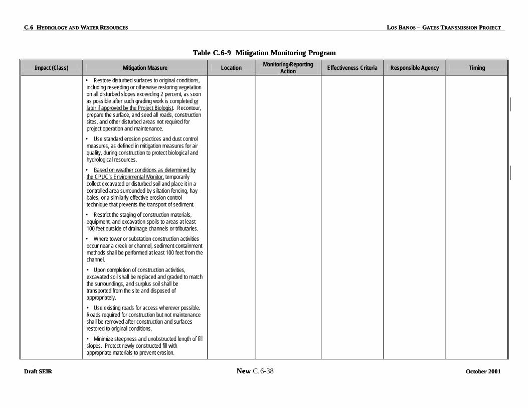
C.6 HC.6 HYDROLOGY AND YDROLOGY AND WWATER ATER RRESOURCESESOURCES LLOS OS BBANOS ANOS –– G GATES ATES TTRANSMISSION RANSMISSION PPROJECTROJECT
Draft SEIRDraft SEIR New New C.6-38 October 20October 200101
Table C.6Table C.6--9 Mitigation Monitoring Program9 Mitigation Monitoring Program
Impact (Class) Mitigation Measure Location Monitoring/Reporting Action Effectiveness Criteria Responsible Agency Timing
• Restore disturbed surfaces to original conditions, including reseeding or otherwise restoring vegetation on all disturbed slopes exceeding 2 percent, as soon as possible after such grading work is completed or later if approved by the Project Biologist. Recontour, prepare the surface, and seed all roads, construction sites, and other disturbed areas not required for project operation and maintenance.
• Use standard erosion practices and dust control measures, as defined in mitigation measures for air quality, during construction to protect biological and hydrological resources.
• Based on weather conditions as determined by the CPUC’s Environmental Monitor, temporarily collect excavated or disturbed soil and place it in a controlled area surrounded by siltation fencing, hay bales, or a similarly effective erosion control technique that prevents the transport of sediment.
• Restrict the staging of construction materials, equipment, and excavation spoils to areas at least 100 feet outside of drainage channels or tributaries.
• Where tower or substation construction activities occur near a creek or channel, sediment containment methods shall be performed at least 100 feet from the channel.
• Upon completion of construction activities, excavated soil shall be replaced and graded to match the surroundings, and surplus soil shall be transported from the site and disposed of appropriately.
• Use existing roads for access wherever possible. Roads required for construction but not maintenance shall be removed after construction and surfaces restored to original conditions.
• Minimize steepness and unobstructed length of fill slopes. Protect newly constructed fill with appropriate materials to prevent erosion.

LLOS OS BBANOS ANOS –– G GATES ATES TTRANSMISSION RANSMISSION PPROJECT ROJECT C.6 HC.6 HYDROLOGY AND YDROLOGY AND WWATER ATER RRESOURCESESOURCES
October 2001October 2001 New New C.6-39 Draft SEIRDraft SEIR
Table C.6Table C.6--9 Mitigation Monitoring Program9 Mitigation Monitoring Program
Impact (Class) Mitigation Measure Location Monitoring/Reporting Action Effectiveness Criteria Responsible Agency Timing
• Avoid road construction on very steep slopes and avoid work on unstable slopes and rock outcrops.
• In agricultural areas where grading occurs, stockpile topsoil and replace after construction. Re-grade to original contours and re-seed in accordance with landowner objectives.
• Add soil amendments during revegetation to counteract potential chemical imbalances.
• Minimize use of heavy equipment on agricultural land.
6-3 Increased stream channel erosion, sediment transport, and alteration of existing drainage pattern due to road building activities (Class II)
H-2 Access roads shall be designed to account for anticipated surface runoff and channel flow. Culverts designed to convey flow beneath access roads shall be designed for the specific hydrologic and hydraulic conditions occurring at the site. Culvert design should follow standard practices (Caltrans Highway Design Manual, 1999) and should also include energy dissipation practices (Federal Highway Administration, 1983). It is important that flow velocities are maintained below levels that are capable of causing channel erosion downstream or headward channel incision upstream. PG&E shall submit copies of approved grading and construction plans for new roads Construction plans for new roads shall be submitted to the CPUC for review and approval prior to the start of project construction.
All Proposed road building locations
CPUC to review road and culvert design, construction, operation, and maintenance plan; monitor construction.
Compliance with approved plan. Flow networks of existing streams and drainage channels are not extensively altered. Channel erosion is not initiated as a result of construction activities
Merced County Dept. Public Works Fresno County Dept. Public Works USACOE CVRWQCB CDFG CPUC
Review design and construction plans prior to construction, inspect during construction.

C.6 HC.6 HYDROLOGY AND YDROLOGY AND WWATER ATER RRESOURCESESOURCES LLOS OS BBANOS ANOS –– G GATES ATES TTRANSMISSION RANSMISSION PPROJECTROJECT
Draft SEIRDraft SEIR New New C.6-40 October 20October 200101
Table C.6Table C.6--9 Mitigation Monitoring Program9 Mitigation Monitoring Program
Impact (Class) Mitigation Measure Location Monitoring/Reporting Action Effectiveness Criteria Responsible Agency Timing
6-4 Construction-related surface water and groundwater contamination (Class II)
H-3 An environmental training program shall be established by PG&E to communicate environmental concerns and appropriate work practices, including spill prevention and response measures, to all field personnel. This training program shall not only describe general environmental concerns and procedures but shall emphasize site-specific physical conditions to improve hazard prevention. For example, all flow paths to the nearest water bodies should be identified to workers and where hazardous materials may specifically impact the site shall be identified. An outline of the training program and monitoring plan shall be submitted to the CPUC for review and approval prior to the start of construction.
H-4 A Hazardous Substance Control and Emergency Response Plan (HSCERP) shall be prepared by PG&E and submitted to the CPUC for review and approval. The plan shall include preparations for quick and safe cleanup of accidental spills occurring during construction. This plan will be submitted with the grading permit application. It will prescribe hazardous materials handling procedures for reducing the potential for a spill during construction, and will include an emergency response program to ensure quick and safe cleanup of accidental spills. More specifically, the plan will identify areas where refueling and vehicle maintenance activities and storage of hazardous materials, if any, will be permitted. The plan shall include the following:
• All refueling, lubrication, and other machinery or vehicular maintenance activities shall be performed at least 150 feet from any tributary, stream channel, aqueduct or canal. This distance is increased to 500 feet when in the vicinity of identified vernal pool wetlands, or the Los Banos and Little Panoche Reservoirs.
All Proposed and Alternative construction sites
CPUC to Review and provide training program guidelines. CPUC to review HSCERP Plan prior to site mobilization or construction activities.
Development of Compliance with Best Management Practices. Permits issued; inspections during construction show no significant impacts. Spills effectively cleaned up.
CVRWQCB Merced County Dept. Public Works Fresno County Dept. Public Woksr USACOE CDFG CPUC
During construction Review plans and permits prior to construction, inspect during construction.
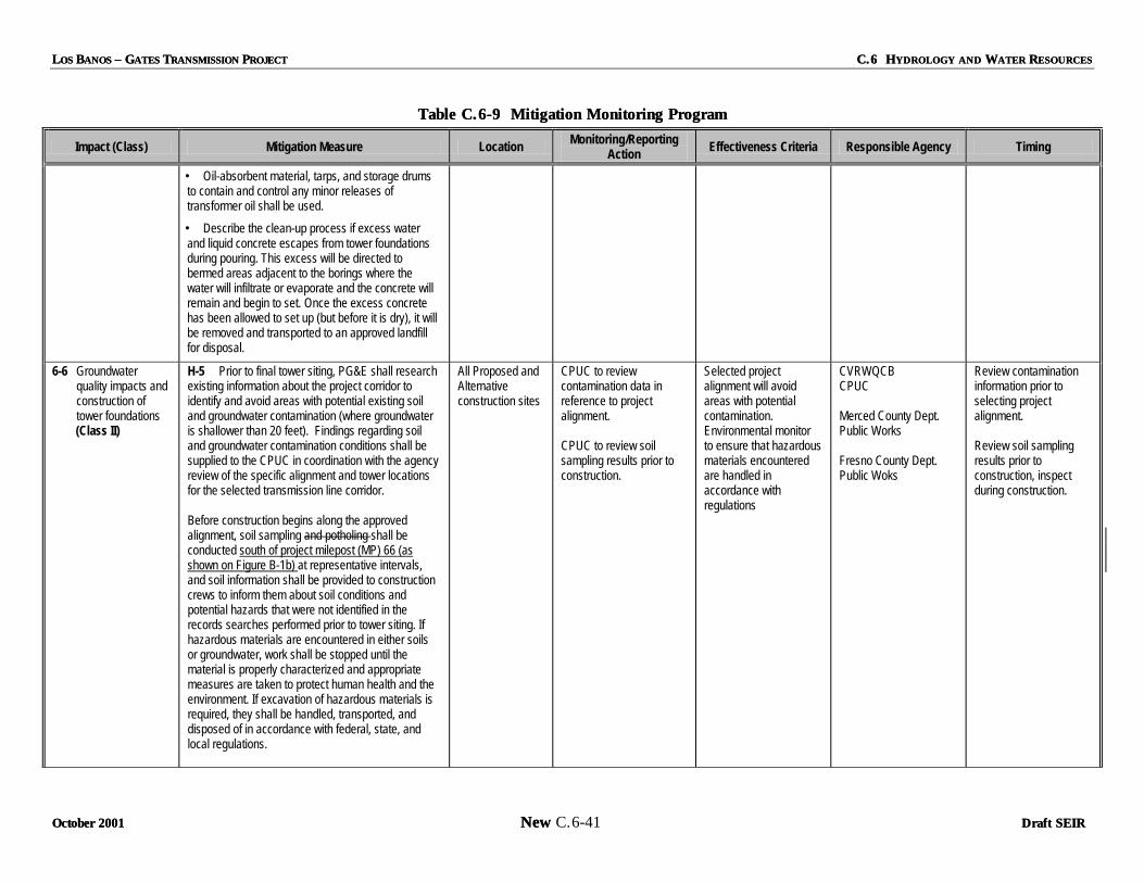
LLOS OS BBANOS ANOS –– G GATES ATES TTRANSMISSION RANSMISSION PPROJECT ROJECT C.6 HC.6 HYDROLOGY AND YDROLOGY AND WWATER ATER RRESOURCESESOURCES
October 2001October 2001 New New C.6-41 Draft SEIRDraft SEIR
Table C.6Table C.6--9 Mitigation Monitoring Program9 Mitigation Monitoring Program
Impact (Class) Mitigation Measure Location Monitoring/Reporting Action Effectiveness Criteria Responsible Agency Timing
• Oil-absorbent material, tarps, and storage drums to contain and control any minor releases of transformer oil shall be used.
• Describe the clean-up process if excess water and liquid concrete escapes from tower foundations during pouring. This excess will be directed to bermed areas adjacent to the borings where the water will infiltrate or evaporate and the concrete will remain and begin to set. Once the excess concrete has been allowed to set up (but before it is dry), it will be removed and transported to an approved landfill for disposal.
6-6 Groundwater quality impacts and construction of tower foundations
(Class II)
H-5 Prior to final tower siting, PG&E shall research existing information about the project corridor to identify and avoid areas with potential existing soil and groundwater contamination (where groundwater is shallower than 20 feet). Findings regarding soil and groundwater contamination conditions shall be supplied to the CPUC in coordination with the agency review of the specific alignment and tower locations for the selected transmission line corridor. Before construction begins along the approved alignment, soil sampling and potholing shall be conducted south of project milepost (MP) 66 (as shown on Figure B-1b) at representative intervals, and soil information shall be provided to construction crews to inform them about soil conditions and potential hazards that were not identified in the records searches performed prior to tower siting. If hazardous materials are encountered in either soils or groundwater, work shall be stopped until the material is properly characterized and appropriate measures are taken to protect human health and the environment. If excavation of hazardous materials is required, they shall be handled, transported, and disposed of in accordance with federal, state, and local regulations.
All Proposed and Alternative construction sites
CPUC to review contamination data in reference to project alignment. CPUC to review soil sampling results prior to construction.
Selected project alignment will avoid areas with potential contamination. Environmental monitor to ensure that hazardous materials encountered are handled in accordance with regulations
CVRWQCB CPUC Merced County Dept. Public Works Fresno County Dept. Public Woks
Review contamination information prior to selecting project alignment. Review soil sampling results prior to construction, inspect during construction.

C.6 HC.6 HYDROLOGY AND YDROLOGY AND WWATER ATER RRESOURCESESOURCES LLOS OS BBANOS ANOS –– G GATES ATES TTRANSMISSION RANSMISSION PPROJECTROJECT
Draft SEIRDraft SEIR New New C.6-42 October 20October 200101
Table C.6Table C.6--9 Mitigation Monitoring Program9 Mitigation Monitoring Program
Impact (Class) Mitigation Measure Location Monitoring/Reporting Action Effectiveness Criteria Responsible Agency Timing
6-8 Los Banos and Gates Substation upgrades and construction-related impacts to surface water and groundwater quality (Class II)
H-1, H-3, and H-4 (see above) Los Banos and Gates Substations
CPUC to review construction plans; monitor construction.
Compliance with Best Management Practices, SWPPP, and ECP. Permits issued; inspections during construction show no significant impacts. Construction-related sediment is prevented from reaching drainage network.
CVRWQCB CPUC Merced County Dept. Public Works Fresno County Dept. Public Woks USACOE
Review plans and permits prior to construction, inspect during construction.
6-10 Risk of transmission tower damage through flooding or erosion (Class II)
H-6 Transmission towers shall not be sited within a distance of 200 feet from the edge of stream channels a designated 100-year floodplain. Prior to final alignment of transmission towers, the Applicant shall evaluate the position of all towers in light of the most recent (July 2001 or later) floodplain delineations in the project area. To demonstrate compliance, PG&E shall provide the CPUC with a map of towers locations relative to stream courses within 100 feet of identified floodplains 30 days prior to the start of construction.
Along the Proposed or Alternative Project Corridors.
CPUC to review tower alignment plans in terms of recent floodplain delineationsin relation to stream locations.
Selected project alignment will avoid tower locations on 100-year floodplains.within 200 feet of edge of stream channels
Merced County Dept. Public Works Fresno County Dept. Public Woks CPUC USACOE CVRWQCB CPUC Merced County Dept. Public Works Fresno County Dept. Public Woks
Review plans and permits prior to construction.
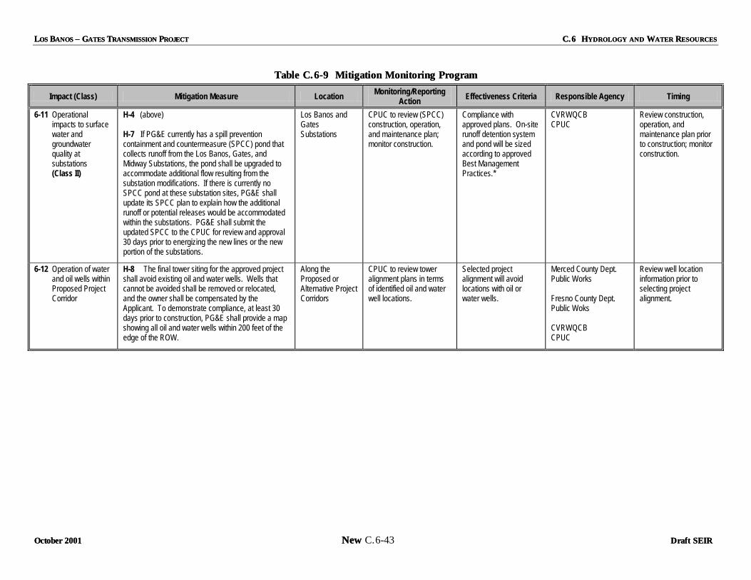
LLOS OS BBANOS ANOS –– G GATES ATES TTRANSMISSION RANSMISSION PPROJECT ROJECT C.6 HC.6 HYDROLOGY AND YDROLOGY AND WWATER ATER RRESOURCESESOURCES
October 2001October 2001 New New C.6-43 Draft SEIRDraft SEIR
Table C.6Table C.6--9 Mitigation Monitoring Program9 Mitigation Monitoring Program
Impact (Class) Mitigation Measure Location Monitoring/Reporting Action Effectiveness Criteria Responsible Agency Timing
6-11 Operational impacts to surface water and groundwater quality at substations (Class II)
H-4 (above) H-7 If PG&E currently has a spill prevention containment and countermeasure (SPCC) pond that collects runoff from the Los Banos, Gates, and Midway Substations, the pond shall be upgraded to accommodate additional flow resulting from the substation modifications. If there is currently no SPCC pond at these substation sites, PG&E shall update its SPCC plan to explain how the additional runoff or potential releases would be accommodated within the substations. PG&E shall submit the updated SPCC to the CPUC for review and approval 30 days prior to energizing the new lines or the new portion of the substations.
Los Banos and Gates Substations
CPUC to review (SPCC) construction, operation, and maintenance plan; monitor construction.
Compliance with approved plans. On-site runoff detention system and pond will be sized according to approved Best Management Practices.*
CVRWQCB CPUC
Review construction, operation, and maintenance plan prior to construction; monitor construction.
6-12 Operation of water and oil wells within Proposed Project Corridor
H-8 The final tower siting for the approved project shall avoid existing oil and water wells. Wells that cannot be avoided shall be removed or relocated, and the owner shall be compensated by the Applicant. To demonstrate compliance, at least 30 days prior to construction, PG&E shall provide a map showing all oil and water wells within 200 feet of the edge of the ROW.
Along the Proposed or Alternative Project Corridors
CPUC to review tower alignment plans in terms of identified oil and water well locations.
Selected project alignment will avoid locations with oil or water wells.
Merced County Dept. Public Works Fresno County Dept. Public Woks CVRWQCB CPUC
Review well location information prior to selecting project alignment.

C.6 HC.6 HYDROLOGY AND YDROLOGY AND WWATER ATER RRESOURCESESOURCES LLOS OS BBANOS ANOS –– G GATES ATES TTRANSMISSION RANSMISSION PPROJECTROJECT
Draft SEIRDraft SEIR New New C.6-44 October 2001October 2001
C.6.7C.6.7 RREFERENCESEFERENCES
California Biodiversity Council and UC Davis Information Center for the Environment, Natural Resources Project Inventory: Watershed Project Inventory Website. 2001. Http://endeavor.des. ucdavis.edu/wpi/ lists watershed projects and studies by County with contact information.
California Department of Fish and Game, Wildlife and Habitat Data Analysis Branch (DFG). 1997. Website. Http://maphost.dfg.ca.gov/wetlands/default.htm, detailed delineation of vernal pools and other wetlands areas.
California Resources Agency (CRA). 1995. San Joaquin River Management Plan, prepared by an advisory council established by Assembly Bill 3603. February.
CPUC (California Public Utilities Commission). 2000. Tri-Valley 2002 Capacity Increase Project, Draft Environmental Report (Volume I). December.
_____. 1997. Website. Http://maphost.dfg.ca.gov/wetlands/vp_asses_rept/fig11.htm. Broad delineation of vernal pool regions for the Central Coast Vernal Pool Region.
Central Valley Regional Water Quality Control Board (CVRWQCB). 1998. The Water Quality Control Plan (Basin Plan) for the California Regional Water Quality Control Board, Central Valley Region, 4th edition, The Sacramento River Basin and The San Joaquin River Basin. Website. Http://www.swrcb.ca.gov/rwqcb5/files.html#anchor616381.
DWR (California Department of Water Resources). 1998. California Water Plan Update (Bulletin 160-98), p.4-29, Figure 4-9: Areas of Shallow Groundwater in the San Joaquin Valley.
_____. 1998b. California Water Plan (Bulletin 160-98), Chapter 8. Options for Meeting Future Water Needs in Interior Regions of California, San Joaquin River Hydrologic Region. Available at http://rubicon.water.ca.gov/b16098/v2txt/ch8sj.html
_____. Division of Planning and Assistance. 2001. Website. Http://well.water.ca.gov/. Current and historic groundwater monitoring well data.
_____. Division of Planning and Assistance, San Joaquin District. 1997. Website. Http://wwwdpla. water.ca.gov/sjd/waterquality/drainage/. Groundwater level (1991, 1997) and electric conductivity (1995) contour maps for the Central Valley.
_____. San Joaquin District. 1998. Boundaries of Public Water Agencies, San Joaquin Valley (map).
_____. Groundwater well monitoring websites. Http://wwwdpla.water.ca.gov/sjd/waterquality/drainage/ and Http://well.water.ca.gov/.
_____. San Joaquin Valley, Drainage Monitoring Program. 1997. District Report (March 2000).
EPA (U.S. Environmental Protection Agency). 2001. Website. Http://www.epa.gov/surf3/hucs/ 18040001/. General watershed information for the Middle San Joaquin-Lower Chowchilla watershed.
Federal Emergency Management Agency (FEMA). Merced County Flood Insurance Rate Maps (1995) and Fresno County (2001, not yet reviewed).
LLOS OS BBANOS ANOS –– G GATES ATES TTRANSMISSION RANSMISSION PPROJECTROJECT C.6 HC.6 HYDROLOGY AND YDROLOGY AND WWATER ATER RRESOURCESESOURCES
OctobeOctober 2001r 2001 New New C.6-45 Draft SEIRDraft SEIR
Mayer, Carlynn. 2001. Water Management Section, California Department of Water Resources, Fresno, Ca.
PG&E (Pacific Gas & Electric Company). 1986. Los Banos-Gates 500 kV Transmission Project Environmental Report and Technical Appendices. September.
Planert, Michael and John S. Williams. USGS. 1995. Ground Water Atlas of the United States - Segment 1 California Nevada By Central Valley Aquifer System, Ground Water Quality. Website. Http://ca.water.usgs.gov/gwatlas/valley/quality.html.
TANC/WAPA (Transmission Agency of Northern California and Western Area Power Administration). 1986. Draft Environmental Impact Statement/Environmental Impact Report for the California-Oregon Transmission Project and the Los Banos-Gates Transmission Project. November.
_____. 1988. Final Environmental Impact Statement/Environmental Impact Report for the California-Oregon Transmission Project and the Los Banos-Gates Transmission Project. January.
United States Army Corps of Engineers (USACE), California Department of Water Resources (DWR), and U.S. Bureau of Reclamation (BOR). 1999. San Joaquin River Basin, Arroyo Pasajero (Fresno County), CA, Feasibility Investigation, Draft Feasibility Report. March.
United States Bureau of Reclamation (BOR). 2001. Website. Http://dataweb.usbr.gov/. Information on BOR Central Valley Project reservoirs and facilities.
United States Department of the Interior and the California Resources Agency. 1990. A Management Plan for Agricultural Subsurface Drainage and Related Problems on the Westside San Joaquin Valley (Rainbow Report). Website. Http://wwwdpla.water.ca.gov/agriculture/drainage/implementation/ hq/rainbowreport.pdf. September.
Westlands Water District. 2001. Website. Http://www.westlandswater.org/. Shallow and deep groundwater elevation and depth contour maps (biennial, 1993-2001).