cadastral systems l. perovych lviv polytechnic national university ukraine
TRANSCRIPT

CADASTRAL SYSTEMS
L. Perovych Lviv Polytechnic National University
Ukraine

Cadastral Systems
Williamson, Enemark, Wallace, Rajabifard, 2010
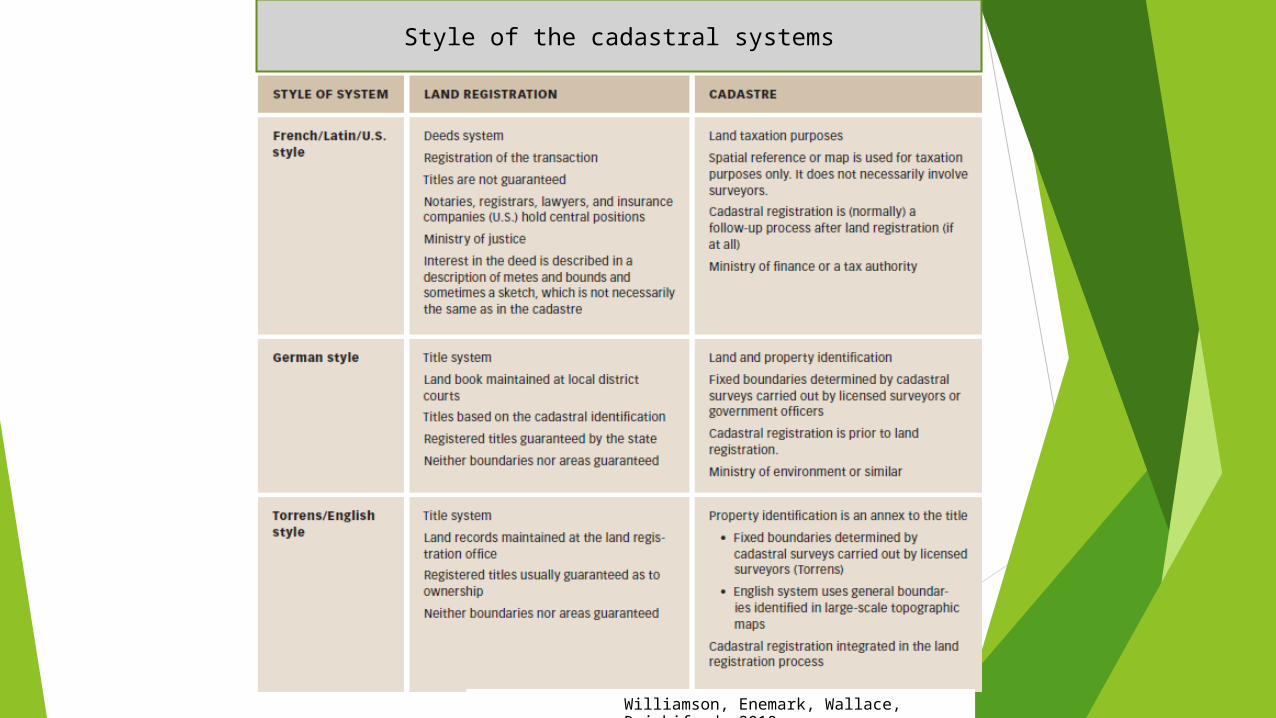
Style of the cadastral systems

Land Registration Systems around the World
Deeds System (French/Latin/USA style): A register of owners; the transaction is recorded – not the title.Title System (German, Torrens/English style): A register of properties; the title is recorded and guarantied.

German cadastral system

The Federal Republic ofGermany consists of
16 states („Laender“)
Capital: Berlin
Area: 357.023 sqkm
Inhabitants: 82,5 mio.
Some Facts about Germany

Ministry of Interior
HHMinistry of EconomySH
MVMinistry
Ministry
Ministry
of
of
of
Planning
Environment
Agriculture
HBNI BE
LSA BBNW
SNTHHE Minstry of Finance
State LevelRP
Municipal LevelSL BYBW
Without hatching: 1 organisation
Ministries of Reference
••
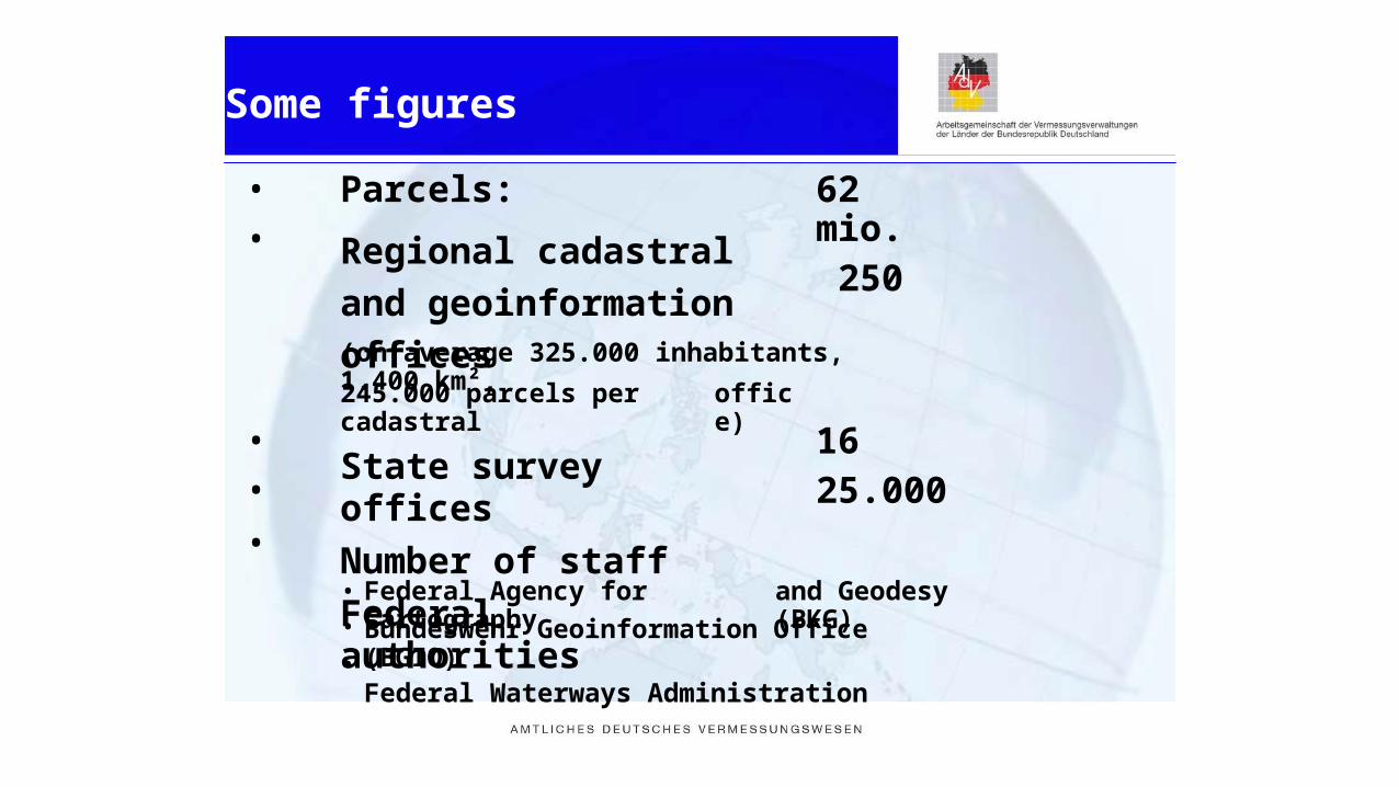
Parcels:
Regional cadastral and
geoinformation offices
62 mio. 250
(on average 325.000 inhabitants, 1.400 km²,
245.000 parcels per cadastral
State survey offices
Number of staff
Federal authorities
office)
••
•
1625.000
••
•
Federal Agency for Cartography and Geodesy (BKG)
Bundeswehr Geoinformation Office (BGIO)Federal Waterways Administration
Some figures

••
Licensed surveyors in 15 states
Job of a licensed surveyor is regulated by state laws
Job is understood as a regulated profession (Art. 45 EG Treaty of Rome) and therefore no PPP
•
••
•
Number of licensed surveyors: 1500
Number of staff : 15.000
1300 licensed surveyors are member ofBDVI (voluntary association, no chamber)
Private sector (licensed)
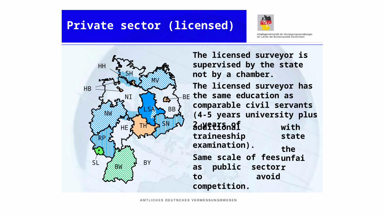
The licensed surveyor issupervised by the state not by a chamber.
The licensed surveyor has the same education as comparable civil servants (4-5 years university plus 2 years of
HHSH
MVHB
NI BE
LSA BBNW
SNTH additional traineeshipexamination).
Same scale of fees as public sector to avoid competition.
with stateHE
RP
theunfair
SL BYBW
Private sector (licensed)
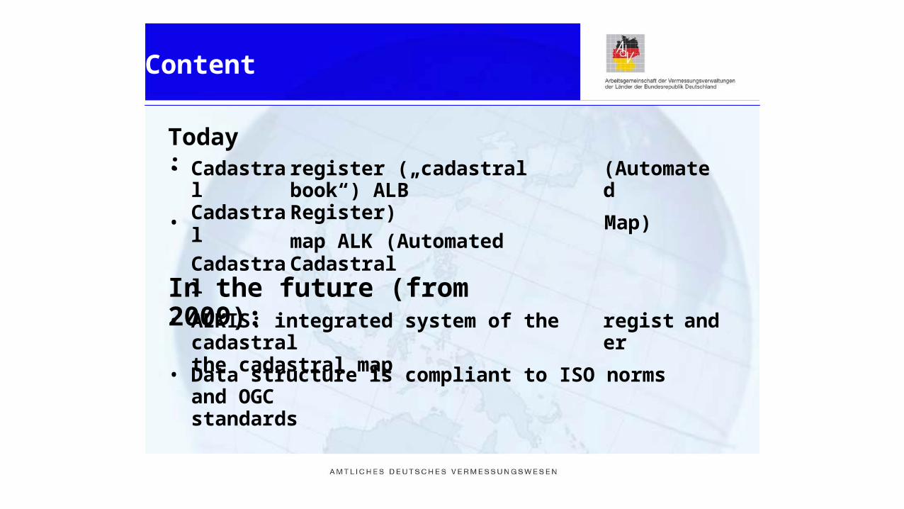
Today:• Cadastral
Cadastral
Cadastral
register („cadastral book“) ALBRegister)
map ALK (Automated Cadastral
(Automated
• Map)
In the future (from 2009):• ALKIS: integrated system of the cadastral
the cadastral mapregister and
• Data structure is compliant to ISO norms and OGCstandards
Content

French cadastral system

Its main missions are :
- fiscal (evaluation of real estate, determination of the bases for property taxes,
identification of the taxable owners),
- legal and property related (identification and physical description of
properties),
- technical (establishment of the cadastral plan and keeping it up-to-date,
topographical pictures essential for the identification and physical description
of the property if question).
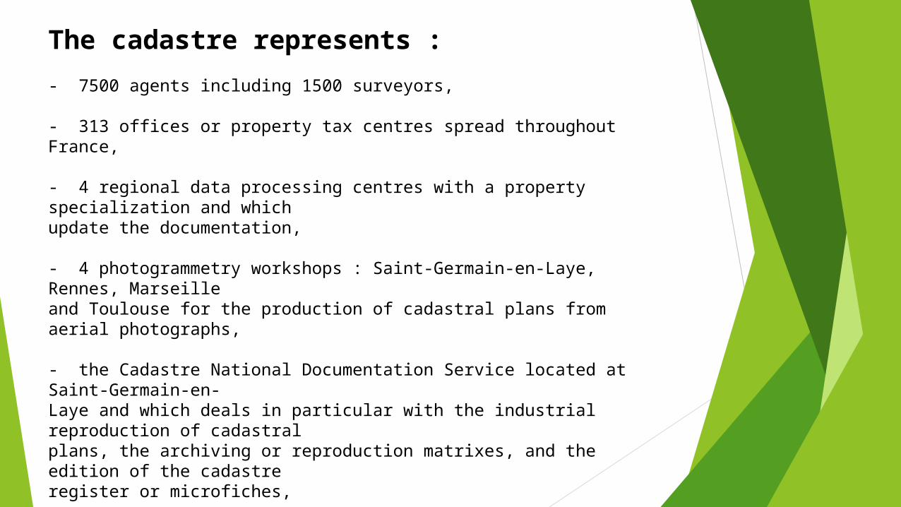
The cadastre represents : - 7500 agents including 1500 surveyors, - 313 offices or property tax centres spread throughout France, - 4 regional data processing centres with a property specialization and which update the documentation, - 4 photogrammetry workshops : Saint-Germain-en-Laye, Rennes, Marseille and Toulouse for the production of cadastral plans from aerial photographs, - the Cadastre National Documentation Service located at Saint-Germain-en-Laye and which deals in particular with the industrial reproduction of cadastral plans, the archiving or reproduction matrixes, and the edition of the cadastre register or microfiches, - the Ecole Nationale du Cadastre in Toulouse providing the basic professional training of agents.
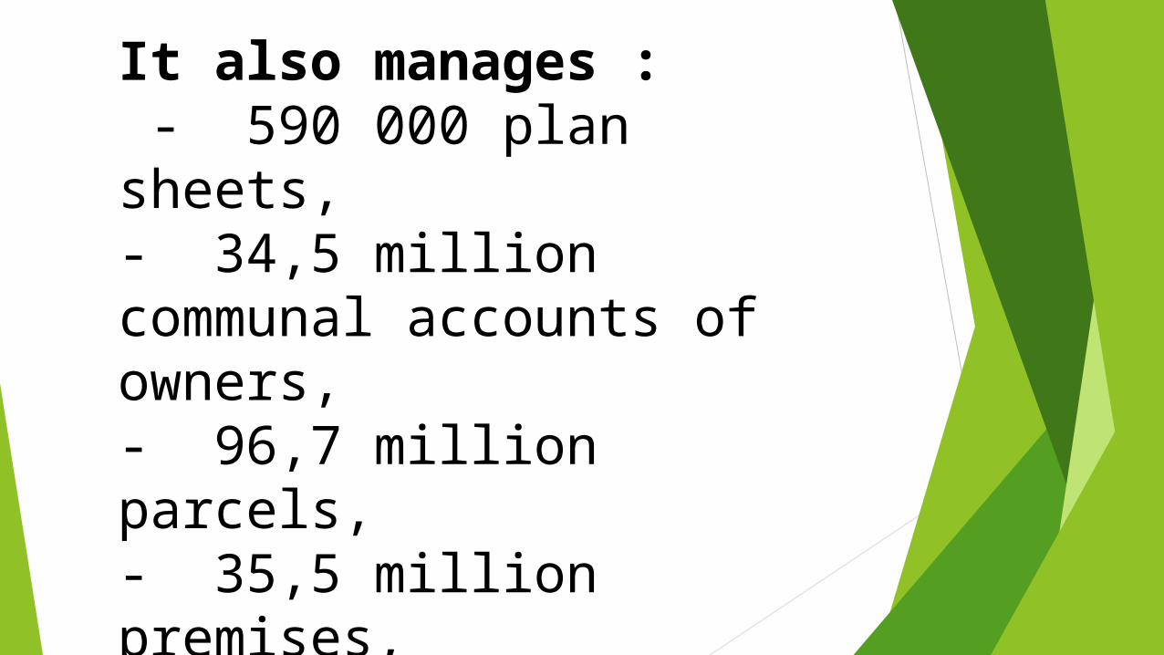
It also manages : - 590 000 plan sheets, - 34,5 million communal accounts of owners, - 96,7 million parcels, - 35,5 million premises, - 5,7 million names of localities, - 680 000 names of roads

Poland cadastral system

Main characteristics of thecadastral systemLand and Building Register:
in Poland
responsibility
of Surveyor General
of Poland
(Ministry
of Public
¾Administration and Internal Affairs)covers continuously the whole territory of Poland cadastral parcels)consists of two parts – descriptive and graphical¾ Descriptive is numerical in 100%¾ Graphical part is victories in 75%
(312 000km2, 33mln
¾
¾
maintenance
is a governmental
task but
delegated
to the
¾bodieslinke
d th
eother
register
concerning
property
data
by the
¾e procedures stipulated by the law supported by
technicalsolutions.
: and Mortgage Register -
Ministry of JusticeTax Register - Ministry of
Finance

AUTHORITIES FORLAN
DANDBUILDING
SREGISTER
control starostas’ (district chief officials) actions within the scope of these tasks
475
Chiefs poviat officials (starostas)or Presidents of the city governed on
district laws
run the real estate registerperform their tasks with the assistance of the poviat
surveyors
Province heads (voivodes)16
perform their tasks with the assistance of Regional Inspectors for Geodetic and
Cartographic Supervision
Surveyor General of Polandcentral governmental administration unit
supervises the State policy within the scope of geodesy and cartography performs his tasks with the assistance of the Head Office of Geodesy and Cartography

INTEGRATING ELECTRONIC
PLATFORM (IPE)Integrating
Electronic
Platform
(IPE) System enables
exchange of
databetween land and buildings register and land and mortgage registry
and taxregister.Also it allows access to data from land and buildings registers for the needs of theother IT systems run by public administration bodies, verification of data
in landCensusand buildings registers with data held in PESEL (Universal
PopulationRegister)
andREGON
(National
Official
Register
of Economic
Subjects).
Data integration
within IPE system
European requirements for
cadastral surveyor

Approximate number of licensed cadastral surveyors (individuals)
per country

Approximate number of licensed companies that execute cadastral
surveying

Types of licensed cadastral surveyors

Licensing (authorisation) requirements

Compulsory period of professional practice required before applying for a cadastral
licence surveyor

Organisations provide training and education for cadastral
surveyors

Minimum duration of education after secondary school before becoming a licensed cadastral
surveyor

Disciplines for education after the secondary school

Main tasks and duties of cadastral surveyors

Ukraine cadastral system

Based in Ukraine passed one of the important stages of land reform - deregulation and Based in Ukraine passed one of the important stages of land reform - deregulation and privatization of land. Launched a market turnover of land, although it is not complete because privatization of land. Launched a market turnover of land, although it is not complete because
there is a moratorium on the sale of agricultural land.there is a moratorium on the sale of agricultural land.The state has changed significantly in the structure of land fund of the country and in the forms The state has changed significantly in the structure of land fund of the country and in the forms
of their ownershipof their ownership
Area 603,6 thousands sq. km;Area 603,6 thousands sq. km;Population: 45,8 million people;Population: 45,8 million people;71% agricultural land;71% agricultural land;17,6% forest land;17,6% forest land;4,6% - built-up land;4,6% - built-up land;4,0% - water land; 4,0% - water land; 2,8% - other.2,8% - other.
17,6%
4,6%
71,0%
2,8%
4,0%
The structure of land in Ukraine ( 01.01.2011)
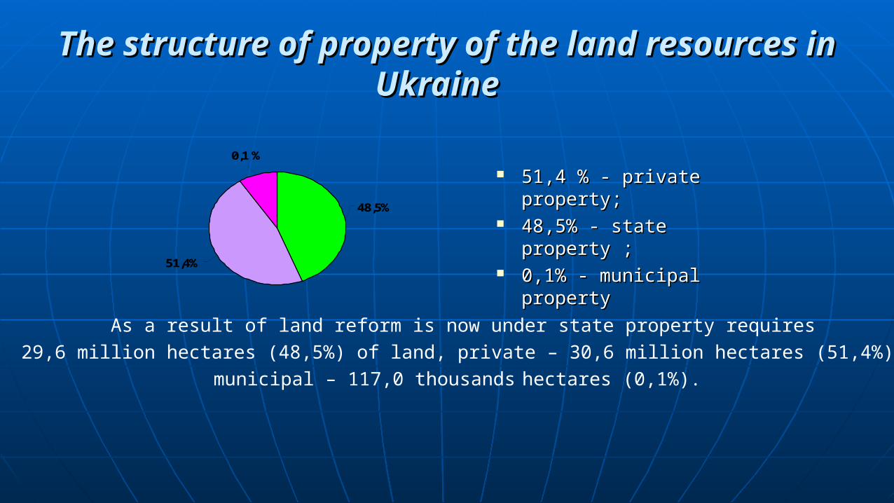
The structure of property of the land resources in The structure of property of the land resources in UkraineUkraine
51,4 % - private property;51,4 % - private property; 48,5% - state property ;48,5% - state property ; 0,1% - municipal property0,1% - municipal property
48,5%
51,4%
0,1 %
As a result of land reform is now under state property requires
29,6 million hectares (48,5%) of land, private – 30,6 million hectares (51,4%),
municipal – 117,0 thousands hectares (0,1%).

Ministry regional development
State department geodesy and cadastre
Regional department of land resources
(27 departments)
State Center of Land Cadastre(SCC)
District Department of Land Resources
(665 departments)
Regional departments (SCC)(27 departments)
District Department (SCC)(665 departments)


Types of lincesed of the land market firm

Organisations provide training and education

THANK YOU