caithness petroleum limited helmsdale, forse, braemore and
TRANSCRIPT

Gardline Project Ref. 8886 – 9 DECC Ref. 2217 Fieldwork Dates 9th – 24th September 2011 Report Status Final Issue Date 1st November 2011
Gardline Environmental Ltd
Endeavour House, Admiralty Road, Great Yarmouth, Norfolk NR30 3NG. England Telephone +44 (0) 1493 845600 Fax +44 (0) 1493 852106 http://www.gardline.com
CAITHNESS PETROLEUM LIMITED
HELMSDALE, FORSE, BRAEMORE AND BURRIGILL
2D AND SITE SURVEYS
UKCS BLOCKS 11/23, 11/24, 11/25, 12/21, 11/27, 11/28, 11/30, 12/26, 17/2, 17/3
SEPTEMBER 2011
MARINE MAMMAL OBSERVATIONS AND PASSIVE ACOUSTIC MONITORING REPORT
Caithness Petroleum Limited Gardline Project Ref. 8886 - 9 UKCS Blocks 11, 12, 17 Marine Mammal Observations and PAMS Report
i
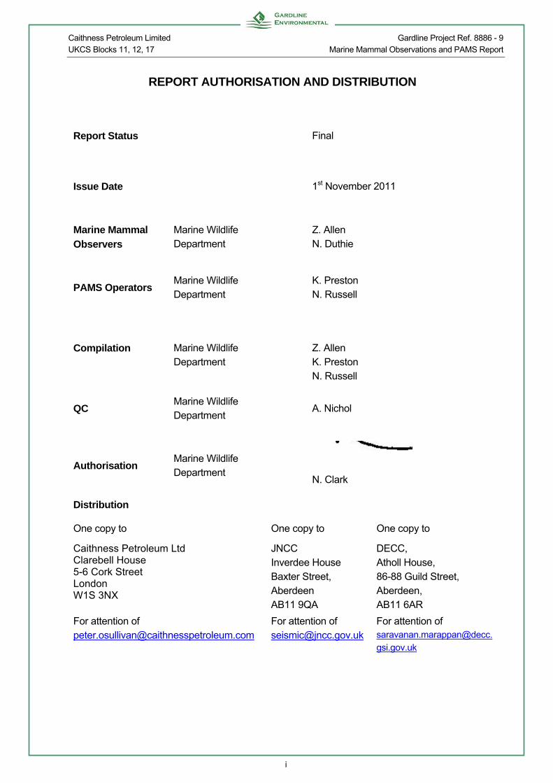
REPORT AUTHORISATION AND DISTRIBUTION
Report Status Final
Issue Date 1st November 2011
Marine Mammal
Observers
Marine Wildlife Department
Z. Allen N. Duthie
PAMS Operators Marine Wildlife Department
K. Preston N. Russell
Compilation Marine Wildlife Department
Z. Allen K. Preston N. Russell
QC Marine Wildlife Department
A. Nichol
Authorisation Marine Wildlife Department
N. Clark
Distribution
One copy to One copy to One copy to
Caithness Petroleum Ltd Clarebell House 5-6 Cork Street London W1S 3NX
JNCC Inverdee House Baxter Street, Aberdeen AB11 9QA
DECC, Atholl House, 86-88 Guild Street, Aberdeen, AB11 6AR
For attention of [email protected]
For attention of [email protected]
For attention of [email protected]

Caithness Petroleum Limited Gardline Project Ref. 8886 - 9 UKCS Blocks 11, 12, 17 Marine Mammal Observations and PAMS Report
ii
SERVICE WARRANTY
USE OF THIS REPORT This report, with its associated works and services, has been designed solely to meet the requirements of the contract agreed with you, our client. If used in other circumstances, some or all of the results may not be valid and we can accept no liability for such use. Such circumstances include different or changed objectives, use by third parties, or changes to, for example, site conditions or legislation occurring after completion of the work. In case of doubt, please consult Gardline Environmental Ltd.
Gardline Environmental Ltd Endeavour House, Admiralty Road, Great Yarmouth, Norfolk NR30 3NG. England
Telephone +44 (0) 1493 845600 Fax +44 (0) 1493 852106 http://www.gardline.com

Caithness Petroleum Limited Gardline Project Ref. 8886 - 9 UKCS Blocks 11, 12, 17 Marine Mammal Observations and PAMS Report
iii
EXECUTIVE SUMMARY
Watches for marine animals occurred during three 2D seismic surveys and one site survey on the Sea Surveyor from 9th September to 24th September. The 2D surveys were performed in UKCS Blocks 11/27, 11/28, 17/02 and 17/03 (Helmsdale site), Blocks 11/23 and 11/24 (Forse site) and Blocks 11/25, 11/30, 12/21 and 12/26 (Braemore site). The site survey was carried out in UKCS Blocks 11/24 and 11/25 (Burrigill site).
Weather conditions recorded during the survey were highly variable with wind force ranging from Beaufort force 1 to force 8, and sea state ranging from glassy to rough. Visibility was predominantly good and swell predominantly low.
The 2D seismic surveys utilised airguns on nine days of the survey, to run a total of 52 2D seismic survey lines (including reruns) and two gun tests.
There were a total of 53 soft starts conducted during the 2D surveys. Of these, 33 were during daylight hours and low light hours if occurred during dusk and dawn and were covered by full pre-shoot watches.
The high resolution seismic surveys utilised airguns on two days of the survey, to run a total of 20 high resolution seismic survey lines (including reruns) and one gun test.
There were a total of 21 soft starts conducted during the survey. Of these, nine were during daylight hours and low light hours and were covered by full pre-shoot watches.
Monitoring for marine animals, both visually and acoustically, occurred over 12 days, totalling 111 hours and 16 minutes of visual monitoring effort and 181 hours and 59 minutes of PAM effort.
During the survey there were 22 sightings and one acoustic detection of marine mammals.
During the survey there were no incidences where the 2D seismic or high resolution seismic acquisition was delayed due to the close proximity of marine mammals, turtles or sharks.

Caithness Petroleum Limited Gardline Project Ref. 8886 - 9 UKCS Blocks 11, 12, 17 Marine Mammal Observations and PAMS Report
iv
LOCATION MAP

Caithness Petroleum Limited Gardline Project Ref. 8886 - 9 UKCS Blocks 11, 12, 17 Marine Mammal Observations and PAMS Report
v
TABLE OF CONTENTS
REPORT AUTHORISATION AND DISTRIBUTION i
SERVICE WARRANTY ii
EXECUTIVE SUMMARY iii
LOCATION MAP iv
TABLE OF CONTENTS v
LIST OF FIGURES vii
1. INTRODUCTION 1
1.1 Background 1 1.2 Objective 3
2. THE MARINE ENVIRONMENT 4
2.1 Physical Environment and Oceanographic Features 4 2.2 Marine Communities 4
3. METHODOLOGY 6
3.1 Study Area 6 3.2 Survey Vessel 6 3.3 Survey Parameters 7
3.3.1 High Resolution Seismic Survey 7 3.4 Operators Procedures 13
3.4.1 Conditions of the PoN14 14 3.5 Observation Methods 15 3.6 Acoustic Monitoring 15
3.6.1 Hydrophone streamer 16 3.6.2 Monitoring system 16
3.7 Communication Procedures 17
4. RESULTS 18
4.1 Survey Coverage 18 4.2 Weather Conditions 19 4.3 Communications 23 4.4 Compliance with JNCC Guidelines 23
4.4.1 Variations to the PoN14 23 4.5 Marine Animal Sightings 23
4.5.1 Northern minke whale (Balaenoptera acutorostrata) 23 4.5.2 Bottlenose Dolphin (Tursiops truncatus) 24 4.5.3 Risso’s Dolphins (Grampus griseus) 25 4.5.4 Harbour Porpoise (Phocoena phocoena) 26 4.5.5 Common Seal (Phoca vitulina) 27 4.5.6 Grey Seal (Halichoerus grypus) 27
4.6 Acoustic Detections 29
5. DISCUSSION 30
5.1 Marine Animal Detection 30 5.2 Marine Animal Observation 31

Caithness Petroleum Limited Gardline Project Ref. 8886 - 9 UKCS Blocks 11, 12, 17 Marine Mammal Observations and PAMS Report
vi
6. REFERENCES 32
7. APPENDICES 38
Caithness Petroleum Limited Gardline Project Ref. 8886 - 9 UKCS Blocks 11, 12, 17 Marine Mammal Observations and PAMS Report
vii
LIST OF FIGURES
Figure 1.1 Frequencies used by marine mammals and main frequency range of seismic activity 1
Figure 3.1 Completed line plan for Helmsdale 2D seismic survey 10 Figure 3.2 Completed line plan for Forse 2D seismic survey 11 Figure 3.3 Completed line plan for the Braemore 2D seismic survey 12 Figure 3.4 Completed HRS line plan for the Burrigill site survey 13 Figure 3.5 Systematic diagram of the passive acoustic monitoring system. 16 Figure 4.1 Wind force recorded during dedicated watches on the Helmsdale 2D survey 20 Figure 4.2 Sea state recorded during dedicated watches on the Forse 2D survey 21 Figure 4.3 Visibility recorded during dedicated watches on the Forse 2D survey 21 Figure 4.4 Sea state recorded during dedicated watches on the Braemore 2D survey 22 Figure 4.5 Wind force recorded during dedicated watches on the Burrigill HRS site survey
22 Figure 4.6 Bottlenose dolphins seen on 14th September 2011 in transit to the Forse site 25 Figure 4.7 Risso’s dolphins seen on 19th September 2011 at the Forse site 26 Figure 4.8 Harbour porpoise seen on 15th September 2011 at the Forse site. 27 Figure 4.9 Grey seal seen on 15th September 2011 at Forse site. 28 Figure 4.10 Detection of Risso’s dolphins’ echolocation clicks on 19th September 2011. 29
LIST OF TABLES Table 3.1 Seismic survey location 6 Table 3.2 Vessel particulars 7 Table 3.3 2D survey equipment, Helmsdale site 8 Table 3.4 2D survey equipment, Forse and Braemore sites 8 Table 3.5 Site survey high resolution survey equipment, Burrigill site 9 Table 4.1 Summary of 2D data acquisition for the Helmsdale, Forse and Braemore surveys
19 Table 4.2 Summary of HRS data acquisition for the Burrigill survey 19

Caithness Petroleum Limited Gardline Project Ref. 8886 - 9 UKCS Blocks 11, 12, 17 Marine Mammal Observations and PAMS Report
- 1 -
1. INTRODUCTION
1.1 Background
Sound is conducted through water approximately 4.5 times faster than through air thus it is the most important sense for many marine organisms. This is especially true for marine mammals which use sound to communicate, navigate, forage and for predator avoidance. The frequency range used by marine mammals varies between 10 Hz - >200 kHz, with the large baleen whales using the lower frequencies while smaller toothed whales use higher frequencies (Gotz et al, 2009) (Figure 1.1).
Figure 1.1 Frequencies used by marine mammals and main frequency range of seismic
activity Seismic surveys are performed to establish and investigate geological structures associated with hydrocarbon deposits in the seabed. Airgun arrays are the most common energy sources used in marine seismic surveys. Air, under high pressure, is released into the water from airguns towed behind the vessel and is reflected by rock and other sedimentary layers and subsequently detected by hydrophones that are located in towed cables. Seismic airguns generate low frequency sound pulses below 250 Hz (DeRuiter, 2006) with the strongest energy between 30-50 Hz. Incidental noise up to 100 kHz is also produced from airguns (DeRuiter, 2006), this frequency range is not directed downwards as with the main frequency range but dissipates horizontally. The power of the airguns can reach a maximum power of approximately 260 dB re. 1 μPa @1m (Gotz et al, 2009). It has been shown that in suitable oceanic environments seismic activity can be detected above background noise at 3000 km (Nieukirk et al, 2004). Sound can impact marine mammals in varying degrees of severity from behavioural response to physiological damage, generally limited to the auditory system (Gotz et al, 2009). The most commonly observed effects are behavioural changes. It was shown that acoustic disturbance within a lagoon caused a grey whale (Eschrichtius robustus) population to avoid the area until several years after the disturbance had ceased (National Research Council, 2005). Several species of baleen whale have displayed avoidance behaviour to seismic surveys, although in some species, this does seem to be sex specific. For instance male humpback whales (Megaptera novaeangliae) have reportedly been either attracted or tolerant of seismic activity, while females display avoidance behaviour (Gotz et al, 2009). One study by Clark and Gagnon (2006) showed that a group of fin

Caithness Petroleum Limited Gardline Project Ref. 8886 - 9 UKCS Blocks 11, 12, 17 Marine Mammal Observations and PAMS Report
- 2 -
whales (Balaenoptera physalus) ceased all vocalisation until after completion of the survey. It is hard to predict what such behavioural responses to seismic activity will do to a population but these may include long-term behavioural responses, migratory disruption, shifts in feeding distributions and residential displacement (Evans & Nice, 1996; Morton & Symonds, 2002; Gordon et al, 2003), however varying views within the scientific community make such predictions cautionary. There have been some links between seismic activity and mass strandings but none of these have been confirmed and there is no conclusive evidence that seismic activity causes these strandings (Gotz et al, 2009). There has been some research into the impact of seismic activity on the auditory systems of marine mammals, most of which has been focused around toothed whales. Research points towards the fact that seismic activity can cause Temporary Threshold Shifts (TTS) in marine mammal hearing (Finneran et al, 2002; Lucke et al, 2009). This occurs when high levels of noise cause the hair cells in the cochlea to begin to fatigue, making the animals hearing less effective. When these hairs eventually return to their normal shape normal hearing is resumed, however, if the hair cells are broken, or do not return to normal the damage is permanent and this is called Permanent Threshold Shift (PTS) (National Research Council, 2005). Research on toothed whales has shown that the frequencies emitted by seismic surveys could cause TTS, but the animals would have to be close to the source and there was no evidence to conclude that airguns could cause PTS (Finneran et al, 2002). There has been little research into the effects of seismic activity on basking sharks (Cetorhinus maximus); however, their surface feeding has the potential to bring them in close contact with the airguns and avoidance behaviour could lead to changes to migration routes (Bloomfield & Solandt, 2007). Long-term effects of noise disturbance could lead to weight loss and reduced reproductive success (Bloomfield & Solandt, 2007) which in turn could impact population recruitment. Some shark species have excellent hearing with sensitivity peaking around 20 Hz (Casper & Mann, 2006). These species are predatory and use sound as a means of locating prey, however it is unlikely that basking sharks have such a well developed sense of hearing due to their planktiverous diet. Marine turtles are another species potentially impacted by seismic surveys (their maximum hearing sensitivity falls in the low frequency range < 1 kHz) however it is highly unlikely that any would be found in this area. The UK Department of the Environment issued the Guidelines for minimising acoustic disturbance to small cetaceans in February 1995, as part of the government’s response to the Agreement on the Conservation of Small Cetaceans in the Baltic and North Seas (ASCOBANS). The Guidelines aimed to reduce the disturbance to cetaceans from seismic surveys in UK waters. The Guidelines were last revised August 2010. Previous revisions were in 1998, 2004 and 2009. Seismic operators were and still are subsequently required to contact the JNCC when planning surveys in UK waters to discuss methods of minimising acoustic disturbance to marine mammals. The present Guidelines (Appendix A) state that “In relation to oil and gas seismic surveys in the UKCS, it is a requirement of the consent issued under Regulation 4 of the Petroleum Activities (Conservation of Habitats) Regulations 2001 (& 2007 Amendments) by the Department for Energy Climate Change (DECC), that the JNCC Seismic Guidelines must be followed, and the elements of the Guidelines that are relevant to a particular survey are incorporated into the legally-binding condition of consent”. It should be noted that it is the responsibility of the company issued consent by the DECC that the JNCC Seismic Guidelines must be followed. It is recommended that a copy of the JNCC guidelines

Caithness Petroleum Limited Gardline Project Ref. 8886 - 9 UKCS Blocks 11, 12, 17 Marine Mammal Observations and PAMS Report
- 3 -
are available onboard all vessels undertaking seismic activities in UK waters. Where relevant, when the survey is completed a MMO report must be submitted to the JNCC. The 2010 version of the JNCC seismic guidelines reflects amendments (2007 and 2009 amendments) to the Conservation (Natural Habitats &c.) Regulations 1994 (Habitat Regulations, HR) for England and Wales and the Offshore Marine Conservation (Natural Habitats, &c.) Regulations 2007 (Offshore Marine Regulations, OMR, as amended in 2009 and 2010). Both regulations have revised the definition of deliberate disturbance of ‘European Protected Species’ (EPS), which now excludes trivial disturbance from the offence. Both regulations now also include the offence of deliberate injury. European Protected Species include cetaceans and turtles. The JNCC recommends that the soft-start procedures for marine mammals would also be appropriate for marine turtles and basking sharks. To record procedures and to detect and identify marine animals during the survey, operators are required to employ trained Marine Mammal Observers (MMOs). However, due to the incorporation of turtles and basking sharks, all watches carried out were for ‘marine animals’ and will be referred to as such throughout the report.
1.2 Objective
This report presents the findings of dedicated marine animal watches during 2D surveys on the Helmsdale (UKCS Blocks 11/27, 11/28, 17/02 and 17/03), Forse (UKCS Blocks 11/23 and 11/24) and Braemore sites (UKCS Blocks 11/25, 11/30, 12/21 and 12/26) and a site survey on the Burrigill site (UKCS Blocks 11/24 and 11/25), all of which are located in the Inner Moray Firth (see Location Map). These surveys were conducted for Caithness Petroleum Limited, on board the M.V. Sea Surveyor from 9th September to 24th September 2011.
Caithness Petroleum Limited Gardline Project Ref. 8886 - 9 UKCS Blocks 11, 12, 17 Marine Mammal Observations and PAMS Report
- 4 -
2. THE MARINE ENVIRONMENT
2.1 Physical Environment and Oceanographic Features
The ocean is a highly heterogeneous environment, with both large- and small-scale spatial patterns in oceanography (Hunt & Schneider, 1987). Fluctuations in physical and biological factors within the ocean environment will have an effect on the abundance and distribution of marine fish and zooplankton, which in turn will be reflected in specific marine populations (Thompson & Ollason, 2001). Physical processes such as circulatory patterns may have large-scale implications on the dispersion of all marine life. Equally important small-scale features, or localised episodes, will also have an overall affect. Oceanographic features vary on a temporal scale, with seasonal formation of fronts and annual fluctuations in temperature, salinity and primary production (le Fèrve, 1986; Ellett & Blindheim, 1992). The distribution of marine animals is extremely irregular and is generally related to the distribution of their food source. Marine animals feed on a variety of foodstuffs and thus their distribution is related to the movement or abundance of such food sources (e.g. Evans, 1990; Harrison et al, 1994; Begg & Reid, 1997). As the distribution and abundance of marine animals is influenced by oceanographic characteristics it is important to describe the topography and marine processes in the study area. The study area is situated in the Inner Moray Firth (see Location Map), which forms an integral part of the wider North Sea basin and Atlantic, sharing large scale environmental factors including water circulation and climate patterns (Eleftheriou et al, 2004). Two oceanographic features, identified as the Dooley current, dominate the region; a cold water current moving in from the north and a plume of warmer water emerging from the Inner Firth (Tetley et al, 2008). There are 10 major rivers which flow into the Inner Firth area substantially reducing salinity and creating an estuarine-like environment (Adams & Martin, 1986). Contained within the Inner Moray Firth are three smaller firths, the narrow mouths of which are composed of steep sided basins of over 50 m within 1 km offshore (Whaley, 2004). At this finer scale, tidal flows, bathymetry and the brackish nature of water create tidal intrusion fronts (Mendes et al, 2002). The seabed in the rest of the Inner Moray Firth slopes to a depth of 50 m approximately 15 km offshore (Holmes et al, 2004).
2.2 Marine Communities
Similar to the North Sea, Ceratium species dominate the phytoplankton, with the diatoms Hyalochaete spp. and Thaossiosira spp. also abundant within the area (Johns, 2004). In the zooplankton community, copepods particularly Calanus species have the highest abundance. Small copepods such as Acartia spp., Para-pseudocalanus spp. and juvenile Calanus are also particularly abundant. Larval stages of many benthic organisms also form an important part of this community, particularly echinoderm, decapod and coelenterate larvae (Johns, 2004). The Inner Moray Firth is considered to support a significant area of subtidal sandbank features: defined as being slightly covered by seawater at all times, these consist mainly of soft sandy sediments but larger grain sizes including boulders and cobbles, or smaller sizes including mud may also be present (Moray Firth SAC Management Group, 2009). Initial surveys show a high diversity of fauna dominated by polychaetes, bivalves Tellimya ferruginosa and Mysella bidentata

Caithness Petroleum Limited Gardline Project Ref. 8886 - 9 UKCS Blocks 11, 12, 17 Marine Mammal Observations and PAMS Report
- 5 -
and brittle star Ophiothrix fragilis (Eleftheriou et al, 2004). The Inner Moray Firth also has extensive rocky platforms that are a mixture of bedrock, boulders, cobbles and mixed sediments. The biota of these hard areas are characterised by Alcyonium digitatum and brittle stars Ophithrix fragilis and Ophiocomina nigra (Foster-Smith et al, 2009). Between these rocky outcrops, sandy muds are present in deeper waters and medium, fine, sometimes shelly sands in shallow waters. Benthic fauna is characterised by brittle stars (Amphiura sp.) and the mollusc Turritella communis. The shallowest sediments are characterised by the brittle star Ophiura ophiura, razor shells (Ensis sp.), small heart urchins Echinocardium cordatum and bivalves (Foster-Smith et al, 2009). The fish assemblage of the Inner Moray Firth is dominated by three pelagic species, sandeel (Ammodytes marinus), sprat (Sprattus sprattus) and herring (Clupea harengus). Whiting (Merlangius merlangus), haddock (Melanogrammus aeglefinus), common dab (Limanda limanda), lemon sole (Microstomus kitt) and plaice (Pleuronectes platessa) are also particularly abundant (Greenstreet et al, 1998). Three species of cetacean are known to regularly occur in the Moray Firth, the harbour porpoise (Phocoena phocoena), bottlenose dolphin (Tursiops truncatus) and minke whale (Balaenoptera acutorostrata) (Eisfield et al, 2009). The Inner Moray Firth is one of the first areas in Europe to be identified as a marine candidate Special Area of Conservation (cSAC) for bottlenose dolphins. Although bottlenose dolphins are present year round in the coastal margins (Hastie et al, 2003), they undergo distinct seasonal movements within the area, with the deep, narrow entrances to coastal inlets at the head of the Firth used most intensively particularly during the summer months (Wilson et al, 1997; Hastie et al, 2003). In contrast harbour porpoise are more widely distributed throughout the Inner Moray Firth area (Hastie et al, 2003). Minke whales regularly occur in the southern Outer Moray Firth during the summer months (Robinson et al, 2009). Individuals are also recorded in the offshore areas of the Inner Moray Firth (Bailey & Thompson, 2009). Both grey seals (Halichoerus grypus) and common seals (Phoca vitulina) are encountered in the open waters of the Inner Moray Firth. Sheltered estuaries are used as haul-out and breeding sites by common seals, while grey seal pups are found on rocky beaches and caves (Thompson et al., 1996). The Dornoch Firth is considered particularly important for common seals, supporting 2% of the UK population and has been designated a cSAC (Butler, 2004). Common seals tend to forage within 60 km of haul-out sites, while grey seals which forage in the Moray Firth travel up to 145 km from sites (Thompson et al., 1996).
Caithness Petroleum Limited Gardline Project Ref. 8886 - 9 UKCS Blocks 11, 12, 17 Marine Mammal Observations and PAMS Report
- 6 -
3. METHODOLOGY
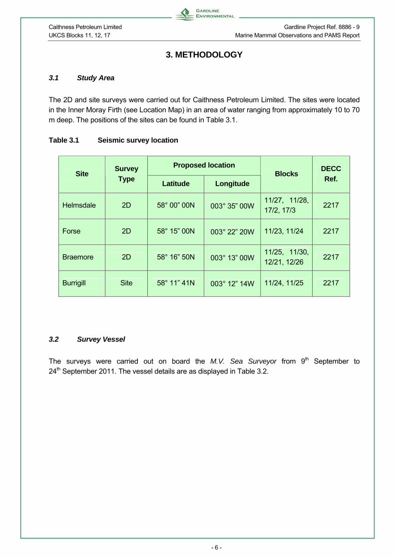
3.1 Study Area
The 2D and site surveys were carried out for Caithness Petroleum Limited. The sites were located in the Inner Moray Firth (see Location Map) in an area of water ranging from approximately 10 to 70 m deep. The positions of the sites can be found in Table 3.1.
Table 3.1 Seismic survey location
Proposed location Site
Survey
Type Latitude Longitude
Blocks DECC
Ref.
Helmsdale 2D 58° 00” 00N 003° 35” 00W 11/27, 11/28, 17/2, 17/3
2217
Forse 2D 58° 15” 00N 003° 22” 20W 11/23, 11/24 2217
Braemore 2D 58° 16” 50N 003° 13” 00W 11/25, 11/30, 12/21, 12/26
2217
Burrigill Site 58° 11” 41N 003° 12” 14W 11/24, 11/25 2217
3.2 Survey Vessel
The surveys were carried out on board the M.V. Sea Surveyor from 9th September to 24th September 2011. The vessel details are as displayed in Table 3.2.

Caithness Petroleum Limited Gardline Project Ref. 8886 - 9 UKCS Blocks 11, 12, 17 Marine Mammal Observations and PAMS Report
- 7 -
Table 3.2 Vessel particulars
Vessel M.V. Sea Surveyor
Class Lloyds – 100 A1 LMC
Flag Bahamas
Length OA 64.4 m
Breadth OA 11.4 m
Draft 3.50 m
Built, rebuilt 1979,1988
Endurance 28 days
Main Engine 2 x Mirrlees Blackstone ESL6, each BHP @ 900 r/m. Driving 2.5:1reversible reduction gearboxes, twin propellers
Thrusters Bow & Stern, 175 HP
Accommodation 38 berths
Owners Gardline Shipping Ltd.
Cruising speed 10 kts
Average trials speed 3-4 kts
3.3 Survey Parameters
The surveys comprised of 2D seismic and high resolution seismic (HRS) and took place between 9th September and 24th September 2011. Survey speed was approximately 4 knots throughout. The objective of the 2D seismic surveys at Helmsdale, Forse and Braemore and the HRS site survey at Burrigill was to undertake an investigation of a potential prospect in the Inner Moray Firth.
3.3.1 High Resolution Seismic Survey
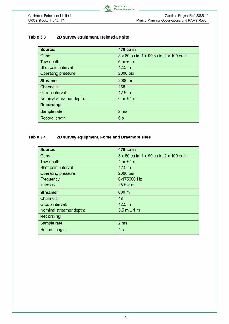
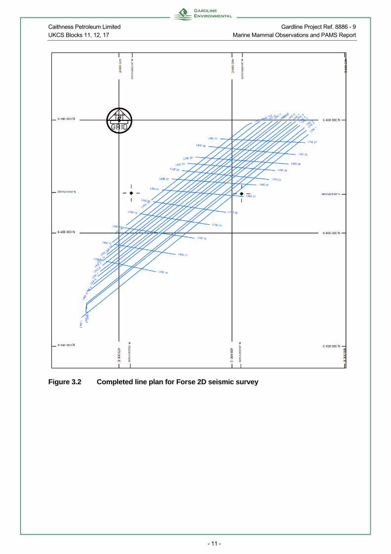
Details of the 2D seismic equipment used to acquire data on the Helmsdale, Forse and Braemore sites can be found in Tables 3.3 and 3.4, while the HRS equipment used on the Burrigill site survey is displayed in Table 3.5. The completed line plans for all four sites are shown in Figures 3.1 to 3.4. The areas surveyed for the 2D seismic surveys at Helmsdale, Forse and Braemore were 16 x 14 km, 12 x 3.5 km and 6 x 8 km respectively and for the site survey at Burrigill 3 x 3 km. All surveys were centred on the proposed locations.
Caithness Petroleum Limited Gardline Project Ref. 8886 - 9 UKCS Blocks 11, 12, 17 Marine Mammal Observations and PAMS Report
- 8 -
Table 3.3 2D survey equipment, Helmsdale site
Source: 470 cu in
Guns 3 x 60 cu in, 1 x 90 cu in, 2 x 100 cu in Tow depth 6 m ± 1 m Shot point interval 12.5 m Operating pressure 2000 psi
Streamer 2000 m
Channels: 168 Group interval: 12.5 m Nominal streamer depth: 6 m ± 1 m
Recording
Sample rate 2 ms
Record length 6 s
Table 3.4 2D survey equipment, Forse and Braemore sites
Source: 470 cu in
Guns 3 x 60 cu in, 1 x 90 cu in, 2 x 100 cu in Tow depth 4 m ± 1 m Shot point interval 12.5 m Operating pressure 2000 psi Frequency 0-175000 Hz Intensity 18 bar m
Streamer 600 m
Channels: 48 Group interval: 12.5 m Nominal streamer depth: 5.5 m ± 1 m
Recording
Sample rate 2 ms
Record length 4 s

Caithness Petroleum Limited Gardline Project Ref. 8886 - 9 UKCS Blocks 11, 12, 17 Marine Mammal Observations and PAMS Report
- 9 -
Table 3.5 Site survey high resolution survey equipment, Burrigill site
Source: 160 cu in
Guns 4 x 40 cu in Tow depth 2.5m ± 1 m Shot point interval 6.25 m Operating pressure 2000 psi Frequency 0-80000 Hz Intensity 10 bar m
Streamer
Channels: 48 Group interval: 12.5 m Nominal streamer depth: 2.5 m ± 1 m
Recording
Sample rate 1 ms
Record length 2 s

Caithness Petroleum Limited Gardline Project Ref. 8886 - 9 UKCS Blocks 11, 12, 17 Marine Mammal Observations and PAMS Report
- 10 -
Figure 3.1 Completed line plan for Helmsdale 2D seismic survey
Caithness Petroleum Limited Gardline Project Ref. 8886 - 9 UKCS Blocks 11, 12, 17 Marine Mammal Observations and PAMS Report
- 11 -
Figure 3.2 Completed line plan for Forse 2D seismic survey

Caithness Petroleum Limited Gardline Project Ref. 8886 - 9 UKCS Blocks 11, 12, 17 Marine Mammal Observations and PAMS Report
- 12 -
Figure 3.3 Completed line plan for the Braemore 2D seismic survey

Caithness Petroleum Limited Gardline Project Ref. 8886 - 9 UKCS Blocks 11, 12, 17 Marine Mammal Observations and PAMS Report
- 13 -
Figure 3.4 Completed HRS line plan for the Burrigill site survey
3.4 Operators Procedures
The surveys were run in accordance with the JNCC’s ‘Guidelines for minimising the risk of injury and acoustic disturbance to marine mammals from seismic surveys, August 2010’ as requested by Caithness Petroleum Limited. These Guidelines require that a watch for marine animals be performed at least 30 minutes prior to the use of airguns (in water less than 200 m deep) or 60 minutes (in water >200 m) prior to the use of airguns during daylight hours. Should marine animals be present within 500 m of the vessel and/or airguns during this period, the start of the source should be delayed by at least 20 minutes after the last sighting to allow animals to move out of the vicinity.

Caithness Petroleum Limited Gardline Project Ref. 8886 - 9 UKCS Blocks 11, 12, 17 Marine Mammal Observations and PAMS Report
- 14 -
The JNCC Guidelines also require that a ‘soft start’ procedure be operated prior to use of the airguns. During this soft start, the source volume is built up slowly from a low energy start-up over a period of 20 minutes before reaching the level required for survey production. It is intended that this slow build up will allow marine animals in the vicinity of the seismic vessel to move away from the area of the airguns. This soft start method was employed during the 2D surveys on the Helmsdale, Forse and Braemore sites. However, due to the nature of the array set up for the Burrigill site survey, it was not possible to build up the array volume due to equipment restraints, so the “decreasing shot point” method of soft start was implemented for this particular site. This procedure means that the array is fired at full volume in an increasingly frequent manner over the period of the soft start. This is deemed acceptable due to the small total volume of the array (160 cu in). According to the JNCC Guidelines, during a survey, if the line turn length is expected to be less than 40 minutes, at the end of each line, the firing frequency should be reduced until the line run in when the firing frequency is increased to that required for shooting the line. If at any point the line turn is expected to be longer than 40 minutes, firing of the guns is stopped and the next line is preceded by a soft start.
3.4.1 Conditions of the PoN14
In addition to the measures laid out in the JNCC’s ‘Guidelines for minimising the risk of injury and acoustic disturbance to marine mammals from seismic surveys, August 2010’ specific conditions were laid out in the PoN14 issued by DECC. Firstly, two MMOs were required to undertake visual monitoring prior to and during all soft start procedures, as well as being available during all daylight seismic operations. Secondly, firing of the airguns was to continue during the course of all line turns regardless of their length. At the end of each survey line, the volume of the airgun discharge was reduced to 60 cu in and the shot point interval extended to 4 minutes, with a standard 20-40 minute soft start required prior to the next line. The PoN14 recommended that the surveys be undertaken in the order: Helmsdale, Forse, Braemore and then Burrigill. At the nearest point, the Braemore 2D survey transect lines were 13 km from the Dornoch Firth and Morrich More SAC, which are designated for harbour seal, otter and habitat features described under Annex I of the EC Habitats Directive. The PoN14 therefore recommended that operations at the Braemore site should commence at the nearest point to the known harbour seal haul-out, so that hauled-out seals would be aware of the survey vessel before any seismic activity commenced. Additionally it was requested in the PoN14 that the consent holder cooperate fully with the University of Aberdeen, in order to facilitate the monitoring work being undertaken by the University during the seismic survey.

Caithness Petroleum Limited Gardline Project Ref. 8886 - 9 UKCS Blocks 11, 12, 17 Marine Mammal Observations and PAMS Report
- 15 -
3.5 Observation Methods
The Marine Mammal Observers carried out dedicated watches for marine animals during seismic operations in daylight hours and completed the relevant recording forms. Watches were primarily carried out from the bridge, the bridge wings and the monkey island. Prior to beginning a watch, the time (UTC) and the weather conditions were recorded on the JNCC Location and Effort Form (Appendix C). Weather conditions such as Beaufort wind force, sea state and visibility were noted whenever a change in conditions occurred. The used definitions of Beaufort wind force and sea state are provided in Appendix B. In addition, the start and end times of marine animal watches and the start and end times of the firing of the airguns were recorded each day on the JNCC Record of Operations Form (Appendix C). The primary observation technique used to spot marine animals was to scan the visible area of sea using the naked eye and scanning areas of interest with binoculars (magnification 10 x 42) (e.g. waves going against the prevailing direction, white water during calm periods, bird activity, bird transiting direction etc.). This technique gave both a wide field of view and the ability to have a sufficient range of 3- 4 km in ideal conditions. Identifications are based on a combination of the observer’s previous experience, aided by the sources listed below:
REID, J.B., EVANS P.G.H., NORTHRIDGE, S.P. 2003. Atlas of Cetacean distribution in north-west European waters. Joint Nature Conservation Committee, Peterborough.
SHIRIHAI, H. & JARRETT, B., 2006. Whales, Dolphins and Seals. A Field guide to the marine mammals of the world. A & C Black Publishers.
The JNCC Marine Mammal Recording Forms were available to record sightings made by the MMOs. The information recorded included the date and time, the vessel’s position, course, depth and seismic activity, the species, number of animals, behaviour, the distance from the vessel and direction of travel. Any additional information, such as details on the features used to identify the animals and the reaction of the animals to the airguns was noted.
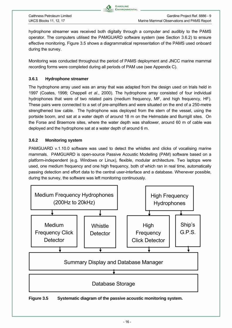
3.6 Acoustic Monitoring
Passive Acoustic Monitoring (PAM) uses hydrophones (underwater microphones) to detect and monitor the presence of vocalising cetaceans. Cetaceans produce a wide variety of sounds which range from the very low frequency vocalisations (down to 15 Hz) of large baleen whales, to extreme high frequency echolocation clicks (up to 130 kHz) used by small cetaceans such as the harbour porpoise. A Passive Acoustic Monitoring System (PAMS) was used to acoustically monitor cetaceans during pre-shooting periods of the surveys, and during all seismic operations. The PAMS utilised a single hydrophone streamer array, described below (Section 3.6.1). The acoustic data from the
Caithness Petroleum Limited Gardline Project Ref. 8886 - 9 UKCS Blocks 11, 12, 17 Marine Mammal Observations and PAMS Report
- 16 -
hydrophone streamer was received both digitally through a computer and audibly to the PAMS operator. The computers utilised the PAMGUARD software system (see Section 3.6.2) to ensure effective monitoring. Figure 3.5 shows a diagrammatical representation of the PAMS used onboard during the survey. Monitoring was conducted throughout the period of PAMS deployment and JNCC marine mammal recording forms were completed during all periods of PAM use (see Appendix C).
3.6.1 Hydrophone streamer
The hydrophone array used was an array that was adapted from the design used on trials held in 1997 (Coates, 1998; Chappell et al., 2000). The hydrophone array consisted of four individual hydrophones that were of two related pairs (medium frequency, MF, and high frequency, HF). These pairs were connected to a set of pre-amplifiers and were situated on the end of a 250-metre strengthened tow cable. The hydrophone was deployed from the stern of the vessel, using the portside boom, and sat at a water depth of around 18 m on the Helmsdale and Burrigill sites. On the Forse and Braemore sites, where the water depth was shallower, around 60 m of cable was deployed and the hydrophone sat at a water depth of around 6 m.
3.6.2 Monitoring system
PAMGUARD v.1.10.0 software was used to detect the whistles and clicks of vocalising marine mammals. PAMGUARD is open-source Passive Acoustic Modelling (PAM) software based on a platform-independent (e.g. Windows or Linux), flexible, modular architecture. Two laptops were used, one medium frequency and one high frequency, both of which ran in real time, automatically passing detection and effort data to the central user-interface and a database. Whenever possible, during the survey, the software was left monitoring continuously.
Figure 3.5 Systematic diagram of the passive acoustic monitoring system.
Medium Frequency Hydrophones (200Hz to 20kHz)
High Frequency Hydrophones
Medium Frequency Click
Detector
Whistle Detector
High Frequency
Click Detector
Ship’s G.P.S.
Summary Display and Database Manager
Database Storage

Caithness Petroleum Limited Gardline Project Ref. 8886 - 9 UKCS Blocks 11, 12, 17 Marine Mammal Observations and PAMS Report
- 17 -
3.7 Communication Procedures
The onboard surveyors and engineers was to notify the MMO/PAMS Operator of planned times for HRS data acquisition and the MMO/PAMS Operator then ensured that monitoring commenced in good time to conduct the required 30 minute pre-piling watch and acoustic monitoring. Any requirements to delay commencement of soft start were communicated to the surveyors and engineers who passed the information onto the Party Chief and then the Caithness Petroleum Ltd Representative. Surveyors or the Officer on the bridge would inform the MMO/PAMS Operator of any changes in operations. The MMO/PAMS Operators were also to hand over all information between out shifts

Caithness Petroleum Limited Gardline Project Ref. 8886 - 9 UKCS Blocks 11, 12, 17 Marine Mammal Observations and PAMS Report
- 18 -
4. RESULTS
4.1 Survey Coverage
The M.V. Sea Surveyor arrived on the Helmsdale site at 20:20h (UTC) on 9th September 2011. The airguns were deployed at 20:44h, and 2D data acquisition began at 21:42h with a soft start. Operations continued uninterrupted until 20:20h on 11th September, when the Helmsdale survey was deemed complete. The survey equipment was recovered and the vessel went down on weather until 08:46h on 12th September. At this time, the Sea Surveyor headed for Inverness for a portcall. On 13th September, the vessel sailed from Inverness at 13:16h, arriving on the Forse site at 18:12h. Upon arrival, the site was assessed during daylight due to its proximity to the coastline, and an SV dip was then done at 19:33h, before the 2D equipment was deployed. Data acquisition began with a soft start, followed by a test line at 01:19h on 14th September and continued until 00:37h on 16th September when the vessel went down on weather and headed for shelter. The vessel returned to site on 17th September and operations recommenced with a soft start at 12:40h on 18th September. Lines were run until 13:53h on 19th September, at which point the vessel moved to the Braemore site. The survey at the Braemore site commenced at 14:30h the same day and continued until 02:58h on 20th September, at which time the vessel returned to the Forse site. Data acquisition continued on the Braemore and Forse sites until these were deemed complete at 02:44h on 20th September and 16:39h on 22nd September respectively. The site survey equipment was deployed on transit to the Burrigill site and work commenced with a soft start at 19:52h on 22nd September and continued until 19:56h on 23rd September when the site was considered complete and the equipment recovered. The vessel then began transit to port arriving in Aberdeen at 13:45h on 24th September. During the Helmsdale survey a total of 14 2D lines were run, these lines were obtained over three days. A total of 26 2D lines were run, including one rerun, at the Forse site, these lines were acquired over a period of nine days. The 2D lines at the Braemore site were acquired over two days, with 12 lines run, including one infill (Table 4.1). During the Burrigill site survey a total of 21 HRS lines were run including two reruns and one gun tests. These lines were obtained over both days of the two-day survey (Table 4.2).

Caithness Petroleum Limited Gardline Project Ref. 8886 - 9 UKCS Blocks 11, 12, 17 Marine Mammal Observations and PAMS Report
- 19 -
Table 4.1 Summary of 2D data acquisition for the Helmsdale, Forse and Braemore
surveys
Data acquisition Helmsdale Forse Braemore
Number 2D lines (inc. infill & reruns) 14 (14) 25 (26) 11 (12)
Number of gun tests 0 2 0
Total hours 2D (hrs:min) 46:30 66:11 21:19
Total km 195.5 180 66.9
Number soft starts 14 27 12
Number daylight soft starts 8 16 9
Average length of soft start (mins) 25 23 21
Average length of line turn (mins) 74 109 83
Table 4.2 Summary of HRS data acquisition for the Burrigill survey
Data acquisition Burrigill
Number HRS lines (inc. Tie line & reruns)
18(20)
Number of gun tests 1
Total hours HRS (hrs:min) 19:47
Total km HRS 57.9
Number soft starts 21
Number daylight soft starts 9
Average length of soft start (mins) 20
Average length of line turn (mins) 31
4.2 Weather Conditions
A total of 27 hours and 40 minutes of dedicated watches were carried out by the MMOs and 45 hours and 24 minutes of PAMS monitoring were carried out by the PAMS operators between 9th September and 11th September on the Helmsdale 2D survey. During the survey swell remained low, sea state was predominantly slight (60%) and visibility varied equally from good to moderate. Wind force ranged from Beaufort force 1 to force 5 and was predominantly force 4 (Figure 4.1). On the Forse site 54 hours and 48 minutes of dedicated watches were carried by the MMOs and 82 hours and 10 minutes of PAMS monitoring were carried out by the PAMS operators between 14th and 22nd September. The weather was highly variable with wind force ranging from Beaufort force 1 to force 8 (predominantly force 3, 30%) and sea state ranged from glassy to rough (Figure 4.2). Swell was low for 97% of the survey and visibility was predominantly good (76%), although periods of moderate or poor visibility were also recorded (Figure 4.3).

Caithness Petroleum Limited Gardline Project Ref. 8886 - 9 UKCS Blocks 11, 12, 17 Marine Mammal Observations and PAMS Report
- 20 -
At the Braemore site, a total of 17 hours and 58 minutes of dedicated watches and 28 hours and 25 minutes of PAMS monitoring were carried out between 19th and 20th September. During the survey swell remained low throughout and visibility was predominantly good (91%), wind force ranged from Beaufort force 2 to 6 and sea state varied from slight to rough being predominantly choppy (Figure 4.4). A total of 10 hours and 50 minutes of dedicated watches were carried out by the MMOs and 26 hours and 9 minutes of PAMS monitoring were carried out by the PAMS operators between 22nd September and 23rd September on the Burigill HRS site survey. During the survey swell remained low, sea state was predominantly choppy (54%) and visibility varied from good to moderate (52% and 48% respectively). Wind force ranged from Beaufort force 3 to force 5 and was predominantly force 4 (Figure 4.5). It should be noted that weather observations were only made during dedicated marine animal observations and hence may not fully reflect the weather throughout the survey.
15%
21%
45%
17%2%
Force 1
Force 2
Force 3
Force 4
Force 5
Figure 4.1 Wind force recorded during dedicated watches on the Helmsdale 2D survey

Caithness Petroleum Limited Gardline Project Ref. 8886 - 9 UKCS Blocks 11, 12, 17 Marine Mammal Observations and PAMS Report
- 21 -
64%
25%
10%1%
Glassy
Slight
Choppy
Rough
Figure 4.2 Sea state recorded during dedicated watches on the Forse 2D survey
76%
22%
2%
Good (>5km)
Moderate (1-5km)
Poor (<1km)
Figure 4.3 Visibility recorded during dedicated watches on the Forse 2D survey

Caithness Petroleum Limited Gardline Project Ref. 8886 - 9 UKCS Blocks 11, 12, 17 Marine Mammal Observations and PAMS Report
- 22 -
47%
50%
3%
Slight
Choppy
Rough
Figure 4.4 Sea state recorded during dedicated watches on the Braemore 2D survey
9%
73%
18%
Force 3
Force 4
Force 5
Figure 4.5 Wind force recorded during dedicated watches on the Burrigill HRS site
survey

Caithness Petroleum Limited Gardline Project Ref. 8886 - 9 UKCS Blocks 11, 12, 17 Marine Mammal Observations and PAMS Report
- 23 -
4.3 Communications
Once onboard the MMO/PAMS Operator relayed all sightings to the surveyors and engineers in the laboratory. If a delay in operations was advised due to the presence of marine animals this information was passed onto the Party Chief and Caithness Petroleum Ltd Representative. The surveyors or the Officer on the bridge communicated any changes in operations to the MMO/PAMS Operator who ensured the required pre-shoot monitoring was completed. All information was handed over between out shifts and no problems in terms of communication were encountered.
4.4 Compliance with JNCC Guidelines
Requirements for MMOs are varied according to the energy source volume, energy source pressure level, sound frequency and survey location. The Moray Firth is considered by the JNCC to be a highly variable area in relation to marine animals so Caithness Petroleum Limited requested the MMOs and PAMS operators to carry out dedicated watches during seismic data acquisition. There were a total of 74 soft starts during the surveys, 42 of these were during daylight hours or low light conditions and full pre-shoot watches were conducted beforehand. All soft starts, whether conducted during day or night, were preceded by a full pre-shoot monitoring period on the PAMS. All soft starts that occurred were between 20 and 40 minutes in length. Communication between the survey team, MMOs and PAMS operators was excellent throughout the surveys. There were no delays to 2D seismic or HRS data acquisition due to marine mammal, marine turtle or basking shark sightings.
4.4.1 Variations to the PoN14
The PoN14 recommended that the sites be run in a particular order (Helmsdale, Forse, Braemore, Burrigill). Due to the layout of the sites and the proximity of the sites to the coast certain lines were only able to be run during daylight hours. So as to not reach a situation where the vessel would be on standby during low light conditions the Braemore site was started before the Forse site was completed and a line plan arranged which allowed for 24 hr operations across both sites.
4.5 Marine Animal Sightings
There were 22 marine mammal sightings throughout the four surveys, from 9th September to 24th September including sightings of northern minke whales, bottlenose dolphins, Risso’s dolphins, harbour porpoises, grey seals and common seals.
4.5.1 Northern minke whale (Balaenoptera acutorostrata)

Caithness Petroleum Limited Gardline Project Ref. 8886 - 9 UKCS Blocks 11, 12, 17 Marine Mammal Observations and PAMS Report
- 24 -
Minkes are distributed from the tropics to the ice edges. The species is frequently seen in inshore northern and western coastal waters of the UK, and occasional records have been reported from the channel coast of mainland Europe. The minke whale is the smallest member of the rorqual family of baleen (filter-feeding) whales reaching a maximum length of 10.7 m (Jefferson et al, 1993). It has a sharply pointed snout, slender, streamlined body, and a tall, falcate dorsal fin, positioned slightly less that 2/3 down the back (Shirihai & Jarrett, 2007). The back of the minke whale is black, brown, or dark grey in colour, whereas the belly and underside of the flippers are usually white. The most conspicuous feature useful in identification, is a diagonal white band on the upper surface of each flipper, however the extent and orientation of this band varies (Shirihai & Jarrett, 2007). The tail flukes are broad and may be pale grey, blue-grey or white on the underside, usually with a dark margin. Minke whales tend to feed on whatever food source is most abundant in a given area, primarily krill and small schooling fish, but occasionally larger fish such as mature Arctic cod and haddock. Feeding minke whales are often seen near the surface chasing fish. The species has been reported to feed in one of two ways: lunge feeding or ‘bird association’ feeding. Minke whales are fast moving and may swim at speeds in excess of 20 km per hour. On surfacing, the dorsal fin typically becomes visible simultaneously with the blow, although the blow is small and not very obvious, even in calm conditions (Shirihai & Jarret, 2007). Minke whales are generally solitary or seen in pairs or threes. However in northern Scotland, aggregations can number 10 to 15 individuals. They are notoriously inquisitive and often approach boats. They are also known to breach more often than other baleen whales, leaping clear of the surface. They are classified as Least Concern on IUCN latest Red List (IUCN, 2009). There was one sighting of a Northern minke whale at 18:07h on 11th September, whilst the M.V. Sea Surveyor was working on the Helmsdale site. The sighting occurred whilst a soft start was being performed prior to a line, and the single individual was seen travelling, approaching the boat at a closest distance of 800 m. A further two minke whales were sighted at the Forse site on 19th September at 07:50h whilst the guns were firing at full power; they were both seen travelling in the opposite direction to the vessel.
4.5.2 Bottlenose Dolphin (Tursiops truncatus)
Bottlenose dolphins are found in all seas throughout the world, occurring quite regularly in coastal waters. The bottlenose dolphin is a large, robust animal with a slightly hooked broad dorsal fin. They have an obvious beak and a pronounced melon (Jefferson et all., 1993). The body colour varies from dark blue to brown grey, fading to a pale grey along the flanks (Shirihai & Jarret, 2007). The bottlenose dolphin can measure up to 4.1 m and weigh up to 650 kg (Shirihai & Jarret, 2007). Bottlenose dolphins are both a coastal and oceanic species, occupying diverse habitats, ranging from rocky reefs to calm lagoons and open waters (Jefferson et al, 1993). They tend to prey on shoaling and bottom-dwelling species, feasting upon a wide variety of fish, squid and octopus. Bottlenose dolphins have been reported individually and are found in groups of between 10-100 inshore and units of several hundred offshore. They are powerful swimmers and acrobatic in nature. They live at least 40 years (approximately) (Shirihai & Jarret, 2007). The estimated current population is unknown, but it is believed to be common, and is listed as Least Concern by IUCN (IUCN, 2009).
There were two sightings of bottlenose dolphins throughout the four surveys. The first sighting occurred whilst the vessel was in transit from the Helmsdale site to Inverness, on 11th September at 11:15h. A pod of 12 dolphins were observed for 15 minutes, breaching and bow-riding the survey vessel. The second sighting occurred at 14:25h on 14th September whilst the vessel was in transit to the Forse site (Figure 4.5). There were 16 dolphins in total, milling approximately 500 m from the vessel.

Caithness Petroleum Limited Gardline Project Ref. 8886 - 9 UKCS Blocks 11, 12, 17 Marine Mammal Observations and PAMS Report
- 25 -
Figure 4.6 Bottlenose dolphins seen on 14th September 2011 in transit to the Forse site
4.5.3 Risso’s Dolphins (Grampus griseus)
Risso’s dolphins are widely distributed throughout temperate and tropical deep oceanic and continental shelf waters. They are robust dolphins, with a blunt head, no distinct beak and a mouth line that slopes upwards. The dorsal fin is tall and falcate, and the flippers are long and pointed. Adult Risso’s range from dark grey to almost white, and are typically covered in white scratches, blotches and spots (Jefferson et al, 1993). The chest has a pale anchor-shaped patch and the appendages such as the fluke and fins tend to be darker in colour than the rest of the body. Due to their extensive scarring, Risso’s tend to be unmistakable from close range, although can be confused with other large dolphin species at a distance. Adult Risso’s dolphins measure at least 3.8 meters in length, and weigh up to 500 kg (Jefferson et al, 1993). Their main prey is squid, but they will also feed on crustaceans and cephalopods (Shirihai & Jarret, 2007). Group sizes tend to be small to moderate, although a group constituting 4,000 individuals has been recorded (Jefferson et al, 1993). Risso’s dolphins, like pilot whales will often associate with other species of cetacean, and bottlenose-Risso’s dolphin hybrids have been reported in the wild as well as in captivity. Risso’s dolphins have been exploited in small numbers throughout their range, and the status of the population is classified as Least Concern by the IUCN (IUCN, 2009).
A mother and juvenile pair of Risso’s dolphins were sighted at 07:37h on 19th September at the Forse site (Figure 4.6). They were seen approximately 100 m from the vessel, crossing the bow whilst the guns were firing at full power. The juvenile dolphin was seen swimming upside down.

Caithness Petroleum Limited Gardline Project Ref. 8886 - 9 UKCS Blocks 11, 12, 17 Marine Mammal Observations and PAMS Report
- 26 -
Figure 4.7 Risso’s dolphins seen on 19th September 2011 at the Forse site
4.5.4 Harbour Porpoise (Phocoena phocoena)
The harbour porpoise is found in cold temperate and sub-arctic waters of the Northern Hemisphere, commonly inhabiting shallow coastal bays, estuaries and tidal channels, but generally only occupying continental shelf waters. It is the smallest cetacean in the Northern Atlantic, measuring just 1.3 to 1.9 m in length and weighing between 45 and 70 kg (Shirihai & Jarret, 2007). It has a short, rotund body with a blunt snout and no obvious beak. The dorsal fin is small and triangular in shape. Colouration is typically dark grey fins and head all the way along the back to the flukes. The flanks gradually merge from dark grey to white on the undersides. Harbour porpoise appear to feed upon a variety of fish and cephalopods; their diet varying with location and availability of prey items. The species usually hunts singly or in small groups, but they may form loose aggregations if there is a large amount of food, despite still tending to feed semi-independently. Harbour porpoises are usually seen in small groups of less than ten animals. The swimming motion of the harbour porpoise is generally inconspicuous, involving surfacing with a rolling motion (Shirihai & Jarret, 2007), and their small size make it difficult to observe these animals in all but calm sea conditions. Moreover, the species is notoriously shy and generally avoids approaching boats. Their conservation status is classed as Least Concern on the IUCN Red List (IUCN, 2009), and they are listed on Annex II and IV of the EU Habitats Directive.
On the Forse site, there were three sightings of harbour porpoises on 15th September, at 07:04h, 08:28h and 08:41h (Figure 4.7), while the vessel was on a line turn and the guns were firing at reduced power. Group size ranged from three to six animals and the first group contained one juvenile. At 10:31h on 21st September a group of three harbour porpoises were seen transiting across the bow of the vessel whilst the vessel was standing by on weather.

Caithness Petroleum Limited Gardline Project Ref. 8886 - 9 UKCS Blocks 11, 12, 17 Marine Mammal Observations and PAMS Report
- 27 -
Figure 4.8 Harbour porpoise seen on 15th September 2011 at the Forse site.
4.5.5 Common Seal (Phoca vitulina)
The common seal is one of the most widespread of all the pinnipeds. They are found in the Northern Hemisphere from temperate to Polar regions. The common seal has a stout body and the head is small and cat-like (Jefferson et al, 1993). The nostrils are small, forming a “V” that meets at the bottom, and it has large eyes (Shirihai & Jarret, 2007). They are light to dark grey-brown with fine spots, ring-like markings and some blotches (Jefferson et al, 1993. Common seals are not sexually dimorphic and reach up to 2m in length and weigh between 70 – 170kg (Shirihai & Jarret, 2007). The common seal feeds on a wide variety of fish species, cephalopods and crustaceans. . Common seals are gregarious and gather together for breeding, moulting and hauling out. The common seal is currently listed as a protected species under Annex II and Annex V of the European Habitats Directive, they are considered Least Concern on IUCN Red List (IUCN, 2009).
One common seal was sighted at 08:45h on 15th September at the Forse site (Figure 4.8). It surfaced approximately 150 m from the vessel and swam in a south-easterly direction for two minutes before disappearing again. A second common seal was sighted at the Forse site on 19th September at 05:50h, approximately 300 m from the vessel. Both sightings occurred whilst the guns were firing at reduced power during line turns.
4.5.6 Grey Seal (Halichoerus grypus)
There are three main populations of grey seal in the World, found in the eastern Atlantic, western Atlantic and the Baltic Sea. The eastern Atlantic stock occurs in Iceland, the Faroe Islands, in Norway and around the British Isles. The grey seal has very pronounced sexual dimorphism. Males are dark with light patches and are up to 2.3m in length and up to 310kg in weight (Jefferson et al, 1993). While females are light coloured with dark spots, and are much smaller, reaching up to 2m in length and weighing up to 190 kg (Jefferson et al,

Caithness Petroleum Limited Gardline Project Ref. 8886 - 9 UKCS Blocks 11, 12, 17 Marine Mammal Observations and PAMS Report
- 28 -
1993). The distinctive muzzle is particularly long, rectangular, and its shape has led to the common name “horsehead.”. In adult males, the top of the muzzle is convex. In adult females and subadults, it is more flat or slightly concave (Jefferson et al, 1993). The nostrils are widely separated and almost parallel to each other (Shirihai & Jarret, 2007). The grey seal feeds on local inshore fish species, cephalopods and crustaceans such as dab, sole, sand eel, cod and whiting (IUCN, 2009). Many of the fish species in the grey seals' diet are commercially exploited, so there can be competition for resources with the fisheries. Grey seals are gregarious and gather together for breeding, moulting and hauling out. The grey seal is currently listed as a protected species under Annex II and Annex V of the European Habitats Directive. They are considered Least Concern on IUCN Red List (IUCN, 2009).
A total of 10 grey seals were sighted during the four surveys. On the Forse site, three grey seals were sighted on 15th September (Figure 4.9). The first was seen at 09:53h, sleeping approximately 300 m from the vessel, the second was seen at 10:16h and surfaced for 10 minutes whilst the third was seen at 16:48h during a soft start and came within 300 m of the guns. A further six sightings of grey seals occurred at the Forse site on 19th September between 05:50h and 08:46h. All sightings were within 300 m of the vessel and five occurred whilst the vessel was on a line turn and guns were at reduced power. The other sighting occurred whilst the guns were at full power, and the seal was seen eating a fish at the surface. There was one sighting of a grey seal on the Braemore site on 19th September at 16:27h. This occurred during a line turn when the guns were at reduced power and the seal was seen porpoising across the bow of the vessel.
Figure 4.9 Grey seal seen on 15th September 2011 at Forse site.

Caithness Petroleum Limited Gardline Project Ref. 8886 - 9 UKCS Blocks 11, 12, 17 Marine Mammal Observations and PAMS Report
- 29 -
4.6 Acoustic Detections
Throughout the duration of survey from 9th September to 24th September, 108 hours and 10 minutes of PAM effort was recorded. On 19th September, acoustic detections were made from 07:38h to 07:42h of the mother and juvenile Risso’s dolphins. Both the medium and high frequency spectrograms showed echolocation clicks (Figure 4.10).
Figure 4.10 Detection of Risso’s dolphins’ echolocation clicks on 19th September 2011. Frequency range is depicted in kHz on the right hand scale and amplitude in dB on the left hand scale

Caithness Petroleum Limited Gardline Project Ref. 8886 - 9 UKCS Blocks 11, 12, 17 Marine Mammal Observations and PAMS Report
- 30 -
5. DISCUSSION
5.1 Marine Animal Detection
There were a number of factors that may have influenced the detection of marine animals within the survey area. Weather can affect the ability to detect marine animals in a number of ways, with increasing sea state, wind force and decreasing visibility reducing the detection probability of marine animals (Forney, 2000) particularly those with inconspicuous surfacing behaviour like harbour porpoise (Northridge et al, 1995; Palka, 1996). The weather conditions were predominantly good to moderate, however there were also some periods of high winds, poorer visibility and choppy to rough seas. These poor weather conditions would have reduced the ability of the MMOs to visually detect marine animals and therefore some animals within the area may not have been recorded. In support of this the majority of sightings throughout these surveys occurred during good weather conditions. In particular, the harbour porpoise is one of the commonly recorded species in the area (Bailey & Thompson, 2009) but is known for its elusive nature and inconspicuous surfacing behaviour (Shirihai & Jarrett, 2006). The weather conditions should not, however have affected the ability of the PAMS to detect vocalising marine animals. The spatio-temporal distribution and the high mobility of marine animals may have had an effect on detection. Cetaceans migrate at certain times of the year, primarily in relation to prey abundance and distribution, breeding opportunities and availability of space (Northridge et al, 1995; Stern, 2002). Studies indicate that within the Moray Firth the bottlenose dolphin population may be highly mobile and also undertake distinct seasonal movements. Whilst the coastal margins in the outer part of the Inner Moray Firth are used most of the year (Hastie et al, 2003), sightings of dolphins are concentrated, particularly during the summer months from June to September, in three main areas at the head of the Firth (Wilson et al, 1997). This increase in the numbers of dolphins is due to a stratified movement of all individuals rather than an influx of incomers to the resident population (Wilson et al, 1997) and this movement is related to foraging (Hastie et al, 2004). Further research has also indicated that areas along the southern Outer Moray Firth also represent an important part of the bottlenose dolphin’s habitat (Culloch & Robinson, 2008) and that the species may have expanded its range beyond the Inner Moray Firth area since the 1980s (Wilson et al, 2004). Whilst the occurrence of harbour porpoise is more dispersed through the Inner Moray Firth area (Hastie et al, 2003; Bailey & Thompson, 2009) their distribution is also related to various environmental variables (Bailey & Thompson, 2009). Studies suggest that that the influence of these variables is related to their effects on prey distribution (Johnston et al, 2005). However recent discoveries that bottlenose dolphins attack and kill harbour porpoises in the area (Ross & Wilson, 1996) cannot exclude the possibility that porpoises are actively avoiding areas with higher dolphin densities. Although sighted regularly in the offshore areas of the Inner Moray Firth, few studies have related minke whale sightings to environmental variables due to small sample sizes (Bailey & Thompson, 2009). However studies in the southern Outer Moray Firth indicate minke whale distribution is influenced by physiographic features particularly water depth and sediment type (Robinson et al,

Caithness Petroleum Limited Gardline Project Ref. 8886 - 9 UKCS Blocks 11, 12, 17 Marine Mammal Observations and PAMS Report
- 31 -
2009) and mesoscale oceanographic features (Tetley et al, 2008) through the influence on prey distribution. Similar to cetaceans the distribution and movement of seals is also related to prey abundance and availability (Thompson & Miller, 1990; Thompson et al, 1991; McConnell et al, 1999). However in contrast to cetaceans seal distribution is also related to haul-out and breeding sites (Thompson et al, 1996) with seals often returning to the same haul-out sites (Thompson & Miller, 1990; McConnell et al, 1999). Foraging distances varies between species: common seals forage within 60 km of haul-out sites whilst grey seals are more likely to forage over wider distances, up to 145 km from sites (Thompson et al, 1996). Movements between haul-out sites also vary with common seals moving to alternative sites within a range of 75 km, whilst grey seals have been reported moving to sites 125 – 365 km away indicating regular interchange between the Moray Firth, Orkney and the Farne Islands (Thompson et al, 1996). The high mobility and movement of marine animals within the survey area and between other areas, means that species may not have been present or present in abundance during the survey period.
5.2 Marine Animal Observation
Marine animal research carried out previously within the waters of the Inner Moray Firth has recorded a range of cetacean species occurring throughout the year (Thompson et al, 2010). While these species can occur in spatially distinct areas (Hastie et al, 2003; Bailey & Thompson, 2009) and therefore not necessarily in the current survey area, it must be remembered that marine animals are highly mobile. It was therefore anticipated that marine animal sightings were possible, and as such MMO duties and passive acoustic monitoring were carried out during all seismic data acquisition. During the 2D seismic survey, between 29th August and 9th September 2011, there were 14 sightings of marine animals. These sightings consisted of six different species, five of which are commonly seen within the Inner Moray Firth; bottlenose dolphins, harbour porpoise, minke whale, grey seal and common seal (Thompson et al, 1996; Hastie et al, 2003; Bailey & Thompson, 2009). Gardline Environmental supports the use of two MMOs during long daylight hours in the summer months and in such an ecologically sensitive area, in conjunction with 24-hour PAMS monitoring.

Caithness Petroleum Limited Gardline Project Ref. 8886 - 9 UKCS Blocks 11, 12, 17 Marine Mammal Observations and PAMS Report
- 32 -
6. REFERENCES
ADAMS, J.A. AND MARTIN, J.H.A. 1986. The hydrography and plankton of the Moray Firth. The
Marine Environment of the Moray Firth (ed. HAWTHORN, J.), pp 37-56. Royal Society of Edinburgh, Edinburgh.
BAILEY, H. AND THOMPSON, P.M. 2009. Using marine mammal habitat modelling to identify priority
conservation zones within a marine protected area. Marine Ecology Progress Series, 378: 279-287.
BARTOL, S.M., MUSICK, J.A. AND LENHARDT, M.L. 1999. Auditory Evoked Potentials of the
Loggerhead Sea Turtle (Caretta caretta). Copeia, 3:836-840. BLOOMFIELD, A. & SOLANDT, J. 2007. The Marine Conservation Society Basking Shark Watch.
http://www.mcsuk.org/downloads/wildlife/basking_sharks/BSW20%20Report.pdf Viewed on 18/08/2011.
BUTLER, J.R.A. 2004. Moray Firth Seal Management Plan. A Pilot Project for Managing Interactions
Between Seals and Salmon in Scotland. Spey District Salmon Fishery Board, Aberlour (pp 64).
CASPER, B.M. & MANN, D.A. 2006. Dipole hearing measurements in elasmobranch fishes. Journal of Experimental Biology, 210: 75- 81.
CHAPPELL, O., LEWIS, T., GILLESPIE, D., SWIFT, R., BOISSEAU, O. AND GORDON, J., 2000. The development of acoustic techniques for cetacean monitoring on the guard vessel Hunter, 1998. Report submitted to Shell UK Ltd.
CLARK, C.W. & GAGNON, G.C. 2006. Considering the temporal and spatial scales of noise exposures from seismic surveys on baleen whales. Paper SC/58/E9 presented to the IWC Scientific Committee, June 2006.
COATES, R., 1998. Report on Cetacean Array Fabrication. Report submitted to Shell UK Ltd.
CULLOCH, R.M. AND ROBINSON, K.P. 2008. Bottlenose dolphins using coastal regions adjacent to a Special Area of Conservation in north-east Scotland. Journal of the Marine Biological Association of the United Kingdom, 88: 1237-1243.

Caithness Petroleum Limited Gardline Project Ref. 8886 - 9 UKCS Blocks 11, 12, 17 Marine Mammal Observations and PAMS Report
- 33 -
DERUITER, S.L., TYACK P.L.. Lin, Y.T., Newhall, A.E., Lynch J.F., Miller P.J.O. 2006. Modeling acoustic propagation of airgun array pulses recorded on tagged sperm whales (Physeter macrocephalus). The Journal of the Acoustical Society of America, 120(6): 4100- 4114.
EISFIELD, S., KEITH, S., POPE, A., STILL, D., DOLMAN, S. AND SIMMONDS, M. 2009. Outer Moray Firth Cetacean Research 2008. Project report for the BBC Wildlife Fund. Whale and Dolphin Conservation Society.
ELEFTHERIOU, A., BASFORD, D. AND MOORE, D.C. 2004. Synthesis of Information on the Benthos of Area SEA 5. Report for the Department of Trade and Industry (pp 84)
ELLETT, D.J. & BLINDHEIM, J. 1992. Climate and hydrographic variability in the ICES area during the 1980s. ICES Marine Science Symposium, 195: 11- 31.
EVANS, P.G.H. 1990. European cetaceans and seabirds in an oceanographic context. Lutra, 33: 95- 125.
EVANS, P.G.H. AND NICE, H. 1996. Review of the effects of underwater sound generated by seismic surveys on cetaceans. Sea Watch Foundation Publications, Oxford.
FINNERAN, J.J., SCHLUNDT, C.E., DEAR, R., CARDER, D.A. & RIDGWAY S.H. 2002. Temporary shift in masked hearing thresholds in odontocetes after exposure to single underwater impulses from a seismic watergun. The Journal of the Acoustical Society of America, 111(6): 2929- 2940.
FORNEY, K.A. 2000. Environmental models of cetacean abundance: reducing uncertainty in population trends. Conservation Biology, 14: 1271-1286.
FOSTER-SMITH, R., SOTHERAN, I. AND FOSTER-SMITH, D. 2009. Sublittoral Biotope Mapping of the Moray Firth SAC. Scottish Natural Heritage Commissioned Report No. 338. Scottish Natural Heritage, Inverness (pp 166).
FRIEDLAENDER, A.S., HALPIN, P.N., QIAN, S.S., LAWSON, G.L., WIEBE, P.H., THIELE, D. AND READ, A.J. 2006. Whale distribution in relation to prey abundance and oceanographic processes in shelf waters of the Western Antarctic Peninsula. Marine Ecology Progress Series, 317: 297-310.

Caithness Petroleum Limited Gardline Project Ref. 8886 - 9 UKCS Blocks 11, 12, 17 Marine Mammal Observations and PAMS Report
- 34 -
GORDON, J., GILLESPIE, D., POTTER, J., FRANTZIS, A., SIMMONDS, M., SWIFT, R. & THOMPSON, D. 2003. A review of the effects of seismic surveys on marine mammals. Marine Technology Society Journal, 37(4): 16- 34.
GOTZ, T., HASTIE, G., HATCH, L.T., RAUSTEIN, O., SOUTHALL, B.L. & TASKER, M. 2009. Overview of the impacts of anthropogenic sound. Ospar commission.
GREENSTREET, S.P.R., MCMILLAN, J.A. AND ARMSTRONG, E. 1998. Seasonal variation in the importance of pelagic fish in the diet of piscivorous fish in the Moray Firth, NE Scotland: a response to variation in prey abundance? ICES Journal of Marine Science, 55:121-133.
HASTIE, G.D., BARTON, T.R., GRELLIER, K., HAMMOND, P.S., SWIFT, R.J., THOMPSON, P.M. AND
WILSON, B. 2003. Distribution of small cetaceans within a candidate Special Area of Conservation: implications for management. Journal of Cetacean Research and Management, 5:261-266.
HASTIE, G.D., WILSON, B., WILSON, L.J., PARSONS, K.M. AND THOMPSON, P.M. 2004. Functional mechanisms underlying cetacean distribution patterns: hotspots for bottlenose dolphins are linked to foraging. Marine Biology, 144: 397-403.
HOLMES, R., BULAT, J., HENNI, P., HOLT, J., JAMES, C., KENYON, N., LESLIE, A., LONG, D., MORRI, C., MUSSON, R., PEARSON, S. AND STEWART, H. 2004. DTI Strategic Environmental Assessment Area 5 (SEA 5): Seabed and superficial geology and processes. British Geological Survey Report CR/04/064N, British Geological Survey, Edinburgh.
HUNT, JR., G.L. & SCHNEIDER, D.C. 1987. Scale dependant processes in the physical and biological environment of marine birds. In Seabirds: Feeding ecology and role in marine ecosystems, ed., Croxall, J.P. pp 7- 41. Cambridge University Press, Cambridge.
INTERNATIONAL UNION FOR THE CONSERVATION OF NATURE AND NATURAL RESOURCES 2011. IUCN Red List of Threatened Species. Version 2011.1.
JEFFERSON, T.A., LEATHERWOOD, S. & WEBBER, M.A. 1993. FAO species identification guide. Marine Mammals of the World. FAO, Rome.
JOHNS, D. 2004. Plankton Report for Strategic Environment Assessment Area 5. Contract for the Department of Trade and Industry (pp 29).

Caithness Petroleum Limited Gardline Project Ref. 8886 - 9 UKCS Blocks 11, 12, 17 Marine Mammal Observations and PAMS Report
- 35 -
JOHNSTON, D.W., WESTGATE, A.J. AND READ, A.J. 2005. Effects of fine-scale oceanographic features on the distribution and movements of harbour porpoises Phocoena phocoena in the Bay of Fundy. Marine Ecology Progress Series, 295: 279-293.
KASTELEIN, R.A., JENNINGS, N., VERBOOM, W.C., DE HAAN, D. AND SCHOONEMAN, N.M. 2006. Differences in the response of a striped dolphin (Stenella coeruleoalba) and a harbour porpoise (Phocoena phocoena) to an acoustic alarm. Marine Environmental Research, 61: 363-378.
KOSCHINSKI, S., CULIK, B.M., DAMSGAARD HENRIKSEN, O., TREGENZA, N., ELLIS, G., JANSEN, C. AND
KATHE, G. 2003. Behavioural reactions of free-ranging porpoises and seals to the noise of a simulated 2 MW windpower generator. Marine Ecology Progress Series, 265: 263-273.
LE FÈVRE, J. 1986. Aspects of the biology of frontal systems. Advances in Marine Biology, 23: 163-299.
LEENEY, R.H., BERROW, S., MCGRATH, D., O’BRIEN, J., COSGROVE, R. AND GODLEY, B. 2007. Effects of pingers on the behaviour of bottlenose dolphins. Journal of the Marine Biological Association of the United Kingdom, 87: 129-133.
LUCKE, K., SIEBERT, U., LEPPER, P. A. & BLANCHET, M.-A. 2009. Temporary shift in masked hearing thresholds in a harbour porpoise (Phocoena phocoena) after exposure to seismic airgun stimuli. The Journal of the Acoustical Society of America, 125(6): 4060- 4070.
MACLEOD, K., FAIRBAIRNS, R., GILL, A., FAIRBAIRNS, B., GORDON, J., BLAIR-MYERS, C. AND
PARSONS, E.C.M. 2004. Seasonal distribution of minke whales Balaenoptera acustorostrata in relation to physiography and prey off the Isle of Mull, Scotland. Marine Ecology Progress Series, 277: 263-274.
McConnell et al. 1999. Movements and foraging areas of grey seals in the North Sea. Journal of Applied Ecology, 36: 573-590.
MENDES, S., TURRELL, W., LÜTKEBOHLE, T. AND THOMPSON, P. 2002. Influence of the tidal cycle and a tidal intrusion front on the spatio-temporal distribution of coastal bottlenose dolphins. Marine Ecology Progress Series, 239: 221-229.
MORAY FIRTH SAC MANAGEMENT GROUP. 2009. The Moray Firth Special Area of Conservation Management Scheme, Revision 2. The Moray Firth Partnership, Inverness (pp 86).
MORTON, A. B. & SYMONDS, H. K. 2002. Displacement of Orcinus orca (L.) by high amplitude sound in British Columbia, Canada. ICES Journal of Marine Science, 59(1): 71- 80.
Caithness Petroleum Limited Gardline Project Ref. 8886 - 9 UKCS Blocks 11, 12, 17 Marine Mammal Observations and PAMS Report
- 36 -
NRC (NATIONAL RESEARCH COUNCIL) 2005. Marine mammal populations and ocean noise: Determining when noise causes biologically significant effects, The National Academies Press, Washington DC.
NIEUKIRK, S.L., STAFFORD K.M., MELLINGER, D.K., DZIAK, P. & FOX, C.G. 2004. Low frequency whale and seismic airgun sounds recorded in the mid-Atlantic Ocean. The Journal of the Acoustical Society of America, 115(4): 1832- 1843.
NORTHRIDGE S. P., TASKER, M. L., WEBB, A., WILLIAMS, J, M., 1995. Distribution and relative
abundance of harbour porpoises (Phocena phocena L.), white-beaked dolphins (Lagenorhynchus albirostris Gray), and minke whales (Balaenoptera acutorostrata Lacepede) around the British Isles. Journal of Marine Science, 52: 55– 66.
PALKA, D. 1996. Effects of Beaufort Sea State on the Sightability of Harbor Porpoises in the Gulf of
Maine. Reports of the International Whaling Commission, 46: 575-582.
REID, J. B., EVANS, P.G.H. & NORTHRIDGE, S.P. 2003. Atlas of Cetacean distribution in north-west European Waters. Peterborough, Joint Nature Conservation Committee.
ROBINSON, K.P., TETLEY, M.J. AND MITCHELSON-JACOB, E.G. 2009. The distribution and habitat preference of coastally occurring minke whales (Balaenoptera acutorostrata) in the outer southern Moray Firth, northeast Scotland. Journal of Coastal Conservation, 13:39-48.
ROSS, H.M. AND WILSON, B. 1996. Violent interactions between Bottlenose Dolphins and Harbour Porpoises. Proceedings of the Royal Society B, 263: 283-286.
SEA WATCH FOUNDATION. 2011. News Archive. Available: http://www.seawatchfoundation.org.uk/newsarchive.php
Last accessed 21/09/2011.
SHIRIHAI, H. & JARRETT, B. 2006. Whales, Dolphins and Seals. A Field guide to the marine mammals of the world. A & C Black Publishers.
STERN, J. 2002. Migration and Movement Patterns. In: Marine Mammals, ed., Perrin, W. F., Wursig
B, Thewissen, J. G. M., pp 742– 749. Academic Press San Diego, USA. STONE, C.J. AND TASKER, M.L. 2006. The effects of seismic airguns on cetaceans in UK waters.
Journal of Cetacean Research and Management, 8: 255-263. TEILMANN, J., TOUGAARD, J., CARSTENSEN, J., DIETZ, R., TOUGAARD, S. 2006. Summary on seal
monitoring 1999-2005 around Nysted and Horns Rev Offshore Wind Farms. Technical report to Energi E2 A/S and Vattenfall A/S.

Caithness Petroleum Limited Gardline Project Ref. 8886 - 9 UKCS Blocks 11, 12, 17 Marine Mammal Observations and PAMS Report
- 37 -
TETLEY, M.J., MITCHELSON-JACOB, E.G. AND ROBINSON, K.P. 2008. The summer distribution of coastal minke whales (Balaenoptera acutorostrata) in the southern outer Moray Firth, NE Scotland, in relation to co-occurring mesoscale oceanographic features. Remote sensing of Environment, 112: 3449-3454.
THOMPSON, P.M. AND MILLER, D. 1990. Summer foraging activity and movements of radio-tagged common seals (Phoca vitulina. L.) in the Moray Firth, Scotland. Journal of Applied Ecology, 27: 492-501.
THOMPSON, P.M. & OLLASON, J.C. 2001. Lagged effects of ocean climate change on fulmar population dynamics. Nature, 413: 417- 420.
THOMPSON, P.M., PIERCE, G.J., HISLOP, J.R.G., MILLER, D. & DIACK, J.S.W. 1991. Winter foraging by common seals (Phoca vitulina) in relation to food availability in the inner Moray Firth, N.E. Scotland. Journal of Animal Ecology, 60: 283-294.
THOMPSON, P.M., MCCONNELL, B.J., TOLLIT, D.J., MACKAY, A., HUNTER, C. AND RACEY, P.A.
1996. Comparative distribution, movements and diet of harbour and grey seals from the Moray Firth, N.E. Scotland. Journal of Applied Ecology, 33: 1572-1584.
THOMPSON, P.M., BROOKES, K., CHENEY, B., CÂNDIDO, A., BATES, H., RICHARDSON, N. & BARTON,
T. 2010. Assessing the potential impact of oil and gas exploration operations on cetaceans in the Moray Firth. University of Aberdeen report for DECC, Scottish Government, Cowrie and Oil & Gas UK.
WHALEY, A.R. 2004. The distribution and relative abundance of the harbour porpoise (Phocoena phocoena L.) in the southern outer Moray Firth, NE Scotland. Thesis (BSc.), Birkbeck College, University of London.
WILSON, B., THOMPSON, P.M. AND HAMMOND, P.S. 1997. Habitat use by bottlenose dolphins:
seasonal distribution and stratified movement patterns in the Moray Firth, Scotland. Journal of Applied Ecology, 34:1365-1374.
WILSON, B., REID, R.J., GRELLIER, K., THOMPSON, P.M. AND HAMMOND, P.S. 2004. Considering the
temporal when managing the spatial: a population range expansion impacts protected areas-based management for bottlenose dolphins. Animal Conservation, 7: 331-338.

Caithness Petroleum Limited Gardline Project Ref. 8886 - 9 UKCS Blocks 11, 12, 17 Marine Mammal Observations and PAMS Report
- 38 -
7. APPENDICES
Appendix A – JNCC guidelines for minimising the risk of injury and disturbance to marine
mammals from seismic surveys August 2010 The guidelines have been written for activities on the United Kingdom Continental Shelf and are aimed at minimising the risk of injury and acoustic disturbance from seismic surveys to marine mammals including seals, whales, dolphins and porpoises. Whilst there are no objections to these guidelines being used out-with UK waters JNCC would encourage all operators to determine if any special or local circumstances pertain, as we would not wish these guidelines to be used where a local management tool has already been adopted (for instance in the Gulf of Mexico OCS Region). In this context, JNCC notes that other fauna, for example turtles, occur in waters where these guidelines may be used, and would suggest that, whilst the appropriate mitigation may require further investigation, the soft-start procedures for marine mammals would also be appropriate for marine turtles and basking sharksi. The guidelines require the use of trained Marine Mammal Observers (MMOs) whose role is to advise on the use of the guidelines and conduct pre-shooting searches for marine mammals before commencement of any seismic activity. A further duty is to ensure that the JNCC reporting forms are completed for inclusion in the MMO report. In addition to the visual mitigation provided by MMOs, if seismic surveys are planned to start during hours of darkness or low visibility it is considered best practice to deploy Passive Acoustic monitoring (PAM). The 2010 version of the JNCC seismic guidelines reflects amendments (2007 and 2009 amendments) to the Conservation (Natural Habitats &c.) Regulations 1994 (Habitat Regulations, HR) for England and Walesii and the Offshore Marine Conservation (Natural Habitats, &c.) Regulations 2007 (Offshore Marine Regulations, OMR, as amended in 2009 and 2010). Both regulations have revised the definition of deliberate disturbance of ‘European Protected Species’ (EPS), which now excludes trivial disturbance from the offence. Both regulations now also include the offence of deliberate injury. European Protected Species include cetaceans and turtles. It has been recognised that sound generated from seismic sources has the potential to cause injury and possibly also disturbance to marine mammals. Seismic surveys have therefore the potential to cause a deliberate injury offence as defined under regulations 41(1)(a) and 39(1)(a) and a deliberate disturbance offence as in 41(1)(b) and 39(1)(b) of the HR and OMR, respectively. The JNCC seismic guidelines reflect best practice for operators to follow during the planning, operational and reporting stages. It is considered that compliance with the recommendations in these guidelines will reduce the risk of injury to EPS to negligible levels. Please note that the mitigation measures recommended in the existing guidelines are more relevant to the prevention of injury rather than disturbance as defined in regulations 41(2) and 39(1A), of the HR and OMR, respectively. The onus should be on the entity responsible for the activity to assess whether a disturbance offence is likely to occur. Guidance on how to carry out such risk assessment is provided in the JNCC, NE and CCW document ‘The protection of marine European Protected Species from injury and disturbance’. In relation to oil and gas seismic surveys in the UKCS, it is a requirement of the consent issued under regulation 4 of the Petroleum Activities (Conservation of Habitats) Regulations 2001 (& 2007 Amendments) by the Department for Energy Climate Change (DECC), that the JNCC Seismic Guidelines must be followed, and the elements of the guidelines that are relevant to a particular

Caithness Petroleum Limited Gardline Project Ref. 8886 - 9 UKCS Blocks 11, 12, 17 Marine Mammal Observations and PAMS Report
- 39 -
survey are incorporated into the legally-binding condition of consent. It should be noted that it is the responsibility of the company issued consent by DECCiii, referred to in these guidelines as the ‘applicant’, to ensure that these guidelines are followed, and it is recommended that a copy of the JNCC guidelines are available onboard all vessels undertaking seismic activities in UK waters. Where relevant, when the survey is completed a MMO report must be submitted to the JNCC. i Basking sharks are protected from intentional capture or disturbance in British waters (up to 12 miles offshore) under a 1998 listing on the Wildlife and Countryside Act (1981), Schedule 5. ii In 2010 a consolidated version of the regulations came into force: The Conservation of Habitats and Species Regulations 2010. iii Department of Energy and Climate Change was formerly known as Department for Business and Regulatory Reform
(BERR)
Caithness Petroleum Limited Gardline Project Ref. 8886 - 9 UKCS Blocks 11, 12, 17 Marine Mammal Observations and PAMS Report
- 40 -
Index
Section 1 – Assessing and minimising the risk of injury
1.1 The planning stage
Section 2 – Marine Mammal Observers (MMOs)
2.1 Role of the MMO
2.2 Training requirements for MMOs
2.3 MMO equipment and reporting forms
2.4 Reporting requirements – the MMO report
Section 3 – Guidance before and during seismic activity
3.1 Pre-shooting search
3.2 Delay if marine mammals are detected within the mitigation zone (500 metres)
3.3 The soft-start
3.3.1 Soft-start requirements for site survey or Vertical Seismic Profiling (VSP)
3.3.2. Soft-starts and airgun testing
3.4 Line change
3.4.1 Seismic surveys with an airgun volume of 500 cubic inches or more
3.4.2 Seismic surveys with an airgun volume of 180 cubic inches or less
3.5 Undershoot operations
Section 4 – Acoustic monitoring
4.1 Use of PAM as a mitigation tool
Section 5 – Requirements for MMOs and PAM
Section 6 – Background Information
6.1. Existing protection to cetaceans
Section 7 – References and contacts
Caithness Petroleum Limited Gardline Project Ref. 8886 - 9 UKCS Blocks 11, 12, 17 Marine Mammal Observations and PAMS Report
- 41 -
Terminology
Marine European Protected Species: These are marine species in Annex IV(a) of the Habitats Directive that occur naturally in the waters of the United Kingdom. These consist of several species of cetaceans (whales, dolphins and porpoises), turtles, and the Atlantic Sturgeon.
Marine Mammal Observer (MMO): Individual responsible for conducting visual watches for marine mammals. For some seismic surveys it may be requested that observers are trained, dedicated and / or experienced. The MMO may also be a PAM operative if trained.
Trained MMO: Has been on a JNCC recognised course
Dedicated MMO: Trained observer whose role on board is to conduct visual watches for marine mammals (although it could double up as a PAM operative)
Experienced MMO: Trained observer with 3 years of field experience observing for marine mammals, and practical experience of implementing the JNCC guidelines
PAM Operative: Person experienced in the use of PAM software and hardware and marine mammal acoustics
Mitigation Zone: The area where a Marine Mammal Observer keeps watch for marine mammals (and delays the start of activity should any marine mammals be detected).
Passive Acoustic Monitoring (PAM): Software system that utilises hydrophones to detect the vocalisations of marine mammals.
Seismic Survey: Any survey that uses airguns, including 2D/3D/4D and OBC (On-Bottom Cabling) surveys and any similar techniques that use airguns. Surveys using multibeam systems and sub-bottom profiling equipment such as boomers, pingers etc are not considered in these guidelines. However, the guidelines can be adapted and applied to the operation of such systems if considered appropriate.
Shot Point Interval (SPI): Interval between firing of the airgun or airguns.
Site Survey: Seismic survey of a limited area proposed for drilling, infrastructure emplacement etc (typically with source size of 180 cubic inches or less).
Soft-Start: Turning on the airguns at low power and gradually and systematically increasing the output until full power is achieved (usually over a period of 20 minutes). The appropriate soft-start method is dependant upon the type of seismic survey and is discussed in section 3.
United Kingdom Waters: Parts of the sea in or adjacent to the United Kingdom from the low water mark up to the limits of the United Kingdom Continental Shelf.
Vertical Seismic Profiling (VSP) or Borehole Seismic: Seismic survey undertaken ‘down hole’ in connection with well operations (typically with a source size of 500 cubic inches).
Section 1 – Assessing and minimising the risk of injury

Caithness Petroleum Limited Gardline Project Ref. 8886 - 9 UKCS Blocks 11, 12, 17 Marine Mammal Observations and PAMS Report
- 42 -
1.1 The Planning Stage When a seismic survey is being planned, the applicant should consider the following recommendations and best practice advice:
Determine what marine mammal species are likely to be present in the survey area and assess if there are any seasonal considerations that need to be taken into account, for example periods of migration, breeding, calving or pupping. For UKCS activities the ‘Atlas of cetacean distribution in north-west European waters’ (Reid et al, 2003) is a useful starting point.
Consult the latest relevant regulatory guidance notes; in the UK, DECC issues guidance notes for oil and gas seismic activities.
As part of the environmental impact assessment, assess the likelihood of injuring or disturbing a European Protected Species. In the UK, it will be necessary to assess the likelihood of committing an offence as defined in the HR and in the OMR.
Consult the JNCC, NE and CCW guidance on ‘The protection of marine European Protected Species from injury and disturbance’ to assist in the environmental impact assessment. To obtain a copy of the latest draft version of the guidance please contact JNCC.
The operator should whenever possible implement the following best practice measures:
If marine mammals are likely to be in the area, only commence seismic activities during the hours of daylight when visual mitigation using Marine Mammal Observers (MMOs) is possible.
Only commence seismic activities during the hours of darkness, or low visibility, or during periods when the sea state is not conducive to visual mitigation, if a Passive Acoustic Monitoring (PAM) system is in use to detect marine mammals likely to be in the area, noting the limitations of available PAM technology (seismic surveys that commence during periods of darkness, or low visibility, or during periods when the observation conditions are not conducive to visual mitigation, could pose a risk of committing an injury offence).
Plan surveys so that the timing will reduce the likelihood of encounters with marine mammals. For example, this might be an important consideration in certain areas/times, e.g. during seal pupping periods near Special Areas of Conservation for common seals or grey seals.
Provide trained MMOs to implement the JNCC guidelines.
Use the lowest practicable power levels to achieve the geophysical objectives of the survey.
Seek methods to reduce and/or baffle unnecessary high frequency noise produced by the airguns (this would also be relevant for other acoustic energy sources).
Section 2 - Marine Mammal Observers 2.1. Role of an MMO

Caithness Petroleum Limited Gardline Project Ref. 8886 - 9 UKCS Blocks 11, 12, 17 Marine Mammal Observations and PAMS Report
- 43 -
The primary role of an MMO is to act as an observer for marine mammals and to recommend a delay in the commencement of seismic activity should any marine mammals be detected. In addition, a MMO should be able to advise the crew on the procedures set out in the JNCC guidelines and to provide advice to ensure that the survey programme is undertaken in accordance with the guidelines. Before the survey commences it is important to attend any pre-mobilisation meetings to discuss the working arrangements that will be in place, and to request a copy of the survey consent issued by DECC (if applicable). An MMO may also work closely with Passive Acoustic Monitoring operatives. As the MMO role in relation to the vessel and survey operations is purely advisory, it is important to be aware of the command hierarchy and communication channels that will be in place, and determine who the main MMO / PAM operative contacts should be. In a typical vessel based seismic survey, the MMO / PAM operative may pass advice to the party chief and client’s representative through the navigators or seismic observers, and it is important to establish what the working arrangements are, as this may vary from one survey to the other. The MMOs should consider themselves as part of the crew and respect the chain of command that is in place. MMOs should make certain that their efforts are concentrated on the pre-shooting search before the soft-start. These guidelines cannot be interpreted to imply that MMOs should keep a watch during all daylight hours, but JNCC would encourage all MMOs to manage their time to ensure that they are available to carry out a watch to the best of their ability during the crucial time - the 30 minutes before commencement of the firing of the seismic source (or 60 minutes if surveying where deep diving marine mammals are likely to be present). Whilst JNCC appreciates the efforts of MMOs to collect data at other times, this should be managed to ensure that those observations are not detrimental to the ability to undertake a watch prior to a soft-start. Where two MMOs are onboard a seismic vessel, JNCC would encourage collaboration to ensure that cetacean monitoring is always undertaken during all daylight hours. 2.2. Training requirements for MMOs A prerequisite for an MMO to be classified as a ‘trained MMO’ is that they must have received formal training on a JNCC recognised course. (Further information on MMO course providers is available at: http://www.jncc.gov.uk/page-4703) 2.3. MMO equipment and reporting forms MMOs should be equipped with binoculars, a copy of the JNCC guidelines and the ‘Marine Mammal Recording Form’ which is an Excel spreadsheet and has embedded worksheets named: ‘Cover Page’, ‘Operations’, ‘Effort’ and ‘Sightings’. A Word document named ‘Deckforms’ is also available, and MMOs may prefer to use this when observing before transferring the details to the Excel spreadsheets. The ability to determine range is a key skill for MMOs to have, and a useful tool to perform this function is a range finding stick. All MMO forms, including a guide to completing the forms, and instructions on how to make and use a range finding stick are available on the JNCC website. 2.4. Reporting requirements – the MMO report

Caithness Petroleum Limited Gardline Project Ref. 8886 - 9 UKCS Blocks 11, 12, 17 Marine Mammal Observations and PAMS Report
- 44 -
A report, the ‘MMO report’, should be sent to the JNCC after the survey has been completed. It is the responsibility of the consent holder to ensure that the MMO report is sent to JNCC. Ideally the MMO report should be sent via e-mail to [email protected], or it can be posted to the address on the front page of these guidelines. Reports should include completed JNCC marine mammal recording forms and contain details of the following:
The seismic survey reference number provided to the applicant by DECC.
Date and location of survey.
Total number and volume of the airguns used.
Nature of airgun array discharge frequency (in Hz), intensity (in dB re. 1μPa or bar metres) and firing interval (seconds), and / or details of any other acoustic energy used.
Number and types of vessels involved in the survey.
A record of all occasions when the airguns were used.
A record of the watches made for marine mammals, including details of any sightings and the seismic activity during the watches.
Details of any problems encountered during the seismic survey including instances of non-compliance with the JNCC guidelines.
If there are instances of non-compliance with the JNCC guidelines that constitute a breach of the survey consent conditions, JNCC will copy the report, and their comments on the potential breach to DECC. It is therefore essential that MMO reports are completed as soon as possible after the survey has been completed.
Section 3 – Guidance before and during seismic activity All observations should be undertaken from the source vessel (where the airguns are being deployed from), unless alternative arrangements have been agreed with DECC. The MMO should be positioned on a high platform with a clear unobstructed view of the horizon, and communication channels between the MMO and the crew should be in place before commencement of the pre-shooting search (this may require portable VHF radios). The MMO should be aware of the timings of the proposed operations, so that there is adequate time to conduct the pre-shooting search. Figure 1 illustrates a typical seismic survey with decision making pathways in the event a marine mammal is detected.

Caithness Petroleum Limited Gardline Project Ref. 8886 - 9 UKCS Blocks 11, 12, 17 Marine Mammal Observations and PAMS Report
- 45 -
Figure 1. Flowchart illustrating the decision making pathway of a Marine Mammal Observer during a seismic
survey.
3.1 Pre-shooting search The pre-shooting search should normally be conducted over a period of 30 minutes before commencement of any use of the airguns. The MMO should make a visual assessment to determine if any marine mammals are within 500 metres of the centre of the airgun array. In deep waters (>200 m) the pre-shooting search should extend to 60 minutes as deep diving species (e.g. sperm whale and beaked whale) are known to dive for longer than 30 minutes. A longer search time in such areas is likely to lead to a greater detection and tracking of deep

Caithness Petroleum Limited Gardline Project Ref. 8886 - 9 UKCS Blocks 11, 12, 17 Marine Mammal Observations and PAMS Report
- 46 -
diving marine mammals. To facilitate more effective timing of proposed operations when surveying in deeper waters, the searches for marine mammals can commence before the end of the survey line (whilst the airguns are still firing); this condition may be necessary for surveys which have relatively fast line turn times. If any marine mammals are detected whilst the airguns are still firing, then no action is required other than for the MMO to monitor and track any marine mammals. The commencement of the soft-start for any subsequent survey lines should be delayed for at least 20 minutes if marine mammals are detected when the airguns have ceased firing. If PAM is used in conjunction with visual monitoring the PAM operatives should ensure the system is deployed and being monitored for vocalisations during each designated pre-shooting period. 3.2 Delay if marine mammals are detected within the mitigation zone (500 metres) If marine mammals are detected within 500 metres of the centre of the airgun array during the pre-shooting search, the soft-start of the seismic sources should be delayed until their passage, or the transit of the vessel, results in the marine mammals being more than 500 metres away from the source. In both cases, there should be a 20 minute delay from the time of the last sighting within 500 metres of the source to the commencement of the soft-start, in order to determine whether the animals have left the area. If PAM is used it is the responsibility of the PAM operatives to assess any acoustic detections and determine if there are likely to be marine mammals within 500 metres of the source. If the PAM operatives consider marine mammals are present within that range then the start of the operation should be delayed as outlined above. If marine mammals are detected within 500 metres of the centre of the airgun array whilst the airguns are firing, either during the soft-start procedure or whilst at full power, there is no requirement to stop firing the airguns. In situations where seal(s) are congregating around a drilling or production platform that is within the survey area, it is recommended that the soft-start should commence at a location at least 500 metres from the platform. 3.3 The soft-start The soft-start is defined as the time that airguns commence shooting till the time that full operational power is obtained. Power should be built up slowly from a low energy start-up (e.g. starting with the smallest airgun in the array and gradually adding in others) over at least 20 minutes to give adequate time for marine mammals to leave the area. This build up of power should occur in uniform stages to provide a constant increase in output. There should be a soft-start every time the airguns are used, the only exceptions being for certain types of airgun testing (section 3.3.2), and the use of a ‘mini-airgun’ (single gun volume less than 10 cubic inches), these are used on site-surveys (section 3.3.1). The duration of the pre-shooting search (at least 30 minutes) and the soft-start procedure (at least 20 minutes) should be factored into the survey design. General advice to follow for soft-starts:
Caithness Petroleum Limited Gardline Project Ref. 8886 - 9 UKCS Blocks 11, 12, 17 Marine Mammal Observations and PAMS Report
- 47 -
To minimise additional noise in the marine environment, a soft-start (from commencement of soft-start to commencement of the line) should not be significantly longer than 20 minutes (for example, soft-starts greater than 40 minutes are considered to be excessive, and an explanation should be provided within the MMO report).
Where possible, soft-starts should be planned so that they commence within daylight hours.
Once the soft-start has been performed and the airguns are at full power the survey line should start immediately. Operators should avoid unnecessary firing at full power before commencement of the line.
If, for any reason, firing of the airguns has stopped and not restarted for at least 10 minutes, then a pre-shooting search and 20 minute soft-start should be carried out (the requirement for a pre-shooting search only applies if there was no MMO on duty and observing at this time, and if the break in firing occurred during the hours of daylight). After any unplanned break in firing for less than 10 minutes the MMO should make a visual assessment for marine mammals (not a pre-shooting search) within 500 metres of the centre of the airgun array. If a marine mammal is detected whilst the airguns are not firing the MMO should advise to delay commencement, as per the pre-shooting search, delay and soft start instructions above. If no marine mammals are present then they can advise to commence firing the airguns.
When time-sharing, where two or more vessels are operating in adjacent areas and take turns to shoot to avoid causing seismic interference with each other, the soft-start and delay procedures for each vessel should be communicated to, and applied on, all the vessels involved in the surveying.
3.3.1 Soft-start requirements for site survey or Vertical Seismic Profiling (VSP) Surveys should be planned so that, whenever possible, the soft-start procedures for site surveys and Vertical Seismic Profiles (VSP’s) commence during daylight hours. Whilst it is appreciated that high resolution site surveys / VSP operations may produce lower acoustic output than 2D or 3D surveys it is still considered desirable to undertake a soft-start to allow for marine mammals to move away from the seismic source. For ultra high resolution site surveys that only use a ‘mini-airgun’ (single airgun with a volume of less than 10 cubic inches) there is no requirement to perform a soft-start, however, a pre-shooting search should still be conducted before its use. For site surveys and VSPs, a number of options are available to effect a soft-start.
The standard method, where power is built up slowly from a low energy start-up (e.g. starting with the smallest airgun in the array and gradually adding in others) over at least 20 minutes to give adequate time for marine mammals to leave the vicinity.
As the relationship between acoustic output and pressure of the air contained in the airgun is close to linear and most site surveys / VSP operations use only a small number of airguns and a soft-start can be achieved by slowly increasing the air pressure in 500 psi steps. From our understanding, the minimum air
Caithness Petroleum Limited Gardline Project Ref. 8886 - 9 UKCS Blocks 11, 12, 17 Marine Mammal Observations and PAMS Report
- 48 -
pressure which the airgun array can be set to will vary, as this is dependent on the make and model of the airgun being used. The time from initial airgun start up to full power should be at least 20 minutes.
Over a minimum time period of 20 minutes the airguns should be fired at an increasing frequency (by decreasing the Shot Point Interval (SPI)) until the desired firing frequency is reached.
3.3.2 Soft-starts and airgun testing Airgun tests may be required before a survey commences, or to test damaged or misfiring guns following repair, or to trial new arrays. Individual airguns, or the whole array may need testing, and the airguns may be tested at varying power levels. The following guidance is provided to clarify when a soft-start is required:
If the intention is to test all airguns at full power then a 20 minute soft-start is required.
If the intention is to test a single airgun on low power then a soft-start is not required.
If the intention is to test a single airgun, or a number of guns on high power, the airgun or airguns should be fired at lower power first, and the power then increased to the level of the required test; this should be carried out over a time period proportional to the number of guns being tested and ideally not exceed 20 minutes in duration.
MMOs should maintain a watch as outlined in the pre-shooting search guidance (section 3.1) before any instances of gun testing. 3.4 Line Change Seismic data is usually collected along predetermined survey lines. Line change is the term used to describe the activity of turning the vessel at the end of one line prior to commencement of the next line. Depending upon the type of seismic survey being undertaken, the time for a line change can vary. Line changes are not necessary for all types of seismic surveys, for example, in certain regional surveys where there is a significant distance between the lines, and for VSP operations. The guidance relating to line change depends upon the airgun volume. 3.4.1 Seismic surveys with an airgun volume of 500 cubic inches or more If the line change time is expected to be greater than 20 minutes, airgun firing should be terminated at the end of the line and a full 20 minute soft-start undertaken before the next line. A pre-shooting search should also be undertaken during the scheduled line change, and the soft-start delayed if marine mammals are seen within 500 metres of the centre of the airgun array. 3.4.2 Seismic surveys with an airgun volume of 180 cubic inches or less (site surveys) If the line change time is expected to be greater than 40 minutes, airgun firing should be terminated at the end of the line and a full 20 minute soft-start undertaken before the next line. The pre-shooting search should also be undertaken during the scheduled line change, and the

Caithness Petroleum Limited Gardline Project Ref. 8886 - 9 UKCS Blocks 11, 12, 17 Marine Mammal Observations and PAMS Report
- 49 -
soft-start delayed if marine mammals are seen within 500 metres of the centre of the airgun array. If the line change time is expected to be less than 40 minutes, airgun firing can continue during the turn, but the Shot Point Interval (SPI) should be increased (longer duration between shots). Ideally, the SPI should not exceed 5 minutes during the turn. Depending upon the duration of the line turns and the nature of seismic survey it may be necessary to vary the soft-start procedures. If an applicant determines that an effective line change can not be achieved using the above methods please contact JNCC at the earliest possible opportunity to discuss the proposed alternative, and include the details of the agreed procedure and the consultation with the JNCC in the application for survey consent. 3.5 Undershoot operations During an undershoot operation, one vessel is employed to tow the seismic source and a second vessel used to tow the hydrophone array, although the main vessel will still tow the hydrophone array. This procedure is used to facilitate shooting under platforms or other obstructions. The MMO may be too far away from the airguns to effectively monitor the mitigation zone, and it is therefore recommended to place the MMO on the source vessel. If this is not possible, for example for logistical reasons, or the health and safety implications of transferring personnel from one vessel to another, the application should explain that the recommended procedure cannot be followed in the application for the survey consent, or the application for a variation of that consent. Irrespective of the MMO location agreed with DECC, the pre-shooting search and soft-start procedures should still be followed prior to undertaking an undershoot operation.
Section 4 - Acoustic Monitoring Visual observation is an ineffective mitigation tool during periods of darkness or poor visibility (such as fog), or during periods when the sea state is not conducive to visual mitigation, as it will not be possible to detect marine mammals in the vicinity of airgun sources. Under such conditions, PAM is considered to be the only currently available mitigation technique that can be used to detect marine mammals. Current PAM systems can be particularly helpful in detecting harbour porpoises within the 500 metre mitigation zone, although the systems have their limitations and can only be used to detect vocalising species of marine mammals. PAM systems consist of hydrophones that are deployed into the water column, and the detected sounds are processed using specialised software. PAM operatives are needed to set up and deploy the equipment and to interpret the detected sounds.
4.1 Use of PAM as a mitigation tool: PAM can provide a useful supplement to visual observations undertaken by MMOs and JNCC may recommend that it is used as a mitigation tool when commenting on applications for survey consents. However, in many cases it is not as accurate as visual observation for determining range, and this will mean that the mitigation zone will reflect the range accuracy of the system. For example, if the range accuracy of a system is estimated at +/-300 metres,

Caithness Petroleum Limited Gardline Project Ref. 8886 - 9 UKCS Blocks 11, 12, 17 Marine Mammal Observations and PAMS Report
- 50 -
animals detected and calculated to be within 500 metres from the source could, in reality, be 500 + 300 = 800 metres, but their detection would still lead to a delay in the soft-start. Although, at present it is not possible to express the range accuracy of most PAM systems in numerical terms, this example serves to illustrate that it is in the operator’s best interests to use the most accurate system available, and for the PAM operative to factor in a realistic estimate of the range accuracy. Some PAM systems do not have a reliable range determination facility or can only calculate the range for some species. In such cases, the detection of a confirmed cetacean vocalisation should still be used to initiate postponement of the soft-start if the PAM operator is able to make a judgement about the range of the animals from the airgun source, because of their experience gained in differentiating between distant and close vocalisations. In the absence of PAM systems capable of range determination, this expert judgement will constitute the basis for deciding whether an area is free from cetaceans prior to the soft-start. In all cases where PAM is employed, a brief description of the system and an explanation of how the applicant intends to deploy PAM to greatest effect should be included in the application for survey consent. In the last few years, software that processes and analyses cetacean sounds has been developed. An example of this is PAMGuard, an open source software that has been developed as part of the International Association of Oil and Gas Producers Joint Industry Project (JIP). JNCC recognises that PAMGuard is currently in a transition period between use as a research tool and widespread adoption as a monitoring technique. Moreover, JNCC recognises the need to balance proactive implementation of PAM with the need to further develop its capability, for example to include species recognition and baleen whale detection, and therefore encourages users of these systems to actively contribute to their development and refinement.
Section 5 – Requirements for MMOs and PAM Any survey application or consultation received by JNCC will be considered on a case-by-case basis, and the mitigation measures advised to DECC will reflect the particulars of the survey and the importance of the survey area for marine mammals. The following paragraphs are provided as a guide to the advice applicants are likely to receive following submission of an application with JNCC. For areas that are currently considered particularly important for marine mammals, for example in the UK this includes areas West of Scotland, the Moray Firth and Cardigan Bay, JNCC may recommend that:
The MMOs should be experienced MMOs, and that PAM should be used. The PAM system should be used to supplement visual observations, or as the
main mitigation tool if the seismic survey activity commences during periods of darkness or poor visibility, or during periods when the sea state is not conducive to visual mitigation.

Caithness Petroleum Limited Gardline Project Ref. 8886 - 9 UKCS Blocks 11, 12, 17 Marine Mammal Observations and PAMS Report
- 51 -
JNCC will advise that two marine mammal observers should be used when daylight hours exceed approximately 12 hours per day (between 1st April and 1st October north of 57° latitude), or the survey is in an area considered particularly important for marine mammals. When a non-dedicated MMO is recommended by JNCC (e.g. for VSPs and certain site-surveys), and the recommendation is incorporated into the conditions of the survey consent, a member of the rig’s or vessels crew can perform the duties providing the crew member is a trained MMO. When a dedicated MMO is recommended and this is a condition of the survey consent, the MMO should be employed solely for the purpose of monitoring the implementation of the guidelines and undertaking visual observations to detect marine mammals during periods of seismic activity. When two dedicated MMOs are requested and this is a condition of the survey consent, both should be employed solely for the purposes of monitoring the implementation of the guidelines and undertaking visual observations, and the use of a crew member with other responsibilities as the second observer is not considered to be an adequate substitute for a dedicated MMO, or to be in compliance with the conditions of the survey consent.
Section 6 - Background Information These guidelines were originally prepared by a Working Group convened by the Department of the Environment, and were developed from a draft prepared by the Sea Mammal Research Unit (SMRU). The guidelines have subsequently been reviewed three times by the Joint Nature Conservation Committee, following consultation with interested parties. 6.1. Existing protection to cetaceans Section 9 of the Wildlife and Countryside Act 1981 (CRoW amended) prohibits the intentional or reckless killing, injuring or disturbance of any cetacean. The UK is also a signatory to the Agreement on the Conservation of Small Cetaceans of the Baltic and North Seas (ASCOBANS) and has applied its provisions in all UK waters. Amongst other actions required to conserve and manage populations of small cetaceans, ASCOBANS requires range states to "work towards...the prevention of ...disturbance, especially of an acoustic nature". Reflecting the requirements of the Convention on the Conservation of European Wildlife and Habitats (the Bern Convention) and Article 12 of the EC Habitats and Species Directive (92/43/EEC), the UK has the following legislation in place:
The Conservation of Habitats and Species Regulations 2010 The Conservation (Natural Habitats, & co.) Regulations 1995 (Northern Ireland)
(and 2009 amendments) The Conservation (Natural Habitats, & co.) Amendment (No. 2) Regulations
2008 (Scotland) (and 2009 amendments) The Offshore Petroleum Activities (Conservation of Habitats) Regulations 2001
(and 2007 amendments),

Caithness Petroleum Limited Gardline Project Ref. 8886 - 9 UKCS Blocks 11, 12, 17 Marine Mammal Observations and PAMS Report
- 52 -
The Offshore Marine Conservation (Natural Habitats, & co.) Regulations 2007 (and 2009 and 2010 amendments) (beyond 12 nautical miles UKCS)
Section 7 – References and contacts Further information on DECC’s survey consent procedure can be found at: http://www.og.decc.gov.uk/. A copy of these guidelines, the standard forms (electronic and hard copy) and further background information is available from the above address, or can be found on the JNCC website at: http://www.jncc.gov.uk/page-1534 Reid, J.B., Evans, P.G.H., & Northridge, S.P. (2003). ‘Atlas of cetacean distribution in north-west European waters’ (Online). http://www.jncc.gov.uk/page-2713 If you have any comments or questions relating to these guidelines, or suggestions on how they may be improved, please email [email protected].
Caithness Petroleum Limited Gardline Project Ref. 8886 - 9 UKCS Blocks 11, 12, 17 Marine Mammal Observations and PAMS Report
- 53 -
APPENDIX B PON 14

Caithness Petroleum Limited Gardline Project Ref. 8886 - 9 UKCS Blocks 11, 12, 17 Marine Mammal Observations and PAMS Report
- 54 -

Caithness Petroleum Limited Gardline Project Ref. 8886 - 9 UKCS Blocks 11, 12, 17 Marine Mammal Observations and PAMS Report
- 55 -

Caithness Petroleum Limited Gardline Project Ref. 8886 - 9 UKCS Blocks 11, 12, 17 Marine Mammal Observations and PAMS Report
- 56 -

Caithness Petroleum Limited Gardline Project Ref. 8886 - 9 UKCS Blocks 11, 12, 17 Marine Mammal Observations and PAMS Report
- 57 -
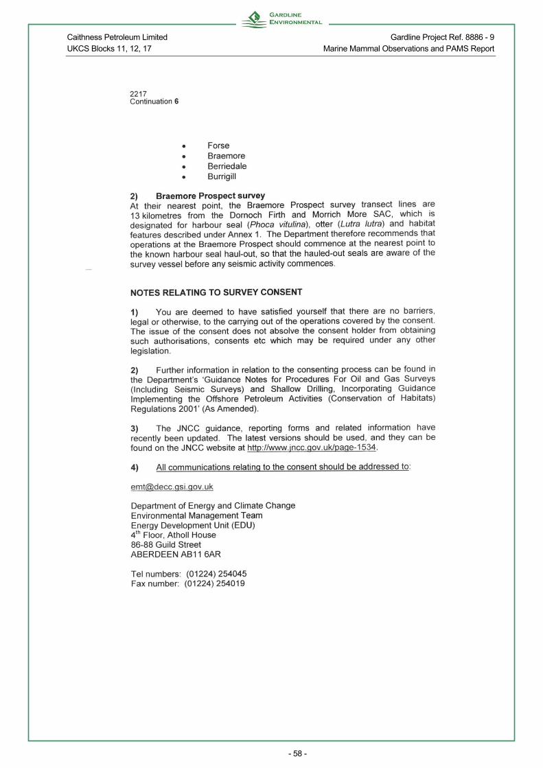
Caithness Petroleum Limited Gardline Project Ref. 8886 - 9 UKCS Blocks 11, 12, 17 Marine Mammal Observations and PAMS Report
- 58 -

Caithness Petroleum Limited Gardline Project Ref. 8886 - 9 UKCS Blocks 11, 12, 17 Marine Mammal Observations and PAMS Report
- 59 -

Caithness Petroleum Limited Gardline Project Ref. 8886 - 9 UKCS Blocks 11, 12, 17 Marine Mammal Observations and PAMS Report
- 60 -
APPENDIX C BEAUFORT WIND, SEA CONDITIONS AND VISIBILITY
WIND SPEED
Beaufort Scale Name Knots Metres/second
0 Calm 0 - 1 0 - 0.2 1 Light air 1 - 3 0.3 - 1.5 2 Light breeze 4 - 6 1.6 - 3.3 3 Gentle breeze 7 - 10 3.4 - 5.4 4 Moderate breeze 11 - 16 5.5 - 7.9 5 Fresh breeze 17 - 21 8.0 - 10.7 6 Strong breeze 22 - 27 10.8 - 13.8 7 Near gale 28 - 33 13.9 - 17.1 8 Gale 34 - 40 17.2 - 20.7 9 Strong gale 41 - 47 20.8 - 24.4 10 Storm 48 - 55 24.5 - 28.4 11 Violent storm 56 - 63 28.5 - 32.6 12 Hurricane 64+ 32.7+
SEA STATE
Symbol Name Height in metres
0 Calm (glassy) 0 1 Calm (rippled) 0 – 0.10 2 Smooth (wavelets) 0.10 – 0.50 3 Slight 0.50 – 1.25 4 Moderate 1.25 – 2.50 5 Rough 2.50 – 4.00 6 Very rough 4.00 – 6.00 7 High 6.00 – 9.00 8 Very high 9.00 – 14.00 9 Phenomenal 14.00+
VISIBILITY
Name Visibility (nautical miles)
Fog or dense snow fall Less than 0.5 Poor visibility 0.5 – 2.0
Moderate visibility 2.0 – 5.0 Good visibility 5.0 – 25.0
Very good visibility More than 25.0
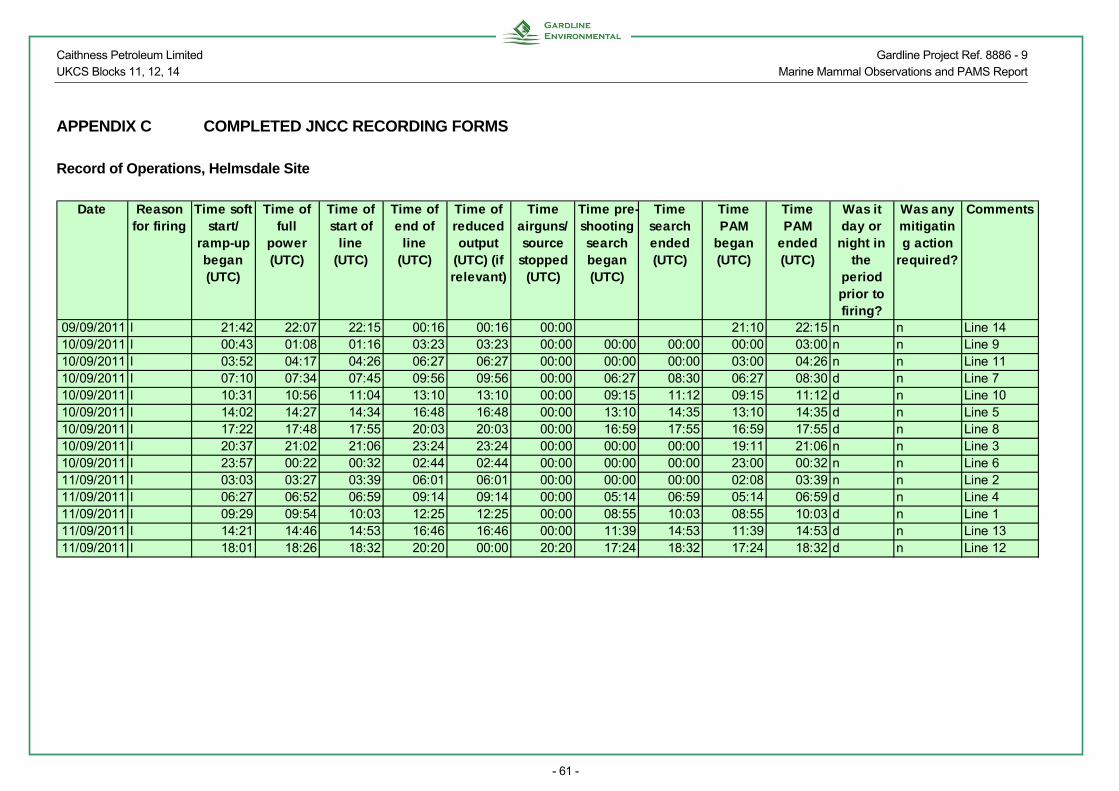
Caithness Petroleum Limited Gardline Project Ref. 8886 - 9 UKCS Blocks 11, 12, 14 Marine Mammal Observations and PAMS Report
- 61 -
APPENDIX C COMPLETED JNCC RECORDING FORMS
Record of Operations, Helmsdale Site
Date Reason
for firingTime soft
start/ ramp-up began (UTC)
Time of full
power (UTC)
Time of start of
line (UTC)
Time of end of
line (UTC)
Time of reduced output
(UTC) (if relevant)
Time airguns/ source
stopped (UTC)
Time pre-shooting search began (UTC)
Time search ended (UTC)
Time PAM
began (UTC)
Time PAM
ended (UTC)
Was it day or
night in the
period prior to firing?
Was any mitigating action
required?
Comments
09/09/2011 l 21:42 22:07 22:15 00:16 00:16 00:00 21:10 22:15 n n Line 1410/09/2011 l 00:43 01:08 01:16 03:23 03:23 00:00 00:00 00:00 00:00 03:00 n n Line 910/09/2011 l 03:52 04:17 04:26 06:27 06:27 00:00 00:00 00:00 03:00 04:26 n n Line 1110/09/2011 l 07:10 07:34 07:45 09:56 09:56 00:00 06:27 08:30 06:27 08:30 d n Line 710/09/2011 l 10:31 10:56 11:04 13:10 13:10 00:00 09:15 11:12 09:15 11:12 d n Line 1010/09/2011 l 14:02 14:27 14:34 16:48 16:48 00:00 13:10 14:35 13:10 14:35 d n Line 510/09/2011 l 17:22 17:48 17:55 20:03 20:03 00:00 16:59 17:55 16:59 17:55 d n Line 810/09/2011 l 20:37 21:02 21:06 23:24 23:24 00:00 00:00 00:00 19:11 21:06 n n Line 310/09/2011 l 23:57 00:22 00:32 02:44 02:44 00:00 00:00 00:00 23:00 00:32 n n Line 611/09/2011 l 03:03 03:27 03:39 06:01 06:01 00:00 00:00 00:00 02:08 03:39 n n Line 211/09/2011 l 06:27 06:52 06:59 09:14 09:14 00:00 05:14 06:59 05:14 06:59 d n Line 411/09/2011 l 09:29 09:54 10:03 12:25 12:25 00:00 08:55 10:03 08:55 10:03 d n Line 111/09/2011 l 14:21 14:46 14:53 16:46 16:46 00:00 11:39 14:53 11:39 14:53 d n Line 1311/09/2011 l 18:01 18:26 18:32 20:20 00:00 20:20 17:24 18:32 17:24 18:32 d n Line 12

Caithness Petroleum Limited Gardline Project Ref. 8886 - 9 UKCS Blocks 11, 12, 14 Marine Mammal Observations and PAMS Report
- 62 -
Effort Forms, Helmsdale Site
Date
Visu
al watch
or P
AM
?
Ob
server's / op
erator's
nam
e(s)
Tim
e of start o
f watch
(UT
C)
Tim
e of en
d o
f watch
(UT
C)
Start L
atitud
e (decim
al d
egrees)
Start p
ositio
n - n
orth
/ sou
th
Start L
on
gtitu
de (d
ecimal
deg
rees)
Start p
ositio
n - east/ w
est
Dep
th o
f water at start
po
stion
(m)
En
d L
atitud
e (decim
al d
egrees)
En
d p
ositio
n - n
orth
/ sou
th
En
d lo
ng
titud
e (decim
al d
egrees)
En
d p
ositio
n - east/ w
est
Dep
th o
f water at en
d
po
sition
(m)
Sp
eed o
f vessel (kno
ts)
So
urce activity
Win
d d
irection
Win
d fo
rce (Beau
fort)
Sea state
Sw
ell
Visib
ility (visual w
atch o
nly)
Su
ng
lare (visual w
atch o
nly)
09/09/2011 p N. Russell 21:10 21:42 58.02 n 3.33 w 56.0 58.02 n 3.36 w 50.0 4.3 n sw 2 s o09/09/2011 p N. Russell 21:42 22:15 58.02 n 3.36 w 50.0 58.03 n 3.44 w 46.0 4.2 s sw 2 s o10/09/2011 p K. Preston 00:00 00:16 58.05 n 3.66 w 28.0 58.06 n 3.70 w 27.6 4.2 f sw 1 s o10/09/2011 p K. Preston 00:16 00:43 58.06 n 3.70 w 27.6 58.04 n 3.74 w 22.0 4.3 r e 1 s o10/09/2011 p K. Preston 00:43 01:16 58.04 n 3.74 w 22.0 58.03 n 3.68 w 38.3 4.3 s e 2 s o10/09/2011 p K. Preston 01:16 03:00 58.03 n 3.68 w 38.3 58.01 n 3.46 w 51.6 4.3 f e 2 s o10/09/2011 p K. Preston 03:00 03:23 58.01 n 3.46 w 51.6 58.01 n 3.41 w 50.0 4.3 f e 2 s o10/09/2011 p K. Preston 03:23 03:52 58.01 n 3.41 w 50.0 58.02 n 3.37 w 45.5 4.3 r e 2 s o10/09/2011 p K. Preston 03:52 04:26 58.02 n 3.37 w 45.4 58.02 n 3.44 w 46.2 4.5 s e 2 s o10/09/2011 p K. Preston 04:26 04:53 58.02 n 3.44 w 46.2 58.48 n 3.48 w 44.3 4.2 f e 2 s o10/09/2011 p K. Preston 04:53 06:27 58.03 n 3.50 w 45.8 58.06 n 3.70 w 28.1 4.3 f e 2 s o10/09/2011 v Z. Allen, N. Duthie 05:15 06:27 58.03 n 3.54 w 36.9 58.06 n 3.70 w 28.1 4.3 f e 2 s o m n10/09/2011 v Z. Allen, N. Duthie 06:27 07:10 58.06 n 3.70 w 28.1 58.03 n 3.77 w 27.5 4.3 r e 3 s o m n10/09/2011 p K. Preston 06:27 07:10 58.06 n 3.70 w 28.1 58.03 n 3.77 w 27.5 4.3 r e 3 s o10/09/2011 v Z. Allen, N. Duthie 07:10 07:45 58.03 n 3.77 w 27.5 58.02 n 3.70 w 42.5 4.0 s e 3 s o m n10/09/2011 p K. Preston 07:10 07:45 58.03 n 3.77 w 27.5 58.02 n 3.70 w 42.5 4.0 s e 3 s o10/09/2011 v N. Duthie 07:45 08:30 58.02 n 3.70 w 42.5 58.01 n 3.59 w 44.1 4.1 f e 3 s o m n10/09/2011 p K. Preston 07:45 08:30 58.02 n 3.70 w 42.5 58.01 n 3.59 w 44.1 4.1 f e 3 s o10/09/2011 v N. Duthie 08:30 08:55 58.01 n 3.59 w 44.1 58 n 3.55 w 50.3 4.1 f e 4 s o m n10/09/2011 p K. Preston 08:30 08:55 58.01 n 3.59 w 44.1 58 n 3.55 w 50.3 4.1 f e 4 s o10/09/2011 v K. Preston 08:55 09:15 58.00 n 3.55 w 50.3 58 n 3.51 w 51.9 4.1 f e 4 s o m n
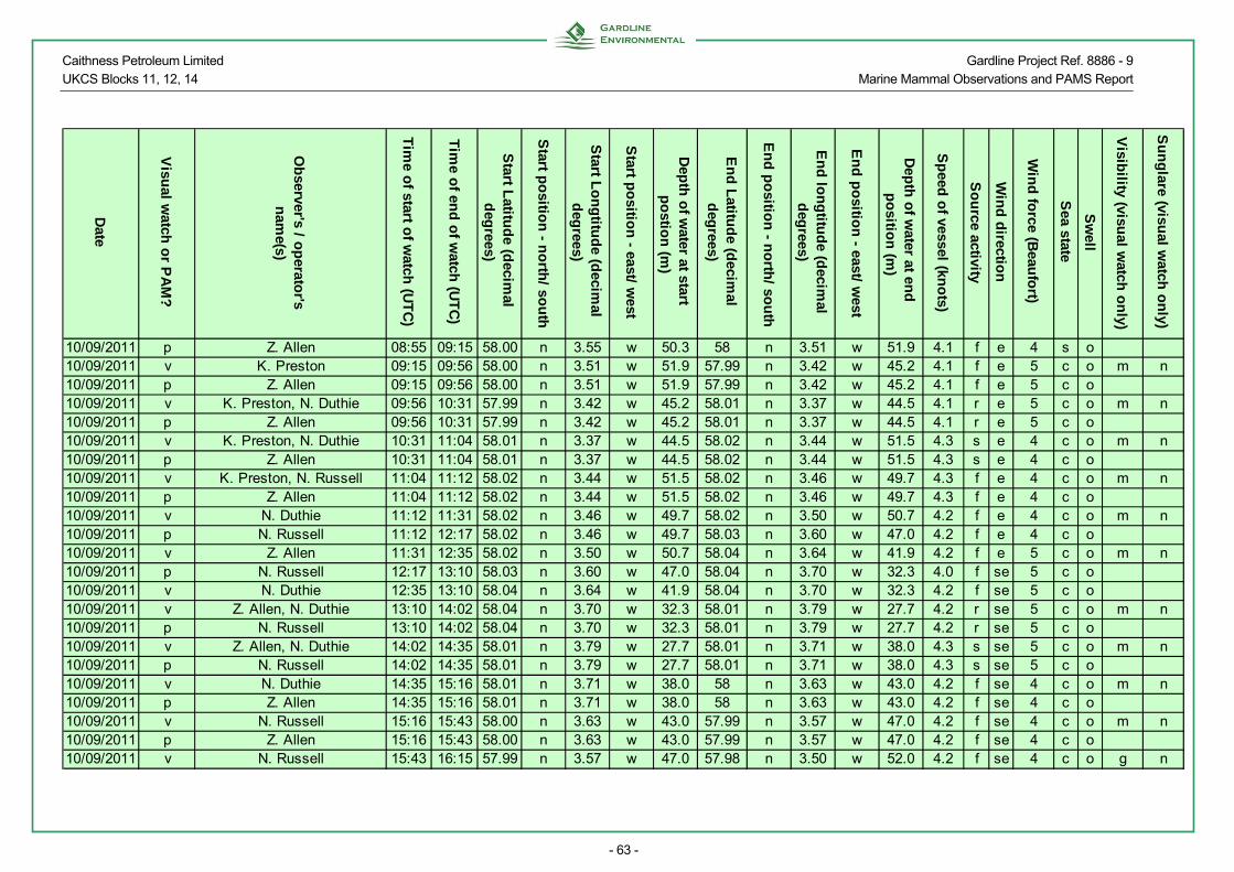
Caithness Petroleum Limited Gardline Project Ref. 8886 - 9 UKCS Blocks 11, 12, 14 Marine Mammal Observations and PAMS Report
- 63 -
Date
Visu
al watch
or P
AM
?
Ob
server's / op
erator's
nam
e(s)
Tim
e of start o
f watch
(UT
C)
Tim
e of en
d o
f watch
(UT
C)
Start L
atitud
e (decim
al d
egrees)
Start p
ositio
n - n
orth
/ sou
th
Start L
on
gtitu
de (d
ecimal
deg
rees)
Start p
ositio
n - east/ w
est
Dep
th o
f water at start
po
stion
(m)
En
d L
atitud
e (decim
al d
egrees)
En
d p
ositio
n - n
orth
/ sou
th
En
d lo
ng
titud
e (decim
al d
egrees)
En
d p
ositio
n - east/ w
est
Dep
th o
f water at en
d
po
sition
(m)
Sp
eed o
f vessel (kno
ts)
So
urce activity
Win
d d
irection
Win
d fo
rce (Beau
fort)
Sea state
Sw
ell
Visib
ility (visual w
atch o
nly)
Su
ng
lare (visual w
atch o
nly)
10/09/2011 p Z. Allen 08:55 09:15 58.00 n 3.55 w 50.3 58 n 3.51 w 51.9 4.1 f e 4 s o10/09/2011 v K. Preston 09:15 09:56 58.00 n 3.51 w 51.9 57.99 n 3.42 w 45.2 4.1 f e 5 c o m n10/09/2011 p Z. Allen 09:15 09:56 58.00 n 3.51 w 51.9 57.99 n 3.42 w 45.2 4.1 f e 5 c o10/09/2011 v K. Preston, N. Duthie 09:56 10:31 57.99 n 3.42 w 45.2 58.01 n 3.37 w 44.5 4.1 r e 5 c o m n10/09/2011 p Z. Allen 09:56 10:31 57.99 n 3.42 w 45.2 58.01 n 3.37 w 44.5 4.1 r e 5 c o10/09/2011 v K. Preston, N. Duthie 10:31 11:04 58.01 n 3.37 w 44.5 58.02 n 3.44 w 51.5 4.3 s e 4 c o m n10/09/2011 p Z. Allen 10:31 11:04 58.01 n 3.37 w 44.5 58.02 n 3.44 w 51.5 4.3 s e 4 c o10/09/2011 v K. Preston, N. Russell 11:04 11:12 58.02 n 3.44 w 51.5 58.02 n 3.46 w 49.7 4.3 f e 4 c o m n10/09/2011 p Z. Allen 11:04 11:12 58.02 n 3.44 w 51.5 58.02 n 3.46 w 49.7 4.3 f e 4 c o10/09/2011 v N. Duthie 11:12 11:31 58.02 n 3.46 w 49.7 58.02 n 3.50 w 50.7 4.2 f e 4 c o m n10/09/2011 p N. Russell 11:12 12:17 58.02 n 3.46 w 49.7 58.03 n 3.60 w 47.0 4.2 f e 4 c o10/09/2011 v Z. Allen 11:31 12:35 58.02 n 3.50 w 50.7 58.04 n 3.64 w 41.9 4.2 f e 5 c o m n10/09/2011 p N. Russell 12:17 13:10 58.03 n 3.60 w 47.0 58.04 n 3.70 w 32.3 4.0 f se 5 c o10/09/2011 v N. Duthie 12:35 13:10 58.04 n 3.64 w 41.9 58.04 n 3.70 w 32.3 4.2 f se 5 c o10/09/2011 v Z. Allen, N. Duthie 13:10 14:02 58.04 n 3.70 w 32.3 58.01 n 3.79 w 27.7 4.2 r se 5 c o m n10/09/2011 p N. Russell 13:10 14:02 58.04 n 3.70 w 32.3 58.01 n 3.79 w 27.7 4.2 r se 5 c o10/09/2011 v Z. Allen, N. Duthie 14:02 14:35 58.01 n 3.79 w 27.7 58.01 n 3.71 w 38.0 4.3 s se 5 c o m n10/09/2011 p N. Russell 14:02 14:35 58.01 n 3.79 w 27.7 58.01 n 3.71 w 38.0 4.3 s se 5 c o10/09/2011 v N. Duthie 14:35 15:16 58.01 n 3.71 w 38.0 58 n 3.63 w 43.0 4.2 f se 4 c o m n10/09/2011 p Z. Allen 14:35 15:16 58.01 n 3.71 w 38.0 58 n 3.63 w 43.0 4.2 f se 4 c o10/09/2011 v N. Russell 15:16 15:43 58.00 n 3.63 w 43.0 57.99 n 3.57 w 47.0 4.2 f se 4 c o m n10/09/2011 p Z. Allen 15:16 15:43 58.00 n 3.63 w 43.0 57.99 n 3.57 w 47.0 4.2 f se 4 c o10/09/2011 v N. Russell 15:43 16:15 57.99 n 3.57 w 47.0 57.98 n 3.50 w 52.0 4.2 f se 4 c o g n

Caithness Petroleum Limited Gardline Project Ref. 8886 - 9 UKCS Blocks 11, 12, 14 Marine Mammal Observations and PAMS Report
- 64 -
Date
Visu
al watch
or P
AM
?
Ob
server's / op
erator's
nam
e(s)
Tim
e of start o
f watch
(UT
C)
Tim
e of en
d o
f watch
(UT
C)
Start L
atitud
e (decim
al d
egrees)
Start p
ositio
n - n
orth
/ sou
th
Start L
on
gtitu
de (d
ecimal
deg
rees)
Start p
ositio
n - east/ w
est
Dep
th o
f water at start
po
stion
(m)
En
d L
atitud
e (decim
al d
egrees)
En
d p
ositio
n - n
orth
/ sou
th
En
d lo
ng
titud
e (decim
al d
egrees)
En
d p
ositio
n - east/ w
est
Dep
th o
f water at en
d
po
sition
(m)
Sp
eed o
f vessel (kno
ts)
So
urce activity
Win
d d
irection
Win
d fo
rce (Beau
fort)
Sea state
Sw
ell
Visib
ility (visual w
atch o
nly)
Su
ng
lare (visual w
atch o
nly)
10/09/2011 p N. Duthie 15:43 16:41 57.99 n 3.57 w 47.0 57.98 n 3.45 w 48.9 4.2 f se 4 c o10/09/2011 v Z. Allen 16:15 16:49 57.98 n 3.50 w 52.0 57.97 n 3.43 w 49.0 4.2 f se 5 c o g n10/09/2011 p N. Russell 16:41 16:49 57.98 n 3.45 w 48.9 57.97 n 3.43 w 49.0 4.2 f se 5 c o10/09/2011 v Z. Allen 16:49 17:08 57.97 n 3.43 w 45.9 57.98 n 3.39 w 44.0 4.5 r se 5 c o g w10/09/2011 p N. Russell 16:49 17:23 57.97 n 3.43 w 45.9 57.89 n 3.38 w 41.4 4.5 r se 5 c o10/09/2011 v Z. Allen, N. Duthie 17:08 17:23 57.98 n 3.39 w 44.0 57.89 n 3.38 w 41.4 4.4 r se 5 c o g v10/09/2011 v Z. Allen, N. Duthie 17:23 17:55 57.89 n 3.38 w 41.4 58 n 3.46 w 48.9 4.2 s se 4 c o g v10/09/2011 p N. Russell 17:23 17:55 57.89 n 3.38 w 41.4 58 n 3.46 w 48.9 4.2 s se 4 c o10/09/2011 v Z. Allen 17:55 18:50 58.00 n 3.46 w 48.9 58.01 n 3.57 w 43.0 4.3 f se 3 s o g w10/09/2011 p N. Russell 17:55 18:50 58.00 n 3.46 w 48.9 58.01 n 3.57 w 43.0 4.3 f se 3 s o10/09/2011 v Z. Allen 18:50 19:05 58.01 n 3.57 w 43.0 58.02 n 3.60 w 44.2 4.3 f s 4 s o g n10/09/2011 p N. Duthie 18:50 19:11 58.01 n 3.57 w 43.0 58.02 n 3.62 w 37.0 4.3 f s 4 s o10/09/2011 p N. Russell 19:11 20:03 58.02 n 3.62 w 37.0 58.03 n 3.73 w 34.2 4.2 f s 4 c o10/09/2011 p N. Russell 20:03 20:37 58.03 n 3.73 w 34.2 58.01 n 3.77 w 30.6 4.2 r se 4 c o10/09/2011 p N. Russell 20:37 21:06 58.01 n 3.77 w 30.6 57.99 n 3.71 w 42.0 4.2 s se 5 c o10/09/2011 p N. Russell 21:06 22:04 57.99 n 3.71 w 42.0 57.98 n 3.61 w 46.0 4.1 f se 4 c o10/09/2011 p N. Russell 22:04 23:00 57.98 n 3.61 w 46.0 57.97 n 3.51 w 47.0 4.2 f se 5 c o10/09/2011 p K. Preston 23:00 23:24 57.97 n 3.51 w 47.0 57.96 n 3.41 w 46.5 4.2 f se 5 c o10/09/2011 p K. Preston 23:24 23:57 57.96 n 3.41 w 46.5 57.98 n 3.39 w 49.0 4.3 r se 4 s o10/09/2011 p K. Preston 23:57 23:59 57.98 n 3.39 w 49.0 57.98 n 3.40 w 48.9 4.3 s s 4 s o11/09/2011 p K. Preston 00:00 00:32 57.98 n 3.40 w 48.9 57.99 n 3.47 w 50.3 4.3 s s 4 s o11/09/2011 p K. Preston 00:32 02:08 57.99 n 3.47 w 50.3 58.01 n 3.67 w 43.0 4.2 f s 4 s o11/09/2011 p K. Preston 02:08 02:44 58.01 n 3.67 w 43.0 58.02 n 3.75 w 33.2 4.2 f w 4 s o11/09/2011 p K. Preston 02:44 03:03 58.02 n 3.75 w 33.2 58 n 3.78 w 27.6 4.2 r w 4 s o

Caithness Petroleum Limited Gardline Project Ref. 8886 - 9 UKCS Blocks 11, 12, 14 Marine Mammal Observations and PAMS Report
- 65 -
Date
Visu
al watch
or P
AM
?
Ob
server's / op
erator's
nam
e(s)
Tim
e of start o
f watch
(UT
C)
Tim
e of en
d o
f watch
(UT
C)
Start L
atitud
e (decim
al d
egrees)
Start p
ositio
n - n
orth
/ sou
th
Start L
on
gtitu
de (d
ecimal
deg
rees)
Start p
ositio
n - east/ w
est
Dep
th o
f water at start
po
stion
(m)
En
d L
atitud
e (decim
al d
egrees)
En
d p
ositio
n - n
orth
/ sou
th
En
d lo
ng
titud
e (decim
al d
egrees)
En
d p
ositio
n - east/ w
est
Dep
th o
f water at en
d
po
sition
(m)
Sp
eed o
f vessel (kno
ts)
So
urce activity
Win
d d
irection
Win
d fo
rce (Beau
fort)
Sea state
Sw
ell
Visib
ility (visual w
atch o
nly)
Su
ng
lare (visual w
atch o
nly)
11/09/2011 p K. Preston 03:03 03:39 58.00 n 3.78 w 27.6 57.98 n 3.74 w 39.0 4.2 s w 4 s o11/09/2011 p K. Preston 03:39 05:14 57.98 n 3.74 w 39.0 57.96 n 3.54 w 50.1 4.2 f w 4 s o11/09/2011 v Z. Allen, N. Duthie 05:14 06:01 57.96 n 3.54 w 50.1 57.95 n 3.44 w 44.0 4.2 f se 4 s o m n11/09/2011 p K. Preston 05:14 06:01 57.96 n 3.54 w 50.1 57.95 n 3.44 w 44.0 4.2 f se 4 s o11/09/2011 v Z. Allen, N. Duthie 06:01 06:27 57.95 n 3.44 w 44.0 57.96 n 3.40 w 46.2 4.2 r se 4 s o m v11/09/2011 p K. Preston 06:01 06:27 57.95 n 3.44 w 44.0 57.96 n 3.40 w 46.2 4.2 r se 4 s o11/09/2011 v Z. Allen, N. Duthie 06:27 06:59 57.96 n 3.40 w 46.2 57.97 n 3.47 w 50.2 4.5 s se 3 s o m v11/09/2011 p K. Preston 06:27 06:59 57.96 n 3.40 w 46.2 57.97 n 3.47 w 50.2 4.5 s se 3 s o11/09/2011 v Z. Allen, N. Duthie 06:59 07:15 57.97 n 3.47 w 50.2 57.97 n 3.51 w 51.9 4.3 f s 4 s o g v11/09/2011 p K. Preston 06:59 07:15 57.97 n 3.47 w 50.2 57.97 n 3.51 w 51.9 4.3 f s 4 s o11/09/2011 v K. Preston 07:15 08:20 57.97 n 3.51 w 51.9 57.99 n 3.65 w 44.1 4.3 f s 4 s o g v11/09/2011 p Z. Allen 07:15 08:20 57.97 n 3.51 w 51.9 57.99 n 3.65 w 44.1 4.3 f s 4 s o11/09/2011 v N. Duthie 08:20 08:55 57.99 n 3.65 w 44.1 58 n 3.72 w 38.0 4.3 f s 4 s o g v11/09/2011 p K. Preston 08:20 08:55 57.99 n 3.65 w 44.1 58 n 3.72 w 38.0 4.3 f s 4 s o11/09/2011 v N. Duthie, Z. Allen 08:55 09:14 58.00 n 3.72 w 38.0 58 n 3.76 w 30.1 4.3 f s 4 c o g v11/09/2011 p K. Preston 08:55 09:14 58.00 n 3.72 w 38.0 58 n 3.76 w 30.1 4.3 f s 4 c o11/09/2011 v N. Duthie, Z. Allen 09:14 09:29 58.00 n 3.76 w 30.1 57.99 n 3.79 w 27.9 4.3 r s 4 c o g v11/09/2011 p K. Preston 09:14 09:29 58.00 n 3.76 w 30.1 57.99 n 3.79 w 27.9 4.3 r s 4 c o11/09/2011 v N. Duthie, Z. Allen 09:29 10:03 57.99 n 3.79 w 27.9 57.98 n 3.75 w 39.2 4.3 s s 4 c o g v11/09/2011 p K. Preston 09:29 10:03 57.99 n 3.79 w 27.9 57.98 n 3.75 w 39.2 4.3 s s 4 c o11/09/2011 v N. Duthie, Z. Allen 10:03 10:13 57.98 n 3.75 w 39.2 57.97 n 3.73 w 43.5 4.1 f s 4 c o g n11/09/2011 p K. Preston 10:03 10:13 57.98 n 3.75 w 39.2 57.97 n 3.73 w 43.5 4.1 f s 4 c o11/09/2011 v N. Duthie 10:13 10:56 57.97 n 3.73 w 43.5 58.96 n 3.64 w 42.0 4.1 f s 4 c o g n11/09/2011 p K. Preston 10:13 10:56 57.97 n 3.73 w 43.5 58.96 n 3.64 w 42.0 4.1 f s 4 c o

Caithness Petroleum Limited Gardline Project Ref. 8886 - 9 UKCS Blocks 11, 12, 14 Marine Mammal Observations and PAMS Report
- 66 -
Date
Visu
al watch
or P
AM
?
Ob
server's / op
erator's
nam
e(s)
Tim
e of start o
f watch
(UT
C)
Tim
e of en
d o
f watch
(UT
C)
Start L
atitud
e (decim
al d
egrees)
Start p
ositio
n - n
orth
/ sou
th
Start L
on
gtitu
de (d
ecimal
deg
rees)
Start p
ositio
n - east/ w
est
Dep
th o
f water at start
po
stion
(m)
En
d L
atitud
e (decim
al d
egrees)
En
d p
ositio
n - n
orth
/ sou
th
En
d lo
ng
titud
e (decim
al d
egrees)
En
d p
ositio
n - east/ w
est
Dep
th o
f water at en
d
po
sition
(m)
Sp
eed o
f vessel (kno
ts)
So
urce activity
Win
d d
irection
Win
d fo
rce (Beau
fort)
Sea state
Sw
ell
Visib
ility (visual w
atch o
nly)
Su
ng
lare (visual w
atch o
nly)
11/09/2011 v N. Russell 10:56 11:39 58.96 n 3.64 w 42.0 57.95 n 3.54 w 54.0 4.2 f s 4 c o g v11/09/2011 p Z. Allen 10:56 11:39 58.96 n 3.64 w 42.0 57.95 n 3.54 w 54.0 4.2 f s 4 c o11/09/2011 v N. Russell 11:39 12:26 57.95 n 3.54 w 54.0 57.94 n 3.44 w 47.8 4.2 f s 4 c o g v11/09/2011 p Z. Allen 11:39 12:26 57.95 n 3.54 w 54.0 57.94 n 3.44 w 47.8 4.2 f s 5 c o11/09/2011 v N. Russell, N. Duthie 12:26 13:29 57.94 n 3.44 w 47.8 57.93 n 3.53 w 58.0 4.2 r s 5 c o g v11/09/2011 p Z. Allen 12:26 13:29 57.94 n 3.44 w 47.8 57.93 n 3.53 w 58.0 4.2 r s 5 c o11/09/2011 v N. Russell, N. Duthie 13:29 14:21 57.93 n 3.53 w 58.0 57.91 n 3.57 w 59.1 4.3 r s 4 c o g v11/09/2011 p Z. Allen 13:29 14:21 57.93 n 3.53 w 58.0 57.91 n 3.57 w 59.1 4.3 r s 4 c o11/09/2011 v N. Russell, N. Duthie 14:21 14:53 57.91 n 3.57 w 59.1 57.94 n 3.54 w 55.6 4.2 s s 3 s o g v11/09/2011 p Z. Allen 14:21 14:53 57.91 n 3.57 w 59.1 57.94 n 3.54 w 55.6 4.2 s s 3 s o11/09/2011 v N. Russell 14:53 15:09 57.94 n 3.54 w 55.6 57.96 n 3.53 w 54.0 4.2 f s 3 s o g v11/09/2011 p Z. Allen 14:53 15:09 57.94 n 3.54 w 55.6 57.96 n 3.53 w 54.0 4.2 f s 3 s o11/09/2011 v N. Russell 15:09 15:52 57.96 n 3.53 w 54.0 58 n 3.50 w 52.0 4.2 f s 3 s o m n11/09/2011 p N. Duthie 15:09 15:52 57.96 n 3.53 w 54.0 58 n 3.50 w 52.0 4.2 f s 3 s o11/09/2011 v N. Russell 15:52 16:27 58.00 n 3.50 w 52.0 58.04 n 3.46 w 40.0 4.2 f s 3 s o m n11/09/2011 p Z. Allen 15:52 16:27 58.00 n 3.50 w 52.0 58.04 n 3.46 w 40.0 4.2 f s 3 s o11/09/2011 v N. Russell 16:27 16:48 58.04 n 3.46 w 40.0 58.06 n 3.44 w 48.0 4.2 f s 3 s o g n11/09/2011 p N. Duthie 16:27 16:48 58.04 n 3.46 w 40.0 58.06 n 3.44 w 48.0 4.2 f s 3 s o11/09/2011 v Z. Allen 16:48 17:06 58.06 n 3.44 w 48.0 58.08 n 3.47 w 42.0 4.6 r s 3 s o g n11/09/2011 p N. Russell 16:48 17:06 58.06 n 3.44 w 48.0 58.08 n 3.47 w 42.0 4.6 r s 3 s o11/09/2011 v Z. Allen, N. Russell 17:06 18:01 58.08 n 3.47 w 42.0 58.02 n 3.63 w 44.0 4.2 s s 3 s o g n11/09/2011 p N. Duthie 17:06 18:01 58.08 n 3.47 w 42.0 58.02 n 3.63 w 44.0 4.2 s s 3 s o11/09/2011 v Z. Allen, N. Russell 18:01 19:04 58.02 n 3.63 w 44.0 58.01 n 3.64 w 43.0 4.2 f s 3 s o11/09/2011 p N. Duthie 18:01 19:04 58.02 n 3.63 w 44.0 58.01 n 3.64 w 43.0 4.2 f s 3 s o g n

Caithness Petroleum Limited Gardline Project Ref. 8886 - 9 UKCS Blocks 11, 12, 14 Marine Mammal Observations and PAMS Report
- 67 -
Date
Visu
al watch
or P
AM
?
Ob
server's / op
erator's
nam
e(s)
Tim
e of start o
f watch
(UT
C)
Tim
e of en
d o
f watch
(UT
C)
Start L
atitud
e (decim
al d
egrees)
Start p
ositio
n - n
orth
/ sou
th
Start L
on
gtitu
de (d
ecimal
deg
rees)
Start p
ositio
n - east/ w
est
Dep
th o
f water at start
po
stion
(m)
En
d L
atitud
e (decim
al d
egrees)
En
d p
ositio
n - n
orth
/ sou
th
En
d lo
ng
titud
e (decim
al d
egrees)
En
d p
ositio
n - east/ w
est
Dep
th o
f water at en
d
po
sition
(m)
Sp
eed o
f vessel (kno
ts)
So
urce activity
Win
d d
irection
Win
d fo
rce (Beau
fort)
Sea state
Sw
ell
Visib
ility (visual w
atch o
nly)
Su
ng
lare (visual w
atch o
nly)
11/09/2011 p N. Russell 19:04 20:07 58.01 n 3.64 w 43.0 57.95 n 3.67 w 42.0 4.2 f s 3 s o11/09/2011 p N. Russell 20:07 20:20 57.95 n 3.67 w 42.0 58.94 n 3.68 w 43.0 4.3 f s 3 s o

Caithness Petroleum Limited Gardline Project Ref. 8886 - 9 UKCS Blocks 11, 12, 14 Marine Mammal Observations and PAMS Report
- 68 -
Sightings, Helmsdale Site
Sig
htin
g n
um
ber
Date
Tim
e at start of en
cou
nter (U
TC
)
Tim
e at end
of en
cou
nter (U
TC
)
Were an
imals d
etected visu
ally and
/ or aco
ustically?
Ho
w w
ere the an
imals first d
etected?
Ob
server's/ op
erator's n
ame
Po
sition
- decim
al deg
rees latitud
e
Po
sition
- no
rth/ so
uth
Po
sition
- decim
al deg
rees lon
gitu
de
Po
sition
- east/ west
Water d
epth
(metres)
Sp
ecies or sp
ecies gro
up
Descrip
tion
(visual sig
htin
g o
nly)
Bearin
g to
anim
al
Ran
ge o
f anim
al (metres)
To
tal nu
mb
er
Nu
mb
er of ad
ults (visu
al sigh
ting
s on
ly)
Nu
mb
er of calves (visu
al sigh
ting
s on
ly)
Beh
aviou
r (visual sig
htin
gs o
nly)
Directio
n o
f travel (relative to sh
ip)
Directio
n o
f travel (com
pass p
oin
ts)
Airg
un
/ sou
rce activity wh
en an
imals first d
etected
Airg
un
/ sou
rce activity wh
en an
imals last d
etected
Clo
sest distan
ce of an
imals fro
m airg
un
s/ sou
rce (m)
Tim
e of clo
sest app
roach
(UT
C)
First o
bserved
distan
ce du
ring
soft start (if relevan
t) (m)
Clo
sest ob
served d
istance d
urin
g so
ft start (if relevant) (m
)
Last o
bserved
distan
ce du
ring
soft start (if relevan
t) (m)
Wh
at action
was taken
?
1 11/09/2011 0.8 0.8 v v Z. Allen 58.09 n 3.60 w 25Northern Minke Whale
Dark body, tall, falcate fin, arched back during roll 150 800 1 1 0 Travelling v ne s s 800 0.8 800 800 2500 n
2 12/09/2011 0.5 0.5 v i K. Preston 57.61 n 4.07 w 20Bottlenose Dolphin
Grey body, large dolphins, falcate dorsal fin 290 500 12 0 0
Breaching, leaping, bow riding, travelling t se n n 70 0.5 0 0 0 n

Caithness Petroleum Limited Gardline Project Ref. 8886 - 9 UKCS Blocks 11, 12, 14 Marine Mammal Observations and PAMS Report
- 69 -
Record of Operations, Forse Site Date Reason
for firingTime soft
start/ ramp-up began (UTC)
Time of full
power (UTC)
Time of start of
line (UTC)
Time of end of
line (UTC)
Time of reduced output
(UTC) (if relevant)
Time airguns/ source
stopped (UTC)
Time pre-shooting search began (UTC)
Time search ended (UTC)
Time PAM
began (UTC)
Time PAM
ended (UTC)
Was it day or
night in the
period prior to firing?
Was any mitigating action
required?
Comments
14/09/2011 t 01:19 01:45 01:45 02:04 02:04 00:00 00:00 00:00 00:47 00:00 n n Gun test14/09/2011 l 04:07 04:32 04:40 06:18 06:18 00:00 00:00 00:00 03:12 04:40 n n Line 114/09/2011 l 08:17 08:42 08:48 10:26 00:00 10:26 00:00 00:00 07:24 08:48 d n Line 214/09/2011 l 17:07 17:32 17:40 19:17 19:17 00:00 16:35 17:40 16:35 17:40 d n Line 3
14/09/2011 l 21:27 21:52 21:54 23:25 00:00 23:25 00:00 00:00 20:20 21:56 n n
Line 4 guns stopped for maintenance
15/09/2011 t 00:13 00:00 00:00 00:00 00:00 00:50 00:00 00:00 21:56 00:17 n n
Intermittent gun testing, problems with software
15/09/2011 l 01:21 01:46 01:53 03:22 03:22 00:00 00:00 00:00 00:48 01:53 n n Line 515/09/2011 l 05:18 05:43 05:49 07:15 07:15 00:00 00:00 00:00 04:30 05:49 n n Line 615/09/2011 l 09:11 09:36 09:43 11:05 11:05 00:00 06:56 09:43 06:56 09:43 d n Line 715/09/2011 l 11:45 12:10 12:14 12:32 12:32 00:00 11:05 12:14 11:05 12:14 d n Line 1615/09/2011 l 13:16 13:41 13:48 14:09 14:09 00:00 12:14 13:48 12:14 13:48 d n Line 1715/09/2011 l 14:56 15:21 15:25 15:50 15:50 00:00 14:09 15:25 14:09 15:25 d n Line 1815/09/2011 l 16:33 16:58 17:04 17:28 17:28 00:00 15:53 17:04 15:53 17:04 d n Line 19
15/09/2011 l 18:51 00:00 00:00 00:00 00:00 19:08 17:28 18:51 17:28 19:35 k nSoft start aborted
15/09/2011 l 19:08 19:29 19:32 21:02 21:02 00:00 00:00 00:00 17:28 19:35 n n Line 8

Caithness Petroleum Limited Gardline Project Ref. 8886 - 9 UKCS Blocks 11, 12, 14 Marine Mammal Observations and PAMS Report
- 70 -
Date Reason for firing
Time soft start/
ramp-up began (UTC)
Time of full
power (UTC)
Time of start of
line (UTC)
Time of end of
line (UTC)
Time of reduced output
(UTC) (if relevant)
Time airguns/ source
stopped (UTC)
Time pre-shooting search began (UTC)
Time search ended (UTC)
Time PAM
began (UTC)
Time PAM
ended (UTC)
Was it day or
night in the
period prior to firing?
Was any mitigating action
required?
Comments
15/09/2011 l 22:35 22:57 23:02 00:19 00:19 00:37 00:00 00:00 22:01 23:04 n n
Line 9; went down on weather during line turn
18/09/2011 l 12:40 13:01 13:09 13:34 13:34 00:00 11:17 13:11 11:17 13:11 d n Line 2018/09/2011 l 14:30 14:51 14:59 15:27 15:27 00:00 13:34 14:59 13:34 14:59 d n Line 2118/09/2011 l 16:16 16:37 16:45 17:14 17:14 00:00 15:50 16:45 15:50 16:45 d n Line 2218/09/2011 l 18:04 18:25 18:34 19:05 19:05 00:00 17:15 18:35 17:15 18:35 d n Line 2318/09/2011 l 20:14 20:35 20:42 21:56 21:56 00:00 00:00 00:00 19:05 20:43 n n Line 1018/09/2011 l 23:40 00:01 00:07 01:18 01:18 00:00 00:00 00:00 22:48 00:07 n n Line 1119/09/2011 l 02:53 03:14 03:21 04:28 04:28 00:00 00:00 00:00 01:18 03:21 n n Line 1219/09/2011 l 07:07 07:28 07:39 08:09 08:09 00:00 06:00 07:39 05:25 07:39 d n Line 2419/09/2011 l 09:04 09:26 09:32 10:04 10:04 00:00 08:09 09:32 08:09 09:32 d n Line 2519/09/2011 l 10:57 11:19 11:26 11:56 11:56 00:00 10:04 11:26 10:04 11:26 d n Line 26
19/09/2011 l 12:53 13:14 13:24 13:53 00:00 13:53 11:56 13:24 11:56 13:24 d nLine 27; change to 8888
20/09/2011 l 03:35 03:56 04:09 05:07 00:00 05:07 00:00 00:00 02:44 04:09 n nLine 13a; back to 8888
22/09/2011 l 15:19 15:40 15:56 16:39 00:00 16:39 14:23 15:56 14:23 15:56 d n Line 15

Caithness Petroleum Limited Gardline Project Ref. 8886 - 9 UKCS Blocks 11, 12, 14 Marine Mammal Observations and PAMS Report
- 71 -
Effort Forms, Forse Site
Date
Visu
al watch
or P
AM
?
Ob
server's / op
erator's
nam
e(s)
Tim
e of start o
f watch
(UT
C)
Tim
e of en
d o
f watch
(UT
C)
Start L
atitud
e (decim
al d
egrees)
Start p
ositio
n - n
orth
/ sou
th
Start L
on
gtitu
de (d
ecimal
deg
rees)
Start p
ositio
n - east/ w
est
Dep
th o
f water at start
po
stion
(m)
En
d L
atitud
e (decim
al d
egrees)
En
d p
ositio
n - n
orth
/ sou
th
En
d lo
ng
titud
e (decim
al d
egrees)
En
d p
ositio
n - east/ w
est
Dep
th o
f water at en
d
po
sition
(m)
Sp
eed o
f vessel (kno
ts)
So
urce activity
Win
d d
irection
Win
d fo
rce (Beau
fort)
Sea state
Sw
ell
Visib
ility (visual w
atch o
nly)
Su
ng
lare (visual w
atch o
nly)
14/09/2011 p K. Preston 00:00 00:47 58.23 n 3.29 w 42.3 58.25 n 3.26 w 44.0 4.3 n nw 5 c o14/09/2011 p K. Preston 00:47 01:19 58.25 n 3.26 w 44.0 58.22 n 3.31 w 43.2 4.2 n nw 5 c o14/09/2011 p K. Preston 01:19 01:45 58.22 n 3.31 w 43.2 58.2 n 3.36 w 45.4 4.2 s nw 5 c o14/09/2011 p K. Preston 01:45 02:04 58.20 n 3.36 w 45.4 58.18 n 3.40 w 47.4 4.2 f nw 5 c o14/09/2011 p K. Preston 02:04 02:50 58.18 n 3.40 w 47.4 58.2 n 3.32 w 45.0 4.2 r nw 5 c o14/09/2011 p K. Preston 03:12 04:07 58.23 n 3.29 w 46.0 58.33 n 3.23 w 37.0 4.2 r nw 5 c o14/09/2011 p K. Preston 04:07 04:40 58.33 n 3.23 w 37.0 58.27 n 3.28 w 32.0 4.2 s sw 5 c o14/09/2011 p K. Preston 04:40 05:14 58.27 n 3.28 w 32.0 58.25 n 3.35 w 28.9 4.2 f sw 5 c o14/09/2011 v Z. Allen, N. Duthie 05:14 06:18 58.25 n 3.35 w 28.9 58.2 n 3.46 w 23.8 4.2 f sw 5 s o m n14/09/2011 p K. Preston 05:14 06:18 58.25 n 3.35 w 28.9 58.2 n 3.46 w 23.8 4.2 f sw 5 s o14/09/2011 v Z. Allen 06:18 07:24 58.20 n 3.46 w 23.8 58.24 n 3.33 w 38.0 4.9 r sw 5 c o g v14/09/2011 p K. Preston 06:18 07:24 58.20 n 3.46 w 23.8 58.24 n 3.33 w 38.0 4.9 r sw 5 c o14/09/2011 v Z. Allen, N. Duthie 07:24 08:17 58.24 n 3.33 w 38.0 58.28 n 3.23 w 35.3 4.6 r sw 6 c o g v14/09/2011 p K. Preston 07:24 08:17 58.24 n 3.33 w 38.0 58.28 n 3.23 w 35.3 4.6 r sw 6 c o14/09/2011 v Z. Allen, N. Duthie 08:17 08:34 58.28 n 3.23 w 35.3 58.29 n 3.26 w 32.2 4.0 s s 6 c o g v14/09/2011 p K. Preston 08:17 08:34 58.28 n 3.23 w 35.3 58.29 n 3.26 w 32.2 4.0 s s 6 c o14/09/2011 v Z. Allen, N. Duthie 08:34 08:48 58.29 n 3.26 w 32.2 58.27 n 3.29 w 30.8 4.0 s s 7 r o g v14/09/2011 p K. Preston 08:34 08:48 58.29 n 3.26 w 32.2 58.27 n 3.29 w 30.8 4.0 s s 7 r o14/09/2011 v N. Duthie 08:48 09:29 58.27 n 3.29 w 30.8 58.24 n 3.36 w 28.9 4.1 f s 7 r o g v14/09/2011 p K. Preston 08:48 10:26 58.27 n 3.29 w 30.8 58.2 n 3.45 w 26.0 4.1 f s 7 r o14/09/2011 v Z. Allen 09:29 10:26 58.24 n 3.36 w 28.9 58.2 n 3.45 w 26.0 3.9 f s 7 r o g v

Caithness Petroleum Limited Gardline Project Ref. 8886 - 9 UKCS Blocks 11, 12, 14 Marine Mammal Observations and PAMS Report
- 72 -
Date
Visu
al watch
or P
AM
?
Ob
server's / op
erator's
nam
e(s)
Tim
e of start o
f watch
(UT
C)
Tim
e of en
d o
f watch
(UT
C)
Start L
atitud
e (decim
al d
egrees)
Start p
ositio
n - n
orth
/ sou
th
Start L
on
gtitu
de (d
ecimal
deg
rees)
Start p
ositio
n - east/ w
est
Dep
th o
f water at start
po
stion
(m)
En
d L
atitud
e (decim
al d
egrees)
En
d p
ositio
n - n
orth
/ sou
th
En
d lo
ng
titud
e (decim
al d
egrees)
En
d p
ositio
n - east/ w
est
Dep
th o
f water at en
d
po
sition
(m)
Sp
eed o
f vessel (kno
ts)
So
urce activity
Win
d d
irection
Win
d fo
rce (Beau
fort)
Sea state
Sw
ell
Visib
ility (visual w
atch o
nly)
Su
ng
lare (visual w
atch o
nly)
14/09/2011 v N. Duthie 10:26 10:56 58.20 n 3.45 w 26.0 58.21 n 3.40 w 39.0 4.5 n s 7 r o g v14/09/2011 p K. Preston 10:26 10:44 58.20 n 3.45 w 26.0 58.21 n 3.42 w 39.1 4.5 n s 7 r o14/09/2011 p N. Russell 10:59 12:11 58.21 n 3.39 w 41.8 58.26 n 3.26 w 45.3 4.1 n s 6 r o14/09/2011 v Z. Allen 11:20 11:34 58.23 n 3.35 w 41.9 58.24 n 3.33 w 40.6 4.0 n w 6 r o m n14/09/2011 v Z. Allen, N. Duthie 11:34 12:11 58.24 n 3.33 w 40.6 58.26 n 3.26 w 45.3 4.1 n w 6 r o m n14/09/2011 v Z. Allen, N. Duthie 12:11 12:24 58.26 n 3.26 w 45.3 58.27 n 3.24 w 45.0 4.3 n w 7 r o m n14/09/2011 p N. Russell 12:11 12:37 58.26 n 3.26 w 45.3 58.28 n 3.21 w 46.7 4.3 n w 7 r o14/09/2011 v N. Duthie 12:24 12:37 58.27 n 3.24 w 45.0 58.28 n 3.21 w 46.7 4.3 n w 7 r o m n14/09/2011 v N. Duthie 12:37 13:04 58.28 n 3.21 w 46.7 58.28 n 3.25 w 37.7 4.3 n w 8 r o m n14/09/2011 p N. Russell 12:37 13:04 58.28 n 3.21 w 46.7 58.28 n 3.25 w 37.7 4.3 n w 8 r o14/09/2011 v N. Russell 13:04 13:39 58.28 n 3.25 w 37.7 58.25 n 3.30 w 40.9 3.9 n w 8 r o m n14/09/2011 p Z. Allen 13:04 13:39 58.28 n 3.25 w 37.7 58.25 n 3.30 w 40.9 3.9 n w 8 r o14/09/2011 v N. Russell 13:39 13:57 58.25 n 3.30 w 40.9 58.24 n 3.33 w 40.0 4.4 n w 8 r o p n14/09/2011 p Z. Allen 13:39 13:57 58.25 n 3.30 w 40.9 58.24 n 3.33 w 40.0 4.4 n w 8 r o14/09/2011 v N. Russell 13:57 14:33 58.24 n 3.33 w 40.0 58.21 n 3.38 w 42.4 4.1 n w 7 r o m n14/09/2011 p Z. Allen 13:57 14:33 58.24 n 3.33 w 40.0 58.21 n 3.38 w 42.4 4.1 n w 7 r o14/09/2011 v Z. Allen, N. Russell 14:33 15:22 58.21 n 3.38 w 42.4 58.24 n 3.28 w 40.0 4.9 n w 7 r o m n14/09/2011 p N. Duthie 14:33 15:56 58.21 n 3.38 w 42.4 58.26 n 3.24 w 43.4 4.9 n w 7 r o14/09/2011 v N. Russell 15:22 15:56 58.24 n 3.28 w 40.0 58.26 n 3.24 w 43.4 4.9 n w 7 r o m n14/09/2011 v Z. Allen 15:56 16:25 58.26 n 3.24 w 43.4 58.28 n 3.18 w 49.0 4.2 n n 6 c o m n14/09/2011 p N. Duthie 15:56 16:42 58.26 n 3.24 w 43.4 58.29 n 3.17 w 47.0 4.2 n n 7 r o m v14/09/2011 v N. Russell 16:25 16:35 58.28 n 3.18 w 49.0 58.29 n 3.17 w 47.0 4.2 n n 6 c o14/09/2011 v Z. Allen, N. Russell 16:35 17:06 58.29 n 3.17 w 47.0 58.3 n 3.23 w 33.0 4.4 n n 6 c o m s14/09/2011 p N. Duthie 16:35 17:06 58.29 n 3.17 w 47.0 58.3 n 3.23 w 33.0 4.4 n n 6 c o

Caithness Petroleum Limited Gardline Project Ref. 8886 - 9 UKCS Blocks 11, 12, 14 Marine Mammal Observations and PAMS Report
- 73 -
Date
Visu
al watch
or P
AM
?
Ob
server's / op
erator's
nam
e(s)
Tim
e of start o
f watch
(UT
C)
Tim
e of en
d o
f watch
(UT
C)
Start L
atitud
e (decim
al d
egrees)
Start p
ositio
n - n
orth
/ sou
th
Start L
on
gtitu
de (d
ecimal
deg
rees)
Start p
ositio
n - east/ w
est
Dep
th o
f water at start
po
stion
(m)
En
d L
atitud
e (decim
al d
egrees)
En
d p
ositio
n - n
orth
/ sou
th
En
d lo
ng
titud
e (decim
al d
egrees)
En
d p
ositio
n - east/ w
est
Dep
th o
f water at en
d
po
sition
(m)
Sp
eed o
f vessel (kno
ts)
So
urce activity
Win
d d
irection
Win
d fo
rce (Beau
fort)
Sea state
Sw
ell
Visib
ility (visual w
atch o
nly)
Su
ng
lare (visual w
atch o
nly)
14/09/2011 v Z. Allen, N. Russell 17:06 17:40 58.30 n 3.23 w 32.0 58.28 n 3.29 w 30.0 4.3 s nw 5 s o m n14/09/2011 p N. Duthie 17:06 17:40 58.30 n 3.23 w 32.0 58.28 n 3.29 w 30.0 4.3 s nw 5 s o14/09/2011 v Z. Allen 17:40 18:19 58.28 n 3.29 w 30.0 58.25 n 3.36 w 28.6 4.3 f nw 5 s o g v14/09/2011 p N. Russell 17:40 18:50 58.28 n 3.29 w 30.0 58.22 n 3.41 w 29.5 4.3 f nw 5 s o14/09/2011 v Z. Allen, N. Duthie 18:19 19:05 58.25 n 3.36 w 28.6 58.21 n 3.43 w 29.4 4.2 f nw 5 s o g n14/09/2011 p N. Russell 18:50 19:18 58.22 n 3.41 w 29.5 58.2 n 3.45 w 23.0 4.2 f nw 5 s o14/09/2011 p N. Russell 19:18 20:20 58.20 n 3.45 w 23.0 58.24 n 3.34 w 38.0 4.2 r nw 5 s o14/09/2011 p N. Russell 20:20 21:23 58.24 n 3.34 w 38.0 58.28 n 3.24 w 35.7 4.0 n nw 5 s o14/09/2011 p N. Russell 21:23 21:27 58.28 n 3.24 w 35.7 58.29 n 3.24 w 35.3 4.0 n nw 4 s o14/09/2011 p N. Russell 21:27 21:56 58.29 n 3.24 w 35.3 58.27 n 3.30 w 29.7 4.0 s nw 4 s o14/09/2011 p N. Russell 21:56 22:57 58.27 n 3.30 w 29.7 58.23 n 3.40 w 28.5 3.9 f nw 4 s o14/09/2011 p K. Preston 22:57 23:25 58.23 n 3.40 w 28.5 58.21 n 3.45 w 38.6 3.9 f nw 4 s o14/09/2011 p K. Preston 23:25 00:14 58.21 n 3.45 w 38.6 58.23 n 3.38 w 41.4 4.2 n nw 4 s o15/09/2011 p K. Preston 00:14 00:20 58.23 n 3.38 w 41.4 58.24 n 3.35 w 42.0 4.2 v nw 4 s o15/09/2011 p K. Preston 00:20 00:28 58.24 n 3.35 w 42.0 58.24 n 3.34 w 41.0 4.2 n nw 4 s o15/09/2011 p K. Preston 00:28 00:28 58.24 n 3.34 w 41.0 58.24 n 3.34 w 41.4 4.2 v nw 4 s o15/09/2011 p K. Preston 00:28 00:37 58.24 n 3.34 w 41.4 58.25 n 3.31 w 42.0 4.2 n nw 4 s o15/09/2011 p K. Preston 00:37 00:37 58.25 n 3.31 w 42.0 58.25 n 3.32 w 42.0 4.5 v nw 4 s o15/09/2011 p K. Preston 00:37 00:48 58.25 n 3.32 w 42.0 58.26 n 3.30 w 41.2 4.5 n nw 4 s o15/09/2011 p K. Preston 00:48 00:48 58.26 n 3.30 w 41.2 58.26 n 3.30 w 43.4 4.5 v nw 4 s o15/09/2011 p K. Preston 00:48 00:53 58.26 n 3.30 w 43.4 58.26 n 3.29 w 42.2 4.5 n nw 4 s o15/09/2011 p K. Preston 00:53 00:53 58.26 n 3.29 w 42.2 58.26 n 3.29 w 40.3 4.3 v nw 4 s o15/09/2011 p K. Preston 00:53 00:56 58.26 n 3.29 w 40.3 58.26 n 3.28 w 37.2 4.3 n nw 3 s o15/09/2011 p K. Preston 00:56 01:01 58.26 n 3.28 w 37.2 58.27 n 3.27 w 36.5 4.3 v nw 3 s o

Caithness Petroleum Limited Gardline Project Ref. 8886 - 9 UKCS Blocks 11, 12, 14 Marine Mammal Observations and PAMS Report
- 74 -
Date
Visu
al watch
or P
AM
?
Ob
server's / op
erator's
nam
e(s)
Tim
e of start o
f watch
(UT
C)
Tim
e of en
d o
f watch
(UT
C)
Start L
atitud
e (decim
al d
egrees)
Start p
ositio
n - n
orth
/ sou
th
Start L
on
gtitu
de (d
ecimal
deg
rees)
Start p
ositio
n - east/ w
est
Dep
th o
f water at start
po
stion
(m)
En
d L
atitud
e (decim
al d
egrees)
En
d p
ositio
n - n
orth
/ sou
th
En
d lo
ng
titud
e (decim
al d
egrees)
En
d p
ositio
n - east/ w
est
Dep
th o
f water at en
d
po
sition
(m)
Sp
eed o
f vessel (kno
ts)
So
urce activity
Win
d d
irection
Win
d fo
rce (Beau
fort)
Sea state
Sw
ell
Visib
ility (visual w
atch o
nly)
Su
ng
lare (visual w
atch o
nly)
15/09/2011 p K. Preston 01:01 01:21 58.27 n 3.27 w 36.5 58.28 n 3.24 w 38.1 4.3 n nw 3 s o15/09/2011 p K. Preston 01:21 01:53 58.28 n 3.24 w 38.1 58.28 n 3.30 w 36.5 4.3 s nw 3 s o15/09/2011 p K. Preston 01:53 03:22 58.28 n 3.30 w 36.5 58.21 n 3.45 w 22.9 4.3 f nw 3 s o15/09/2011 p K. Preston 03:22 04:30 58.21 n 3.45 w 22.9 58.25 n 3.33 w 37.8 4.3 r nw 3 s o15/09/2011 p K. Preston 04:30 05:18 58.25 n 3.33 w 37.8 58.28 n 3.25 w 31.8 4.3 r nw 2 s o15/09/2011 v Z. Allen, N. Duthie 05:18 05:49 58.28 n 3.25 w 31.8 58.28 n 3.30 w 26.3 4.3 s nw 2 s o m n15/09/2011 p K. Preston 05:18 05:49 58.28 n 3.25 w 31.8 58.28 n 3.30 w 26.3 4.3 s nw 2 s o15/09/2011 v Z. Allen 05:49 06:25 58.28 n 3.30 w 26.3 58.25 n 3.36 w 22.3 4.3 f nw 2 s o m n15/09/2011 p K. Preston 05:49 06:56 58.28 n 3.30 w 26.3 58.23 n 3.41 w 23.2 4.3 f nw 2 s o15/09/2011 v N. Duthie 06:25 06:56 58.25 n 3.36 w 22.3 58.23 n 3.41 w 23.2 4.3 f nw 2 s o m n15/09/2011 v Z. Allen, N. Duthie 06:56 07:15 58.23 n 3.41 w 23.2 58.21 n 3.45 w 20.6 4.3 f w 2 s o g n15/09/2011 p K. Preston 06:56 07:15 58.23 n 3.41 w 23.2 58.21 n 3.45 w 20.6 4.3 f w 2 s o15/09/2011 v Z. Allen, N. Duthie 07:15 08:09 58.21 n 3.45 w 20.6 58.24 n 3.35 w 34.6 4.1 r w 2 s o g n15/09/2011 p K. Preston 07:15 08:09 58.21 n 3.45 w 20.6 58.24 n 3.35 w 34.6 4.1 r w 2 s o15/09/2011 v K. Preston, N. Duthie 08:09 09:11 58.24 n 3.35 w 34.6 58.28 n 3.24 w 35.6 3.9 r nw 2 s o g n15/09/2011 p Z. Allen 08:09 09:11 58.24 n 3.35 w 34.6 58.28 n 3.24 w 35.6 3.9 r nw 2 s o15/09/2011 v K. Preston, N. Duthie 09:11 09:43 58.28 n 3.24 w 35.6 58.28 n 3.30 w 29.4 4.4 s nw 2 s o g n15/09/2011 p Z. Allen 09:11 09:43 58.28 n 3.24 w 35.6 58.28 n 3.30 w 29.4 4.4 s nw 2 s o15/09/2011 v K. Preston, N. Duthie 09:43 10:38 58.28 n 3.30 w 29.4 58.24 n 3.39 w 25.8 4.5 f nw 2 s o g n15/09/2011 p Z. Allen 09:43 10:38 58.28 n 3.30 w 29.4 58.24 n 3.39 w 25.8 4.5 f nw 2 s o15/09/2011 v N. Duthie 10:38 11:02 58.24 n 3.39 w 25.8 58.22 n 3.44 w 20.4 4.5 f var 1 s o g n15/09/2011 p K. Preston 10:38 11:02 58.24 n 3.39 w 25.8 58.22 n 3.44 w 20.4 4.5 f var 1 s o15/09/2011 v Z. Allen, K. Preston 11:05 11:45 58.22 n 3.44 w 20.4 58.2 n 3.38 w 45.1 4.3 r var 1 g o g w15/09/2011 p N. Russell 11:05 11:45 58.22 n 3.44 w 20.4 58.2 n 3.38 w 45.1 4.3 r var 1 g o

Caithness Petroleum Limited Gardline Project Ref. 8886 - 9 UKCS Blocks 11, 12, 14 Marine Mammal Observations and PAMS Report
- 75 -
Date
Visu
al watch
or P
AM
?
Ob
server's / op
erator's
nam
e(s)
Tim
e of start o
f watch
(UT
C)
Tim
e of en
d o
f watch
(UT
C)
Start L
atitud
e (decim
al d
egrees)
Start p
ositio
n - n
orth
/ sou
th
Start L
on
gtitu
de (d
ecimal
deg
rees)
Start p
ositio
n - east/ w
est
Dep
th o
f water at start
po
stion
(m)
En
d L
atitud
e (decim
al d
egrees)
En
d p
ositio
n - n
orth
/ sou
th
En
d lo
ng
titud
e (decim
al d
egrees)
En
d p
ositio
n - east/ w
est
Dep
th o
f water at en
d
po
sition
(m)
Sp
eed o
f vessel (kno
ts)
So
urce activity
Win
d d
irection
Win
d fo
rce (Beau
fort)
Sea state
Sw
ell
Visib
ility (visual w
atch o
nly)
Su
ng
lare (visual w
atch o
nly)
15/09/2011 v Z. Allen, N. Russell 11:45 12:14 58.20 n 3.38 w 45.1 58.22 n 3.42 w 39.0 4.7 s var 1 g o g w15/09/2011 p N. Duthie 11:45 12:14 58.20 n 3.38 w 45.1 58.22 n 3.42 w 39.0 4.7 s var 1 g o15/09/2011 v Z. Allen, N. Russell 12:14 12:32 58.22 n 3.42 w 39.0 58.22 n 3.44 w 20.3 4.6 f sw 2 s o g w15/09/2011 p N. Duthie 12:14 12:32 58.22 n 3.42 w 39.0 58.22 n 3.44 w 20.3 4.6 f sw 2 s o15/09/2011 v Z. Allen, N. Russell 12:32 13:16 58.22 n 3.44 w 20.3 58.21 n 3.36 w 43.0 4.0 r sw 2 s o g w15/09/2011 p N. Duthie 12:32 13:16 58.22 n 3.44 w 20.3 58.21 n 3.36 w 43.0 4.0 r sw 2 s o15/09/2011 v Z. Allen, N. Russell 13:16 13:48 58.21 n 3.36 w 43.0 58.21 n 3.39 w 39.0 4.0 s sw 3 s o g w15/09/2011 p N. Duthie 13:16 13:48 58.21 n 3.36 w 43.0 58.21 n 3.39 w 39.0 4.0 s sw 3 s o15/09/2011 v N. Russell 13:48 14:09 58.21 n 3.39 w 39.0 58.23 n 3.43 w 15.7 4.0 f sw 3 s o g w15/09/2011 p Z. Allen 13:48 14:09 58.21 n 3.39 w 39.0 58.23 n 3.43 w 15.7 4.0 f sw 3 s o15/09/2011 v N. Russell 14:09 14:28 58.23 n 3.43 w 15.7 58.22 n 3.40 w 38.8 4.1 r sw 3 s o g w15/09/2011 p Z. Allen 14:09 14:28 58.23 n 3.43 w 15.7 58.22 n 3.40 w 38.8 4.1 r sw 3 s o15/09/2011 v N. Russell, N. Duthie 14:28 14:55 58.22 n 3.40 w 38.8 58.21 n 3.34 w 42.6 4.3 r sw 3 s o g w15/09/2011 p Z. Allen 14:28 14:55 58.22 n 3.40 w 38.8 58.21 n 3.34 w 42.6 4.3 r sw 3 s o15/09/2011 v N. Russell, N. Duthie 14:55 15:25 58.21 n 3.34 w 42.6 58.23 n 3.37 w 37.9 5.0 s sw 3 s o g v15/09/2011 p Z. Allen 14:55 15:25 58.21 n 3.34 w 42.6 58.23 n 3.37 w 37.9 5.0 s sw 3 s o15/09/2011 v N. Duthie 15:25 15:53 58.23 n 3.37 w 37.9 58.23 n 3.43 w 19.2 3.8 f sw 3 s o g w15/09/2011 p N. Russell 15:25 15:53 58.23 n 3.37 w 37.9 58.23 n 3.43 w 19.2 3.8 f sw 3 s o15/09/2011 v Z. Allen, N. Duthie 15:53 16:33 58.23 n 3.43 w 19.2 58.22 n 3.34 w 40.6 4.0 r sw 3 s o g w15/09/2011 p N. Russell 15:53 16:33 58.23 n 3.43 w 19.2 58.22 n 3.34 w 40.6 4.4 s sw 3 s o15/09/2011 v Z. Allen, N. Duthie 16:33 17:04 58.22 n 3.34 w 40.6 58.24 n 3.36 w 34.0 4.4 s sw 3 s o g w15/09/2011 p N. Russell 16:33 17:04 58.22 n 3.34 w 40.6 58.24 n 3.36 w 34.0 4.4 s sw 3 s o15/09/2011 v Z. Allen, N. Duthie 17:04 17:28 58.24 n 3.36 w 34.0 58.24 n 3.41 w 13.8 4.4 f sw 3 s o g w15/09/2011 p N. Russell 17:04 17:28 58.24 n 3.36 w 34.0 58.24 n 3.41 w 13.8 4.4 f sw 3 s o

Caithness Petroleum Limited Gardline Project Ref. 8886 - 9 UKCS Blocks 11, 12, 14 Marine Mammal Observations and PAMS Report
- 76 -
Date
Visu
al watch
or P
AM
?
Ob
server's / op
erator's
nam
e(s)
Tim
e of start o
f watch
(UT
C)
Tim
e of en
d o
f watch
(UT
C)
Start L
atitud
e (decim
al d
egrees)
Start p
ositio
n - n
orth
/ sou
th
Start L
on
gtitu
de (d
ecimal
deg
rees)
Start p
ositio
n - east/ w
est
Dep
th o
f water at start
po
stion
(m)
En
d L
atitud
e (decim
al d
egrees)
En
d p
ositio
n - n
orth
/ sou
th
En
d lo
ng
titud
e (decim
al d
egrees)
En
d p
ositio
n - east/ w
est
Dep
th o
f water at en
d
po
sition
(m)
Sp
eed o
f vessel (kno
ts)
So
urce activity
Win
d d
irection
Win
d fo
rce (Beau
fort)
Sea state
Sw
ell
Visib
ility (visual w
atch o
nly)
Su
ng
lare (visual w
atch o
nly)
15/09/2011 v Z. Allen, N. Duthie 17:28 18:37 58.24 n 3.41 w 13.8 58.27 n 3.29 w 29.0 4.2 r sw 2 s o g v15/09/2011 p N. Russell 17:28 18:37 58.24 n 3.41 w 13.8 58.27 n 3.29 w 29.0 4.2 r sw 2 s o15/09/2011 v Z. Allen, N. Duthie 18:37 18:51 58.27 n 3.29 w 29.0 58.28 n 3.26 w 30.3 4.2 r s 2 s o g n15/09/2011 p N. Russell 18:37 18:51 58.27 n 3.29 w 29.0 58.28 n 3.26 w 30.3 4.2 r s 2 s o15/09/2011 v Z. Allen, N. Duthie 18:51 18:58 58.28 n 3.26 w 30.3 58.28 n 3.25 w 34.8 3.7 s s 1 s o g n15/09/2011 p N. Russell 18:51 19:08 58.28 n 3.26 w 30.3 58.29 n 3.27 w 25.0 3.7 s s 1 s o15/09/2011 p N. Russell 19:08 19:35 58.29 n 3.27 w 25.0 58.28 n 3.31 w 27.4 3.5 s se 3 s o15/09/2011 p N. Russell 19:35 20:33 58.28 n 3.31 w 27.4 58.24 n 3.39 w 22.8 3.9 f se 3 s o15/09/2011 p N. Russell 20:33 21:03 58.24 n 3.39 w 22.8 58.22 n 3.44 w 18.6 4.0 f se 3 s o15/09/2011 p N. Russell 21:03 22:01 58.22 n 3.44 w 18.6 58.24 n 3.33 w 39.0 4.3 r se 4 s o15/09/2011 p N. Russell 22:01 22:35 58.24 n 3.33 w 39.0 58.27 n 3.27 w 31.0 4.7 r se 4 s o15/09/2011 p N. Russell 22:35 23:02 58.27 n 3.27 w 31.0 58.28 n 3.30 w 29.0 4.1 s se 4 c o15/09/2011 p K. Preston 23:02 00:19 58.28 n 3.30 w 29.0 58.22 n 3.44 w 26.0 4.2 f se 4 c o16/09/2011 p K. Preston 00:19 00:38 58.22 n 3.44 w 26.0 58.21 n 3.41 w 32.0 4.2 r se 4 c o16/09/2011 v K. Preston 08:38 10:00 57.74 n 3.61 w 62.0 57.67 n 3.80 w 38.0 4.2 n se 4 s o g n17/09/2011 v Z. Allen 06:48 07:41 57.80 n 3.66 w 32.0 57.94 n 3.58 w 45.0 9.8 n e 5 c m g n17/09/2011 v Z. Allen 07:41 08:44 57.94 n 3.58 w 45.0 58.11 n 3.46 w 50.2 9.1 n e 5 c m g v17/09/2011 v Z. Allen 08:44 09:47 58.11 n 3.46 w 50.2 58.22 n 3.50 w 39.9 10.6 n e 5 c m g v17/09/2011 v Z. Allen 11:41 12:36 58.28 n 3.15 w 63.6 58.29 n 3.06 w 68.7 2.9 n se 5 c m m n17/09/2011 v Z. Allen 14:45 15:45 58.23 n 3.28 w 43.1 58.25 n 3.22 w 50.1 7.2 n n 4 c m g n18/09/2011 v K. Preston 07:00 08:00 58.23 n 3.22 w 55.3 58.2 n 3.21 w 50.0 4.6 n n 3 s m g w18/09/2011 v Z. Allen, K. Preston 08:29 09:18 58.23 n 3.23 w 53.4 58.22 n 3.32 w 42.0 4.3 n n 5 c m g v18/09/2011 p N. Duthie 08:29 09:18 58.23 n 3.23 w 53.4 58.22 n 3.32 w 42.0 4.3 n n 5 c m18/09/2011 v Z. Allen 09:18 10:03 58.22 n 3.32 w 42.0 58.24 n 3.27 w 42.0 4.3 n n 4 c m m v

Caithness Petroleum Limited Gardline Project Ref. 8886 - 9 UKCS Blocks 11, 12, 14 Marine Mammal Observations and PAMS Report
- 77 -
Date
Visu
al watch
or P
AM
?
Ob
server's / op
erator's
nam
e(s)
Tim
e of start o
f watch
(UT
C)
Tim
e of en
d o
f watch
(UT
C)
Start L
atitud
e (decim
al d
egrees)
Start p
ositio
n - n
orth
/ sou
th
Start L
on
gtitu
de (d
ecimal
deg
rees)
Start p
ositio
n - east/ w
est
Dep
th o
f water at start
po
stion
(m)
En
d L
atitud
e (decim
al d
egrees)
En
d p
ositio
n - n
orth
/ sou
th
En
d lo
ng
titud
e (decim
al d
egrees)
En
d p
ositio
n - east/ w
est
Dep
th o
f water at en
d
po
sition
(m)
Sp
eed o
f vessel (kno
ts)
So
urce activity
Win
d d
irection
Win
d fo
rce (Beau
fort)
Sea state
Sw
ell
Visib
ility (visual w
atch o
nly)
Su
ng
lare (visual w
atch o
nly)
18/09/2011 p N. Duthie 09:18 10:03 58.22 n 3.32 w 42.0 58.24 n 3.27 w 42.0 4.3 n n 4 c m18/09/2011 p N. Duthie 10:10 10:53 58.25 n 3.26 w 42.0 58.28 n 3.30 w 28.0 4.3 n n 4 c m18/09/2011 v Z. Allen 10:53 11:17 58.28 n 3.30 w 28.0 58.26 n 3.34 w 28.7 5.1 n ne 3 c o g v18/09/2011 p N. Russell 10:53 11:41 58.28 n 3.30 w 28.0 58.23 n 3.38 w 37.8 5.1 n ne 3 c o18/09/2011 v Z. Allen, K. Preston 11:17 11:41 58.26 n 3.34 w 28.7 58.23 n 3.38 w 37.8 5.5 n ne 3 c o g v18/09/2011 v Z. Allen. N. Duthie 11:41 12:13 58.23 n 3.38 w 37.8 58.21 n 3.37 w 41.5 4.7 n ne 3 c o g w18/09/2011 p N. Russell 11:41 12:13 58.23 n 3.38 w 37.8 58.21 n 3.37 w 41.5 4.7 n ne 3 c o18/09/2011 v Z. Allen, N. Duthie 12:13 12:30 58.21 n 3.37 w 41.5 58.22 n 3.34 w 42.2 3.9 n ne 4 c o m n18/09/2011 p N. Russell 12:13 12:40 58.21 n 3.37 w 41.5 58.22 n 3.32 w 41.2 3.9 n ne 4 c o18/09/2011 v Z. Allen, N. Duthie 12:30 12:40 58.22 n 3.34 w 42.2 58.22 n 3.32 w 41.2 4.1 n ne 4 c o p n18/09/2011 v Z. Allen, N. Duthie 12:40 13:11 58.22 n 3.32 w 41.2 58.24 n 3.35 w 18.4 4.1 s ne 4 c o p n18/09/2011 p N. Russell 12:40 13:11 58.22 n 3.32 w 41.2 58.24 n 3.35 w 18.4 4.1 s ne 4 c o18/09/2011 v Z. Allen, N. Duthie 13:11 13:34 58.24 n 3.35 w 18.4 58.25 n 3.40 w 20.1 3.9 f ne 4 c o m n18/09/2011 p N. Russell 13:11 13:34 58.24 n 3.35 w 18.4 58.25 n 3.40 w 20.1 3.9 f ne 4 c o18/09/2011 v Z. Allen, N. Duthie 13:34 14:30 58.25 n 3.40 w 20.1 58.23 n 3.30 w 40.7 4.8 r ne 4 c o g n18/09/2011 p N. Russell 13:34 14:30 58.25 n 3.40 w 20.1 58.23 n 3.30 w 40.7 4.8 r ne 4 c o18/09/2011 v Z. Allen, N. Duthie 14:30 14:59 58.23 n 3.30 w 40.7 58.25 n 3.34 w 37.6 4.4 s ne 5 c o g v18/09/2011 p N. Russell 14:30 14:59 58.23 n 3.30 w 40.7 58.25 n 3.34 w 37.6 4.4 s ne 5 c o18/09/2011 v N. Duthie 14:59 15:27 58.25 n 3.34 w 37.6 58.25 n 3.40 w 22.1 4.1 f ne 4 c o g v18/09/2011 p N. Russell 14:59 15:08 58.25 n 3.34 w 37.6 58.25 n 3.35 w 26.0 4.1 f ne 4 c o18/09/2011 p Z. Allen 15:08 15:27 58.25 n 3.35 w 26.0 58.25 n 3.40 w 22.1 4.1 f ne 4 c o18/09/2011 v N. Duthie, N. Russell 15:27 15:50 58.25 n 3.40 w 22.1 58.24 n 3.36 w 36.3 4.8 r ne 4 s o g v18/09/2011 p Z. Allen 15:27 15:50 58.25 n 3.40 w 22.1 58.24 n 3.36 w 36.3 4.8 r ne 4 s o18/09/2011 v N. Duthie, N. Russell 15:50 16:15 58.24 n 3.36 w 36.3 58.24 n 3.30 w 39.8 4.7 r ne 5 s o m n

Caithness Petroleum Limited Gardline Project Ref. 8886 - 9 UKCS Blocks 11, 12, 14 Marine Mammal Observations and PAMS Report
- 78 -
Date
Visu
al watch
or P
AM
?
Ob
server's / op
erator's
nam
e(s)
Tim
e of start o
f watch
(UT
C)
Tim
e of en
d o
f watch
(UT
C)
Start L
atitud
e (decim
al d
egrees)
Start p
ositio
n - n
orth
/ sou
th
Start L
on
gtitu
de (d
ecimal
deg
rees)
Start p
ositio
n - east/ w
est
Dep
th o
f water at start
po
stion
(m)
En
d L
atitud
e (decim
al d
egrees)
En
d p
ositio
n - n
orth
/ sou
th
En
d lo
ng
titud
e (decim
al d
egrees)
En
d p
ositio
n - east/ w
est
Dep
th o
f water at en
d
po
sition
(m)
Sp
eed o
f vessel (kno
ts)
So
urce activity
Win
d d
irection
Win
d fo
rce (Beau
fort)
Sea state
Sw
ell
Visib
ility (visual w
atch o
nly)
Su
ng
lare (visual w
atch o
nly)
18/09/2011 p Z. Allen 15:50 16:15 58.24 n 3.36 w 36.3 58.24 n 3.30 w 39.8 4.7 r ne 5 s o18/09/2011 v N. Duthie, N. Russell 16:15 16:45 58.24 n 3.30 w 39.8 58.25 n 3.32 w 35.8 4.4 s ne 5 s o g v18/09/2011 p Z. Allen 16:15 16:45 58.24 n 3.30 w 39.8 58.25 n 3.32 w 35.8 4.4 s ne 5 s o18/09/2011 v N. Duthie 16:45 17:06 58.25 n 3.32 w 35.8 58.25 n 3.37 w 23.2 4.3 f ne 4 s o g v18/09/2011 p Z. Allen 16:45 17:06 58.25 n 3.32 w 35.8 58.25 n 3.37 w 23.2 4.3 f ne 4 s o18/09/2011 v N. Duthie 17:06 17:15 58.25 n 3.37 w 23.2 58.26 n 3.39 w 21.0 4.2 f ne 3 s o g w18/09/2011 p N. Russell 17:06 17:15 58.25 n 3.37 w 23.2 58.26 n 3.39 w 21.0 4.2 f ne 3 s o18/09/2011 v Z. Allen 17:15 17:52 58.26 n 3.39 w 21.0 58.24 n 3.32 w 38.4 4.2 r ne 3 s o g w18/09/2011 p N. Russell 17:15 18:04 58.26 n 3.39 w 21.0 58.24 n 3.29 w 39.0 4.2 r ne 3 s o18/09/2011 v Z. Allen, N. Duthie 17:52 18:04 58.24 n 3.32 w 38.4 58.24 n 3.29 w 39.0 4.2 r ne 3 s o g s18/09/2011 v Z. Allen, N. Duthie 18:04 18:35 58.24 n 3.29 w 39.0 58.25 n 3.31 w 37.8 4.0 s ne 3 s o g w18/09/2011 p N. Russell 18:04 18:35 58.24 n 3.29 w 39.0 58.25 n 3.31 w 37.8 4.0 s ne 3 s o18/09/2011 v Z. Allen 18:35 18:50 58.25 n 3.31 w 37.8 58.26 n 3.36 w 23.8 4.3 f ne 3 s o g n18/09/2011 p N. Russell 18:35 19:05 58.25 n 3.31 w 37.8 58.26 n 3.38 w 20.7 4.3 f ne 3 s o18/09/2011 p N. Russell 19:05 20:04 58.26 n 3.38 w 20.7 58.26 n 3.28 w 32.7 4.7 r ne 3 s o18/09/2011 p N. Russell 20:04 20:15 58.26 n 3.28 w 32.7 58.27 n 3.26 w 33.3 3.8 r nw 4 s o18/09/2011 p N. Russell 20:15 20:43 58.27 n 3.26 w 33.3 58.28 n 3.31 w 25.9 3.9 s nw 4 s o18/09/2011 p N. Russell 20:43 21:43 58.28 n 3.31 w 25.9 58.23 n 3.42 w 19.0 4.0 f nw 4 s o18/09/2011 p N. Russell 21:43 21:57 58.23 n 3.42 w 19.0 58.22 n 3.44 w 19.1 4.2 f nw 4 s o18/09/2011 p N. Russell 21:57 22:48 58.22 n 3.44 w 19.1 58.24 n 3.34 w 39.5 4.8 r nw 3 s o18/09/2011 p K. Preston 22:48 23:40 58.24 n 3.34 w 39.5 58.27 n 3.26 w 30.8 4.4 r nw 3 s o18/09/2011 p K. Preston 23:40 23:59 58.27 n 3.26 w 30.8 58.51 n 3.31 w 28.7 4.4 s nw 3 s o19/09/2011 p K. Preston 00:00 00:07 58.51 n 3.31 w 28.7 58.28 n 3.31 w 26.3 4.3 s nw 3 s o19/09/2011 p K. Preston 00:07 01:06 58.28 n 3.31 w 26.3 58.24 n 3.41 w 19.6 4.3 f nw 3 s o

Caithness Petroleum Limited Gardline Project Ref. 8886 - 9 UKCS Blocks 11, 12, 14 Marine Mammal Observations and PAMS Report
- 79 -
Date
Visu
al watch
or P
AM
?
Ob
server's / op
erator's
nam
e(s)
Tim
e of start o
f watch
(UT
C)
Tim
e of en
d o
f watch
(UT
C)
Start L
atitud
e (decim
al d
egrees)
Start p
ositio
n - n
orth
/ sou
th
Start L
on
gtitu
de (d
ecimal
deg
rees)
Start p
ositio
n - east/ w
est
Dep
th o
f water at start
po
stion
(m)
En
d L
atitud
e (decim
al d
egrees)
En
d p
ositio
n - n
orth
/ sou
th
En
d lo
ng
titud
e (decim
al d
egrees)
En
d p
ositio
n - east/ w
est
Dep
th o
f water at en
d
po
sition
(m)
Sp
eed o
f vessel (kno
ts)
So
urce activity
Win
d d
irection
Win
d fo
rce (Beau
fort)
Sea state
Sw
ell
Visib
ility (visual w
atch o
nly)
Su
ng
lare (visual w
atch o
nly)
19/09/2011 p K. Preston 01:06 01:18 58.24 n 3.41 w 19.6 58.23 n 3.44 w 20.7 4.3 f nw 3 s o19/09/2011 p K. Preston 01:18 02:53 58.23 n 3.44 w 20.7 58.27 n 3.26 w 32.8 4.3 r nw 3 s o19/09/2011 p K. Preston 02:53 03:21 58.27 n 3.26 w 32.8 58.28 n 3.32 w 27.0 4.3 s nw 3 s o19/09/2011 p K. Preston 03:21 04:28 58.28 n 3.32 w 27.0 58.23 n 3.43 w 19.2 4.2 f ne 2 s o19/09/2011 p K. Preston 04:28 05:25 58.23 n 3.43 w 19.2 58.25 n 3.32 w 38.8 4.2 r ne 2 s o19/09/2011 v N. Duthie 05:25 06:00 58.25 n 3.32 w 38.8 58.27 n 3.26 w 34.4 4.2 r ne 2 s o m n19/09/2011 p K. Preston 05:25 06:25 58.25 n 3.32 w 38.8 58.28 n 3.30 w 27.3 4.2 r ne 2 s o19/09/2011 v N. Duthie, Z. Allen 06:00 07:07 58.27 n 3.26 w 34.4 58.24 n 3.27 w 39.8 4.2 r ne 2 s o g v19/09/2011 p K. Preston 06:25 07:07 58.28 n 3.30 w 27.3 58.24 n 3.27 w 39.8 4.2 r ne 2 s o19/09/2011 v N. Duthie, Z. Allen 07:07 07:39 58.24 n 3.27 w 39.8 58.26 n 3.30 w 30.1 4.2 s var 1 s o g v19/09/2011 p K. Preston 07:07 07:39 58.24 n 3.27 w 39.8 58.26 n 3.30 w 30.1 4.2 s var 1 s o19/09/2011 v N. Duthie, Z. Allen 07:39 08:09 58.26 n 3.26 w 30.1 58.26 n 3.38 w 20.5 4.2 f var 1 s o g v19/09/2011 p K. Preston 07:39 08:09 58.26 n 3.26 w 30.1 58.26 n 3.38 w 20.5 4.2 f var 1 s o19/09/2011 v Z. Allen, N. Duthie 08:09 08:23 58.26 n 3.38 w 20.5 58.25 n 3.36 w 23.4 4.2 r var 1 s o g v19/09/2011 p K. Preston 08:09 08:23 58.26 n 3.38 w 20.5 58.25 n 3.36 w 23.4 4.2 r var 1 s o19/09/2011 v Z. Allen, N. Duthie 08:23 09:04 58.25 n 3.36 w 23.4 58.25 n 3.27 w 39.9 4.2 r w 2 s o g v19/09/2011 p K. Preston 08:23 09:04 58.25 n 3.36 w 23.4 58.25 n 3.27 w 39.9 4.2 r w 2 s o19/09/2011 v Z. Allen, N. Duthie 09:04 09:32 58.25 n 3.27 w 39.9 58.26 n 3.30 w 32.9 4.2 s w 3 s o g v19/09/2011 p K. Preston 09:04 09:32 58.25 n 3.27 w 39.9 58.26 n 3.30 w 32.9 4.2 s w 3 s o19/09/2011 v Z. Allen, N. Duthie 09:32 10:04 58.26 n 3.30 w 32.9 58.26 n 3.37 w 17.9 4.4 f w 3 s o g v19/09/2011 p K. Preston 09:32 10:04 58.26 n 3.30 w 32.9 58.26 n 3.37 w 17.9 4.4 f w 3 s o19/09/2011 v N. Duthie, K. Preston 10:04 10:57 58.26 n 3.37 w 17.9 58.25 n 3.27 w 40.4 4.5 r sw 3 s o g v19/09/2011 p Z. Allen 10:04 10:57 58.26 n 3.37 w 17.9 58.25 n 3.27 w 40.4 4.5 r sw 3 s o19/09/2011 v N. Duthie, K. Preston 10:57 11:13 58.25 n 3.27 w 40.4 58.26 n 3.26 w 38.5 4.1 s sw 3 s o g v

Caithness Petroleum Limited Gardline Project Ref. 8886 - 9 UKCS Blocks 11, 12, 14 Marine Mammal Observations and PAMS Report
- 80 -
Date
Visu
al watch
or P
AM
?
Ob
server's / op
erator's
nam
e(s)
Tim
e of start o
f watch
(UT
C)
Tim
e of en
d o
f watch
(UT
C)
Start L
atitud
e (decim
al d
egrees)
Start p
ositio
n - n
orth
/ sou
th
Start L
on
gtitu
de (d
ecimal
deg
rees)
Start p
ositio
n - east/ w
est
Dep
th o
f water at start
po
stion
(m)
En
d L
atitud
e (decim
al d
egrees)
En
d p
ositio
n - n
orth
/ sou
th
En
d lo
ng
titud
e (decim
al d
egrees)
En
d p
ositio
n - east/ w
est
Dep
th o
f water at en
d
po
sition
(m)
Sp
eed o
f vessel (kno
ts)
So
urce activity
Win
d d
irection
Win
d fo
rce (Beau
fort)
Sea state
Sw
ell
Visib
ility (visual w
atch o
nly)
Su
ng
lare (visual w
atch o
nly)
19/09/2011 p N. Russell 10:57 11:26 58.25 n 3.27 w 40.4 58.27 n 3.30 w 31.4 4.1 s sw 3 s o19/09/2011 v Z. Allen, K. Preston 11:13 11:26 58.26 n 3.26 w 38.5 58.27 n 3.30 w 31.4 4.5 s sw 3 s o g v19/09/2011 v Z. Allen, N. Duthie 11:26 11:56 58.27 n 3.30 w 31.4 58.27 n 3.36 w 16.0 4.2 f sw 3 s o g v19/09/2011 p N. Russell 11:26 11:56 58.27 n 3.30 w 31.4 58.27 n 3.36 w 16.0 4.2 f sw 3 s o19/09/2011 v Z. Allen, N. Duthie 11:56 12:55 58.27 n 3.36 w 16.0 58.25 n 3.26 w 42.7 4.5 r sw 3 s o g v19/09/2011 p N. Russell 11:56 12:55 58.27 n 3.36 w 16.0 58.25 n 3.26 w 42.7 4.5 r sw 3 s o19/09/2011 v Z. Allen, N. Duthie 12:55 13:24 58.25 n 3.26 w 42.7 58.27 n 3.29 w 33.1 4.2 s sw 3 s o g v19/09/2011 p N. Russell 12:55 13:24 58.25 n 3.26 w 42.7 58.27 n 3.29 w 33.1 4.2 s sw 3 s o19/09/2011 v Z. Allen 13:24 13:54 58.27 n 3.29 w 33.1 58.27 n 3.35 w 16.0 4.2 f sw 3 s o g v19/09/2011 p N. Russell 13:24 13:54 58.27 n 3.29 w 33.1 58.27 n 3.35 w 16.0 4.2 f sw 3 s o20/09/2011 p K. Preston 02:44 03:35 58.26 n 3.29 w 41.5 58.27 n 3.26 w 33.1 4.2 n sw 5 c o20/09/2011 p K. Preston 03:35 04:09 58.27 n 3.26 w 33.1 58.28 n 3.32 w 22.1 4.3 s sw 5 c o20/09/2011 p K. Preston 04:09 05:07 58.28 n 3.32 w 22.1 58.24 n 3.42 w 18.5 4.3 f sw 4 s o20/09/2011 v Z. Allen 14:11 14:23 58.26 n 3.21 w 48.7 58.26 n 3.21 w 44.0 4.0 n w 5 c o g v22/09/2011 v Z. Allen, N. Russell 14:23 14:58 58.26 n 3.21 w 44.0 58.26 n 3.23 w 45.0 4.2 n w 5 c o g v22/09/2011 p N. Duthie 14:23 14:58 58.26 n 3.21 w 44.0 58.26 n 3.23 w 45.0 4.1 n w 5 c o22/09/2011 v Z. Allen, N. Russell 14:58 15:20 58.26 n 3.23 w 45.0 58.28 n 3.25 w 35.0 4.4 n w 5 c o g v22/09/2011 p N. Duthie 14:58 15:20 58.26 n 3.23 w 45.0 58.28 n 3.25 w 35.0 4.4 n w 5 c o22/09/2011 v Z. Allen, N. Russell 15:20 15:56 58.28 n 3.25 w 35.0 58.28 n 3.33 w 25.0 4.4 s w 5 c o g s22/09/2011 p N. Duthie 15:20 15:56 58.28 n 3.25 w 35.0 58.28 n 3.33 w 25.0 4.4 s w 5 c o22/09/2011 v Z. Allen 15:56 16:22 58.28 n 3.33 w 25.0 58.26 n 3.38 w 23.0 4.4 f w 5 c o g s22/09/2011 p N. Russell 15:56 16:30 58.28 n 3.33 w 25.0 58.25 n 3.39 w 24.5 4.4 f w 5 c o22/09/2011 v N. Duthie 16:22 16:39 58.26 n 3.38 w 24.5 58.25 n 3.40 w 20.9 4.3 f w 5 c o m v22/09/2011 p Z. Allen 16:30 16:39 58.25 n 3.39 w 24.5 58.25 n 3.40 w 20.9 4.4 f w 5 c o

Caithness Petroleum Limited Gardline Project Ref. 8886 - 9 UKCS Blocks 11, 12, 14 Marine Mammal Observations and PAMS Report
- 81 -
Sightings, Forse Site
Sig
htin
g n
um
ber
Aco
ustic d
etection
nu
mb
er
Date
Tim
e at start of en
cou
nter (U
TC
)
Tim
e at end
of en
cou
nter (U
TC
)
Were an
imals d
etected visu
ally and
/ or aco
ustically?
Ho
w w
ere the an
imals first d
etected?
Ob
server's/ op
erator's n
ame
Po
sition
- decim
al deg
rees latitud
e
Po
sition
- no
rth/ so
uth
Po
sition
- decim
al deg
rees lon
gitu
de
Po
sition
- east/ west
Water d
epth
(metres)
Sp
ecies or sp
ecies gro
up
Descrip
tion
(visual sig
htin
g o
nly)
Bearin
g to
anim
al
Ran
ge o
f anim
al (metres)
To
tal nu
mb
er
Nu
mb
er of ad
ults (visu
al sigh
ting
s on
ly)
Nu
mb
er of calves (visu
al sigh
ting
s on
ly)
Beh
aviou
r (visual sig
htin
gs o
nly)
Directio
n o
f travel (relative to sh
ip)
Directio
n o
f travel (com
pass p
oin
ts)
Airg
un
/ sou
rce activity wh
en an
imals first d
etected
Airg
un
/ sou
rce activity wh
en an
imals last d
etected
Clo
sest distan
ce of an
imals fro
m airg
un
s/ sou
rce (m)
Tim
e of clo
sest app
roach
(UT
C)
First o
bserved
distan
ce du
ring
soft start (if relevan
t) (m)
Clo
sest ob
served d
istance d
urin
g so
ft start (if relevant) (m
)
Last o
bserved
distan
ce du
ring
soft start (if relevan
t) (m)
Wh
at action
was taken
?
Len
gth
of p
ow
er-do
wn
and
/ or sh
ut-d
ow
n (if relevan
t)
Estim
ated lo
ss of p
rod
uctio
n (if relevan
t) du
e to m
itigatin
g actio
ns (km
)
1 0 14/09/2011 14:25 14:32 v iN.
Russell57.64 n 3.98 w 12
Bottlenose Dolphin
Grey body, large dolphins, falcate dorsal
fin
150 500 16 0 0 Milling v var n n 500 14:25 n
2 0 15/09/2011 07:04 07:08 v v Z. Allen 58.22 n 3.43 w 23Harbour Porpoise
Small, triangular fin,
rolling surfacing motion
200 700 6 5 1 Transiting o ne f f 700 07:04 n

Caithness Petroleum Limited Gardline Project Ref. 8886 - 9 UKCS Blocks 11, 12, 14 Marine Mammal Observations and PAMS Report
- 82 -
Sig
htin
g n
um
ber
Aco
ustic d
etection
nu
mb
er
Date
Tim
e at start of en
cou
nter (U
TC
)
Tim
e at end
of en
cou
nter (U
TC
)
Were an
imals d
etected visu
all y and
/ or aco
ustically?
Ho
w w
ere the an
imals first d
etected?
Ob
server's/ op
erator's n
ame
Po
sition
- decim
al deg
rees latitud
e
Po
sition
- no
rth/ so
uth
Po
sition
- decim
al deg
rees lon
gitu
de
Po
sition
- east/ west
Water d
epth
(metres)
Sp
ecies or sp
ecies gro
up
Descrip
tion
(visual sig
htin
g o
nly)
Bearin
g to
anim
al
Ran
ge o
f anim
al (metres)
To
tal nu
mb
er
Nu
mb
er of ad
ults (visu
al sigh
ting
s on
ly)
Nu
mb
er of calves (visu
al sigh
ting
s on
ly)
Beh
aviou
r (visual sig
htin
gs o
nly)
Directio
n o
f travel (relative to sh
ip)
Directio
n o
f travel (com
pass p
oin
ts)
Airg
un
/ sou
rce activity wh
en an
imals first d
etected
Airg
un
/ sou
rce activity wh
en an
imals last d
etected
Clo
sest distan
ce of an
imals fro
m airg
un
s/ sou
rce (m)
Tim
e of clo
sest app
roach
(UT
C)
First o
bserved
distan
ce du
ring
soft start (if relevan
t) (m)
Clo
sest ob
served d
istance d
urin
g so
ft start (if relevant) (m
)
Last o
bserved
distan
ce du
ring
soft start (if relevan
t) (m)
Wh
at action
was taken
?
Len
gth
of p
ow
er-do
wn
and
/ or sh
ut-d
ow
n (if relevan
t)
Estim
ated lo
ss of p
rod
uctio
n (if relevan
t) du
e to m
itigatin
g actio
ns (km
)
3 0 15/09/2011 08:28 08:32 v vK.
Preston58.25 n 3.31 w 37
Harbour Porpoise
Small, triangular fin
255 250 4 4 0Travelling, porpoising
o sw r r 250 08:28 n
4 0 15/09/2011 08:41 08:47 v vK.
Preston58.26 n 3.29 w 33
Harbour Porpoise
Small, triangular fin
250 200 3 3 0 Transiting a se r r 200 08:41 n
5 0 15/09/2011 08:45 08:47 v v N. Duthie 58.26 n 3.28 w 33Harbour
Seal
Brown/grey colour, round
face90 150 1 1 0
Surfacing, transiting
o se r r 150 08:45 n
6 0 15/09/2011 09:53 09:57 v v N. Duthie 58.27 n 3.32 w 27 Grey Seal Dog-like face 170 300 1 1 0 Surfacing m var f f 300 09:55 n

Caithness Petroleum Limited Gardline Project Ref. 8886 - 9 UKCS Blocks 11, 12, 14 Marine Mammal Observations and PAMS Report
- 83 -
Sig
htin
g n
um
ber
Aco
ustic d
etection
nu
mb
er
Date
Tim
e at start of en
cou
nter (U
TC
)
Tim
e at end
of en
cou
nter (U
TC
)
Were an
imals d
etected visu
ally and
/ or aco
ustically?
Ho
w w
ere the an
imals first d
etected?
Ob
server's/ op
erator's n
ame
Po
sition
- decim
al deg
rees latitud
e
Po
sition
- no
rth/ so
uth
Po
sition
- decim
al deg
rees lon
gitu
de
Po
sition
- east/ west
Water d
epth
(metres)
Sp
ecies or sp
ecies gro
up
Descrip
tion
(visual sig
htin
g o
nly)
Bearin
g to
anim
al
Ran
ge o
f anim
al (metres)
To
tal nu
mb
er
Nu
mb
er of ad
ults (visu
al sigh
ting
s on
ly)
Nu
mb
er of calves (visu
al sigh
ting
s on
ly)
Beh
aviou
r (visual sig
htin
gs o
nly)
Directio
n o
f travel (relative to sh
ip)
Directio
n o
f travel (com
pass p
oin
ts)
Airg
un
/ sou
rce activity wh
en an
imals first d
etected
Airg
un
/ sou
rce activity wh
en an
imals last d
etected
Clo
sest distan
ce of an
imals fro
m airg
un
s/ sou
rce (m)
Tim
e of clo
sest app
roach
(UT
C)
First o
bserved
distan
ce du
ring
soft start (if relevan
t) (m)
Clo
sest ob
served d
istance d
urin
g so
ft start (if relevant) (m
)
Last o
bserved
distan
ce du
ring
soft start (if relevan
t) (m)
Wh
at action
was taken
?
Len
gth
of p
ow
er-do
wn
and
/ or sh
ut-d
ow
n (if relevan
t)
Estim
ated lo
ss of p
rod
uctio
n (if relevan
t) du
e to m
itigatin
g actio
ns (km
)
7 0 15/09/2011 10:16 10:26 v vK.
Preston58.25 n 3.36 w 26 Grey Seal Dog-like face 215 200 1 1 0 Surfacing m var f f 200 10:16 n
8 0 15/09/2011 16:58 17:00 v v Z. Allen 58.24 n 3.35 w 40 Grey Seallarge roman
nose260 300 1 1 0 Transiting o sw s s 300 16:58 350 300 300 n
9 0 19/09/2011 05:50 05:59 v v N. Duthie 58.26 n 3.44 w 35 Grey Seallarge roman
nose135 100 1 1 0 transiting s ne r r 50 05:50 n
10 0 19/09/2011 05:50 05:51 v v N. Duthie 58.26 n 3.28 w 34Harbour
Sealround face 120 300 1 1 0 Surfacing r r 300 05:51 n
11 0 19/09/2011 06:08 06:09 v vN. Duthie,
Z. Allen58.28 n 3.27 w 31 Grey Seal
large roman nose
25 300 1 1 0 Surfacing r r 300 06:08 n

Caithness Petroleum Limited Gardline Project Ref. 8886 - 9 UKCS Blocks 11, 12, 14 Marine Mammal Observations and PAMS Report
- 84 -
Sig
htin
g n
um
ber
Aco
ustic d
etection
nu
mb
er
Date
Tim
e at start of en
cou
nter (U
TC
)
Tim
e at end
of en
cou
nter (U
TC
)
Were an
imals d
etected visu
ally and
/ or aco
ustically?
Ho
w w
ere the an
imals first d
etected?
Ob
server's/ op
erator's n
ame
Po
sition
- decim
al deg
rees latitud
e
Po
sition
- no
rth/ so
uth
Po
sition
- decim
al deg
rees lon
gitu
de
Po
sition
- east/ west
Water d
epth
(metres)
Sp
ecies or sp
ecies gro
up
Descrip
tion
(visual sig
htin
g o
nly)
Bearin
g to
anim
al
Ran
ge o
f anim
al (metres)
To
tal nu
mb
er
Nu
mb
er of ad
ults (visu
al sigh
ting
s on
ly)
Nu
mb
er of calves (visu
al sigh
ting
s on
ly)
Beh
aviou
r (visual sig
htin
gs o
nly)
Directio
n o
f travel (relative to sh
ip)
Directio
n o
f travel (com
pass p
oin
ts)
Airg
un
/ sou
rce activity wh
en an
imals first d
etected
Airg
un
/ sou
rce activity wh
en an
imals last d
etected
Clo
sest distan
ce of an
imals fro
m airg
un
s/ sou
rce (m)
Tim
e of clo
sest app
roach
(UT
C)
First o
bserved
distan
ce du
ring
soft start (if relevan
t) (m)
Clo
sest ob
served d
istance d
urin
g so
ft start (if relevant) (m
)
Last o
bserved
distan
ce du
ring
soft start (if relevan
t) (m)
Wh
at action
was taken
?
Len
gth
of p
ow
er-do
wn
and
/ or sh
ut-d
ow
n (if relevan
t)
Estim
ated lo
ss of p
rod
uctio
n (if relevan
t) du
e to m
itigatin
g actio
ns (km
)
12 0 19/09/2011 06:41 06:41 v v Z. Allen 58.26 n 3.31 w 36 Grey Seallarge roman
nose50 250 1 1 0 Surfacing o n r r 200 06:41 n
13 0 19/09/2011 06:50 06:51 v v Z. Allen 58.25 n 3.31 w 39 Grey Seallarge roman
nose10 250 1 1 0 Surfacing o nw r r 250 06:50 n
14 500 19/09/2011 07:37 07:44 b v
N. Duthie, Z. Allen,
K. Preston
58.26 n 3.31 w 29Risso's Dolphin
Large dolphin, very large
falcate dorsal fin, scratched
grey appearance
270 100 2 1 1 Transiting c e f f 80 07:40 n
15 0 19/09/2011 07:50 07:50 v v N. Duthie 58.26 n 3.33 w 27Northern
Minke Whale
small baleen whale
350 1000 1 0 0 Travelling o e f f 1000 07:50 n
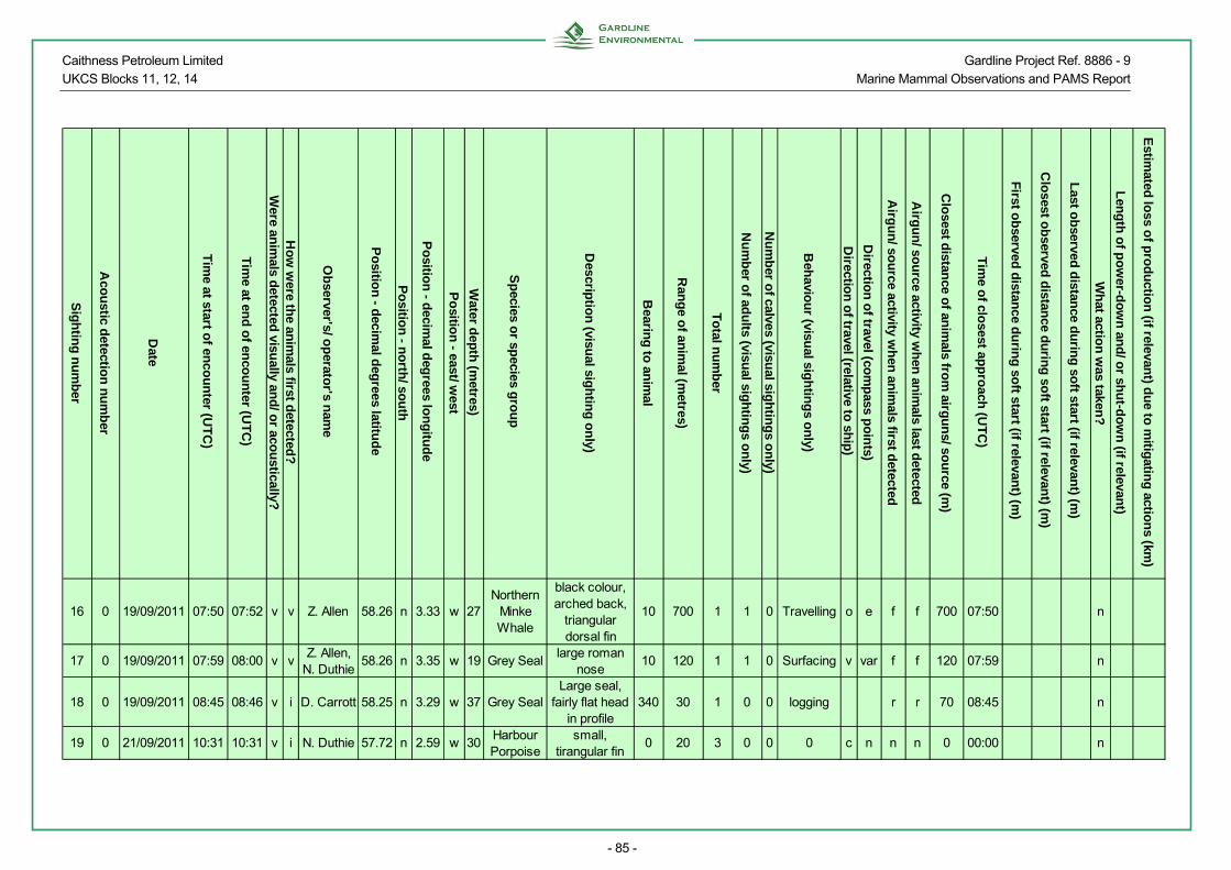
Caithness Petroleum Limited Gardline Project Ref. 8886 - 9 UKCS Blocks 11, 12, 14 Marine Mammal Observations and PAMS Report
- 85 -
Sig
htin
g n
um
ber
Aco
ustic d
etection
nu
mb
er
Date
Tim
e at start of en
cou
nter (U
TC
)
Tim
e at end
of en
cou
nter (U
TC
)
Were an
imals d
etected visu
all y and
/ or aco
ustically?
Ho
w w
ere the an
imals first d
etected?
Ob
server's/ op
erator's n
ame
Po
sition
- decim
al deg
rees latitud
e
Po
sition
- no
rth/ so
uth
Po
sition
- decim
al deg
rees lon
gitu
de
Po
sition
- east/ west
Water d
epth
(metres)
Sp
ecies or sp
ecies gro
up
Descrip
tion
(visual sig
htin
g o
nly)
Bearin
g to
anim
al
Ran
ge o
f anim
al (metres)
To
tal nu
mb
er
Nu
mb
er of ad
ults (visu
al sigh
ting
s on
ly)
Nu
mb
er of calves (visu
al sigh
ting
s on
ly)
Beh
aviou
r (visual sig
htin
gs o
nly)
Directio
n o
f travel (relative to sh
ip)
Directio
n o
f travel (com
pass p
oin
ts)
Airg
un
/ sou
rce activity wh
en an
imals first d
etected
Airg
un
/ sou
rce activity wh
en an
imals last d
etected
Clo
sest distan
ce of an
imals fro
m airg
un
s/ sou
rce (m)
Tim
e of clo
sest app
roach
(UT
C)
First o
bserved
distan
ce du
ring
soft start (if relevan
t) (m)
Clo
sest ob
served d
istance d
urin
g so
ft start (if relevant) (m
)
Last o
bserved
distan
ce du
ring
soft start (if relevan
t) (m)
Wh
at action
was taken
?
Len
gth
of p
ow
er-do
wn
and
/ or sh
ut-d
ow
n (if relevan
t)
Estim
ated lo
ss of p
rod
uctio
n (if relevan
t) du
e to m
itigatin
g actio
ns (km
)
16 0 19/09/2011 07:50 07:52 v v Z. Allen 58.26 n 3.33 w 27Northern
Minke Whale
black colour, arched back,
triangular dorsal fin
10 700 1 1 0 Travelling o e f f 700 07:50 n
17 0 19/09/2011 07:59 08:00 v vZ. Allen,
N. Duthie58.26 n 3.35 w 19 Grey Seal
large roman nose
10 120 1 1 0 Surfacing v var f f 120 07:59 n
18 0 19/09/2011 08:45 08:46 v i D. Carrott 58.25 n 3.29 w 37 Grey SealLarge seal,
fairly flat head in profile
340 30 1 0 0 logging r r 70 08:45 n
19 0 21/09/2011 10:31 10:31 v i N. Duthie 57.72 n 2.59 w 30Harbour Porpoise
small, tirangular fin
0 20 3 0 0 0 c n n n 0 00:00 n

Caithness Petroleum Limited Gardline Project Ref. 8886 - 9 UKCS Blocks 11, 12, 14 Marine Mammal Observations and PAMS Report
- 86 -
Record of Operations, Braemore Site
Date Reason for firing
Time soft start/
ramp-up began (UTC)
Time of full
power (UTC)
Time of start of
line (UTC)
Time of end of
line (UTC)
Time of reduced output
(UTC) (if relevant)
Time airguns/ source
stopped (UTC)
Time pre-shooting search began (UTC)
Time search ended (UTC)
Time PAM
began (UTC)
Time PAM
ended (UTC)
Was it day or
night in the
period prior to firing?
Was any mitigating action
required?
Comments
19/09/2011 l 14:30 14:51 14:56 15:35 15:35 13:54 14:56 13:54 14:56 d n Line 519/09/2011 l 16:32 16:52 17:02 17:46 17:46 15:36 17:03 15:36 17:03 d n Line 4
19/09/2011 l 18:41 19:02 19:11 19:59 19:59 13:54 14:56 17:46 19:13 k n
Line 10, line aborted halfway - generator problems
19/09/2011 l 23:54 00:15 00:19 00:55 00:55 23:00 00:19 n n Line 10 infill
20/09/2011 l 01:07 01:28 01:36 02:44 02:58 00:19 01:36 n nLine 11; then back to 8887 Forse
20/09/2011 l 06:18 06:39 06:48 07:31 07:31 05:29 06:48 05:07 06:48 d n Line 320/09/2011 l 08:30 08:51 08:57 09:41 09:41 07:31 08:57 07:31 08:57 d n Line 220/09/2011 l 10:42 11:03 11:09 11:59 11:59 10:00 11:09 09:41 11:09 d n Line 120/09/2011 l 12:56 13:16 13:25 14:03 14:03 11:59 13:25 11:59 13:25 d n Line 720/09/2011 l 14:59 15:20 15:29 16:07 16:07 14:03 15:29 14:03 15:29 d n Line 620/09/2011 l 17:09 17:30 17:39 18:22 18:22 16:18 17:41 16:29 17:41 d n Line 820/09/2011 l 19:28 19:52 19:59 20:43 20:43 18:23 19:59 n n Line 9

Caithness Petroleum Limited Gardline Project Ref. 8886 - 9 UKCS Blocks 11, 12, 14 Marine Mammal Observations and PAMS Report
- 87 -
Effort Forms, Braemore Site
Date
Visu
al watch
or P
AM
?
Ob
server's / op
erator's
nam
e(s)
Tim
e of start o
f watch
(UT
C)
Tim
e of en
d o
f watch
(UT
C)
Start L
atitud
e (decim
al d
egrees)
Start p
ositio
n - n
orth
/ sou
th
Start L
on
gtitu
de (d
ecimal
deg
rees)
Start p
ositio
n - east/ w
est
Dep
th o
f water at start
po
stion
(m)
En
d L
atitud
e (decim
al d
egrees)
En
d p
ositio
n - n
orth
/ sou
th
En
d lo
ng
titud
e (decim
al d
egrees)
En
d p
ositio
n - east/ w
est
Dep
th o
f water at en
d
po
sition
(m)
Sp
eed o
f vessel (kno
ts)
So
urce activity
Win
d d
irection
Win
d fo
rce (Beau
fort)
Sea state
Sw
ell
Visib
ility (visual w
atch o
nly)
Su
ng
lare (visual w
atch o
nly)
19/09/2011 v Z. Allen, N. Duthie 13:54 14:30 58.27 n 3.35 w 16.0 58.24 n 3.32 w 39.0 4.4 n sw 3 s o g w19/09/2011 p N. Russell 13:54 14:30 58.27 n 3.35 w 16.0 58.24 n 3.32 w 39.0 4.4 n sw 3 s o19/09/2011 v Z. Allen, N. Duthie 14:30 14:56 58.24 n 3.32 w 39.0 58.25 n 3.28 w 42.0 4.5 s sw 3 s o g w19/09/2011 p N. Russell 14:30 14:56 58.24 n 3.32 w 39.0 58.25 n 3.28 w 42.0 4.5 s sw 3 s o19/09/2011 v N. Duthie 14:56 15:27 58.25 n 3.28 w 42.0 58.29 n 3.26 w 37.0 4.4 f sw 3 s o g w19/09/2011 p N. Russell 14:56 15:27 58.25 n 3.28 w 42.0 58.29 n 3.26 w 37.0 4.4 f sw 3 s o19/09/2011 v N. Duthie, Z. Allen 15:27 15:36 58.29 n 3.26 w 37.0 58.3 n 3.25 w 25.1 4.2 f sw 2 s o m n19/09/2011 p N. Russell 15:27 15:36 58.29 n 3.26 w 37.0 58.3 n 3.25 w 25.1 4.2 f sw 2 s o19/09/2011 v N. Duthie, Z. Allen 15:36 16:31 58.30 n 3.25 w 25.1 58.24 n 3.30 w 39.7 4.4 r sw 3 s o m n19/09/2011 p N. Russell 15:36 16:31 58.30 n 3.25 w 25.1 58.24 n 3.30 w 39.7 4.4 r sw 3 s o19/09/2011 v N. Duthie, Z. Allen 16:31 17:03 58.24 n 3.30 w 39.7 58.25 n 3.26 w 42.0 4.4 s sw 4 c o g s19/09/2011 p N. Russell 16:31 17:03 58.24 n 3.30 w 39.7 58.25 n 3.26 w 42.0 4.4 s sw 4 c o19/09/2011 v N. Duthie 17:03 17:18 58.25 n 3.26 w 42.0 58.27 n 3.25 w 42.2 4.2 f sw 4 s o g w19/09/2011 p N. Russell 17:03 17:39 58.25 n 3.26 w 42.0 58.29 n 3.24 w 35.0 4.2 f sw 4 s o19/09/2011 v Z. Allen 17:18 17:46 58.27 n 3.25 w 42.2 58.3 n 3.23 w 25.0 4.2 f sw 4 s o g w19/09/2011 p N. Duthie 17:39 17:46 58.29 n 3.24 w 35.0 58.3 n 3.23 w 25.0 4.3 f sw 4 s o19/09/2011 v Z. Allen, N. Russell 17:46 18:40 58.30 n 3.23 w 25.0 58.25 n 3.32 w 39.0 4.3 r sw 3 s o g n19/09/2011 p N. Duthie 17:46 18:40 58.30 n 3.23 w 25.0 58.25 n 3.32 w 39.0 4.3 r sw 3 s o19/09/2011 p N. Russell 18:40 19:13 58.25 n 3.32 w 25.0 58.26 n 3.28 w 32.0 4.1 s sw 3 s o19/09/2011 p N. Russell 19:13 19:59 58.26 n 3.28 w 32.0 58.29 n 3.22 w 37.7 4.2 f sw 3 s o19/09/2011 p N. Russell 19:59 21:04 58.29 n 3.22 w 37.7 58.32 n 3.15 w 35.0 4.4 n sw 3 s o

Caithness Petroleum Limited Gardline Project Ref. 8886 - 9 UKCS Blocks 11, 12, 14 Marine Mammal Observations and PAMS Report
- 88 -
Date
Visu
al watch
or P
AM
?
Ob
server's / op
erator's
nam
e(s)
Tim
e of start o
f watch
(UT
C)
Tim
e of en
d o
f watch
(UT
C)
Start L
atitud
e (decim
al d
egrees)
Start p
ositio
n - n
orth
/ sou
th
Start L
on
gtitu
de (d
ecimal
deg
rees)
Start p
ositio
n - east/ w
est
Dep
th o
f water at start
po
stion
(m)
En
d L
atitud
e (decim
al d
egrees)
En
d p
ositio
n - n
orth
/ sou
th
En
d lo
ng
titud
e (decim
al d
egrees)
En
d p
ositio
n - east/ w
est
Dep
th o
f water at en
d
po
sition
(m)
Sp
eed o
f vessel (kno
ts)
So
urce activity
Win
d d
irection
Win
d fo
rce (Beau
fort)
Sea state
Sw
ell
Visib
ility (visual w
atch o
nly)
Su
ng
lare (visual w
atch o
nly)
19/09/2011 p N. Russell 21:04 22:16 58.32 n 3.15 w 35.0 58.26 n 3.27 w 42.5 4.3 n sw 3 s o19/09/2011 p N. Russell 22:16 23:00 58.26 n 3.27 w 42.5 58.27 n 3.26 w 34.3 4.2 n sw 3 s o19/09/2011 p K. Preston 23:00 23:54 58.27 n 3.26 w 34.3 58.27 n 3.25 w 36.4 4.2 n sw 4 s o19/09/2011 p K. Preston 23:54 23:59 58.27 n 3.25 w 36.4 58.28 n 3.23 w 37.7 4.2 s sw 4 s o20/09/2011 p K. Preston 00:00 00:19 58.28 n 3.23 w 37.7 58.29 n 3.21 w 38.5 4.2 s sw 4 s o20/09/2011 p K. Preston 00:19 00:55 58.29 n 3.21 w 38.5 58.32 n 3.16 w 40.0 4.2 f sw 4 s o20/09/2011 p K. Preston 00:55 01:07 58.32 n 3.16 w 40.0 58.33 n 3.14 w 37.0 4.2 r sw 4 s o20/09/2011 p K. Preston 01:07 01:36 58.33 n 3.14 w 37.0 58.31 n 3.18 w 34.5 4.2 s sw 4 s o20/09/2011 p K. Preston 01:36 02:44 58.31 n 3.18 w 34.5 58.26 n 3.29 w 41.5 4.3 f sw 4 s o20/09/2011 p K. Preston 05:07 06:07 58.24 n 3.42 w 18.5 58.23 n 3.30 w 41.6 4.4 n sw 3 s o20/09/2011 v Z. Allen, N. Duthie 05:29 06:07 58.23 n 3.38 w 38.9 58.23 n 3.30 w 41.6 4.4 n sw 3 s o m n20/09/2011 v Z. Allen, N. Duthie 06:07 06:18 58.23 n 3.30 w 41.6 58.23 n 3.27 w 46.4 4.4 n sw 4 c o g v20/09/2011 p K. Preston 06:07 06:18 58.23 n 3.30 w 41.6 58.23 n 3.27 w 46.4 4.4 n sw 4 c o20/09/2011 v Z. Allen, N. Duthie 06:18 06:48 58.23 n 3.27 w 46.4 58.25 n 3.24 w 46.6 4.7 s sw 4 c o g v20/09/2011 p K. Preston 06:18 06:48 58.23 n 3.27 w 46.4 58.25 n 3.24 w 46.6 4.7 s sw 4 c o20/09/2011 v Z. Allen 06:48 07:31 58.25 n 3.24 w 46.6 58.28 n 3.21 w 33.1 4.3 f sw 4 c o g v20/09/2011 p K. Preston 06:48 07:31 58.25 n 3.24 w 46.6 58.28 n 3.21 w 33.1 4.3 f sw 4 c o20/09/2011 v Z. Allen, N. Duthie 07:31 08:30 58.28 n 3.21 w 33.1 58.24 n 3.23 w 52.9 4.5 r sw 4 c o g v20/09/2011 p K. Preston 07:31 08:30 58.28 n 3.21 w 33.1 58.24 n 3.23 w 52.9 4.5 r sw 4 c o20/09/2011 v Z. Allen, N. Duthie 08:30 08:57 58.24 n 3.23 w 52.9 58.25 n 3.20 w 52.3 4.3 s sw 4 c o g v20/09/2011 p K. Preston 08:30 08:57 58.24 n 3.23 w 52.9 58.25 n 3.20 w 52.3 4.3 s sw 4 c o20/09/2011 v K. Preston 08:57 09:41 58.25 n 3.20 w 52.3 58.31 n 3.01 w 36.0 4.3 f sw 4 c o g v

Caithness Petroleum Limited Gardline Project Ref. 8886 - 9 UKCS Blocks 11, 12, 14 Marine Mammal Observations and PAMS Report
- 89 -
Date
Visu
al watch
or P
AM
?
Ob
server's / op
erator's
nam
e(s)
Tim
e of start o
f watch
(UT
C)
Tim
e of en
d o
f watch
(UT
C)
Start L
atitud
e (decim
al d
egrees)
Start p
ositio
n - n
orth
/ sou
th
Start L
on
gtitu
de (d
ecimal
deg
rees)
Start p
ositio
n - east/ w
est
Dep
th o
f water at start
po
stion
(m)
En
d L
atitud
e (decim
al d
egrees)
En
d p
ositio
n - n
orth
/ sou
th
En
d lo
ng
titud
e (decim
al d
egrees)
En
d p
ositio
n - east/ w
est
Dep
th o
f water at en
d
po
sition
(m)
Sp
eed o
f vessel (kno
ts)
So
urce activity
Win
d d
irection
Win
d fo
rce (Beau
fort)
Sea state
Sw
ell
Visib
ility (visual w
atch o
nly)
Su
ng
lare (visual w
atch o
nly)
20/09/2011 p N. Duthie 08:57 09:41 58.25 n 3.20 w 52.3 58.31 n 3.01 w 36.0 4.3 f sw 4 c o20/09/2011 v K. Preston 09:41 10:17 58.31 n 3.01 w 36.0 58.27 n 3.21 w 48.0 4.2 r sw 5 c o g v20/09/2011 p N. Duthie 09:41 10:17 58.31 n 3.01 w 36.0 58.27 n 3.21 w 48.0 4.2 r sw 5 c o20/09/2011 v Z. Allen, K. Preston 10:17 10:42 58.27 n 3.21 w 48.0 58.24 n 3.21 w 49.0 4.2 r sw 5 c o g v20/09/2011 p N. Duthie 10:17 10:42 58.27 n 3.21 w 48.0 58.24 n 3.21 w 49.0 4.2 r sw 5 c o20/09/2011 v Z. Allen, K. Preston 10:42 11:00 58.24 n 3.21 w 49.0 58.24 n 3.18 w 60.0 4.2 s sw 5 c o g v20/09/2011 p N. Duthie 10:42 11:00 58.24 n 3.21 w 49.0 58.24 n 3.18 w 60.0 4.2 s sw 5 c o20/09/2011 v N. Russell, K. Preston 11:00 11:09 58.24 n 3.18 w 60.0 58.01 n 3.05 w 55.0 4.2 s sw 5 c o g v20/09/2011 p N. Duthie 11:00 11:09 58.24 n 3.18 w 60.0 58.01 n 3.05 w 55.0 4.2 s sw 5 c o20/09/2011 v N. Russell, Z. Allen 11:09 11:59 58.01 n 3.05 w 55.0 58.31 n 3.19 w 34.0 4.4 f sw 5 c o g v20/09/2011 p N. Duthie 11:09 11:59 58.01 n 3.05 w 55.0 58.31 n 3.19 w 34.0 4.4 f sw 5 c o20/09/2011 v N. Russell, Z. Allen 11:59 12:56 58.31 n 3.19 w 34.0 58.26 n 3.16 w 66.0 4.2 n sw 5 c o g v20/09/2011 p N. Duthie 11:59 12:56 58.31 n 3.19 w 34.0 58.26 n 3.16 w 66.0 4.2 n sw 5 c o20/09/2011 v N. Russell, Z. Allen 12:56 13:25 58.26 n 3.16 w 66.0 58.28 n 3.15 w 59.0 4.2 s sw 5 c o g v20/09/2011 p N. Duthie 12:56 13:25 58.26 n 3.16 w 66.0 58.28 n 3.15 w 59.0 4.2 s sw 5 c o20/09/2011 v N. Russell, N. Duthie 13:25 14:03 58.28 n 3.15 w 59.0 58.31 n 3.20 w 30.5 4.2 f sw 5 c o g s20/09/2011 p Z. Allen 13:25 14:03 58.28 n 3.15 w 59.0 58.31 n 3.20 w 30.5 4.2 f sw 5 c o20/09/2011 v N. Russell, N. Duthie 14:03 14:38 58.31 n 3.20 w 30.5 58.27 n 3.18 w 53.5 4.2 r sw 5 c o g s20/09/2011 p Z. Allen 14:03 14:38 58.31 n 3.20 w 30.5 58.27 n 3.18 w 53.5 4.2 r sw 5 c o20/09/2011 v N. Russell, N. Duthie 14:38 14:59 58.27 n 3.18 w 53.5 58.25 n 3.16 w 66.0 4.3 r sw 6 r o g s20/09/2011 p Z. Allen 14:38 14:59 58.27 n 3.18 w 53.5 58.25 n 3.16 w 66.0 4.3 r sw 6 r o20/09/2011 v N. Russell, N. Duthie 14:59 15:29 58.25 n 3.16 w 66.0 58.27 n 3.16 w 61.0 4.2 s sw 6 r o g s

Caithness Petroleum Limited Gardline Project Ref. 8886 - 9 UKCS Blocks 11, 12, 14 Marine Mammal Observations and PAMS Report
- 90 -
Date
Visu
al watch
or P
AM
?
Ob
server's / op
erator's
nam
e(s)
Tim
e of start o
f watch
(UT
C)
Tim
e of en
d o
f watch
(UT
C)
Start L
atitud
e (decim
al d
egrees)
Start p
ositio
n - n
orth
/ sou
th
Start L
on
gtitu
de (d
ecimal
deg
rees)
Start p
ositio
n - east/ w
est
Dep
th o
f water at start
po
stion
(m)
En
d L
atitud
e (decim
al d
egrees)
En
d p
ositio
n - n
orth
/ sou
th
En
d lo
ng
titud
e (decim
al d
egrees)
En
d p
ositio
n - east/ w
est
Dep
th o
f water at en
d
po
sition
(m)
Sp
eed o
f vessel (kno
ts)
So
urce activity
Win
d d
irection
Win
d fo
rce (Beau
fort)
Sea state
Sw
ell
Visib
ility (visual w
atch o
nly)
Su
ng
lare (visual w
atch o
nly)
20/09/2011 p Z. Allen 14:59 15:29 58.25 n 3.16 w 66.0 58.27 n 3.16 w 61.0 4.2 s sw 6 r o20/09/2011 v N. Russell, N. Duthie 15:29 15:58 58.27 n 3.16 w 61.0 58.3 n 3.21 w 37.3 4.1 f sw 5 c o g s20/09/2011 p Z. Allen 15:29 16:07 58.27 n 3.16 w 61.0 58.3 n 3.21 w 33.0 4.1 f sw 5 c o20/09/2011 v N. Russell 15:58 16:07 58.30 n 3.21 w 37.3 58.3 n 3.21 w 33.0 4.5 f sw 5 c o g s20/09/2011 v N. Russell 16:07 16:18 58.30 n 3.21 w 33.0 58.29 n 3.22 w 36.5 4.4 r sw 5 c o g s20/09/2011 p Z. Allen 16:07 16:29 58.30 n 3.21 w 33.0 58.28 n 3.23 w 37.7 4.4 r sw 5 c o20/09/2011 v N. Duthie 16:18 16:40 58.29 n 3.22 w 36.5 58.27 n 3.21 w 60.2 4.4 r sw 5 c o g s20/09/2011 p N. Russell 16:29 17:09 58.28 n 3.23 w 37.7 58.24 n 3.17 w 63.8 4.8 r sw 5 c o20/09/2011 v Z. Allen, N. Duthie 16:40 17:09 58.27 n 3.21 w 60.2 58.24 n 3.17 w 63.8 4.4 r sw 5 c o g s20/09/2011 v Z. Allen, N. Duthie 17:09 17:41 58.24 n 3.17 w 63.8 58.26 n 3.17 w 60.2 4.2 s sw 5 c o g s20/09/2011 p N. Russell 17:09 17:41 58.24 n 3.17 w 63.8 58.26 n 3.17 w 60.2 4.2 s sw 5 c o20/09/2011 v Z. Allen, N. Duthie 17:41 17:53 58.26 n 3.17 w 60.2 58.27 n 3.19 w 51.3 4.5 f sw 5 c o g w20/09/2011 p N. Russell 17:41 18:23 58.26 n 3.17 w 60.2 58.3 n 3.23 w 25.3 4.5 f sw 5 c o20/09/2011 v Z. Allen, N. Duthie 17:53 18:23 58.27 n 3.19 w 51.3 58.3 n 3.23 w 25.3 4.4 f sw 5 c o g n20/09/2011 v Z. Allen, N. Duthie 18:23 18:41 58.30 n 3.23 w 25.3 58.28 n 3.24 w 34.0 4.6 r sw 5 c o g n20/09/2011 p N. Russell 18:23 19:20 58.30 n 3.23 w 25.3 58.24 n 3.19 w 60.0 4.2 r sw 5 c o20/09/2011 p N. Russell 19:20 19:28 58.24 n 3.19 w 60.0 58.23 n 3.18 w 60.7 4.1 r sw 5 c o20/09/2011 p N. Russell 19:28 19:59 58.23 n 3.18 w 60.7 58.26 n 3.19 w 56.7 4.2 s sw 5 c o20/09/2011 p N. Russell 19:59 20:43 58.26 n 3.19 w 56.7 58.3 n 3.25 w 29.0 4.5 f sw 5 c o

Caithness Petroleum Limited Gardline Project Ref. 8886 - 9 UKCS Blocks 11, 12, 14 Marine Mammal Observations and PAMS Report
- 91 -
Sightings, Braemore Site
Sig
htin
g n
um
ber
Date
Tim
e at start of en
cou
nter (U
TC
)
Tim
e at end
of en
cou
nter (U
TC
)
Were an
imals d
etected visu
ally and
/ or aco
ustically?
Ho
w w
ere the an
imals first d
etected?
Ob
server's/ op
erator's n
ame
Po
sition
- decim
al deg
rees latitud
e
Po
sition
- no
rth/ so
uth
Po
sition
- decim
al deg
rees lon
gitu
de
Po
sition
- east/ west
Water d
epth
(metres)
Sp
ecies or sp
ecies gro
up
Descrip
tion
(visual sig
htin
g o
nly)
Bearin
g to
anim
al
Ran
ge o
f anim
al (metres)
To
tal nu
mb
er
Nu
mb
er of ad
ults (visu
al sigh
ting
s on
ly)
Nu
mb
er of calves (visu
al sigh
ting
s on
ly)
Beh
aviou
r (visual sig
htin
gs o
nly)
Directio
n o
f travel (relative to sh
ip)
Directio
n o
f travel (com
pass p
oin
ts)
Airg
un
/ sou
rce activity wh
en an
imals first d
etected
Airg
un
/ sou
rce activity wh
en an
imals last d
etected
Clo
sest distan
ce of an
imals fro
m airg
un
s/ sou
rce (m)
Tim
e of clo
sest app
roach
(UT
C)
First o
bserved
distan
ce du
ring
soft start (if relevan
t) (m)
Clo
sest ob
served d
istance d
urin
g so
ft start (if relevant) (m
)
Last o
bserved
distan
ce du
ring
soft start (if relevan
t) (m)
Wh
at action
was taken
?
1 19/09/2011 0.7 0.7 v vZ. Allen, N. Duthie 58.24 n 3.29 w 40 Grey Seal
Long snout, dark brown 205 150 1 1 0 Porpoising c nw r r 150 0.7 0 0 0 n

Caithness Petroleum Limited Gardline Project Ref. 8886 - 9 UKCS Blocks 11, 12, 14 Marine Mammal Observations and PAMS Report
- 92 -
Record of Operations, Burrigill Site
Date Reason for firing
Time soft start/
ramp-up began (UTC)
Time of full
power (UTC)
Time of start of
line (UTC)
Time of end of
line (UTC)
Time of reduced output
(UTC) (if relevant)
Time airguns/ source
stopped (UTC)
Time pre-shooting search began (UTC)
Time search ended (UTC)
Time PAM
began (UTC)
Time PAM
ended (UTC)
Was it day or
night in the
period prior to firing?
Was any mitigating
action required?
Comments
22/09/2011 t 19:52 20:12 20:12 20:15 20:15 19:00 20:37 n n test line22/09/2011 l 20:16 20:36 20:37 21:06 21:06 19:00 20:37 n n Line 1822/09/2011 l 21:09 21:29 21:30 22:00 22:00 20:37 21:30 n n Line 1122/09/2011 l 22:01 22:22 22:34 23:04 23:04 21:30 22:35 n n Line 1722/09/2011 l 23:05 23:26 23:35 00:06 00:06 22:35 23:05 n n Line 1023/09/2011 l 00:07 00:27 00:39 01:09 01:09 23:05 00:39 n n Line 1623/09/2011 l 01:10 01:31 01:42 02:12 02:12 00:39 01:42 n n Line 923/09/2011 l 02:14 02:34 02:45 03:16 03:16 01:42 02:45 n n Line 1523/09/2011 l 03:17 03:37 03:48 04:17 04:17 02:45 03:48 n n Line 823/09/2011 l 04:19 04:39 04:50 05:20 05:20 03:48 04:50 n n Line 1423/09/2011 l 05:21 05:41 05:53 06:22 06:22 04:50 05:53 n n Line 723/09/2011 l 06:23 06:45 06:54 07:24 07:24 05:53 06:54 05:53 06:54 d n Line 1323/09/2011 l 07:25 07:45 07:56 08:26 08:26 06:54 07:56 06:54 07:56 d n Line 623/09/2011 l 08:27 08:48 08:55 09:26 09:26 07:56 08:55 07:56 08:55 d n Line 18A23/09/2011 l 09:26 09:46 09:56 10:26 00:00 10:30 08:55 09:56 08:55 09:56 d n Line 1223/09/2011 l 11:01 11:21 11:27 11:57 11:57 09:56 11:28 09:56 11:28 d n Line 523/09/2011 l 11:58 12:19 12:28 12:56 12:56 11:28 12:28 11:28 12:28 d n Line 223/09/2011 l 12:58 13:18 13:28 13:58 13:58 12:28 13:18 12:28 13:18 d n Line 423/09/2011 l 13:59 14:19 14:29 14:45 00:00 14:45 13:18 14:29 13:18 14:29 d n Line 123/09/2011 l 18:09 18:29 18:41 18:56 18:56 00:00 16:55 18:16 16:14 19:28 k n Line 1A23/09/2011 l 18:57 19:17 19:27 19:56 00:00 19:56 16:14 19:28 n n Line 3
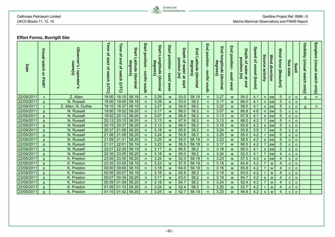
Caithness Petroleum Limited Gardline Project Ref. 8886 - 9 UKCS Blocks 11, 12, 14 Marine Mammal Observations and PAMS Report
- 93 -
Effort Forms, Burrigill Site
Date
Visu
al watch
or P
AM
?
Ob
server's / op
erator's
nam
e(s)
Tim
e o
f sta
rt of w
atch
(UT
C)
Tim
e of e
nd
of w
atc
h (U
TC
)
Start L
atitu
de (d
ecim
al
deg
rees)
Start p
ositio
n - n
orth
/ sou
th
Start L
on
gtitu
de (d
ecimal
deg
rees)
Start p
ositio
n - e
ast/ w
est
Dep
th o
f water at start
po
stion
(m)
En
d L
atitud
e (decim
al d
egrees)
En
d p
ositio
n - n
orth
/ sou
th
En
d lo
ng
titud
e (decim
al d
egrees)
En
d p
ositio
n - east/ w
est
Dep
th o
f water at en
d
po
sitio
n (m
)
Sp
eed o
f vessel (kno
ts)
So
urce activity
Win
d d
irection
Win
d fo
rce
(Beau
fort)
Sea state
Sw
ell
Vis
ibility
(visual w
atch
on
ly)
Su
ng
lare (visual w
atch o
nly)
22/09/2011 v Z. Allen 18:00 18:10 58.18 n 3.29 w 53.0 58.19 n 3.27 w 54.0 4.1 n sw 5 c o g n22/09/2011 p N. Russell 18:00 19:00 58.18 n 3.29 w 53.0 58.2 n 3.17 w 66.0 4.1 n sw 5 c o22/09/2011 v Z. Allen, N. Duthie 18:10 18:37 58.19 n 3.27 w 54.0 58.2 n 3.22 w 59.5 4.1 n sw 5 c o g n22/09/2011 p N. Russell 19:00 19:52 58.20 n 3.17 w 66.0 58.2 n 3.07 w 68.8 4.6 n sw 5 c o22/09/2011 p N. Russell 19:52 20:12 58.20 n 3.07 w 68.8 58.2 n 3.13 w 67.9 4.1 s sw 5 c o22/09/2011 p N. Russell 20:12 20:15 58.20 n 3.13 w 67.9 58.2 n 3.13 w 68.0 4.2 f sw 5 c o22/09/2011 p N. Russell 20:15 20:37 58.20 n 3.13 w 68.0 58.2 n 3.18 w 65.6 4.3 s sw 5 c o22/09/2011 p N. Russell 20:37 21:06 58.20 n 3.18 w 65.6 58.2 n 3.24 w 55.8 3.9 f sw 5 c o22/09/2011 p N. Russell 21:06 21:09 58.20 n 3.24 w 55.8 58.2 n 3.25 w 55.0 4.2 r sw 5 c o22/09/2011 p N. Russell 21:09 21:31 58.20 n 3.25 w 55.0 58.19 n 3.23 w 58.5 4.2 s sw 5 c o22/09/2011 p N. Russell 21:31 22:01 58.19 n 3.23 w 58.5 58.19 n 3.17 w 66.5 4.2 f sw 5 c o22/09/2011 p N. Russell 22:01 22:35 58.19 n 3.17 w 66.5 58.2 n 3.18 w 65.0 4.1 s sw 5 c o22/09/2011 p N. Russell 22:35 23:05 58.20 n 3.18 w 65.0 58.2 n 3.24 w 52.0 4.1 f sw 4 c o22/09/2011 p K. Preston 23:05 23:35 58.20 n 3.24 w 52.0 58.19 n 3.23 w 57.5 4.3 s sw 4 c o22/09/2011 p K. Preston 23:35 23:59 58.19 n 3.23 w 57.5 58.19 n 3.18 w 64.9 4.2 f w 4 c o23/09/2011 p K. Preston 00:00 00:06 58.19 n 3.18 w 64.9 58.19 n 3.16 w 65.8 4.2 f w 4 c o23/09/2011 p K. Preston 00:06 00:07 58.19 n 3.16 w 65.8 58.2 n 3.18 w 63.0 4.2 r w 4 c o23/09/2011 p K. Preston 00:07 00:39 58.20 n 3.17 w 63.0 58.2 n 3.18 w 64.7 4.2 s w 4 c o23/09/2011 p K. Preston 00:39 01:09 58.20 n 3.18 w 64.7 58.2 n 3.24 w 52.4 4.2 f w 4 c o23/09/2011 p K. Preston 01:09 01:10 58.20 n 3.24 w 52.4 58.2 n 3.25 w 52.7 4.2 r w 4 c o23/09/2011 p K. Preston 01:10 01:42 58.20 n 3.25 w 52.7 58.19 n 3.23 w 56.8 4.2 s w 4 c o

Caithness Petroleum Limited Gardline Project Ref. 8886 - 9 UKCS Blocks 11, 12, 14 Marine Mammal Observations and PAMS Report
- 94 -
Date
Visu
al wa
tch o
r PA
M?
Ob
server's / op
erator's
nam
e(s)
Tim
e of start o
f watch
(UT
C)
Tim
e of e
nd
of w
atch (U
TC
)
Sta
rt La
titud
e (decim
al d
egrees
)
Start p
os
ition
- no
rth/ so
uth
Start L
on
gtitu
de (d
ecim
al d
egrees
)
Start p
ositio
n - east/ w
est
Dep
th o
f water at start
po
stion
(m)
En
d L
atitud
e (decim
al d
egrees
)
En
d p
ositio
n - n
orth
/ sou
th
En
d lo
ng
titud
e (decim
al d
egrees
)
En
d p
ositio
n - eas
t/ west
Dep
th o
f water at en
d
po
sition
(m)
Sp
eed o
f vessel (kn
ots)
So
urce activity
Win
d d
irection
Win
d fo
rce (B
eau
fort)
Se
a state
Sw
ell
Visib
ility (visual w
atch o
nly)
Su
ng
lare (visual w
atch o
nly)
23/09/2011 p K. Preston 01:42 02:12 58.19 n 3.23 w 56.8 58.19 n 3.16 w 65.2 4.1 f w 4 c o23/09/2011 p K. Preston 02:12 02:14 58.19 n 3.16 w 65.2 58.19 n 3.16 w 64.7 4.3 r w 4 c o23/09/2011 p K. Preston 02:14 02:45 58.19 n 3.16 w 64.7 58.2 n 3.18 w 64.3 4.3 s w 4 c o23/09/2011 p K. Preston 02:45 03:16 58.20 n 3.18 w 64.3 58.2 n 3.24 w 62.1 4.3 f w 4 c o23/09/2011 p K. Preston 03:16 03:17 58.20 n 3.24 w 62.1 58.2 n 3.25 w 62.4 4.3 r w 4 c o23/09/2011 p K. Preston 03:17 03:48 58.20 n 3.25 w 62.4 58.19 n 3.23 w 57.5 4.1 s w 4 c o23/09/2011 p K. Preston 03:48 04:17 58.19 n 3.23 w 57.5 58.19 n 3.16 w 64.9 4.2 f w 4 c o23/09/2011 p K. Preston 04:17 04:19 58.19 n 3.16 w 64.9 58.19 n 3.16 w 65.8 4.2 r w 4 s o23/09/2011 p K. Preston 04:19 05:20 58.19 n 3.16 w 65.8 58.19 n 3.24 w 54.3 4.3 s s 4 s o23/09/2011 p K. Preston 05:20 05:20 58.19 n 3.24 w 54.3 58.19 n 3.25 w 54.6 4.3 r s 4 s o23/09/2011 p K. Preston 05:20 05:53 58.19 n 3.25 w 54.6 58.19 n 3.24 w 56.0 4.3 s s 4 s o23/09/2011 v Z. Allen, N. Duthie 05:53 06:22 58.19 n 3.24 w 56.0 58.19 n 3.16 w 56.5 4.3 f s 4 s o m n23/09/2011 p K. Preston 05:53 06:22 58.19 n 3.24 w 56.0 58.19 n 3.16 w 56.0 4.3 f s 4 s o23/09/2011 v Z. Allen, N. Duthie 06:22 06:23 58.19 n 3.16 w 56.5 58.19 n 3.16 w 56.6 4.3 r s 4 s o m n23/09/2011 p K. Preston 06:22 06:23 58.19 n 3.16 w 56.5 58.19 n 3.16 w 56.6 4.3 r s 4 s o23/09/2011 v Z. Allen, N. Duthie 06:23 06:54 58.19 n 3.16 w 56.6 58.19 n 3.18 w 65.9 4.3 s s 4 s o m n23/09/2011 p K. Preston 06:23 06:54 58.19 n 3.16 w 56.6 58.19 n 3.18 w 65.9 4.3 s s 4 s o23/09/2011 v Z. Allen, N. Duthie 06:54 07:24 58.19 n 3.18 w 65.9 58.19 n 3.24 w 55.7 4.3 f s 4 s o m n23/09/2011 p K. Preston 06:54 07:24 58.19 n 3.18 w 65.9 58.19 n 3.24 w 55.7 4.3 f s 4 s o23/09/2011 v Z. Allen, N. Duthie 07:24 07:25 58.19 n 3.24 w 55.7 58.19 n 3.25 w 55.4 4.3 r s 4 s o m n23/09/2011 p K. Preston 07:24 07:25 58.19 n 3.24 w 55.7 58.19 n 3.25 w 55.4 4.3 r s 4 s o23/09/2011 v Z. Allen, N. Duthie 07:25 07:56 58.19 n 3.25 w 55.4 58.19 n 3.23 w 57.5 4.3 s s 4 s o m n23/09/2011 p K. Preston 07:25 07:56 58.19 n 3.25 w 55.4 58.19 n 3.23 w 57.5 4.3 s s 4 s o

Caithness Petroleum Limited Gardline Project Ref. 8886 - 9 UKCS Blocks 11, 12, 14 Marine Mammal Observations and PAMS Report
- 95 -
Date
Visu
al watch
or P
AM
?
Ob
server's / op
erator's
nam
e(s)
Tim
e of start o
f watch
(UT
C)
Tim
e of en
d o
f watch
(UT
C)
Start L
atitud
e (decim
al d
egrees)
Start p
os
ition
- no
rth/ so
uth
Start L
on
gtitu
de (d
ecimal
deg
rees)
Sta
rt po
sition
- east/ west
Dep
th o
f water at start
po
stio
n (m
)
En
d L
atitud
e (decim
al d
egrees)
En
d p
ositio
n - n
orth
/ sou
th
En
d lo
ng
titud
e (decim
al d
egrees)
En
d p
ositio
n - east/ w
est
Dep
th o
f water at en
d
po
sition
(m)
Sp
eed
of vess
el (kno
ts)
So
urce activity
Win
d d
irection
Win
d fo
rce (Beau
fort)
Sea state
Sw
ell
Visib
ility (visual w
atch o
nly)
Su
ng
lare (visual w
atch o
nly)
23/09/2011 v Z. Allen, N. Duthie 07:56 08:27 58.19 n 3.23 w 57.5 58.19 n 3.13 w 66.8 4.2 f s 4 s o m n23/09/2011 p K. Preston 07:56 08:27 58.19 n 3.23 w 57.5 58.19 n 3.13 w 66.8 4.2 f s 4 s o23/09/2011 v Z. Allen, N. Duthie 08:27 08:28 58.19 n 3.13 w 66.8 58.19 n 3.16 w 66.4 4.2 r s 4 s o m w23/09/2011 p K. Preston 08:27 08:28 58.19 n 3.13 w 66.8 58.19 n 3.16 w 66.4 4.2 r s 4 s o23/09/2011 v Z. Allen, N. Duthie 08:28 08:55 58.19 n 3.16 w 66.4 58.2 n 3.18 w 64.6 4.2 s s 4 s o m w23/09/2011 p K. Preston 08:28 08:55 58.19 n 3.16 w 66.4 58.2 n 3.18 w 64.6 4.2 s s 4 s o23/09/2011 v Z. Allen, N. Duthie 08:55 09:25 58.20 n 3.18 w 64.6 58.2 n 3.24 w 54.0 4.2 f s 4 s o m v23/09/2011 p K. Preston 08:55 09:25 58.20 n 3.18 w 64.6 58.2 n 3.24 w 54.0 4.2 f s 4 s o23/09/2011 v Z. Allen, N. Duthie 09:25 09:26 58.20 n 3.24 w 54.0 58.2 n 3.25 w 53.9 4.2 r s 4 s o m v23/09/2011 p K. Preston 09:25 09:26 58.20 n 3.24 w 54.0 58.2 n 3.25 w 53.9 4.2 r s 4 s o23/09/2011 v Z. Allen, N. Duthie 09:26 09:56 58.20 n 3.25 w 53.9 58.2 n 3.24 w 57.0 4.2 s s 4 s o m v23/09/2011 p K. Preston 09:26 09:56 58.20 n 3.25 w 53.9 58.2 n 3.24 w 57.0 4.2 s s 4 s o23/09/2011 v Z. Allen, N. Duthie 09:56 10:26 58.20 n 3.24 w 57.0 58.19 n 3.16 w 66.6 4.2 f s 4 s o m v23/09/2011 p K. Preston 09:56 10:26 58.20 n 3.24 w 57.0 58.19 n 3.16 w 66.6 4.2 f s 4 s o23/09/2011 v N. Duthie 10:26 10:42 58.19 n 3.16 w 66.6 58.21 n 3.16 w 65.5 4.2 r s 4 s o m v23/09/2011 p K. Preston 10:26 10:42 58.19 n 3.16 w 66.6 58.21 n 3.16 w 65.5 4.2 r s 4 s o23/09/2011 v Z. Allen 10:42 11:03 58.21 n 3.16 w 65.5 58.23 n 3.19 w 60.0 3.9 r s 4 s o m v23/09/2011 p K. Preston 10:42 11:03 58.21 n 3.16 w 65.5 58.23 n 3.19 w 60.0 3.9 r s 4 s o23/09/2011 v Z. Allen, K. Preston 11:03 11:05 58.23 n 3.19 w 60.0 58.23 n 3.19 w 59.5 4.2 s s 4 s o g v23/09/2011 p N. Russell 11:03 11:28 58.23 n 3.19 w 60.0 58.21 n 3.20 w 65.6 4.2 s s 4 s o23/09/2011 v Z. Allen, N. Duthie 11:05 11:28 58.23 n 3.19 w 59.5 58.21 n 3.20 w 65.6 4.4 s s 4 s o g v23/09/2011 v Z. Allen, N. Duthie 11:28 11:57 58.21 n 3.20 w 65.6 58.17 n 3.20 w 64.0 4.1 f s 4 s o g w

Caithness Petroleum Limited Gardline Project Ref. 8886 - 9 UKCS Blocks 11, 12, 14 Marine Mammal Observations and PAMS Report
- 96 -
Da
te
Visu
al watch
or P
AM
?
Ob
server's / op
erator's
nam
e(s)
Tim
e of s
tart of w
atch
(UT
C)
Tim
e of en
d o
f wa
tch
(UT
C)
Start L
atitu
de
(de
cimal
deg
rees)
Start p
ositio
n - n
orth
/ sou
th
Sta
rt Lo
ng
titud
e (d
ec
ima
l d
egrees)
Start p
ositio
n - east/ w
est
Dep
th o
f water at start
po
stion
(m)
En
d L
atitud
e (decim
al d
egrees)
En
d p
ositio
n - n
orth
/ sou
th
En
d lo
ng
titud
e (de
cim
al
deg
rees)
En
d p
ositio
n - east/ w
est
Dep
th o
f water at en
d
po
sition
(m)
Sp
eed o
f vessel (kno
ts)
So
urce activity
Win
d d
irection
Win
d fo
rce (Beau
fort)
Sea state
Sw
ell
Vis
ibility
(visu
al w
atch
on
ly)
Su
ng
lare (visual w
atch o
nly)
23/09/2011 p N. Russell 11:28 11:57 58.21 n 3.20 w 65.6 58.17 n 3.20 w 64.0 4.1 f s 4 s o23/09/2011 v Z. Allen, N. Duthie 11:57 11:58 58.17 n 3.20 w 64.0 58.17 n 3.20 w 62.7 4.1 r s 4 s o g w23/09/2011 p N. Russell 11:57 11:58 58.17 n 3.20 w 64.0 58.17 n 3.20 w 62.7 4.1 r s 4 s o23/09/2011 v Z. Allen, N. Duthie 11:58 12:29 58.17 n 3.20 w 62.7 58.18 n 3.20 w 62.0 4.2 s s 4 s o g v23/09/2011 p N. Russell 11:58 12:29 58.17 n 3.20 w 62.7 58.18 n 3.20 w 62.0 4.2 s s 4 s o23/09/2011 v Z. Allen, N. Duthie 12:29 12:56 58.18 n 3.20 w 62.0 58.22 n 3.20 w 59.6 4.6 f s 4 s o g s23/09/2011 p N. Russell 12:29 12:56 58.18 n 3.20 w 62.0 58.22 n 3.20 w 59.6 4.6 f s 4 s o23/09/2011 v Z. Allen, N. Duthie 12:56 12:58 58.22 n 3.20 w 59.6 58.22 n 3.20 w 59.7 4.7 r s 4 s o g w23/09/2011 p N. Russell 12:56 12:58 58.22 n 3.20 w 59.6 58.22 n 3.20 w 59.7 4.7 r s 4 s o23/09/2011 v Z. Allen, N. Duthie 12:58 13:28 58.22 n 3.20 w 59.7 58.21 n 3.21 w 57.7 4.7 s s 4 s o g v23/09/2011 p N. Russell 12:58 13:28 58.22 n 3.20 w 59.7 58.21 n 3.21 w 57.7 4.7 s s 4 s o23/09/2011 v Z. Allen, N. Duthie 13:28 13:58 58.21 n 3.21 w 57.7 58.17 n 3.21 w 62.7 4.4 f s 4 s o g v23/09/2011 p N. Russell 13:28 13:58 58.21 n 3.21 w 57.7 58.17 n 3.21 w 62.7 4.4 f s 4 s o23/09/2011 v Z. Allen, N. Duthie 13:58 14:30 58.17 n 3.21 w 62.7 58.18 n 3.20 w 62.3 4.2 s s 3 s o g v23/09/2011 p N. Russell 13:58 14:30 58.17 n 3.21 w 62.7 58.18 n 3.20 w 62.3 4.2 s s 3 s o23/09/2011 v Z. Allen, N. Duthie 14:30 14:45 58.18 n 3.20 w 62.3 58.2 n 3.20 w 59.7 4.3 f s 3 s o g v23/09/2011 p N. Russell 14:30 14:45 58.18 n 3.20 w 62.3 58.2 n 3.20 w 59.7 4.3 f s 3 s o23/09/2011 p N. Russell 14:45 15:53 58.20 n 3.20 w 59.7 58.18 n 3.20 w 62.6 4.3 n s 3 s o23/09/2011 p N. Russell 15:53 16:14 58.18 n 3.20 w 62.6 58.2 n 3.20 w 60.7 4.3 n s 3 s o23/09/2011 p Z. Allen 16:14 17:38 58.20 n 3.20 w 60.7 58.2 n 3.22 w 57.9 4.1 n sw 4 c o23/09/2011 v N. Russell, N. Duthie 16:55 17:38 58.18 n 3.21 w 63.4 58.2 n 3.22 w 57.9 4.3 n sw 4 c o g n23/09/2011 p Z. Allen 17:38 18:09 58.20 n 3.22 w 57.9 58.17 n 3.21 w 63.8 4.0 n sw 4 c o23/09/2011 v N. Russell, N. Duthie 17:38 18:09 58.20 n 3.22 w 57.9 58.17 n 3.21 w 63.8 4.0 n sw 4 c o g n

Caithness Petroleum Limited Gardline Project Ref. 8886 - 9 UKCS Blocks 11, 12, 14 Marine Mammal Observations and PAMS Report
- 97 -
Date
Visu
al watch
or P
AM
?
Ob
server's / op
erator's
nam
e(s)
Tim
e of start o
f watch
(UT
C)
Tim
e of en
d o
f watch
(UT
C)
Start L
atitud
e (decim
al d
egrees)
Start p
ositio
n - n
orth
/ sou
th
Start L
on
gtitu
de (d
ecimal
deg
rees)
Start p
ositio
n - east/ w
est
Dep
th o
f water at start
po
stion
(m)
En
d L
atitud
e (decim
al d
egrees)
En
d p
ositio
n - n
orth
/ sou
th
En
d lo
ng
titud
e (decim
al d
egrees)
En
d p
ositio
n - east/ w
est
Dep
th o
f water at en
d
po
sition
(m)
Sp
eed o
f vessel (kno
ts)
So
urce activity
Win
d d
irection
Win
d fo
rce (Beau
fort)
Sea state
Sw
ell
Visib
ility (visual w
atch o
nly)
Su
ng
lare (visual w
atch o
nly)
23/09/2011 p Z. Allen 18:09 18:16 58.17 n 3.21 w 63.8 58.17 n 3.20 w 63.9 4.0 s sw 4 c o23/09/2011 v N. Russell, N. Duthie 18:09 18:16 58.17 n 3.21 w 63.8 58.17 n 3.20 w 63.9 4.0 s sw 4 c o g n23/09/2011 p N. Russell 18:16 18:41 58.17 n 3.20 w 63.9 58.19 n 3.20 w 61.2 4.5 s sw 4 c o23/09/2011 p N. Russell 18:41 18:56 58.19 n 3.20 w 61.2 58.22 n 3.20 w 60.2 4.3 f sw 4 c o23/09/2011 p N. Russell 18:56 18:57 58.22 n 3.20 w 60.2 58.22 n 3.20 w 60.2 4.2 r sw 4 c o23/09/2011 p N. Russell 18:57 19:28 58.22 n 3.20 w 60.2 58.21 n 3.21 w 61.1 4.2 s sw 4 c o23/09/2011 p N. Russell 19:28 19:57 58.21 n 3.21 w 61.1 58.21 n 3.21 w 64.5 4.3 f sw 4 c o23/09/2011 p N. Russell 19:57 20:12 58.21 n 3.21 w 64.5 58.16 n 3.21 w 0.0 4.3 f sw 4 c o