calder vale - wyre · 1. introduction conservation areas purpose and objectives of a conservation...
TRANSCRIPT
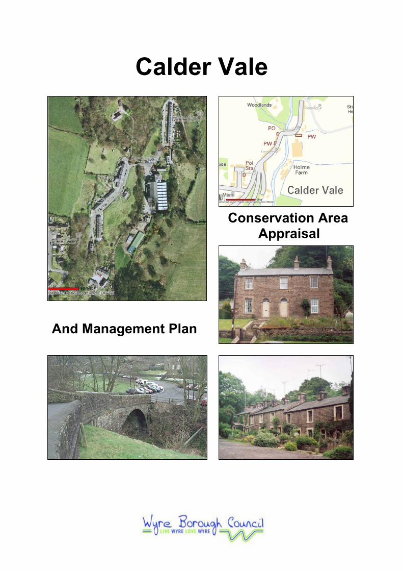
Calder Vale
Conservation Area Appraisal
And Management Plan

Calder Vale Conservation Area Appraisal
WYRE BOROUGH COUNCIL
Adopted: 13th August 2007
CONTENTS
Acknowledgements
1. Introduction Conservation Areas Purpose and Objectives of a Conservation Area Character Appraisal Calder Vale Conservation Area
2. Community Involvement
3. Historical Development
19th Century Calder Vale 20th Century – Present Calder Vale
4. Character Appraisal
Topography, Views and Vistas Activity and Former Uses Buildings Public Realm Audit Open Spaces and Footpaths Trees Architecture and Materials
5. Pressures, Issues and Threats
Pressures Issues and Threats
6. Opportunities, Enhancements and Improvements
Opportunities Recommendations for Enhancements and Improvements Suggested Boundary Changes
7. Appendices
1. Full Listed Building Descriptions and Map Showing Location 2. Calder Vale Conservation Area and Management Plan Local Community Survey 3. Current Aerial photos of Calder Vale (Lancashire County Council), one illustrating the village on its own and one showing the geographical location of the Conservation Area 4. Bibliography and References
Acknowledgements
Calder Vale Community
Brenda Price
Mrs Heritage
St Johns Church of England School
Barnacre-with-Bonds Parish Council
1. Introduction
Conservation Areas
Conservation Areas are defined as “areas of special architectural or historic interest,
the character or appearance of which is desirable to preserve and enhance”. It is the
combination of the buildings, street patterns, open spaces, vistas, landmarks and
other features that give a Conservation Area its distinctive character. This character
should be the focus of efforts towards preservation and enhancement.
The Civic Amenities Act of 1967 introduced Conservation Areas in the UK, and
through this Wyre Borough Council has a duty to protect designated areas from any
alterations or development that would detract from their character and appearance.
Under Planning Legislation, the Local Authority has wide powers to control
development within a Conservation Area that might damage the area’s character.
Designation of Conservation Areas provides additional controls over the demolition of
buildings and the quality of development or redevelopment in the area and gives
additional protection to trees. It is important, however, that there is a consensus on
the quality and importance of a particular Conservation Area in order to assist in its
maintenance and enhancement. To be successful, conservation policy must be a
partnership between the Council and the many interests involved in the future of the
Conservation Area.
Purpose and Objectives of a Conservation Area Appraisal
The purpose of a Conservation Area Appraisal, as stated by PPG15:4:9, is to “clearly
identify what it is about the character or appearance of the area which should be
preserved or enhanced, and set out the means by which that objective is to be
pursued”. It is also hoped that through this “clear assessment and definition of an
area's special interest and the action needed to protect it will help to generate
awareness and encourage local property owners to take the right sort of action for
themselves”.
When Conservation Areas were first designated in Wyre in the 1970s and 80s, it was
generally recognised that these areas were of special character, which warranted
preservation and enhancement. However, very little about the important features
was actually recorded. English Heritage now recommend the carrying out of
Appraisals which will allow a full assessment of the characteristics of existing and
proposed Conservation Areas. This will enable the Council to decide whether the
Conservation Area still has sufficient character to warrant its designation, or whether
the area needs extending in any way.
The Borough Council has an obligation under Section 69 of the Planning (Listed
Buildings and Conservation Areas) Act 1990 to periodically review its Conservation
Area designations, boundaries, and consider any new areas, and under Section 71 of
the Act to formulate and publish proposals for the preservation and enhancement of
these areas.
This Appraisal forms part of a programme of work to review all Conservation Areas
within Wyre Borough Council boundary. The Appraisals will also highlight the
implications for the future preservation and enhancement of a Conservation Area,
contained within a Management Plan.
The policies on Conservation Areas contained within the Wyre Borough Council
Local Plan form the basis for determining planning applications for development in
these areas. This Appraisal should be read in conjunction with these policies, shown
below, and will form a material consideration in the judgement of planning
applications and appeals.
Wyre Borough Council’s Local Plan, Chapter Three, Policy Env9 Conservation
Areas, states that there are seven criteria required to be met in order for
development in or adjoining a Conservation Area. Proposals will only be permitted
where:
A. Proposals respect the existing character and setting of the area together with
views into or out of the area;
B. New buildings are sited so as to retain existing building lines and open
spaces;
C. The density, scale, proportions, height and fenestration accord with their
surroundings;
D. The use and application of building materials respect local traditional
materials, techniques and design characteristics;

E. The scale, proportion and height of advertising material and the use of
materials, including colour, is appropriate;
F. Where acceptable the nature and degree of any illumination should have no
detrimental impact upon the visual character of the conservation area; and
G. Landscaping is designed as an integral part of the scheme where appropriate.
Policy Env9 also states there are a further three criteria to ensure development
proposals are not be permitted where inappropriate to surroundings:
H. The demolition of listed buildings or those buildings which make a positive
contribution to the character or appearance of the conservation area; or
I. The amalgamation of adjacent plots if this results in the development of larger
buildings out of scale with their surroundings; or
J. The refurbishment of adjoining buildings to create a single larger space user
where this would adversely affect the character of the conservation area.
The Appraisals will also provide a basis for:
• Reviewing Conservation Area boundaries;
• Guiding future Local Authority action in preparing enhancement schemes and
in guiding the actions of others; and,
• Where appropriate, increasing planning controls.
It is intended that these issues will be considered in full consultation with local
residents and landowners, local interest groups, the Parish Council and the
Conservation Areas Forum. The Council’s Statement of Community Involvement
details the Consultation procedures residents should expect.
Finally this document is to raise awareness of the special qualities of the
Conservation Area so that as it continues to evolve, it does so in a sympathetic way
and the essential character of the area is maintained for future generations. A
Management Plan is also included to illustrate the changes that the Council plan to
undertake, in partnership with the community and others, within the Conservation
Area.
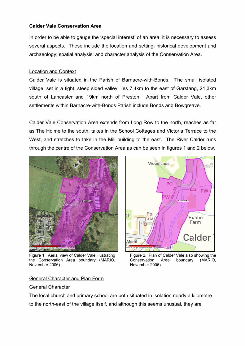
Calder Vale Conservation Area
In order to be able to gauge the ‘special interest’ of an area, it is necessary to assess
several aspects. These include the location and setting; historical development and
archaeology; spatial analysis; and character analysis of the Conservation Area.
Location and Context
Calder Vale is situated in the Parish of Barnacre-with-Bonds. The small isolated
village, set in a tight, steep sided valley, lies 7.4km to the east of Garstang, 21.3km
south of Lancaster and 19km north of Preston. Apart from Calder Vale, other
settlements within Barnacre-with-Bonds Parish include Bonds and Bowgreave.
Calder Vale Conservation Area extends from Long Row to the north, reaches as far
as The Holme to the south, takes in the School Cottages and Victoria Terrace to the
West, and stretches to take in the Mill building to the east. The River Calder runs
through the centre of the Conservation Area as can be seen in figures 1 and 2 below.
Figure 1. Aerial view of Calder Vale illustrating the Conservation Area boundary (MARIO, November 2006)
Figure 2. Plan of Calder Vale also showing the Conservation Area boundary (MARIO, November 2006)
General Character and Plan Form
General Character
The local church and primary school are both situated in isolation nearly a kilometre
to the north-east of the village itself, and although this seems unusual, they are

situated where they are for the specific reason of being able to serve both Calder
Vale and Oakenclough villages.
Plan Form
Calder Vale village takes on a linear form, with the majority of properties dispersed
along the principal street, Calder Vale Road, which runs north-east to south-west.
There is only one way into Calder Vale along Calder Vale Road, shown by a red line
in figure 4. This splits firstly to the west onto Burnside Avenue, yellow (bottom left-
hand corner); then to the south onto Albert Terrace and The Holme, green; and then
finally merges into Long Row, to the north, shown in blue.
Figure 3. Street plan of Calder Vale Conservation Area illustrating the boundary (MARIO, November 2006)
Figure 4. Plan of Calder Vale Conservation Area boundary with main traffic routes (MARIO, November 2006)
Landscape Setting
Either side of the River Calder (easterly and westerly), which runs centrally through
the Conservation Area, the land slopes steeply up and away from the water. Views
to the north-east especially are limited by rising topography, at the top of which sit the
local church and primary school.
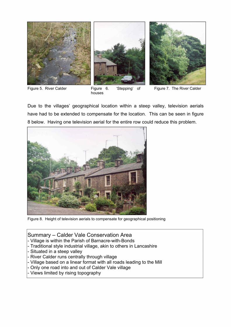
Figure 5. River Calder Figure 6. ‘Stepping’ of
houses Figure 7. The River Calder
Due to the villages’ geographical location within a steep valley, television aerials
have had to be extended to compensate for the location. This can be seen in figure
8 below. Having one television aerial for the entire row could reduce this problem.
Figure 8. Height of television aerials to compensate for geographical positioning
Summary – Calder Vale Conservation Area - Village is within the Parish of Barnacre-with-Bonds - Traditional style industrial village, akin to others in Lancashire - Situated in a steep valley - River Calder runs centrally through village - Village based on a linear format with all roads leading to the Mill - Only one road into and out of Calder Vale village - Views limited by rising topography

2. Community Involvement
Community involvement has been the key to the process of undertaking a
Conservation Area Appraisal and Management Plan. It was considered essential to
engage the local community in evaluating what they consider to make the area of
‘special’ significance. As such, the local primary school was encouraged to become
involved in the process, with the children embarking on their own project. This
project involved the children taking photographs of parts of the village that they
considered being of ‘special’ interest, plus the areas they considered to spoil the
village. The children then presented their findings, in June 2006, to members of the
local community.
The Community were then given the opportunity to walk around the village with
officers from Lancashire County Council and Wyre Borough Council. They discussed
various elements of the Conservation Area and put forward their views. A survey
containing the sorts of objectives due to be included in the Management Plan was
then distributed within the local community to gain the opinions of the adults within
the village. This is contained within the appendix section of this Appraisal and
Management Plan.
The following questions were asked within the survey:
1. Do you think that an Article 4(2) Direction would be beneficial in Calder Vale
Conservation Area? The community responded by saying would like to see the
adoption of Article 4(2) Directions to:
• Prevent further deterioration in character and to promote the future
reinstallation of timber sash windows;
• Allow restoration of original windows / doors;
• Stop the alteration of private gardens, stone walls and gate posts, but to still
keep the individuality of each building;
• Stop buildings being painted inappropriate colours.
2. Would you like to see any new Tree Preservation Orders (TPOs) made in Calder
Vale? Specifically which tree(s)? The general consensus from the community

detailed that more TPOs are not needed within the Conservation Area and the Tree
Officer agrees with this opinion.
3. Would you like to see planning obligations used in Calder Vale Conservation
Area? If so, what sort of enhancements would you like to see? General consensus
from the local community suggested the following enhancements would benefit the
village:
• A visitors car park;
• Children’s play area;
• Lengthsman – the roads are not suited to kerbside cleaning; and
• The replacement of the current plastic bus stop in favour of a stone alternative
more in keeping with the local materials used in the village.
The Councils’ new Local Development Framework will designate sites for a visitors’
car park and a childrens play area.
4. Do you think that Calder Vale would benefit from a Village Design Statement
(VDS)? The community as a whole did not think it was necessary for a Village
Design Statement to be compiled on Calder Vale.
5. Are there any other issues you would wish to see addressed in the Calder Vale
Conservation Area management Plan? The majority of the community also thought
the following areas should be addressed and would benefit from investment and / or
renovation:
• More public bins;
• The bus stop outside the Village Hall – graffiti on walls and constant litter
problem;
• The roads are in need of repair due to subsidence; and
• Pavements needing to be installed.
From the local community survey there were also some interesting opinions
concerning modern housing developments. Some of the residents view new housing
to be essential to the area, to bring in more children for the school, and a few believe
all plans for new development should be permitted. However, these views are for the
area as a whole and therefore the residents do not believe that new developments
are essential within the Conservation Area. It is important for all plans to be carefully
considered before granting planning permission and in particular consideration given
to whether new development will detract from what makes the Conservation Area
special. Other members of the community have the opinion that there is little land
available for any new housing developments in or near the Conservation Area.
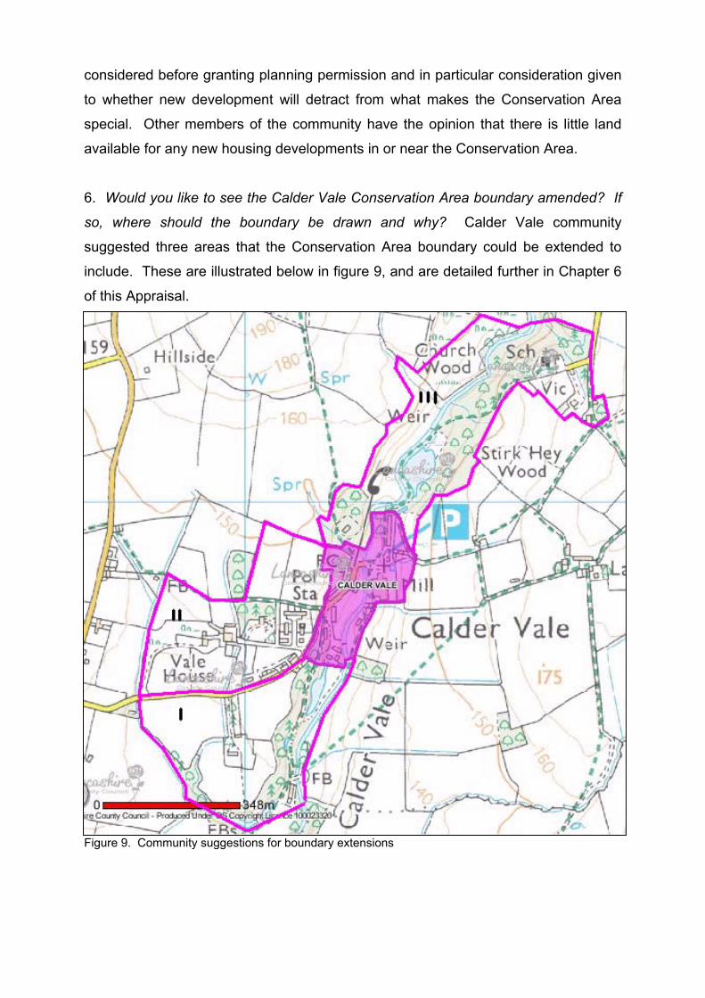
6. Would you like to see the Calder Vale Conservation Area boundary amended? If
so, where should the boundary be drawn and why? Calder Vale community
suggested three areas that the Conservation Area boundary could be extended to
include. These are illustrated below in figure 9, and are detailed further in Chapter 6
of this Appraisal.
Figure 9. Community suggestions for boundary extensions

Consultation Period Comments
The Consultation Period for Calder Vale Conservation Area Appraisal extended from
2nd April until 30th June 2007, totalling a twelve-week duration. Originally, the
Consultation Period had been intended to consist of a six-week period but due to
resident outcry this was increased. During this time, thirty written comments were
received with regard to Calder Vale Conservation Area Appraisal and Management
Plan. There were a few issues that arose. One of which was the possibility of
adopting Article 4 Directions in the future, in an attempt to retain the character of the
area through controlling the types of doors and windows that can be installed within
the Conservation Area boundary. It has since been decided that an Article 4
Direction would not be appropriate within Calder Vale, as it would have little effect on
the current properties.
Concern was also expressed as to the suggested location of a childrens play area
and public car park within the area. The suggested place to situate the play area had
been the green below Long Row, and the car park location had been unspecified.
However, as this possible situation was simply a suggestion, the location of a
childrens play area and car park has yet to be decided, but will take into
consideration the comments made when a site is being deliberated for dedication.
Another issue with the Conservation Area Appraisal was the suggestion of listing the
Lappet Mill. English Heritage have since decided that the building does not warrant
listing, in that many original features have been removed and they are of the opinion
that the building has appropriate protection by being within the Conservation Area.
Future development also became an issue; with many residents believing the
Conservation Area Appraisal was being produced to review the potential for
development in the area. There have never been plans or proposals for any
development in Calder Vale and this point has been stressed to the residents. It was
also emphasized, however, that Conservation Area status does not indicate that new
development is prevented completely; instead new development is positively
controlled. By this it is meant that the materials and design of the possible
development would be restricted to suit the surrounding character and appearance,
i.e. slate would be required for a roof material instead of a possible concrete tile, local
stone would be encouraged, etc.
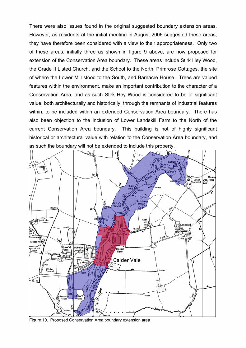
There were also issues found in the original suggested boundary extension areas.
However, as residents at the initial meeting in August 2006 suggested these areas,
they have therefore been considered with a view to their appropriateness. Only two
of these areas, initially three as shown in figure 9 above, are now proposed for
extension of the Conservation Area boundary. These areas include Stirk Hey Wood,
the Grade II Listed Church, and the School to the North; Primrose Cottages, the site
of where the Lower Mill stood to the South, and Barnacre House. Trees are valued
features within the environment, make an important contribution to the character of a
Conservation Area, and as such Stirk Hey Wood is considered to be of significant
value, both architecturally and historically, through the remnants of industrial features
within, to be included within an extended Conservation Area boundary. There has
also been objection to the inclusion of Lower Landskill Farm to the North of the
current Conservation Area boundary. This building is not of highly significant
historical or architectural value with relation to the Conservation Area boundary, and
as such the boundary will not be extended to include this property.
Figure 10. Proposed Conservation Area boundary extension area
3. Historical Development
Calder Vale was largely formed in the 19th Century by the John Jackson and his
family, through the construction of a mill, and it was there that the name was created
(Bilsborough, N., 1989). The idea was to improve the already existing industrial
potential found at Oakenclough, therefore developing into the site that is now Calder
Vale.
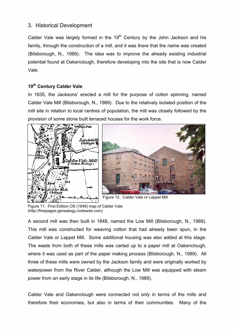
19th Century Calder Vale In 1835, the Jacksons’ erected a mill for the purpose of cotton spinning, named
Calder Vale Mill (Bilsborough, N., 1989). Due to the relatively isolated position of the
mill site in relation to local centres of population, the mill was closely followed by the
provision of some stone built terraced houses for the work force.
Figure 12. Calder Vale or Lappet Mill
Figure 11. First Edition OS (1846) map of Calder Vale (http://freepages.genealogy.rootsweb.com) A second mill was then built in 1848, named the Low Mill (Bilsborough, N., 1989).
This mill was constructed for weaving cotton that had already been spun, in the
Calder Vale or Lappet Mill. Some additional housing was also added at this stage.
The waste from both of these mills was carted up to a paper mill at Oakenclough,
where it was used as part of the paper making process (Bilsborough, N., 1989). All
three of these mills were owned by the Jackson family and were originally worked by
waterpower from the River Calder, although the Low Mill was equipped with steam
power from an early stage in its life (Bilsborough, N., 1989).
Calder Vale and Oakenclough were connected not only in terms of the mills and
therefore their economies, but also in terms of their communities. Many of the
people that resided in one village, were often employed in the other. Research into
census records revealed that the majority of people in Calder Vale during the mid-
19th Century originated from the Lancashire Plain, and especially from the Over Wyre
area of the Fylde (Bilsborough, N., 1989).
The people, who came to work in Calder Vale and Oakenclough, were generally not
from an industrial background, but agricultural families (Bilsborough, N., 1989). This
is evident from the care and attention that these people put into tending their
gardens.
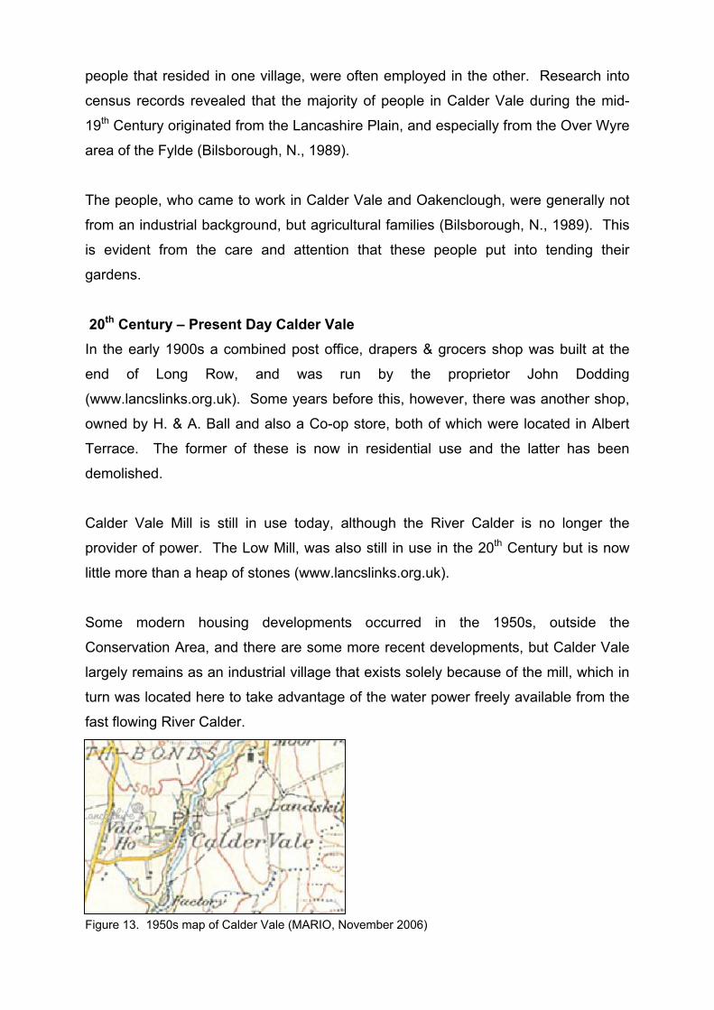
20th Century – Present Day Calder Vale In the early 1900s a combined post office, drapers & grocers shop was built at the
end of Long Row, and was run by the proprietor John Dodding
(www.lancslinks.org.uk). Some years before this, however, there was another shop,
owned by H. & A. Ball and also a Co-op store, both of which were located in Albert
Terrace. The former of these is now in residential use and the latter has been
demolished.
Calder Vale Mill is still in use today, although the River Calder is no longer the
provider of power. The Low Mill, was also still in use in the 20th Century but is now
little more than a heap of stones (www.lancslinks.org.uk).
Some modern housing developments occurred in the 1950s, outside the
Conservation Area, and there are some more recent developments, but Calder Vale
largely remains as an industrial village that exists solely because of the mill, which in
turn was located here to take advantage of the water power freely available from the
fast flowing River Calder.
Figure 13. 1950s map of Calder Vale (MARIO, November 2006)

4. Character Appraisal
The village was created purely as a means of accommodating workers from the
cotton mill. Everything is therefore within close reach of the mill. The houses are
simple, very functional buildings, constructed of local stone and slate roofs,
originating at the mill and aligning with the contours of the steeply graded valley
location. The style of the houses is akin to other industrial towns in Lancashire, built
by mill or factory owners for their workforces.
Topography, Views and Vistas Due to the steepness of the v-shaped valley, plus the high abundance of trees, long
distance views are extremely limited, both into and out of the village plus internally.
Trees heavily dominate the views into and within the Conservation Area, which in
turn illustrates the linear pattern of the settlement.
Figure 14. Victoria Terrace – housing for the employees of the mill
Figure 15. Lower Terrace – employee housing showing the abundance of trees
Figure 16. Albert Terrace Figure 17. Village Hall Figure 18. Mount Pleasant

Figure 19. Long Row Terrace Figure 20. View up Victoria Terrace
Summary – Topography, Views and Vistas - Attractive valley, with steep sloping sides - Rows of terraced houses, manipulated to fit into the valley - Views heavily dominated by trees - Linear pattern of settlement, with all roads leading to the Mill
Activity and Former Uses The construction of the Cotton Mill in the 1835, led to the arrival of many workmen
and in order to keep this work force in the area, housing was designed and provided
within the village. These stone built terraced houses followed closely after the
construction of the cotton mill. The cotton mill created these buildings, and in turn
the buildings created the village, therefore fundamentally manipulating the plan of the
current village, and also accentuating the linear form.
The area within the Conservation Area is almost entirely used for residential purpose,
with only one shop, combined with a post office, the Mill, the Village Hall and a
Church existing for other than residential use within the village. The traditional village
of Calder Vale incorporated within the Conservation Area boundary does not have a
public house, as the Mill owner didn’t want the workers to be intoxicated at work.
However, there is now a Social Club that does serve alcohol, but this is situated
outside the Conservation Area.
Summary – Activity and Former Uses - Predominantly residential and always has been - One combined Post Office and shop, a Mill, the Village Hall and one Church
Buildings The old rows of terraced cottages, built for the workmen of the Cotton Mill, are mainly
two-storey and follow the curve of the streets, giving a sense of enclosure and
guiding the eye down towards the River Calder. These cottages give Calder Vale
their character as they help give the impression of a rural industrial village.
Mount Pleasant is a good example of the accommodation given to the Mill managers
and their families as these semi-detached houses were built solely for this purpose.
This helps show the social divide in industrial society, between the Cotton Mill
managers and the workers.
There are two churches within the area, which is fairly unusual due to the small
collection of housing and the relatively small village population. However, as each
church covers a different religion (Methodist and Church of England), it allows
choice of faith within the community. Only the Methodist Church is situated within
the Conservation Area boundary. This is situated close to the Mill building and may
have been a strategic move on the part of the Mill owners, as they would have
wanted a temperance village.
Listed Buildings
Within the Conservation Area of Calder Vale, there are two listed buildings
(www.imagesofengland.org.uk). These consist of: Numbers 1 and 2 Mount Pleasant
and Calder Vale Bridge. Full Listed Building descriptions can be found in the
appendix section of this Conservation Area Appraisal and Management Plan.
• Numbers 1 and 2 Mount Pleasant
These semi-detached houses were listed at Grade II on 9th January 1986. They
were specifically built for the mill managers and their families in the early to mid 19th
Century. They are constructed of sandstone with slate roofs. They are two-storey,
with three bays. Number 1, at the left, is of one bay with the door to the right, and
has sash windows with glazing bars and plain stone surrounds. The door has a
plain stone surround and has a fanlight. Number 2 consists of the further two bays,
with its door in the left hand bay (central to the building as a whole). There is a
toothed joint that suggests the right bay is an addition. This toothed joint is where
hollows are left in a brick or stone wall in order to receive another wall intended to be
built at a later date (www.trp.dundee.ac.uk/research/glossary/glossary.html).
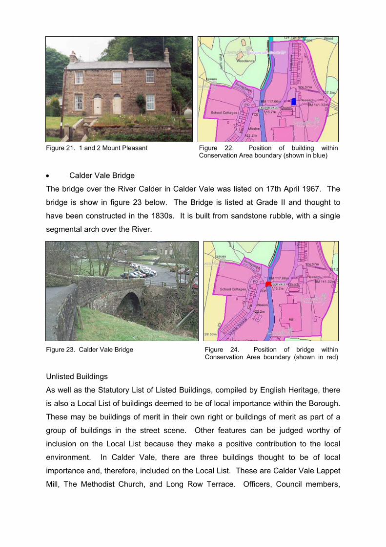
Figure 21. 1 and 2 Mount Pleasant Figure 22. Position of building within
Conservation Area boundary (shown in blue)
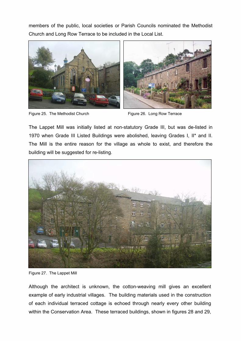
• Calder Vale Bridge
The bridge over the River Calder in Calder Vale was listed on 17th April 1967. The
bridge is show in figure 23 below. The Bridge is listed at Grade II and thought to
have been constructed in the 1830s. It is built from sandstone rubble, with a single
segmental arch over the River.
Figure 23. Calder Vale Bridge Figure 24. Position of bridge within
Conservation Area boundary (shown in red)
Unlisted Buildings
As well as the Statutory List of Listed Buildings, compiled by English Heritage, there
is also a Local List of buildings deemed to be of local importance within the Borough.
These may be buildings of merit in their own right or buildings of merit as part of a
group of buildings in the street scene. Other features can be judged worthy of
inclusion on the Local List because they make a positive contribution to the local
environment. In Calder Vale, there are three buildings thought to be of local
importance and, therefore, included on the Local List. These are Calder Vale Lappet
Mill, The Methodist Church, and Long Row Terrace. Officers, Council members,
members of the public, local societies or Parish Councils nominated the Methodist
Church and Long Row Terrace to be included in the Local List.
Figure 25. The Methodist Church Figure 26. Long Row Terrace
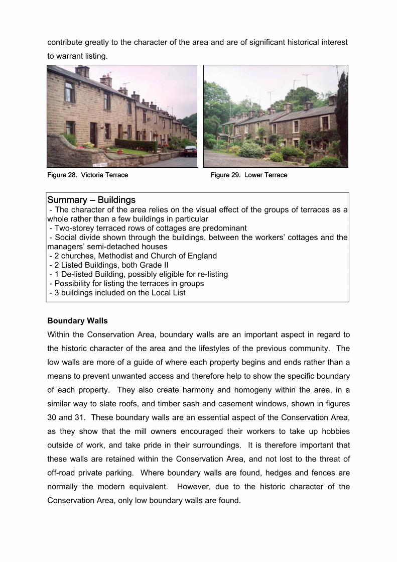
The Lappet Mill was initially listed at non-statutory Grade III, but was de-listed in
1970 when Grade III Listed Buildings were abolished, leaving Grades I, II* and II.
The Mill is the entire reason for the village as whole to exist, and therefore the
building will be suggested for re-listing.
Figure 27. The Lappet Mill
Although the architect is unknown, the cotton-weaving mill gives an excellent
example of early industrial villages. The building materials used in the construction
of each individual terraced cottage is echoed through nearly every other building
within the Conservation Area. These terraced buildings, shown in figures 28 and 29,
contribute greatly to the character of the area and are of significant historical interest
to warrant listing.
Figure 28. Victoria Terrace Figure 28. Victoria Terrace Figure 29. Lower Terrace Figure 29. Lower Terrace
Summary – Buildings Summary – Buildings - The character of the area relies on the visual effect of the groups of terraces as a whole rather than a few buildings in particular - Two-storey terraced rows of cottages are predominant - Social divide shown through the buildings, between the workers’ cottages and the managers’ semi-detached houses - 2 churches, Methodist and Church of England - 2 Listed Buildings, both Grade II - 1 De-listed Building, possibly eligible for re-listing - Possibility for listing the terraces in groups - 3 buildings included on the Local List
Boundary Walls
Within the Conservation Area, boundary walls are an important aspect in regard to
the historic character of the area and the lifestyles of the previous community. The
low walls are more of a guide of where each property begins and ends rather than a
means to prevent unwanted access and therefore help to show the specific boundary
of each property. They also create harmony and homogeny within the area, in a
similar way to slate roofs, and timber sash and casement windows, shown in figures
30 and 31. These boundary walls are an essential aspect of the Conservation Area,
as they show that the mill owners encouraged their workers to take up hobbies
outside of work, and take pride in their surroundings. It is therefore important that
these walls are retained within the Conservation Area, and not lost to the threat of
off-road private parking. Where boundary walls are found, hedges and fences are
normally the modern equivalent. However, due to the historic character of the
Conservation Area, only low boundary walls are found.

Figure 30. Boundary Walls Figure 31. Boundary Walls
Summary – Boundary Walls - Low walls, consisting of local sandstone generally with timber gates - Create harmony and homogeny in area
Public Realm Audit Within a Conservation Area, all street furniture should be as near the original as
possible, with the condition that it still fulfils the needed function for modern
requirements. Street furniture should also be in relatively similar styles. For
example, if there were five different styles of lighting within an area, it would detract
from the character, as it complicates the aesthetic view. This issue is the same for all
other aspects of street furniture.
Street Lighting
Within Calder Vale Conservation Area lighting appears to take on the same form for
the most part. The only variation, show in figures 36 and 37, takes on a slightly
altered design, being slightly more pointed above the actual light fitting. While this
discrepancy is on a small scale, and although there is consistency between the
lighting columns, the overall style is inappropriate for Calder Vale Conservation Area
and a traditional design would be more suitable.
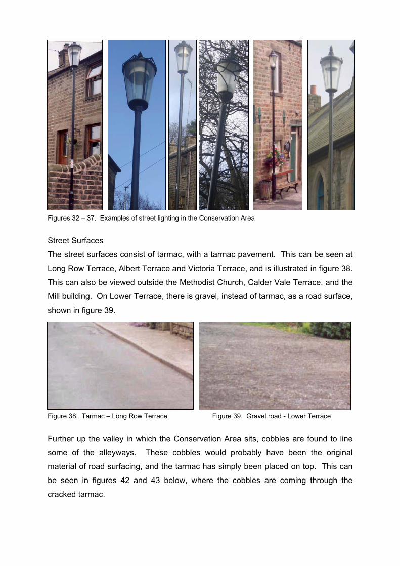
Figures 32 – 37. Examples of street lighting in the Conservation Area
Street Surfaces The street surfaces consist of tarmac, with a tarmac pavement. This can be seen at
Long Row Terrace, Albert Terrace and Victoria Terrace, and is illustrated in figure 38.
This can also be viewed outside the Methodist Church, Calder Vale Terrace, and the
Mill building. On Lower Terrace, there is gravel, instead of tarmac, as a road surface,
shown in figure 39.
Figure 38. Tarmac – Long Row Terrace Figure 39. Gravel road - Lower Terrace
Further up the valley in which the Conservation Area sits, cobbles are found to line
some of the alleyways. These cobbles would probably have been the original
material of road surfacing, and the tarmac has simply been placed on top. This can
be seen in figures 42 and 43 below, where the cobbles are coming through the
cracked tarmac.
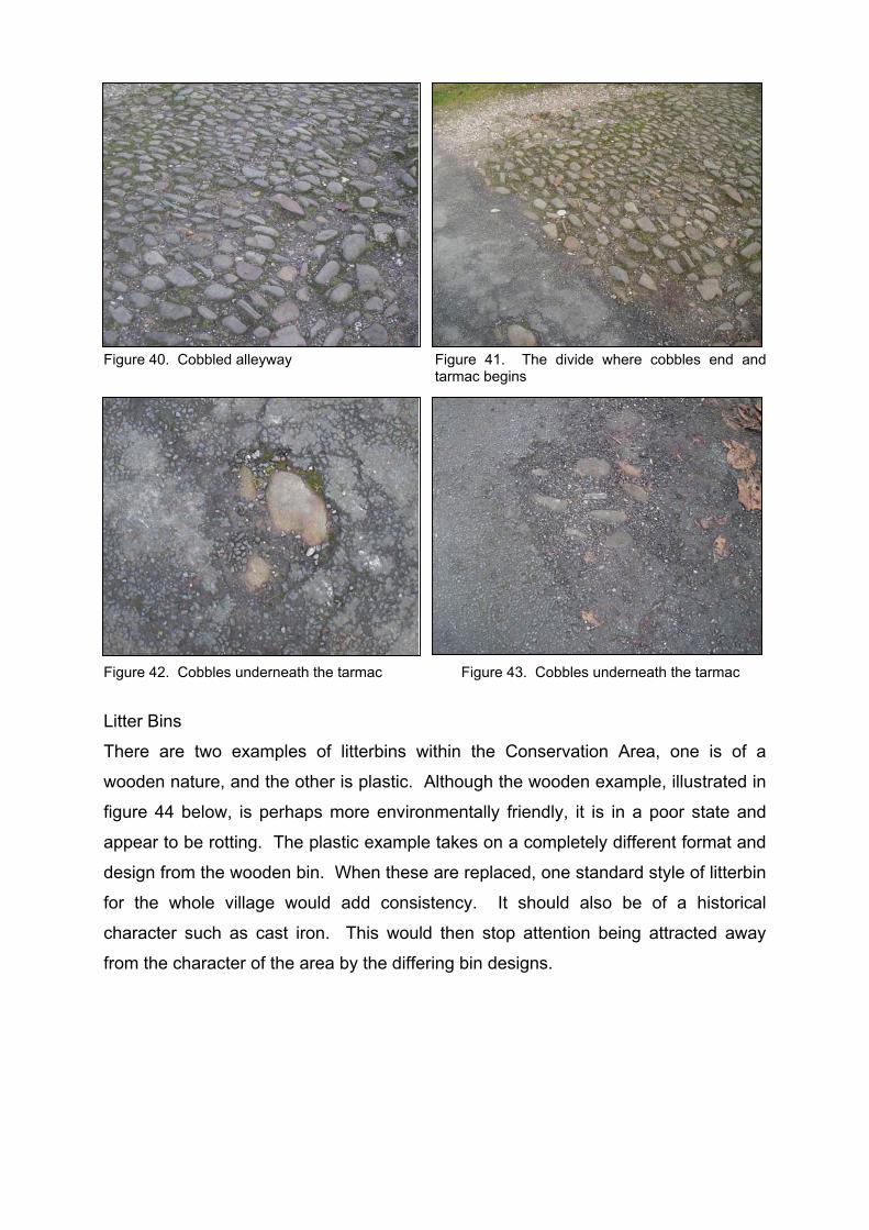
Figure 40. Cobbled alleyway Figure 41. The divide where cobbles end and tarmac begins
Figure 42. Cobbles underneath the tarmac Figure 43. Cobbles underneath the tarmac
Litter Bins
There are two examples of litterbins within the Conservation Area, one is of a
wooden nature, and the other is plastic. Although the wooden example, illustrated in
figure 44 below, is perhaps more environmentally friendly, it is in a poor state and
appear to be rotting. The plastic example takes on a completely different format and
design from the wooden bin. When these are replaced, one standard style of litterbin
for the whole village would add consistency. It should also be of a historical
character such as cast iron. This would then stop attention being attracted away
from the character of the area by the differing bin designs.

Figure 44. Current wooden litterbin design Figure 45. Current plastic bin design
Signage
Calder Vale village contains two examples of property signage. The first is the fascia
sign for the Post Office building. This is a large modern sign constructed of plastic
with a modern text font. The colours used within the fascia are appropriate to the
area. It would possibly be more in keeping with the area to reduce the size of the
fascia sign and have a more traditional style hand painted font. The second example
of signage is another fascia sign advertising the location of the Village Hall. Again
traditional colours are used, but this time it is constructed of timber, the font is raised
and is therefore more appropriate in historical terms.
Figure 46. Post Office fascia signage Figure 47. Village Hall signage
Benches
There are two examples of benches within Calder Vale Conservation Area. These
are both situated on Long Row. One of these benches, illustrated in figure 48 below,
currently has no back. The other example looks new however, and could possibly be
a replacement bench for the broken one. There are other benches within the area
but these are situated within private gardens.

Figure 48. Broken bench Figure 49. New bench – possibly a replacement
Public Telephone Boxes
There is an only one public telephone box within Calder Vale village, and it takes the
form of the traditional K6 red phone box that has been prevalent from its creation in
1924. This helps to create the rural image of the village and listing should be
considered.
Figure 50. Calder Vale public telephone box
Summary – Public Realm Audit - Similar style of street lighting throughout Conservation Area but not an entirely suitable design - Road surfaces are mainly tarmac but there are some areas where cobbles are visible through cracked tarmac, and one area where cobbles have been kept - Two designs of litterbins in the Conservation Area, both needing replaced in favour of one style - Appropriate colours for the area are used in the two examples of signage but the fascia size, letter style and material is too modern at the Post Office - The benches are of suitable design but one is badly in need of repair, currently having no back - An original red traditional telephone box, a suggestion for listing

Open Space and Footpaths Within the Conservation Area, there are quite a few areas of open green space. This
helps to give the village of Calder Vale its rural character. The amount of open space
is also unusual in comparison to modern day industrial towns and villages where
green open land is rare. This helps to illustrate the historical aspect of the industrial
past of Lancashire that Calder Vale makes, and therefore shows the contribution
green open spaces make to the character and appearance of the village and
Conservation Area. These open spaces are intrinsic to the character of the village
and should be protected from future development.
Figure 51. Green space on the opposite side of the River Calder from the Mill
Figure 52. Green space opposite the Mill and the Church – with two sheep grazing!
There are four footpaths within the village, advertised on directional signage within
Calder Vale Conservation Area. These are shown below and take on the form of
wooden posts with directional information for local walks. The timber signage
contributes to the rural character of the village.
Figure 53 - 56. Examples of directional signage
Summary – Open Space and Footpaths - Significant areas of open space on either side of the River Calder, both owned by the Mill - Front gardens and garden walls are important to the character of the Conservation Area - Four public footpaths
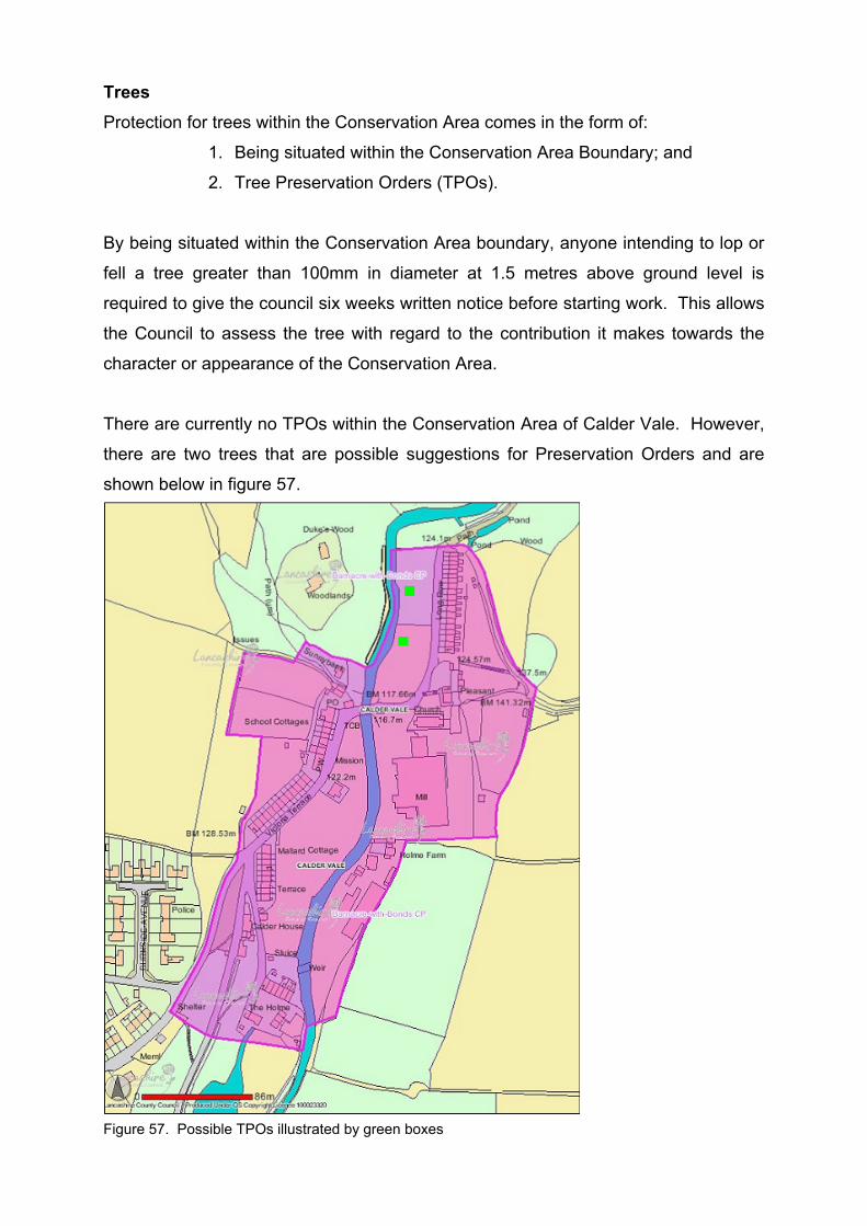
Trees Protection for trees within the Conservation Area comes in the form of:
1. Being situated within the Conservation Area Boundary; and
2. Tree Preservation Orders (TPOs).
By being situated within the Conservation Area boundary, anyone intending to lop or
fell a tree greater than 100mm in diameter at 1.5 metres above ground level is
required to give the council six weeks written notice before starting work. This allows
the Council to assess the tree with regard to the contribution it makes towards the
character or appearance of the Conservation Area.
There are currently no TPOs within the Conservation Area of Calder Vale. However,
there are two trees that are possible suggestions for Preservation Orders and are
shown below in figure 57.
Figure 57. Possible TPOs illustrated by green boxes

Architecture and Materials The materials mainly used within the Conservation Area are local stone and stone
slate roofs. Although the Methodist Church is of a later date, it has a comparable
style, and is constructed of the same materials. Because of the continuity relayed by
the group of buildings, they make a homogenous group, which is clearly why the area
was originally designated.
Figure 58. Example local stone Figure 59. Example of slate roofing
Summary – Architecture and Materials House Design - Consistency in style and rhythm - Designed to fit into steep valley surroundings - All two storeys - Majority terraced but two semi-detached properties - Local materials used in all buildings - Windows originally timber sash and casement, but few now remaining Materials for Walls and Roofs - Local sandstone is the material used in the construction of all properties within the Conservation Area - Stone slate is the predominant roofing material used within the Conservation Area - One relatively new property beside the Post Office has used slate on the roof and local stone, therefore maintaining the characteristics of the area Windows and Doorways - Originally timber painted sash and casement windows and timber painted doors but now predominantly modern uPVC glazing - Slightly recessed doorways, no porches or bay windows - Plain stone surrounds on recessed windows and doors - Fanlights on two properties

5. Pressures, Issues and Threats
Pressures The main pressures relating to the Conservation Area are:
• Future development of open space in, adjacent to, and in the valley
surrounding the Conservation Area
• The need to provide local affordable housing
• The effect of traffic and problems with parking, possibly leading to conversion
of gardens to off street parking
• The absence of a variety of local amenities
• The need to provide for tourist facilities
Issues and Threats The main threat relating to the Conservation Area is that of the ever-increasing
appearance of white uPVC windows. This can be seen in figure 60 below. These
openings have ‘landscape’ lights while the original were portrait. The original sash
also took on the form of an ‘eight over eight’ arrangement, as can be seen in figure
61, whereas the modern uPVC takes on a ‘nine over nine’ arrangement. Some
glazing has been replaced with sash and casement but the arrangements have been
lost in favour of larger panes (figure 62).
Figure 60. Modern ‘nine over nine’ arrangement uPVC window
Figure 61. Original ‘eight over eight’ arrangement sash window
Figure 62. Replacement sash and casement window

Figure 63. Modern brown uPVC Figure 64. Modern timber replacement window
Another trend within the village is the replacement of windows with brown uPVC
modern equivalents. This can be seen in figure 63 above. Although the brown uPVC
is similar in colour to wood by sight only, the end appearance is very obviously not
the same as an original or exact replacement sash and case window, and therefore
they detract from the original character of the area. Figure 64 illustrates a modern
timber replacement but the wood has been stained. Windows would traditionally
have been painted white so this further detracts from the character of the area.
Often when windows are replaced so are doors. This can be seen in figure 65 below.
Figure 66 illustrates where one of the properties on the Grade II listed Mount
Pleasant has replaced their original wooden front door, plus the fanlight above, and
sash windows, in favour of modern uPVC. The property beside retains the original
door and detailed fanlight and therefore shows what the original character should be.
Not only does this alter the character but it also disrupts the continuity of the building
as a whole. However, the property is currently under enforcement.
Figure 65. Modern uPVC door
Figure 66. Original wooden door with detail fanlight, left, modern uPVC door with plain fanlight, right (Mount Pleasant)
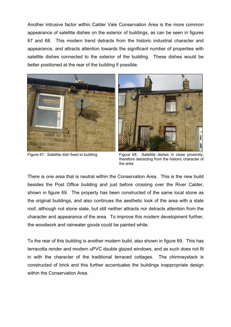
Another intrusive factor within Calder Vale Conservation Area is the more common
appearance of satellite dishes on the exterior of buildings, as can be seen in figures
67 and 68. This modern trend detracts from the historic industrial character and
appearance, and attracts attention towards the significant number of properties with
satellite dishes connected to the exterior of the building. These dishes would be
better positioned at the rear of the building if possible.
Figure 67. Satellite dish fixed to building Figure 68. Satellite dishes in close proximity, therefore detracting from the historic character of the area
There is one area that is neutral within the Conservation Area. This is the new build
besides the Post Office building and just before crossing over the River Calder,
shown in figure 69. The property has been constructed of the same local stone as
the original buildings, and also continues the aesthetic look of the area with a slate
roof, although not stone slate, but still neither attracts nor detracts attention from the
character and appearance of the area. To improve this modern development further,
the woodwork and rainwater goods could be painted white.
To the rear of this building is another modern build, also shown in figure 69. This has
terracotta render and modern uPVC double glazed windows, and as such does not fit
in with the character of the traditional terraced cottages. The chimneystack is
constructed of brick and this further accentuates the buildings inappropriate design
within the Conservation Area.

Figure 69. Modern housing within the Conservation Area
Most of the buildings are in good repair, even though modern refurbishments have
brought white and brown uPVC windows and doors and the increasing appearance
of satellite dishes on properties. The buildings are wearing well and there does not
seem to be any advanced signs of severe weathering to the stone. Only one
property is in severe disrepair. Some of the slate roofs, however, appear to be in
need of some attention as weeds are sprouting.
Figure 70. Ivy growth on slate roof
Another threat is off-road parking. Currently the only areas permitted for parking are
at the Mill and street parking outside properties. As can be seen in other areas in
Wyre Borough, front gardens are often tempting areas for property owners to convert
into private driveways. This would fundamentally affect and alter the character and
appearance of Calder Vale Conservation Area in a negative manner and therefore it
is essential that policies be constructed to prevent this from happening.
6. Opportunities, Enhancements and Improvements
Opportunities There are a number of sites that could be viewed as opportunities for the future
enhancement of the Conservation Area.
1. Two Empty Properties on Long Row
These sites offer an opportunity for restoration to occur and restore these cottages to
their former state
2. Area of green space beside the River Calder, in front of Long Row
This site has the potential for a childrens’ play area if the Mill owners are in
agreement
Recommendations for Enhancements and Improvements 1. Recent Development
This Conservation Area Appraisal will allow stronger controls within the Conservation
Area against inappropriate alterations and development. This appraisal is also
intended to be used as a guide for any future developments within the Conservation
Area, to ensure appropriateness in relation to the context.
2. Repairs and Alterations to Buildings
The aim of designating a vicinity as a Conservation Area is to attempt to preserve
and enhance the historic value. In order to do this, the following proposals are to be
implemented:
- Design Guidance and Advisory Leaflets
These will provide advice for owners and residents illustrating how the
Conservation Area affects them and their property. They will:
• Include an up-to-date map of the Conservation Area boundary,
showing where Listed Buildings are situated;
• Ensure the continued preservation and enhancement of the
character and appearance of the Conservation Area by advising
on appropriate maintenance, repairs and alterations to buildings.

3. Traffic
The increasing number of vehicles detracts from the character and appearance of the
area and also increases the risk that gardens will be converted into private
driveways. In order to prevent this from happening, a public car park would highly
benefit the area.
4. The Street Scene
The public realm within the Conservation Area would benefit from basic
enhancements, such as the provision of appropriate street lighting throughout the
area; new street furniture; and suitably sized signage. More suitable styles of
lighting, benches and bins are shown below in figures 71 – 73.
Figure 71. Proposed design of lighting (www.dwwindsor.co.uk)
Figure 72. Proposed bench style (www.streetmaster.co.uk/content/products/seats_timber).
Figure 73. Proposed design for bins (www.machanengineering.com)
Suggested Boundary Changes Through Community Involvement, the residents of Calder Vale initially suggested that
the current Conservation Area boundary be extended to include:
• The Church and Church wood (III);
• The fields surrounding the village – to protect the views surrounding the
Conservation Area and village (I, II, and III);
• The cricket field (II);
• Primrose Cottages (I);
• Low Mill Lodge (I); and
• The Upper Lodge to the north of the village (III).
All of these possible inclusions can be illustrated within three suggested boundary
extensions. The first map below illustrates the Conservation Area boundary as it

exists today, and the second map shows the Conservation Area boundary plus the
three suggested extensions, numbered I, II, and III.
Figure 74. Current Conservation Area boundary (MARIO, November 2006)
Figure 75. Proposed Conservation Area boundary changes (original map MARIO, November 2006)
The first suggested extension (I) is designed to incorporate Primrose Cottages and
the Low Mill Lodge. This would allow for a larger part of the valley to be included in
the Conservation Area and would also include areas that could be used for future
development. This area also includes the lodges that were intrinsic to the functioning
of the Mill. It would therefore be advantageous to extend the boundary as suggested
in I, as shown on the above map, figure 75.
The second suggested extension (II) proposes to include the new housing
development, evident to the west of the Conservation Area. Although this area
includes the Mill owner’s house, this majority is a modern development constructed
from modern materials, which would not benefit the character or appearance of the
existing Conservation Area. Therefore although the suggested extension represents
the modern end of development in Calder Vale over time, it would detract from the
Conservation Area rather than enhance and preserve the existing Conservation
Area.
The third suggested extension (III) proposes to include the second Church within
Calder Vale, and the woods that surround it, and the local school, as well as the

valley leading from the main body of the village to this area. The school and the
Church have always been a very important part of the village. The woodland is also
an important part of the culture of the community with bluebell walks and teas in the
village hall being held every weekend in May. However, this proposed extension
would be incorporating a very extensive area to protect the views surrounding the
village, the two buildings situated at the end, and to prevent inappropriate
development of the land. Therefore it would not be advantageous for this boundary
extension to occur.
Therefore from the areas initially suggested, it was thought that area I would be
advantageous to include. However, during the Consultation Period for this
document, information came to light, which called for a review of these proposed
areas. Since this review, there have been a number changes to the proposed
Conservation Area boundary extension area, as can be seen in figure 76 below.
These areas have been included to allow protection of the trees and views, as well
as some industrial features within Stirk Hey Wood, in addition to the Grade II Listed
Church and School to the North of the existing Conservation Area boundary. To the
South, it was thought imperative that Barnacre House be included within an extended
Conservation Area boundary, due to its past connection with the mill, and also the
site where the Lower Mill once stood, as well as Primrose Cottages.

Figure 76. Proposed Conservation Area boundary extension

Appendices

1. Full Listed Building Descriptions and Map Showing Location
• Numbers 1 and 2 Mount Pleasant “Pair of houses, early-to-mid C19. Watershot sandstone with slate roof. Two storeys, three bays. Windows sashed with glazing bars and plain stone surrounds. No. 1, at the left, is of one bay and has its door to the right. The door has a plain stone surround with round head, keystone, and impost blocks and has a fanlight. No. 2 has its door, with a similar surround, in its left-hand bay. To the right is a toothed joint, which suggests that the right-hand bay is an addition. Chimneys on gables and to left of right-hand bay. The building is mentioned in Beeden, Julia, 'The Nineteenth Century Houses of Calder Vale and Oakenclough', Contrebis 8, 1980, p.69.” • Calder Vale Bridge “Bridge over River Calder, probably 1830s. Sandstone rubble. Single segmental arch with band below parapet of rock-faced blocks.”
Map of Conservation Area showing the location of Listed Buildings: Mount Pleasant in blue, and Calder Vale Bridge in red.
2. Calder Vale Conservation Area and Management Plan Local Community Survey
Calder Vale Conservation Area Appraisal and Management Plan Calder Vale Conservation Area was designated ‘an area of special architectural or historic interest, the character or appearance of which it is desirable to preserve or enhance’ in 1974. The special character of Conservation Areas does not come from the quality of their buildings alone, but also:
• The historic layout of roads, paths and boundaries; • Characteristic building and paving materials; • The particular ‘mix’ of building uses; • Key views and vistas; • Public and private spaces such as gardens, parks and greens; • Trees; and • Street furniture.
The emphasis within Conservation Areas is on ensuring local character is strengthened, not diminished, by change. Sensitive management of change is essential since applications for planning permission must still be determined on their planning merits, following national guidance and policy. For the designation of Conservation Areas to be effective, it is important that their special qualities and local distinctiveness, as well as their value to the local community, are determined. A clear, comprehensive appraisal of the character of a Conservation Area provides a sound basis for development control and for developing initiatives to improve the area. Furthermore, where a formal Character Appraisal has been adopted by the Local Authority, it will be taken into account by the First Secretary of State in considering related planning appeals. The Character Appraisal should provide the basis for developing management proposals for the Conservation Area. The proposals should take the form of a mid- to long-term strategy, setting objectives for addressing the issues and recommendations for action arising from the appraisal. Government guidance states that a distinction should be made between the Appraisal and Management Plan, though they may form part of the same document. The sorts of objectives which we are considering for inclusion in the management plan are set out below. We would value your opinions on them.

1) Do you think that an article 4(2) direction would be beneficial in Calder Vale
Conservation Area? An Article 4(2) Direction is used to withdraw permitted development rights for a prescribed range of development which materially affects aspects of the external appearance of dwelling houses in Conservation Areas. This would mean that planning permission was required for the removal or alteration of particular architectural features, such as windows, doors, chimneys and boundary walls, which are important to the character or appearance of the Conservation Area. (Please give full reasons)---------------------------------------------------------------------------------------------------------------------------------------------------------------------------------------------------------------------------------------------------------------------------------------------------------------------------------------------------------------------------------------------------------------------------------------------------------------------------------------------------------------------------------------------------------------------------------------------------------------------------------------------------------------------------------------------------------------------------------------------------------------------------------------------------------------------------------------------------------------------------------------------------------------------------------------------------------------------------------------------------------------------------------------------------------------------------------------------------------------------------------------------------------------------------------------------------------------------------------------------------------------------------------------------------------------------------------------------------------------------------------------------------------------------------------------------------------------------------------------------------------------------------------------------------------------------------------------------------------------------------------------------------------------------------------------------------------------------------------------------------------------------------------------------------------------------------------------------- 2) Would you like to see any new Tree Preservation Orders (TPOs) made in
Calder Vale? Specifically which tree(s)? A major element in the character or appearance of many Conservation Areas is the trees. All trees with a trunk diameter of 75mm measured at 1.5m above ground level within a Conservation Area are protected under section 211 of the Town and Country Planning Act 1990. Any proposed works to them will require written notification to the Council six weeks prior to beginning those works. However, a TPO can provide and extra layer of protection. Some of the Oak trees in Church Field are considered to be possibilities. --------------------------------------------------------------------------------------------------------------------------------------------------------------------------------------------------------------------------------------------------------------------------------------------------------------------------------------------------------------------------------------------------------------------------------------------------------------------------------------------------------------------------------------------------------------------------------------------------------------------------------------------------------------------------------------------------------------------------------------------------------------------------------------------------------------------------------------------------------------------------------------------------------------------------------------------------------------------------------------------------------------------------------------------------------------------------------------------------------------------------------------------------------------------------
3) Would you like to see planning obligations used in Calder Vale Conservation
Area? If so, what sort of enhancements would you like to see? Planning obligations are negotiated legal agreements between a Local Authority and a developer. They can be used to offset the impacts of new development where these cannot be satisfactorily addressed by conditions attached to the Planning Consent. These may include the need for ‘specific mitigation’ – for example, the creation of a new wildlife area or an improved children’s play area. -------------------------------------------------------------------------------------------------------------------------------------------------------------------------------------------------------------------------------------------------------------------------------------------------------------------------------------------------------------------------------------------------------------------------------------------------------------------------------------------------------------------------------------------------------------------------------------------------------------------------------------------------------------------------------------------------------------------------------------------------------------------------------------------------------------------------------------------------------------------------------------------------------------------------------------------------------------------------------------------------------------------------------------------------------------------------------------------------------------------------------------------------------------------------- -------------------------------------------------------------------------------------------------------------------------------------------------------------------------------------------------------------------------------------------------------------------------------------------------------------------------------------------------------------------------------------------------------------------------------------------------------------------- 4) Do you think that Calder Vale would benefit from a Village Design Statement
(VDS)? VDSs are set out clear and simple guidance for the design of all development in a village, based on character. It is an advisory document produced by the village community, not by the Planning Authority. It will not stop change from happening, but it can help effect how any new building fits into the village. VDSs are intended to influence the operation of the statutory Planning System, so that new development is in harmony with its setting and makes a positive contribution to the immediate environment. ----------------------------------------------------------------------------------------------------------------------------------------------------------------------------------------------------------------------------------------------------------------------------------------------------------------------------------------------------------------------------------------------------------------------------------------------------------------------------------------------------------------------------------------------------------------------------------------------------------------------------------------------------------------------------------------------------------------------------------------------------------------------------------------------------------------------------------------------------------------------------------------------------------------------------------------------------------------------------------------------------------------------------------------------------------------------------------------------------------------------------------------------------------------------------------------------------------------------------------------------------------------------------------------------------------------------------------------------------------------------------------------------------------------------------------------------------------------------------------------------------------------------------------------------------------------------------------------------------------------------------------------------

5) Are there any other issues you would wish to see addressed in the Calder
Vale Conservation Area management Plan? --------------------------------------------------------------------------------------------------------------------------------------------------------------------------------------------------------------------------------------------------------------------------------------------------------------------------------------------------------------------------------------------------------------------------------------------------------------------------------------------------------------------------------------------------------------------------------------------------------------------------------------------------------------------------------------------------------------------------------------------------------------------------------------------------------------------------------------------------------------------------------------------------------------------------------------------------------------------------------------------------------------------------------------------------------------------------------------------------------------------------------------------------------------------------------------------------------------------------------------------------------------------------------------------------------------------------------------------------------------------------------------------------------------------------------------------------------------------------------------------------------------------------------------------------------------------------------------------------------------------------------------------------------------------------------------------------------------------------------------------------------------- ----------------------------------------------------------------------------------------------------------------- 6) Would you like to see the Calder Vale Conservation Area boundary amended?
If so, where should the boundary be drawn and why? Please use attached map to illustrate this, if necessary.
Please note that inclusion within a Conservation Area does not necessarily preclude development. However, it does mean that any development must be sympathetic in terms of scale, height, massing, detailed design and quality of materials. It must be demonstrated that proposals within a Conservation Area either preserve or enhance the area. ----------------------------------------------------------------------------------------------------------------------------------------------------------------------------------------------------------------------------------------------------------------------------------------------------------------------------------------------------------------------------------------------------------------------------------------------------------------------------------------------------------------------------------------------------------------------------------------------------------------------------------------------------------------------------------------------------------------------------------------------------------------------------------------------------------------------------------------------------------------------------------------------------------------------------------------------------------------------------------------------------------------------------------------------------------------------------------------------------------------------------------------------------------------------------------------------------------------------------------------------------------------------------------------------------------------------------------------------------------------------------------------------------------------------------------------------------------------------------------------------------------------------------- Thank you for taking the time to provide us with your comments. Please return your comments by 25th August 2006 to Planning Policy and Conservation, Wyre Borough Council, Civic Centre, Breck Road, Poulton-le-Fylde, Lancashire FY6 7PU

3. Current Aerial photos of Calder Vale (Lancashire County Council), one illustrating the village on its own and one showing the location of the Conservation Area

4. Bibliography Websites
• mario.lancashire.gov.uk/viewer.htm?categ=countryside, November 2006 • www.lancslinks.org.uk, November 2006 • www.imagesofengland.org.uk, November 2006
• www.dwwindsor.co.uk, March 2007
• www.streetmaster.co.uk/content/products/seats_timber, March 2007
• www.machanengineering.com, March 2007
Books
• Bilsborough, N., 1989, The Treasures of Lancashire, Manchester: North West Civic Trust
• Elrington, C. R., Pugh, R. B., 1990, The Victoria History of the Counties of
England, Oxford; New York: Published for the Institute of Historical Research by Oxford University Press
• Hewitson, A., 1900, Republished 1969, Northward, SR Publishers Ltd.

Calder Vale Management Plan
WYRE BOROUGH COUNCIL
Adopted: 13th August 2007

CONTENTS 1. Management Plan 2. Legislative Background 3. Statutory Controls 4. Erosion of Character and Additional Planning Control 5. Advertisements and Signage 6. Trees 7. Setting and Views 8. The Public Realm and Enhancement 9. Monitoring and Review
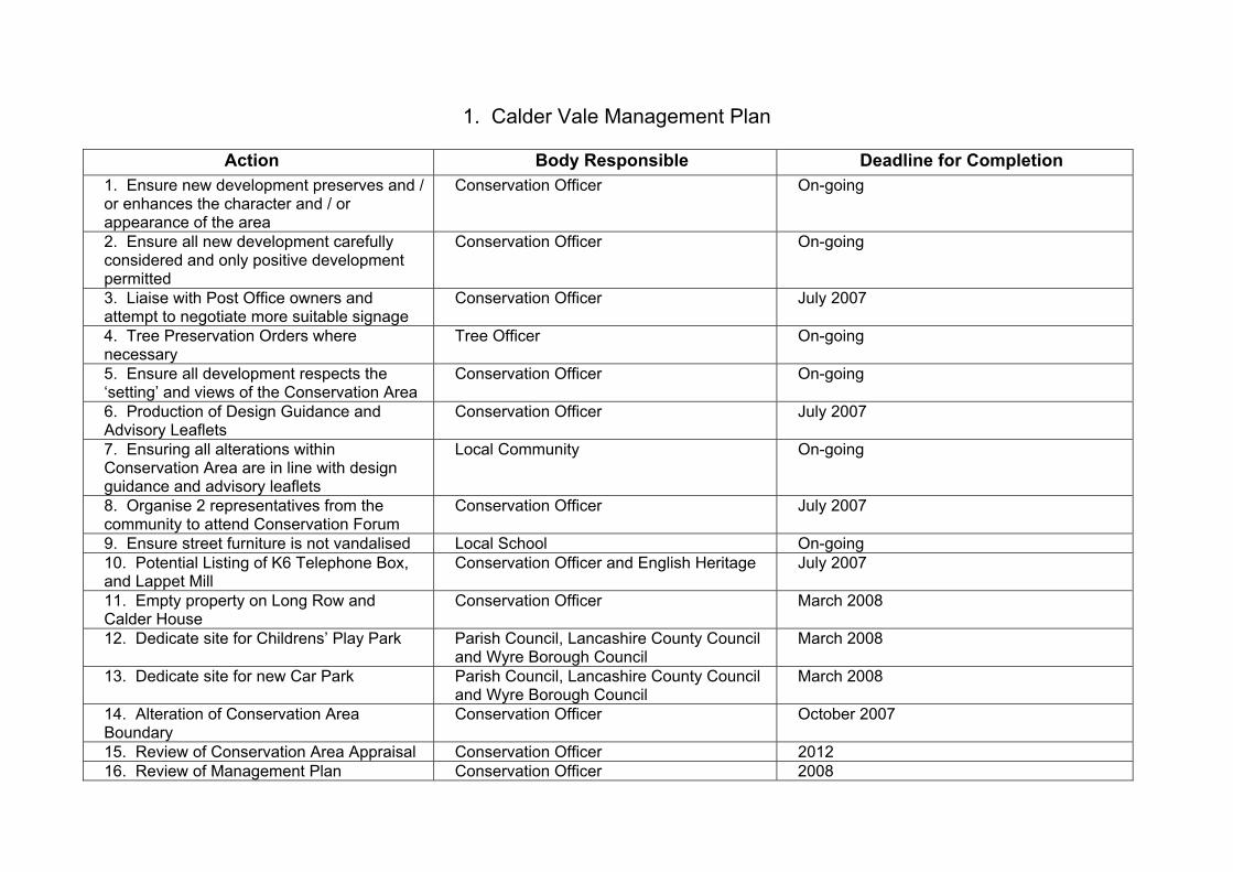
1. Calder Vale Management Plan
Action Body Responsible Deadline for Completion 1. Ensure new development preserves and / or enhances the character and / or appearance of the area
Conservation Officer On-going
2. Ensure all new development carefully considered and only positive development permitted
Conservation Officer On-going
3. Liaise with Post Office owners and attempt to negotiate more suitable signage
Conservation Officer July 2007
4. Tree Preservation Orders where necessary
Tree Officer On-going
5. Ensure all development respects the ‘setting’ and views of the Conservation Area
Conservation Officer On-going
6. Production of Design Guidance and Advisory Leaflets
Conservation Officer July 2007
7. Ensuring all alterations within Conservation Area are in line with design guidance and advisory leaflets
Local Community On-going
8. Organise 2 representatives from the community to attend Conservation Forum
Conservation Officer July 2007
9. Ensure street furniture is not vandalised Local School On-going 10. Potential Listing of K6 Telephone Box, and Lappet Mill
Conservation Officer and English Heritage July 2007
11. Empty property on Long Row and Calder House
Conservation Officer March 2008
12. Dedicate site for Childrens’ Play Park Parish Council, Lancashire County Council and Wyre Borough Council
March 2008
13. Dedicate site for new Car Park Parish Council, Lancashire County Council and Wyre Borough Council
March 2008
14. Alteration of Conservation Area Boundary
Conservation Officer October 2007
15. Review of Conservation Area Appraisal Conservation Officer 2012 16. Review of Management Plan Conservation Officer 2008
2. Legislative Background The designation of a Conservation Area and production of an Appraisal document is
not an end in itself. The Appraisal provides the basis for developing management
proposals for the Conservation Area that fulfil the general duty placed on the local
authority under the Planning (Listed Buildings and Conservation Areas) Act 1990,
now formalised in BV 219c, to draw up and publish such proposals. The purpose of
this document is to present draft proposals which seek to achieve the preservation
and enhancement of the ‘special’ character of the Conservation Area, informed by
the Appraisal, for consultation. The ‘special’ qualities of the Conservation Area have
been identified as:
• Traditional style industrial village, akin to others in Lancashire;
• Situated in a steep valley;
• River Calder runs centrally through village;
• Village based on a linear format with all roads leading to the Mill; and
• Views limited by rising topography.
These qualities have been identified within the Conservation Area Appraisal process,
and both the Appraisal and this Management Plan will be subject to monitoring and
review. This guidance draws on the themes identified in the Appraisal, and satisfies
the statutory requirement of section 71(1) of the Planning (Listed Buildings and
Conservation Areas) Act 1990, namely:
“It shall be the duty of the local planning authority from time to time to formulate and
publish proposals for the preservation and enhancement of any parts of their area
which are Conservation Areas”.
This document reflects Government guidance set out in Planning Policy Guidance 15
“Planning and the Historic Environment”, and English Heritage guidance set out in
“Guidance on the Management of Conservation Areas”.
3. Statutory Controls
Designation as a Conservation Area brings with it a degree of additional statutory
protection under planning legislation aimed at assisting the “preservation or
enhancement” of the area. These controls include the need for Conservation Area

consent for the demolition of any unlisted buildings, the need for planning consent for
the installation of satellite dishes visible from the street, significantly reduced
“permitted development rights” for alterations and extensions to dwelling houses,
restrictions on advertising, and 6 weeks written notice of works to trees not already
protected by Tree Preservation Orders.
Action 1: The Council will ensure that new development within the Conservation
Area preserves or enhances the character or appearance of the area in accordance
with the Wyre Borough Council Local Plan (1999).
4. Erosion of Character and Additional Planning Control The Conservation Area Appraisal has identified the following as works that pose a
threat to, or detract from, the ‘special’ character of the Conservation Area:
• Loss of original windows and inappropriate replacements;
• Inappropriate signage;
• Lack of continuity in individual aspects of street furniture.
There are numerous examples of works having been carried out, for example
alterations to doors and windows, which both individually and cumulatively detract
from the ‘special’ character or appearance of the area. If left, such works will
gradually erode the ‘special’ qualities that justified the original designation.
Action 1: The Council will ensure that all development will be considered and only
positive development, as defined in accordance with Wyre Borough Council’s Local
Development Framework, will be considered for planning permission in order to
further protect the ‘special’ character and historical appearance of the Conservation
Area.
Action 2: A suggestion has been made to English Heritage for the re-listing of the
Lappet Mill building and the listing of the K6 Public Telephone Box. English Heritage
have responded with the view that “although it is fitting that Lappet Mill is included in
the Calder Vale Conservation Area, the extent of alteration to the building's exterior
and interior is such that in a national context, it does not have sufficient special
architectural or historic significance to merit listing".
5. Advertisements and Signage
Signage within the Conservation Area is generally suitable apart from that of the Post
Office. The fascia is too large to be within a Conservation Area, the materials are too
contemporary, and although the colours are appropriate, the font is modern.
Therefore an attempt should be made to reduce the scale.
Action 1: The Council will liaise with the Post Office owners in an attempt to
negotiate a more suitable form of signage, in regards to size, colour and materials,
for the shopfront of the building.
6. Trees If not already protected by a Tree Preservation Order, anyone intending to lop or fell
a tree within the Conservation Area greater than 75mm in diameter at 1.5 metres
above ground level, is required to give the Council 6 weeks written notice before
starting work. This provides the Council with an opportunity of assessing the tree to
see if it makes a positive contribution to the character or appearance of the
Conservation Area, in which case a Tree Preservation Order may be served. Advice
on all tree issues, whether the pruning of existing trees or advice on suitable species
for planting, is always available from the Council Tree Officer.
Action 1: The Council will use Tree Preservation Orders wherever appropriate
where a tree of high amenity value is considered to be under threat. These will
include trees within and outside the area where they contribute to the setting of the
Conservation Area or views identified in the Appraisal.
7. Setting and Views The rural context of the Conservation Area, it’s ‘setting’, is very important, and
development which would not preserve or enhance the character or appearance of
the area or its setting, or which would impact detrimentally on views into and out of
the area will be not be permitted. The important views into and within the
Conservation Area are identified in the Character Analysis, and the Council will seek
to ensure that all new development respects these views.
Action 1: The Council will continue to ensure that all development respects the
‘setting’ of the Conservation Area, and important views within, into, and out of the
area, as identified in the Appraisal. These will be protected from inappropriate forms
of development.
8. The Public Realm and Enhancement Within the Conservation Area there should be one set design for street lighting, bins,
and benches. There should also be one specific type of paving, e.g. cobbles and
therefore where cobbles do not currently exist they should be re-instated. When the
replacement of original sash and case and modern windows occurs, an attempt
should be made to encourage the replacement of like for like. In the case of
replacement of modern windows, encouragement should be given to return to the
sash and casement window, albeit a modern wooden equivalent.
Action 1: Design guidance will be produced to encourage the traditional use of sash
and casement windows within the Conservation Area.
Action 2: The owners of the Mill will also be approached about the area of green
space beside the River Calder, in front of Long Row, which they own, about the
possibility of turning this land into a children’s play area.
9. Monitoring and Review
The following actions need to be taken to ensure that this appraisal and management
plan are accepted and acted upon:
• Public Consultation: The Appraisal and Management Plan will be subject to a
period of public consultation and views expressed as part of that process will
be considered when preparing the final draft for adoption. Consultation will
include placing the documents on the Council website, in libraries and council
offices, consultation with local amenity groups and residents associations
where they exist, and providing hard copies on request. A letter advising of
these arrangements will be delivered to all properties in the area by mail.
• Boundary review: The Council will extend the boundary of Calder Vale
Conservation Area as illustrated in the Appraisal, and continue to review it
over time in accordance with Best Practice and guidance on the management
of the historic environment produced by English Heritage.
• Document review: This management plan will be monitored on an annual
basis in the light of the Local Development Framework and emerging
government policy. A review should include the following:
(i) A survey of the Conservation Area and its boundaries
(ii) An updated “heritage count” comprising a comprehensive photographic
record.
(iii) An assessment of whether the management proposals detailed in this
document have been acted upon, including proposed enhancements.
(iv) The production of a short report detailing the findings of the survey and
proposed actions and amendments.
(v) Public consultation on the review findings, any proposed changes, and
input into the final review.
A Conservation Panel, made up of members of the Borough’s Civic and Historical
Societies, plus the Conservation Officer and Head of Planning, will also meet
quarterly to discuss any changes that have occurred or should occur within the
Conservation Area.
This Management Plan will be reviewed annually.