california coastal commission - university of...
TRANSCRIPT
STATE OF CALIFORNIA -- THE RESOURCES AGENCY ARNOLD SCHWARZENEGGER, Governor
CALIFORNIA COASTAL COMMISSION SAN DIEGO AREA
7575 METROPOLITAN DRIVE, SUITE 103
SAN DIEGO, CA 92108-4421
(619) 767-2370
W10a Filed: November 9, 2009 49th Day: December 28, 2009 180th Day: May 8, 2010 Extension Request: March 25, 2010 Length of Extension: 90 Days Final Date for Commission Action: August 6, 2010 Staff: Gabriel Buhr - SD Staff Report: May 20, 2010 Hearing Date: June 9 - 11, 2010
MATERIAL AMENDMENT STAFF REPORT AND PRELIMINARY RECOMMENDATION
Application No.: 6-04-088-A4 Applicant: Southern California Edison (SCE) Original Description: Implementation of the San Dieguito Wetland Restoration Plan,
including creation and/or restoration of approximately 165 acres of wetland habitat, dredging of the lagoon mouth to maintain an open inlet, construction of least tern nesting sites, and construction of public access trails and treatment ponds.
Proposed Amendment: Replacement of restoration module W45 with restoration module
W16, modification of the timing for the construction of public beach accessways, and modifications to the special condition regarding a riverbank revetment.
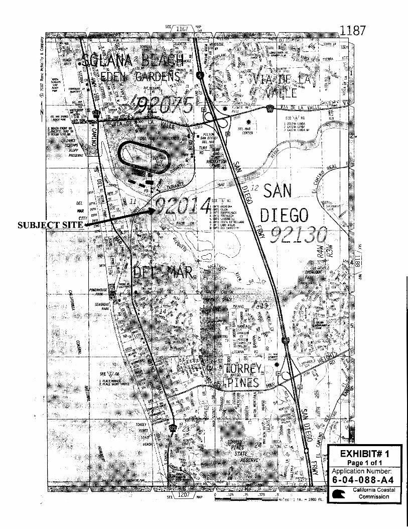
Site: Western end of San Dieguito River Valley from El Camino Real to
Pacific Ocean, with portion of trail from east of San Andres Drive to Jimmy Durante Boulevard, Del Mar and San Diego (San Diego County)
Substantive File Documents: Cities of Del Mar and San Diego certified LCPs; San Dieguito
Wetlands Restoration Project Final Restoration Plan, dated November 2005, received December 12, 2005, and revised pages iii, 2.16, 2.75, 2.93 (Figure 2.26), 4.1, 4.6 (Table 4.1), 4.8, 4.31, 4.50, 4.53, 4.71, 4.96, 5.2, 5.10, Appendix B cover sheet, and Appendix B Wetlands Impact Map dated 1/30/06, received 2/2/06, and revised page 4.7 received 2/6/06.
6-04-088-A4 (Southern California Edison) Material Amendment – Staff Report
Page 2 of 16
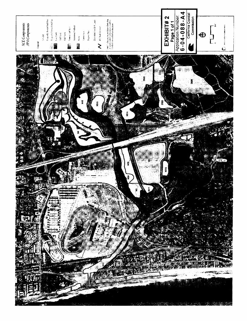
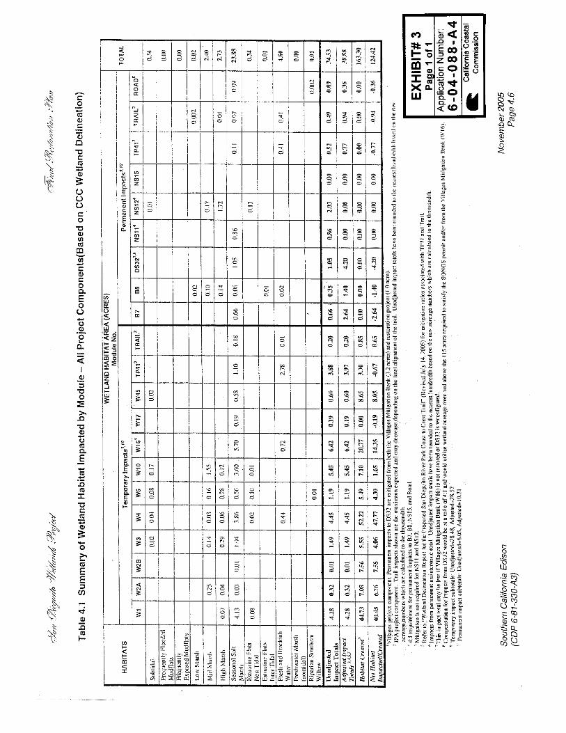
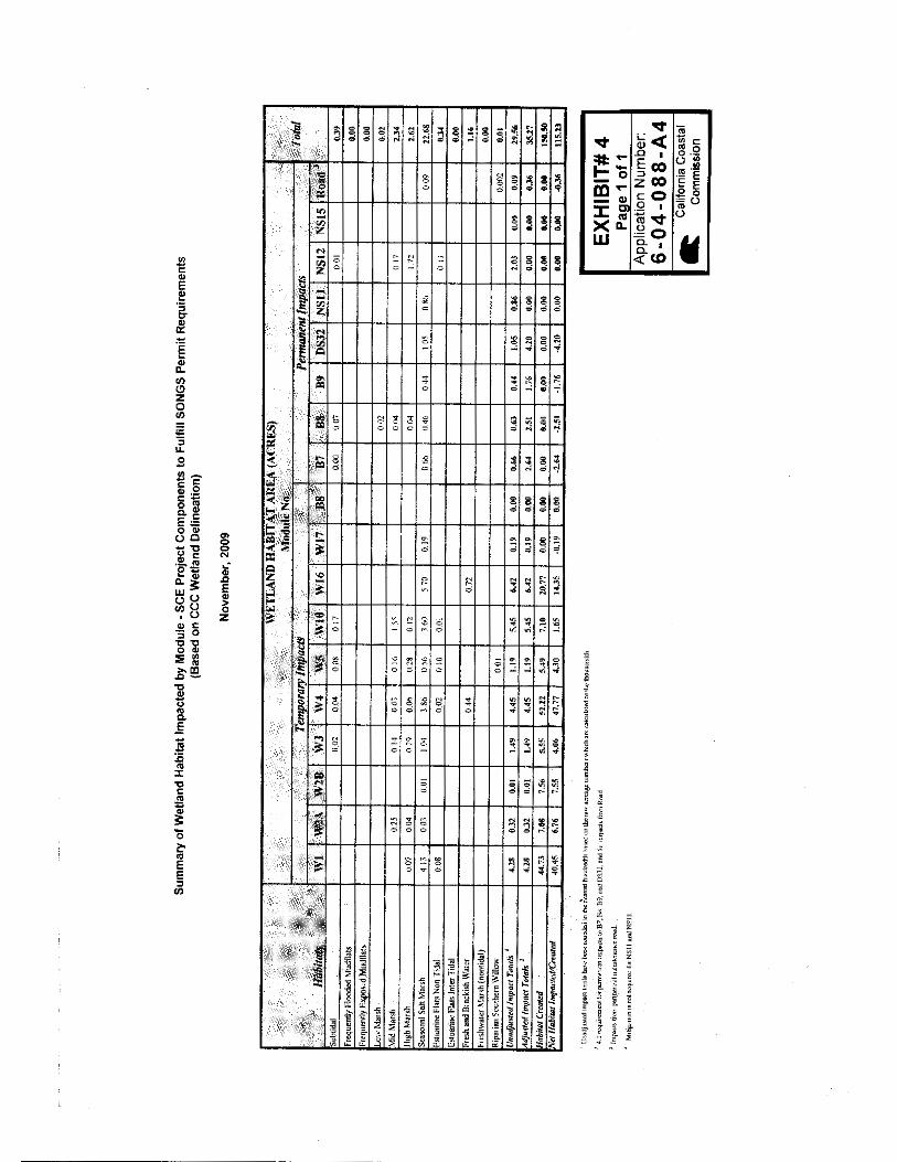
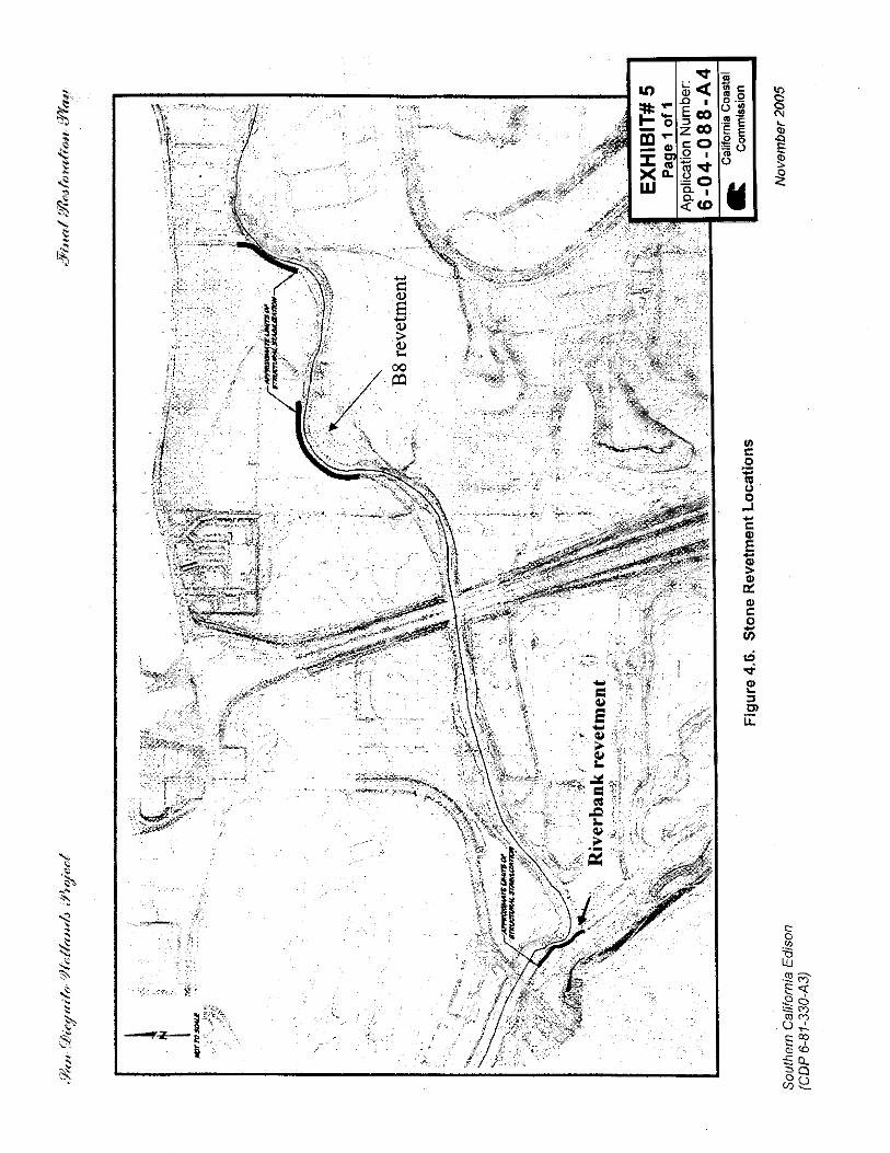
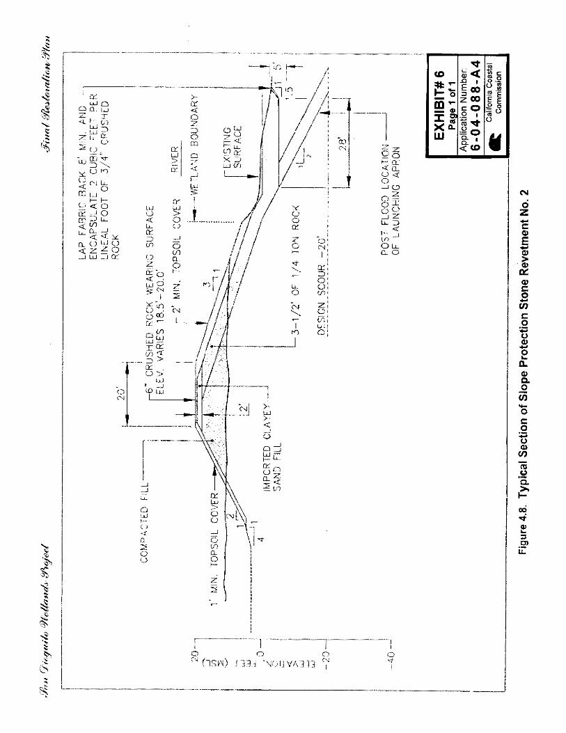
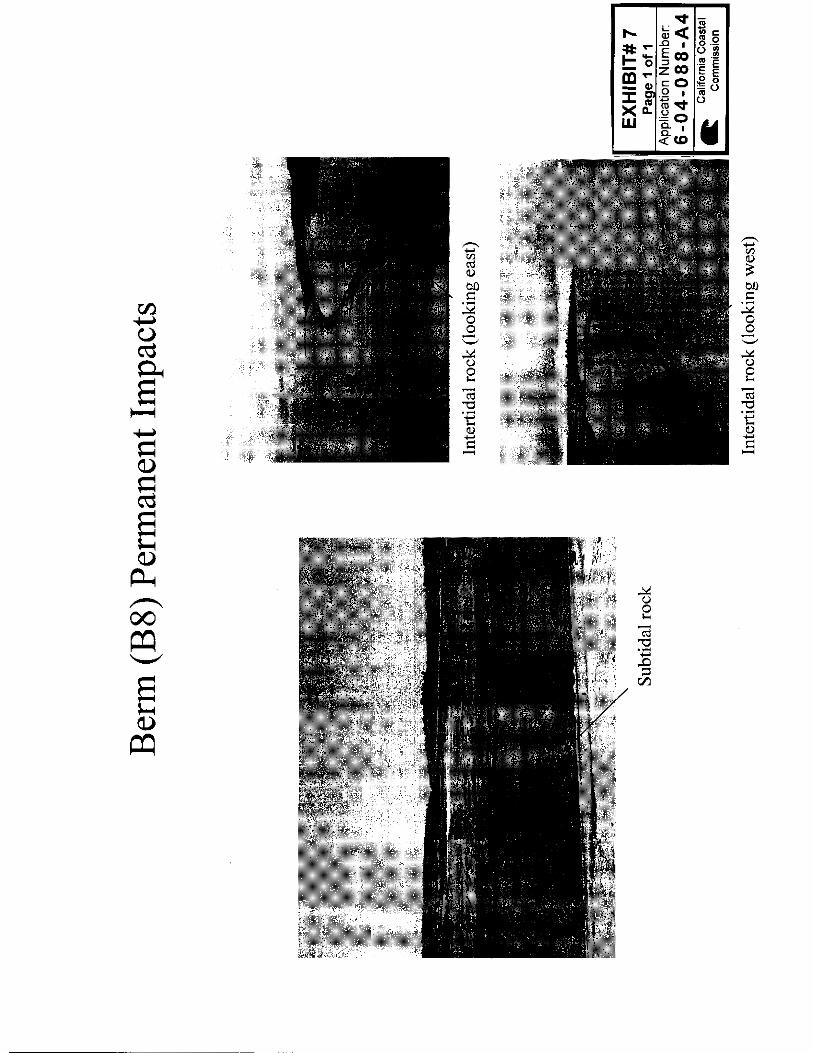
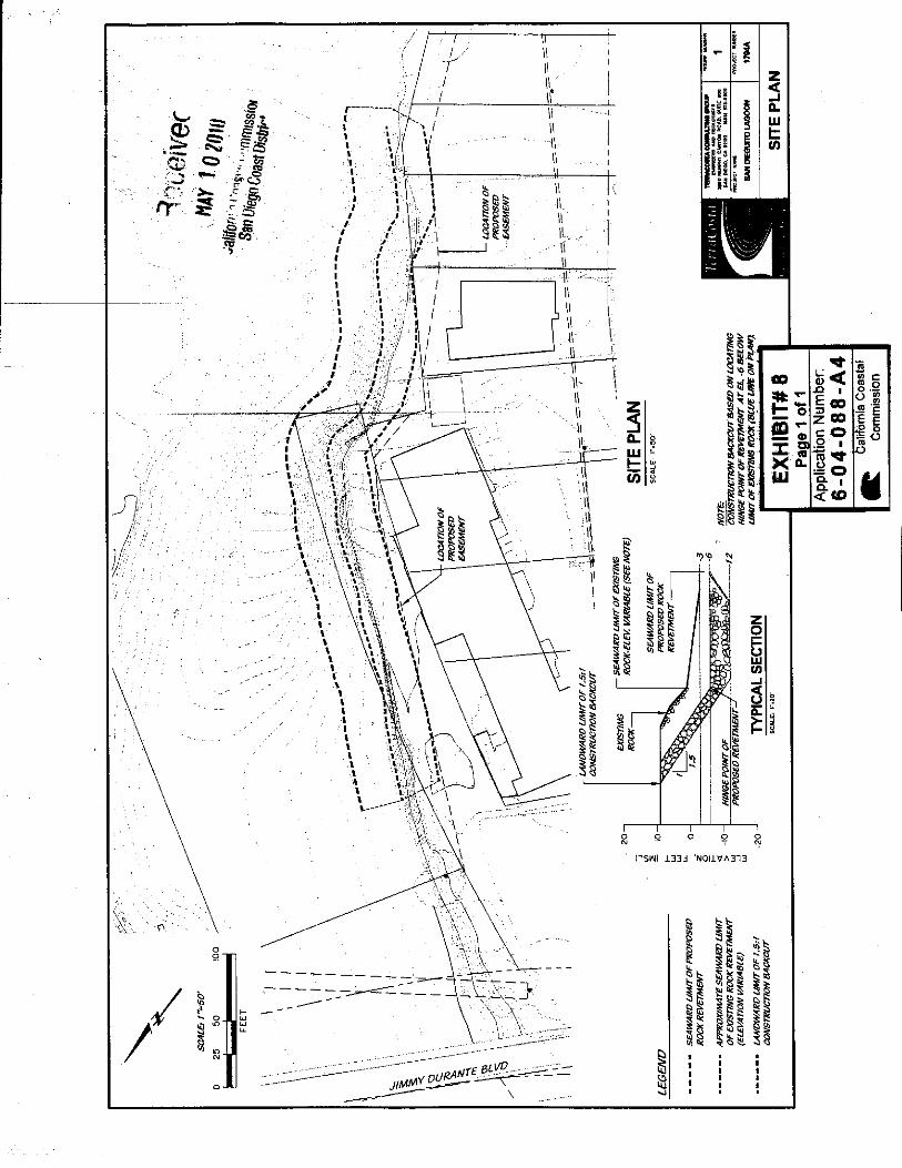
STAFF NOTES: Summary of Staff’s Preliminary Recommendation: Staff recommends approval of the proposed amendment with special conditions addressing changes to the restoration modules needed to satisfy mitigation requirements associated with the original project, a modification of the timing for the construction of two vertical public beach accessways located on either side of the lagoon inlet, and modifications to the special conditions regarding the riverbank revetment. The wetland restoration project is a requirement of Southern California Edison’s CDP #6-81-330 to mitigate the adverse impacts of the operation of the San Onofre Nuclear Generating Station Units 2 and 3 on the marine environment. A change in the previously described site conditions has warranted an alternative area be utilized as a portion of the mitigation required for the project. Slight changes to the design and location of the riverbank revetment are proposed. The need to provide improved public access, ensure public safety, and to satisfy the originally imposed mitigation wetland creation requirements are the primary issues raised by this proposal; these are resolved through the recommended modifications to the pertinent special conditions. The site is an area of filled tidelands, and Chapter 3 of the Coastal Act is the legal standard of review. Exhibits: 1. Regional Location Map 2. Restoration Site Plan 3. Habitat Impact Summary Table (original) 4. Habitat Impact Summary Table (proposed) 5. Stone Revetment Location Map (B8) 6. Stone Revetment Design Section 7. B8 Current Conditions 8. Riverbank Revetment Site Plan 9. Riverbank Revetment Current Conditions 10. Tidal Inlet Channel – Initial Grading Plan 11. Proposed Vertical Accessway – North 12. Proposed Vertical Accessway – South 13. 29th Street Existing Conditions 14. Existing Unimproved Trail at Lagoon Inlet
6-04-088-A4 (Southern California Edison) Material Amendment – Staff Report
Page 3 of 16
I. PRELIMINARY STAFF RECOMMENDATION: The staff recommends the Commission adopt the following resolution: MOTION: I move that the Commission approve the proposed amendment to
Coastal Development Permit No. 6-04-088 pursuant to the staff recommendation.
STAFF RECOMMENDATION OF APPROVAL: Staff recommends a YES vote. Passage of this motion will result in approval of the amendment as conditioned and adoption of the following resolution and findings. The motion passes only by affirmative vote of a majority of the Commissioners present. RESOLUTION TO APPROVE A PERMIT AMENDMENT: The Commission hereby approves the coastal development permit amendment on the ground that the development as amended and subject to conditions, will be in conformity with the policies of Chapter 3 of the Coastal Act and will not prejudice the ability of the local government having jurisdiction over the area to prepare a Local Coastal Program conforming to the provisions of Chapter 3. Approval of the permit amendment complies with the California Environmental Quality Act because either 1) feasible mitigation measures and/or alternatives have been incorporated to substantially lessen any significant adverse effects of the amended development on the environment, or 2) there are no feasible mitigation measures or alternatives that would substantially lessen any significant adverse impacts of the amended development on the environment. II. SPECIAL CONDITIONS The permit is subject to the following conditions (additions to the original conditions are show in underline format and removal of original language is shown in strikethrough and underline format): 1. Modify Special Condition 4 (Berm and Slope Protection) as shown:
4. Berm and Slope Protection. PRIOR TO THE COMMENCMENT OF CONSTRUCTION OF THE REVETMENT, the applicants shall submit to the Executive Director for review and written approval, final plans for berm and slope protection for the San Dieguito Wetlands Restoration Project that have been approved by the City of Del Mar and the City of San Diego. Said plans shall be in substantial conformance with the two sets of plans submitted June 20, 2005, (City of Del Mar Sheets 33-35, dated 6/17/05, and City of San Diego Sheets 67-72, dated 5/26/05), and as further detailed in the submitted site plan received May 10, 2010 attached as Exhibit 8 to this report (6-04-088-A4), and shall include the following:
6-04-088-A4 (Southern California Edison) Material Amendment – Staff Report
Page 4 of 16
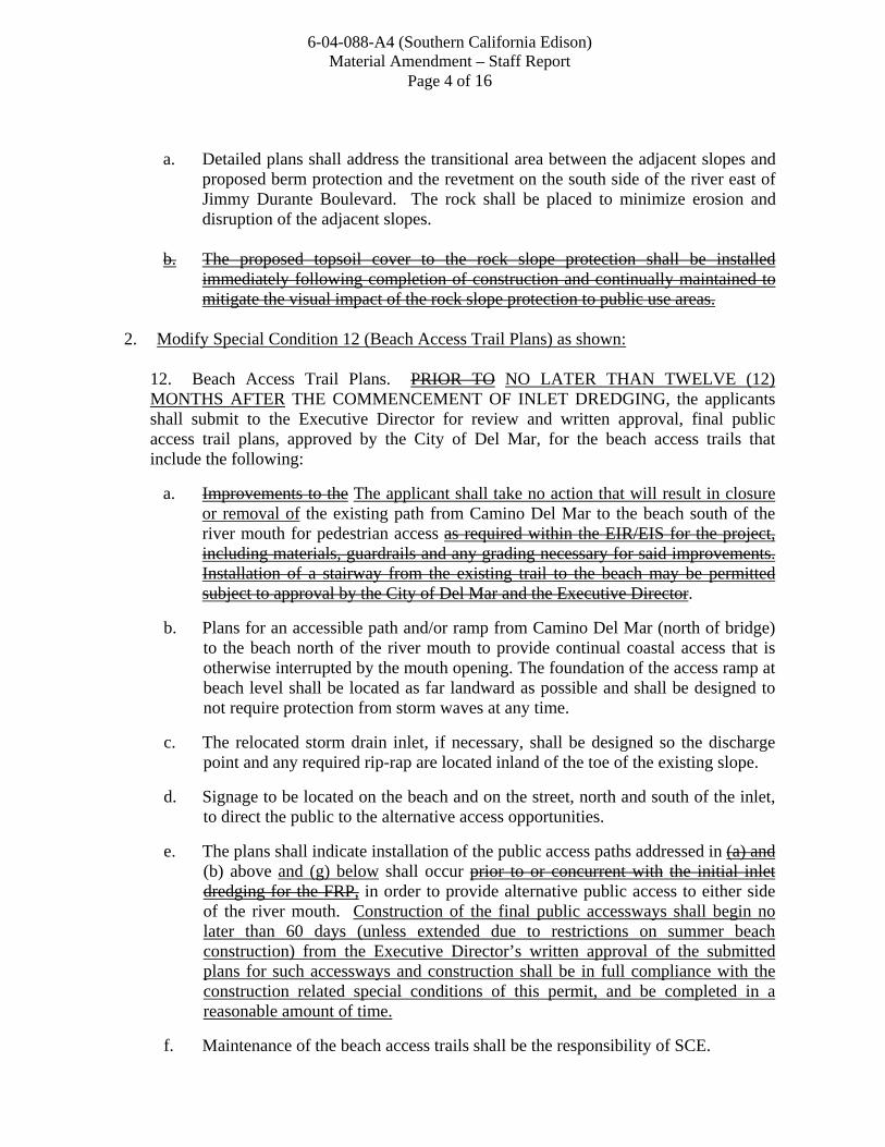
a. Detailed plans shall address the transitional area between the adjacent slopes and
proposed berm protection and the revetment on the south side of the river east of Jimmy Durante Boulevard. The rock shall be placed to minimize erosion and disruption of the adjacent slopes.
b. The proposed topsoil cover to the rock slope protection shall be installed
immediately following completion of construction and continually maintained to mitigate the visual impact of the rock slope protection to public use areas.
2. Modify Special Condition 12 (Beach Access Trail Plans) as shown:
12. Beach Access Trail Plans. PRIOR TO NO LATER THAN TWELVE (12) MONTHS AFTER THE COMMENCEMENT OF INLET DREDGING, the applicants shall submit to the Executive Director for review and written approval, final public access trail plans, approved by the City of Del Mar, for the beach access trails that include the following:
a. Improvements to the The applicant shall take no action that will result in closure or removal of the existing path from Camino Del Mar to the beach south of the river mouth for pedestrian access as required within the EIR/EIS for the project, including materials, guardrails and any grading necessary for said improvements. Installation of a stairway from the existing trail to the beach may be permitted subject to approval by the City of Del Mar and the Executive Director.
b. Plans for an accessible path and/or ramp from Camino Del Mar (north of bridge) to the beach north of the river mouth to provide continual coastal access that is otherwise interrupted by the mouth opening. The foundation of the access ramp at beach level shall be located as far landward as possible and shall be designed to not require protection from storm waves at any time.
c. The relocated storm drain inlet, if necessary, shall be designed so the discharge point and any required rip-rap are located inland of the toe of the existing slope.
d. Signage to be located on the beach and on the street, north and south of the inlet, to direct the public to the alternative access opportunities.
e. The plans shall indicate installation of the public access paths addressed in (a) and (b) above and (g) below shall occur prior to or concurrent with the initial inlet dredging for the FRP, in order to provide alternative public access to either side of the river mouth. Construction of the final public accessways shall begin no later than 60 days (unless extended due to restrictions on summer beach construction) from the Executive Director’s written approval of the submitted plans for such accessways and construction shall be in full compliance with the construction related special conditions of this permit, and be completed in a reasonable amount of time.
f. Maintenance of the beach access trails shall be the responsibility of SCE.
6-04-088-A4 (Southern California Edison) Material Amendment – Staff Report
Page 5 of 16
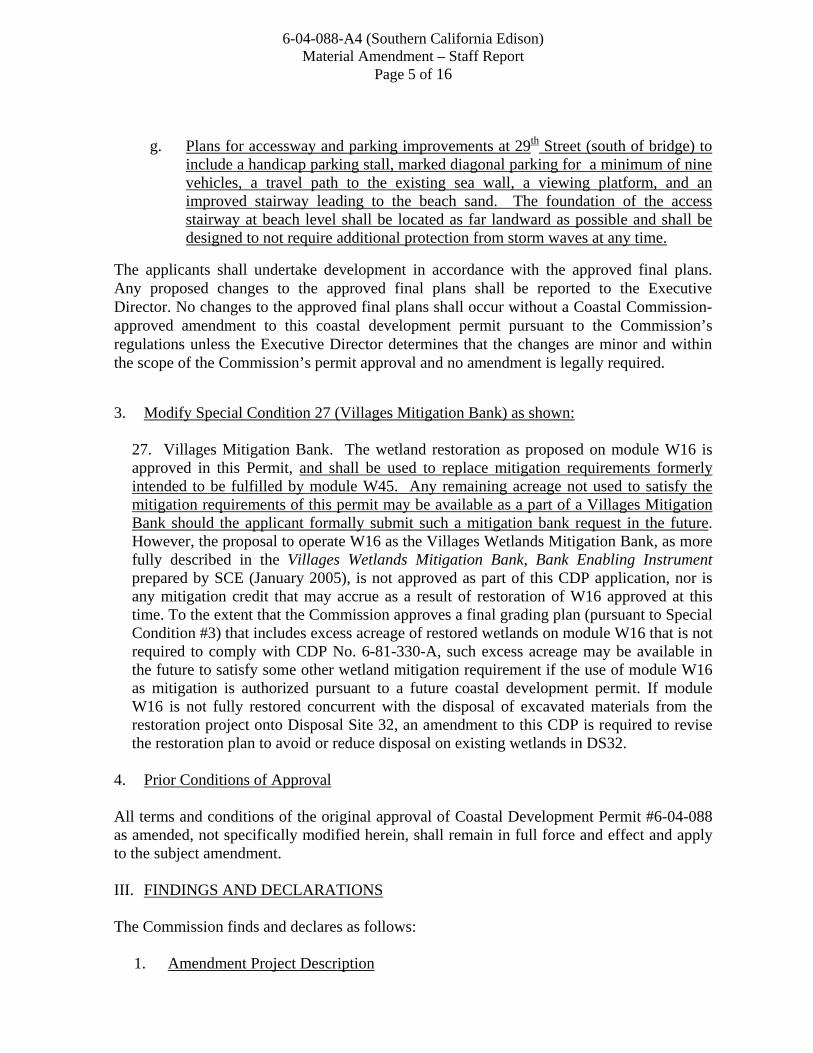
g. Plans for accessway and parking improvements at 29th Street (south of bridge) to
include a handicap parking stall, marked diagonal parking for a minimum of nine vehicles, a travel path to the existing sea wall, a viewing platform, and an improved stairway leading to the beach sand. The foundation of the access stairway at beach level shall be located as far landward as possible and shall be designed to not require additional protection from storm waves at any time.
The applicants shall undertake development in accordance with the approved final plans. Any proposed changes to the approved final plans shall be reported to the Executive Director. No changes to the approved final plans shall occur without a Coastal Commission-approved amendment to this coastal development permit pursuant to the Commission’s regulations unless the Executive Director determines that the changes are minor and within the scope of the Commission’s permit approval and no amendment is legally required.
3. Modify Special Condition 27 (Villages Mitigation Bank) as shown:
27. Villages Mitigation Bank. The wetland restoration as proposed on module W16 is approved in this Permit, and shall be used to replace mitigation requirements formerly intended to be fulfilled by module W45. Any remaining acreage not used to satisfy the mitigation requirements of this permit may be available as a part of a Villages Mitigation Bank should the applicant formally submit such a mitigation bank request in the future. However, the proposal to operate W16 as the Villages Wetlands Mitigation Bank, as more fully described in the Villages Wetlands Mitigation Bank, Bank Enabling Instrument prepared by SCE (January 2005), is not approved as part of this CDP application, nor is any mitigation credit that may accrue as a result of restoration of W16 approved at this time. To the extent that the Commission approves a final grading plan (pursuant to Special Condition #3) that includes excess acreage of restored wetlands on module W16 that is not required to comply with CDP No. 6-81-330-A, such excess acreage may be available in the future to satisfy some other wetland mitigation requirement if the use of module W16 as mitigation is authorized pursuant to a future coastal development permit. If module W16 is not fully restored concurrent with the disposal of excavated materials from the restoration project onto Disposal Site 32, an amendment to this CDP is required to revise the restoration plan to avoid or reduce disposal on existing wetlands in DS32.
4. Prior Conditions of Approval All terms and conditions of the original approval of Coastal Development Permit #6-04-088 as amended, not specifically modified herein, shall remain in full force and effect and apply to the subject amendment. III. FINDINGS AND DECLARATIONS The Commission finds and declares as follows: 1. Amendment Project Description
6-04-088-A4 (Southern California Edison) Material Amendment – Staff Report
Page 6 of 16
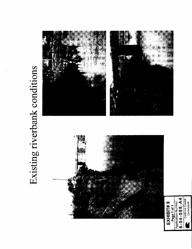
The proposed amendment includes three unrelated modifications to the special conditions placed on the original permit (CDP #6-04-088). The first requested change to the permit involves the deletion of a requirement to apply a topsoil cover to the rock slope protection approved for the San Dieguito river bank located just east of Jimmy Durante Boulevard (Exhibit 5). The applicant’s engineering team has raised concerns that applying topsoil to a revetment in this location would not be practical due to the potential for future scour and erosion. The applicant has submitted new, proposed site plans for the revetment that would locate the protective structure farther landward and reduce encroachment on the river channel (Exhibit 8). The current condition of the river bank in this location consists of an unengineered revetment constructed of rip rap, rail ties and other debris (Exhibit 9). The applicant proposes that removing existing debris and re-engineering the rock as a part of the new revetment construction would create a more uniform appearance, and when coupled with the landward shift of the revetment, would significantly reduce potential visual impacts that were addressed in the original condition language. The second proposed change relates to the restoration modules utilized to fulfill the applicant’s mitigation requirements associated with the construction of the San Dieguito Wetland Restoration Project. The coastal development permit #6-04-088 required that the applicant’s final lagoon restoration project (FRP) include 150 acres of created and/or substantially restored coastal wetlands (Exhibit 2). Under the approved FRP, the purpose of restoration module W45 was to create non-tidal wetlands comprising seasonal salt marsh and a seasonal pond to mitigate for unavoidable impacts resulting from the construction of the wetland restoration project. However, prior to the commencement of construction and grading, significant portions of the site, totaling approximately 4.5 acres, were discovered to have been colonized naturally by native wetland vegetation consisting primarily of pickleweed (Salicornia virginica) and alkali heath (Frankenia grandiflora). As such, the area met the definition of a wetland regulated under the Coastal Act, and was no longer available to be used to meet the mitigation requirements of CDP #6-04-088 and the approved FRP. Additional impacts are associated with a rip rap revetment placed along the edge of the berm (B8) that parallels the San Dieguito River east of I-5. These impacts were initially represented in the FRP as temporary, but upon later investigation have been determined by the Commission’s staff biologist and contract scientists to be permanent, and therefore would require additional mitigation. Restoration module W16 was included in the environmental documents for the FRP but was not required to be utilized to meet the mitigation requirements under CDP #6-04-088. Instead, W16 was proposed to be created as a mitigation bank of credits, called the Villages Mitigation Bank, to be used for future SCE projects. This amendment now proposes to use the majority of the wetlands created in restoration module W16 to replace the wetland creation mitigation formerly required to take place at W45, as W45 is no longer available,
6-04-088-A4 (Southern California Edison) Material Amendment – Staff Report
Page 7 of 16
and to mitigate the permanent impacts recently determined to exist on B8 (Exhibit 4). This replacement would allow for the applicant to meet the total mitigation acreages required under the approved FRP and CDP #6-04-88. The third component of this amendment request relates to the timing of the construction of public vertical beach accessways on either side of the inlet opening. As currently conditioned by the permit, the applicant must submit approval from the City of Del Mar for the proposed accessways prior to the commencement of inlet dredging, which is expected to begin in the fall of 2010. The majority of the restoration construction and dredging for the lagoon (except the inlet opening) have been completed at this time, however the City of Del Mar only recently approved the north accessway (April 5, 2010), and has yet to approve the proposed south accessway submitted by the applicant. Dredging the inlet opening to ensure maximal tidal flushing is an essential component of the restoration plan, and delaying this action has the potential to impede many of the successes currently achieved by this restoration project. The applicant has therefore proposed that an extension of twelve months be added to the condition language of this permit related to the time required between inlet dredging and submittal of accessway plans approved by the City of Del Mar. The lagoon and surrounding areas are in an area of filled tidelands where the Coastal Commission retains coastal development permit authority permanently. Chapter 3 of the Coastal Act is the legal standard of review, but the LCPs for the Cities of Del Mar and San Diego are used as guidance, as portions of the beach and lagoon are within both jurisdictions. 2. Description of Project Originally Approved and Subsequent Amendments ORIGINAL PROJECT DESCRIPTION: The San Dieguito Wetland Restoration Plan was proposed primarily to meet the requirements of Coastal Development Permit #6-81-330 to mitigate adverse impacts to the marine environment occurring through operation of the San Onofre Nuclear Generating Station (SONGS) Units 2 and 3. Southern California Edison (SCE), the principal owner of SONGS, was required to provide approximately 150 acres of new, or significantly restored, wetland habitat. Maintenance of the lagoon tidal inlet was considered a key component of the restoration plan and SCE was therefore granted 35 acres of wetland mitigation credit for agreeing to maintain the inlet in an open condition in perpetuity. Coastal Development Permit #6-04-88 for the construction of the wetland restoration project included these requirements. Additional components of the restoration project included the construction of three berms adjacent to the San Dieguito River to confine existing flows and maintain sediment transport to the ocean, bank protection for portions of the berms, culverts in the berms to help balance water levels and a weir to eliminate any backwater effect on the upstream river channel, the creation of four new nesting sites and rehabilitation of an existing site for the California Least Tern and Western Snowy Plover, the creation of treatment ponds to filter freshwater runoff and reduce freshwater flows into the restored tidal wetlands, the construction of a public access trail, including interpretive signage, and improvements to beach access, the upland and beach disposal of excavated material, and maintenance and monitoring programs.
6-04-088-A4 (Southern California Edison) Material Amendment – Staff Report
Page 8 of 16
The San Dieguito Wetland Restoration Plan encompasses almost the entire San Dieguito River Valley west of El Camino Real, although SCE is only responsible for restoring a portion of that area. Other portions of the restoration plan will be implemented by the San Dieguito River Park Joint Powers Authority (JPA). It was originally approved by the Commission on October 12, 2005. Since that time, there have been several amendments, as follows: 6-04-088-A1: Immaterial amendment to modify the language of Special Condition #4
related to the timing of berm construction. Approved August 10, 2006. 6-04-088-A2: Material amendment to remove approximately 4,000-5,000 cubic yards of
material along an 800' long, 60' wide road and berm. Approved July 7, 2007. 6-04-088-A3: Withdrawn August 7, 2007. 6-04-088-A4: Material amendment submitted August 14, 2007, subject amendment request
of this staff report. 6-04-088-A5: Immaterial amendment to modify the language of Special Condition #8
regarding coastal sage scrub mitigation for the trail and treatment ponds. Approved October 11, 2007.
6-04-088-A6: Immaterial amendment to allow the use of 40-foot long, 20-foot wide bridges
to cross the drainage channels on both sides of I-5 for the continuation of the Coast-to-Crest Trail instead of the use of open bottom concrete culverts, resulting in a reduction of permanent wetland and upland impacts. Approved February 5, 2008.
6-04-088-A7: Immaterial amendment to establish a pedestrian-only trail along an existing
slope stability bench on the engineered slope of Disposal Site 32 (DS32) located directly south of Via De La Valle. Approved October 9, 2009.
Presently the majority of the grading and construction described within the FRP has been completed; the outstanding portions of the FRP yet to be initiated include the inlet dredging and construction of the riverbank revetment. Significant native floral and faunal populations have already begun repopulating this coastal lagoon system.
6-04-088-A4 (Southern California Edison) Material Amendment – Staff Report
Page 9 of 16
3. Biological Resources/Water Quality. The following Coastal Act policies related to biological resources and water quality are most applicable to the proposed development, and state, in part:
Section 30230 Marine resources shall be maintained, enhanced, and where feasible, restored. Special protection shall be given to areas and species of special biological or economic significance. Uses of the marine environment shall be carried out in a manner that will sustain the biological productivity of coastal waters and that will maintain healthy populations of all species of marine organisms adequate for long-term commercial, recreational, scientific, and educational purposes.
Section 30231 The biological productivity and the quality of coastal waters, streams, wetlands, estuaries, and lakes appropriate to maintain optimum populations of marine organisms and for the protection of human health shall be maintained and, where feasible, restored through, among other means, minimizing adverse effects of waste water discharges and entrainment, controlling runoff, preventing depletion of ground water supplies and substantial interference with surface water flow, encouraging waste water reclamation, maintaining natural vegetation buffer areas that protect riparian habitats, and minimizing alteration of natural streams.
Section 30233 (a) The diking, filling, or dredging of open coastal waters, wetlands, estuaries, and lakes shall be permitted in accordance with other applicable provisions of this division, where there is no feasible less environmentally damaging alternative, and where feasible mitigation measures have been provided to minimize adverse environmental effects, and shall be limited to the following: … (6) Restoration purposes. … (c) In addition to the other provisions of this section, diking, filling, or dredging in existing estuaries and wetlands shall maintain or enhance the functional capacity of the wetland or estuary. Any alteration of coastal wetlands identified by the Department of Fish and Game, including, but not limited to, the l9 coastal wetlands identified in its report entitled, "Acquisition Priorities for the Coastal Wetlands of California", shall be limited to very minor incidental public facilities, restorative measures, nature study, commercial fishing facilities in Bodega Bay, and development in already developed parts of south San Diego Bay, if otherwise in accordance with this division. …
6-04-088-A4 (Southern California Edison) Material Amendment – Staff Report
Page 10 of 16
Section 30240 (a) Environmentally sensitive habitat areas shall be protected against any significant disruption of habitat values, and only uses dependent on those resources shall be allowed within those areas. (b) Development in areas adjacent to environmentally sensitive habitat areas and parks and recreation areas shall be sited and designed to prevent impacts which would significantly degrade those areas, and shall be compatible with the continuance of those habitat and recreation areas.
Habitat The original permit for the San Dieguito wetland restoration project (CDP 6-04-088) required the applicant to provide 150 acres of newly created or significantly restored coastal wetland habitat within San Dieguito Lagoon. Of this total, a 35 acre credit was granted to the applicant for accepting responsibility for maintaining an open lagoon inlet in perpetuity. The Final Lagoon Restoration Plan (FRP) includes a final summary table (Exhibit 3) that describes the wetland habitat impacted by each module, and the areas where newly created or restored wetlands are located within the subject site, and the wetland acreage associated with each module. This table was used to establish that the applicant had accounted for sufficient wetland creation/restoration to meet the mitigation goals established by CDP 6-04-088 (and required in the SONGS permit, CDP #6-81-330). Restoration module W45 was represented in the FRP summary table as providing a net of 8.05 acres of wetland habitat creation as a part of the project through the creation of seasonal salt marsh and seasonal salt pond habitat within W45 (Exhibits 2 and 3). Original wetland delineations of the module conducted for the EIR/EIS when the site had still been farmed depicted an area of approximately 0.8 acres of existing salt marsh located within the module. However, later overflight data showed an area of approximately 4.5 acres within the module had been colonized by wetland vegetation. This estimate of wetland habitat was later ground-truthed by Commission contract scientist directed surveys that found colonies of pickleweed and alkali heath as well as other native and non-native salt marsh species were prevalent within the site. The module was determined, therefore to be an existing wetland under the Coastal Act definition of a wetland, and could no longer be utilized in the FRP summary table to represent newly created salt marsh habitat. Berms were created as a part of the FRP to direct river flow, maintain existing water velocities, and maintain sediment transport during storm events. The riverside edge of the berm, B8, was designed to have additional slope protection measures constructed to ensure slope stability of the berm. The installed stone revetment on B8 is approximately 1,200 feet in length and was installed to the design specifications of the FRP (Exhibit 5, 6 and 7). Some of the impacts at B8 associated with the revetment were initially described as temporary given the rationale that the intertidal rock was to be covered with topsoil, or river sediment where present in subtidal locations. After the fact, however, this rock remains exposed and
6-04-088-A4 (Southern California Edison) Material Amendment – Staff Report
Page 11 of 16
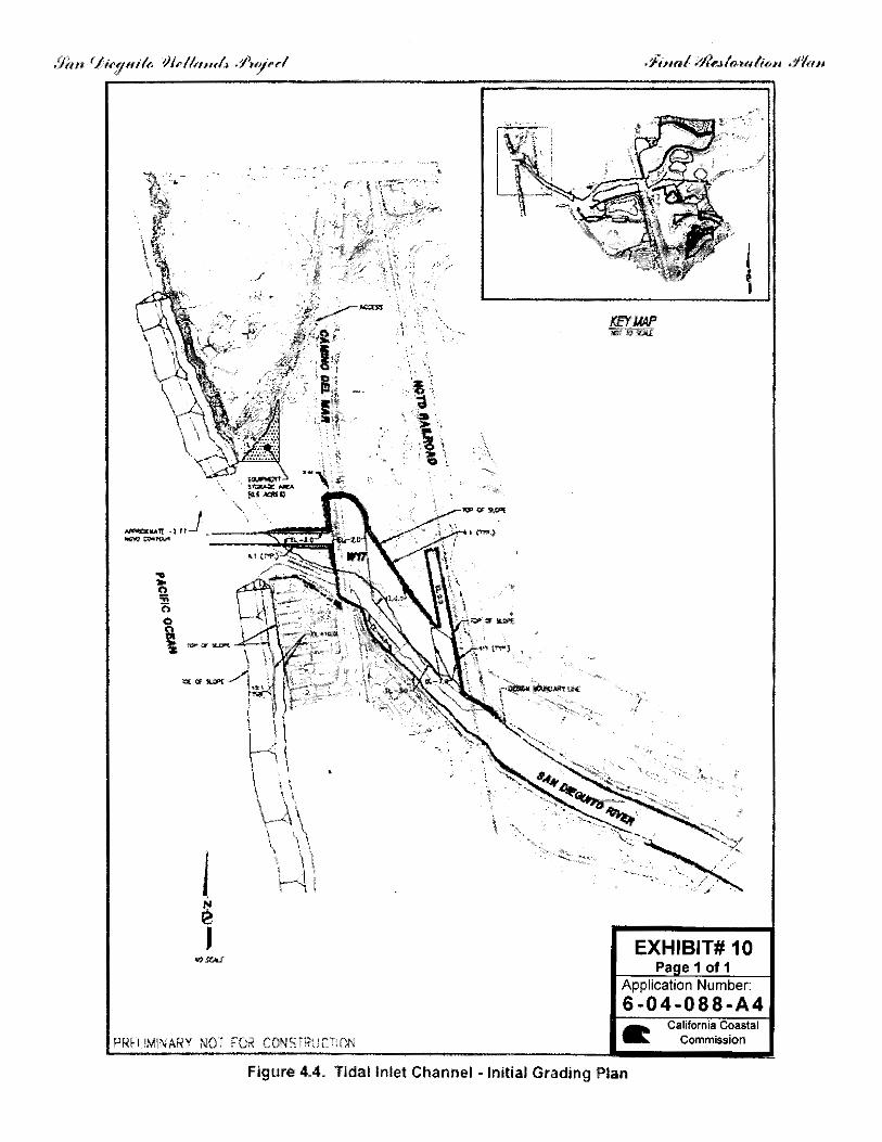
represents a habitat shift that constitutes a previously undescribed permanent impact and therefore requires adjustment of the approved mitigation and summary table in the FRP. The newly described impacts from B8 amount to an additional 0.28 acres of permanent impacts that at a mitigation ratio of 4:1, equate to the need for an additional 1.28 acres of created wetland as mitigation. Restoration module W16 was included with the original EIR/EIS review of the entire project, but was not required as a part of the permit to satisfy the SONGS mitigation requirements (Exhibits 2 and 3). W16 was instead to be designated as the Villages Mitigation Bank, and proposed as a site for potential wetland mitigation credits. A total of 20.77 acres of wetland was anticipated to be created as a part of W16 as represented in the FRP, 11.15 acres of which would be available as potential future mitigation credits. Due to the natural habitat establishment within W45, and the newly described permanent impacts associated with B8, the applicant proposes to utilize a portion of the wetlands created within W16 as mitigation credit to replace these losses. The applicant has submitted a modified summary table for the FRP (Exhibit 4) to illustrate these changes. B8 has an increased acreage of permanent impacts described in the updated summary table, and W45 is no longer listed as an area contributing to the gross amount of habitat created. The proposed replacement with W16 would still allow the applicant to provide for the necessary 115 acres of created or significantly restored wetland habitat required under the original permit. These proposed changes to the summary table have been reviewed and accepted by Commission contract scientists. Special Condition #27 has been modified to represent this change, and to allow that any remaining acreage within W16 not counted toward the 115 acre mitigation requirement would still be available as part of the Villages Mitigation Bank, should the applicant formally submit a request for a mitigation bank in the future. The proposed amendment therefore ensures that the full 115 acres of required mitigation will still take place at the project site, to the amendment, as conditioned, is consistent with the habitat protection policies of the Coastal Act. Water Quality A major component of the FRP is the opening and continued maintenance of the lagoon inlet. In its present condition, the lagoon mouth is vulnerable to intermittent closure due to sand influx, which may result in a subsequent deterioration of water quality within the lagoon system. At the present time, the majority of the lagoon excavation and construction components of the FRP have been completed, however the area of the lagoon inlet extending seaward from Jimmy Durante Boulevard to the Pacific Ocean has not been dredged (Exhibit 10). Special Condition #12 of CDP #6-04-88 requires that the applicant submit vertical accessway plans for areas north and south of the inlet mouth that have been approved by the City of Del Mar, prior to commencement of inlet dredging. Once the inlet is dredged, lateral access across the lagoon mouth will not be possible: the Commission therefore required the improved accessways to the north and south of the inlet as a part of CDP 6-04-088 in order to
6-04-088-A4 (Southern California Edison) Material Amendment – Staff Report
Page 12 of 16
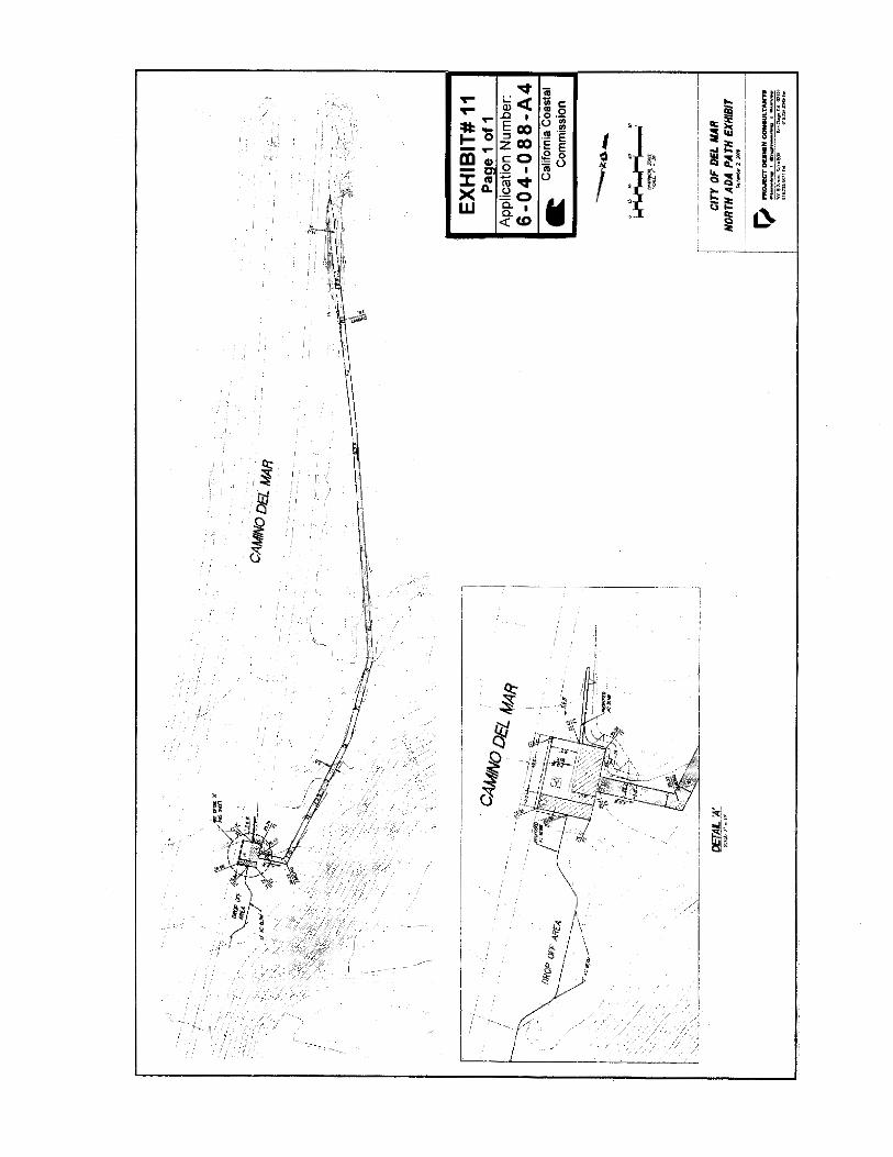
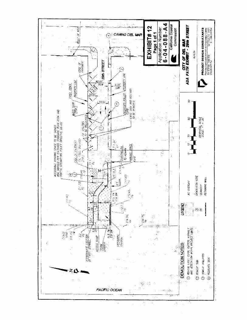
replace this loss of lateral beach access. The applicant has recently received approval from the City for the proposed north accessway, and hopes to initiate construction soon. However, at this time the applicant has been unable to reach agreement with the City on plans for the south accessway and therefore, as restricted by the conditions of the permit, the applicant has been unable to complete the FRP as approved, and dredge the inlet opening in order to maximize tidal flow for the lagoon system as a whole. The habitat within the lagoon system has already begun to respond favorably to the enhancements created through the FRP, even without the lagoon mouth being dredged. However as described previously, the system still has the potential to close due to sand inundation in the lagoon mouth. If the inlet were to close, water quality within the lagoon system would begin to deteriorate, possibly impacting the gains in flora and fauna that have become established within the lagoon. In order to ensure that the potential impacts caused from a closed or severely restricted inlet do not cause regression of the ecological progress achieved within the lagoon system, the applicant proposes that Special Condition #12 be modified to provide a twelve month extension between the time when the lagoon inlet is dredged, and when the final accessway plans approved by the City of Del Mar are submitted to the Executive Director for review. The proposed northern accessway plans (Exhibit 11) were recently approved by the City (April 5, 2010). The applicant and the City have informed Commission staff that significant progress has been made toward the design of the southern accessway, and that the proposed accessway plans included as a part of this amendment application (Exhibit 12) will likely go to the City Council for approval this summer. As modified above, Special Condition #12 incorporates this request and would allow the applicant to complete dredging activities in the upcoming months, while still actively working with the City to refine and submit plans for the southern accessway in order to get approval from the local government, thereby avoiding any negative impacts to the restoration project that might result from a restricted lagoon mouth. In order to ensure that the construction of the accessways occurs in a timely manner, the special condition language has been modified to include a requirement that construction of the accessways shall commence within sixty days of Executive Director approval of the plans for such accessway. The Commission finds that only as conditioned as described above, can the proposed development be found consistent with Sections 30230, 30231, 30232, 30233 and 30240 of the Coastal Act which require biological resources and water quality be protected, and where possible, enhanced. 3. Public Access. Section 30604(c) of the Coastal Act requires that every coastal development permit issued for any development between the nearest public road and the sea include a specific finding that the development is in conformity with the public access and public recreation policies of Chapter 3. The following Coastal Act policies addressing public access are most applicable to the proposed development, and state, in part:
6-04-088-A4 (Southern California Edison) Material Amendment – Staff Report
Page 13 of 16
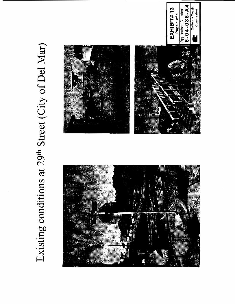
Section 30210 In carrying out the requirement of Section 4 of Article X of the California Constitution, maximum access, which shall be conspicuously posted, and recreational opportunities shall be provided for all the people consistent with public safety needs and the need to protect public rights, rights of private property owners, and natural resource areas from overuse. Section 30211 Development shall not interfere with the public's right of access to the sea where acquired through use or legislative authorization, including, but not limited to, the use of dry sand and rocky coastal beaches to the first line of terrestrial vegetation.
Section 30213 Lower cost visitor and recreational facilities shall be protected, encouraged, and, where feasible, provided. Developments providing public recreational opportunities are preferred. …
Historically the inlet to the San Dieguito lagoon has undergone periods of extended time where the inlet was either partially or completely closed due to sand influx. The restricted condition of the lagoon mouth allowed continuous lateral beach access along the sandy shore for the public beach user. In its original approval of the lagoon restoration plan, the Commission required the applicant to mitigate any impacts on lateral beach access created by the proposed dredging of the lagoon inlet. The opening of the lagoon mouth and continued maintenance proposed in the FRP would create a permanent restriction on lateral beach access along the sandy beach currently enjoyed by the public. Special Condition #12 of the original permit required the applicant to create or improve vertical beach accessways located to the north and south of the lagoon inlet so that the existing bridge over the lagoon inlet on Camino Del Mar could be more easily utilized by the general public once the inlet is opened. Additionally, to ensure that there was not a significant lag between the impacts to lateral access caused by the lagoon inlet dredging and the construction of the required accessway improvements, Special Condition #12 included the restriction that prior to inlet dredging the applicant must submit accessway plans approved by the City of Del Mar, for the review of the Executive Director. To ensure that the restoration work already completed within the lagoon is not impacted by restricted flows at the lagoon inlet, the applicant has requested a twelve month extension between the time the inlet is opened/dredged and when approved accessway plans from the City must be submitted. The Commission has included this modification into the Special Condition #12 language, but additionally, to ensure that construction of the accessways are not unnecessarily delayed after approval, the Commission has added a provision to the
6-04-088-A4 (Southern California Edison) Material Amendment – Staff Report
Page 14 of 16
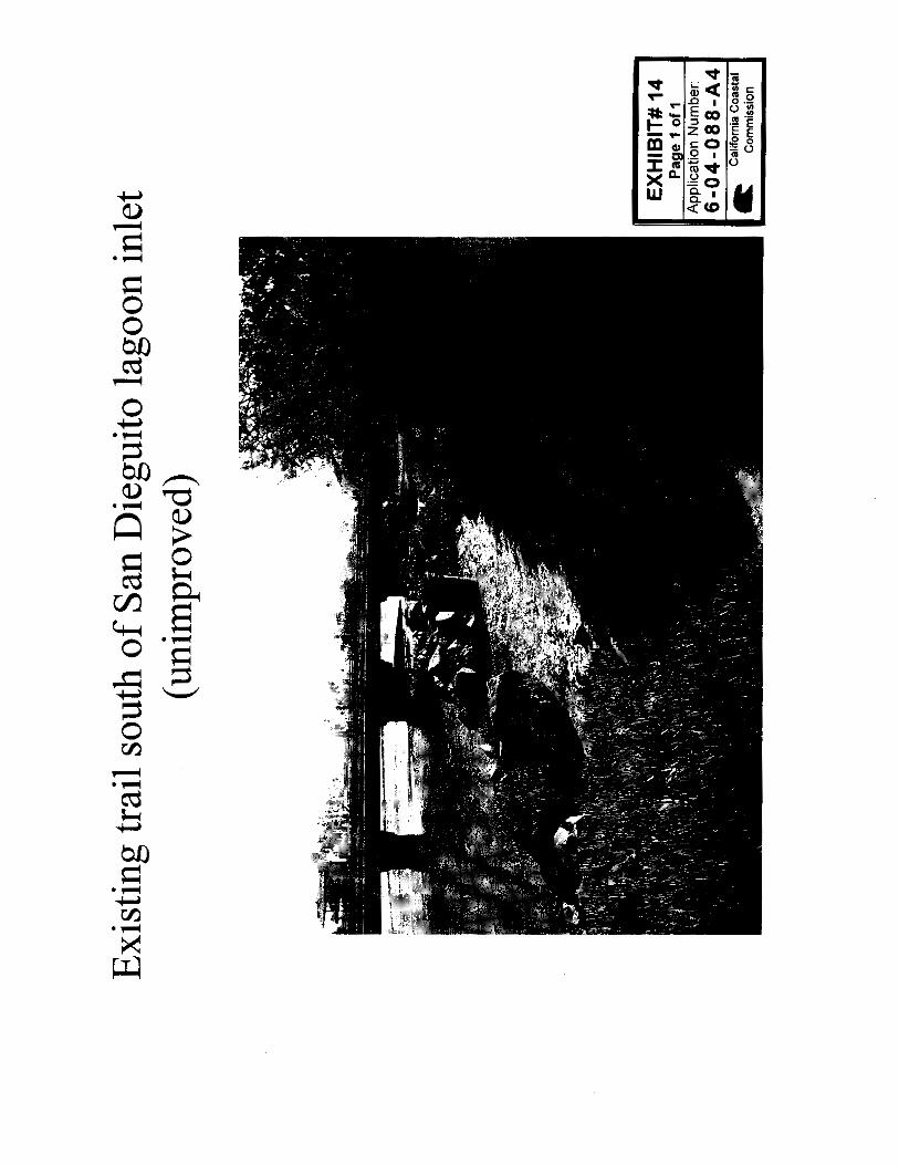
condition that requires construction on the accessways be initiated within sixty days of written approval from the Executive Director. As a part of the required vertical accessways described in CDP #6-04-088, the applicant was responsible for improving an existing trail located directly south of the lagoon mouth and extending from Camino Del Mar west to the beach sand (Exhibit 14). This trail is presently not maintained, and access to the sand from the trail is acquired by traversing an existing rock revetment. Due to the City of Del Mar’s concerns regarding potential liability associated with the trail, and existing constraints due to the trail’s location, SCE has proposed that an alternate south accessway be improved instead. The search for an adequate alternative has been one of the reasons for delay of approval from the City for the southern access. The alternative accessway now proposed by the applicant would be located a block south of the lagoon inlet at 29th Street (Exhibits 12 and 13). Proposed improvements would include a sidewalk, striping to formalize nine angled parking spaces (currently utilized by the public), an additional handicap parking space, an ADA travel path to the existing sea wall, a viewing platform, and an improved beach stairway to the sand. Signage will also be included to identify the accessway as the western terminus of the Coast to Crest Trail system. Since there is already an existing sea wall and rock revetment at this location, no new shoreline protection devices would be required. While the relocated accessway improvements are not located directly adjacent to the lagoon inlet, they will still provide the beach user enhanced vertical access to the beach sand in an attempt to supplement the impaired lateral access caused by the lagoon inlet dredging, as was intended by the original permit. The Commission has integrated this modification into Special Condition #12, with the provision that the existing path located directly south of the lagoon inlet shall not be removed or closed by the applicant. The Commission finds that only as conditioned as described above, can the proposed development be found consistent with Sections 30210, 30211 and 30213 of the Coastal Act which require public access and recreation opportunities be protected. 4. Visual Resources Section 30251 of the Coastal Act addresses the preservation and enhancement of visual resources, and states, in part:
Section 30251
The scenic and visual qualities of coastal areas shall be considered and protected as a resource of public importance. Permitted development shall be sited and designed to protect views to and along the ocean and scenic coastal areas, to minimize the alteration of natural land forms, to be visually compatible with the character of surrounding areas, and, where feasible, to restore and enhance visual quality in visually degraded areas. …
The San Dieguito River Valley provides visual relief from the surrounding commercial and residential areas. Public views to, and throughout, the valley are significant resources
6-04-088-A4 (Southern California Edison) Material Amendment – Staff Report
Page 15 of 16
requiring protection under the Coastal Act. Portions of the previously described rock revetment located along the riverside edge of B8 and above the wetland boundary of the river have been covered with soil/sediment and revegetated as described in the FRP. For the lower portions of the revetment, it was anticipated that natural sedimentation processes would cover the installed rock, however this has not occurred and the revetment remains exposed (Exhibit 7). The exposed revetment is not visible from any public trails or view points and therefore will not detract from the visual character of the overall restoration area. Coastal Development Permit 6-04-088 included the construction of a new riverbank revetment to be located just east of Jimmy Durante Boulevard along the southern river edge (Exhibit 5). This revetment would provide slope protection for a number of existing structures located along the river. The existing condition of the riverbank in this location consists of an area of unengineered fill comprised of rip rap, railroad ties and other assorted debris (Exhibit 9). This deteriorating revetment affords some protection from flooding, erosion and scour to the existing structures located just southward. The original permit required that topsoil be applied and maintained on exposed portions of any newly constructed revetment in order to mitigate for any potential visual impacts to public use areas. Engineers for the applicant have expressed concerns that topsoil placed on top of any revetment in this location would not be permanent and would likely erode away quickly due to run-off and scour patterns in this area. Therefore, the applicant is proposing to delete this requirement from the permit. At the direction of Commission staff, the applicant has shifted the location of the new revetment landward and reduced its overall footprint in an effort to decrease encroachment into the river channel, and to reduce potential visual impacts (Exhibit 8). The suggested modifications to Special Condition #4 would memorialize these proposed changes through a reference to this Exhibit (8). The updated site plan also describes a revetment with a reduced linear footprint, with the proposed new revetment extending along approximately 550 feet of river bank, compared to the approximately 600 foot revetment previously approved as a part of CDP 6-04-088. The applicant further asserts that by removing the existing unengineered debris pile, the newly constructed revetment would have a more uniform appearance, resulting in an aesthetic improvement over existing conditions. The combination of all of these proposed refinements to the original revetment design, including a landward shift of the revetment away from public viewing areas, a reduction in the ultimate size of the proposed structure, and the removal of the existing debris would result in an improved visual experience for the public, as was intended through the original condition language that required the placement of topsoil on the exposed revetment surfaces. The revised riverbank revetment plans will still require final Executive Director review to ensure that they are in general conformance with the original plans approved as a part of the FRP, and would therefore provide the necessary protection for upland developments and the riverbank itself required as a part of CDP 6-04-088. Therefore, the Commission finds that the proposed amendment, as conditioned, is consistent with Section 30251 of the Coastal Act.
6-04-088-A4 (Southern California Edison) Material Amendment – Staff Report
Page 16 of 16
5. Local Coastal Program The Cities of Del Mar and San Diego have fully certified Local Coastal Programs (LCPs) and issue their own coastal development permits (CDPs) throughout most of their coastal zone areas. However, the subject site is an area of filled tidelands within wetlands; this area remains under the Coastal Commission’s jurisdiction, and Chapter 3 of the Coastal Act is the legal standard of review. Parts of the restoration project are located in the Torrey Pines Community Plan for North City in the San Diego LCP, with the rest located in the City of Del Mar’s LCP jurisdiction. Both LCPs call for protection and enhancement of natural resource areas, and the overall restoration plan was found consistent with both LCPs. The proposed project serves to protect the resource value of the area, and is thus consistent with both LCPs. Therefore, the Commission finds that the proposal, as conditioned, will not prejudice either City’s ability to continue implementation of its certified LCP. 6. Consistency with the California Environmental Quality Act (CEQA). Section 13096 of the Commission's Code of Regulations requires Commission approval of Coastal Development Permits, or permit amendments, to be supported by a finding showing the permit or amendment, as conditioned, to be consistent with any applicable requirements of the California Environmental Quality Act (CEQA). Section 21080.5(d)(2)(A) of CEQA prohibits a proposed development from being approved if there are feasible alternatives or feasible mitigation measures available which would substantially lessen any significant adverse effect which the activity may have on the environment. The proposed project has been conditioned in order to be found consistent with the Chapter 3 policies of the Coastal Act. As conditioned, there are no feasible alternatives or feasible mitigation measures available which would substantially lessen any significant adverse impact which the activity may have on the environment. Therefore, the Commission finds that the proposed project is the least environmentally-damaging feasible alternative and is consistent with the requirements of the Coastal Act to conform to CEQA.