california site and situation - cabrillo college home page
TRANSCRIPT

California Site and Situation I. Define Geography - Fennemin's model (Lecture Diagram) II. Physical vs. Cultural Geography Physical - the stage Cultural - the play Topical vs. Regional Approach - differences liabilities and virtues of each approach. III. Organization of the course. Three units 1. Physical 2. Topical (cultural) 3. Regional (Cultural).
Read Motalvo (ref. pg. 3) IV. Define SITE and SITUATION Site - Internal structure, give examples Situation - External relationships A. SITUATION of California 1. Surrounding states, Mexico, (Alta vs. Baja California) Pacific Ocean esp. useful for ports and commerce. 2. Location within the U.S. and size comparison with other states. Third in size after Alaska and Texas. (158,693 sq. mi.) California is larger than Great Britain, Japan, Italy, or Norway. a. Length of state 1) Straight line Ore. to Mexico 758 mi. (1220 km) 2) Contour of Coastline 1072 mi. (1725 km) ex. islands. 3) Straight line Oregon coastline to Cal. s.e. border is 828 mi.(332 km) Colorado- Gila River confluence. 4) Medial Line Ore. to Mex. Border 780 mi.(1255 km.) b. Width of State 1) San Francisco to Tahoe (narrowest) 150 mi.(241 km.) 2) Point Arguello (near Pt. Conception) to Nevada Border (widest) 257 mi. (414 km.) 3. Linkages (road, railroad, air etc.) with other states. 4. Note isolation due to deserts to the east and this historical problem for early migration. B. SITE of California 1. Boundaries: History, final boundary locations, size of state, shape of state. ref. Treaty with Spain 1821 established the 42nd parallel. (see 3e. below) a) History 1) Treaty of Guadalupe Hidalgo Feb. 2 1848 ceded California, Nevada, Utah, Most of New. Mexico, and Arizona, parts of Wyoming, Colorado, and Texas along the Rio Grande River. 2) Constitutional Convention- Colton Hall, Monterey Sept. 1849 a. No question about the name of new state. b. Much debate about borders: Some wanted to go to Rocky Mtns., others 108th Meridian, (the east side of the treaty boundary), others along the crest of the Sierra Nevada’s. c. There was confusion because some of the lands were only partially explored and few realized their extent. 3) Final borders established are: a. Beg. N.E. Corner the 120 West Meridian boundary between Lat. 42 to 39 N. (Lays in Lake Tahoe, probably not known by convention) b. Next a St. line connects 120W,39N with point where the Colorado R. crosses the 35 th parallel. c. From there along Colorado R. to its confluence with the Gila R. d. Then west (by treaty) to a point of 1 marine league (3.45 mi. 5.55 km) S. of the southern tip of San Diego Bay.
1

2
e. The northern boundary is the 42nd parallel. which also defines boundaries of Nevada and Utah. This dates back to the Florida Treaty ratified in 1821 which in addition to Florida marked off the boundary lines between the U.S. and Spanish - American possessions west of the Mississippi R. at that time.
4) Survey problems: Aurora was County seat of Mono Co. but in 1899 found to be inside of Nevada. 5) Note: San Diego is east of 90% of Washington & Oregon and about 40% of Nevada.
b) Shape of California
Ratio of length to width 3.5 to 1 causes problems for the state. Climate variation, water availability and need etc i.e. Northern Cal. S.F with water to southern Cal. L.A. little water. also regional identity, loyalty, more important than political party affiliations.
2. Natural vs. Cultural Boundaries a. Natural Colorado River Gila River Pacific Ocean b. Cultural 42nd parallel, Diagonal line Tahoe - Col.R. Mexico by treaty. Note: No real acceptable justification for the location of these boundaries. Actually no boundary line is better than any other in today's world. In old days Mtns., Rivers, etc. made sense, but not today. What if all of Colorado R. was inside of California ? Consider - WATER RIGHTS Cal. would own all of the Col. R. water. 3. Longitude and Latitude lecture about 35 minutes. (Lecture notes or a good geography book) 4. Maps and Mapping – Cadastral Systems a. Metes and Bounds b. Rectangular Survey c. Subdivisions d. Don’t forget map reading assignment.
END

LANDFORMS OF CALIFORNIA
Visual Aids Needed : Block diagram of plate tectonics (overhead projector) Large wall state map Outline map for student use or map in text Video “California Making of a Continent Pt 3” 1
hour Objective: To locate and become familiar with the
origin of the major landforms of California. I. Lecture Outline: A. Plate tectonics in general B. The unique situation of California C. Development of ancient landforms D. Current Landforms and physiographic provinces
(Map) E. Faults and earthquake potential (Map) F. Limits on land use in earthquake prone areas II. Lecture Notes A. Plates See Text p.36-7 fig. 2.7-2.8 1. Pacific 2. North American 3. Plate boundaries (location) 4. Subduction 5. Crustal deformation Explain igneous, sedimentary, metamorphic
rock types 6. Mountain formation and types (handout) a. fault block b. folding c. volcanic d. plateaus and plains e. dome mtns. f. complex mtns. 7. Alluvial Material B. California's unique landforms 1. Mountain types - fault block, volcanic, complex 2. Fractures and faults 3. The San Andreas Fault movement for last 12
Million years 4. The Pinnacles and Gorman 360 mile
displacement along the fault.
C. Ancient California Landforms Discussion: 1. Formation of Sierra Nevada’s 2. Coast Ranges 3. Central Valley 4. Transverse Ranges 5. Volcanism and its northward migration 6. Development of Lakes and Rivers 7. Sedimentation and alluvial fill 8. Formation of a Geosyncline and origins of
Petroleum,and coal D. Current Landforms - Name and locate: Ref. Fig.
3.1, p. 41 1. Sierras -Fault Block - 460 miles, largest range in US 2. Coast Ranges- several, complex 3. Central Valley - Geosyncline 4. Southern Cascades- volcanic 5. Modoc Plateau- volcanic 6. Great Basin- Horst and Graben 7. Transverse Range- complex 8. Lake Tahoe - Glacial, + faulting, and assists
from Quaternary volcanism 9. Klamath Mtns.- most complex in state = up
warp, an extension of Sierra topped with quaternary lava flows from southern cascades
10. Salton Sea - Man made by accident - to be discussed later.
11. Major Rivers a. Sacramento R. b. San Joaquin R. c. Other Rivers American, Eel, Kings, L.A. etc. to be discussed at length in Native Water Lecture E. Faults and Earthquakes (Map fig. 2.1 p.27) F. Land Use in Earthquake Country 1. House types 2. Urban locations 3. Survival tactics
End
1

CLIMATE OF CALIFORNIA VISUAL AIDS: Wall map of world climates Seasons Diagram Objective: At the end of the lecture the student will understand the various climates of the world and particularily California's. The student will be able to make a general map of California's Climatic zones. Order of Discussion: A. World weather in a nutshell. Duration about 2 hours (Lecture and Text). Seasons Wind patterns Types of lifting Storm types Resulting climates The Mediterranean Climates B. How California fits into the world climate regimes, other places which have a similar climate type. C. The variation of climate within California D. The rapid change of climate within short distances E. The effects of climate on the agricultural, recreational, urban, and other land use practices in California.(briefly). F. California Climate 1. Variation in Cal.- S. Dakota to Boston example 2. L.A. = a desert- define evaporation exceeds precipitation 3. Climate and economic development 4. Windward vs. Leeward Slope 5. Rain shadow =Central Valley 6. Land - Sea Breeze 7. Santa Ana Winds- read from dime novel 8. Climate and air pollution 9. Climate controls - p.85-93 Miller 10. Air Masses and Calif. mP,mT,cP 11. Adiabatic Lapse Rates Fig. 4.5, p. 86 (5.5 and 3.2 oF/1000')
END
1

SOILS OF CALIFORNIA
Handout - Storie Map of California Soils Purpose: To explain the natural native soils of California Objective: At the end of this lecture the student will have a good understanding of how soils are formed, their classifications, and their spatial patterns in California. I. Soil Formation A. Soil forming factors 1. Parent Material - Influences initial fertility, texture 2. Landform - Influences depth 3. Climate - Influences speed of formation, drainage 4. Biological Activity - Influences rate of plant decay, fertility. 5. Time - determines zonal or azonal soils II. Soil Classifications A. Pedogenic Regimes 1. Podzolization 2. Laterization 3. Gleization 4. Calcification 5. Salinization. B. The Seventh Approximation; It is inappropriately complex for this course. C. Agricultural Soil Suitability (STORIE) Index, Grades 1-6 1. Most useful for agricultural uses and therefore for this course. 2. Discuss Soil Types and explain Index III. Discuss California's Soil Distribution A. Strengths: Most of Cal. soils are good in well-drained areas. Storie map review with class B. Weaknesses: Best soils coincide with preferred Urban growth areas due to easy digging and ease of lot layout in flatter landscapes. Miller dwells on this note as you read the text.
End
1

Natural Vegetation Purpose: to acquaint the student to the distribution of native vegetation within California. I. Explain the difference between native and introduced plant types. Historic implications see VI. below. II. Relationship between Vegetation and A. Topography (PPT.- windward vs. leeward - Vertical zonation. B. North-south climatic change due to latitude. (PPT & Insolation etc.) III. Amounts of vegetation A. Only 14% of Cal. is urbanized or cultivated. B. High ranking in lumber and range cattle production. IV. Types of vegetative cover. A. Biomes - Terrestrial Ecosystems p. 143 Fig 7-1 1. Forest - Ample soil water and heat. Crown shades ground. 2. Woodland- canopy coverage 25-60% 3. Savanna Woodland - widely spaced trees with grass. 4. Parkland or grassland- Mostly grass; few if any, trees. Moderate shortage of soil water; adequate heat. 5. Desert- extreme shortage of soil water; adequate heat. 6. Tundra- Insufficient heat. 7. Riparian vegetation = along water courses, mainly trees. B. General Vegetation Groups Map Handout 1.0 Coniferous forests - 21 % of area in California. a) briefly explain coniferous vs. deciduous trees b) Name types 1,2,3,5 needle pines. Others like juniper 1)Also Redwoods (Gigantia & Sepervirons) only grow in California. “Largest” and tallest trees. 2) Bristle Cone Pine = oldest living thing. Located in the White Mtns. c) Douglas Fir = most prolific. 1.1 Coniferous Woodland - 3 % of area in California. 2. Oak Woodland - 11% of area in California. Name types of oaks deciduous vs. evergreen 3. California Prairie - 22% of area in California. 4. Chaparral - 9% - (dwarf) forest biome, scrub oak, Manzanita. 5. Sagebrush - 8% - (semi) desert biome, less dense than #4 6. Desert Shrub - 25% - much bare ground xerophytes & creosote Bush 7. Marsh Grass - less than 1% of area in California. 8. Barren - 1% incl. Tundra not usable, high mountains. 9. Littoral - 1% Shore line. V. Transects and distribution Miller P. 148 Fig. 7.6 Vertical Zonation A. Transects show the vertical zonation well and several transects show N-S chg. caused by Latitude differences. B. Distribution - to show patterns of arrangement of plants. VI. Effects of Introduced Species A. Takeover and destruction of native species. B. Change of "landscape" - eucalyptus as the example C. New species of grasses better than native grasses for animal grazing. Some species introduced accidentally. D. Climatic controls still limit range of introduced species. i.e. freezing and eucalyptus, ice plant etc. End
1

Native Water Purpose: To acquaint the student with the natural water resources of California. I. Hydrologic Cycle Review – diagram Fig 5-2, pg.101. II. Rainfall Map -
A. 70% of stream flow comes from wettest 20% of the state. B.
III. Locations of Major Rivers – Fig. 5-1,pg. 99 A. Sacramento R. System = 1/4 of state runoff B. Northwestern Rivers = 1/3 of state runoff C. San Joaquin R. = 14% of state runoff and water moves north toward S.F. Bay and therefore away from most of pop. D. Most rivers flow away from Los Angeles (Southern California) E. Show Major Lakes - note no Salton Sea until 1907 and some like Owens, Tulare are now gone. F. Explain the difference between Saltwater and Freshwater Lakes and the reason. IV. The need to Flush S.F. Bay & Fisheries Dependence on Rivers. Especially; salmon, steelhead etc. V. Precipitation is Seasonal A. (winter) when agricultural need is small. B. (summer) rivers are at their lowest when Ag. need is great. C. Runoff is mainly in winter to early spring D. Sierras - High value as a snow (water) reservoir, since max. discharge is in late spring to early summer. E. Problem how to get a steady supply of water when & where needed. GREAT NEED FOR MANAGEMENT OF DISTRIBUTION & STORAGE VI. DELTA at Gold Rush A. Mosquitoes B. Large area of flooded land in winter-spring C. Hard to cross D. Spring flood summer drought = difficult to farm E. Miners had little vegetables = Miner's Lettuce. F. Story of mid-western farmer's ignorance of irrigation. and resultant opinion that Cal. would always be dependent on
other areas for vegetables & fruits. Today Cal. Cent. Valley = 25% of all fruits & Veg. in U.S., mostly irrigated land. VII. Uncontrolled Rivers - feast to famine esp. in S. Cal. A. Deserts - flash flood danger. B. Undependable distribution of Ppt. VIII. MOST IMPORTANT = Great disparity between north and south ends of the state. Population preferences after
start of the 20th century were to areas with insufficient water. THIS LECTURE SETS THE STAGE FOR LECTURES ON WATER PROJECTS PORTION OF THIS COURSE.
END
1

Natural Resources of California Purpose: To acquaint the student with the various natural resources of California and to learn their distribution. I. Define Natural Resources - any useful property that is native to an area. A. Used to be limited to extractive industries like iron ore or coal etc. but today it includes recreation, tourism, etc. B. Excludes purely cultural decisions i.e. Las Vegas - it's there because of a) cheap land b) relaxed gambling laws c) cheap power. The place would otherwise probably become a ghost town if a) gambling would become
against the law (or just as important ) b)if California relaxed its prohibition on casino gambling). II. California's Most Important Natural Resources A. WATER most important. One of state's greatest assets and its greatest problem. 1. Indians and missions and early settlers located near water since it does not fall from sky on regular basis like out east. 2. Now we irrigate over 8 million acres of land & support some of world's largest urban complexes in an arid climate.
3. Calif. normally has ample water within the state to support both its agricultural base and its urban areas, but growth will soon be limited if more water is not diverted.
B. SEAFOOD 1. Cal. ranks 2nd. in Seafood production in the U.S. Louisiana 1st, Alaska 3rd, Then Virginia & Mass. 2. Over 600 million lbs. from over 60 species harvested. 3. 200 mile zone for enforcement of American laws apply. 4. Industry started 1849, by Italian immigrants in S.F. 5. Shortly after Chinese fishermen: caught much Cod, halibut, & sardines 6. First cannery 1864 on Sacramento R. 7. By 1900 canneries at S.F., Monterey,& San Pedro - which is now the leading fishing port in the nation. 8. Recently San Diego is increasing in importance. 9. Sardines over fished, declined in 1940's - Cannery Row Monterey, John Steinbeck. Last cannery closed in in
1964, but fish are coming back - used for bait. 10. Pollution and over fishing = depletion both fish and shellfish. Natural reproduction no longer keeping up with demand. C. TIMBER 1. There are 42,500,000 acres of forest land in Cal. 17,300,000 commercial, rest wilderness areas and parks 2. California is 3rd in Total U.S. lumber production after Oregon and Washington States, exceeding 5,000 million bd. ft.
per year. 3. 2 nd after Oregon in wood and wood products, lumber is one of top 10 leading industries in the state. 4. Problem - We cut it down faster than it can naturally reproduce. 5. Location is mainly in Northwestern California with Humboldt and Mendocino Co. heading the list. Since this
is the principal industry (aside from illegal substances) the counties are most susceptible to great swings in the economic health of the building industry.
D. MINERALS 1. Gold - most important to the development of state. Not much now. 2. Of the 56 new minerals found in the state, 39 are not known to exist elsewhere in commercial quantities. 3. Cal.= greatest variety of minerals in U.S. 4. Leading producer of 16 of the 60 major commercial mineral commodities mined in U.S. including: silver,
copper, manganese, tungsten, and uranium. 5. Cal. = 10 % of U.S. production of minerals = ranked 3rd in U.S., after Texas and Louisiana. 6. Death Valley = largest borate reserves in the world 7. Cal. chief producer of asphalt, sand & gravel, cement, iodine, salt, and potash. 8. Principal minerals in order (by dollar value) Petroleum, Natural Gas, Cement, Sand & Gravel, Boron. 9. Cal. lacking in coal, iron ore, but some exists.
1

2
E. PETROLEUM 1. Used by Indians to caulk canoes 2. First commercial refinery Newhall, 1877 3. By 1903 3000 wells Cal. largest producer in the nation until 1936, 12% production, 14% proven reserves. 4. Today Cal. 3rd after Texas and Louisiana (6th Nat. Gas) 5. By order Principal fields (production) a) Wilmington (by far the largest) S.Cal. b) Midway-Sunset (S.W. S.J. Val. near McKitterick) c) Huntington Beach d) Kern River (S.E. S.J.Val. near Bakersfield) e) Ventura f) Elk Hills = Largest Reserve (S.W. S.J. Val.) F. RECREATION AND TOURISM 1. Cal 1st &2nd is N.Y. in dollars spent on accommodations, amusement, and recreation facilities. 2. Over 150 state parks. 3. National Parks and Monuments 4. List is endless - Climate great, natural wonders, ski areas in mtns. deserts- Death Valley, Palm Springs, Seaside
resorts, Tournaments - Roses, Rose Bowl game, Zoos at esp. San Diego, Historical monuments -gold rush, missions, Amusement Parks- Disneyland, S.C. Beach & Boardwalk, Knott’s Berry Farm, Hollywood.
END

The Cultural Perspective I. Explain Difference Between Physical and Cultural Geography. A. Physical = 1st part of course sets the stage. B. Cultural Geography = the play or manipulation of environment. All based upon cultural values of the group. II. Define Culture A. Learned behavior - you are not born with it. B. Culture has no written rules. C. Society is the rules established by the group based upon cultural values D. Laws are formal rules of a free society, based on cultural values. E. Culture is Relative - concepts of good and bad change from one culture to another that's why foreign aid fails.
What is good for us may not be good for someone else. No absolute values for all people. Conformity within the group is necessary in most cultures.
F. Culture is the key to understanding why people behave as they do. If you understand a culture, you can go a long
way toward predicting a group's behavior. - Although not necessarily a single person's behavior. Russia has a strong fear of being surrounded and the problems associated with the arms race is a result.
G. Cultural Landscape - the interaction between people and their environment. H. Cultural History - Cultural Landscape through time. esp. if different cultures are present at different times. i.e.
Calif. example : Indians, Spanish, Mexican (mixture of indians and spanish), Americans. I. Cultural Ecology - Specific processes of man changing the environment for a special result - i.e. dams and
reservoirs, or land tenure. J. Common Cultural Values - 1. Consciousness of self and others. 2. Recognition of similarities and differences between groups of people. 3. Recognition of a Superior Being - God 4. Rules for dealing with problems of life. - i.e. crisis, rites of passage, death, birth, puberty. 5. Universal taboo - Incest 6. Love (usually all three types: brotherly, sexual, family) 7. Primitive sense of place - territoriality, physical direction and distance, location, curiosity of place (exploration) 8. Identification of life and activity = property holding, job, place within the group. III. A State vs. A Nation A. Nation = a group of people having common cultural values. B. State = a political boundary which may contain more than one culture. i.e. Former Yugoslavia was made up of
many; Croations, Serbians,etc. C. Many of the wars are fought over which culture will dominate a state. i.e. Lebanon (Christian vs. Moslems) D. A culture which recognizes no homeland = Gypsy Nation All other cultures (nations) can point to an area of the earth and say that that is where their nation's homeland is located. 1. Many states contain more than one nation. 2. Many nations have no state ( i.e. political boundaries ) E. Difference between History and Geography - both take a comprehensive view of mankind and the earth, one
stressing time bounds and the other place bounds. F. "Man apart from environment is an abstraction; in reality, no such thing could exist".- Dasmann
END


Sequent Occupance Purpose: To familiarize student with the changes in land use and practice through time in California. Objective: The student will be able to name and identify the cultures of people and how they influenced the
development of the California landscape. Ref. Miller Ch. 8 I. Introduction A. Environmental Determinism vs. Cultural Determinism 1. Env. Det. - environment determines land use. 2. Cult. Det. - culture determines land use and env. is independent of decisions. B. Middle of the road is more realistic, but Cal. development leans toward Env. Det. due to topography, variations in
climate etc. influence decisions more than would be case in a "Flat" state. i.e. Oklahoma, Nebraska etc. C. Isolation of Cal. very Important - ocean to the west, desert to the east = another Env. Det. influence. D. Define sequent occupance - sequential land use by different people through time in a given place. In California's
case; 1. Native Americans 2. Spanish Crown = 3. Mexican period =THE CALIFORNIOS 4. Americans = II. "Original Californians" Map of Tribes Fig.8-1, pg. 163 A. Arrival - between 30 and 50 thousand yrs. ago probably via Bering Strait during glacial period. Evidence - dwarf
mammoth B.B.Q. 30,000 yrs ago on Santa Rosa Island- started a Calif. tradition. B. At time of Spanish Contact 1. Population 130-300 thousand = largest pop. density of any non-agricultural native population ever discovered. 2. Languages many - 135 dialects, 20 Linguistic families. 3. Dress - little : stature - varied : house types - many as the land provided. 4. Peaceful people, little warfare, well adjusted to their environment. 5. Villages or rancherias = about 130 people. 6. Lacked the necessity for invention 7. Religion - shamanism = priest invokes gods good and bad. 8. Spanish brought disease, starvation, subjugation, death, = population decrease. By 1911 pop. down to 20,000. 9. W.H. Hustchinson (historian) said "Indians - vital to Spain, useful to Mexico, Annoyance to U.S. III. European Exploration A. Spanish- English Cortes, Coronado, Ullva, Cabrillo etc. 1. Cabrillo (Juan Rodriguez) first to enter Alta Calif. - San Diego Bay 1542. 2. Sir Francis Drake – 1579. Stayed one month. Golden Hinde (his ship) called area Nova Albion. Told of area. 3. Spanish worried about Drake's claims. Sent more explorers to Alta Calif. Francisco Gali 1584-1602. but area
largely ignored until 1760's. 4. Explain the role of the Spice Trade and relevance to Alta California’s importance to Spain. 5. Russians- 1812 Fort Ross. Russian-American Fur Co. after fur of sea otter and seal. When fur ran out they sold
out to John Sutter 1841 – Ended Russian claims to Northern California.
1

IV. Spanish Settlement A. International competition- Spanish decided to protect their claim on area by establishing: 4 Presidios-military bases started 1769 S. Diego 21 Missions- San Diego 1769 - Sonoma 1823. 3 Pueblos-3 L.A., San Jose, Branciforte (S. Cruz) El Camino Real = Kings or Royal Highway (mustard seed?, fact or fiction?) B. Presidios- 4 tot.-secular control, military outposts to protect harbors etc. Some ajoined missions. C. Missions - Most successful - 21 total 1. about 100,000 acres in size. 2. Brought Indians to one place – caused slavery, disease, death (especially from the natives point of view). 3. Economy - crude manufacturing- weaving, cattle, farming, tanning, blacksmithing, masonry, carpentry. 4. About 30 miles apart- one day on horseback. 5. Under church control. 6. Father Junipero Serra – Franciscan Priest founded many of the missions in California D. Pueblos - 3 total - supposed to be secular farming areas. 1. San Jose - 1777 first planned city in Cal. 2. L.A. - 1781 3. Branciforte (Santa Cruz) 1797 (Mission 1791) a. Supposed to be a villa, chartered frontier settlement, b. to be inhabited by retired soldiers and settlers who were well versed in trade & manufacturing. c. Given “lavish” support by govt. but not successful - reason: Few skilled artisans came because area populated
by "convicts and other undesirables". E. Less than 35 land grants given out during Spanish Period. V. Mexican Period - 1821 to 1848. A. Disintigration of Spanish empire. Sp. Am. Colonies were largely independent because of distance and poor communication. 1. 1821 Rebublic of Mexico formed 2. Alta Cal. part of republic because of trade and heir of Spain. B. Californios = non-Indian settlers & rancheros who made homes in area of modern day Cal. C. Secularization of Missions- removed church control- 1834 Lands divided up = private ranchos. D. Cattle stations - replaced mission briefly E. Land Grants- 20 in 1821 to 600 by 1846. 1. Vaqueros = cowboys. Two roundups / yr. 1.Branding 2.Slaughtering. 2. Size - 4500 to over 100,000 acres. 3. Local Ranchos - south to north in S.C. County Bolsa de Pajaro, Los Corralitos, San Andreas, Laguna de las Calabesas, Aptos, Shoquel and its Augmentation,
Arroyo de Rodeo, San Agustin, Refugio, Zayante, Canada del Rincon en el Rio de San Lorenzo, Arroyo de la Laguna, San Vicente, Agua Puerca y las Trancas, Punta de Ano Nuevo, Butano (not in county).
4. This period gave fasinating legendary (romantic) background for the state in the minds of people who came later. VI. Foreign Incursions A. Yankee Ships- brought news and trade. B. Trails and American Fur Traders- Jedediah Smith, William Wolfskill, John Fremont early 1800's. C. Led to American immigration- shift in demographic & political orientation to Alta Calif. D. Letters and word of mouth many stayed & became owners of ranchos. Told of relaxed lifestyle, climate, etc. E. By 1840's - emigrant trains were a common occurrence. many trails were established (Donners, Bidwells, etc.) F. Mexican-American War 1846 = ineffectiveness & indifference of Californio population to American takeover. G. 1848 Treaty of Guadalupe Hidalgo = territory to U.S. see map H. Gold Rush – discovered in 1848 I. 1850 - California adopted to union.
2

VII. The Gold Rush Most important event to convert Calif. to a vital part of the U.S. Harpers in 1859 "... most significant, if not the most
important event of the present (1800's) century connected with America..." A. Brought many people to the west. B. Inspired development of the Railroads. C. Increased commerce in Cal. services industry, agriculture, irrigation, yankee aggressiveness. VIII. Decline of Indian Population A. Alcohol, measles etc., bullets, culture shock B. Population 1850 100,000 : 1911 20,000 C. No real warfare - except one sided brutal events. D. Exceptions Modoc Wars- 1. Modoc tribe lived near Mt. Shasta 2. Many immigrants passed through 3. 1852 massacre of one immigrant party 4. 12 years of sporadic battles 5. 1864 forced to reservation. 6. Chief "Captain Jack" led people back home 7. fought army to a standstill in lava beds area 8. ran out of water, surrendered on 1873. 9. there are today numerous small reservations for California natives in the state. IX. Beef A. Gold rush changed production from tallow and hides to beef for food. By 1860's 3 million head. B. Large scale ranches took over smaller spreads. C. Fenced in ranges, cross breeding, meat and dairy farms. 1st. commercial dairy in state at Ano Nuevo 1860's can be seen today at state park. D. Land Act of 1851 Congress - people required to prove ownership of Spanish and Mexican land grants. Not easy
to do. Legality, morality & honesty were largely absent in result- Californios ripped off by American settlers, squatters etc.
X. Transportation- A. Isolation shaped early history of Cal. Overcoming isolation strongly affected the next phase. B. Overland Stage 1850-60's not very effective. C. Railroad Domination Central Pacific later to become Southern Pacific helped to mold the state more than any other entity. 1. 1855 local lines began - but 2. Connection to transcontinental system most important. 3. Land- 20 sections (sq. mile) of public land for each mile of track laid + loans + other encouragements (pg. 173). 4. C.P. and Union Pacific May 19 1869 - golden spike 5. "Big Four" of the C.P. - Mark Hopkins, Leland Stanford, Collis P. Huntington, Charles Crocker. Sacramento
businessmen controlled C.P. and started Southern Pacific as a holding company (now SP = Central Pacific again). a. Set rates - monopoly b. Farmers caused some violence 6. Railroads desires largely determined the growth patterns of the state- i.e. largely ignored S. Cal. until Santa Fe
(competitor) broke monopoly. 7. S.P. still owns over 10 million acres of California. 8. Brought in immigrants from China and Europe to work on the railroad. Added ethnic minorities to the state. 9. Positive contribution a. tied Cal. to rest of nation b. World trade c. population mobility 10. Negative contribution a. focal point for racial hatred b. greed c. questionable business practices d. political dealings
3

XI. Farming - Diversity A. Wide range of climatic and soil conditions. B. Dry Farming vs. extensive irrigation explain the differences C. Dry farming came first 1. During the gold rush - grains dominant 2. Cal. 2nd in nation in wheat production in 1870's. 3. Success led to orchard and vineyard farms. D. Railroad allowed for widespread markets. E. Irrigation 1. Mid 1850's Mormon settlement - San Bernardino 4000 acres under direct irrigation later in San Joaquin Valley
and Riverside. 2. Led to fruit crops, grapes, other high value agric. 3. Wright Act of 1887- "Appropriate and Beneficial Use" of waters led to growth of irrigation districts. Huge tracts of land developed
in Coachella Valley and Imperial Valley. F. Development of Water Transport Systems - later lecture XII. Oil A. La Brea Tar Pits also known as "Alders of San Estavan" Used by Indians for caulking, canoes, baskets, etc. B. Pico Canyon 1876 first commercial oil well in Cal. C. By 1895 I million bbls./yr. in production D. 1920's oil boom made plenty of oil available for cars. Fields on Huntington Beach, Signal Hills, Santa Fe Springs, Torrance, & Dominguez (southern Cal.) E. Easy availability of fuel = car= unofficial state emblem= the position that the car holds to this day. There are only five countries in the world have more cars in them than
are found in Southern California. G. WW II more need for oil and more immigration of people. H. Tidelands act of 1955 = offshore exploration for oil. Led to oil spill in Santa Barbara Channel etc. XIII Movies - A. Turn of the century Hollywood = sleepy town climate mild, open space available. Far from N.Y. - patents and the "movie trust" near Mexican border (run to from the law) By 1915 Hollywood = self proclaimed film Capital of world B. Most Important Hollywood came to = California to the rest of U.S. location shots- Cal.= America to many in the world. 1. Tourist attraction- still is 2. Industry- service cosmetics, electronics, clothing etc 3. Drew many people to live there & rest of west coast C. T.V. Takes over after 1950's uses same facilities. Hollywood now urban but old Century City, Universal City Culver City, Studio City, Burbank etc. makes T.V.
the Major customer of movie industry. XIV. The Depression Grapes of wrath - false promises and ideas. Many came but few prospered. Roy Rogers is an exception. XV. WW II. Defense Plants, Japanese Internment. A. California 1. Embarkation station for Pacific war. 2. Aviation Industry already here built up. S. Cal. 3. Ship building in Bay Area. 4. Shift to urbanized industrial lifestyle. 5. Increasing racial ambivalence toward blacks, Mexican-Americans, Japanese- Americans.
4

5
B. Internment of Japanese-Americans. 1. Why- racial hatred, unproven suspicions. The people farmed some of the best land in the state. Land
confiscated or sold cheaply. Planned rip off. Racial hatred based on hard working industrious people. 2. Manzanar- In the Owens Valley, Tulie Lake in Northern California. 3. General John L. De Witt - Cdr. Western Def. Command. 4. 110,000 Japanese- Americans from Ca. Ore. and Wash.St. C. Movement of many minorities to take industrial jobs during the war. Many military and others who later moved
to Ca. for climate etc. Also Cal. kept jobs after war as major defense contractors, aerospace, cold war, etc. kept employment high.
XVI. Recent times. A. 1950's, 60's, 70's continued growth although a slowdown at the end of the 70's. L.A. = Smog, congested traffic,
Watts riots, etc. and the new found SUNBELT of the Southwest- Texas, New Mexico, Arizona and lesser extent the Old South where cheaper land for housing, encouragement by state tax laws etc. have drawn off many to that area. MOST CALIFORNIANS SEE THIS AS GOOD SINCE THERE IS A REAL FEAR OF PARADISE LOST IF AREA BECOMES TOO CROWDED.
B. New industries 1. Continued growth in agriculture but on land that is not as good as before since urbanization has taken over
much of the prime ag. land. SPECIALIZED CROPS HIGH RETURN ON INVESTMENT i.e. raisins, garlic, wine, avocadoes, takes place of citrus etc.
2. Electronics industry started in new areas like Silicon Valley. This type of industry has mobility since it
produces a product that has little raw material transport cost and little bulk (therefore) cost to ship final product. BASIC ECONOMIC GEOG. and therefore can be RELOCATED EASILY if land, housing for workers, and oppressive environmental laws make it more productive to go elsewhere like Asia or Phoenix etc.
3. 90’s recession broken earlier in the Silicon Valley than in Southern California, but fast to rise = fast to fall? 4. State is still trend setter i.e. Prop 13, clothing, hair, etc.
End
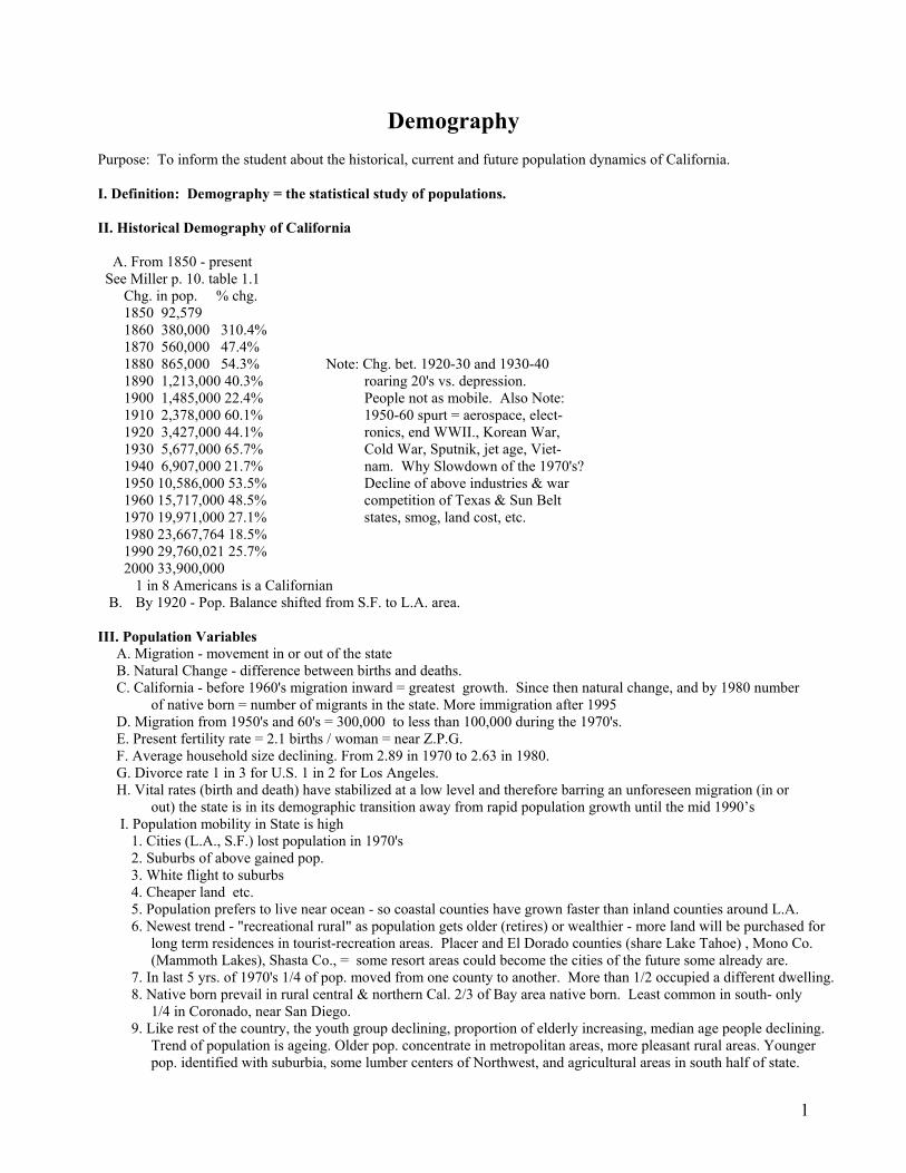
Demography Purpose: To inform the student about the historical, current and future population dynamics of California. I. Definition: Demography = the statistical study of populations. II. Historical Demography of California A. From 1850 - present See Miller p. 10. table 1.1 Chg. in pop. % chg. 1850 92,579 1860 380,000 310.4% 1870 560,000 47.4% 1880 865,000 54.3% Note: Chg. bet. 1920-30 and 1930-40 1890 1,213,000 40.3% roaring 20's vs. depression. 1900 1,485,000 22.4% People not as mobile. Also Note: 1910 2,378,000 60.1% 1950-60 spurt = aerospace, elect- 1920 3,427,000 44.1% ronics, end WWII., Korean War, 1930 5,677,000 65.7% Cold War, Sputnik, jet age, Viet- 1940 6,907,000 21.7% nam. Why Slowdown of the 1970's? 1950 10,586,000 53.5% Decline of above industries & war 1960 15,717,000 48.5% competition of Texas & Sun Belt 1970 19,971,000 27.1% states, smog, land cost, etc. 1980 23,667,764 18.5% 1990 29,760,021 25.7% 2000 33,900,000
1 in 8 Americans is a Californian B. By 1920 - Pop. Balance shifted from S.F. to L.A. area.
III. Population Variables A. Migration - movement in or out of the state B. Natural Change - difference between births and deaths. C. California - before 1960's migration inward = greatest growth. Since then natural change, and by 1980 number
of native born = number of migrants in the state. More immigration after 1995 D. Migration from 1950's and 60's = 300,000 to less than 100,000 during the 1970's. E. Present fertility rate = 2.1 births / woman = near Z.P.G. F. Average household size declining. From 2.89 in 1970 to 2.63 in 1980. G. Divorce rate 1 in 3 for U.S. 1 in 2 for Los Angeles. H. Vital rates (birth and death) have stabilized at a low level and therefore barring an unforeseen migration (in or
out) the state is in its demographic transition away from rapid population growth until the mid 1990’s I. Population mobility in State is high 1. Cities (L.A., S.F.) lost population in 1970's 2. Suburbs of above gained pop. 3. White flight to suburbs 4. Cheaper land etc. 5. Population prefers to live near ocean - so coastal counties have grown faster than inland counties around L.A. 6. Newest trend - "recreational rural" as population gets older (retires) or wealthier - more land will be purchased for
long term residences in tourist-recreation areas. Placer and El Dorado counties (share Lake Tahoe) , Mono Co. (Mammoth Lakes), Shasta Co., = some resort areas could become the cities of the future some already are.
7. In last 5 yrs. of 1970's 1/4 of pop. moved from one county to another. More than 1/2 occupied a different dwelling. 8. Native born prevail in rural central & northern Cal. 2/3 of Bay area native born. Least common in south- only
1/4 in Coronado, near San Diego. 9. Like rest of the country, the youth group declining, proportion of elderly increasing, median age people declining.
Trend of population is ageing. Older pop. concentrate in metropolitan areas, more pleasant rural areas. Younger pop. identified with suburbia, some lumber centers of Northwest, and agricultural areas in south half of state.
1

10. Men predominate in more than 1/2 of counties with outdoors industries and military bases. 11. In large metropolitan areas women predominate. 12. Unattached women mostly in central metropolitan areas 13. Unattached men - most typical where alien farm labor, military, and other special populations prevail in
diverse areas such as Imperial, San Luis Obispo, and Amador Counties. J. URBAN California - 81 % of the people live on 2% of the land. 1. 34 of 58 counties have no urbanized areas. 2. most of the 24 that do have a very small % of land urbanized. 3. 1980 census shows more than 90 % of population urban (this is still the case see p 204) 4. No change to the above seen for the future. 5. Unfortunately, much of the urban areas coincide with some of the best agricultural land. Ag. land lost due to
spread of urban areas, high property taxes and other reasons, resulted in replaced of prune orchards in Santa Clara Valley, orange groves in San Gabriel Valley, row crops in the Oxnard plain. This problem has abated some in recent years, due to gas shortages, bad commutes etc. things are going up more than out. = a more compact urban landscape.
K. Ethnic Diversity – Ref. text pgs. 252-253 1. 47% white or Anglo of many different ethnic backgrounds. 2. 32% Latino, 7% black and the last 11% Asian, 2% others and almost 1% (.8%) are American Indians. 3. Of the Hispanic group as much as 10% of the 32% may be Cuban and other Latin Americans. Only a bare
majority are California born of strictly "native" parentage due to sizable immigration over the last three decades. Mexican-Americans are nearly a majority in Imperial and San Benito Co. and almost 1/4 of all San Joaquin Valley residents (farming areas).
4. Blacks at 7% are lower than national average. Predominantly metropolitan. Family size larger than statewide averages. Education and income below total populace, but less marked than in some parts of the nation. Black ghettos persist as the most segregated of Cal. larger identifiable poor neighborhoods
5. Japanese mainly in L.A. 6. Chinese mainly in S.F. and Oakland. 7. Filipinos and Native Americans more dispersed. 8. Estimated 80,000 Native Americans in L.A.. This may represent the nation's largest concentration except for
the Navajo reservation. They are the largest populations in sparsely populated Alpine and Inyo Counties. L. Decline in Rural Farm Pop.- Technology 1. Communities not in great decline - due to influx of urban-based retirees, commuters, vacation trade. 2. Most of state land is empty 3. Abounds in scattered country acreage landscape with small towns & diminutive farms - again retirees, doctors, etc. M. Economic Status 1. Median family income 10% above national median. 2. Cost of living higher - TELL TWAIN'S STORY FROM CONN. YANKEE. 3. Affluence in metropolitan counties serving as bedroom and as expanding economic satellites for older core districts. 4. Core areas have greater extremes of wealth and poverty, but lean toward affluence. S.F. has highest per capita
while Alameda, Marin, San Mateo, and L.A. are close. 5. Low-ranking counties are within or near the Northern Highlands = frequency of retirees or fluctuating outdoors
employment. This is offset by favorable social and natural settings. N. Education 1. Strong correlation between education and affluence. 2. Largest and best system of higher education in country 3. Urban dwellers have higher levels of schooling. 4. Disparity between ethnic groups. IV. Prospects A. Concentration of people in the south will continue to be a problem. esp. water, and employment. B. North reluctant to absorb excess population - bumper stickers. C. Race relations - Cal. generally ambivalent attitudes about race relations. Poor record of promoting racial equality
and tranquility. ( Vietnamese refugees and Japanese in WWII. as good examples) D. White flight to suburbs continues. E. California has the :- 1. highest divorce rate 2. highest crime rate 3. largest alcoholic population 4. greatest level of mental health disorders 5. highest venereal disease rate 6. greatest number of deaths by automobile.
The Reason is that It is also the largest state in population in the U.S.
2

3
End

WATER NORTH TO SOUTH Purpose: To learn the great water distribution systems of California. Objectives: The student will understand the way in which natural water has been transferred from one area to
another within the state and the pros and cons of this major cultural decision. Method: In Three parts I.Brief review of native water locations II.Water Law III.The California water projects. Private, state, federal and the future of water in the state. I. Review of Native Water A. Where is it? Mostly in the North. B. Where is it needed? Mostly in the South. Review the reasons. II. Water Law – pg. 112-113 A. Riparian Rights (Sharing) 1. From English common law. 2. Applies to surface waters 3. Owner of land bordering stream or lake to use water in amounts correlated with rights of other riparian owners
to that stream or lake. B. Prior Appropriation (1st. come 1st served) 1. From Spanish law 2. Gives no preference to landowners adjoining the water. 3. Water rights are recognized on basis of use. 4. Earliest water user has preference. 5. Use protected as long as it is continuous and "reasonable". C. Correlative Rights 1. Applies to ground water. 2. Cal. = 40% of total water use. 3. Overlying landowners are entitled to ground water for "reasonable use". Rights are correlated with other land
owners overlying the aquifer. D. The California Doctrine Miller p. 113 1. Conflicts of ownership led to 1928 Amend. to Cal. Const. establishing a new water rights doctrine of "Most
reasonable beneficial use". 2. A blend of appropriation and riparian rights. 3. Problem = Cal. geographically imbalanced water distribution. Plenty of water in the north, too many people in the south. 4. The new rules a. Grandfather clause state recognized and honor water rights already in use. b. state acknowledged that riparian rights did exist. c. riparian rights of recent transfer would not be absolute, and prevents selling water above the amount required for
the land alone. d. water so important that it was declared to be used for the general welfare and for the public interest.= Subject to
state control and regulation, e. all water not used by riparian and appropriative was declared "excess water" subject to state control exercised by a
state water rights board. f. all water appropriated by the state would be deemed to be for "public uses" subject to state control. 5. The California Water Code a. Highest priority for domestic use b. next to irrigation c. Applications by a municipality for use of water by its residents is given priority over most other competing uses. d. Water Board determines allocations to serve public interests. Board must work within state water plans. e. not everyone was happy - Owen's Valley problem.
1

III. The Great California Water Projects:
A. Purpose to move water from source to people and areas in greater need.
B. Method mainly reservoirs for storage then surface canals to effect movement, then more reservoirs to hold imported water until used.
C. History of the projects. 1. L.A. Aqueduct (DWP) Eastern Sierra. pg. 113 a. L.A. appropriated water from Owens Valley, dried up Owen's Lake, and recently lowered the water level in
Mono Lake since it tapped the eastern sierra surface water flow from Yosemite south. b. Without water L.A. = semi desert c. The battle is between city and country. d. Started by William Mulholland in 1908. e. Cost 25 million, length 250 miles, took 5 years. f. pipe and flume, tunnel and trench system. g. gravity feed, no pumping required. h. generates hydroelectric power.
i. L.A. purchased riparian land, used appropriation rights ( EARLIEST USER 1776 ) etc. to get away with taking the water, but ranchers fought back using dynamite and guns-- this was the only range war in Cal. history. See Miller pg. 113-115
2. S.F. Water the Hetch-Hetchey p. 115 a. Water delivered from Western Sierras (Yosemite) to San Francisco. The great Muir controversy. b. Dept. of Interior Granted approval in 1913 to dam up the Hetch-Hetchey Valley. Project completed in 1931.
Another example of city over country water privileges. c. Length 175 miles, O'Shawnasy Dam, powerhouse (still provides cheap power to S.F.) operated by P.G.&E. d. Two reservoirs 655,000 acre feet feed Hetch-Hetchey Aquaduct. Through Diablo Range to Crystal Spring Res. Palo-Alto. e. 95 mile East Bay Aquaduct. East Bay obtained water form Mokelumne R., at the Pardee Dam and Reservoir.
Both systems provide about 1/3 of the Bay Area's water. 3. The Salton Sea pg. 61 a. Man made by accident in 1905. b. Colorado River was undammed at the time. Col. carries much material to be dumped in Gulf of California. c. Early attempts to irrigate the Imperial Valley. Used the ancient overflow channel called the Alamo River.
Started at Pilot Knob, just above the Mexican border, water diverted into Alamo for irrigation. 50 miles long, dips into Mexico, crosses border again & into the Salton Sink (-280' el.).
d. 1905 Spring heavy spring runoff from Col.R. and the lack of proper control gates caused a flood that caused the Colorado R. to enter the Salton Sink rather than the Gulf of Cal.
e. River spread to a width of 8 to 10 miles. S.P.R.R. had to move its tracks to higher ground 5 times that season, approximately 400 sq. miles of Imperial Valley were flooded.
f. Flood continued for Two Years. g. the S.P.R.R. took over from the defunct irrigation company and went to work. River ultimately put back into
its banks, but in two years the Colorado R. had created the Salton Sea from the Salton Sink. h. Salton Sea still recieves off flow from irrigation in the Imperial Valley, continues to become saltier.(evap.& salt) i. Hover Dam (1936) one of several, now controls flow of Colorado R. and stops the delivery of sediment to Yuma. j. Before dams Yuma recieved 200 million tons silt/yr. 4. Colorado River water - The Metropolitan Water District (M.W.D.) a. Established 1928 to bring water to L.A. and most of the rest of the southern parts of Cal. b. First delivery of water began in 1940 c. The Colorado R. Aquaduct serves 12 million people. d. It delivered 1 billion gallons of water daily. Due to law suits brought by Arizona ( 1953) Colorado River
water will continue to be less in the future, and the difference will be made up by water from the SWP. e. The 242 mile mile aquaduct, five pumping stations, to Lake Mathews near Riverside. ( Another 80 mile long
All-American Canal delives 3.0 million acre feet of water to Coachella and Imperial Valley. Other minor diversions around Blythe irrigate another 100,000 acres, finally Yuma Project irrigates 15,000 acres.
2

5. The Central Valley Project CVP a. Recognizes water surplus in Sacramento Valley, deficit in San Joaquin Valley. Mainly Agricultural water. b. Strengths - 1. water for ag.,indust.& domestic use. 2. flood control 3. hydroelectric power 4. improved navigation on Sacramento R. 5. control stream flow to deter salt water intrusion in Delta. 6. fish & wildlife conservation 7. recreational facilities c. Key Facilities 1. Shasta Dam - Dec. 1943 - near Redding 4th highest. behind Hover, Oroville, Glenn Canyon (Az.) 2. Captures Pit, Mc Cloud, and Sacramento Rs. in 4.5 million ac.ft. reservoir. Cal. largest hydroelectric plant
located at Lake Shasta. 3. Keswick Dam (9 mi. downstream) more hydroelectric, water flow regulation, fish trapping. 4. Tehama-Colusa Canal (40 mi. downstream) 122 mi. long. and Corning Canal (21 miles long) water to
higher elevations in Tehema County. 5. Link between Sac. and San Joaquin Valleys = The Delta Cross Channel. Near Walnut Grove goes 50 miles
to Tracy where it is pumped into the Delta-Mendota Canal for the S.J. Val. Pumps lift water 197 feet, then by gravity 113 miles southward. Supplies the San Luis Unit reservoirs & several irrigation districts along the way. Rest of water enters S.J. River at Mendota for return to the delta. This puts water back into the S.J. River because its headwaters are dammed by the Friant Dam in the foothills of the Sierra Nevada.
6. Friant Dam (20 mi. east of Madera) backs up Millerton Lake. Feeds two canals a) Madera Canal 36 mi. b)Friant-Kern canal 153 mi. to Kern R. near Bakersfield.
ALL OF THIS WAS COMPLETED BY JULY 1951 – After which:
7. Trinity Dam (Trinity River) - Clair Engle Lake. LOCATED 25 miles due west of Shasta Dam in Klamath Mtns.Province. Two more dams Lewiston Dam 7
mi. down stream, and Whiskeytown Dam on Clear Creek are to hold excess water to be put back into Sacramento R. above Keswick Dam for Central Valley needs.
8. Folsom Dam & Lake (20 mi. n.e. of Sacramento and farther upstream is Auburn Dam. on American River. Job= water control and with Folsom South Canal 69 mi. for irrigation of eastern regions of Sac. and S. J. Valleys.
9. New Malones Dam on Stanislaus River 35 mi. northeast of Modesto. Completed in 1979. Reservoir = 2.4 million acre feet (same as Clair Engle or Folsom Lake. MUCH CONTROVERSEY as it destroyed 9 miles of scenic wild rapids on Stan. R., but the State of Cal. could not stop it because CVP is funded by Feds., administered by U.S. Bureau of Reclamation part of the U.S. Dept. of Interior. CVP delivers about 6 billion acre feet of water annually to its customers, even in 76-77 drought years.
END CVP
3

4
6. The State Water Project SWP a. Another project; follows the recommendations of the California Water Plan (1947-57) b. Water use: about 1/2 goes for irrigation rest for domestic consumption (esp. to make up for less Colorado R.
water in 1985 to MWD.) compared to CVP which is mainly for irrigation. c. Multipurpose system like CVP d. Major feature = Oroville Dam on Feather R. 5.5. mi. upstream from Oroville. Comp. 1968. One of world's
largest earth and rock fill dams (770 ft. high ; Hoover Dam = 726 ft. high. Lake is 3.5 million acre ft. 167 mi. shoreline.
e. Water flows through natural beds of Feather & Sact. R. across delta lands to Tracy. Water lifted like in CVP - gravity flow to the Tehachapi Mtns. in the California Aqueduct.
f. Pumped up 3500 ft. over Tehachapi Mtns. into southern Cal. to Lake Perris in Riverside Co., (requires 14 pumping plants & 3 power generating plants) Water is also delivered to places in Central Coast, San Joaquin and Antelope Valleys, additional supply for urban S.F. Bay area, the south central coast, and Los Angeles (via Lake Perris).
g. Diversions. a) Two are the N. and S. Bay Aqui. which can deliver 255,000 ac.ft. industrial & domestic needs. b) east of Tulare Lake diversion to deliver 100,000 ac.ft./yr. to San Luis Obispo and Santa Barbara Co. on
the coast. c) West Branch Aqueduct ( 352,000 ac.ft. into Pyramid and Castaic Lk. to serve San Fernando Valley & L.A.
from the west.
h. San Luis Unit. 60 mi. s. of Tracy. (Comp 1967) federal/state financed project funded 45/55 basis. San Luis Dam & Reservoir 2 million acre ft. Capacity, O'Neill Dam & Fore bay 56,000 ac.ft. Cap., and San Luis Canal carries water 102 miles south along west side of San Joaquin Valley where it connects with California Aqueduct at Kettleman City. They act as regulators and holding facilities being moved in the Delta-Mendota Canal and California Aqueduct. Pumps lift water about 50 ft. into O'Neill Fore bay, then 310 ft. into San Luis Reservoir as needed.
i. Future project will be to bring 104 miles through the Pacheco Tunnel (10 miles) into Santa Clara and Pajaro
Valleys. (293,000 ac.ft. annually). j. Peripheral Canal is part of the SWP. It was defeated in the 1982 elections, but will probably be back later.
Object is to bring water more efficiently around the delta area, but detractors claim that the delta may be damaged during drought years if priority given to project consumers in the south. Delta damage would come from salt water intrusion.
SUMMARY OF WATER NORTH-SOUTH 1. Very complicated. 2. Calif. has the most advanced water delivery system in the world, and the most expensive. 3. The student will be expected to know about the various water plans in general only, and not be required to know
such things as storage capacity of reservoirs, heights of dams etc.
END

Agriculture in California Purpose: To show the student the major role that agriculture plays in the economy of California and the importance of
the state as a major exporter of many foods, both fresh and processed. The "off" season provider will be stressed. I. History A. Early agriculture 1. Indians were not agriculturalists until the establishment of the missions. 2. First reports to America speculated that Cal. would never be self sufficient in agricultural products. Reason -
summer drought, inconsistent precipitation. American agric. was not aware of the importance of irrigation. 3. First agriculture was mission crops and grapes for sacramental wine - the mission grape (imported) There are
some native grapes but old world vines were preferred. 4. Livestock ranching most important in Mexican period. 5. Later grain products were grown extensively. A century ago Ca. was the leader in the U.S. in wheat production,
today still in top 10. 6. Later agricultural exports spurred development of transportation. 7. Most important thing to agricultural success in Cal.= the establishment of Irrigation systems. The state has over
12.5 million acres of prime land with: a. long growing season b. fertile soils c. good drainage d. ample water supply e. microclimatic conditions f. minimal development
costs (after Irrigation system finished ) Allowed the state to become the #1 agricultural state in the U.S. 9. 1/3 of state = agricultural land, but only 1/10 is cropped. Most of state is pastoral - grazing most widely
productive land-use in Cal. 8. Value and employment of state Agricultural production = #3 after aerospace and electronics. a. Cal. provides 1/3 of nations fruits and nuts b. 1/3 of all vegetables c. many are off season to provide lettuce, celery
etc. to the nation during the winter/spring etc. These crops are worth much more for sale during seasonal scarcity. II. Overview (Ref. p 206 Table 10-1) A. More $ made/year in agric. than in all gold taken in Gold R. B. Surpasses $ made from minerals, lumber and fishing combined. C. A big problem = urbanization of prime lands. Oranges are not big anymore since best land for them is now covered
by concrete. D. Tendency toward farm consolidation. 20% reduction in # of farms in first 1/2 of 1970's. Size of farms increasing
(Table 10-2 p. 208) E. 16% of farms (the largest sized farms) did 87% of business (1974 data Cal. Atlas) F. Cal. accounts for 10% of nations agricultural production. G. 75 different crops are grown, and yields / acre for some are unmatched anywhere in the world. H Ag. Exports = 1/8 of total value of all exports from California. This equals $ 25 Billion in commodities in 1996.
For the 50th consecutive year California leads nation. Texas 2nd (13.1 Billion) I. Many ancillary jobs are created by the food production industry. For every farm related job there is about a 3/1 ratio
of service related jobs. i.e. stores, machinery sales, metals and plastics (pipes), homebuilding, etc. J. Many jobs are seasonal and poor paying. Brasero program over in 1964. Some jobs lost (esp. in canning tomato
picking) due to mechanical harvesting (U.C. ag. school) many people today do not have to migrate as in the past. Some unionization (U.F.W)
K. Surprisingly only 2% of states workforce is directly engaged in farming (about 300,000; 1980) 2/3 as laborers, 1/4 owner/operators and tenant farmers, 1/10 as managers / researchers / developers.
III. COMMODITIES A. LIVESTOCK PRODUCTS - 1.Beef and milk #1 and 2 in $ for Calif.. California has surpassed Wisconsin as #1 dairy state in U.S. 2. Eggs - nations #1 producer 3. Turkeys - usually 1st or 2nd. 4. About 4 million head of beef and 1.5 million sheep in Cal. VERY LITTLE EXPORTED - Due to distances of
markets, large local demand, perish ability. B. FEED CROPS - MOST IMPT. FOOD FOR ANIMALS. 1. Feed Crops are grown almost everywhere in state = the reason for widespread success of beef & sheep industry.
COVERS ALMOST 1/2 OF CULTIVATED LAND IN CA. 2. Imperial and Kern C. = 1st and 2nd in Alfalfa Prod. 3. CA. 1st. or 2nd. Hay 4. 2nd. to N. Dakota in Barley - 90% for feed 10% beer etc. 5. Corn for silage (feed) = $100 million/yr.
1

2
C. FIBER FIELD CROPS 1. Cotton - 1 st. Texas 2nd. $ value of cotton ranks 3rd. in the state behind beef & milk. 2. 1st or 2nd in U.S. Sugar Beets (Spreckels)and Rice 3. Irish Potatoes Ca. 2nd.(with Maine and Wash.) after Idaho in production.
(READ PP. 211-214 in Miller for more on Fiber Field Crops.) D. VEGETABLES, CITRUS, AVOCADOS 1. Ca. grows widest variety in the country. 2. 1/3 of all veg. in U.S. grown in Cal. 3. Leads nation in many (see p. 206) 4. Truck corps (veg.) = 1/5 of states ag. revenue. 5. Leads nation in avocados, lemons, olives. 20% of nations oranges (Fla.= 70%).
READ pp. 214-220 for Ventura Example. 6. Tomatoes - not a vegetable = a berry two kinds: a) cannery and b) pole (for eating directly) Pole = hand picked ;
Cannery = machine Picked see Text . for discussion on picking machines and U.C. vs. pickers. E. DECIDUOUS TREE CROPS 1. Ca. = #1 PEACH Producer, not Georgia, also #1 in ALMONDS, APRICOTS, NECTARINES, PLUMS,
PRUNES, ENGLISH WALNUTS, and PEARS. 2. Cal. = almost 100% of processed walnuts in Western Hemisphere 3. Deciduous trees are found in more northerly areas where there is greater seasonality. F. FRUIT OF THE VINE 1. Text gives nice narrative on wines and wine making. beg. p. 223+. 2. Three types of grape production a) drinking: including grape juice, wine, and brandy b) table fruit in season c) Processed: including raisins (dried), canned (as part of fruit cocktail), frozen drinks 3. Thompson seedless is most used grape type for raisins and table use. Grown mainly in Fresno area, prefers high
heat to get proper amount of sugar content and for drying. 4. Dry table wines are grown without irrigation in Val. surrounding S.F. (chiefly Sonoma, Napa, Santa Clara) 5. Sweet dessert and red table wines need higher alcohol content (sherry,or port) = irrigated lands in San Joaquin
Valley and near L.A. 6. Cal. produces 40% worlds raisins, 15% worlds table grapes, and 3% of worlds wine. 7. Geography of grape growing. See p. 228 Fig. 10-18 & Table 10-5 p. 229 for classification of grape growing areas. 8. Marketing Associations a) Theodore Kearney tried to start and later succeeded. b) Sun-Maid Raisin Growers Cooperative (there are other types of co-ops like Sunkist in citrus industry) c) Has four functions: 1) Growers own packing plants 2) establish standards of quality 3) advertising and
promoting a controlled brand 4) develops aggressive personal sales force. So, for example: raisin growers market product exclusively through their cooperative.
d) Note: There are no marketing organizations for wine, but the 300 bonded wineries and 100 fruit distilleries in state account for the production of 80% of the American wine market.
e) Cal. wines best known for a light dry table wine from Napa Vintners. G. OTHER CROPS 1. Cannabis sativa (Marijuana, pot, grass) Mulberry family a. est. production 800 million to 2 billion (tax free) $/yr. b. mainly grown in northwestern counties (sinsemilla = seedless) c. if larger value (2 billion $/yr.) is taken then pot's value is up there with cotton and grapes as dollars earned / crop. d. Cal. rapidly moving toward "self-sufficiency" in pot. 2. Turf Grass see text. used in urban areas, homes, golf c. 3. Christmas Tree Farming (silviculture) multimillion $ ind 4. Energy Crops (text) turning plant sugars into alcohol for fuel. Only practical if cost for fuel really climbs. IV. Summary of California Agriculture. A. Hard to Predict B. Some research predictions for the future. 1. moderate growth to meet increasing pop. demand. 2. growth in land under cult. = area around Central Valley 3. loss of land in central and southern coast due to urban growth. 4. food grains and citrus predicted not to grow. 5. beef steady, lower prod. in sheep, hogs, poultry and eggs 6. increase in dairy prod., tomatoes, sugar beets &
cotton 7. no change in forest, nursery and greenhouse production 8. Greatest challenge = URBANIZATION. Taking some of the best land out of production for housing.
END AGRICULTURE

Metropolitan California
Purpose: To explain and understand the role of urbanization in influencing the California landscape. I. Initial Observations A. Cal. unquestionably one of nations most urbanized states. 1. 1970 census 81% of pop. is living on 2% of the land area. 2. by 1980 census 90% are urbanized. Trend Continues in the 21st century B. Single most important observation = urban vs. agricultural land takeover. PP. 263-270. Miller. II. Historical Development A. There are only three "planned" cities in Ca. Los Angeles 1781, San Jose 1777 and Branciforte 1797. B. Most developed from presidios i.e. S.F., San Diego, Santa Barbara. Only 2 at site of missions; Ventura, San Luis Obispo. C. S.F. was the largest city (due to the gold rush) until L.A. caught up in the 1920's. D. L.A. growth very rapid after WWII. E. San Jose and San Diego have grown most rapidly in recent times. F. Today most of urban pop. in southern Cal. much political clout. G. Today 23 urban (SMSA's) in Ca. – pg. 235 Map III. City Morphology A. Cities succeed only where they provide useful services and grow only in response to demands of their areas.
There are many cities in Cal. that exist as bedroom communities for nearby cities. Called suburbs; people living there called suburbanites.
B. Classification of Cities 1. Commercial Cities - commerce and trade i.e.: farm centers like El Centro,Salinas, Stockton, Fresno,
Sacramento. Largest in Cal. are L.A.,S.F., Oakland, & San Diego. 2. Industrial Cities - Manufacturing dominates economy i.e.: Burbank, South Gate, Fontana, San Leandro, Richmond, South S.F.. Some like L.A. may also be multiplely
classed. 3. Primary Cities - extraction of nearby resources i.e.: mining, lumbering, fishing. Normally fragile economies due to being usually one-industry towns. Eamples:
petroleum - Coalinga, Borates - China Lake, lumbering - Scotia, Weed and Westwood no Cal. city is dependent primarily on fishing resources.
4. Resort Cities - recreation, health, retirement. i.e.: almost all of the cities dotting the state's coastline, also Avalon on Catalina Island, Newport Beach in Orange
Co., & Monterey, Palm Springs, some mountain cities in foothills of Sierras. ( Lake Arrowhead, Biship, Tahoe City, Mt. Shasta.
5. Government Cities - govt. paychecks, state, federal, or local dominates economy. i.e.: county seats, Sacramento, military and naval installations, ( S. Diego, Coronado, Port Hueneme, Vallejo). 6. Educational Cities - university campuses. i.e.: Berkeley, Palo Alto (Stanford), Claremont (Claremont Colleges). C. Factors influencing City Growth 1. Jobs 2. Personal decisions to locate industry by individuals in charge of industry. i.e. motion pictures to Hollywood
(Why not Ventura, San Diego, Santa Cruz?) = a personal decision based on land values, climate, shooting ease, variability of landscapes, the president's wife's living preferences, etc.
3. Location with respect to transportation hubs. 4. to a lesser degree climate, landforms, etc. D. City Growth Models 1. Burgess model - discuss zonal growth of a city. Ref. Diagram from Lecture 2. The California variation - multiple nuclei concept. 3. Growth patters affected by; a. the natural environment - mtns., rivers, topog. S.F. b. artificial barriers - railways, freeways, factories c. decisions of private developers. d. government controls - zoning regulations
1

2
4. Economic growth of a city usually enhanced by new freeway 5. 1946 L.A. first city in U.S. to establish broad zoning or districting on a broad scale. (L.A. needed it) 6. Cal. city growth is characterized as peripheral (sprawls out). S.F. only large city constrained from doing so. 7. early 1970's smaller cities began to grow faster than the large ones. This is a national trend. People seeking new
life styles. Long term residents of small towns try to keep their standard of living. = conflict. There are many local examples.
IV. Urban California A. Time does not permit detailed discussion on cities and towns. Ref. Text pp. 236-256 B. Some highlights from Miller. 1. San Francisco SOME USEFUL FACTS a. Founded as Yerba Buena (means "good grass")in 1835, also called Baghdad-by-the-Bay. b. About 60 sq. miles area (Hartman says 45). Limited on three sides, has grown up instead of out. c. Pop. declining, (1990=16,000 short of 1960 population. Housing very expensive. Much housing substandard
(i.e. 60 % of China Town). d. Usual crime problems (this is a real concern for a town which makes much $ on tourism). e. People have located across the Bay in Oakland, Marin, and farther. Big commute - listen to sig alerts!
Bridges, rail lines, freeways, BART. f. ABAG-Assn. of Bay Area Govts. has 4 million residents and 85 incorporated cities.
g. S.F. remains the cultural and financial heart of its metropolitan area.
2. Los Angeles or el Pueblo de Nuestra Senora La Reina de Los Angeles. (La Reina) = queen USEFUL FACTS: a. Lots of room to spread out, and it has. b. Pop. 1500 in 1836. c. Lots of room and mildest of Mediterranean climates. d. Boom of the 1880's ( RR fare = $1.00 (one dollar) from Kansas City to L.A. on the Santa Fe to encourage
immigration). People came. e. By the turn of century- the urban area was already spread out. f. Edward Doheny- found & developed oil west of Figueroa. g. Wm. Mulholland - water via Owens Valley. h. One Million pop. by 1920's, Today, about 3 million. i. Area 456 sq. mi. j. L.A. owns San Pedro Harbor. (Largest man made harbor on earth) k. Watts- Willowbrook = Ca. largest black community. l. S.F. Valley from desert to citrus to bedroom community in less than 70 years. 3. All Cities - Manufacturing and trade. USEFUL FACTS a. Cal. largest in country in retail trade. 1992 = 224.6 Billion (pg. 257) b. Wholesalers are moving distribution centers to suburbs. c. 1972 only N.Y. had more manufacturing employees than Cal.; 1992 California became #1 d. Alameda, Santa Clara, L.A., San Diego and Orange Co.'s = 74% of manufacturing in state, well diversified
and market oriented. Not too specialized e. San Jose city, and Orange Co. = fastest growing. f. L.A. Co. 3rd after N.Y. and Chicago in manufacturing employment. g. L.A.- Long Beach strong in petroleum production. There are 3320 shopping Malls in California
End

Recreation and Tourism Purpose: To acquaint the student with the importance of recreation and tourism to the economy of the Golden State. References: Miller pp. 223 - 226. I. - Tourism ( Travel over 100 miles away from home ) A. Ca. leads nation in tourist $ spent. Defined as revenues from expenditures, employment, and taxes by travel 100
miles or more away from home. B. 1979 Cal. 20+Billion $ ; Florida second, New York 3rd., Texas 4th. Amt. of $ is understated, since much $ is
spent on recreation more locally. ( i.e. less than 100 miles from home) C. Ca. breakdown: 53% transportation (that's why San Mateo Co. is so high on Miller's list, S.F. Airport considered
part of San Mateo) , 23% food, 12% lodging, 12% on entertainment recreation etc. D. A VERY urban oriented industry. worth 26.8 Billion (1996). California has (1987) 1,800 hotels, 2,987 motels,
and 15,795 associated recreation and amusement businesses (pg. 260). E. Biggest urban attractions are: Disneyland, Knott's Berry Farm, San Diego Zoo, Universal Studio Tours. More
people go there than to Las Vegas, but less money stays? F. Conventions - big in L.A., Anaheim, S.F., San Diego (in that order) G. Counties most dependent on tourist Dollars i.e. would be hardest hit if tourism declined. S.F. and San Mateo
where tourist $ = 29% of total personal income for the counties. State avg. = 8.4%. II. Recreation - A. Defined as the pleasurable use of leisure time. B. Most comes in small doses, usually within 50 miles of home C. There are longer trips possible i.e. weekend usually involves trips in the 300 mile round trip range, which in Ca. =
almost any environment one desires. . In terms of miles of driving: In order of popularity for one day trips. 1. About 1/2 of the total milage is for local sightseeing and study purposes. (III. below) 2. 2nd. driving to and from swimming and aquatic sports. (IV. below) 3. 3rd.roughly evenly divided in miles of driving to and from picknicking, hunting & fishing (V. below), boating,
winter activities (VI. below), horseback riding and hiking (VII. below) these are the principal recreational activities. 4. Camping and Trailering are longer than one day at a time.(Part VIII). A Closer Look III. Sightseeing and Study. All age groups can participate. A. Landscape Study - 1) scenic areas and routes, - i.e. National Pks. & Monuments, ocean views, redwood groves etc. 2) wildlife - birds, fish hatcheries, sea otters & seals, deer etc. 3) seasonal phenomena. - desert &mtn. wildflowers, snow scenes of the mtns., autumn colors. B. Historical areas - more than 550 sites and bldgs. registered as historical landmarks in Ca., 30 historical monuments, and one (Cabrillo National Monument, San Diego) national historical monument. Also the 21 spanish missions along El Camino Real (Kings Highway). The mother load country (Rt. 49). From Oakhurst to Sattley (north of Tahoe) pg.185 Fig 9-3 C. Man made structures - Disneyland = 10 million people/yr. (5X the visitation of Yosemite), other amusement parks named above. Hollywood, San Francisco, Tournament of Roses- Pasadena, zoos,
museums, resorts, theme parks (Marine Land etc.), Shasta Dam, Golden Gate Bridge, Palomar Observatory etc. IV. Beach Recreation and Boating A. There are an estimated 132 miles of Cal. beach frontage for public use. Rest (1/2 privately owned, rest state &
federal ) closed to public use. B. Well over 20 million people live within a one-hour drive of the ocean. Enough said. C. Inland lakes reservoirs & rivers = total surface area of about 1.6 million acres. (includes the Delta) Problem -
incompatibility between swimmers and boaters. V. Fishing and Hunting

A. Chiefly stream fishing - trout fishing is the biggest attraction in inland waters. Est. 19 million fish taken annually ( 2/3 natural, 1/3 hatchery)
B. Ocean fishing - important economically to some seaside towns. C. Hunting - 1979 535,000 hunting licenses sold. Most hunting trips are one day excursions. Most popular prey;
deer, water fowl, pheasants, dove, quail, & rabbits. (Deer est. pop. 1 million) VI. Winter Activities A. About 3 million visits/yr. by sightseers, 1 million more by skiers & snow players. B. 80% are one day trips, therefore near major urban areas. 1. San Bernardino Mtns.(Arrowhead & Big Bear Lakes, Mt. Baldy), and Mt. Pinos areas around L.A. = 42% of all
winter sport visitations. 2. 50% served by Sierra Nevada ( Lk.Tahoe, Squaw Valley, etc.) on the west side. within a days drive of the S.F. area. 3. Rest (8%)- East Sierras - Mammoth Lks. north. to Cascades incl. Lassen and Shasta Mtn. slopes. VII. Riding and Hiking A. Unfortunately most of the states designated riding and hiking areas are not within the one day driving range of
most urban areas. B. Located in Cascade and Modoc Plateau Provinces are about 4500 miles of riding trails, 300 miles of hiking trails,
while around L.A. only 700 miles of riding and 100 miles of hiking trails are found. C. Today over 5 million person days are spent each year on the 17,000 miles of designated riding and hiking trails in the state. VIII. Camping and Trailering A. About 30,000 campsites (state and federal lands) provide over 8 million camper days each summer. B. A permit system is employed in most areas, including backpacking in mtns. C. R.V. Industry started in 1930's with travel trailers, then to campers for pick ups and on to self-contained motor
homes in the 1960's. Sales of motor homes declined during and just after the gas shortage of 1974, but today still a going industry with some downsizing. There are now more than 1 million of them (that's one R.V. for each 24 Californians) registered in California. Therefore odds are excellent that you will either be stuck in or behind one in the near future.
1. Campsites are changing to accommodate hookups, 2. Tenters are being separated from R.V.'s 3. Private Campgrounds are being established (i.e. KOA's) IX. Recreation Areas A. Two Kinds: Public and Private 1. Private includes a. Membership clubs (hunting, ,yacht, riding, golf, church, scout, Y.M.C.A., b. Other commercial enterprises (the Thing, Mystery Spot, 17 mile drive - only toll road in Cal.,
Palm Springs Aerial Tramway etc.) 2. Public - every level of govt. included. State, Fed. Loc. a. Cal. State. several Divisions: 1) Beaches and Parks,(180 acres); 2) Forestry - four state forests for wild land use 3) Fish and Game,
recreational fishing, hunting and wild life study; 4) Water Resources, recreation at state water projects. b. Federal 1) National Park Service - 5 national parks, one national seashore, 8 national monuments, tot. 4.4 million acres. 2) National Forest Service - 20 million acres timber brush and grassland, much available for recreation. 3) Bureau of Land Management (BLM) 17.3 million acres of public domain mostly conservation and range land. 4) Bureau of Reclamation and Army Corps of Engineers provide some recreation facilities at
places like Millerton Lk. behind Friant Dam. 5) Bureau of Indian Affairs - not much, occasional Indian ceremonies, etc. c. Local County and City Numerous but few are outstanding examples within the urban environment. 1) Griffith Park: 4250 acres, L.A. 2) Balboa Park: 1400 acres, San Diego 3) Golden Gate Park: 1000 acres, S.F. All three of these have a great variety of facilities and attractions. 4) there are over 100 recreational and park districts in Ca. i.e. East Bay Regional Park District (41,000 acres)
in east bay hills with 36 parks in district. Summary: 1.If you are bored in California it's your own fault. 2.There are big bucks in leisure time. 3.Santa Cruz City is considered to be a tourist dominated economy with attendant seasonal swings in employment.
The university , Cabrillo and some small industry help to stabilize economy during the "off" season (Oct. - May). This is also true of other areas of the state which have a large % of their income as tourist (seasonal) influxes. Others not so lucky have to shut down or live off of the economic "fat" of the tourist season to see them trough the rest of their (non tourist) year. End

Peninsular Ranges Purpose: To identify that region of California which is part of the mountainous south-west corner of the state. I. Location and Justification for the Regional Boundry. A. Part of the Baja Peninsula (hence the name for the region) B. Contains landforms of granitic (batholithic) origin, fault blocked mtns., alluvial valleys, on the windward side of the state. 1. Explain batholith and granitic 2. Explain alluvial 3. Explain Fault blocked - note that most Cal. fault blocked mtns. are rotated (hinged) on the west sides, with steep eastern escarpments. C. Boundry Justification 1. East end of mountains, rain shadow desert 2. South boundry with Mexico 3. West the sea 4. North the Transverse (east-west tending) mtns., of different age, and caused by pressure along the San Andreas rift zone. Therefore deemed unique enough to be considered a different region in their own right. II. Physical Geography A. Interior Highlands. 1. Very rugged, but not high enough for alpine sports. 2. Many alluvial valleys. a. explain alluvial deposition b. good for agriculture and urbanization c. deep fill which is under water for a long time = deposition of organic material which can lead to coal and/or petroleum sources. B. Coastal Features 1. Marine Terraces along the coast. a. caused by wave action when sea level was "higher" relative to the land. Cabrillo is built on several marine terraces. b. ideal for homes, may be good for agriculture if terrace is large enough and soil is good. c. streams cut terrace canyons or barrancas into the terraces (like Porter Gulch), usually contains different native vegetation than the terraces above. Called riparian woodland or vegetation. 2. Beaches a. Longshore transport - SHOW BEACH A RIVER OF SAND b. note especially beach deprivation due to dams, harbors, etc. c. headland erosion d. sub-marine canyons C. The Islands 1. Extentions of mtn. ranges 2. San Clemente Island = Fault blocked 3. Catalina no surface symmetry 4. Santa Barbara Is. (small) and San Nicolas Is. are also part of the Peninsular ranges geologically. Uninhabited.

III. Cultural Geography A. Interior Highlands 1. Mt. San Jacinto Aerial Tramway to 11,000'. 2. Idyllwild (s.w. edge of Mt. San Jacinto State Park) is only "alpine" settlement in the ranges. Other high "towns" include Julian and Warner Springs. 3. Rugged terrain discourage urban and agricultural development. 4. Agriculture in San Jacinto Basin and coastward. Longer growing seasons, better soils, water. Fallbrook, Escondido = largest avocado area in state. Hemet, Perris, & Temecula started out as agricultural service centers. Today serve retired, military & other non-agricultural populations. 5. Retirement areas Rancho California, Sun City. 6. Military - March A.F.B. 7. Recreation areas - Murrieta Hot Springs, Lake Elsinore. B. Coastal Area San Diego and Environs 1. Alluvial Valleys along coast were inhabited by indians. 2. First european settlement in Cal. = San Diego de Alcala (mission) 3. Mission Valley = alluvial refilling of former terrace canyons. 4. San Diego, now Cal. 2nd largest city = built on gently sloping marine terraces, & spread out on all sides into alluvial fans. 5. S. Diego Bay = a great natural harbor protected from winds and tides. 6. Mission Bay = reclaimed tidal flat = recreational attractions like Sea World, and Vacation Island. 7. Beach area heavily urbanized. Separated from L.A. Long Beach metropolitan area by (Marine) Camp Pendleton. Oceanside, 2nd largest city after S. Diego in size serves Pendleton. Los Angeles Basin 1. Basin produced by alluvial fill from L.A., San Gabriel, and Santa Ana Rivers and Ballona Creek. 2. Basin is an downfold (syncline) which is 31,000 feet below sea level and was under water = petroleum 3. 9 million people live on this coastal plain. 4. faults (Palos Verdes, Newport-Inglewood) produced uplifted Palos Verdes Penninsula, Dominguez Hills, Baldwin Hills. 5. As noted before San Pedro Harbor is man made. The Islands 1. All of the offshore islands are continuations of the mountain ranges on the continent. 2. Most submerged with the rise of sea level after the melting of the pleistocene ice caps. 3. Most are fault blocked with the steep eastern escarpment like the penninsula ranges of which they are a part. 4. San Clemente Is. is a naval base, otherwise uninhabited with unique flora and fauna. 5. Catalina Is. 2000 residents, Avalon Harbor. Tourist attraction, the old white steamshop now gone, seaplanes, has a dangerous landing strip for private aircraft. 6. Farther offshore tiny Santa Bargara Is. and San Nicolas Is. not visible from mainland and also uninhabited.
End


The Transverse Ranges Purpose: To locate and identify the importance and uniqueness of the region known as the Transverse or east-west oriented mountain ranges of California. I. Location A. The only major east-west trending mountain region in the state. B. North of the Peninsular ranges. C. Made up in part by the San Gabriel and San Bernardino Mtns, Santa Ynez Mtns., and the "Channel Islands" of San Miguel, Santa Rosa, Santa Cruz, and Anacapa. (p. 33 text.) a prolongation of the Santa Monica Mtns. D. Santa Monica Mtns. = folding and faulting along Santa Monica Fault just a few million years ago. E. Islands roughly parallel to and same size & ht. as Catalina Is. II. Physical Geography A. Physically (but not economically) separates the south land from the rest of the state. Sometimes in winter all roads (5, 101 etc. ) are closed, effectively demonstrating the above. B. Most rugged and least densely settled coastal province. C. Highest peak 11,485 ' Mt. San Gorgonio. D. Produced by: folding and faulting of sedimentary rock (west) and block faulting of metamorphic and igneous rocks on the east. = deep canyons, long steep slopes. E. Caused by Plate Tectonic squeeze play esp. on west side, by San Andreas and associated fault systems. F. San Andreas cuts the ranges in two, N. Boundary of San Gabriels, cutting through Cajon Pass, to become the S. edge of the San Bernardino mtns. Displacement along fault = reason for the two names of the mtn. ranges. They are one range cut in two. The ranges continue to move farther apart as the plates move. III. Cultural Features A. The Santa Monica Mtns.,San Fernando Valley, Oxnard Plain, Santa Clara Valley (lower), Santa Barbara. = most settled area. B. Other areas of note are resorts of Mt. Baldy Village, Arrowhead Lake, Big Bear Lake, & some small communities between. C. Most of the Skiing areas of S. Cal. located here. D. Santa Rosa and Santa Cruz Is. are not developed, apart from military and pastoral use. No tourism. Part of Channel Islands National Park.
END

Coast Ranges the Eastern Highlands. Rest of N. Coast ranges are very rugged with few coastal valleys. Area remains quite undeveloped. Hwy. 101 is single lane and slow moving from Willits north. Much natural beauty including Redwoods State Park (Avenue of the Giants).
Purpose: To acquaint the student with the unique physiographic region known as the Pacific Coast Ranges. Flooding problems along Eel R. and Russian R. have
caused severe damage in the recent past. esp. Weott (Eel) and Guerneville (Rus.)
I. Physical Geography A. about 400 miles long. B. trending s.e. to n.w. B. Vegetation of Northern Coast R. = Redwoods,
Douglas Fir, and Yellow Pine (Ponderosa). C. Mainly upthrusted sedimentary rock (Franciscan Formation) C. Elevations of mtns. decrease from North to South
toward the Bay area. D. Rock= ocean sediments over 150 million years old. D. Coastal valleys include the delta areas of the
Smith R. (near Oregon border) and those of the Mad and Eel Rivers. Rest of coast very rugged and lacking in beaches etc. Immediately north of San Fracnisco Drakes Bay, Tomales, and Bodega were areas of illicit trading during the Spanish period. Fort Ross (Russian) was established as a fur trapping station (1808) Later sold to Sutter.
E. 150 million yrs. B.P. started foulding and faulting uplift. associated with plate boundries. F. Basement rock = granitic G. Erosion has occurred over a long period. Drainage now follows the San Andreas and the South Fork Mountain Fault ( N of Eureka) zones. H. Most rivers trend northwestward toward the sea. i.e. Salinas, Eel, Mad, etc. Russian (exception-flows southward), following the fault influenced topography.
E. Bay Area = Series of drowned river valleys. Santa Rosa & Napa Valleys would be part of Sacramento Valley except for flooded Suisun (Su-soon) Bay. Most of Bay is less than 30' deep. Deepest part is at Golden Gate ( 381 ' ).
I. Plenty of water to the north, and petroleum to the south (Salinas and Cuyama Valleys). J. Only two counties (Lake and San Benito) are land locked.
CENTRAL or "SOUTHERN" COAST RANGES (if you call S. Diego area coast ranges by another name, we use Penninsular Ranges)
1. Lake = has Clear Lake = largest natural fresh water lake entirely within state. (85. sq. mi.) Surrounded by extinct volcanoes, lava flows, extensive hot springs, and geyser activity.
A. Broad, long mountains and valleys, trending NW /SE and parallel to each other = Cent. Coast Ranges.
2. San Benito Co. = lacks water has a lot of seismic activity ( Hollister = Hayward fault etc.)
B. Mtns. 2-4 000' = significant barrier to movement of people & goods bet. coast and Cent. Valley. i.e. Pacheco Pass 3. Both counties have small populations and areas.
20-30 thousand, 125-140 sq. mi. C. Southern end butts up against Santa Ynez Mtns. (Transverse Ranges). South east coast ranges bend eastward to meet Tehachapi Mtns. of the Sierra Nevada. = Southern enclosure of the Cent. Valley.
K. Coast Ranges made up of many smaller ranges with different names. i.e. From south to north some names are: San Rafael, Sierra Madres, La Panza, Temblor, Santa Lucia, Gabilan, Diablo, Santa Cruz, Marin R., Napa R., Mayacmas R. (near Clear Lake), South Fork Mtns. ( n.e. of Eureka west of Klamath Mtns.) etc. see fig. 3.7 text., Hartman figs. 4.5,4.7 and p. 161 of Cal. Atlas.
D. Monterey coastal plain is largest next to L.A. plain. E. Mont. Bay separates Santa Cruz mtns. (75 mi. long) from the Santa Lucia Range (125 mi.). F. Santa Cruz Mtns. 1. Geologically complicated - repeated submergence,uplift and erosion. L. Folding and faulting have not been as great as
erosion in the last several million years so mtns. are fairly low (rarely above 8000'). Avg. 2000' near coast to 4000' inland ranges.
2. Mtns. are relatively young - mid Pleistocene. 3. Considerable faulting and folding and erosion. 4. Tops are quite flat (Skyline Blvd. Rt. 35 tops most of crest.
NORTHERN COAST RANGES G. Santa Lucia Range 1. Higher than S.C. mtns. 5000' n. to 3000' crests
in south. A. Russian and Eel R. separate the Mendocino Highlands from
1

2. Dominates the coast. Hwy 1 barely hangs on to land as it dips toward the sea. 3. Ends at Estero (Morro) Bay. 4. Longest Crest of the coast ranges. 5. Coastal Plains a. Two small coastal plains at the southern end. b. Santa Maria Valley, 6 mi. N/S and 20 mi. E/W, gravelly deltaic plain of the Santa Maria River. c. Lompoc Valley 20 miles of marine terraces to the south. 5 mi. N/S by 12 mi. E/W drains the Santa Ynez R. H. Gabilan Range- (BACK NORTH AGAIN) Located just south of Santa Cruz mtns. separated from S.C. Mtns. by the Pajaro Valley. Along with Cholame Hills and Temblor Range, Gabilan is suprisingly straight.- reason- San Andreas Fault runs along eastern base of all three. 1. Gabilan Range is eastern side of Salinas Valley. 2. Southern end of range is flat like a mesa about 1000' el. gentle slope to the west. Disected by streams. = flat ridge fingers separated by vales. I. Diablo Range - eastern most ridge of Cent. Coast Rgs. 1. Named from Mt. Diablo (3849') isolated conical peak. (Eroded Franciscan rocks and serpentine thrust upward as a piercement that has cut across younger rocks. Also called a diapir developed by tectonic forces during the Pliocene - Pleistocene Coast Range orogeny. 2. 3-4 000' at crests it merges with Cholame Hills and ultimately with Temblor Range. J. Two Valleys of major importance in Cent. Coast Rgs. 1. Santa Clara V. - bet. S.C. Mtn.s and Diablo Rg. a. acre for acre richest ag. land in Cal. b. reason for (a) above- alluvial soils, adequate water, temperate climate, & close proximity to bay area markets. It is for this latter reason that it is; c. rapidly being covered by concrete - to preserve it??
d. Shape = hourglass. Top = San Jose, south part = Hollister (San Benito Valley). K. Vegetation of Cent. Coast Ranges 1. Rain deficiency = few forests, except for S. Cruz Mtns. 2. Dwarfed and straggling variety of scrub trees and shrubs. = CHAPARRAL - name derived from the Basque area of the Pyrennes in Spain where similar, but botanically different, natural vegetation thrives. 2. Salinas V. - bet. Santa Lucia and Gabilan R. a. 10 mi. wide by 70 mi. long. b. river terraces of Salinas R. 100-200' high. c. Salinas R. goes about 30 miles above San Ardo. d. San Ardo = petroleum area steam injection. II. Cultural Geography A. Remind students of early settlement along coast. B. Ocean view preferred by indian as well as whites. C. Few harbors except Monterey (not all that great), San Francisco Bay (super), and Humbolt Bay, & Cresent City. D. Favorite places for settelment = valleys fronting on coastal plains and embayments. = mildest coastal climate in North America. E. Settlement concentrated here and there are not that many valleys to choose from with all of these amenities. F. San Francisco- Oakland-Vallejo metropolitan complex as well as many other cities and towns have built up around the Bay, but pop. thins out fast to the north and (not so much) to the south. G. Santa Cruz is in one of the most protected areas along the coast and has one of the best climates in this part of the state. H. S.C., Monterey, & San Luis Obispo Co. = over 1/2 million people while Del Norte, Humbolt, and Mendocino = less than 200,000 I. Above Solano = no Spanish influence. More like New England. Economies are related to Oregon and to the Great Basin. The people exhibit a definite departure from the norm for "Californians". Some observers feel so strongly as to say that the residents are uncalifornian in outlook and values.
2

Klamath Mountains Province Purpose: To acquaint the student with the Klamath Mtns. region of California. I. Location and Physical Geography A. That region bordered on the north by the Oregon border, south by the Central Valley, west by the narrow North Coast Range, east by the volcanic Southern Cascades. B. Geologic Past 1. Reason for this as a separate region is its physiography. 2. Coast Range = sedimentary rock 3. Cascades = recent volcanics 4. Klamath = mostcomplex Mtns. in the state. a. oldest rock = Sierra granitic (K. Mtns. = extention of old Sierra intrusions ( about 100,000,000 yrs. old) b. Quaternary period = lava covered. Heavily erroded top material. Most old volcanic gone, much of metamprphic rock now at surface. c. Much ersosion caused by major rivers and heaviest ppt. in California. REVIEW IGNEOUS, METAMORPHIC, SEDIMENTARY ROCK TYPES d. Klamath Mtns. are about the most rugged in California. e. steep canyons, fast rivers, much rainfall, snow in highest peaks. f. elevations to 9000' g. Pleistocene glaciation has left its mark esp. in the Trinity Alps (name says it). h. post pleistocene erosion has removed much of the evidence of glacial landforms. Sierras are a better place to study glacial landforms. i. rugged terrain has meant inaccesibility = little development. j. 40% of the California River Runoff = Klamath Mtn. Rivers. They include: Klamath R. - from Columbia Plateau of Oregon.; (Sacramento R. - from a spring at the base of Mt. Shasta not really part of Klamath Mtns. ); the Salmon, Scott, & Trinity Rivers from within the Klamath Mtns. makes this the MOST DISECTED MTN. LANDSCAPE IN CAL. also ruggedness = difficult to build dams to control and use water. k. Ranges = Siskiyou, Marble, Scott, South Fork, Salmon, Trinity, and Trinity Alps. el. avg. 5-7,000' Mt. Eddy 9033'. II. Cultural Geography A. Due to rugged topography = little development. B. No interstate or other major hwy. through region. C. isolation from urban Cal. D. keeps would-be residents away. E. Interstate 5 skirts area but most people are only passing through en route to Oregon or south to urban Cal. F. Both major roads (255 and 96) are narrow and winding and closed sometimes in winter by snowfall. G. Recreation - camping and fishing. Major areas are Shasta-Trinity- Whiskeytown Nat. Rec. Area and Marble Mtn. and Salmon-Trinity Wilderness. H. No cities as such in the Klamath Mtns. only small towns. (populations are in the 3000 range)
1

2
I. Lumber main industry, plus: ranching, fishing, tourism, recreation, and retirement communities. J. Very limited agriculture. Exception = Scott Valley area ranching and hay farming. K. Native Americans = Hoopa Valley Reservation; goes down the Klamath R. to the sea- = largest in Cal. and most prosperous. L. History - Native Americans 1. Fish, acorns and game plentiful 2. Great ethnic complexity Athapaskan, Algonquin, Hokan, Yukian and Penutain linguistic groups represented in the area. 3. Today only 5-6000 live in their homeland. M. History - Early Settlements 1. Spain not interested until Russians opened Ft. Ross (1809). Then they founded mission Sonoma in 1823. 2. Anglo- Americans a) Gold - Trinity River 1848 (Scott Valley, Trinity Canyon, & around Weaverville: One of worlds largest hydrolic mining operations. b) Gold = development of seaports along N. Coast c) Many became farmers and stayed after gold played out. d) Redwood lumbering 1854 = 7 mills in Eureka. N. Economy Today 1. Lumbering = leading statewide. Main reason why Ca. and Wash. are tied for second after Oregon as largest in lumber prod. a) Humboldt Co. leader in reserves of standing timber and in state lumber output. b) Consuming lumber faster than nature can replace it. Ca. Saw timber ( billions of board feet) Reserve Annual Cut Annual Growth 303.91 5.72 3.53 c) Heyday 1941-55. Since then fewer mills, larger operations, corporate control, automation, land aquisition. d) 1/10 of harvest = plywood production. e) No more burning waste; sent to Japan for pulp proc. f) Redwood - most forests are on private property. 2. Fishing - ranks below southern and central Cal. in both commercial and sport fishing a) chief source for flounder (sole), rockfish, tuna, salmon. b) state leader in shellfish - over 1/3 of state total catch in crab, abalone. 3. Livestock Ranching - land good for little else. Some sheep and cattle - transhumance not practiced as much as was historically. 4. Mining - Historically - 150 million in gold removed. Not much going on today. Hydrologic mining was legislated out of existence in 1800's. 5. Commerce a) deep sea- Eureka & Cresent City: export wood prod. b) poor roads through area c) no current railroad operating Marin to Eureka 1907; stopped in 1958. Skunk RR. diesel-gasoline passanger-freight cars are popular with tourists. 40 mile run Ft. Bragg- Willits 6. Tourism Some state parks and beaches, good hunting & fishing etc
END

The Southern Cascades and Modoc Plateau Purpose: To acquaint the student with the physiographic region known as the Southern Cascade Mountains and the Mococ Plateau. I. Location and Physical Geography SOUTHERN CASCADES A. Northern boundary = Oregon Border Southern boundary = Sacramento Valley Western boundary = Klamath Mtns. Eastern boundary = Modoc Plateau (volcanic) indistinct, but Modoc Plateau has smaller and less impressive volcanic landforms. B. Physical Geography 1. The southern extension of the Cascade Mtns. = recent volcanics. Some still active. 2. Mt. Shasta = 2nd highest volcano in the Cascades 14,162' (Mt. Rainier highest 14,406) Shasta has adventive cone Shastina 12,336'. a. Has not erupted in over 200 years. b. Has active gas vents near the summit. c. Has five small glaciers on its flanks. 3. Lassen most recent eruption in Cal. (1914 to 17). Mt. St. Helens most recent in Cascades (1982 to date) 4. Divided into north/south sectors by the Pit River. a. Shasta dominates the north b. Lassen (10,457'), Butt Mtn. (7866'), Crater Pk. (8677') dominates the south. c. Lassen Nat. Park established 1916. Gas vents (fumaroles), hot springs, boiling mud pots, etc.. Evidence of glaciation (pleistocene) over 1000' thick in some places. 5. Not much rainfall. No notable natural lakes, rivers nor forests. Little fluvial erosion. 6. Most water flows below the ground and re-emerges in springs. Most notable is Burney Falls in McArthur-Burney Falls Memorial State Park on the Pit River at Hwy. 89. II. Cultural Geography of Southern Cascade A. Very few people - no large urban areas B. Use is mainly recreational C. Yreka = largest town = less than 6000 people. D. Local ranching and lumbering, also people passing through. E. Native Americans = Shastans of Hokan family; Modoc in Northeast. F. Outside Spanish California G. 1827-45 American & British fur trappers- opened trails for the pioneers who followed them. Ca.-Oregon Trail = Hwy. 5 H. 1887 R.R. Completed Portland to Sacramento. I. No mining in recent volcanics. Some in sedimentary - metamorphic underflow of S.E. Klamath Mtns. J. Economy - Lumbering, commerce, use of water, recreation. 1. Commerce - The Shasta Corridor = through commerce. a) Hwy. 5 = bottleneck - Sacramento Gorge near Dunsmuir. b) East-west routes more accessable than through Sierras Hwys. 97,299,44, and 36. 2. Ranching - mainstay since 1850's. 3. Farming limited due to rugged terrain, thin rocky soils a) Shasta Valley - 500 sq.mi. some wheat, barley (dry farming) in irrigated land = 3 cuttings of alfalfa. 4. Dairying- since 1920's - milk to local markets. 5. Lumbering a) Pine- important to local economy. See Lantis p. 375. 6. Hydroelectric Power - Shasta and Keswick Dam. Refer to previous lecture on Cal. Water. 7. Recreation = little frequented but much to do. Distance. a) Lassen Volcanic Pk. b) Mt. Shasta Rec. Area c) Shasta Lake, & Caverns
1

2
d) Castle Crags e) Lake Amador K. Land of Villages - many are languishing. See Lantis p. 380 III. Location and Physical Geography 13,000 sq. miles of Magnificently senic seculsion MODOC PLATEAU A. Northern Border Oregon Southern border Sierra Nevadas Eastern border Basin and Range province Western border Southern Cascades B. Physical Geography 1. Volcanic landscape 2. Little surface water. Eagle Lake = exception 3. Lava Beds National Monumnent = lava tubes, cinder cones etc. 4. Southern tip of the vast Columbia Plateau. 5. Hard to separate from Southern Cascades. 6. These are the only two lava covered regions in Cal. (lava plateaus) 7. Extrusive igneous (explain) only a few million yrs. old. 8. Relatively flat land "on a clear day you can see almost forever". IV. Cultural Geography Modoc Plateau A. Pop. - over 1/2 live in 2 places. Honey Lake Plain (13,000), and Upper Pit Basin (4,000). B. Ranching = dominant source of livelihood. 1. Taylor Grazing Districts- B.L.M. controls grazing. C. Forestry - also important - also much government control. 1. about 5% of Cal. log output (Ponderosa and Jeffrey) 2. Susanville = center of processing. D. Much open space- but harsh climate; semi-arid like Nevada. E. Poor soils; about 1/10 of land suitable for cultivation. F. Native Americans - 4 groups 1. Honey Lake Plain = Paiutes 2. Maidu = Penutian - west of Honey Lk. Plain 3. Achomawi - Hokan family in Pit River Basin 4. Modoc - northern basins Modoc War of 1872-73 G. Contemporary Use 1. Cattle ranching, farming, lumbering, tourism. 2. Retirement Acreage - near Alturas = California Pines 33,000 acres sold as retirement subdivision. Most of the owners camp on their land. 3. Tule Lake Basin WW II Japanese resettlement = reclamation of swamp to good farm land. After the war homestead act allowed 80 acre tracts. Homestead so popular they had a lottery for land. a) grains, hay, alfalfa, potatoes, onions, durum wheat b) Tule Lk. Wildlife Refuge = largest seasonal concentration of water fowl in N. America. About 6 million geese & ducks. Hunting good. 4. Alturas (3000) = 1/2 way between L.A. and Seattle. 5. Susanville (7000) = seat of Lassen Co., biggest town in region. 6. The "Sagebrush Aristocracy" - large landowners = "prince" = respected voices. Some social stratification. 7. Northeasterners hunt and fish.
END

The Great Basin and the California Deserts Purpose: To acquaint the student with the areas of California in which evaporation exceeds usable precipitation. I. Location A. See the map in text p. 46, fig. 3.21. B. Two Parts. Basin and Range and deserts in general. II. Basin and Range province A. Physical Geography 1. That region which has interior drainage, with fault blocked (horst and graben) landforms. Only a small part of the basin and range province is within Cal. Most is in Nevada, Oregon. 2. One part in Ca. is Warner Range in the extreme north east 3. The largest part is the region to the south and east of the Sierra Nevada including Death Valley and the surounding area. See text for an excellent discussion on Death Valley. SLIDES 4. Useful facts and terms: Fault blocked mtns., interior drainage, sink or playa, borax potash soda ash = playa lake dissolved minerals left behind by evaporation, alluvial fans, bajadas, pluvial lakes. Bad Water = 282' below sea level. Lake Manly = pluvial lake 600' deep 11,000 years ago. tufa = porous limestone or calcium carbonate. Pleistocene glaciers. B. Cultural history: Native americans in Death Valley area = Nevares Spring People (pluvial times), later Shoshones related to Paiutes of Owens Valley. Mining for Borax 1870's , Chinese workers called cotton ball cariers (nodules of calcium and sodium borate minerals). 20 mule teams 165 miles to Mojave. Death Valley Days - R. Reagan. Mining in D.V. ended in 1933 when area became a National Monument. Now only tourists. 1970 govt. purchased Scotty's Castle (aka Death Valley Ranch) & Ubehebe Crater. III. The Deserts - a place where evaporation exceeds usable ppt. A. Physical Geography 1. Located in the water starved rainshadow of the Cascades, Sierras, Transverse Ranges and Penninsular Ranges. Almost 1000 miles long and continuing east to the Great Plains. 2. Desert Climates - briefly . Daily Range, precip. variability etc. 3. Xerophytic plant life B. Cultural Geography 1. Thinly populated 2. Exceptions = Colorado R. and Palm Springs i.e. where there is some water available either naturally or imported. 3. Two major deserts in Cal. Mojave and Colorado Desert. 4. Mojave = Antelope Valley (Lancaster & Palmdale) 50,000 Rail lines, military basis, aerospace. In central Mojave = 20,000 mostly Palm Springs, Yucca Valley, Twenty-Nine Palms area. Eastern Mojave = 15,000 near Colorado R. 5. Colorado Desert - Coachella and Imperial Vallies. Mainly agricultural imported water form Colorado R. ( Salton Sea - refer to lecture on native water ) pop. Col. Desert about 75000. Anza-Borego Desert = most beautiful in Cal. Imperial Valley has geothermal potential. 6. Other areas - High deserts - Owens Valley (refer to Ca. water lecture for L.A.'s drinking up of Owen's Valley) Mostly transient tourist area going to Reno, Tahoe, Mammoth to Ski, and eastern Sierras to fish hike etc. Major towns Lone Pine and Bishop. Plus other smaller tourist gas and food stops. Many old ghost towns in the mtns (Whites mtns. etc.) Esp. Bodie St. Pk. SHOW SLIDES
END
1

The Sierra Nevada Purpose: To acquaint the student with the region called the Sierra Nevada (Snowy Range). I. Location A. Trending from the S.E. to the N.W. a single rotated fault block mountain range over 430 miles long and about 70 miles wide. B. Its boundaries are indistinct usually drawn from the Transverse ranges (Garlock Fault or Tejon Pass)) in the south to the beginnings of recent Volcanics ( usually the N. Fork of the Feather River, the escarpment overlooking Honey Lk. and lake Almanor) in the north. The Sierras are made of intrusive igneous and metamorphic rock as well as to extrusive igneous (andesites around Tahoe and Devil's Postpile) but little sedimentary rock. II. Physical Geography A. Elevations up to 14,495' Mt. Whitney; B. Sierras are the single most impressive landform in the state C. Geologic History 1. Refer to early lectures. 2. Most important facts. a. Granitic intrusions about 130 million years ago, metamorphosed earlier sedimentary cover. Heat also concentrated gold called loading = mother load etc,and other valuable minerals in the rock. b. In the last 10 or so million years uplift has produced today's sierra and the overburden has been eroded away revealing the granites which were originally buried over 7 miles beneath the earth when they cooled. c. This recent uplift caused the land to rise like a trap door opening with the hinge on the west.= gentle western escarpment when compared to the steep eastern. d. Erosion of metamorphics caused the separation of heavier gold from lighter silicas in stream beds (placer deposition) and thus the ancient and current stream bed deposits became rich in gold bearing ores. e. Other than gold there is silver, tungsten and molybdenum. (Nation's largest Moly-Tung. mine is near Pine Creek, west of Bishop. f. Erosion also caused V shaped valleys and Pleistocene Glaciation left glacial landforms in the Sierras which are well preserved in the hard granites esp. around Yosemite. SLIDES g. Sediments washed into the central valley make good soils and today the slow melting of sierra snow provides water for irrigation and storage for the state. h. Time permitting talk about glacial landforms. III. Cultural Geography A. Most of Sierra Nevadas are not habitable. B. Great place to play. i.e. ride, hike, fish, ski etc. C. Foothills are well developed. Towns like Auburn, and the numerous towns of the gold mining days are fun to visit, being mainly tourist attractions today. SLIDES D. The 2nd largest Indian reservation (54,116 acre Tule River Indian Res. southwest of Sequoia Pk.) in Calf. is in the western foothills. There are several small Rancheria's (small reservations) also in western sierran foothills. E. There are resort areas ( like Mammoth, and National Parks and Monuments like Sequoia, Yosemite, Devil's Postpile as well as other private and local i.e. S.F and Oakland's city Camps north of Yosemite, Red's Meadows Pack station in Devils Post Pile and etc.) to attract he tourist. F. A 200 mile stretch from Walker Pass (Rt. 178) to Tioga Pass (Rt. 120) = no vehicle passage, and many days of the winter roads across the sierra are not passable. The sierras are as formidable a geographic barrier for people as they are for water. G. Some livestock ranching takes place in western sierra. H. Dams on several of the major rivers produce hydroelectric power and water storage for the various Ca. water projects. See previous lectures for more. I. Many retirement communities dot the western foothills. Notably the town of Paradise is a recent popular retirement community. Ample development of cabins in the mountains and condos. as second homes for affluent Californians has taken place. The latest scam is time sharing purchases.
END
1

The Great Central Valley Purpose: To acquaint the student with the most agriculturally productive valley in the United States. I. Location A. From Lake Shasta in the north, south 420 miles to the Tehachapis. 1. The distance = to the st. line distance between Portland, Maine to Ocean City, Maryland, this is the largest province in California. 2. Its width varies avg. 50 miles in the north to 60 miles in the south. 3. Bordered on the west by the coast ranges and to the east by the Sierras. 4. The only opening being to the west via the Golden Gate. II. Physical Geography A. A Geosyncline - 1. Land on the sides rose, and the depression in between filled with alluvial material. 2. Also and at the same time, the movement of faults caused the "bottom to drop out" and thus the filling began. B. Geosyncline defined. A shallow inland sea, fresh water. Narrow and long, receiving sediments continuously over a long period of time. Usually burying living material which becomes fossil fuel, plants = coal , animals = petrol. C. The Central Valley is divided into three parts. 1. Sacramento Valley- after the south flowing river which it drains. 2. San Joaquin Valley - same reason but north flowing. 3. The Delta - where they come together, and the water leaves through the Golden Gate. D. The Sacramento Valley 1. 150 miles long = flood plain of the river, starts at Shasta Lake and Dam to Keswick Dam and hydrolelectric station and on through the Big Bend Hills and into the valley proper. 2. River flows through about the middle of the valley. 3. Has Levees, natural and man made. 4. Avg. elevation - less than 100' above sea level. 5. Largest landform = Sutter or Marysville Buttes. = Dome mtns. volcanic with no eruption just deformation of surface. 6. Terminates at Suisun Bay. 7. Before river controls - yearly flooding produced natural levees ( 10-20 ' high, 1 mile wide) and also natural bi-passes into which the overflow water ran when it broke through. They are on the west side of the river &(N-S) Colusa and Yolo Basins; on the east side (N-S) Butte, Sutter (no relation to the Buttes) and American Basins. SHOW SLIDES OF BOAT TRIP TO SACRAMENTO. E. The Delta Lands 1. (500,000 acres) many islands, from 3-30 sq. miles each. 2. Sac.R. confined by levees, but San Joaquin breaks up into several streams near Tracy. Other rivers like Consumnes, Mokelumne and the Calaveras break up into a maze in intertwining streams. 3. Not a true delta i.e. not a deposit of mud, silt, sand dumped by the rivers. This is just the last part of the geosyncline that is still flooded since the end of the pleistocene and its resultant rise in sea level of about 600'. The lowest part of the Geosyncline. 4. Before 1851 = Tule marsh - reeds,cattails and willows and mosquitos. Today = 2/3 irrigated farmland. F. San Joaquin Valley 1. Largest of the three areas. 2X size of Sacto Valley. 2. Like Sact. R. Upper reaches of S.J. R . are impounded by Friant Dam, 18 mi. NE of Fresno = Millerton Lake Reservoir. Water goes south, not back into S.J.R. (via Madera and Friant-Kern Canals.) 3. Kings R. alluvial fan so large = cut off flow and made a divide which now forces water to the south to flow into Tulare Lake Bed = a bolson or interior drainage area. A flood control reservoir now keeps the lake dry farm land. 4. A similar basin exists between Kern R. and Elk Hills producing a bolson draining into Buena Vista Lake. 5. Kettleman Hills - Tulare Lake basin Elk Hills adjacent to the Buena Vista Lake Basin. Both are over 1000' el. cover aarea 20 mi N/S and 5 mi. E/W . Each group of hills is an anticline containing rich oilfields. Elk Hills - military oil reserve, Kettleman Hills (Domes) have been mined since 1928 (oil and gas). 6. Greatest Contribution of C.V.= Agriculture = Cultural Geo
1

2
III. Cultural Geography of the Central Valley ( Sp. Valle Grande) A. Ranks with the greatest agricultural valleys in the world. B. The 25,000 sq. mi. of this valley could meet the basic food needs of the entire nation today. C. It doesn't for several reasons. 1. There is more money in specialty crops (non-basic foods) such as grapes, almonds, etc. 2. Lack of avaiable water and 3. Very importantly; no simple way to remove leached salts in drainage water and the resultant problem of a perched watertable. 4. Runoff from Sierras and pumped ground water provides much of the water. A good deal of the San Joaquin's water is imported form the north. See water lecture. 5. Urban areas are along Hwy. 99 and I 5 (in the south) About 3 million residents in the valley. 6. Valley is on the Rectangular Survey System. 7. Many towns are located along the rivers. Biggest = Sacramento, the state capitol. Sutters Fort, Capitol building, Terminus for the Railroad, shipping channel (deep water 1963), etc. = 1 million pop. today. 8. Fresno = 2nd largest city. Trade hub of San Joaquin V. 9. Stockton = 3rd. Has a port.
10. For more on cities and towns in central Valley see text.
END

Paradise Lost? Purpose: To review briefly the past and current site of California and make some extrapolative projections for the future. I. Past to the Present A. Read Montalvo's Quotation again and the interpretation B. From a sleepy outpost of the Spanish Empire, to the largest (in population, agriculture and the trend setter) of the United States. C. If Cal. were a separate nation, it would be one of the most influential countries in the world. D. It is diverse, in many ways its boundaries are not defensible on any grounds. ie. no common culture, industry, political heritage, economic base. E. Who is a Californian ? Can anyone really find a reasonable stereotype? Have you been to L.A. lately? (Do you identify with that lifestyle? as compared to a lumberman in Klamath Mtns., or an aerospace designer in San Jose? Which one (if any) is the real Californian??? F. We are lucky that we never really were heavily hit with the Second Wave of Tessman. Heavy industry never took root in California. G. We are also the trendsetter of the third wave, for the Hi-Tech world is now being open to us. We do not have to retrain as large a percentage of our population for this new world we are now entering. H. Our strength as a political power is in our very diversity. 1. When you are first or second in so many things you have more power as a unit than the power of the sum of the individual units would have if they were not of one place, one political entity, one state. I. Assuming no apocalyptic ending of our society as a whole, the future of the state seems positive. 1. Population will continue to grow but more from natural increase than from in-migration. 2. Real estate prices will continue to climb. 3. Commuting will get worse until people finally move near to where they work due to cost of fuel and time in transit. 4. Agriculture will remain the mainstay of the economy, but farmers will need to deal with water and waste water problems more rationally. 5. Farms will be larger and held more by companies rather than families. 6. Urban centers will continue to grow, but some industries will relocate if housing costs for their employees become to great. (note: Hi-Tech industries are more mobile than many) 7. People will need extensive retraining, (education) to prepare for the new hi-tech jobs which will be the main labor market for the future. 8. We hope that the politicians of California realize the need to accommodate to this need for retraining, or we risk the possibility of losing these industries to competition from other sun-belt states. 9. We cannot simply expect to live off our nice climate, varied geography and urban base without providing the real need for the people of the third wave world, namely a positive environment for real thinking and the training to channel this knowledge in the proper direction for the employer. II. California is as much a state of mind as it is a state of the nation. A. People in other places see us differently than we see ourselves. B. This is one of the few places in the world where you can go skiing in the morning, eat lunch of fruit and vegetables grown in the the very spot in which you eat them, with a locally produced fruit of the vine, and take a flying leap into the largest ocean in the world before the sun goes down, all while your leased robot makes 45,000 of the latest widgets you have invented last week which has made you a trend setting millionaire overnight.
Sweet (California) dreams!
(Play "California dreamn ) END (30) FIN
1