calpuff view v.3.0.0 releasenotes · calpuff view™ graphical interface for the us epa approved...
TRANSCRIPT

© 2009 Lakes Environmental Software
CALPUFF View™ Graphical Interface for the US EPA Approved Long Range Transport Model - CALPUFF
These release notes cover CALPUFF View Version 3.0.0. They provide:
New Features
Resolved Issues
Lakes Environmental Software
Tel: (519) 746-5995 - Fax: (519) 746-0793
E-mail: [email protected]
Web site: www.weblakes.com

CALPUFF View™ – Version 3.0.0 Release Notes
2 of 20
5 June, 2009 Lakes Environmental Software
E-mail: [email protected]
Web: www.WebLakes.com
CALPUFF View™ Version 3.0.0
Release Notes
5 June, 2009
New Features
Topic Feature Description
Install Microsoft® Windows VISTA® and 64-Bit OS Installation
Compatible
CALPUFF View Version 3.0.0 is now fully compatible with the Windows
VISTA operating system and 64-bit Windows operating systems. The
default installation path for CALPUFF View has changed:
� Old path: C:\Lakes\CALPUFFView
� New Path: C:\Program Files\Lakes\CALPUFF View
The tutorial files are now being installed by default under the “My
Documents” folder:
� Windows VISTA:
C:\Users\[UserName]\Documents\Lakes\CALPUFF View\Tutorial
� Windows XP & 2000:
C:\Documents and Settings\[UserName]\My
Documents\Lakes\CALPUFF View\Tutorial\
Note: Please note that the tutorial files must be installed in a folder
where the user has Full Rights. During installation, you will be able
to specify where to install the tutorial files.

CALPUFF View™ – Version 3.0.0 Release Notes
3 of 20
5 June, 2009 Lakes Environmental Software
E-mail: [email protected]
Web: www.WebLakes.com
Topic Feature Description
Models Current TRC Models Supported
The latest version of the CALPUFF modeling system is now supported by
CAPUFF View; this includes the EPA approved version (5.8) and the latest
version from TRC (6). The supported model versions are:
CALMET: 5.8 (070623) and 6.326 (080709)
CALPUFF: 5.8 (070623) and 6.262 (080725)
CALPOST: 5.6394 (070622) and 6.221 (080724) Additionally, CALPUFF version 5 is no longer supported by CALPUFF View.
Export Export to Google EarthTM Mapping Service
CALPUFF View provides you with the ability to export several project
layers such as sources, receptors, buildings, and output contour results to
Google Earth. This type of visualization allows you to clearly envision your
project and its results using the high quality images provided by Google
Earth. You can access the Export to Google Earth dialog by selecting
Export | Google Earth from the main menu.
Disclaimer: Please note that you must have Google Earth installed in
your computer to be able to visualize the exported KML (Keyhole Markup
Language) file. You are responsible on purchasing the Google Earth
product that meets your organization’s needs. Lakes Environmental does
not authorize or license any of the Google Earth products for your use.

CALPUFF View™ – Version 3.0.0 Release Notes
4 of 20
5 June, 2009 Lakes Environmental Software
E-mail: [email protected]
Web: www.WebLakes.com
Topic Feature Description
Export Puff Tracking in Google Earth
It is now possible to export an animation of puff movements to Google
Earth through the kml file type. This makes it possible to see the exact
puff movements for any period in your CALPUFF project.

CALPUFF View™ – Version 3.0.0 Release Notes
5 of 20
5 June, 2009 Lakes Environmental Software
E-mail: [email protected]
Web: www.WebLakes.com
Topic Feature Description
Open
Project
Open Project from ZIP Available from Open Project Option
Now you can also open projects from a backup ZIP file through
the Open Project option. Press the Open toolbar button or select File |
Open Project menu option and then select the project zip file. A warning
message is displayed in case you already have a project with the same
name in the selected folder.
This new option has the same functionality of the existing menu option
File | Backup | Extract from ZIP.
Note: This option is also available in Rammet View.
Open
Project
Open Projects by Double-Clicking on Project File
You can now double click on any project file (e.g., *.cpv, *.ram) to
automatically open the selected project by the respective application. You
can identify the project files by the icon being displayed and file extension
as seen below:
• CALPUFF View (*.cpv)
Rammet View (*.ram)
CALPUFF View™ – Version 3.0.0 Release Notes
6 of 20
5 June, 2009 Lakes Environmental Software
E-mail: [email protected]
Web: www.WebLakes.com
Topic Feature Description
Graphical
Tool
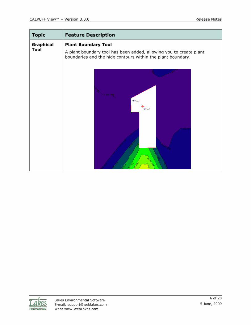
Plant Boundary Tool
A plant boundary tool has been added, allowing you to create plant
boundaries and the hide contours within the plant boundary.

CALPUFF View™ – Version 3.0.0 Release Notes
7 of 20
5 June, 2009 Lakes Environmental Software
E-mail: [email protected]
Web: www.WebLakes.com
Topic Feature Description
Graphical
Tool
Additional Delete Tools
Additional Delete tools were implemented. See the functionality of each
one of these tools below:
Point/Rectangular Delete Tool: This tool allows you to delete a
specific object or objects inside or outside a user specified rectangle.
Circular Delete Tool: This tool allows you to delete a specific object or objects inside or outside a user specified circle.
Polygonal Delete Tool: This tool allows you to delete a specific object or objects inside or outside a user specified polygon.
A new option was implemented in the Delete Objects dialog that allows
you to specify if objects to be deleted are inside or outside the shape
(rectangular, circular, or polygonal) digitized using one of the delete tools
described above.

CALPUFF View™ – Version 3.0.0 Release Notes
8 of 20
5 June, 2009 Lakes Environmental Software
E-mail: [email protected]
Web: www.WebLakes.com
Topic Feature Description
Graphical
Tool
Cross Section Tool
The Cross Section tool, located on the Annotation Toolbar, allows you
to graphically define a line segment within your modeling domain for
which you would like to view available data (e.g., terrain elevations,
concentrations). The data is displayed both in table and graph format.
Graphical
Options
Maximum Concentration Display
The maximum concentration, and its location, for the currently displayed
plot is shown at the bottom of the CALPUFF View window.

CALPUFF View™ – Version 3.0.0 Release Notes
9 of 20
5 June, 2009 Lakes Environmental Software
E-mail: [email protected]
Web: www.WebLakes.com
Topic Feature Description
Graphical
Options
Sharing User-Defined Palettes Between all Lakes Applications
Now your user-defined palettes are shared between all Lakes
Environmental applications.
General Scroll Wheel Zoom
The mouse scroll wheel zoom has been reversed so that it will zoom in if
you scroll up and will zoom out if you scroll down.
GeoPhysical
Processor
Updated GeoPhysical Processor
The Geoprocessor has been updated; some of the new features include:
� A tools menu
� Ability to specify the SW corner or the center of the met grid
� Improved File Search
� Ability to import elevations from the GEO.DAT file for objects that
were created prior to the running of the Geophysical Processor

CALPUFF View™ – Version 3.0.0 Release Notes
10 of 20
5 June, 2009 Lakes Environmental Software
E-mail: [email protected]
Web: www.WebLakes.com
Topic Feature Description
Terrain Automatic Download of SRTM, GTOPO and Canadian DEM Terrain
Data
The Geophysical Processor has been updated to allow the automated
download of Shuttle Radar Topography Mission terrain data files (SRTM)
and GTOPO30 files. The table below shows the available formats and
resolutions:
To use the automated download function press the
button to display the available terrain data file options, select the
format you wish to download. All terrain data files available for your
modeling area are automatically downloaded from Lakes Environmental
WebGIS.com and stored under the “cache_Maps” folder for future use.
Terrain File
Format
Available Free
Download
Resolution
DEM, 7.5 min USA, Canada 1 arc-sec, ~30m
DEM, 15 min Canada 2 arc-sec, ~60m
DEM, 1 deg USA 3 arc-sec, ~90m
SRTM3 – Version 2 Global 3 arc-sec, ~90m
SRTM30 Global 30 arc-sec, ~1km
SRTM1 – Version 2 USA 1 arc-sec, ~30m
GTOPO30 Global 30 arc-sec, ~900m

CALPUFF View™ – Version 3.0.0 Release Notes
11 of 20
5 June, 2009 Lakes Environmental Software
E-mail: [email protected]
Web: www.WebLakes.com
Topic Feature Description
Land Use Automatic Download of US NLCD92 and GLCC Global Land Use
Data
The Geophysical Processor has been updated to allow the automated
download of US NLCD92 and GLCC Global Land Use Data – this provides
global coverage for the land use data required to run the Geoprocessor.
Note: Using NLCD92 data for larger modeling domains may cause long
run times for the GeoProcessor

CALPUFF View™ – Version 3.0.0 Release Notes
12 of 20
5 June, 2009 Lakes Environmental Software
E-mail: [email protected]
Web: www.WebLakes.com
Topic Feature Description
CALMET Smart Option Selection for MM5
When MM5 is selected in CALMET (NOOBS = 1 or 2), other options are
automatically set to suit MM5 use:
• Use Prognostic Wind Fields is selected
• “Do Not Extrapolate” for Vertical Extrapolation of Wind Fields is
selected
• “Generate Cloud Cover from Prognostic RH” is selected
CALMET MM5 Warning
A warning message has been added when the user tries to run CALMET
without MM5 data specified (when a NOOBS value has been selected that
requires MM5).

CALPUFF View™ – Version 3.0.0 Release Notes
13 of 20
5 June, 2009 Lakes Environmental Software
E-mail: [email protected]
Web: www.WebLakes.com
Topic Feature Description
CALMET
CALPUFF
Regulatory Settings Button
The CALMET and CALPUFF Wizards now include a regulatory default
(MREG) button that will automatically apply the required regulatory
settings to the project.
CALPUFF SVMIN – Regulatory Setting
In version 5.8 of CALPUFF, the parameter SVMIN is now set to the EPA
recommend value, rather than the TRC default value.

CALPUFF View™ – Version 3.0.0 Release Notes
14 of 20
5 June, 2009 Lakes Environmental Software
E-mail: [email protected]
Web: www.WebLakes.com
Topic Feature Description
CALPOST Back/Next Buttons
Back and Next Buttons have been added to the CALPOST Options dialog.
CALPOST CALPOST Rank Values
A Warning has been added when the user tries to run CALPOST with a
rank value that is greater than what is allowed by the specified CALPOST
executable.

CALPUFF View™ – Version 3.0.0 Release Notes
15 of 20
5 June, 2009 Lakes Environmental Software
E-mail: [email protected]
Web: www.WebLakes.com
Topic Feature Description
Met
Processor
Fix (READ62) Warning
When processing upper air data in the Met Processor, if READ62 is unable
to create complete UP.DAT files the user will be prompted with a warning.
The user can then choose to proceed to Fix (Read62) to correct the
problem.
Met
Processor
Search Domain
The station search domain in the met processor is now specific to each
station type; surface, upper air and precipitation, and has been made
more visible.
Import Import Buoyant Area Sources from Excel
Buoyant area sources can now be imported from an Excel file into a
BAEMARB.DAT file. An Excel template is located in C:\Program
Files\Lakes\CALPUFF View\Templates. The import option is available from
Import | Buoyant Sources.
CALPUFF View™ – Version 3.0.0 Release Notes
16 of 20
5 June, 2009 Lakes Environmental Software
E-mail: [email protected]
Web: www.WebLakes.com
Topic Feature Description
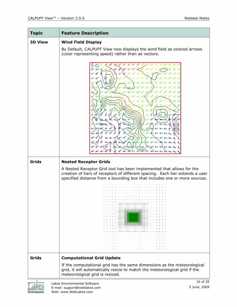
3D View Wind Field Display
By Default, CALPUFF View now displays the wind field as colored arrows
(color representing speed) rather than as vectors.
Grids Nested Receptor Grids
A Nested Receptor Grid tool has been implemented that allows for the
creation of tiers of receptors of different spacing. Each tier extends a user
specified distance from a bounding box that includes one or more sources.
Grids Computational Grid Update
If the computational grid has the same dimensions as the meteorological
grid, it will automatically resize to match the meteorological grid if the
meteorological grid is resized.

CALPUFF View™ – Version 3.0.0 Release Notes
17 of 20
5 June, 2009 Lakes Environmental Software
E-mail: [email protected]
Web: www.WebLakes.com
Topic Feature Description
Grids Center Grid on Source
It is now possible to specify a grid location using the center of the grid as
the reference point, this is includes the meteorological, nested receptor
and ring receptor grids. The center coordinate may also be chosen to
match the coordinates of an existing source.
New Project
Wizard
Automatically Process Geophysical Data
The New Project Wizard does not process geophysical data by default.
This option is still easily selected from within the Wizard.

CALPUFF View™ – Version 3.0.0 Release Notes
18 of 20
5 June, 2009 Lakes Environmental Software
E-mail: [email protected]
Web: www.WebLakes.com
Topic Feature Description
New Project
Wizard
Updated New Project Wizard
The New Project Wizard has been updated, including easier methods of
specifying your modeling domain, as well as an option to verify your
domain in Google Earth.
New Project
Wizard
Units for distances
The UTM reference point and the site domain dimensions in the New
Project Wizard can now be specified in meters or kilometers.
Help Updated Help Files
The help files for all applications within the CALPUFF View package were
updated to include the description of all new features.
Help Link To Knowledgebase
There is now a like to the CALPUFF View online knowledge base under the
Help menu.

CALPUFF View™ – Version 3.0.0 Release Notes
19 of 20
5 June, 2009 Lakes Environmental Software
E-mail: [email protected]
Web: www.WebLakes.com
Resolved Issues
Topic Issue Description
CALPUFF Incomplete Message for Output Groups
When Output Groups were selected in CALPUFF, a Project Incomplete
message would be given at run time which incorrectly stated that the
Geometric Standard Deviation must be greater than zero. This has been
corrected.
Sources Deleted Parameters when Making Sources Inactive
When making sources inactive through the source list, some source
parameters were being deleted from the source; this has been fixed.
Import Import from AERMOD Input – Hill Height Error
In some cases hill heights in an AERMOD input file were being imported
as receptor flagpole heights. Flagpole heights are now correctly
identified.
Import Imported Plot Files
Imported plot files are now shown in the CALPOST tab under their own
category, rather than replacing the existing plot files.
Buildings Tier Height Swapping
In some cases building tier heights were being swapped between tiers;
this no longer occurs.
Buildings Elevations of Buildings Imported from BPIP input files
In some cases, elevations of buildings imported from BPIP input files were
not being assigned, this has been resolved.
Sources Area Source Import
An error has been corrected where the y coordinates of area source
vertices were incorrectly imported when using the import from Excel
option.
CALMET Sub-Hour Wind Fields
Previously wind fields from CALMET.DAT files that were less than one hour
in length were not being displayed in CALPUFF View; it is now possible to
visualize these wind fields.
Models
Check
POSTUTILL.EXE Check
The Models Check tool now correctly looks for POSTUTILL.EXE rather than
POSTUTIL.EXE.

CALPUFF View™ – Version 3.0.0 Release Notes
20 of 20
5 June, 2009 Lakes Environmental Software
E-mail: [email protected]
Web: www.WebLakes.com
Topic Issue Description
CALPUFF Geometric Standard Deviation
CALPUFF View was incorrectly giving a warning when the geometric
standard deviation for species was set to zero.
New Project
Wizard
Back Button with Geographical Reference Point
If the reference point was specified in latitude and longitude, and the user
clicked Back to return to the reference point page in the New Project
Wizard, an error was given. This has been corrected.
New Project
Wizard
UTM Check
The acceptable range of UTM coordinate values has been updated.
General Decimal Places
Throughout the interface, more appropriate numbers of decimal places
are show, depending on the specific setting.
CALMET Station List Updates
The station lists on the Modules/Stations page of the CALMET Wizard are
now automatically updated each time the met processor is run.
CALMET MM5 Support
CALMET now supports more recent MM5 file formats
Wizards Restore Defaults
The restore defaults buttons found in the CALMET and CALPUFF Wizards
have been reviewed and updated to reflect the latest default values.