canada’s unresolved maritime · pdf filecanada's unresolved maritime boundaries 4.4...
TRANSCRIPT

CANADA’S UNRESOLVED MARITIME BOUNDARIES
J. K. RENOUF
January 1988
TECHNICAL REPORT NO. 134

PREFACE
In order to make our extensive series of technical reports more readily available, we have scanned the old master copies and produced electronic versions in Portable Document Format. The quality of the images varies depending on the quality of the originals. The images have not been converted to searchable text.

CANADA'S UNRESOLVED MARITIME BOUNDARIES
J. Keith Renouf
Department of Surveying Engineering University of New Brunswick
P.O. Box 4400 Fredericton, N.B.
Canada E3B5A3
January 1988

CANADA'S UNRESOLVED MARITIME BOUNDARIES
ABSTRACT
The resolution of offshore boundary disputes must first be attained before managed
development of the offshore region under dispute may begin. Presently, Canada
shares maritime boundaries with Denmark, France and the United States. An
examination of these offshore boundaries shows that only the maritime boundary
between Denmark and Canada and the boundary off the Juan de Fuca Strait between
Canada and the United States offer an area of little or no conflict. The other unresolved
boundaries are disputed as the states concerned hold different positions regarding the
delimitation of the offshore boundary lines.
A negotiated or adjudicated settlement to these boundaries must consider the
history, the existing legal precedents for offshore boundary determination, the
customary law involved and each state's interests, however varied they may be. It is
only after careful consideration of these facts that an equitable boundary solution will
be found. Without drawing conclusions on what the final boundary will be in each
instance, this paper presents an analysis on each of Canada's unresolved boundaries.
In addition to presenting the historical background on each boundary and arguments
for certain boundary delimitations, the urgency attached to finding a boundary
agreement is reviewed and a comparison attempted with the recent Gulf of Maine
decision.
Overall, the paper incorporates past and present events to give a detailed analysis of
the situation regarding Canada's unresolved offshore boundaries.
iii
CANADA'S UNRESOLVED MARITIME BOUNDARIES
TABLE OF CONTENTS
Abstract
Table of Contents
List of Figures
Acknowledgements .
1.0 Introduction
2.0 Zones of Delimitation
3.0 U.S.-Canada Maritime Boundary : Beaufort Sea
3.1 Beaufort Sea Layout .
3.2 Historical Background
3.3 Boundary Delimitation Solutions
3.3.1 The Sector Theory . .
3.3.2 The Grisbadarna Principle
3.3.3 Equidistance
3.4 Settlement Urgency
3.5 Gulf of Maine Comparison
4.0 Denmark-Canada Maritime Boundary : Davis Strait, Baffin Bay
and Nares Strait
4.1 Area Under Consideration
4.2 Historical Background
4.3 Boundary Delimitation Solutions
iv
Page
111
lV
Vll
viii
1
3
9
11
13
18
18
22
23
25
27
31
31
34
36

CANADA'S UNRESOLVED MARITIME BOUNDARIES
4.4 Settlement Urgency 37
5.0 France-Canada Maritime Boundary : Saint Pierre et Miquelon 39
5.1 Coastal Configuration and Layout . 39
5.2 Historical Background 42
5.3 Boundary Delimitation Solutions 48
5.3.1 Pure Equidistance Principle 49
5.3.2 Treatment as an Enclave . . 51
5.3.3 Previous Island Agreements 55
5.4 Settlement Urgency 58
5.5 Gulf of Maine Comparison 59
6.0 U.S.-Canada Maritime Boundary: Outer Georges Bank and Machias
Seal Island . . . . 61
6.1 Gulf of Maine Layout 62
6.2 Historical Background 64
6.3 Possible Boundary Solutions 68
6.4 Settlement Urgency 70
6.5 Gulf of Maine Comparison 71
7.0 U.S.-Canada Maritime Boundary: Juan de Fuca Strait 73
7.1 The Juan de Fuca Strait Region 73
7.2 Historical Background 76
7.3 A Solution to the Boundary Delimitation 78
7.4 Settlement Urgency 79
7.5 Gulf of Maine Comparison 80
8.0 U.S.-Canada Maritime Boundary : Dixon Entrance 83
8.1 Coastal Configuration and Offshore Layout 83
v

CANADA'S UNRESOLVED MARITIME BOUNDARIES
8.2 Historical Background
8.3 Boundary Delimitation Solutions
8.4 Settlement Urgency
8.5 Gulf of Maine Comparison
9.0 Conclusions
References
Appendix A
AppendixB
vi
86
92
94
95
97
103
107
113

CANADA'S UNRESOLVED MARITIME BOUNDARIES
LIST OF FIGURES
Page
Figure 2.1 Canada's Remaining Unresolved Boundaries 4
Figure 2.2 Zones of Delimitation . . . . . . . . 7
Figure 3.1 International Boundary Along the 141st Meridian 10
Figure 3.2 Beaufort Sea Layout . . . . . . . . . . 12
Figure 3.3 North Circumpolar Regions: Sector Theory Applications 21
Figure 3.4 North Sea Continental Shelf Boundaries 24
Figure 3.5 Gulf of Maine - ICJ Boundary Delimitation 28
Figure 4.1 1973 Canada - Denmark Equidistant Boundary 32
Figure 5.1 St. Pierre et Miquelon Equidistance Offshore Boundary 41
Figure 5.2 1972 Mutual Fisheries Agreement Boundary . . . . 45
Figure 5.3 Continental Shelf Boundary Between France and England 52
Figure 6.1a Present Boundary Claims : Bay of Fundy 63
Figure 6.1 b Modified Equidistant Boundary . . . 63
Figure 6.2 Outer Continental Shelf- Georges Bank Boundary 65
Figure 7.1 Juan de Fuca Strait Offshore Region . . . . . 75
Figure 7.2 U.S. -Canada Maritime Boundary : Juan de Fuca Strait 77
Figure 8.1 Dixon Entrance Offshore Region . . . . 85
Figure 8.2 U.S. - Canada Boundary in Dixon Entrance 88
vii
CANADA'S UNRESOLVED MARITIME BOUNDARIES
ACKNOWLEDGEMENTS
This technical report was originally written as a research paper for Dr. John
McLaughlin; the author can only thank him for his patience as the work was
researched and written. Also, I would like to thank Ms. Sue Nichols for her help
throughout the writing of this research paper. This topic was of immense personal
interest to myself and I appreciate all the support provided by my supervisor, Dr.
Wells.
Financial assistance for this work was provided by a Natural Sciences and
Engineering Research Council of Canada Strategic Grant entitled "Marine Geodesy
Applications" held by Dr. D.E. Wells, Dr. P. Vanicek and Dr. R. Langley. Also,
assistance was provided by the University of New Brunswick. I am grateful for this
help.
Finally, I am indebted to my wife Michele for her patient proofreading and support.
viii
CANADA'S UNRESOLVED MARITIME BOUNDARIES
1.0 INTRODUCTION
The delimitation of maritime boundaries between neighbouring states has grown more
complex as they have pushed their zones of jurisdiction further from shore. For
Canada, this has meant the expansion of its maritime jurisdiction to include all the
adjacent continental shelf with the exception of the Flemish Cap on the Grand Banks.
In delimiting the boundaries under Canada's jurisdiction, there exist specific areas
where Canada shares a maritime boundary with either an adjacent or opposite state.
Since the expansion of offshore jurisdiction is relatively new in terms of establishing
global boundaries, offshore boundary claims by an individual state almost always
conflict with those of a neighbouring state.
There are eight offshore areas over which Canada must establish a maritime
boundary with a neighbouring state. Although these are not all in dispute, the
boundary conflicts that exist are sensitive issues as they pertain to national sovereignty
and the right to explore for and exploit various resources. "In addition to harvesting
the living resources of the sea, the past thirty years have seen rapid advances in
offshore technology which have facilitated the exploitation of offshore diamonds,
placer-gold, manganese nodules, aggregates, oil and natural gas" (Mills, 1971). Thus,
any offshore boundary agreement between Canada and a neighbouring state delineates
more than just marine jurisdiction.
This paper examines each of Canada's unresolved offshore boundaries with an
initial overview of the area, both coastal and offshore, and the zones of jurisdiction
Chapter 1: Introduction Page: 1

CANADA'S UNRESOLVED MARITIME BOUNDARIES
requiring a boundary settlement. This is done for the four maritime boundaries shared
with the United States in the Beaufort Sea, in the Gulf of Maine, off the Juan de Fuca
Strait and off Dixon Entrance. Also, a similar presentation is made for the Denmark -
Canada boundary and the France - Canada boundary surrounding Saint Pierre and
Miquelon.
After introducing the area of concern, a chronological sequence of events that
contribute to the history of each boundary is attempted prior to discussing possible
boundary solutions. Arguments both for and against a particular boundary delimitation
are given in analyzing each solution as well as the particular state's position on that
solution.
For each boundary, an attempt is made at determining the urgency with which a
solution should be found and the reasons for this urgency. Finally, a comparison is
made of the judicial issues that decided the Gulf of Maine boundary, as defined by the
International Court of Justice, and similar judicial issues existing for the unresolved
boundaries. For the sake of completeness, each boundary is examined individually.
Page: 2 Chapter 1: Introduction

CANADA'S UNRESOLVED MARITIME BOUNDARIES
2.0 ZONES OF DELIMITATION
The Third United Nations Convention on the Law of the Sea (UNCLOS III)
formalized an international agreement on the limits of the territorial sea, the contiguous
zone, the exclusive economic zone (EEZ) and the continental shelf. Although covering
a wide range of issues on the law of the sea, the importance of UNCLOS III in
promoting the peaceful solution of maritime boundary settlements over these zones is
stressed.
With respect to Canada, there are certain offshore zones that have, or else require,
an adjacent or opposite state agreement between Canada and its neighbours for the
purposes of delimiting the maritime boundary (Figure 2.1). A single boundary
agreement that covers all four zones could provide an ideal solution for certain cases.
These zones are seen as the foundation to any states legitimate claim to extended
offshore sovereignty.
The limits of each zone and the associated rights possessed by the state have been
addressed by UNCLOS III and are contained within the Convention. The text that
finally emerged from UNCLOS III (United Nations, 1983):
establishes a comprehensive framework for the regulation of all the ocean space. It is divided into 17 parts and nine annexes, and contains provisions governing, inter alia, the limits of natural jurisdiction over ocean space, access to the high seas, navigation, protection and preservation of the marine environment, exploitation of living resources and conservation, scientific research, sea-bed mining and other exploitation of non-living resources, and the settlement of disputes.
Chapter 2: Zones of delimitation Page: 3

~ lT}f~~~~ffiJ.!:~f&NiJ ~ (10
~
"""I ..l-·:.:;:::1 ::--· -
~· ~ '"@ .. "'"1
n :r I" '0 (b ..... !':>
~ !}; 0 ....,
~ ~: ~ g'
~:
;,-,J f II
.J ~· .__\ -~. -
J
w ~ 0~
(:) 0
t? '\ ).
··t ~~!'II!~r,.,.,.
r ·~~. -.. &_
Figure 2.1
Canada's Remaining Unresolved Boundaries
]:%h
BY
~
~ ......
······~······~:; ,•
~· .~vA¥1~ ~J? ~ ,
..•.... }~'"
"' I' .... --E '~
(')
> z > t::' ~ c;n
~
~ ['!j c;n 0 t"" < ['!j t::'
3: > '=' a 3: ['!j
= 0 ~
~ > '=' ...... ['!j c;n

CANADA'S UNRESOLVED MARITIME BOUNDARIES
Although an active participant in the negotiations on the Law of the Sea, Canada has
not ratified the agreement. Yet, Canada is a signatory of both the Convention and Final
Act and thus may be delaying ratification for political reasons.
In attempting to examine the unresolved boundaries of Canada, a definition of the
zones which require settlement in each situation is first presented. As a legal definition
for each zone, the description and extent of the zone is taken from the UNCLOS III
convention.
The territorial sea of each state extends from the baselines of the state outward to a
limit not exceeding 12 nautical miles. The area contained within the territorial sea is
under the sovereign rule of the coastal state with sovereignty extending to the air space
over the territorial sea as well as to its bed and subsoil (art. 2, United Nations, 1983).
Presently, Canada claims a 12 nm territorial sea as well as Denmark and France with
the United States holding to the old 3 nm limit.
The contiguous zone is described as a zone contiguous to the territorial sea over
which the coastal state does not have full sovereignty but may exercise control
necessary to:
• prevent infringement of its customs, fiscal, immigration or sanitary laws and regulations within its territory or territorial sea;
• punish infringement of the above laws and regulations committed within its territory and territorial sea (art. 33, United Nations, 1983).
The contiguous zone extends a distance of 24 nm from the baselines used to measure
the territorial sea. An analysis of the boundary between Canada and its neighbours
over the contiguous zone is neglected. It is accepted that any boundary settlement that
covers the EEZ or continental shelf will also delimit the contiguous zone.
The establishment of the EEZ is a direct result of coastal states extending their
jurisdiction over the sea and sea bed for the purposes of exploiting and managing both
Chapter 2: Zones of delimitation Page: 5

CANADA'S UNRESOLVED MARITIME BOUNDARIES
the living and non-living resources. The specific legal regime of the EEZ is specified
within the UNCLOS III convention and pertains to the actual sovereign rights and
areas of jurisdiction of the coastal state. For boundary delimitation purposes, the
breadth of the EEZ is established as an area not extending beyond 200 nm from the
baselines from which the breadth of the territorial sea is measured (art. 57, United
Nations, 1983). The UNCLOS III convention has specified methods for the
delimitation of the EEZ boundary between opposite and adjacent states (art 74, United
Nations, 1983) that will lead to an equitable solution. Also, the convention has
described methods for delimiting the EEZ boundary. The actual text of the convention
relating to these last two points is contained in Appendix A. The EEZ is accepted by
Canada, Denmark, France and the United States as a legal extension of the coastal
states jurisdiction.
Finally, there is the continental shelf between opposite and adjacent states that
requires an equitable boundary solution. For the purposes of delimiting the continental
shelf, the UNCLOS III convention provided for solutions based on either the
thickness of sedimentary rocks, distance from the foot of the continental slope,
distance from the baselines of the state and distance from a specific contour depth.
Again, the actual text defining the continental shelf, a state's rights over the shelf and
methods of delimiting the shelf between opposite or adjacent states is contained in
Appendix A. Canada, Denmark, France and the United States all support and
recognize the state's interests in and upon the continental shelf.
These four zones (Figure 2.2) have quickly become entrenched within customary
international law. The delimitation of boundaries over these zones has also been
accepted, but the methods used have been as diverse as the zones themselves with both
negotiated and arbitrated boundary settlements employing different methods to
Page:6 Chapter 2: Zones of delimitation

CANADA'S UNRESOLVED MARITIME BOUNDARIES
adequately deal with the specific circumstances of each case. An analysis of Canada's
boundaries that have yet to be delimited over these zones is now attempted on a
boundary by boundary basis.
1 2 nm
Territorial Sea
24 nm
Figure 2.2
Chapter 2: Zones of delimitation
Exclusive Economic Zone
200 nm
Geological Rise
??? Shel'-f __ n_.~.
Oceanic Crust
Zones of Delimitation
after: Hodgson & Smith (1979)
Page:7

CANADA'S UNRESOLVED MARITIME BOUNDARIES
Page: 8 Chapter 2: Zones of delimitation

CANADA'S UNRESOLVED MARITIME BOUNDARIES
3.0 U.S. - CANADA MARITIME BOUNDARY:BEAUFORTSEA
The United States and Canada share a maritime boundary in the Beaufort Sea that
extends seaward from boundary monument #1 near Demarcation Point (Figure 3.1).
Outside of agreeing on the beginning point of the boundary (i.e. boundary monument
#1), both states dispute the other's boundary claim as to the seaward extension of the
land boundary. The settlement of this boundary remains as one of the major boundary
issues between Canada and the United States, with both sides holding widely differing
views. Canada maintains that the boundary was established as the 141 st meridian
during the 1903 Alaska boundary arbitration; the United States has countered that the
boundary follows an equidistant line from the Yukon and Alaska coastlines.
This chapter examines the Beaufort Sea boundary in light of these two positions
and the territory involved. Beginning with a review of the territory requiring
settlement, the historical events that have contributed to each state's position are
presented. Arguments toward possible solutions and scenarios are presented in light
of recent International Court of Justice (ICJ) decisions, recognized international law
and socio-economic conditions. Finally, the technical aspects and resources available
for delineating the boundary or supporting a position are introduced and discussed.
Chapter 3: U.S.- Canada maritime boundary: Beaufort Sea Page:9

CANADA'S UNRESOLVED MARITIME BOUNDARIES
I
MONUMENT 1
I I
I
I
Figure 3.1 : International Boundary Along the 141st Meridian
I
I
Page: 10 Chapter 3: U.S. -Canada maritime boundary : Beaufort Sea

CANADA'S UNRESOLVED MARITIME BOUNDARIES
3.1 BEAUFORT SEA LAYOUT
Each of the offshore zones that may be claimed in the Arctic region of the Beaufort Sea
requires that the boundary between Canada and the United States be extended
seaward. This applies from the territorial sea all the way out to the limits of the
continental shelf and thus covers all of the zones defined by UNCLOS III.
Geographically, the offshore region may be divided three ways (Figure 3.2); first,
there is a continuous unbroken coastline that forms a shallow concave bowl orientated
in an east south-east direction. From here, the Beaufort Shelf extends to the 200 metre
contour. Thereafter, the topography follows the Beaufort Slope down to the Canadian
Basin.
An examination of the features in the region, either coastal or offshore, on either
side of the 141st meridian show an absence of any kind of major geographical
anomaly. The coastal configuration on the Canadian side of the 141 st meridian extends
to the east as far as Herschel Island with no offshore islands in between. The location
of construction basepoints may be constrained as far east as Herschal Island due to the
nature of the coastline forming McKenzie Bay beginning at Herschal Island. Although,
on the Tuktoyaktuk Peninsula basepoints may be used to generate an equidistant line.
On the Alaska side of the 141 st meridian, the coastline remains very regular, although
there are numerous offshore islands present. As the islands tend to be close to shore,
with a narrow elongated shape oriented in the direction of the coastline, they do not
disfigure the coastal pattern established by the land. In this manner the islands are a
natural prolongation of the land. For line construction purposes Pt. Barrow is the most
westerly basepoint position.
Chapter 3: U.S.- Canada maritime boundary: Beaufort Sea Page: 11

CANADA'S UNRESOLVED MARITIME BOUNDARIES
Figure 3.2 : Beaufort Sea Layout
Page: 12 Chapter 3: U.S. -Canada maritime boundary : Beaufort Sea

CANADA'S UNRESOLVED MARITIME BOUNDARIES
Figure 3.2 shows Tuktoyaktuk, NWT as the only town within this remote part of
the world. Even then Tuktoyaktuk is still 339 km from boundary monument# 1. A
settlement on Herschal Island has now been abandoned. On the American side of the
141St meridian Pt. Barrow, Alaska, is the nearest community at a distance of 585
kilometres. This leaves just two communities, one town on the Canadian side and one
on the U.S. side for the region. The fact that a population base is non-existent in the
area will be followed-up on later.
The continental shelf topography out to the 200 m contour is consistent off both
nations' coastlines, although the 50 m contour does extend almost twice as far off
Alaska than it does off the Yukon, but again this is not a disrupting circumstance.
Lying west of the 141st meridian, this anomaly is not within the disputed area.
3.2 HISTORICAL BACKGROUND
The major events that contribute to the present legal definition of the area's boundaries
may be considered more easily if viewed in the context of nineteenth century European
politics. It was agreements between the three major states with concerns in the region,
i.e. Great Britain, Russia and the United States, that determined the extent of current
possessions. Also, within these agreements lie the issues that confront negotiators and
possibly future arbitrators who attempt to define a legal boundary extension.
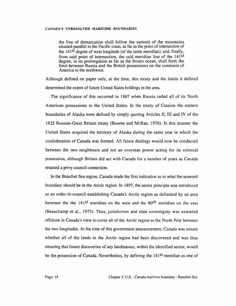
In 1825 Russia and Great Britain signed a treaty covering the territory of Alaska
that limited the expansion of Russia southwards and defmed the possessions of each
state. The boundary to the Beaufort Sea was defined in Article III of the treaty as
(Bourne and McRae, 1976):
Chapter 3: U.S.- Canada maritime boundary: Beaufort Sea Page: 13
CANADA'S UNRESOLVED MARITIME BOUNDARIES
the line of demarcation shall follow the summit of the mountains situated parallel to the Pacific coast, as far as the point of intersection of the 141 st degree of west longitude (of the same meridian); and, finally, from said point of intersection, the said meridian line of the 141 st degree, in its prolongation as far as the frozen ocean, shall form the limit between Russia and the British possessions on the continent of America to the northwest.
Although defined on paper only, at the time, this treaty and the limits it defined
determined the extent of future United States holdings in the area.
The significance of this occurred in 1867 when Russia ceded all of its North
American possessions to the United States. In the treaty of Cession the eastern
boundaries of Alaska were defined by simply quoting Articles II, III and IV of the
1825 Russian-Great Britain treaty (Bourne and McRae, 1976). In this manner the
United States acquired the territory of Alaska during the same year in which the
confederation of Canada was formed. All future dealings would now be conducted
between the two neighbours and not an overseas power acting for its colonial
possession, although Britain did act with Canada for a number of years as Canada
retained a privy council connection.
In the Beaufort Sea region, Canada made the first indication as to what the seaward
boundary should be in the Arctic region. In 1897, the sector principle was introduced
as an order-in-council establishing Canada's Arctic region as delimited by an area
between the the 141st meridian on the west and the 6Qth meridian on the east
(Beauchamp et al., 1973). Thus, jurisdiction and state sovereignty was extended
offshore in Canada's view to cover all of the Arctic region to the North Pole between
the two longitudes. At the time of this government announcement, Canada was unsure
whether all of the lands in the Arctic region had been discovered and was thus
ensuring that future discoveries of any landmasses, within the identified sector, would
be the possession of Canada. Nevertheless, by defining the 141 st meridian as one of
Page: 14 Chapter 3: U.S.- Canada maritime boundary: Beaufort Sea

CANADA'S UNRESOLVED MARITIME BOUNDARIES
the boundaries, Canada was extending its sovereignty over an area that would later
prove to be part of the Arctic Ocean.
Further use of the 141 st meridian as the international boundary between Canada and
Alaska occurred in 1898 with the creation of the Yukon territory. The eastern
boundary of the Yukon territory was described as (Beauchamp et al., 1973):
beginning at the intersection of the 141 st meridian of west longitude from Greenwich with a point on the coast of the Arctic Sea, which is approximately 69. 39', and named on the Admiralty charts, "Demarcation Point", thence due south on said meridian (which is also the boundary line between Canada and Alaska) for a distance . . .
It would seem then, that by the end of the nineteenth century Canada had accepted the
141 st meridian as the land boundary between itself and the United States in this area.
Although an acceptance of the 141 st meridian as the international boundary for part of
the Alaska-Canada border would seem achieved at this point, a dispute did arise that
required an arbitrated decision as to what the Alaska-Canada land boundary truly was.
On 20 October 1903, a decision was rendered by the Alaska Boundary Tribunal that
is seen as accepting the 141st meridian as the westward boundary. This tribunal was
established by Great Britain/Canada and the United States through a convention to
resolve the whole Alaska boundary issue. Throughout the hearings it was clear that the
141 st meridian was accepted by all as the westward limit of Alaska and the wording of
the Anglo-Russian agreement of 1825, i.e. "as far as the frozen Ocean", gave rise to
no dispute with respect to the northward extension of this line (Beauchamp et al.,
1973). The land boundary was subsequently surveyed and monumented in 1906 with
the beginning point of the boundary, boundary monument #1, established on the coast
of the Beaufort Sea (Figure 3.1).
Thus, following Canada's endorsement of the sector principle as the maritime
boundary in the Beaufort Sea, there does not seem to have been any concerted effort to
Chapter 3: U.S.- Canada maritime boundary: Beaufort Sea Page: 15
CANADA'S UNRESOLVED MARITIME BOUNDARIES
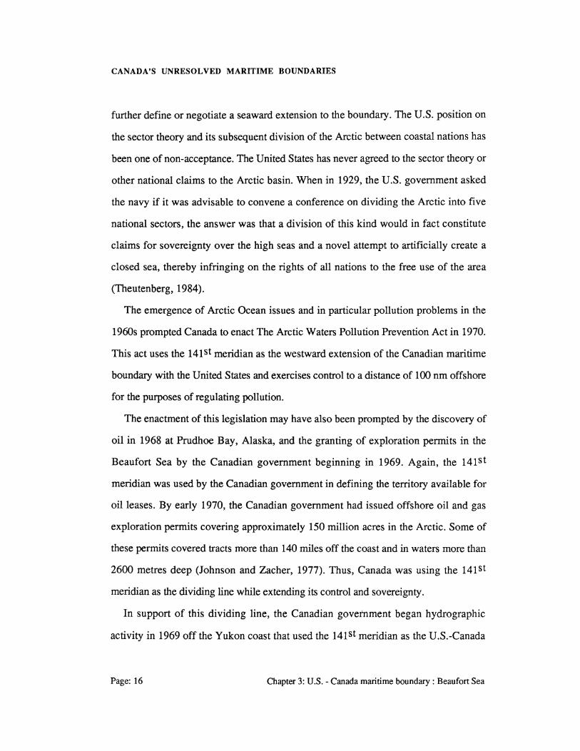
further define or negotiate a seaward extension to the boundary. The U.S. position on
the sector theory and its subsequent division of the Arctic between coastal nations has
been one of non-acceptance. The United States has never agreed to the sector theory or
other national claims to the Arctic basin. When in 1929, the U.S. government asked
the navy if it was advisable to convene a conference on dividing the Arctic into five
national sectors, the answer was that a division of this kind would in fact constitute
claims for sovereignty over the high seas and a novel attempt to artificially create a
closed sea, thereby infringing on the rights of all nations to the free use of the area
(Theutenberg, 1984).
The emergence of Arctic Ocean issues and in particular pollution problems in the
1960s prompted Canada to enact The Arctic Waters Pollution Prevention Act in 1970.
This act uses the 141 st meridian as the westward extension of the Canadian maritime
boundary with the United States and exercises control to a distance of 100 nm offshore
for the purposes of regulating pollution.
The enactment of this legislation may have also been prompted by the discovery of
oil in 1968 at Prudhoe Bay, Alaska, and the granting of exploration permits in the
Beaufort Sea by the Canadian government beginning in 1969. Again, the 141St
meridian was used by the Canadian government in defining the territory available for
oil leases. By early 1970, the Canadian government had issued offshore oil and gas
exploration permits covering approximately 150 million acres in the Arctic. Some of
these permits covered tracts more than 140 miles off the coast and in waters more than
2600 metres deep (Johnson and Zacher, 1977). Thus, Canada was using the 141St
meridian as the dividing line while extending its control and sovereignty.
In support of this dividing line, the Canadian government began hydrographic
activity in 1969 off the Yukon coast that used the 141 st meridian as the U.S.-Canada
Page: 16 Chapter 3: U.S.- Canada maritime boundary: Beaufort Sea
CANADA'S UNRESOLVED MARITIME BOUNDARIES
boundary. This policy was used as recently as 1984-85 with the tendering of a multi
purpose hydrographic and geological program off the Yukon coast that acknowledged
the 141 st meridian as a boundary line in delimiting the work area for the contract.
With the conclusion of UNCLOS III in 1983, the positions of Canada and the
United States toward their zones of offshore sovereignty and jurisdiction have an
indirect influence on the Beaufort Sea line of delimitation. As was seen in Chapter 2.0,
the articles of UNCLOS III are now becoming recognized within intemationallaw.
Thus, any boundary extension that is going to be defined over the offshore zones in
this region must have the zones defined through prior notice. In the case of Canada
this could be seen as being achieved with its prior historical stance on the 141St
meridian plus the area to its east, and its endorsement of UNCLOS lli. As mentioned
previously, the United States voted against the UNCLOS lli agreement but this could
really be seen as indifferent to its position on offshore zones. The Truman
Proclamation of 1945 and President Reagan's proclaimed 200 nm exclusive economic
zone of 1983 would seem to indicate the true United States position. In announcing the
Economic Zone Proclamation, President Reagan reiterated that many of the non-seabed
regime aspects of the Law of the Sea (LOS) convention were acceptable, and that
much of the LOS convention relating to these issues, in particular the exclusive
economic zone, had emerged as customary international law (MacDorman, 1984).
It would seem that to this point only Canada's position on the Beaufort Sea dividing
line has been reviewed, without a precise statement of the U.S. view given. It has
been shown however that the United States does not agree with the Canadian view that
the sector theory should be applied with the application of the equidistant solution
surely more suitable to U.S. claims. Recently, the United States has said that
beginning in January, 1988, it plans to offer parcels of offshore lands to U.S.
Chapter 3: U.S.- Canada maritime boundary: Beaufort Sea Page: 17

CANADA'S UNRESOLVED MARITIME BOUNDARIES
exploration companies within an area claimed by Canada east of the 141 st meridian.
The basis of this is the United States belief that the territory is American based on the
equidistance principle. Thus a dispute left simmering may now be coming to maturity.
3.3 BOUNDARY DELIMITATION SOLUTIONS
The possible solutions to the Beaufort Sea boundary may initially be seen as either an
adoption of the 141 st meridian or an equidistant line. Yet, there also exists the chance
that some form of a modified equidistant line may be implemented. This section
examines the possible solutions and arguments, both for and against, in regard to the
various boundary line implementations. An analysis is done of the sector theory, the
equidistant line, the Grisbadarna principle and the urgency of finding a solution.
Finally, a comparison is performed with the recent Gulf of Maine decision.
3.3.1 The Sector Theory
Originally proposed in 1897 for Canada's Arctic region (Section 3.2), the sector
theory is a method for delimiting an area claimed by a state. The theory consists of
land claims being made on the basis of the land within a sector defined by the
delimitation of longitudes from points below the pole to the pole itself, resulting in a
pie shaped division of territory. Within the north circumpolar region Canada and
Russia are the only countries that have applied the sector theory as a basis of their land
and maritime claims (Figure 3.3). Although applied in the past as a means of gaining
Page: 18 Chapter 3: U.S.- Canada maritime boundary: Beaufort Sea

CANADA'S UNRESOLVED MARITIME BOUNDARIES
sovereignty over the islands of the Arctic archipelago, the theory is now being applied
to maritime areas such as the exclusive economic zone and the continental shelf.
From the beginning of the century Canadian maps have shown a Canadian sector
going from the country's western border along the 141St longitude west and from the
eastern border along the 6oth longitude west up to the pole (Theutenberg, 1984). As a
means of identifying Canada's northern international boundary, these same lines of
delimitation are shown on the most recent maps available from the Canadian
department of Energy, Mines and Resources (Energy, Mines and Resources Canada,
1985) and the Canada Oil and Gas Lands Administration (COGLA, 1985). Canadian
government support of the sector theory as a means of defining the EEZ and
continental shelf boundaries can only be seen as increasing. In 1969 Prime Minister
Trudeau added that he believed the sector principle to apply to the sea-bed and the
continental shelf, but not to the water and ice (Theutenberg, 1984). This view of the
sector theory does not conflict with the earlier view by the United States that the sector
theory could not be used to enclose the high seas as only the zones of UNCLOS III
would be defined with this principle.
Yet, the view proposed by then Prime Minister Trudeau does allow for two distinct
offshore boundaries being determined. This would then have the 141st meridian as the
continental shelf boundary, with another line possibly delimiting the fisheries zone or
exclusive economic zone.
Internationally, the Soviet Union has adopted the sector theory, at least in literature,
where Soviet writers refer to the Soviet northern seas as the entire Soviet sector up to
the North Pole (Theutenberg, 1984). This sector of the Arctic is considered as
historical waters to which the Soviets have a historical right, created by the Russian
people's industrious work during several centuries. A second Russian reference
Chapter 3: U.S.- Canada maritime boundary: Beaufort Sea Page: 19
CANADA'S UNRESOLVED MARITIME BOUNDARIES
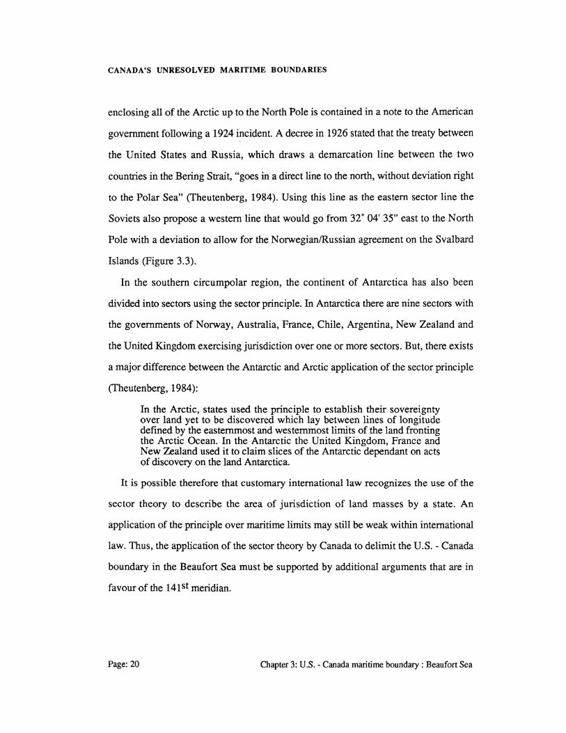
enclosing all of the Arctic up to the North Pole is contained in a note to the American
government following a 1924 incident. A decree in 1926 stated that the treaty between
the United States and Russia, which draws a demarcation line between the two
countries in the Bering Strait, "goes in a direct line to the north, without deviation right
to the Polar Sea" (Theutenberg, 1984). Using this line as the eastern sector line the
Soviets also propose a western line that would go from 32• 04' 35" east to the North
Pole with a deviation to allow for the Norwegian/Russian agreement on the Svalbard
Islands (Figure 3.3).
In the southern circumpolar region, the continent of Antarctica has also been
divided into sectors using the sector principle. In Antarctica there are nine sectors with
the governments of Norway, Australia, France, Chile, Argentina, New Zealand and
the United Kingdom exercising jurisdiction over one or more sectors. But, there exists
a major difference between the Antarctic and Arctic application of the sector principle
(Theutenberg, 1984):
In the Arctic, states used the principle to establish their sovereignty over land yet to be discovered which lay between lines of longitude defined by the easternmost and westernmost limits of the land fronting the Arctic Ocean. In the Antarctic the United Kingdom, France and New Zealand used it to claim slices of the Antarctic dependant on acts of discovery on the land Antarctica.
It is possible therefore that customary international law recognizes the use of the
sector theory to describe the area of jurisdiction of land masses by a state. An
application of the principle over maritime limits may still be weak within international
law. Thus, the application of the sector theory by Canada to delimit the U.S. - Canada
boundary in the Beaufort Sea must be supported by additional arguments that are in
favour of the 141 st meridian.
Page:20 Chapter 3: U.S.- Canada maritime boundary: Beaufort Sea

g ~ & x> c: tn
I
('}
l a ~§· (1>
g ! .. tP (1>
~ 0' ~ en g
"0
~ t>) ,...
0
A o ~~:::::::. o u ··::::···· ·.;.:: ..
&
D ~/
~ ~
~ ~
~
RUSSIAN ARCTIC SECTOR
/--- /
----- /, CANADIAN
" ARCTIC SECTOR /
~
~~ ~
~ /
.. ~ o{§J SVALBARD 1illf, ISLANDS
Figure 3.3 : North Circumpolar Regions: Sector
Theory Applications

CANADA'S UNRESOLVED MARITIME BOUNDARIES
3.3.2 The Grisbadarna Principle
Support for the sector theory and hence the 141St meridian as the dividing line on
behalf of Canada may be derived from an aspect of international law known as the
Grisbadama Principle. This principle originated from a dispute between Norway and
Sweden settled by the Permanent Court of Arbitration that decided the maritime
boundary between the two countries over the Grisbadama lobster bank.
The decision rendered by the arbitrator's statement became known as the
Grisbadama Principle and may be stated as (Lagoni, 1979):
it is a settled principle of the law of nations that a state of things which actually exists and has existed for a long time should be changed as little as possible; and this rule is especially applicable in a case of private interests which, if once neglected, cannot be effectively safeguarded by any manner of sacrifice on the part of the government of which the interested parties are subjects.
One application of this may be seen in the United States acquiescence to the
historical claim of Canada's use of the sector principle. This is supported on Canada's
part by its hydrographic work in the area and its granting of oil and gas leases for the
area. Although no actual exploration work has been performed by a Canadian operator
within the offshore region under dispute, there is exploration activity occurring to the
east off the Yukon coast.
Outside of the Norway-Sweden arbitration, the Grisbadama Principle has been
applied by West Germany and Denmark. When these two countries re-delimited
certain areas of the continental shelf in the North Sea in compliance with the
International Court of Justice's decision, a certain area where drilling operations had
been conducted by Danish concessionaires was retained by Denmark, although from a
strictly geographical point of view it should have been allotted to Germany (Figure
3.4). Apparently, the determining factor was the Grisbadama Principle rather than the
Page:22 Chapter 3: U.S. - Canada maritime boundary : Beaufort Sea

CANADA'S UNRESOLVED MARITIME BOUNDARIES
unity of the deposit, because only promising traces but no definite deposit of oil and
gas had been discovered in that area at the time of the delimitation (Lagoni, 1979).
With these applications, the Grisbadarna Principle is considered established within
international law. Thus, Canada could have a possible case for using this principle
within the context of the 141 st meridian. As an argument, the Grisbadama Principle is
relevant should the boundary dispute go before a court of arbitration or be negotiated.
3.3.3 Equidistance
If the United States is not going to accept the sector theory and its associated 141st
meridian then it would have to be presumed that its position would favour that of an
equidistance principle. A line drawn off the Beaufort coast in accordance with this
principle is shown in Figure 3.1. Although this line would not favour Canada, it is
definitely advantageous to the United States to support its implementation. The
establishment of a line by the equidistant principle is seen as technically simple for
construction purposes, while at the same time having arguable points in its favour.
The shape of the coastline has already been described as concave with an azimuth of
approximately 120 degrees. Its orientation plus the lack of any irregular topographical
features along the coastline or offshore (Figure 3.2), offer an easily constructed line
from the selected basepoints. The lack of a coastal population on either side of the
Yukon or Alaska border, plus the absence of a socio-economic base that would result
from this population also contribute to making the equidistant line a simply constructed
one. This is due to the fact that no proportioning has to be done to account for
variances in the populations and coastline lengths.
Chapter 3: U.S.- Canada maritime boundary: Beaufort Sea Page: 23

CANADA'S UNRESOLVED MARITIME BOUNDARIES
Page:24
GRISBAOARNA PRINCIPLE
APPLIED
UNITED KINGDOM
Figure 3.4 : ICJ North Sea Continental Shelf Boundaries AFTER: HODGSON & SMITH {1979)
Chapter 3: U.S.- Canada maritime boundary: Beaufort Sea
CANADA'S UNRESOLVED MARITIME BOUNDARIES
The application of the equidistant line is fully accepted as an equitable solution by
international law. Thus, its proposal by the United States as the maritime boundary
does seem fitting. For Canada, its prior treaty with Denmark using an equidistant line
and its support of the equidistant line for two of the other three U.S. boundaries, i.e.
Dixon Entrance and Juan de Fuca Strait, show that this country fully recognizes the
equidistant principle.
If neither the 141 st meridian or equidistant line are adopted than a possible solution
would be the rotation of a geodesic line about the beginning point, boundary
monument #1. This type ofline would be a compromise on the part of both states, but
may be the only equitable solution to the dispute. The actual location of such a line and
its supporting arguments may lie only in the art of negotiation where both states would
give a little to reach a compromise. The amount of area that lies between the 141St
meridian and an equidistant line has been calculated as approximately 31,137 square
kilometres. A dividing line giving equal area, within the disputed area, to both states
could be this compromise line. With such a considerable portion of territory involved,
the final resolution of the boundary depends on the urgency of the governments to
come to an agreement.
3.4 SETTLEMENT URGENCY
An analysis of the major Beaufort Sea factors that could press for the solution of this
boundary is required if any degree of urgency is to be attached. As with all boundary
disputes, there are underlying factors that contribute to each state's position. Within
the Beaufort Sea region, there exist mainly economic factors along with those of
national sovereignty.
Chapter 3: U.S.- Canada maritime boundary :Beaufort Sea Page: 25

CANADA'S UNRESOLVED MARITIME BOUNDARIES
Since there is an absence of population the need for considering the human element
is almost non-existent. Also, there has not been any appreciable harvesting of the
living resources off the coasts within the area of the boundary dispute by either nation.
Yet, a major socio-economic factor exists in the form of offshore energy resources.
Both Canada and the United States have already been shown to be active within the
region with both countries having proven resources of oil and gas. Since the offshore
area is inhospitable most of the time, any actual exploitation would only be done on a
major geological structure. This is the case in the Prudhoe Bay region. Thus an
identifiable concern within the region is the delineation of all energy resources to
determine the viability of exploiting the resource. With present world market
conditions favouring the supply side, the importance of the region has declined as an
energy base and any resulting urgency toward a solution has lessened.
Geographically, the region was best described in the Anglo-Russian treaty as "the
frozen ocean" with the sea being ice covered most of the year except for a short
summer ice free window during July to September. Even then, the permanent polar ice
pack only retreats northward a maximum of 140 miles from shore. During this ice free
window fragmented ice flows remain as a hindrance, but do not completely disrupt
shipping as happens with the winter months. These types of environmental conditions
are not conducive to any form of urgency on behalf of either government. Also, the
possibility of disputes occurring within the region is diminished due to the lack of
activity.
The recent announcement by the United States that it proposes to grant drilling
rights within "Canadian" waters has begun debate on the issue in earnest. Both
Canadian federal and territorial representatives have refuted U.S. claims to the area and
herein may be the degree of urgency required to propel negotiations onward.
Page:26 Chapter 3: U.S. -Canada maritime boundary : Beaufort Sea

CANADA'S UNRESOLVED MARITIME BOUNDARIES
3.5 GULF OF MAINE COMPARISON
The recent Gulf of Maine dispute introduced Canada to the world court on an opposite
side to that of the United States. Following arguments by both sides as to the
placement of the correct boundary within the Gulf of Maine, the ICJ reached a decision
on October 12, 1984. Although both countries state that the decision of the court will
only apply to that particular boundary and not establish wide reaching precedents
(Lenarcik, 1985), there exist similarities and differences that are easily shown with
other unresolved boundaries. A comparison is now attempted with the Beaufort Sea
boundary.
The coastal configuration in the Gulf of Maine region and that found along the
Beaufort Sea are opposites. In the Gulf of Maine there is a complicated coastline that
was used during the presentation of cases by each respective state and by the ICJ
within its decision. Beginning with a polygonal model of the Gulf the court relied on
the coastline configuration to form two sectors through which the boundary was
delimited. The second segment of the line was dependent on coastline lengths within
the polygon, thus resulting in a proportioning or ratio that forced a median line
eastwards toward Nova Scotia (Figure 3.5). Also, the proportioning was influenced
by the half island effect given to Seal Island with this reducing the ratio from 1.38 : 1
to 1.32 : 1.
Such a coastal influence within the Beaufort Region on line placement is cancelled
as there exists a simple, easily defined and modelled area (Sect. 3.1). Without
geographical anomalies the Beaufort boundary, whether it is negotiated or arbitrated,
will not be effected by land ratios or half effects given to islands.
The Gulf of Maine decision was applied to two boundaries at once, such that the
fisheries boundary and continental shelf to the end of the fisheries boundary were
Chapter 3: U.S.- Canada maritime boundary :Beaufort Sea Page:27

\
\ \
\
Figure 3.5: Gulf of Maine - ICJ Boundary ·Delimitation AFTER : LENARCIK (19851
Page:28 Chapter 3: U.S.- Canada maritime boundary: Beaufort Sea

CANADA'S UNRESOLVED MARITIME BOUNDARIES
resolved by one line. This could and really should be applied for the Beaufort Sea
where one boundary would be used to resolve all of the zones. A solution of this type,
regardless of the actual delimiting line, is an equitable approach to adopt for
negotiations and/or submittal to arbitration.
A small point to consider within the overall ICJ decision is that the third line
segment ends at the same place as the originally proposed equidistant line application
of Canada. If an altering of the boundary is attributed to only the geographical effects
then there could be support of an equidistant line under uncomplicating factors. With
an uncomplicated line such as the one produced by the Beaufort Sea coastline, possible
support of the equidistant principle may exist within the eyes of the court.
Any boundary that is finally adopted for the Beaufort Sea would in all likelihood be
dispute free. This is ensured by the absence of socio-economic conditions that have
fueled the fishing disputes on Georges Bank.
Finally, an analysis of the technical delimitation of the Gulf of Maine boundary
shows that 11 charts were used to delimit the full boundary, Appendix B. In the region
of the Beaufort Sea boundary, Canada has 3 charts compiled that allow for basepoint
determination. These are at a large enough scale to allow good definition of the
basepoints. In the case of the Gulf of Maine a standard deviation for each basepoint
position is given as (cj>,A) = 1" (Beazley, 1984). This may not be achievable from the
Canadian charts for the area as the chart scales are smaller by a factor of approximately
1 : 3 and 1 : 10.
Chapter 3: U.S.- Canada maritime boundary: Beaufort Sea Page:29
CANADA'S UNRESOLVED MARITIME BOUNDARIES
Page: 30 Chapter 3: U.S. - Canada maritime boundary : Beaufort Sea

CANADA'S UNRESOLVED MARITIME BOUNDARIES
4.0 Denmark - Canada Maritime Boundary : Davis Strait, Baffin Bay and Nares Strait
Canada and Denmark are opposite states that share a maritime boundary from the
Atlantic Ocean to the Arctic Ocean. The two countries agreed to a common maritime
boundary in 1973 that covers the majority of the offshore region between the two
states. Yet, there remain two specific areas that require further extension of the
offshore boundary to complete the seaward extension of the countries' jurisdiction.
This chapter examines the boundary as established by treaty in 1973 with an
analysis of the two unresolved areas attempted. The historical background to this
boundary is restricted to the agreement between Canada and the Kingdom of Denmark
in 1973. Also, the solutions for the further extensions of the boundary are drawn from
this previous agreement. Initially, a geographical description of the area is given prior
to examining the boundary between the two states.
4.1 AREA UNDER CONSIDERATION
The geographical configuration of the Denmark-Canada boundary is such that it
delimits the territorial sea, exclusive economic zone and continental shelf shared by the
two countries. The actual land regions involved (Figure 4.1) are the eastern coast of
Greenland and the western coasts of Labrador, Baffin Island, Devon Island and
Chapter 4: Denmark- Canada maritime boundary : Davis Strait, Baffm Bay and Nares Strait
Page: 31

CANADA'S UNRESOLVED MARITIME BOUNDARIES
figure 4.1 : 1913 Canada- Denmark Equidistant 8oundar1 Chapter 4: Denmark- Canada maritime boundarY : Davis Strait,
Baffm Bay and Nares Strait Page: 32

CANADA'S UNRESOLVED MARITIME BOUNDARIES
Ellesmere Island. Overall, the area is considered as an Arctic region with an associated
limited population and economic base.
The maritime area under consideration is configured into five distinct geographical
zones. Beginning with the southernmost region there is the Atlantic Ocean separating
Greenland from the southern tip of Baffin Island and the north-eastern coast of
Labrador. This is where the southern part of the 1973 boundary agreement begins and
over which a further boundary extension is required. Due to the distance being greater
than 200 nm from either coast within much of this area, only a delineation of the
continental shelf dividing line is considered significant here. Next, there is Davis Strait
separating the eastern coast of Baffin Island from Greenland, with Davis Strait leading
into Baffin Bay. Davis Strait runs north north-west and is narrowest along latitude 66.
32' north with a maximum depth of approximately 600 metres.
Moving north, the area of Baffin Bay is contained by Baffin Island, Devon Island
and Ellesmere Island on the west with Greenland providing an enclosure to the east.
The basin of Baffin Bay has a maximum depth slightly greater than 2300 metres. Both
Davis Strait and Baffin Bay are wide enough such that the territorial seas of both
Canada and Denmark have independent boundaries. For the EEZ and continental shelf,
a common boundary was agreed to in 1973 (Figure 4.1 ). This is a median line that
extends southward into the Atlantic Ocean and northward through Nares Strait. Nares
Strait is a narrow channel that connects Baffin Bay with the Arctic Ocean separating
Ellesmere Island and Greenland. Through this Strait the median line boundary also
acts as a dividing line for the territorial seas of Canada and Denmark. Finally, there is
the Arctic Ocean lying north of Greenland and Ellesmere Island with the specific body
of water in this region referred to as the Lincoln Sea. The 1973 boundary agreement
does provide for an equidistant line dividing the maritime zones within the Lincoln
Chapter 4: Denmark- Canada maritime boundary : Davis Strait, Baffm Bay and Nares Strait
Page: 33

CANADA'S UNRESOLVED MARITIME BOUNDARIES
Sea, but the line does not extend far enough to cover the full EEZ and continental shelf
that may be claimed by the two states.
The amount of coastline belonging to the two countries is seen as approximately the
same, with no coastal distortions present in the area of the remaining two boundary
extensions. The population base is restricted to five communities along Greenland's
coast with one community or base on Ellesmere Island.
The continental shelf area of the Atlantic Ocean may be considered a navigable body
of water, with restrictions imposed by ice cover and icebergs. The Lincoln Sea is not a
navigable area, as it is within the permanent polar ice pack region and is ice covered
year round. Presently, there are no major economic activities taking place within the
two areas, although Canada has included waters off Labrador and Baffin Island with
Fishing Zone 4 (Canada Gazette, 1977). This zone has a 200 nm boundary and for
jurisdictional purposes is an extension of the Grand Banks fishing zone.
4.2 HISTORICAL BACKGROUND
The treaty of 17 December 1973 delimited much of the maritime boundary between
Greenland and Canada. This treaty established a dividing line between Greenland and
the Canadian Arctic Islands that allowed each state to exercise its rights under the
Convention on the Continental Shelf of April29, 1958 (Canada Treaty Series, 1974).
The treaty used the equidistance principle to establish a median line over two
sections. First, from latitude 61 o 00' north to 75° 00' north the boundary was
represented by geodesic lines joining 113 geographical points. The positions of these
points were computed from straight baselines along the coasts of the Arctic Islands and
Greenland. This portion of the boundary covered Davis Strait and Baffin Bay. The
Page: 34 Chapter 4: Denmark - Canada maritime boundary : Davis Strait, Baffm Bay and Nares Strait

CANADA'S UNRESOLVED MARITIME BOUNDARIES
second dividing line ran along Nares Strait with the coordinates of the boundary points
contained within two series. Again geodesic lines were used to join the points, with a
total of nine points in Series A and five points in Series B. The positions of the points
within these two series are defined by latitude and longitude on Canadian
Hydrographic Service charts 7071 of 31 July 1964 and 7072 of 30 April 1970
(Canada Treaty Series, 1974).
The treaty provided for further negotiation on the boundary to clarify any
discrepancies found in the charts or coordinates and to deal with exploration and
exploitation along the dividing line. Since two different datums were used, i.e.
NAD'27 for Canada lands and Qornoq for Greenland (Canada Treaty Series, 1974),
the treaty recognized that future surveys would provide better estimates of the datum
shifts involved and thus recognized that updating and adjusting of coordinates with
respect to both datums was required. In the case of disputes over straddling resources,
the treaty has a built-in clause that gives equal sharing based on the Anglo-Norwegian
type of sharing in the North Sea where Norway gets 60% and Britain 40% based on
the location of the dividing line over the mutual resource deposit (Gault, 1985). Finally
the treaty recognized that changing international law over the continental shelf could
alter delimitation of national jurisdiction. With this treaty in place between the two
states, the resolution of the remaining maritime boundary should follow according to
the principles and techniques used in 1973.
Chapter 4: Denmark- Canada maritime boundary : Davis Strait, Baffm Bay and Nares Strait
Page:35

CANADA'S UNRESOLVED MARITIME BOUNDARIES
4.3 BOUNDARY DELIMITATION SOLUTIONS
The only possible boundary solution over the remaining maritime areas shared by
Canada and Denmark is an equidistant line. This would be in keeping with the dividing
line agreed to in 1973 and is seen as consistent with the context of that treaty. The two
boundary extensions would in all likelihood be resolved through negotiation rather
than any form of arbitration.
The extension of the boundary to cover the remainder of the continental shelf in the
Atlantic would originate from treaty point 1. From here the boundary would follow a
median line to the end of the continental margin. In the Lincoln Sea, the boundary
extension would originate from boundary point 127 and presumably follow a median
line again. The selection of the median line by the two countries shows that there were
no special circumstances under consideration in 1973, with a precedent set between the
two countries following the selection of the equidistance principle for boundary
delineation.
A consideration within the Lincoln Sea is Canada's historical use of the sector
principle and the 60th meridian as a boundary for these Arctic waters. As with the
141St meridian used in the Beaufort Sea Canada has recognized the 6Qth meridian since
the beginning of the twentieth century. An examination of Figure 4.1 shows that an
adherence to the 60th meridian as the offshore boundary for part of the Lincoln Sea
does not prove detrimental to Denmark.
A comparison with the Gulf of Maine boundary decision is not attempted as the
author feels that no such comparison is possible. This is due to the fact that both
Denmark and Canada have followed a boundary delimitation process that adheres to
negotiation and a strict application of the equidistance principle. Next, the urgency of
resolving the two boundary extensions is examined.
Page: 36 Chapter 4: Denmark - Canada maritime boundary : Davis Strait, Baffm Bay and Nares Strait
CANADA'S UNRESOLVED MARITIME BOUNDARIES
4.4 SETTLEMENT URGENCY
There has been an absence of disputes between Canada and Denmark over the areas
requiring further boundary delimitation. Concerns have been expressed by Denmark
over certain Arctic Ocean issues; specifically liquid natural gas transportation under
high pressure, but this is confined to the Davis Strait and Baffin Bay region. As
pertains to the 1973 boundary treaty, both sides accept the dividing line as the
international boundary. It would therefore appear that an agreement to further extend
the dividing line has a low priority with neither state actively pursuing an agreement.
With a treaty in effect over the majority of offshore lands between Greenland and
the Canadian Arctic Islands there is no pressing need for further boundary extension at
this time. This is supported by the lack of economic activity in the areas especially with
regards to offshore energy exploration. Also, the two areas are among the most hostile
in the world for working conditions, with specialized equipment and techniques
required that make the region one of the most expensive to operate within. With neither
industry or government actively seeking a solution to the boundaries, the final
extensions are seen as being negotiated at the opportunity of each government.
The 1973 treaty and other government publications have identified the charts and
techniques used for initially defining the median boundary. With this in place, the
construction baselines along each coast and the line type and datums have already been
agreed to between the two states. A list of the charts used for delineating the 1973
boundary are shown in Appendix B. These charts may also be used for delineating the
Atlantic Ocean and Lincoln Sea extensions.
Chapter 4: Denmark- Canada maritime boundary : Davis Strait, Baffm Bay and Nares Strait
Page: 37

CANADA'S UNRESOLVED MARITIME BOUNDARIES
Page: 38 Chapter 4: Denmark - Canada maritime boundary : Davis Strait, Baffm Bay and Nares Strait

CANADA'S UNRESOLVED MARITIME BOUNDARIES
5.0 France - Canada Maritime Boundary : Saint Pierre and Miquelon
Saint Pierre and Miquelon are the last vestige of French colonial power in North
America. Lying a little more than a dozen miles off the Newfoundland coast, these two
French islands are the source of a major boundary dispute between France and
Canada. There is a minor dispute over delimitation of the boundary in the channel
between Saint Pierre and Miquelon, but the major stumbling block in resolving the
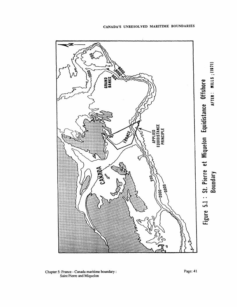
disagreement is the offshore continental shelf (Mills, 1971 ).
This chapter examines the origins and history of this boundary dispute with an
attempt made at possible boundary solutions. A comparison is made between this
boundary dispute and the Gulf of Maine dispute with an idea of the urgency of
resolving this dispute given. Initially though, an outline of the coastal configuration,
economic activity and offshore region under consideration is presented.
5.1 COASTAL CONFIGURATION AND LAYOUT
The islands of Saint Pierre and Miquelon lie, at their closest point, 14 nautical miles
south of Newfoundland, but the Canadian island known as Little Green Island lies
only three miles from the French coastline (Beauchamp et al., 1973). Within this area
Canada shares a territorial sea boundary with France as well as some form of dividing
Chapter 5: France - Canada maritime boundary : Page: 39 Saint Pierre and Miquelon

CANADA'S UNRESOLVED MARITIME BOUNDARIES
line delimiting the EEZ and continental shelf. This section gives a brief overview of the
land areas and the disputed offshore region.
Offshore, the dispute over the boundaries covers the western and south-western
portion of the Grand Banks, part of the southern continental slope and past the
midway point in the Laurentian Channel to the west (Figure 5.1). The Grand Banks
are of a unified composition and geological structure as they extend from
Newfoundland with the disputed portion dividing the Grand Banks from the Scotian
Shelf. The fishery of the region is rich with various migrating fish stocks entering the
region annually. Offshore energy resources have not been explored for within the
disputed area, but may be contained therein as finds have been announced for the
eastern Grand Banks and Sable Island regions.
The landmass of Saint Pierre and Miquelon is 93 square miles with a population of
6041 in 1982 (Canadian Hydrographic Service, 1983). The island of Saint Pierre
supports a harbour and town with the major industry tied to supplying the offshore
fishing fleets. A local fishing fleet also operates from the port of Saint Pierre with most
of the population concentrated within this port. Across the channel, Newfoundland
has a number of communities located at the tip of the Burin Peninsula that are similar
to the port of Saint Pierre. Each of these is also dependent on the fishery as the major
economic input to the region, with offshore energy exploration providing additional
economic input. For area, the island of Newfoundland is much greater at 42,734
square miles.
In determining the basepoint locations for a boundary delimitation, the straight
baselines and associated basepoints of Saint Pierre and Miquelon would be chosen for
France. Canada's straight baselines and the determining basepoints would be located
Page:40 Chapter 5: France - Canada maritime boundary : Saint Pierre and Miquelon
CANADA'S UNRESOLVED MARITIME BOUNDARIES
--,_ CD
In -cu ... ~ ... 0 E -= en -- a: = .....
t-
""" c&,) ""' u c:: ~ --~
""C ·-:::s cr
&..-&
c:: 0 -c&,)
:::s cr ·-::E -c&,)
c&,) ::-. .._ .._ .._ c&,) ~ ·- "C
a.. c:: = . - 0 en QQ
_. U"')
c&,) .._ = 't:U) ·-L.A..
Chapter 5: France - Canada maritime boundary : Page: 41 Saint Pierre and Miquelon

CANADA'S UNRESOLVED MARITIME BOUNDARIES
along the southern coast of Newfoundland, the Burin Peninsula, the Avalon
Peninsula, the eastern coast of Cape Breton, and Sable Island.
5.2 HISTORICAL BACKGROUND
In 1763 the islands of Saint Pierre and Miquelon were ceded to France as part of the
treaty ending the Seven Years war. This treaty also allowed for French fishing rights
along the coast of Newfoundland with the remainder of North America given to the
British. Since then, France has lost its rights to the Newfoundland coast but has kept
and developed the islands of Saint Pierre and Miquelon as French fishing outposts on
the Grand Banks. This section examines the recent history leading to the present
dispute between France and Canada over the offshore maritime boundaries.
Conflict initially arose over the maritime boundary in this area due to the promise of
offshore oil and gas in the early 1960s. On 17 October 1966, a Canadian order-in-
council designated certain shelf areas in the vicinity of Saint Pierre and Miquelon as
being open to exploration permits. On 24 December 1966, the federal government took
the rarely used step of advertising a public invitation to tender in the Canada Gazette on
these recently designated exploration blocks (Johnson and Zacher, 1977). These steps
were the first move toward applying jurisdiction over the region and were done to
establish de facto Canadian jurisdiction there (Johnson and Zacher, 1977).
The first French move to exert jurisdiction over the region also occurred in the area
of issuing oil and gas exploration permits. In 1967, the French government issued an
oil exploration permit to Petropar (now Elf Oil) in this region, an action that was even
more significant in view of the fact that the French Government itself held a large
equity interest in the company (Johnson and Zacher, 1977). A retaliation to this move
Page:42 Chapter 5: France - Canada maritime boundary : Saint Pierre and Miquelon
CANADA'S UNRESOLVED MARITIME BOUNDARIES
by France resulted in Canada issuing exploration permits to Mobile and Gulf in 1968.
These permits were issued such that there existed an overlap with the French permits
and thus a dispute arose. The area under dispute is shown in Figure 5.1 and is seen as
consisting of a large portion of the continental shelf south of Saint Pierre and Miquelon
and Newfoundland.
A move by France to exert jurisdiction over all its adjacent submerged lands
resulted in a 1968law proclaiming sovereignty over the continental shelf adjacent to
any French territory. This of course included the islands of Saint Pierre and Miquelon
and indicated a French right to the continental shelf in the region. In December 1968,
France passed this law regulating and proclaiming sovereign rights over the
exploration for, and exploitation of, natural resources of the continental shelf adjacent
to French territory, specifically including overseas French territories (Johnson and
Zacher, 1977). Subsequent to this, France and Canada agreed not to undertake any
provocative permit-granting activity in the disputed area, and oil companies were
advised to refrain from carrying out seismic and drilling operations until the conflicting
claims could be settled through bilateral negotiation (Johnson and Zacher, 1977).
Meetings have taken place since that time, but have not resulted in an open agreement,
with the areas in dispute still held as off-limits to exploration.
On 8 March 1970, Canada ratified the 1958 UN Continental Shelf Convention with
expressed reservations on France's declared reservations to the convention. As France
had earlier signed this agreement with reservations, Canada was reacting to a perceived
threat on the part of France regarding Canadian offshore claims. These of course were
directly related to the dispute over the area surrounding Saint Pierre and Miquelon. The
reservations may be stated as (Johnson and Zacher, 1977):
• The Canadian government indicated its dissatisfaction with a French reservation relating to a boundary calculated from baselines established after 29 April1958
Chapter 5: France - Canada maritime boundary : Page: 43 Saint Pierre and Miquelon

CANADA'S UNRESOLVED MARITIME BOUNDARIES
(the date the convention was signed) or to a boundary extending beyond the 200 metre isobath; and
• A Canadian reservation concerned the French reservation to a boundary in areas where there were "special circumstances" within the meaning of Article 6, para. 1 and 2.
These reservations were clearly directed at the boundary surrounding the islands of
Saint Pierre and Miquelon where the Canadian government felt that special
circumstances do indeed exist. In effect, the Canadian government was arguing that
such "special circumstances" warranted a substantial reduction in the shelf area
allocated to France (that is, the small area of the islands in relation to the shelf area
accruing under the equidistance principle) (Johnson and Zacher, 1977).
In 1971 France extended all of its territorial sea boundaries to 12 nautical miles.
This was in keeping with the changing definition on the legal extent of the territorial
sea. This extension of the territorial sea boundary to 12 nm around Saint Pierre and
Miquelon can be separated into two sections. First, an extension to 12 nm on the south
and west sides of the islands did not conflict with Canada's territorial sea extension.
However, on the east and north sides of Saint Pierre and Miquelon the 12 nm
territorial seas of both nations overlapped. These extensions to the territorial sea
required a dividing line within the separating channel.
On 27 March 1972, a Canada-France Agreement on Mutual Fishing Practices
addressed the landward boundary between Saint Pierre and Miquelon and
Newfoundland (Figure 5.2). From this 1972 agreement Symmons (1980) addressed
three factors :
• the agreement settled the maritime boundary on the landward side of the islands;
• Canada declared that if it were to extend its fishery limits in the future, it would subject to certain conditions, continue to recognize French fishing rights in the Atlantic; and
• the agreement contained a no prejudice clause which prima facie gave both states a carte blanche to declare future 200 mile fishery zones.
Page:44 Chapter 5: France- Canada maritime boundary: Saint Pierre and Miquelon

CANADA'S UNRESOLVED MARITIME BOUNDARIES
FRANCE SAINT PIERRE
CANADA A· .t·
BURIN PENINSULA
Figure 5.2 : 1972 Mutual Fisheries Agreement Boundary AFTER: SYMMON (1980)
Chapter 5: France - Canada maritime boundary : Page:45 Saint Pierre and Miquelon

CANADA'S UNRESOLVED MARITIME BOUNDARIES
The no prejudice clause was contained within Article 9 of the agreement and reads
(Symmons, 1980):
No provisions of the present agreement shall be interpreted as prejudicing the views and future claims of either party concerning internal waters, territorial waters or jurisdiction with respect to fisheries or the resources of the continental shelf.
This wording then tends to make the agreement hold only for the fisheries agreement
signed and not any binding boundary delimitation. The map indicating this boundary
(Figure 5.2) as established from the agreement shows an equidistant line being
followed that neglects Little Green Island situated in the channel. It is shown that Little
Green Island is not afforded a complete territorial sea of which it should be due. A
confusing aspect of this agreement is Article 8 which states (Symmons, 1980):
The line defined in the annex to the present agreement determines, in the area between Newfoundland and the islands of Saint Pierre and Miquelon, the limit of the territorial waters of Canada and of the zones submitted to the fishery jurisdiction of France.
As such, it would seem that the territorial sea boundary of Canada has been addressed
without addressing the same boundary of France. While at the same time, Article 8 is
delimiting a fisheries boundary for France without mention of a Canadian fisheries
boundary. This cumbersome wording makes it unclear whether it is a territorial sea
boundary or a 12 nm fisheries zone which is being delimited (Symmons, 1980).
The delimitation of the seaward boundary over the continental shelf was addressed
in May, 1972 with the Releve des Conclusions between Canada and France. This
confidential understanding between France and Canada, the exact details of which
have not been fully published, followed closely on the 1972 Mutual Fisheries
Agreement (Symmons, 1980). Although details are scarce on the 1972 Releve des
Conclusions, reference to the agreement is found in the continental shelf arbitration
case between Great Britain and France.
Page: 46 Chapter 5: France - Canada maritime boundary : Saint Pierre and Miquelon

CANADA'S UNRESOLVED MARITIME BOUNDARIES
By a French decree dated 25 February 1977, Saint Pierre and Miquelon became the
first French overseas insular possession to be granted a 200 mile EEZ. This French
decree may have been in response to Canada's Territorial Sea and Fishing Zones Act
of 1 January 1977 which established Canada's jurisdiction to 200 nautical miles.
Article 1 of the French decree stated that the interior limit of this zone was to extend
188 nautical miles from the territorial seas of the islands "sous reserve d'accords de
delimitation avec le Canada" (Symmons, 1980). Again this extension of its maritime
boundary around Saint Pierre and Miquelon to include a 200 nm EEZ was in keeping
with the trends of international law. Thus, France declared a full EEZ while holding
the practice of preserving a no prejudice clause within the decree thereby allowing for
further negotiations with Canada.
Finally, in September 1977, France defined the straight baselines from which the
islands adjacent territorial sea was to be measured with mention made of the 1972
France-Canada fisheries agreement (Symmons, 1980). To this point, both France and
Canada had declared the following :
• 12 nautical mile territorial seas;
• 200 nautical mile EEZs;
• jurisdiction over the adjacent continental shelf; and
• straight baselines for the purposes of delineating all these zones.
If ever there was a basis for disagreement, herein lay the cause. Active discussions and
negotiations have been ongoing between France and Canada toward finding a solution
to these areas of dispute. These negotiations resulted in a recent controversial
agreement between France and Canada that was arrived at only after a decade of
discussions.
Chapter 5: France - Canada maritime boundary : Page: 47 Saint Pierre and Miquelon

CANADA'S UNRESOLVED MARITIME BOUNDARIES
The agreement of January 1987 is a one year agreement signed between France and
Canada that provides for :
• fisheries harvesting within Canadian waters by France;
• licensing of the French factory freezer trawlers operating within the disputed zone by Canada;
• Canadian observer status on French vessels within Canadian waters; and
• provisions for further negotiations between France and Canada to find terms of reference for submittal of the boundary around Saint Pierre and Miquelon to third party arbitration.
Although the first three aspects of this agreement have proved controversial, it is
definitely in Canada's best interests to pursue an arbitrated solution to the offshore
boundary. Next, the possible solutions that may be found for this dispute are
presented.
5.3 BOUNDARY DELIMITATION SOLUTIONS
There does not seem to be an immediate identifiable simple solution to the offshore
boundary in the region of Saint Pierre and Miquelon, as was negotiated between
Denmark and Canada for the Arctic region. As a boundary solution, there does exist
the application of the equidistance principle in its true form, although how equitable a
solution this really is, is debatable. Treatment of Saint Pierre and Miquelon as enclaves
with only a 12 nm boundary is another solution, but again, is this equitable? This
section examines both of these possible boundary solutions as well as modifications to
these solutions with other boundary delimitations presented that have been arrived at
for similar island/mainland situations.
Page:48 Chapter 5: France- Canada maritime boundary: Saint Pierre and Miquelon

CANADA'S UNRESOLVED MARITIME BOUNDARIES
5.3.1 Pure Equidistance Principle
Under the 1958 Geneva Convention France claims offshore oil, gas and mineral rights
from Saint Pierre and Miquelon halfway (median-line) to the nearest parts of Canada
on three sides, and southward more than 200 nm to the outer edge of the continental
shelf (Beauchamp et al., 1973). This claim is based on the application of the
equidistance principle for delineating the maritime boundary and allots to France the
largest possible portion of the Grand Banks continental shelf to which it could be
entitled.
An equidistant boundary is presently shared by Canada and France on the landward
side of the islands. As shown in section 5.2, this boundary resulted from the 1972
Mutual Fisheries Agreement and is actually a modified equidistant line considering the
treatment given Little Green Island. Beginning with the endpoints of this dividing line,
France has proposed an equidistant line to delineate the southern Grand Banks. Such a
line is in the best interests of France while being detrimental to Canada. Geological
research shows that the continental shelf appurtenant to Saint Pierre and Miquelon
stretches a distance of about 400 kilometers south-west from the islands. Thus the
effect of the equidistance claim would be to encompass for France a seabed amounting
to 19,000 square miles and extending some 85 miles south of Saint Pierre, there being
170 miles between it and Nova Scotia (Symmons, 1980).
The fact that Saint Pierre and Miquelon are islands adjacent to Canada and thus
sharing the continental shelf should not in itself restrict France's fair claim to a portion
of the offshore zones. Arguably, a strict application of the equidistance principle as a
method of fair and equitable delimitation is justified. French history and jurisdiction in
the area have been established as long as Britain's and then Canada's. Also, an
equidistant line is recognized within international law as providing an equitable method
Chapter 5: France - Canada maritime boundary : Page:49 Saint Pierre and Miquelon
CANADA'S UNRESOLVED MARITIME BOUNDARIES
of boundary delineation under certain conditions. For France, the equidistant principle
would thus be applied to the territorial sea on the landward side and the EEZ and
continental shelf on the seaward side of the islands.
Canada has not accepted France's application of the equidistance line and has stated
that:
• the equidistant line is disproportionate when relating the land mass of Saint Pierre and Miquelon to Newfoundland; and
• special circumstances exist that deny the strict application of this argument.
It has been stated in the House of Commons (Symmons, 1980):
that it would be "unrealistic, in view of the land base involved, for Canada to permit a 200 mile zone on the seaward side" and that Canada made it clear in its talks with France that the land mass of Saint Pierre and Miquelon when compared with that of Newfoundland justified "a more appropriate solution than that suggested by the French government".
With the UNCLOS Ill agreement suggesting that an equitable solution be found, but
without giving specific methods, and looking at recent ICJ decisions, Canada's stance
on an alternative boundary delimitation being implemented is also justified.
The application of a pure equidistance line denies the south coast of Newfoundland,
west of the Burin Peninsula, any access to the Grand Banks. This would not be an
equitable delimitation for this region.
Any presentation by Canada may be backed up by the ICJ's decision in the North
Seas continental shelf case. In this case, the court stated that a delimitation according to
equitable principles should bring about a reasonable degree of proportionality
"between the extent of the continental shelf areas appertaining to a coastal state and the
length of the state's coast" (Karl, 1977). Canada's argument that Saint Pierre and
Miquelon are enclaves is now presented.
Page: 50 Chapter 5: France - Canada maritime boundary : Saint Pierre and Miquelon

CANADA'S UNRESOLVED MARITIME BOUNDARIES
5.3.2 Treatment as an Enclave
Since France and Canada do not themselves constitute adjacent or opposite states,
Saint Pierre and Miquelon could be considered as enclaves within Canadian territory.
As enclaves the two islands would maintain the same form of boundary on the
landward side while a boundary solution to the seaward side would substantially
reduce the French claim. As a minimum, France is guaranteed a 12 nm territorial sea
boundary to the south-west. In a delimitation according to equitable principles, a
reasonable degree of proportionality should exist between the effect given an island in
a delimitation and the island's coastline, measured in some objective fashion, relative
to the coastlines of the determining states (Karl, 1977). This proportionality may
extend French jurisdiction beyond 12 nautical miles but would in no way extend the
EEZ and continental shelf up to the limits originally delimited by France.
Canadian recognition of France's 12 nm territorial sea is contained within the 1977
Territorial Sea and Fishing Zones Agreement. This act specifies that Fishing Zone 4
does not include any areas within "the territorial sea of the islands of Saint Pierre and
Miquelon" (Symmons, 1980). Outside of the territorial sea of France, Canada has not
acknowledged any further jurisdiction on the part of France. Thus it would seem that
Canada's view is of France having a territorial sea, EEZ and continental shelf all
within a 12 nautical mile boundary.
The ICJ arbitration case on the delimitation of the continental shelf between Great
Britain and France (Figure 5.3) is noted as a precedent in this type of situation. While
looking at the boundary surrounding the British Channel Isles, the ICJ concluded that
(Colson, 1978):
The presence of these British Islands close to the French coast, if they are given full effect in delimiting the continental shelf, will manifestively result in a substantial diminution of the area of
Chapter 5: France - Canada maritime boundary : Saint Pierre and Miquelon
Page: 51

CANADA'S UNRESOLVED MARITIME BOUNDARIES
-Cl) r-Q)
c ""C' z:
c = en ~ .....
c 0.0 c.,
= a: ~ .....
1-..... 4
""C'
= a ~
~ ... .__ .. (..)
) = ~ ~
) u..
/ = ~ ~ :;: _.. ~
CQ
>-. a-~
""C = c::; :::s
: ~ 0 I CQ
/ I \ -J
~ ..c:
J en
/ '-"' n::l .·
/ _.. c:
~-· ~ c: _.. = 0
(..)
<""')
Lr)
~ a-
0 :::s 0.0 ·-"'-
Page: 52 Chapter 5: France- Canada maritime boundary: Saint Pierre and Miquelon

CANADA'S UNRESOLVED MARITIME BOUNDARIES
continental shelf which would otherwise accrue to the French Republic. This fact by itself appears to the court to be, prima facie, a circumstance creative of inequity and calling for a method of delimitation that in some measure redresses the inequity. ·
Although implementing a 12 nm boundary on the seaward side of the Channel Isles
that covered all the zones, the court did stress that there were factors both for and
against such a line and that it was the court's decision that this line was the most
equitable. This treatment by the ICJ of the Channel Isles was originally argued by
France with support for the enclave solution drawn from the 1972 Releve des
Conclusions agreement between France and Canada (Symmons, 1980). Thus it
appears that within this confidential agreement France and Canada have discussed
some form of enclave solution for the two islands off Newfoundland.
For an enclave method of delimitation to be adopted, various factors would have to
be addressed. These are :
• the historical rights established by France within the region;
• the socio-economic factors of population, fishing and farming established on Saint Pierre and Miquelon and Newfoundland;
• the guarantee of the UNCLOS III agreement to an EEZ and continental shelf for all coastal states; and
• the equity of the final boundary.
In determining the extent of the offshore zones beyond 12 nm both France and Canada
would have to agree that limiting special circumstances exist for both sides. Special
circumstances are introduced in the form of coastline, landmass and population ratios
as well as the distances of the two islands from France. Also, to the seaward side the
amount of territory involved allows a more generous solution than if the area was
cramped.
As a non-independent insular territory far removed from its metropolitan owner, the
French islands constitute a typical example of what has been dubbed the distant island
Chapter 5: France - Canada maritime boundary : Page: 53 Saint Pierre and Miquelon

CANADA'S UNRESOLVED MARITIME BOUNDARIES
problem (Karl, 1977). As distant islands of France, Saint Pierre and Miquelon disturb
the natural prolongation of Canada's jurisdiction over the offshore. By offering an
enclave solution, Canada is rectifying this problem and regaining jurisdiction over
what may be seen as Canada's offshore region.
Although Saint Pierre and Miquelon may be treated as enclaves within a boundary
solution, this does not ensure that the same boundary would be applied to all of the
zones. The treatment of the continental shelf boundary may be entirely different than
that given the EEZ boundary with any number of special agreements over each zone
contained in an agreement. These special agreements may also have an independent
boundary delimited for each one and could cover resource sharing within the fishery,
energy or mineral sectors. Overall, this type of solution may be the most equitable in
recognizing the special interests of both states over the offshore region. There is no
doubt that many islands may be viewed as "incidental special features" which, if given
full effect in continental shelf delimitations, would cause an unjustifiable difference of
treatment (Karl, 1977).
Should an enclave type of boundary be defined for the region and a special sharing
agreement occur for the offshore then France and Canada must look at what solution
would be the most equitable and best suited to national interests. Within this area there
are the living and non-living resources that would be shared. Presently, Canada has
been actively pursuing a sharing agreement for the fisheries of the Grand Banks with
France. This has been based on imposing quotas for the harvesting of fish caught by
each state thereby ensuring the future productivity of the region. Within the energy
sector no such agreement has been pursued. Yet, sharing agreements may be deemed
to be the most equitable for the energy resources lying within certain areas of the
disputed zone.
Page: 54 Chapter 5: France - Canada maritime boundary : Saint Pierre and Miquelon
CANADA'S UNRESOLVED MARITIME BOUNDARIES
Four solutions for the sharing of offshore energy resources have been proposed by
Lagoni (1979). These are:
• Geological cooperation in which each state receives a share of the total production in proportion to the amount of the reserve in its territory at the time the agreement was signed This type of agreement presently exists between Czechoslovakia and Austria but requires a prior delimitation of the boundaries.
• Joint cooperation between state operators in the region where they work closely together to exploit the resource through mutual agreements. The Federal Republic of Germany and the Netherlands presently employ this type of agreement.
• Unitized exploitation of common deposits where a single operator exploits the resource on behalf of the two states. An agreement of this form was entered into by Japan and South Korea and does not require as precise a definition of the state's boundaries.
• An agreement which has the states exercise joint control over the mineral resources of an area which is partitioned through mutual agreement by the states.
Again, a boundary solution would have to be arrived at beforehand.
The implementation of any of these agreements would seem to require that the states
establish their respective boundaries plus the zones of joint sharing. With such a large
discrepancy between the Canadian and French positions, a possible area of joint
concern may be established as was done with the fisheries agreement thereby
containing a no prejudice clause for future negotiation. Although not defining the exact
boundary which should be afforded the islands as enclaves, it has been shown that
treatment of Saint Pierre and Miquelon as enclaves is surely equitable.
5.3.3 Previous Island Agreements
Two previous island agreements where the islands of a distant state are located next to
the mainland of another nation are now presented. These agreements were arrived at
via different means; in one instance the boundary was arbitrated by the ICJ, whereas in
Chapter 5: France - Canada maritime boundary : Page: 55 Saint Pierre and Miquelon
CANADA'S UNRESOLVED MARITIME BOUNDARIES
the other the boundary was negotiated between the two states. It is shown that both of
these agreements may influence the final boundary delimitation around Saint Pierre and
Miquelon.
As stated in section 5.2, the continental shelf arbitration case between Great Britain
and France addressed the situation where the Channel Isles of Britain lay only a few
miles from the French coastline. During the hearings France argued that the Channel
Isles should be granted an enclave type of boundary based on the specific
geographical, geological and legal characteristics of the Channel Isles (Colson, 1978).
Since the rules of customary law applied in the area, the court took the view that the
question was whether the Channel Isles (Colson, 1978):
should be given the full benefit of the application of the principle of natural prolongation . . . or whether. their situation close to the mainland of France requires, on equitable grounds, some modification of the application of equidistance.
The court's decision was that the islands should be treated with a modification
resulting in an enclave boundary delimited to a distance not exceeding' 12 nautical
miles.
In reaching this decision the court took account of several factors that are similar to
the present Saint Pierre and Miquelon situation. First, as between France and the
United Kingdom, the Channel Isles had to be treated as islands of the United Kingdom
rather than semi-independent states (Colson, 1978). This treatment applies between
France and Canada where the islands of Saint Pierre and Miquelon are islands of
France having no type of independent status. Thus as the court of arbitration evaluated
the law and geography between Great Britain and France so too must the same be
evaluated between Canada and France, not Canada and Saint Pierre and Miquelon.
Second, the Channel Isles are of significant size and population and are of economic
and political importance (Colson, 1978). Again, the same may be said of Saint Pierre
Page: 56 Chapter 5: France- Canada maritime boundary: Saint Pierre and Miquelon

CANADA'S UNRESOLVED MARITIME BOUNDARIES
and Miquelon although the numbers differ with respect to population and economy for
those found in the Channel Isles. Third, the court considered the navigational, defense
and security interests of both parties within the area, recognizing the predominant
interest of France (Colson, 1978). Considering these same interests, one realizes the
predominance of Canada's defense and security interests in the Grand Banks region.
Finally, there is the fact that France cited the 1972 Releve des Conclusions as one
of its precedents with the court addressing this agreement. In examining the situation
of the Channel Isles with that of Saint Pierre and Miquelon, the court established that
there were distinguishing factors (Symmons, 1980):
The fact that in this region the mainland coasts of France and the United Kingdom are opposite each other distinguishes the case of the Channel Isles from such a case as that of St. [sic] Pierre and Miquelon, where there is no French coast opposite Newfoundland and where, in consequence, the continental shelf remains largely open both to the south and east. Also, that case is not one of opposite states, so that no question arises there of a delimitation between States, whose coastlines are in an approximately equal relation to the continental shelf to be delimited. There being nothing to the east of Saint Pierre and Miquelon except the open waters of the Atlantic Ocean, there is more scope for redressing inequities than in the narrow waters of the English Channel.
Next, the Papua New Guinea-Australia agreement in the Torres Strait is presented.
This agreement delimited the maritime boundaries of two Australian islands lying well
north of Australia but only miles off the Papua New Guinea coast. Although similar to
the Channel Isles case with respect to there being opposite coastal states involved, this
agreement was unique in that there were two boundary lines delimited.
The continental shelf dividing line was delimited with an equidistant line giving no
effect to the two islands, thus a median line exists as the dividing line in the Strait.
Also, the two islands were not afforded any continental shelf. But, in drawing the
dividing line for the EEZ and fisheries zones, the two islands were used as basepoints
for Australia. The maritime boundary agreement here has great significance as a
Chapter 5: France - Canada maritime boundary : Page: 57 Saint Pierre and Miquelon
CANADA'S UNRESOLVED MARITIME BOUNDARIES
precedent for the Franco-Canadian dispute since it shows that the same enclosing line
need not be adopted as an equitable solution for both the continental shelf and the 200
mile fishery zone/EEZ boundary (Symmons, 1980). This supports the adoption of two
different dividing lines off Saint Pierre and Miquelon that would address France's
historic fishing rights within the EEZ while allowing for Canada's natural prolongation
onto the continental shelf. Next, the urgency of resolving the dispute is examined.
5.4 SETTLEMENT URGENCY
It is now apparent from recent negotiations in St. John's, Newfoundland, and Paris,
France, that both countries would like to resolve the boundary dispute. Although, it
would appear that Canada wishes to conclude some form of agreement quickly
considering present federal government policy on the fisheries. With the fisheries
resource on the Grand Banks suffering from overfishing, there has been a depletion in
stocks, with French overfishing in the disputed zone contributing heavily to this
depletion. Thus, Canada is trying to manage the resource through quotas for each
nation including a quota for French fishing within the disputed area.
Canada would therefore like to find a negotiated agreement with France; but, with
present French fishing practices on the southern part of the Grand Banks below Saint
Pierre and Miquelon, France is not eager to give up any of the territory and offshore
rights that it considers French. This would also be true for French energy interests on
the Grand Banks, where prior French action in issuing offshore licences shows a
determined effort on the part of France to claim subsoil rights within the disputed
zone. Presently energy exploration and exploitation has been halted within the disputed
region until a resolution of the boundary dispute is solved. Coupled with present
Page: 58 Chapter 5: France- Canada maritime boundary: Saint Pierre and Miquelon

CANADA'S UNRESOLVED MARITIME BOUNDARIES
energy prices and the supply sided situation there is no impetus on behalf of renewed
energy exploration to quickly resolve the dispute.
Yet, some degree of urgency is attached when the view is taken that this dispute
could mushroom between friendly States. With Canada's firm stance on the fisheries
issue, the finding of an equitable boundary over the zones is all the more necessary.
The progress recently made to negotiate the terms of reference for submittal of this
dispute to a third party arbitrator indicates that this boundary is not negotiable, and that
both States find the World Court a better forum for delimiting the boundary in an
equitable manner.
5.5 GULF OF MAINE COMPARISON
In the Gulf of Maine, the dispute was submitted to arbitration before the ICJ; this type
of court implemented boundary solution is likely as Canada and France have recently
begun negotiations to submit the boundary to the world court. Should the dispute be
submitted to arbitration it is possible that a single boundary solution may be requested
for the continental shelf and EEZ as was done with the Gulf of Maine. However, this
type of solution may not be the most equitable.
The geographical idea of proportioning coastlines may be used, although this seems
unjust considering Saint Pierre and Miquelon's small size. With the geography of the
region dissimilar to that of the Gulf of Maine, there is not the same reasons for
proportioning the coastlines.
In examining the information and charts available it is seen that the offshore
boundaries and basepoints around Saint Pierre and Miquelon are easily delimited on
existing Canadian charts, Appendix B. Whereas both U.S. and Canadian charts were
Chapter 5: France - Canada maritime boundary : Page: 59 Saint Pierre and Miquelon
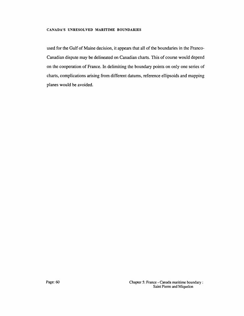
CANADA'S UNRESOLVED MARITIME BOUNDARIES
used for the Gulf of Maine decision, it appears that all of the boundaries in the Franco
Canadian dispute may be delineated on Canadian charts. This of course would depend
on the cooperation of France. In delimiting the boundary points on only one series of
charts, complications arising from different datums, reference ellipsoids and mapping
planes would be avoided.
Page: 60 Chapter 5: France- Canada maritime boundary: Saint Pierre and Miquelon

CANADA'S UNRESOLVED MARITIME BOUNDARIES
6.0 U.S. - Canada Maritime Boundary : Outer Georges Bank and Marchias Seal Island
Only the territorial sea dividing line around Marchias Seal Island and the outer
continental shelf dividing line beyond Georges Bank remain unresolved following the
1984 ICJ Georges Bank: decision. Within the Gulf of Maine region the 1984 ICJ
decision resulted in the final delimitation of the major portion of the U.S.-Canada
maritime boundary dividing this offshore region. The ICJ decision was initially
introduced in section 3.5 and is shown in Figure 3.5. Of concern in this chapter are the
two remaining sections of the boundary; that is, the inner territorial sea boundary from
Grand Manan Channel to Point A of the ICJ decision and again from the seaward end
point of the ICJ line, Point D (Figure 3.5), out over the remainder of the continental
margin.
The agreed starting point for the line established by the chamber was southward of
the international boundary terminus in Grand Manan Channel. This point was fixed by
the parties to avoid having the chamber rule on the status of Machias Seal Island.
Seaward of the line established by the ICJ, both Canada and the United States claim
jurisdiction in respect of the continental margin beyond 200 miles, in keeping with the
provisions of the 1982 LOS convention (Legault, 1984/5).
This chapter reviews the historical background of these two boundary sections after
initially showing the regional geography involved. After that, the possible solutions
for a dividing line are examined with both the pros and cons of each alternative
Chapter 6: U.S.- Canada maritime boundary: Outer Georges Bank and Marchias Seal Island
Page: 61

CANADA'S UNRESOLVED MARITIME BOUNDARIES
discussed. The urgency of resolving each section is explored with a final comparison
done with the ICJ Georges Bank decision. Also, in comparing the two boundaries
with the earlier ICJ line one must consider what kind of precedent this line will give to
the method of delimitation.
6.1 GULF OF MAINE LAYOUT
The Gulf of Maine coastal and offshore layout has been well defined by various
authors (Legault, 1984/5; Nichols, 1982) in their examination of the ICJ decision and
arbitration. For this reason, only the two areas of direct concern are presented. First~
the area surrounding Marchias Seal Island and its present territorial sea boundaries are
examined prior to moving offshore to look at the continental margin.
Marchias Sea Island is located west of Grand Man an Island within the entrance to
the Bay of Fundy. To the northeast and southwest of the island the maritime boundary
between Canada and the United States has been delimited. Between the boundary
terminus in Grand Manan Channel to the northeast, and Point A of the ICJ dividing
line to the southwest, there is a gap of about 45 miles in which the boundary between
the two countries has yet to be determined (Figure 6.1 ). It is easily seen that a
boundary agreement within this area depends heavily on the possession of Marchias
Seal Island. Lying west of Grand Manan Island a distance of 11.4 miles the island is
claimed by Canada; the U.S. also claims ownership of the island with a distance of
only 11.2 miles separating the state of Maine from the island.
Page:62 Chapter 6: U.S.- Canada maritime boundary: Outer Georges Bank and Marchias Seal Island
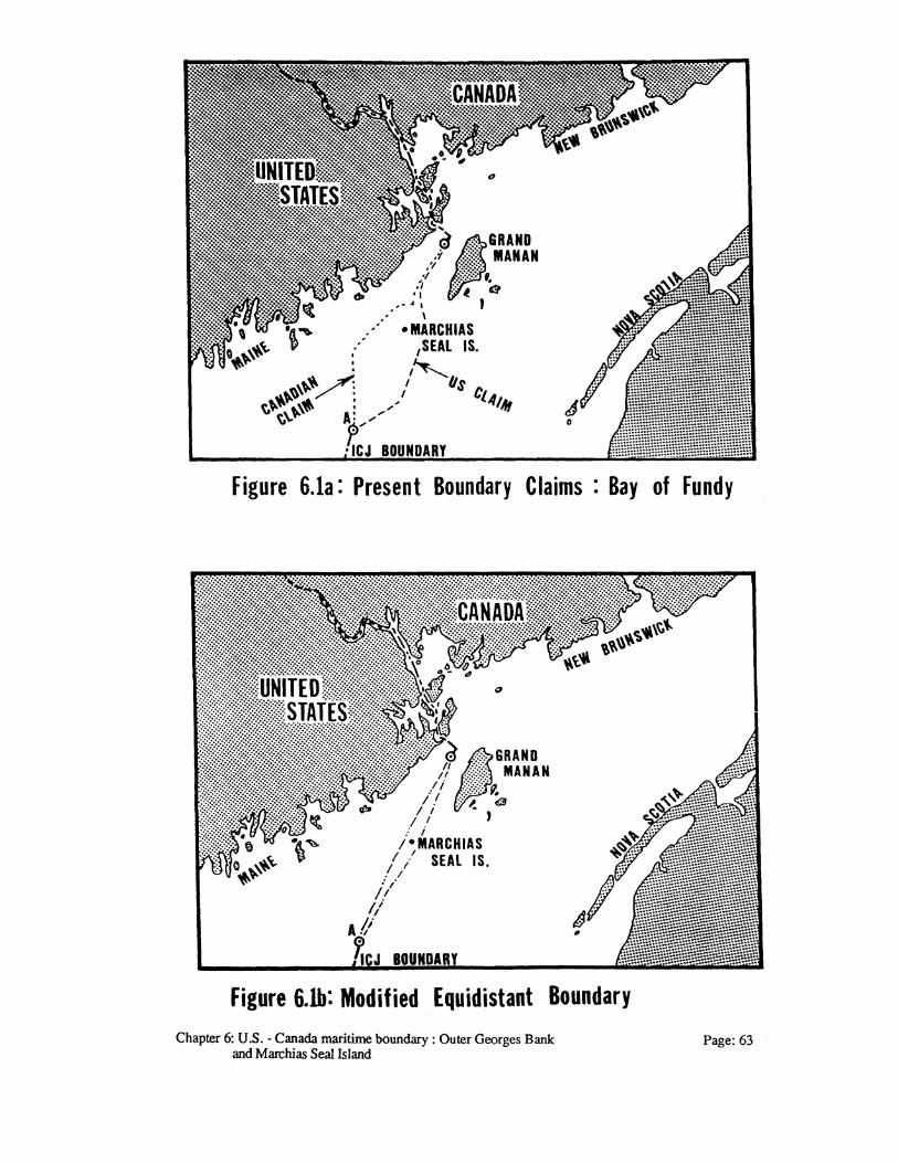
Figure 6.la: Present Boundary Claims : Bay of Fundy
Figure 6.lb: Modified Equidistant Boundary Chapter 6: U.S.- Canada maritime boundary: Outer Georges Bank
and Marchias Seal Island Page:63

CANADA'S UNRESOLVED MARITIME BOUNDARIES
Economically, the area around the island provides a rich seasonal fishery for the
local residents of New Brunswick and Maine. Although not considered a densely
populated area, the mainland region does support a diversified economy, with a main
emphasis on the local fishery. The island itself is only 15 acres (McEwen, 1986) and
is presently a proclaimed bird sanctuary under the Canadian Wildlife Service. Where
the unresolved dividing line begins in Grand Manan Channel between Grand Manan
Island and the state of Maine (Figure 6.1), the ownership of Marchias Island will
swing the dividing line either north or south.
The unresolved offshore boundary over the continental margin begins at Point D
(40° 27' 05"N, 65° 41' 59"W) which is the terminus point of the 1984 ICJ maritime
line. This point is south of Georges Bank and is located between the 3500 m and 4000
m isobath (Figure 6.2). This part of the continental shelf is beyond the fishing area and
would only offer economic activity in the form of offshore energy exploration. Yet,
even then the area is presently technically restrictive and economically unviable. Since
the UNCLOS III agreement provides for various methods of determining the outer
continental boundary, Appendix A, it is assumed that the United States and Canada
will opt for a boundary out to 350 nm This would be supported by all the definitions
of allowable boundary extension wherein the boundary must be no more than 350 nm
from the baselines from which the territorial sea is measured or a distance of 100 nm
from the 3500 m contour, Figure 6.2.
6.2 HISTORICAL BACKGROUND
Initially, the boundary case surrounding Marchias Seal Island is reviewed as no real
history is attached to the offshore continental margin area left unresolved by the recent
Page: 64 Chapter 6: U.S.- Canada maritime boundary: Outer Georges Bank and Marchias Seal Island

CANADA'S UNRESOLVED MARITIME BOUNDARIES
CANADA
figure 6.2: Outer Continental Shelf- Georges Bank Boundary
Chapter 6: U.S.- Canada maritime boundary: Outer Georges Bank and Marchias Seal Island
Page: 65

CANADA'S UNRESOLVED MARITIME BOUNDARIES
ICJ decision. As shown in Figure 6.1 Marchias Seal Island is about halfway between
the terminus of the early territorial sea boundary in Grand Manan Channel and Point A
of the EEZ and continental shelf arbitration line. As mentioned earlier, resolution of the
dividing line relies on the ownership of Marchias Seal Island being resolved.
Canada's claim to the island orginates with the Alexander Charter of 1621 whereby
a crown grant of Nova Scotia was given to Sir William Alexander (Nichols, 1982).
This original grant is made up of the present provinces of Nova Scotia and New
Brunswick and fixed part of the western limit of New Brunswick as a straight line
drawn across the mouth of the Bay of Fundy (McEwen, 1986). Due to the inadequate
mapping of the region at the time of the grant it is now difficult, and even impossible,
to establish the closing line across the Bay of Fundy.
The U.S. claim to Marchias Seal Island is based on the 1783 Treaty of Paris
wherein the United States was granted (Nichols,1982):
all islands within twenty leagues of any part of the shores of the United States ... excepting such islands as are now or heretofore have been, within the limits of the said province of Nova Scotia.
If 3 miles is accepted as equalling one league at the time of this treaty, then this
gives the United States ownership of all islands lying to a maximum distance of 60
miles from the coast of Maine. Marchias Seal Island is certainly within this area and
would thus belong to Maine, if it were not for the limiting factor that all islands lying
within six leagues, or 18 miles, of the Bay of Fundy closing line were to be
considered part of the original Alexander grant. Thus if Marchias Seal Island was part
of the original province of Nova Scotia, it would not be included in lands ceded to the
United States in 1783.
Page: 66 Chapter 6: U.S.- Canada maritime boundary: Outer Georges Bank and Marchias Seal Island

CANADA'S UNRESOLVED MARITIME BOUNDARIES
In 1814 the Treaty of Ghent was agreed to between the United States and Great
Britain. This engaged two commissioners to settle the title to the islands in
Passamaquoddy Bay and also the island of Grand Manan. As a result, Grand Manan
was declared to be part of Canada, but no mention of Marchias Seal Island was made
in the Commissioners' award of 1817 (McEwen, 1986).
Since 1784 New Brunswick has assumed administration of the island and
established a lighthouse there in 1832, with the Canadian federal government
maintaining the lighthouse since 1912 (Nichols, 1982). In 1944, the Canadian
government declared the entire island, together with a surrounding belt of water one
mile in width, to be a bird sanctuary (McEwen, 1986). It would appear that Canadian
possession has been open, notorious, and continuous since the eighteenth century with
American acts of possession consisting mainly of the drying of fish nets, storm
refuge, tourism and occasional smuggling (Nichols, 1982).
Prior to submitting part of the Gulf of Maine boundary to the ICJ, both states had
made full boundary claims within the Gulf of Maine and Bay of Fundy. These claims
outlined both states' position regarding Marchias Seal Island with the boundaries
shown in Figure 6.1a. The beginning point (A) for the ICJ arbitration (Figure 3.5)
was the point at which the original Canadian and American claims intersected within
the Gulf of Maine. From point A the American claim is seen as extending south of
Marchias Seal Island while the Canadian claim lies north of the island.
Offshore, from Point D (Figure 3.5) of the EEZ-continental shelf line out over the
open seas, the area left unresolved from the 1984 arbitration is relatively small. In this
area a further extension to the boundary line will result only after both nations have
decided on what they recognize as their continental margin and have published their
respective outer continental margin boundary limits. The history to this boundary
Chapter 6: U.S. -Canada maritime boundary : Outer Georges Bank and Marchias Seal Island
Page: 67

CANADA'S UNRESOLVED MARITIME BOUNDARIES
extension may be in that it was left unresolved by the 1984 ICJ arbitration, with both
Canada and the United States not stressing an early delimitation for the remaining
porti()n of the continental slope.
6.3 POSSIBLE BOUNDARY SOLUTIONS
With the majority of the boundary now resolved in the Gulf of Maine, priority has
switched from the Georges Bank to the area surrounding Marchias Seal Island as a
source of dispute between Canada and the United States. Although this dispute may
have been present all along, the recent ICJ decision has allowed this area to again
attract attention and stand out as an unresolved boundary. Since the ownership of
Marchias Seal Island will influence the delineation of the dividing line, the author feels
that four possible boundary delimitations exist, Figure 6.1a and 6.1 b.
From facts presented by McEwen (1986) and Nichols (1982) the case for Canada
seems reasonably strong based on historic title and unchallenged possession of the
island. With Canada's ownership of the island, a boundary line would lie north of
Marchias Seal Island and may be delimited either by the equidistance principle or some
modified form thereof.
The application of a pure equidistance dividing line with Marchias Seal Island as a
basepoint would be most advantageous for Canada. This median line would be centred
between the state of Maine and initially Grand Manan Island, extending westward to a
turning point a median distance from Maine and Marchias Seal Island, thence to Point
A of the ICJ maritime boundary (Figure 3.5). In so doing, this line would deny the
coast of Maine a portion of historic fishing grounds lying directly south of the state.
Perhaps a solution should take this into consideration.
Page: 68 Chapter 6: U.S.- Canada maritime boundary: Outer Georges Bank and Marchias Seal Island

CANADA'S UNRESOLVED MARITIME BOUNDARIES
One such solution would be to give Marchias Seal Island a half island effect thus
reducing its influence on the dividing line. Also, a dividing line such as the landward
dividing line between Saint Pierre and Miquelon and Newfoundland could be
implemented. In this way Marchias Seal Island would be treated much the same as
Green Island and allowed only a small territorial sea. However a modified median line
is found, it will have the effect of moving the dividing line south and perhaps being of
a more equitable form than the pure equidistance principle.
Should the United States be granted ownership ofMarchias Seal Island, then again
these two types of solutions exist. In the first instance, a pure equidistance line may be
implemented that would separate first Grand Manan from Maine, then Grand Manan
from Marchias Seal Island with the line terminating again at Point A. Although this
type of solution may be in the best interest of the United States, it would not be an
equitable boundary. If U.S. ownership was upheld, then the historic rights of Canada
within the Bay of Fundy could only be recognized through some form of modified
line. This time the line would be moved northward and westward in recognition of
Canada's interests.
Since this is both a territorial sea and EEZ boundary, then a delimitation between
Canada and the United States requires, that for the United States territorial sea, some
form of recognition must be given to a 12 nm territorial sea for the United States. This
may come about with the United States declaring a 12 nm limit or as a term of
reference submitted to a third party arbitrator. Thus any line delineated would
recognize a 12 nm limit and not the present 3 nm limit.
An extension south of Point D (Figure 3.5) to cover the area of the continental
margin left unresolved in 1984 should, for all purposes, follow the line segment C-D
(Figure 3.5). This type of solution would be in keeping with the chamber's decision
Chapter 6: U.S.- Canada maritime boundary: Outer Georges Bank and Marchi as Seal Island
Page: 69

CANADA'S UNRESOLVED MARITIME BOUNDARIES
and provide an equitable boundary line to both states. An alternative to following the
ICJ line would be the establishment of an equidistant line from Point D. The difference
between these two lines would result from coastline configuration and basepoint
location upon which the equidistant line is dependent. The final solution for this
segment of the Gulf of Maine boundary should be arrived at through negotiation rather
than arbitration. The same is not easily said for the inner dividing line where arbitration
appears to be the only route for fmding a maritime boundary.
6.4 SETTLEMENT URGENCY
Of the two unresolved boundaries, it has already been shown that the inner territorial
sea boundary surrounding Marchias Seal Island requires the more urgent resolution.
Yet, the dispute over ownership of Marchias Seal Island may delay a solution such that
a negotiated settlement of the outer continental shelf boundary may occur first.
The fisheries within the area of Marchias Seal Island is restricted to mainly an
inshore fishery with both Canadian and American fishermen of the local area
harvesting the resource. Thus the total economic contribution of the disputed area is
small when viewed within the overall scope of the Bay of Fundy and Georges Bank
fishery. What is important here is that either Canadian or American federal fisheries
officials may intervene and prosecute fisherman of the other nation thought to be in its
fisheries jurisdiction. Although this type of action may prompt a resolution to the
boundary, it does not seem justified in light of Article 9 as set out in the U.S.-Canada
Reciprocal Fisheries Agreement. This agreement states (Feldman and Colson, 1981):
Page: 70
In the boundary regions, the following principles shall be applied as interim measures of mutual restraint pending the resolution of
Chapter 6: U.S.- Canada maritime boundary: Outer Georges Bank and Marchias Seal Island

CANADA'S UNRESOLVED MARITIME BOUNDARIES
questions pertaining to the delimitation of areas subject to the respective fisheries jurisdiction of each party .
1. As between parties, enforcement shall be conducted by the flag state;
Although this agreement was entered into between Canada and the United States so
that conflicts within the disputed zone are avoided, there is no guarantee that both
states will continue to recognize the agreement. In this instance, any disregard for the
agreement will focus attention on the boundary dispute. Should a state wish to bring
the dispute to the forefront within the Marchias Seal Island disputed zone then this is
certainly an alternative.
A seaward extension to the ICJ line is not urgent. This boundary line may well be
one of the last lines delimited in resolving Canada's maritime boundaries. There are no
factors present within this region that could cause dispute requiring an urgent
settlement by either state.
6.5 GULF OF MAINE COMPARISON
The outer delimitation from the Georges Bank over the continental margin should
share the same technical aspects as the 1984 arbitrated boundary. Since this is only an
extension of the ICJ decision then the court's reasons for delimitation remain
unchanged. In this manner the Gulf of Maine arbitrated boundary remains as a
precedent for future boundary delineation. Having already resolved the 200 mile limit,
only a boundary extension over the continental shelf requires delimitation.
The dispute over the boundary within the area of Marchias Seal Island is seen as
being dissimilar to that of the ICJ resolved dispute. First, the ownership of Marchias
Seal Island must be resolved before any attempt can be made at deciding the maritime
Chapter 6: U.S.- Canada maritime boundary: Outer Georges Bank and Marchias Seal Island
Page:71

CANADA'S UNRESOLVED MARITIME BOUNDARIES
boundary. Once ownership is resolved, then the two states are dealing mainly with a
territorial sea boundary where the area of delimitation is restricted compared to the
Gulf of Maine.
The determination of the outer Georges Bank boundary should rely on the use of
geodetic lines and azimuths as did the 1984 ICJ decision. Also, the charts, Appendix
B, and specifications used by Beazley (1984) would help with the delineation.
Specifically, calculations would be done on a Universal Transverse Mercator (UTM)
grid centred at 68" West. Should the third line segment (C-D) be retained then the
boundary would adhere to its azimuth.
Page:72 Chapter 6: U.S.- Canada maritime boundary: Outer Georges Bank and Marchias Seal Island
CANADA'S UNRESOLVED MARITIME BOUNDARIES
7.0 U.S. - Canada Maritime Boundary : Juan de Fuca Strait
The offshore boundary extending from the terminus point of the present territorial sea
boundary in the Juan de Fuca Strait is not yet resolved. Yet, this boundary has
remained free of conflict and dispute since both states extended their offshore zones of
jurisdiction in the 1970s. This is due to the fact that both Canada and the United States
share a willingness to delimit the boundary using the principle of equidistance. It is
shown that this boundary delimitation should be arrived at via negotiation rather than
arbitration.
The region involved and historical background of the maritime boundary between
the province of British Columbia and the state of Washington are initially presented.
Next, a solution to the offshore boundary is given, followed by an examination of the
urgency attached to finding an equitable delimitation between the two states. Finally, a
comparison is attempted with the ICJ's boundary arbitration in the Gulf of Maine.
7.1 THE JUAN DE FUCA STRAIT REGION
The present boundary in the Juan de Fuca Strait terminates at boundary point number
12 located on a line joining Cape Flattery, Washington and Bonilla Pt., British
Columbia. As such, this line only delimits the territorial sea within the Juan de Fuca
Strait. Beyond the entrance to the Strait, there remains an unresolved boundary for the
Chapter 7: U.S.- Canada maritime boundary: Page:73 Juan de Fuca strait

CANADA'S UNRESOLVED MARITIME BOUNDARIES
remainder of the territorial sea plus the EEZ/fisheries zone and the continental shelf
between Canada and the United States.
The coastline involved in delimiting these boundaries consists of the western coast
of Vancouver Island and the northwestern coast of the United States. The basepoints
selected within Canada for an equidistant boundary construction should incorporate
those listed in the 1977 Territorial Sea and Fishing Zones Act. Outside of the points
located on Vancouver Island, Cape St. James on the southern tip of Moresby Island
would also be used for construction purposes. In the United States, either single
basepoints delimiting straight baselines would be selected or points along the low
water line chosen. These would be located within the states of Washington and
northern Oregon.
Although there is a tendency to follow the 49th parallel within this region, as it has
long been the land boundary, the proposed maritime boundary deviates from this
considerably. Using an equidistant construction technique, the offshore boundary is
influenced by the direction of Vancouver Island and the northern coast of Washington
State. Consequently, the boundary line follows a direction of approximately South 10•
West (Figure 7.1). For this to happen, Vancouver Island and the upper United States
is orientated south-east while the remainder of the United States follows almost a
southerly direction.
The offshore region supports an active fishery with Canadian and American
fishermen involved in both inshore and offshore fisheries. The continental shelf
restricts the outward extent of the fisheries zone as it is quite narrow at 50 miles to the
200 m isobath. This of course is in comparison to the Atlantic continental shelf. The
200 mile EEZ boundary is seen to extend beyond the edge of the continental shelf with
both countries fishing zones extending to 200 miles. Lying just outside the 200 mile
Page:74 Chapter 7: U.S.- Canada maritime boundary: Juan de Fuca strait

CANADA'S UNRESOLVED MARITIME BOUNDARIES
./
LAIM~.,.;~~~ _..,/~~'\
Figure 11 : Juan de Fuca Strait Offs.hore Region
Chapter 7: U.S. - Canada maritime boundary : Juan de Fuca strait Page:75

CANADA'S UNRESOLVED MARITIME BOUNDARIES
boundary is the Juan de Fuca Ridge. This is the major offshore anomaly over which
the continental shelf boundary must be extended. Closer to shore there is a channel
leading into Juan de Fuca Strait.
7.2 HISTORICAL BACKGROUND
This section examines the present maritime boundary within the Juan de Fuca Strait
with an outline given of the acts and agreements that both countries have passed or
entered into affecting the offshore zones.
Both the land boundary and maritime boundary separating Washington and British
Columbia were initially settled by the Treaty of Washington. This treaty settled the
land boundary as the 49th parallel and the water boundary within the Gulf of Georgia
by simply stating that the boundary line along the 49th parallel should run " ... to the
middle of the channel which separates the continent from Vancouver Island; thence
southerly through the middle of said channel, and of Fuca's Straits to the Pacific
Ocean" (Beauchamp et al., 1973). Besides this treaty, the United States and Britain
also entered into an agreement in 1873 that helped to further delimit the offshore
boundary in Juan de Fuca Strait. This agreement is known as the Northwest Water
Boundary Protocol and was entered into after disputes and skirmishes had arisen
within the region (Feldman and Colson, 1981).
Surveys of the boundary between British Columbia and Washington were
performed between 1909 and 1911 with monuments erected at that time along the
coast, Figure 7.2. This was done according to the provisions of Article 9 of a treaty
signed at Washington, D.C. in 1908 between Canada and the United States. The
boundary was established beginning at an initial point on the 49th parallel on the
Page:76 Chapter 7: U.S.- Canada maritime boundary: Juan de Fuca strait

CANADA'S UNRESOLVED MARITIME BOUNDARIES
I
r::: ~..,.I ~
0 ..... ..... I Cll::l ra ~-L. A... I QJ .....
~I E U)
~i ..... ra ~/ C".. L. (..) ,........: ra ~ I :::t: LoA-
~/ QJ
I L. ra <1> ~ "'C "'C ~I 'bl) ra ~i ~ r::: r:::
I ra ra c.,;) ~ - I
I >...
en L. ra
::::;::) "C
Chapter 7: U.S.- Canada maritime boundary: Juan de Fuca strait Page: 77

CANADA'S UNRESOLVED MARITIME BOUNDARIES
western side of Roberts Point and follows the middle Channel to the Pacific with
twelve turning points. This boundary is shown on the "Joint Chart of the International
Boundary Between United States and Canada From the Forty-Ninth Parallel to the
Pacific Ocean" (International Boundary Commission, 1921). As with the other
offshore regions, the boundary through Juan de Fuca Strait settled the question of
offshore jurisdiction until the two countries began extending their offshore zones with
the Truman Proclamation of 1945.
Beginning with Canada's Territorial Sea and Fishing Zones Act of 1977 and the
enactment of the United State's Fishery Conservation Zone of the same year, both
states announced economic jurisdiction off the coasts of Washington and British
Columbia to 200 kilometres. However, since the equidistance principle was employed
to delimit these zones by both countries a conflict over disputed territory was avoided.
7.3 A SOLUTION TO THE BOUNDARY DELIMITATION
With both countries adhering to an equidistance boundary for the seaward extension
from turning point 12 in the Juan de Fuca Strait, it would appear that this boundary
has been resolved. Yet, even though both states endorse a median line, the basepoints
from which this line is to be generated must be negotiated. Also, the line proposed by
Canada and that of the United States do not exactly agree, although negotiation should
find an equitable solution to this problem.
The United States has indicated its willingness to negotiate boundaries with Canada
based upon equidistance methodologies, with Canada adopting that approach for the
west coast boundaries (Feldman and Colson, 1981). For this reason, a negotiated
rather than arbitrated solution to this boundary should be found.
Page:78 Chapter 7: U.S. -Canada maritime boundary : Juan de Fuca strait
CANADA'S UNRESOLVED MARITIME BOUNDARIES
7.4 SETTLEMENT URGENCY
Of the four areas where Canada shares a maritime boundary with the United States, the
region off Juan de Fuca Strait offers the least resistance to settlement. As shown in
sections 7.2 and 7.3 both countries have proposed a boundary solution based on
adherence to a median line. This has resulted in similar boundary line proposals that
diminish the area of overlap and hence dispute. In attaching urgency to finding a
negotiated solution, previous boundaries have been shown to be in dispute due to
conflicts in either the energy or fisheries resource. This is not the case for the
boundary at the mouth of the Strait of Juan de Fuca as no current push for a settlement
is being proposed by the oil industry (Beauchamp et al., 1973). Also, the similarity in
boundaries of both countries has not provided for a dispute with the fishing industry.
Yet, a negotiated settlement may be pursued on account of possible mineral
resources. The Juan de Fuca Ridge just beyond the geological continental shelf, but
within the 200 nm zone on the west coast of the United States, is an area of interest for
polymetallic sulfides. The United States Department of the Interior is presently
exploring the possibility of issuing mineral leases in this area and it is all too likely that
polymetallic sulfides are adjacent to the Canadian west coast within 200 nautical miles
(McDorman, 1984 ). Should mineral resources be found within this area then they
would be located at the extremity of the zone of jurisdiction and where the largest
discrepancy in claims would lie.
Any urgency in resolving this boundary is thus dependent on initially finding
exploitable mineral resources within the region and their subsequent exploitation.
Politically, this boundary may be resolved rather quickly as it offers an expedient
solution through negotiation and would show that the present government is able to
realize a negotiated solution that is equitable for Canada.
Chapter 7: U.S. - Canada maritime boundary : Page: 79 Juan de Fuca strait

CANADA'S UNRESOLVED MARITIME BOUNDARIES
7.5 GULF OF MAINE COMPARISON
This section compares the future boundary delimitation between Washington and
British Columbia with the 1984 Gulf of Maine delineation. As shown previously, the
Gulf of Maine was resolved through arbitration, whereas the boundary off the Strait of
Juan de Fuca should be resolved by negotiation. Also, the amount of disputed territory
within the Gulf of Maine was such that it forced an arbitrated solution once both sides
conceded that negotiation was impossible. Off the Juan de Fuca Strait, it is not so
much the amount of disputed territory involved, but the finding of a single equidistant
line that remains to be resolved.
The use of a single boundary line to delimit both the continental shelf and fisheries
zones between Canada and the United States was enforced for the Gulf of Maine. This
type of single line solution should also be implemented in this instance, where both
states have proposed a median line out over the Juan de Fuca Ridge.
The complications arising from coastline and coastline ratios that occured in the
Gulf of Maine arbitration should not occur for the boundary off southern British
Columbia. The features of the Juan de Fuca Strait region are similar to those found in
the Beaufort Sea where a simplistic coastline is prevalent Unlike the limited number of
turning points required to delimit the Gulf of Maine boundary, Canada has proposed in
the Territorial Sea and Fishing Zones Act of 1977 an equidistant line requiring 45
turning points.
Finally, the delineation of the Juan de Fuca Strait offshore boundary will rely on
charts from both countries, Appendix B, to identify basepoints as was the case in the
Gulf of Maine. The area has been surveyed along both coasts with sufficient charts
available for the delimitation. These are at a large enough scale to identify all
basepoints while allowing for the delineation of the whole boundary on one chart. For
Page: 80 Chapter 7: U.S.- Canada maritime boundary: Juan de Fuca strait

CANADA'S UNRESOLVED MARITIME BOUNDARIES
Canadian purposes this would be chart number 3000 "Juan de Fuca Strait to Dixon
Entrance" at a scale of 1 : 1 250 000.
Chapter 7: U.S.- Canada maritime boundary: Page: 81 Juan de Fuca strait

CANADA'S UNRESOLVED MARITIME BOUNDARIES
Page:82 Chapter 7: U.S.- Canada maritime boundary: Juan de Fuca strait

CANADA'S UNRESOLVED MARITIME BOUNDARIES
8.0 U.S. - Canada Maritime Boundary : Dixon Entrance
The final maritime boundary examined is that lying within the Dixon Entrance region
and shared by the United States and Canada. This boundary is composed of a
boundary line that was arbitrated within the Dixon Entrance and the unresolved
boundary extending over the EEZ and continental shelf. The existing boundary, as
claimed by Canada within the Dixon Entrance, is disputed by the United States. It will
be shown that before the EEZ and continental shelf boundaries can be resolved, a
solution to the boundary within the Dixon Entrance will have to be found.
This chapter presents initially an outline of the coastal configuration and offshore
region. This is followed by a presentation of the history surrounding the boundary and
the possible boundary solutions available. Next, the urgency of resolving this dispute
is reviewed with a comparison attempted with the Gulf of Maine decision. As with the
previous chapters, the author has kept to a consistant chapter format. It is hoped that
the reader has not tired with this type of outline.
8.1 COASTAL CONFIGURATION AND OFFSHORE
LAYOUT
There exist two distinct coastlines that must be considered for the delimitation of a full
maritime boundary in the Dixon Entrance region. These coastlines are comprised of
Chapter 8: U.S.- Canada maritime boundary: Dixon Entrance Page:83

CANADA'S UNRESOLVED MARITIME BOUNDARIES
islands, an island archipelago and the mainland of Alaska and British Columbia. The
offshore region may also be divided into two areas that correspond to the two
coastlines, with one area within Dixon Entrance and another offshore Dixon Entrance.
For boundary construction purposes the mainland regions of Alaska and British
Columbia influence only the beginning portion of the territorial sea boundary near
Portland Channel. The remainder of Dixon Entrance is enclosed by the Queen
Charlotte Islands, the Alexander Archipelago and those islands close to but situated off
the mainland of both states, Figure 8.1. At the outside portion of Dixon Entrance a
distance of 33 miles separates the northern tip of the Queen Charlotte Islands from the
southern tip (Cape Muzon) of the Alexander Archipelago.
From a closing line drawn across Dixon Entrance, the determination of the offshore
EEZ and continental shelf boundaries rely on the configuration of the Queen Charlotte
Islands and the Alexander Archipelago. Overall the island coastline is orientated in an
east south-east direction. Thus a median line boundary will follow a west south-west
direction.
Offshore, the 200 metre isobath provides a natural division in the Dixon Entrance
with the 500 metre isobath being more representative of the continental shelf. The
exploitable continental shelf is restricted to about 10 miles west of the Queen Charlotte
Islands while providing a larger area off the Alexander Archipelago.
The region has a rich fisheries resource. Yet, the area is limited in population with
scattered communities along the coast of both states. The resources of the region are
not restricted to the fisheries as forestry and mining provide additional economic
stability.
Page:84 Chapter 8: U.S.- Canada maritime boundary: Dixon Entrance

CANADA'S UNRESOLVED MARITIME BOUNDARIES
1977 fiSHERY
Figure 8.I: Dixon Entrance Offshore Region Chapter 8: U.S. - Canada maritime boundary :Dixon Entrance
Page: 85
CANADA'S UNRESOLVED MARITIME BOUNDARIES
8.2 HISTORICAL BACKGROUND
Initially, the boundary in this region was shared between Great Britain and Russia
with a historical background equalling that of the Beaufort Sea maritime boundary. It
was shown in section 3.2 how the various tribunals in establishing the Alaska -
Canada land boundary laid the foundation for each state's present boundary claim in
the Beaufort Sea. The decisions of these tribunals are shown to be even more
significant for the maritime boundary within the Dixon Entrance.
The United States acquired Alaska from the Soviet Union in 1867 when Russia
ceded all of its North American possessions to the United States. This Treaty of
Cession described the boundaries of eastern Alaska by relying on the definition
provided within the 1825 treaty between Great Britain and Russia. Thus, the boundary
separating western Canada from Alaska in the Dixon Entrance region was initially
contained within Article III of the Anglo-Russian treaty. This is described as (Bourne
and McRae, 1976):
... Commencing from the southernmost point of the island called Prince of Wales, which point lies in the parallel of 54 degrees 40 minutes, north latitude, and between the 131st and 133rd degree of west longitude (Meridian of Greenwich), the said line shall ascend to the north along the channel called Portland Channel, as far as the point of commencement where it strikes the 56th degree of north latitude.
This is part of the same quotation used to initially define the boundary to the
Beaufort Sea in section 3.2. This delimitation of the boundary was found insufficient
with questions arising between first Great Britain and the United States and then
Canada and the United States over the boundary in Dixon Entrance. On 20 October
1903, a decision was handed down by the Alaska boundary tribunal that resulted from
a treaty dated 24 January 1903 between Great Britain/Canada and the United States.
This treaty requested that a series of questions on the wording of the Anglo-Russian
Page: 86 Chapter 8: U.S.- Canada maritime boundary: Dixon Entrance

CANADA'S UNRESOLVED MARITIME BOUNDARIES
Alaska boundary treaty be resolved. Questions over the wording arose due to the
discovery of gold in northern British Columbia with clarification of the boundary
between the two countries requested. This was in response to 30 years of diplomatic
dispute over the boundary, the establishment of boundary commissions and the
conduct of surveys, until eventually a convention was signed to answer this series of
questions (Bourne and McRae, 1976).
These questions were :
• what is intended as the point of commencement of the line ?;
• what channel is the Portland Channel ?; and
• what course should the line take from the point of commencement to the entrance to Portland Channel ?
The answers to these questions determine the boundary for part of the territorial sea of
the United States and Canada in Portland Channel and out into Dixon Entrance. Both
sides have agreed with the tribunal's decision on what constituted Portland Channel
with the United States disagreeing on the beginning point and the line followed from
there. This line is shown in Figure 8.2 as line A-B with point A located at the southern
tip of Muzon Island. This line denies a portion of territorial sea to the south of Muzon
Island. Thus, the largest item of concern is this line (A-B) from Cape Muzon (A) to the
mouth of Tongass Passage (B) since a misunderstanding of what this line stands for
has resulted in an ongoing dispute between Canada and the United States.
The full boundary within Dixon Entrance and Portland Channel, as delineated by a
joint U.S.-Canada survey, is shown on sheets No. 1 and No.2 of the "International
Boundary Between United States and Canada From Cape Muzon to Mount St. Elias"
series. These survey plans resulted from Article VI of the convention of 1903. After
the delimitation of line A-B there still remained the question of whether this line was
Chapter 8: U.S.- Canada maritime boundary: Dixon Entrance Page:87

CANADA'S UNRESOLVED MARITIME BOUNDARIES
Page: 88
DIXON ENTRANCE
Figure 8.2 : U.S.- Canada Boundary m Dixon Entrance
Chapter 8: U.S.- Canada maritime boundary: Dixon Entrance

CANADA'S UNRESOLVED MARITIME BOUNDARIES
intended as a maritime boundary, or whether it served simply to divide the land
territories of the respective nations (Bourne and McRae, 1976).
Since the Alaska tribunal determined line A-B as a boundary line, Canada has
argued that this line is both a territorial sea and EEZ dividing line with all waters south
of the line considered under Canadian jurisdiction. A fact that would seem to support
this is that until 1931 at least, the International Boundary Commissioners concerned
with fixing the Alaska boundary did not treat the A-B line differently from the other
sections of the Alaska boundary. In particular, during the 1920s the American
commissioner kept trying to persuade his Canadian counterpart to agree to request their
governments to move the boundary line from Cape Muzon to the middle of Dixon
Entrance (Bourne and McRae, 1976). Although discussions of the boundary
commissioners are not government policy, it would seem that the United States
commissioner realized the problems inherent in lineA-Band its more suitable location
in mid-channel. The U.S. commissioner thought line A-B to be anomalous since it
indicated that there was no territorial sea located at Cape Muzon (Bourne and McRae,
1976). The Canadian position remained unchanged and at the end of the 1920s the
U.S. argument was switched with a contention that line A-B was not a boundary line
at all but merely one of allocation, with high seas to the north and south of it (Bourne
and McRae, 1976).
A negotiated settlement that would have replaced line A-B with a median line in
Dixon Entrance was almost reached in 1945. The Canadian cabinet actually approved a
proposal that would have divided Dixon Entrance between Canada and the United
States by a median line, but would have allowed each state the right to fish and to
navigate on both sides of the line outside of the three-mile territorial sea (Bourne and
McRae, 1976). The proposal was approved by the United States but not accepted by
Chapter 8: U.S.- Canada maritime boundary: Dixon Entrance Page: 89

CANADA'S UNRESOLVED MARITIME BOUNDARIES
Canada because the government of British Columbia rejected it (Bourne and McRae,
1976). Recognition of the concerns of British Columbia by the Canadian federal
government may have set a precedent for future negotiations on offshore boundaries
where the provincial government concerned is also allowed input into the final
boundary delimitation. A case in point is the present Franco-Canadian boundary
dispute and what if any would be the Newfoundland provincial government's input to
the negotiating process.
Over the last four decades, disputes have arisen between the United States and
Canada that warrant a settlement to the entire boundary line in the area. These disputes
are a direct result of both countries exerting their sovereignty within the disputed zone.
Since 1964 the Canadian claim has received some recognition from the international
community, specifically Russia and Japan. These two countries were warned in 1964
to keep their fishing activities outside of Dixon Entrance and Hecate Strait as these
were Canadian waters. Both states heeded the warning and since then their fishing
vessels, apart from two or three Japanese incursions, have not entered the waters
(Bourne and McRae, 1976).
Under amendments to the Territorial Sea and Fishing Zones Act of 1970 the
Canadian government created a specific fishing zone in 1971 that extended far beyond
the twelve mile territorial sea baselines. In Dixon Entrance a line was drawn from point
A at Cape Muzon to a point on the northern part of the Queen Charlotte Islands. This
had the effect of enclosing the area within Dixon Entrance. This zone can only be
established legally if the claim to Dixon Entrance is valid, for it goes up to the shore of
another state (Bourne and McRae, 1976). So, although Canada was establishing this
fishing zone, recognition of it was denied by the United States, especially in the area
of Cape Muzon and its three mile limit. In 1969 the American authorities in Alaska
Page:90 Chapter 8: U.S.- Canada maritime boundary: Dixon Entrance
CANADA'S UNRESOLVED MARITIME BOUNDARIES
warned a research ship working for the Canadian government to leave waters within
three miles of Cape Muzon, and in 1971 they seized a Canadian fishing vessel and its
gear (Bourne and McRae, 1976).
Since the UNCLOS Ill agreement and previous international agreements recognize
that all states are entitled to a territorial sea and EEZ that are equitably delimited with a
neighbouring coastal state, there is now support for the United States position.
Therefore, based on the inequity of line A-B the United States proposed in 1973 that
the dispute over the significance of this line be submitted to the ICJ for arbitration. In
1974 Canada rejected the proposal (Bourne and McRae, 1976). So, although there
were a number of incidents in the disputed area Canada still chose not to bring the
dispute before the International Court of Justice.
Further laws passed by both states that extend the boundaries of their respective
fisheries zones to 200 nm have brought this boundary dispute within sharp focus
(Feldman and Colson, 1981). Canada's Territorial Sea and Fishing Zones Act of 1977
uses Cape Muzon as the initial turning point for the construction of an equidistant
boundary west 200 nm over the continental shelf. The United States disputes both this
line and its point of origin, with the United States Fishery Conservation and
Management Act of the same year delimiting the 200 nm fisheries boundary beginning
at a median point in Dixon Entrance, south of Cape Muzon.
The same approach has been kept by the United States in delimiting the line
followed by its 1983 EEZ off Dixon Entrance. Both sides are holding to their
arguments on line A-B and thus a solution has not yet been reached to this dispute.
Next, possible solutions for the resolution of this boundary are presented.
Chapter 8: U.S.- Canada maritime boundary: Dixon Entrance Page: 91

CANADA'S UNRESOLVED MARITIME BOUNDARIES
8.3 BOUNDARY DELIMITATION SOLUTIONS
It has been shown that within the Dixon Entrance region the main cause for dispute is
the line A-B and what exactly this line delimits. Offshore, the differences of the lines
described by both Canada and the United States for their respective fisheries zones are
not large. Since both states employ the equidistance principle to delimit these lines the
discrepancies between them can be attributed to the point of origin of both lines. Thus
prior to resolving the EEZ and continental shelf boundary, a solution to the dispute
over line A-B must be found.
Whether line A-B is resolved through negotiation or arbitration, there would appear
three possible solutions. These are :
• line A-B is held as the line delimiting the extent of Canadian jurisdiction as proposed by Canada with Cape Muzon used as the beginning point for further seaward boundary delimitation;
• line A-B is held as the line delimiting the internal waters of the United States and is thus a baseline for the further delimitation of the territorial sea for the United States. In this case a median point would have to be found to extend the EEZ and continental shelf boundaries; and
• line A-B is disregarded and a median line boundary established as was proposed in 1945 to divide Dixon Entrance.
Of these three solutions, the first is perhaps the most inequitable considering present
international law and the definitions of UNCLOS III, Appendix A, that delimit the
offshore zones. For, it is hard to justify a line that denies a part of a state any territorial
sea especially when that line is beyond the territorial sea of the state concerned. Also,
point A is located on the territory of the United States. Thus, with no Canadian land
holdings on Dall Island there remains only the Alaska Tribunal's decision of 1903 to
continue with this delineation.
This line could be found to be absolute, although it may be possible to negotiate a
sharing agreement between the United States and Canada that would recognize the
Page:92 Chapter 8: U.S.- Canada maritime boundary: Dixon Entrance

CANADA'S UNRESOLVED MARITIME BOUNDARIES
sovereignty of the two states in the region while allowing for joint resource
exploitation. Outside of an ICJ decision that would designate the of meaning this line,
it would seem that further dispute over the line remains certain.
The implementation of solutions two or three requires that either Canada relinquish
its present stance and agree to a negotiated boundary or have the dispute submitted to
the ICJ for arbitration. A possible boundary delimitation from the ICJ may recognize
the waters of Dixon Entrance as too broad to be regarded automatically as territorial
with each state entitled to the normal territorial sea (Bourne and McRae, 1976). In this
case, there would be also an EEZ boundary requiring delimitation within Dixon
Entrance with this line extending seaward to 200 nautical miles.
An adjudication of this dispute by the ICJ would depend on such concerns as
security and defence of each nation and the socio-economic conditions in the region.
The possibility of either state acquiescing to the others claim would also have to be
resolved; events reported by Bourne and McRae (1976) seem to indicate that past U.S.
and Canadian actions speak loudly, thus negating an argument based on acquiescence.
Bourne and McRae (1976) do suggest that the United States may be estoppelled from
denying Canada's claim, although one of the requirements of estoppel seems to be
missing, that is, Canada has not acted to its detriment based on statements of the
United States.
The submittal of the dispute to arbitration before the ICJ need not require that both
the inner and outer zones boundaries be adjudicated, it is possible that the ICJ may rule
only on the Dixon Entrance dispute. This would allow for a negotiated settlement
between the two states on a boundary over the EEZ and continental shelf.
Once the inner portion of the boundary is established then the two countries could
be seen as using an equidistant line to divide the EEZ and continental shelf. As stated
Chapter 8: U.S.- Canada maritime boundary: Dixon Entrance Page:93
CANADA'S UNRESOLVED MARITIME BOUNDARIES
in section 7.3, both governments have endorsed the equidistant principle for the west
coasts offshore boundaries. In fact, equidistant lines are presently used to delimit the
fisheries zones off Dixon Entrance. Although these lines originate from different
locations they terminate at approximately the same position. Thus, the final position of
the outer line is dependent on the starting point in Dixon Entrance whether it be at Cape
Muzon or a median point.
The final line in Dixon Entrance will determine the commencement of the northern
boundary between the economic zones of Canada and the United States in the
Northwest Pacific. There are obviously much greater expanses of water at stake in the
boundary question than those in Dixon Entrance when a 200 nm limit is considered
(Bourne and McRae, 1976). Yet, both countries remain in dispute over the inner line
in Dixon Entrance with no resolution in sight. The urgency to resolving this boundary,
in its entirety, is now discussed.
8.4 SETTLEMENT URGENCY
The inner boundary in Dixon Entrance has been disputed since it was arbitrated by the
Alaska Boundary Tribunal in 1903. It has been shown in section 8.2 that a
misunderstanding in wording has lead to a number of conflicts between Canada and
the United States that may have turned into incidents of violence. Thus there is an
urgency in resolving this dispute before a violent conflict occurs that may cause harm
to either party.
The present Canadian claim within Dixon Entrance provides for Canadian fishing
within three miles of the United States coastline. Thus although the depth of the Dixon
Page: 94 Chapter 8: U.S. - Canada maritime boundary : Dixon Entrance
CANADA'S UNRESOLVED MARITIME BOUNDARIES
Entrance Channel should restrict Canadian fishing to the southern area of Dixon
Entrance this is not the case. In this way there is a need by the fishing community to
resolve this boundary both for effective management and a resolution of resource
ownership.
Offshore there has been a moratorium on energy exploration imposed by the
Canadian government since the middle of the 1970s. This negates any sense of
urgency on behalf of the energy industry within Canada, although once this
moratorium is lifted, there may be pressure applied to resolve the offshore continental
shelf boundary. Since the EEZ and continental shelf boundaries are both dependent on
the Dixon Entrance dispute being settled, then any pressure toward resolving these
bears directly on the present boundary dispute over line A-B. Bourne and McRae
( 1976) conclude that pressure for the settlement of this dispute is most likely to come
as a result of the friction and conflict over fishing and continental shelf rights.
8.5 GULF OF MAINE COMPARISON
The present boundary dispute within the Dixon Entrance region shares many
similarities with the Gulf of Maine adjudicated boundary. First, there appears that a
portion of the Dixon Entrance boundary will only be resolved through arbitration. As
with the Gulf of Maine, Canada and the United States would only submit a specific
portion of the boundary to third party arbitration. In this case it would be the boundary
within the Dixon Entrance and possible the meaning of line A-B. This differs from the
Gulf of Maine decision where an offshore boundary over the EEZ and continental
shelf was delimited; here one is examining an inshore boundary.
Chapter 8: U.S.- Canada maritime boundary: Dixon Entrance Page:95
CANADA'S UNRESOLVED MARITIME BOUNDARIES
The use of a single line to delimit both the EEZ and continental shelf should also be
employed for this area. As with the Gulf of Maine single boundary line, an equitable
delimitation off Dixon Entrance would require a single line since no special
circumstances exist to justify two boundary solutions.
The coastal configuration for the construction of offshore boundaries outside of
Dixon Entrance is rather simplistic, Figure 8.1, and thus different than the Gulf of
Maine. Within Dixon Entrance the coastline is similar to that of the Gulf of Maine but
at a reduced scale. The need for proportioning coastlines as was done by the ICJ in the
Gulf of Maine does not seem to be required in this area.
As with the Gulf of Maine, there are sufficient charts for both basepoint
identification and boundary construction. Although these charts are at a smaller scale,
Appendix B, than those available in the Gulf of Maine, the delineation of boundaries
on these charts is not restricted.
Page:96 Chapter 8: U.S.- Canada maritime boundary: Dixon Entrance
CANADA'S UNRESOLVED MARITIME BOUNDARIES
9.0 CONCLUSIONS
Rather than attempting to delimit each boundary as the author feels it should be
delineated within the conclusions, this section will attempt a general summary of
certain points brought out in the paper. Also, general conclusions will be drawn on
certain aspects of the boundary delimitation process. This will be done before giving
individual conclusions for each boundary presented.
The final delimitation of all of Canada's offshore boundaries lies well into the future
as Canada and the states concerned attempt to find a settlement through negotiation
rather than arbitration. The choice between negotiation and litigation cannot be made in
the abstract. Each case must be considered on its own terms. Litigation, however, is
generally an option that is considered only where, for a variety of reasons, an
acceptable negotiated settlement is barred and an early resolution of the dispute is
essential (Legault, 1984/5). This is now the case for at least one of Canada's
unresolved boundaries, with France and Canada considering the submission of Saint
Pierre and Miquelon's offshore boundary to the ICJ.
In examining each of Canada's offshore boundaries there appears to be a certain
criteria required before any sense of urgency is attached to finding a boundary
settlement. It appears that the solution to a boundary dispute may be delayed as long as
the area of dispute does not contain :
• a large area of territory such that the conflicting claims result in a large disputed wne;
Chapter 9: Conclusions Page:97

CANADA'S UNRESOLVED MARITIME BOUNDARIES
• resources sought by both states (i.e. fisheries, energy or minerals) that result in open and hostile confrontation;
• sharing agreements to cooperate in exploiting the resources; or
• boundary positions that are in close agreement although not exactly the same.
The comparisons made with the Gulf of Maine decision showed that many
similarities exist between the circumstances encountered within the Gulf of Maine and
those found for individual boundaries. Yet, it appears that for the remaining three
Canada - United States boundaries neither government is trying to establish a link with
the ICJ decision. This is in keeping with a statement by Johnson and Zacher (1977)
indicating a separation of the Gulf of Maine decision and the other outstanding
disputes.
Beaufort Sea
The recent announcement by the United States that it will begin issuing offshore
exploration permits east of the !41St meridian beginning in 1988 has forced this
particular Canada - United States boundary issue to the forefront. The United States
has clearly stated its position that an equidistant line and not the !41St meridian, as
claimed by Canada, is the proper boundary delimitation. The positions held by the two
countries may finally dictate that an arbitrated solution to this dispute be found. At the
very least this announcement requires that negotiations be held prior to 1988 over this
particular boundary.
The considerable area under dispute off the Yukon and Alaska coastlines together
with both countries firm stances on their respective offshore boundary claims seem to
indicate that this is a boundary requiring litigation. As with the Gulf of Maine dispute,
arbitration would be performed by the ICJ. Although in this instance, the terms of
reference may not indicate the use of a single boundary line to delimit both the EEZ
and continental shelf.
Page: 98 Chapter 9: Conclusions

CANADA'S UNRESOLVED MARITIME BOUNDARIES
In presenting this boundary to the ICJ for settlement, the court would have to rule
on the validity of the sector principle for delimiting maritime boundaries. Therefore,
this is seen as a precedent setting case should it go to adjudication.
Labrador Sea and Lincoln Sea
With the majority of the maritime boundary already delimited between Denmark and
Canada through negotiation, the remainder of this boundary will, in all likelihood, find
a negotiated settlement There are no disputes in the areas requiring further delimitation
and thus no urgency to further extend the ends of the boundary. Should both nations
decide to fmish the boundary delimitation then an equidistant line would be used.
Saint Pierre and Miquelon and Newfoundland
After the extension of offshore boundaries during the last few decades, Canada and
France were able to successfully negotiate sharing agreements for the fisheries within
the disputed zone while conducting talks on the offshore boundary delimitation. These
agreements have begun to undergo stress as Canada claims French overfishing within
the disputed zone and the two countries remain at odds to the proper delineation of the
offshore boundary. For this reason Canada has been placed in a position where it
wishes to submit the dispute to arbitration before the World Court. Both countries
have been shown to have telling arguments (Beauchamp, et al., 1973) should the
dispute go to arbitration and thus the court's decision on an equitable boundary will
be, at the least, a difficult one.
Overall, it is Canada that would have the most to gain by an ICJ decision on the
boundary as this would allow for controlled management of the fisheries. Concerning
the peoples of Saint Pierre and Miquelon, the boundary should be most equitable if
consideration is given to their historic fishing rights, whereas for the French
Chapter 9: Conclusions Page:99

CANADA'S UNRESOLVED MARITIME BOUNDARIES
continental fishing fleet, an equitable boundary solution could restrict their present
fishing area on the Grand Banks considerably.
A solution by the ICJ may find that two boundaries are required in order to
recognize the historic rights of France on the Grand Banks and thus an enlarged
French EEZ beyond the 12 nm limit may be deemed appropriate. But, the court may
also recognize the natural prolongation of the continental shelf as being Canadian.
However the boundary is delineated, the Grand Banks have already been recognized
by the court as being of a large enough area to redress any inequities. Finally, the
hesitation by France to either negotiate a settlement or submit this dispute to arbitration
may result from a decision in her favour concerning the offshore areas appertaining to
the Channel Isles, which have a geographical analogy to that of Saint Pierre and
Miquelon (Gault, 1985).
Outer Georges Bank and Marchias Seal Island
The establishment of a boundary between the United States and Canada over the
remainder of the continental margin off Georges Bank will only come with time. First,
both nations must register their coordinates and method of delineating the continental
shelf with the United Nations. After this, a period of negotiation will precede any
agreement on the final boundary. At this point, these negotiations should be completed
by the U.S.- Canada International Boundary Commission. With the ICJ decision in
place, this delimitation is simplified as the basepoints and construction method are
readily available. If ever the 1984 decision was used as a precedent, this is the region
to which it would be applied.
The boundary in the Bay of Fundy surrounding Marchias Seal Island is another
story. This boundary is complicated by the ownership question of Marchias Seal
Island itself and is hotly contested by both countries. This disputed area will in all
Page: 100 Chapter 9: Conclusions

CANADA'S UNRESOLVED MARITIME BOUNDARIES
likelihood require third party arbitration to resolve not only the boundary, but the land
ownership question. It has been shown that this is an area of 'special circumstances'
requiring a solution recognizing the rights of both nations within the region.
By not including this section of the Gulf of Maine boundary for arbitration to the
ICJ in 1979, both nations were making a statement. This could be taken in two ways.
First, this dispute may not be of such importance that the two states warrant its
submittal to third party arbitration. Or, there exists a definite dispute here, only the
arguments by each state are different and neither state wished to submit this dispute at
the same time as the earlier EEZ and continental shelf dispute.
Juan de Fuca Strait Region
The EEZ and continental shelf off Juan de Fuca Strait offer an area that should be
delimited through negotiation. With both countries agreeing to the equidistance
principle and the absence of special circumstances that would negate its use, this
region is ready for an agreement. Whether the two countries will delimit an offshore
boundary over the continental margin past 200 nm remains as a question. Should the
United States and Canada file their claims on the continental shelf before the United
Nations for this area, prior to pursuing an agreement, then an extension of the
boundary to cover all of the zones is possible. It must be recognized that the possible
presence of offshore mineral deposits on the Juan de Fuca Ridge may in the future act
as a catalyst toward negotiation.
Dixon Entrance Region
Although the entirety of this boundary from Portland Channel seaward is
unresolved, there is a definite division between the region within Dixon Entrance and
the offshore EEZ and continental shelf zones. It would appear that third party
arbitration is again required to delimit the boundary within the Dixon Entrance. It has
Chapter 9: Conclusions Page: 101

CANADA'S UNRESOLVED MARITIME BOUNDARIES
been shown that opposing views are held by Canada and the United States on the
meaning of the 1903 Alaska Boundary Tribunal wording, specifically the meaning of
line A-B. In submitting this dispute to the ICJ it is recognized that only the inner
portion under dispute requires arbitration and a delimitation of the outer zones would
be pursued following settlement on the line A-B question.
As with each of the other boundaries, particularly the disputed boundaries, specific
concerns and facts exist to differentiate each unresolved boundary. In finding equitable
delimitations the states must address each boundary on an individual basis; this has
been shown to be the case. Finally, Canada has both time and space on its hands in
resolving each boundary and thus should never rush into an agreement, although to
avoid any hostile conflict, agreements over the most disputed zones should be pursued
actively.
Page: 102 Chapter 9: Conclusions

CANADA'S UNRESOLVED MARITIME BOUNDARIES
REFERENCES
Beauchamp, K., M. Crommelin and A.R. Thompson (1973). Jurisdictional Problems in Canada's Offshore. Alberta Law Review, Vol. 11.
Beazley, Commander Peter Bryan (1984). Delimitation of the Maritime Boundary in the Gulf of Maine Area. International Court of Justice Technical Report.
Bourne, C.B. and D.M. McRae (1976). Maritime Jurisdiction in the Dixon Entrance: The Alaska Boundary Re-Examined. The Canadian Yearbook of International Law, Vol. 14.
Canada Gazette (1977). Territorial Sea and Fishing Zones Act. Queen's Printer for Canada, Ottawa, January 1, 1977.
Canada Treaty Series (1974). Boundary Waters; Agreement Between Canada and the Kingdom of Denmark. Department of External Affairs, No 9.
Canadian Hydrographic Service (1983). Sailing Directions Newfoundland, 7th ed. Department of Fisheries and Oceans.
Canadian Hydrographic Service (1986a). Atlantic Coast Catalogue ofNautical Charts and Publications. Department of Fisheries and Oceans.
Canadian Hydrographic Service (1986b). Pacific Coast Catalogue of Nautical Charts and Publications. Department of Fisheries and Oceans.
Canadian Hydrographic Service (1986c). Arctic Catalogue of Nautical Charts and Publications. Department of Fisheries and Oceans.
COGLA (1985). The Canada Oil and Gas Lands Administration Annual Report 1985. Minister of Supply and Services Canada.
Colson, David A. (1978). The United Kingdom-France Continental Shelf Arbitration. The American Journal of International Law, Vol 72.
Feldman, Mark B. and David Colson (1981). The Maritime Boundaries of the United States. The American Journal of International Law, Vol 75.
Gault, Ian Townsend ( 1985). Jurisdiction over Petroleum Resources of the Canadian Continental Shelf: The Emerging Picture. Alberta Law Review, Vol. 23, No. 1.
References Page: 103

CANADA'S UNRESOLVED MARITIME BOUNDARIES
Hodgson, Robert D. and Robert W. Smith (1979). Boundary Issues Created by Extended National Marine Jurisdiction. Geographical Review, Vol. 69.
International Boundary Commission (1921). Joint Report Upon the Survey and Demarcation of the Boundary Between the United States and Canada From the Western Terminus of the Land Boundary Along the Forty-Ninth Parallel on the West Side of Point Roberts, Through Georgia, Haro, and Juan de Fuca Straits to the Pacific Ocean. Government Printing Office, Washington.
Johnson, Barbara and Mark W. Zacher (1977). Canadian Foreign Policy and the Law of the Sea. University of British Colombia Press.
Kapoor, D.C. (1976). The Delimitation of Exclusive Economic Zones. Maritime Policy and Management, Vol. 4.
Karl, Donald E. (1977). Islands and the Delimitation of the Continental Shelf: A Framework for Analysis. American Journal of International Law, Vol. 71.
Lagoni, Rainer (1979). Oil and Gas Deposits Across National Frontiers. American Journal of International Law, Vol. 73.
Legault, L.H. (1984/5). A Line for All Uses: The Gulf of Maine Boundary Revisited. International Journal, Vol40.
Lenarcik, J.M. (1985). The Impact of the Georges Bank Decision. Department of Surveying Engineering, University of New Brunswick, Technical Report II.
McDorman, Ted L. ( 1983). The New Defmition of "Canada Lands" and the Determination of the Outer Limit of the Continental Shelf. Journal of Maritime Law and Commerce, Vol. 14, No. 2.
McDorman, Ted L. (1984). The 1982 Law of the Sea Convention: The First Year. Journal of Maritime Law and Commerce, Vol. 15, No. 2.
McDorman, Ted L., Kenneth P. Beauchamp and Douglas M. Johnston (1983). Maritime Boundary Delimitation. Lexington Books.
McEwen Alec C. (1986). The International Boundary Commission Canada- United States. The Canadian Surveyor. Vol40, No.3.
Mills, Hal (1971). Eastern Canada's Offshore Resources and Boundaries: A Study in Political Geography. Journal of Canadian Studies, Vol6, No 3.
Nichols, Sue (1982). The Gulf of Maine Boundary : Reviewing the Issues. Occasional Paper No. 12. Department of Surveying Engineering. University of New Brunswick.
Energy, Mines and Resources Canada (1985). Surveys and Mapping 1984-85. Energy, Mines and Resources Canada.
Page: 104 References
CANADA'S UNRESOLVED MARITIME BOUNDARIES
Symmons C.R. (1980). The Canadian 200-Mile Fishery Limit and the Delimitation of Maritime Zones around St. Pierre and Miquelon. Ottawa Law Review, Vol. 12.
Theutenberg, Bo Johnson (1984). The Evolution of the Law of the Sea. Tycooly International Publishing Company.
United Nations (1983). The Law of the Sea: Official Text of the United Nations Convention on the Law of the Sea with Annexes and Index, Final Act of the Third United Nations Conference on the Law of the Sea. United Nations Publication.
References Page: 105
CANADA'S UNRESOLVED MARITIME BOUNDARIES
Page: 106 References
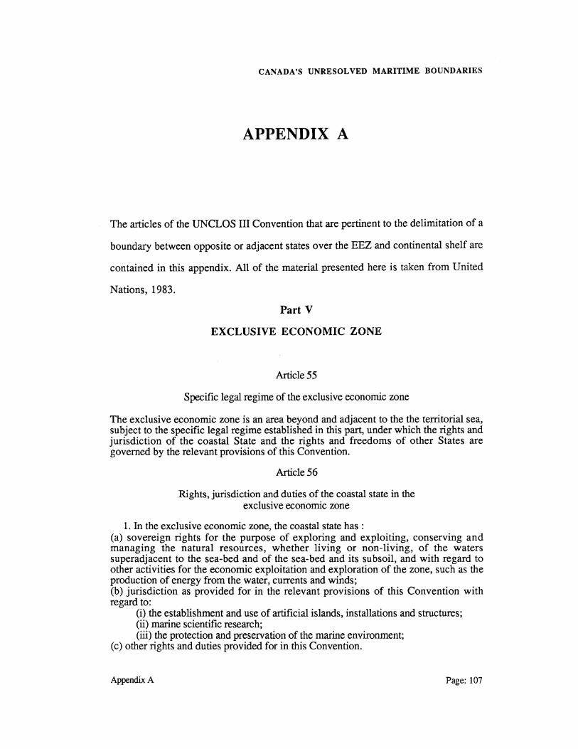
CANADA'S UNRESOLVED MARITIME BOUNDARIES
APPENDIX A
The articles of the UNCLOS III Convention that are pertinent to the delimitation of a
boundary between opposite or adjacent states over the EEZ and continental shelf are
contained in this appendix. All of the material presented here is taken from United
Nations, 1983.
Part V
EXCLUSIVE ECONOMIC ZONE
Article 55
Specific legal regime of the exclusive economic zone
The exclusive economic zone is an area beyond and adjacent to the the territorial sea, subject to the specific legal regime established in this part, under which the rights and jurisdiction of the coastal State and the rights and freedoms of other States are governed by the relevant provisions of this Convention.
Article 56
Rights, jurisdiction and duties of the coastal state in the exclusive economic zone
1. In the exclusive economic zone, the coastal state has : (a) sovereign rights for the purpose of exploring and exploiting, conserving and managing the natural resources, whether living or non-living, of the waters superadjacent to the sea-bed and of the sea-bed and its subsoil, and with regard to other activities for the economic exploitation and exploration of the zone, such as the production of energy from the water, currents and winds; (b) jurisdiction as provided for in the relevant provisions of this Convention with regard to:
(i) the establishment and use of artificial islands, installations and structures; (ii) marine scientific research; (iii) the protection and preservation of the marine environment;
(c) other rights and duties provided for in this Convention.
Appendix A Page: 107

CANADA'S UNRESOLVED MARITIME BOUNDARIES
2. In exercising its rights and performing its duties under this Convention in the exclusive economic zone, the coastal state shall have due regard to the rights and duties of other states and shall act in a manner compatible with the provisions of this Convention.
3. The rights set out in this article with respect to the sea-bed and subsoil shall be exercised in accordance with Part VI.
Article 74
Delimitation of the exclusive economic zone between States with opposite or adjacent coasts
1. The delimitation of the exclusive economic zone between States with opposite or adjacent coasts shall be effected by agreement on the basis of international law, as referred to in Article 38 of the Statute of International Court of Justice, in order to achieve an equitable solution.
2. If no agreement can be reached within a reasonable period of time, the States concerned shall resort to the procedures provided for in Part XV.
3. Pending agreement as provided for in paragraph 1, the States concerned, in a spirit of understanding and co-operation, shall make every effort to enter into provisional agreements of a practical nature and, during this transitional period, not to jeopardize or hamper the reaching of the final agreement. Such arrangements shall be without prejudice to the final delimitation.
4. Where there is an agreement in force between States concerned, questions relating to the delimitation of the exclusive economic zone shall be determined in accordance with the provisions of that agreement.
Article 75
Charts and lists of geographical co-ordinates
1. Subject to this part, the outer limit lines of the exclusive economic zone and the lines of delimitation drawn in accordance with article 74 shall be shown on charts of a scale or scales adequate for ascertaining their position. Where appropriate, lists of geographical co-ordinates of points, specifying the geodetic datum, may be substituted for such outer limit lines of delimitation.
2. The coastal State shall give due publicity to such charts or lists of geographical co-ordinates and shall deposit a copy of each such chart or list with the SecretaryGeneral of the United Nations.
Page: 108 Appendix A

CANADA'S UNRESOLVED MARITIME BOUNDARIES
PART VI
CONTINENTAL SHELF
Article 76
Definition of the continental shelf
1. The continental shelf of a coastal State comprises the sea-bed and subsoil of the submarine areas that extend beyond its territorial sea throughout the natural prolongation of its land territory to the outer edge of the continental margin, or to a distance of 200 nautical miles from the baselines from which the breadth of the territorial sea is measured where the outer edge of the continental margin does not extend up to that distance.
2. The continental shelf of a coastal State shall not extend beyond the limits provided for in paragraphs 4 to 6.
3. The continental margin comprises the submerged prolongation of the land mass of the coastal State, and consists of the sea-bed and subsoil of the shelf, the slope and the rise. It does not include the deep ocean floor with its oceanic ridges or the subsoil thereof.
4. (a) For the purposes of this convention, the coastal State shall establish the outer edge of the continental margin wherever the margin extends beyond 200 nautical miles from the baselines from which the breadth of the territorial sea is measured, by either:
(i) a line delimited in accordance with paragraph 7 by reference to the outermost fixed points at each of which the thickness of sedimentary rocks is at least 1 per cent of the shortest distance from such point to the foot of the continental slope; or
(ii) a line delineated in accordance with paragraph 7 by reference to fixed points not more than 60 nautical miles from the foot of the continental slope. (b) In the absence of evidence to the contrary, the foot of the continental slope shall be determined as the point of the maximum change in the gradient at its base.
5. The fixed points comprising the line of the outer limits of the continental shelf on the sea-bed, drawn in accordance with paragraph 4 (a)(i) and (ii), either shall not exceed 350 nautical miles from the baselines from which the breadth of the territorial sea is measured or shall not exceed 100 nautical miles from the 2500 metre isobath, which is a line connecting the depth of 2500 metres.
6. Notwithstanding the provisions of paragraph 5, on submarine ridges, the outer limit of the continental shelf shall not exceed 350 nautical from the baselines from which the breadth of the territorial sea is measured. This paragraph does not apply to submarine elevations that are natural components of the continental margin, such as its plateaux, rises, caps, banks and spurs.
7. The coastal State shall delineate the outer limits of its continental shelf, where that shelf extends beyond 200 nautical miles from the baselines from which the breadth of the territorial sea is measured, by straight lines not exceeding 60 nautical miles in length, connecting fixed points, defined by co-ordinates of latitude and longitude.
8. Information on the limits of the continental shelf beyond 200 nautical miles from the baselines from which the breadth of the territorial sea is measured shall be submitted by the coastal State to the Commission on the Limits of the Continental Shelf set up under Annex II on the basis of equitable geographical representation. The Commission shall make recommendations to coastal states on matters related to the establishment of the outer limits of their continental shelf. The limits of the shelf
Appendix A Page: 109

CANADA'S UNRESOLVED MARITIME BOUNDARIES
established by a coastal State on the basis of these recommendations shall be final and binding.
9. The coastal State shall deposit with the Secretary-General of the United Nations charts and relevant information, including geodetic data, permanently describing the outer limits of its continental shelf. The Secretary-General shall give due publicity thereto.
10. The provisions of this article are without prejudice to the question of delimitation of the continental shelf between States with opposite or adjacent coasts.
Article77
Rights of the coastal State over the continental shelf
1. The coastal, State exercises over the continental shelf sovereign rights for the purpose of exploring it and exploiting its natural resources.
2. The rights referred to in paragraph 1 are exclusive in the sense that if the coastal State does not explore the continental shelf or exploit its natural resources, no one may undertake these activities without the express consent of the coastal State.
3. The rights of the coastal State over the continental shelf do not depend on occupation, effective or notional, or on any express proclamation.
4. The natural resources referred to in this Part consist of the mineral and other nonliving resources of the sea-bed and subsoil together with living organisms belonging to sedentary species, that is to say, organisms which, at the harvestable stage, either are immobile or are under the sea-bed or are unable to move except in constant physical contact with the sea-bed or the subsoil.
Article 83
Delimitation of the continental shelf between States with opposite or adjacent coasts
1. The delimitation of the continental shelf between States with opposite or adjacent coasts shall be effected by agreement on the basis of international law, as referred to in Article 38 of the Statute of International Court of Justice, in order to achieve an equitable solution.
2. If no agreement can be reached within a reasonable period of time, the States concerned shall resort to the procedures provided for in Part XV.
3. Pending agreement as provided for in paragraph 1, the States concerned, in a spirit of understanding and co-operation, shall make every effort to enter into provisional agreements of a practical nature and, during this transitional period, not to jeopardize or hamper the reaching of the fmal agreement. Such arrangements shall be without prejudice to the fmal delimitation.
4. Where there is an agreement in force between States concerned, questions relating to the delimitation of the continental shelf shall be determined in accordance with the provisions of that agreement.
Page: 110 Appendix A

CANADA'S UNRESOLVED MARITIME BOUNDARIES
Article 84
Charts and lists of geographical co-ordinates
1. Subject to this part, the outer limit lines of the continental shelf and the lines of delimitation drawn in accordance with article 74 shall be shown on charts of a scale or scales adequate for ascertaining their position. Where appropriate, lists of geographical co-ordinates of points, specifying the geodetic datum, may be substituted for such outer limit lines of delimitation.
2. The coastal State shall give due publicity to such charts or lists of geographical co-ordinates and shall deposit a copy of each such chart or list with the SecretaryGeneral of the United Nations and, in the case of those showing the outer lines of the continental shelf, with the Secretary-General of the Authority
Appendix A Page: 111

CANADA'S UNRESOLVED MARITIME BOUNDARIES
Page: 112 Appendix A

CANADA'S UNRESOLVED MARITIME BOUNDARIES
APPENDIX B
This section details the charts relevant to each of Canada's maritime boundary areas
(CHS, 1986a); (CHS, 1986b); (CHS, 1986c). The charts are listed according to the
boundary area, the nationality of the chart, the chart number, chart title, and scale.
Table B.l Releyant Boundary Delimitation Charts Chart NO. CHART NAME
U.S.-Canada Boundary : Beaufort Sea (Canadian Charts) NIA International Boundary Along the 141stMeridian (Sheet 1) 7650 Barter Island to Toker Point (Navigation Chart) 7601 Siku Point to Kay Point (Navigation Chart) 7000 Arctic Archipelago ( Territorial Sea - 200 Mile Limit)
Greenland - Canada Boundary : Davis Straight (Canadian Charts) 430 Kane Basin to Lincoln Sea (Chart shows the dividing line
established between Canada and Greenland pursuant to the agreement between Canada and Denmark dated December 17, 1973.)
431 Cape Norton Shaw to Cape M'Clintock (Chart shows the dividing line established between Canada and Greenland pursuant to the agreement
, between Canada and Denmark dated December 17, 1973.) 432 Davis Straight and Baffin Bay (Chart shows the dividing line
established between Canada and Greenland pursuant to the agreement between Canada and Denmark dated December 17, 1973.)
5300 Ungava Bay (Navigation Chart) 7010 Davis Straight and Baffin Bay ( Territorial Sea - 200 Mile Limit) 7050 Resolution Island to Cape Mercy (Navigation Chart) 7052 Cape Mercy to Kangeeak Point (Navigation Chart) 7053 Padloping Island to Clyde Inlet (Navigation Chart) 7071 Cape Norton Shaw to Cape M'Clintock (Navigation Chart) 7072 Kane Basin to Lincoln Sea (Navigation Chart) 7217 Scott Inlet to Pond Inlet (Navigation Chart) 7220 Lancaster Sound, Eastern Approaches (Navigation Chart) 7302 Lady Ann Strait to Smith Sound (Navigation Chart) 7304 Lincoln Sea (Navigation Chart)
Appendix A
SCALE
62500 500 000 150 000
5 000000
500000
500000
2 000000
500000 2 000000
500 000 500 000 500 000 500 000 500000 350000 500 000 500000 500 000
Page: 113

CANADA'S UNRESOLVED MARITIME BOUNDARIES
Table B.l Releyant Boundary Delimitation Charts(con't) Chart NO, CHART NAME
Greenland-Canada Boundary : Davis Straight (Danish Charts) 1200 1300 1400 1500 1600 1700 3100 3200
SCALE
St. Pierre et Miquelon-Newfoundland Boundary : Atlantic Coast (Canadian Charts) 401 Nova Scotia (Territorial Sea and Fishing Zone Chart) 402 Island of Newfoundland (Territorial Sea and Fishing Zone Chart) 404 Gulf of Maine to Strait of Belle Isle (International Chart) 405 Saint Pierre et Miquelon (Chart shows the dividing line between
Canada and Saint Pierre and Miquelon pursuant to the agreement between Canada and France dated March 27, 1972)
415 Cape Ray to Saint Pierre (Territorial Sea and Fishing Zone Chart) 416 Saint-Pierre to St John's (Territorial Sea and Fishing Zone Chart) 405 Saint-Pierre and Miquelon (March 27, 1972 Fishing Boundary) 4000 Gulf of Maine to Baffin Bay (General Chart) 4015 Sydney to Saint Pierre (Loran C Coastal and General Chart) 4625 Burin Peninsula to St. Pierre ( Loran C Coastal Chart) 4626 Saint Pierre and Micquelon (France) ; (D2 Coastal Chart)
U.S.-Canada Boundary : Gulf of Maine Boundary (Canadian Charts) 4010 Bay of Fundy (Inner Portion) ; (Loran C Coastal and General Chart) 4324 Y annouth to Petit Passage (Small Craft Chart) 4326 Pubnico to Y annouth (Small Craft Chart) 4216 Cape Sable to Pubnico (Small Craft Chart) 4330 Baccara Point to Pubnico Harbour (Small Craft Chart) 8005 Georges Bank (Loran C Fisheries Chart)*
(U.S. Charts) 13241 Nantucket Island 13248 Chatham Harbour and Pleasant Bay 13246 Cape Cod Bay 13279 Ipswich Bay to Glouchester Hbr. 13290 Casco Bay 13325 Quoddy Narrows to Petit Manan I.**
Page: 114
1000000 720 200
3 500000 125 000
350 000 350 000 125 000
4 500 000 350 000 75000 75 000
200 000 63400 63400 37 500 63500
300 000
1:40000 1:20 000 1:80000 1:20 000 1:40000 1: 80 000
AppendixB

CANADA'S UNRESOLVED MARITIME BOUNDARIES
Table B.J Releyant Boundary Delimitation Charts Ccon't) Chart NO. CHART NAME
U.S.-Canada Boundary : Juan de Fuca Strait (Canadian Charts) NIA Joint Chart of the International Boundary Between United
States and Canada From the Forty-Ninth Parallel to the Pacific Ocean (Aprilll, 1908 Treaty Boundary)
391 Vancouver Island (Territorial Sea and Fishing Zone Chart) 3000 Juan de Fuca Strait to Dixon Entrance (Loran C General Chart) 3001 Vancouver Island, Juan de Fuca Strait to Queen Charlotte
Sound (Loran C General Chart) 3602 Approaches to Juan de Fuca Strait (Loran C Navigation Chart)
U.S. Canada Boundary : Dixon Entrance (Canadian Charts) 392 Queen Charlotte Sound to Dixon Entrance (Territorial Sea
and Fishing Zone Chart) 399 Fishing Zone 3/Zone de peche no 3, Queen Charlotte Sound,
Hecate Strait and Dixon Entrance (Territorial Sea and Fishing Zone Chart)
3000 Juan de Fuca Strait to Dixon Entrance (Loran C General Chart) 3002 Queen Charlotte Sound to Dixon Entrance (Loran C General) 3802 Dixon Entrance (Loran C Navigation Chart) 3868 Port Louis to Langara Island (Navigation Chart)
SCALE
200000
525 000 1 250 000
525 000
150000
525 000
525 000
1250000 525 000 200000
72 900
* **
Beazley (1984) uses this chart to delimit the line crossing Georges Bank. This chart was not used in the ICJ court decision but would be used for the resolution of the territorial sea in Fundy Bay.
Appendix A Page: 115

CANADA'S UNRESOLVED MARITIME BOUNDARIES
Page: 116 AppendixB