canadian landscapes fact sheets moraines -...
TRANSCRIPT

Glaciers carry and deposit debris that they erode from what they flow over. At the edge of the ice, some of this debris is deposited in moraines; other types of moraines form under or on top of melting ice.
MorainesMorainesCanadian Landscapes Fact Sheets
http://landscapes.nrcan.gc.ca

What is a moraine?
A moraine is a mound, ridge, or other distinct accumulation of generally unsorted, unstratified glacial debris (called till), deposited by direct action of glacier ice . A moraine can take a variety of topographic forms that are independent of control by the surface on which it lies.
Moraine formation
Through the processes of plucking, abrasion, rocks falling from valley sides, and a bulldozing-like action, a glacier collects unconsolidated (loose) debris and includes it in the mass of ice. This sediment, made of rock particles of all different sizes, builds up at the front, sides, and base of the ice. The sediment is brought towards the ice margin and is deposited as the ice melts.
Moraine types
There are many types of moraines, which are identified on the basis of their shape, and on their location in relation to the glacier. This document will illustrate the following types of moraines: end moraine, ground moraine, hummocky moraine, kame moraine, lateral moraine, medial moraine, recessional moraine, terminal moraine, thrust moraine, De Geer moraine and Rogen moraine.
Bulldozing action
A glacier advances over the bare land ( ). When the ice begins to melt ( ), moraines and meltwater features are deposited onto, or carved into, the landscape ( ).
Bulldozed debrisat the ice front
Glacier
1 2 3
4
1 2 3 4
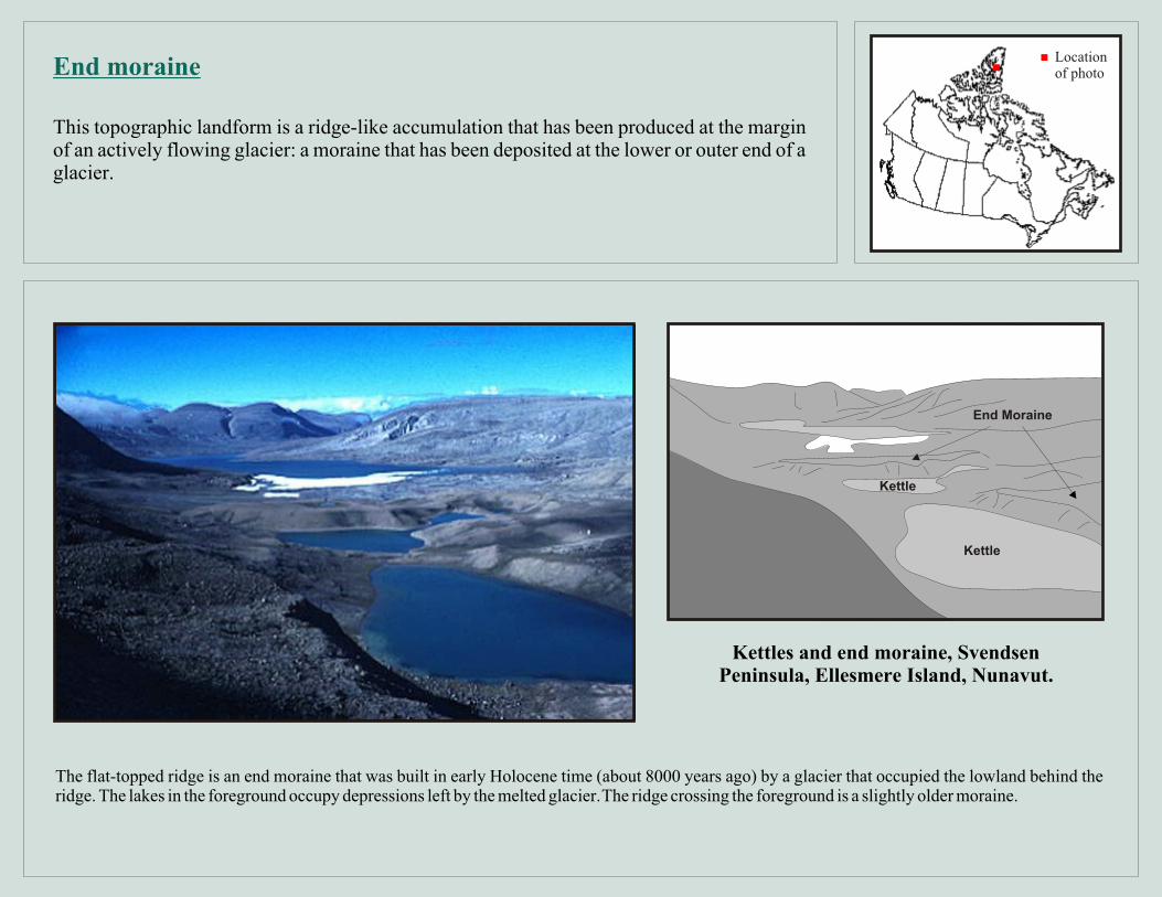
The flat-topped ridge is an end moraine that was built in early Holocene time (about 8000 years ago) by a glacier that occupied the lowland behind the ridge. The lakes in the foreground occupy depressions left by the melted glacier. The ridge crossing the foreground is a slightly older moraine.
Kettles and end moraine, Svendsen Peninsula, Ellesmere Island, Nunavut.
This topographic landform is a ridge-like accumulation that has been produced at the margin of an actively flowing glacier: a moraine that has been deposited at the lower or outer end of a glacier.
End moraine
End Moraine
Locationof photo
Kettle
Kettle
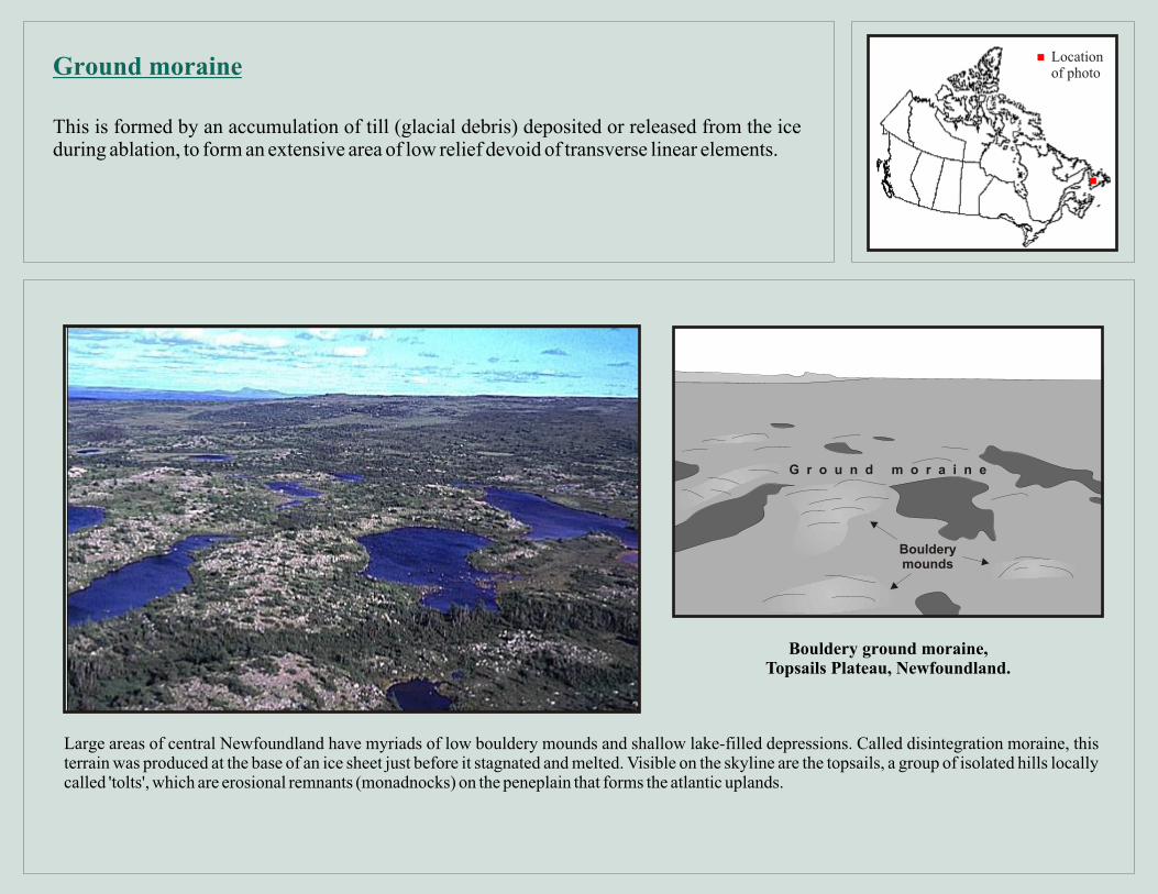
Large areas of central Newfoundland have myriads of low bouldery mounds and shallow lake-filled depressions. Called disintegration moraine, this terrain was produced at the base of an ice sheet just before it stagnated and melted. Visible on the skyline are the topsails, a group of isolated hills locally called 'tolts', which are erosional remnants (monadnocks) on the peneplain that forms the atlantic uplands.
Bouldery ground moraine, Topsails Plateau, Newfoundland.
This is formed by an accumulation of till (glacial debris) deposited or released from the ice during ablation, to form an extensive area of low relief devoid of transverse linear elements.
Ground moraineLocationof photo
Boulderymounds
G r o u n d m o r a i n e

This scene comprises an unbroken expanse of till hummocks, which extends from the foreground to the distant horizon. These hummocks are 8-10 m in width and up to 100 m in length.
A landscape of hummocky moraine south of the Cypress Hills, southwestern
Saskatchewan.
This term is used for an area of knob-and-kettle topography that may have been formed either along an active ice front or around masses of stagnant ice. Knob-and-kettle topography is an undulating landscape in which a disordered assemblage of knolls, mounds, or ridges of glacial drebris is interspersed with irregular depressions and pits (kettles) that are commonly undrained and may contain swamps or ponds.
Hummocky moraineLocationof photo
Hummocks
Kettle

This great mass of contorted, gravelly sand is a prominent feature on the eastern coast. Most of the material derives from the granitic rocks of the Precambrian Shield far to the north. This feature, a kame moraine, was deposited against glacier ice during the main stage of the last glaciation, when the Laurentide Ice Sheet filled the Gulf of St. lawrence. These sandy glacial deposits, and not the local sandstone bedrock, are the main source of the modern coastal beaches in that area.
Kame moraine, La Bluff, Îles de la Madeleine, Québec.
This is an end moraine that contains numerous hummocky mounds of irregularly bedded sand and gravel with subordinate till, deposited in patches from meltwater flowing in contact moving or decaying glacier.
Kame moraine
Kame moraine
Locationof photo

This glacier has constructed massive sharp-crested lateral moraines at the limit of its expansion during the "Little Ice Age" a few centuries ago. The more rounded end moraine at the front is draped over with fine narrow ridges. These are medial moraines which originated by the junction of tributary glaciers upstream.
Moraines of a valley glacier, Bylot Island, Nunavut.
This is a ridged moraine carried on, or deposited at or near, the side margin of a mountain glacier. It is composted chiefly of rock fragments loosened from the valley walls by glacial abrasion and plucking, or fallen onto the ice from the bordering slopes.
Lateral moraineLocationof photo
End moraine
Glacier
Lateralmoraines

This photograph shows the formation of a medial moraine. When two tributary glaciers, such as those in the photograph, meet around an unglaciated bedrock knob (nunatak), their lateral moraines merge, forming a line of sediment in the middle of confluent glaciers. The sediment of the medial moraine is composed of rock fragments that are eroded by the advancing ice or deposited onto the ice margin by rock falls from the valley walls. Many large valley glaciers exhibit multiple medial moraines, representing the merged tributaries that formed the valley glacier.
Medial moraine formation, St. Elias Mountains, Kluane National Park,
Yukon Territory.
This is an elongate moraine carried in or upon the middle of a glacier and parallel to its sides, usually formed by the merging of adjacent and inner lateral moraines below the junction of two coalescing valley glaciers.
Medial moraineLocationof photo
eniarom laide
M
Lateralmoraines
Glacier ice

This photograph illustrates a number of interesting features (foreground to background): a small neoglacial (recent) moraine, a proglacial lake, the modern end moraine, debris covered ice of the glacier terminus, bare ice of the ablation zone, the snow apron along the margins of the glacier, and the bedrock cliffs of a cirque amphitheatre. The moraines and the lake are created by the melting of the cirque glacier. In the ablation zone, debris melts out from ice and accumulates at the ice-margin, forming a recessional moraine. The meltwater feeds the lake. The absence of debris upglacier of the terminus, but within the ablation zone, reflects differences in the flow path of the ice to the terminus. The debris-free ice, may have a shallow flow path, thereby incorporating less debris,or have a lower rate of ablation, resulting in a diminished ability to concentrate the debris present in the ice. The snow apron represents the thickest part of the accumulation zone of the glacier and is accentuated by the avalanche of snow and rock debris from the cliffs.
Cirque glacier, Torngat Mountains, Labrador.
This term refers to an end or lateral moraine built during a temporary, but significant, pause in the final retreat of a glacier. It can also be a moraine built during a minor re-advance of the ice front during a period of general recession.
Recessional moraine
Neoglacial moraine
Endmoraine
Bedrock cliffs
eic reG ilac
d icer eeD ve ocb s ri
glacialPro lake
wo n S a p r o n
Locationof photo

The figure in the foreground of this photograph is standing on the terminal moraine of the glacier on the left. Terminal moraines mark the maximum limit of a glacier’s advance, and they form when the debris begins to accumulate at the ice margin. As the ice melts, the released debris coats the surface, as can be seen along the base of this glacier. It then slips or flows off the surface, further adding to the moraine. This moraine stands at least 10 m above the plain over which the glacier is advancing. In the higher parts of the glacier, horizontal lines of debris can be seen.
Terminal moraine, southern Bylot Island, west of Aktineq Glacier, Nunavut.
This designation has been given to the end moraine that marks the farthest advance or maximum extent of a glacier. It is the outer-most end moraine of a glacier or ice sheet and is formed at or near a more-or-less stationary ice margin, or at a place marking the cessation of an important glacial advance.
Terminal moraine
Glacier
Terminal moraine
Plain
Locationof photo
sdnab sirbeD

Glacio-tectonic thrust plates of outwash have been stacked in as rigid plates in front of glacier C79. The surfaces of the plates, which are greyish-brown, slope toward the ice, visible to the left.
Thrust moraine of Glacier C79,Bylot Island, Nunavut.
An ice-thrust moraine is a ridge, composed of bedrock, till, or other material that was either, pushed by glacier ice or dragged along the base. After ice retreat (melting), the material is left stacked in a series of ridges on the landscape.
Thrust or push moraineLocationof photo
Glacier
Thru es nt i m rao

Seen in lakes as narrow peninsulas, islands, and shoals spaced about 200 m apart, these narrow, parallel glacial ridges are called De Geer moraines, after the Swedish geologist who first deduced that the ridges mark the winter positions of glacier margins that retreated in contact with a water body. Here, about 10000 years ago, the glacier margin retreated southward (to the upper right) toward the Long Mountains. The moraines mark successive positions of the ice front as it retreated against a high level sea which stood 60 meters above present sea level.
De Geer moraines, near Ten Mile Lake, Newfoundland.
A moraine perpendicular to the direction of ice flow, forming a low, relatively narrow ridge of water-sorted till; De Geer moraines are deposited in shallow bodies of water at a glacier snout.
De Geer moraineLocationof photo
De Geer moraines

Long drumlinoid ridges (seen in distance) are overlaid with transverse ribs, here trending obliquely from the lower left. The ribs, called rogen moraine, are pushed up as the ice sheet thins, slows, and tends to plough the underlying drift rather than mould it. During stagnation and disintegration the ice sheet deposited till hummocks and mounds which here form islands and shoals.
Rogen moraine with hummocks, Cobrielle Lake, Kejimkujik National Park, Nova Scotia.
A moraine perpendicular to the direction of ice flow, formed of large-scale transverse ridges giving the overall appearance of an animal's ribs. The ridges, consiting of till for the most part, are generally steep-sided. In plan view, they appear slightly curved and wavy, and their ends merge to form poorly-defined ridges which intersect at various angles.
Rogen or ribbed moraineLocationof photo
eniarom negoR
Drumlinoidridges
Hummocks

Need More Information?
A collection of photos of Canadian Landscapes and landforms is presented, on the internet, as a public service to illustrate the great diversity of Canadian scenery at htttp://landscapes.nrcan.gc.ca. Brief geological explanations provide insight on how the features developed. The photos were taken by scientists of the Geological Survey of Canada.
Bibliography
Jackson, J.A. (ed.)1997: Glossary of Geology, American Geological Institute, Alexandria, Virginia, 769p. (Fourth edition)