cap incident data collection tool survey 123
TRANSCRIPT

CAP Incident Data Collection Tool
Survey 123
CAP National GIS Team Major Michael Zabetakis
Capt. Cole Brown mailto:[email protected]
Version 1.10 7/1/2020
CAP Incident Data Collection Tool
v1.10 Page 1 7/1/2020
Brief overview of Survey 123 and GIS Survey 123 for ArcGIS is a simple and intuitive formcentric field data gathering solution that makes creating, sharing, and analyzing survey results possible in three simple steps: ask questions, get answers, and make better decisions. Surveys can also be completed and submitted in a web browser but more preferable in the phone or tablet app. Survey 123 for ArcGIS is a powerful field data gathering solution. The CAP GIS Team has developed a Survey based on our multiprong operations from a team status report to assisting FEMA with Building Damage Identification and High-Water Marks. The ability report information and take a photo of various situations such as a plane crash, damaged building, high water mark, hazardous situation, or a clue, helps decision makers manage the response of an incident. The survey helps with the documentation of information without it being mis-interpreted or mistakenly reported. Information is only touched once and seen immediately by the customer and/or incident commander. Georeferencing means to associate information, image, or event with location information in physical space. It takes all information collected and puts that information into a geopoint that can be visualized on a map. All things are spatial - Everything that CAP does is inherently a spatial Problem and the more we incorporate spatial data in the decision-making process the better and quicker the results occur. This also helps with better and consistent data management that can be visualized by multiple persons in multiple locations. Spatial data is any data with a direct or indirect reference to a specific location or geographical area. Spatial data is often referred to as geospatial data or geographic information. The CAP GIS Team wants to leverage commonly owned devices such as cell phones and tablets to be able to deliver timely data to our incident command and customers. Survey 123 will allow the collection of this data in almost real time to decision makers creating a more efficient operation. The App and the Dashboard have been designed specifically for CAP to meet current operations requirements. From time to time the GIS Team can update the App. The App can be used by both Ground and Air Crews.

CAP Incident Data Collection Tool
v1.10 Page 2 7/1/2020
How to get the App. Go to the Google Play or Apple store and download Esri’s Survey 123 App. Once you download the app, close it. You do not need an account to use the App.
Getting the App Google and Apple store links to Survey 123
https://play.google.com/store/apps/details?id=com.esri.survey123
https://apps.apple.com/us/app/survey123-for-arcgis/id993015031

CAP Incident Data Collection Tool
v1.10 Page 3 7/1/2020
Once you download the Survey 123 App from esri, close it. You do not sign into the esri Survey 123 app. Scan this QR code, it will again give you the two options, if you select the Survey 123 option, it will
open our survey.
You may also scan this QR code and open the survey in your browser without the Esri Survey 123 App. It is recommended to download and open the survey in the Esri App.
https://arcg.is/0X5CXT
This document will walk you through each of the components of the survey.
Survey Instructions • This Section is normally closed but contains the Survey instructions, Tips and QR Code.

CAP Incident Data Collection Tool
v1.10 Page 4 7/1/2020
• It contains a Symbols library.
• There are instructions on how to set the Mission #, Sortie#, Team Name, Team Leader, and Your Name as the Submitter in your favorites for future survey submissions.
Event Details and Submitter This is very basic information that will be sent with the information collected.
• If there is a National Level event the GIS Team will update the App with the Name of the event. Just Select the “Yes” and there will be a Drop-Down for the selection of the event you are supporting. These are Hurricanes, Floods, Earthquakes, Tornados or other large events that FEMA is asking CAP to support.
• Select Yes if this is a Search and Rescue Exercise.
• Mission Number from WIMRS
• Select your State – If you are from NC Wing you select North Carolina even if you are supporting an incident in FL.
• Sortie Number from the 104 or 109 of WIMRS • Team name assigned by Command – CAP ####
• Team Leaders Name (GTL or MO) • Survey Submitters name which may be the same
or different. Your team may have multiple submitters but one leader.
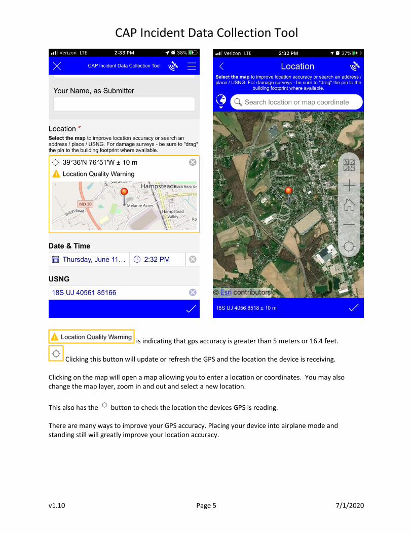
Location This is the specific location where you are standing with you cell phone or tablet. You have the choice to zoom in to the map and select a point. This is important to place the marker in the right location. Our accuracy is requested to be 5 meters or less which is a 16ft radius of accuracy.
CAP Incident Data Collection Tool
v1.10 Page 5 7/1/2020
is indicating that gps accuracy is greater than 5 meters or 16.4 feet.
Clicking this button will update or refresh the GPS and the location the device is receiving. Clicking on the map will open a map allowing you to enter a location or coordinates. You may also change the map layer, zoom in and out and select a new location.
This also has the button to check the location the devices GPS is reading. There are many ways to improve your GPS accuracy. Placing your device into airplane mode and standing still will greatly improve your location accuracy.

CAP Incident Data Collection Tool
v1.10 Page 6 7/1/2020
clicking this button will allow you to see the GPS activity of your device.
Location Information: The location information will also provide you with the United States National Grid (USNG) and the Longitude and Latitude Coordinates. As indicated when calling in coordinates for latitude and longitude you need to ensure that you say the Degrees, Minutes, and Decimal when conveying the coordinates. Coordinates should be read as follows. USNG is read as follows: eighteen S U J four three five three two by eight seven eight six nine. Lat/Long is read as follows, Three nine degrees, three seven decimal five seven eight minutes North seven six degrees, four nine decimal three eight five minutes West. The Date & Time, USNG, and Lat. Long Fields are read only fields.

CAP Incident Data Collection Tool
v1.10 Page 7 7/1/2020
Selecting a waypoint of what you are marking:
This section is very important and we will go through the process of selecting a waypoint. Your team may find itself in a location where more than one submission is needed. These must be entered individually. Your team may find a clue at a location that also has a hazard. These two items must be entered separately. Remember, all of the information being collected is immediately transmitted to the incident commander and others.

CAP Incident Data Collection Tool
v1.10 Page 8 7/1/2020
When selecting a waypoint it will bring up a series of questions and/or the ability to take a photo. The questions are based on CAP, FEMA and USGS standards for Structure Identification or High Water Mark questions. The Question Groupings are: Group 1: CAP Position Update Group 2: ELT/PLB or PLT/Plane Crash Group 3: Clue Location Group 4: Transportation, Route Block Group 5: Flood/Water Hazard or High-Water Mark Group 6: Hazard Items: Electric, Fire, Animal, Hazardous Materials, Hazard Other Group 7: Structure Identification – No Damage, Damaged, Failed, Destroyed Group 8: Incident Command Post markers – IPP/LKP/PLS, Medical Station, ICP, Area Command, Staging, Helo Site, or Other Placeholder.
Group 1: CAP Position Update: This can be used by ground or aircrews.
Submitting a CAP position Update will put a mark on the map with date & time stamp where the activity occurred.

CAP Incident Data Collection Tool
v1.10 Page 9 7/1/2020
Group 2: ELT/PLB or PLT/Plane Crash
When the Team acquires a signal during an ELT or PLB search, the acquisition location needs to be marked along with the signal strength and direction. This is critical because it will allow operations to triangulate the location of the activated device. Each time you do a check it will be a new survey entry. If you find the beacon that will also be a new survey entry by clicking the Yes button. Locating a Beacon - Non-Distress: Clicking yes will bring up another question regarding the Beacon and the Vessel that the Beacon was found in: Populate the fields with all the information you have.

CAP Incident Data Collection Tool
v1.10 Page 10 7/1/2020
Locating a Beacon and Found with Distressed Individual(s): By clicking Beacon Located in a Distress situation it will bring up the vessel information and information for the number of Sole(s) on board. You may have to move the location on the map to the location of the vessel because of safety concerns. Put in the # of Soles on Board, and the status of the Soles, with the Subject Name and Gender. If you put two soles on board your will see a + mark for you to add the additional information for the second Sole. Then Complete the information for the Vessel. Only one entry for the vessel is required. General Comments will come up with the ability to take a photo.

CAP Incident Data Collection Tool
v1.10 Page 11 7/1/2020
Group 3: Clue Location:
Clues are an important part of any search. Do not touch or move a clue unless told so by command.
Group 4: Transportation, Route Block:
To report blocked routes or checking the status of airport Runways, Bridges and Railroad infrastructure. As you are traveling to your task you may come across a blocked route. Reporting that information is greatly helpful in planning routes for other sorties. Emergency Management can use this information to better understand the extent of Damage, better routing of material, equipment and People to support the community impacted. CAP may be specifically asked to conduct Transportation assessments, identify issues in certain areas. However, if your team come across transportation issues while out on other tasking it should be reported using the Survey 123 App.

CAP Incident Data Collection Tool
v1.10 Page 12 7/1/2020
Group 5: Flood/Water/High Water Mark:
This can be used to identify a Flood/Water Hazard and High-Water Mark survey. High-Water Mark Survey is a specific tasking by FEMA or a State Emergency Management Agency. If you are not tasked for High Water Mark you simply select “No” and describe the flood or water hazards. If you are Tasked for a High-Water Mark Survey then you would click Yes and continue to follow the instructions to capture the required information as describe in the survey. Additional details are on the next page. Reference the Guide to Identifying High Water Marks.

CAP Incident Data Collection Tool
v1.10 Page 13 7/1/2020

CAP Incident Data Collection Tool
v1.10 Page 14 7/1/2020
Group 6: Hazard Items – Electrical, Fire, Animal, Hazardous Materials, or Other Identifiable Hazard
This section of the survey is to report Hazards and Debris issues. FEMA or an Emergency Management Agency need to determine the amount of debris and the location for cleanup purposes. For reporting debris use the “Hazard, Other” category, under “Is the hazard Related to Debris”, select “Yes” then select the type of Debris. There is a field for General Comments and it will allow you to add up to 3 photo’s to show the extent of the Hazard you are reporting.

CAP Incident Data Collection Tool
v1.10 Page 15 7/1/2020
Group 7: Structure Identification – No Damage, Damaged, Failed, Destroyed
There are times that CAP is able to deploy quickly to an area before FEMA Urban Search and Rescue Teams (USAR) can be deployed. It is important for FEMA or an Emergency Management Agency to understand the extent of damage to homes or buildings after a Fire, Flood, Hurricane, Tornado, or other event that causes wide spread damage to a community. CAP does not conduct or have the training to complete a true Building Damage Assessment but from a safe distance, we can identify damage to a structure or building by reporting if there is No Damage, Damaged, Failing, or Destroyed. Again, we are only identifying based on a visual look from the street, a safe distance away. We may also look at Utilities, Roads, Bridges, Dams, Railroad, and Airports. This section of the survey will be a specific assignment from FEMA or Emergency Management Agency and you will be given a specific assignment and/or instructions to conduct this type of survey using these symbols. While completing your Identification of Damage you will also assess if the building is occupied, if sheltering is needed, and if debris removal is needed. A photo should be taken of the structure and of the debris that needs to be removed.

CAP Incident Data Collection Tool
v1.10 Page 16 7/1/2020
Group 7: Structure Identification – No Damage, Damaged, Failed, Destroyed – Continued This section has to deal with the Utilities and their function. This is specific to the Structure that you are identifying. If possible, from a safe distance Identify if the Utilities are Functional. If there are downed electrical lines or the smell of gas, withdraw to a safe location and call 911. If Multiple Utilities are out for that structure selecting Multiple will bring up a list and select all that apply. Do’s:
• Verify damage with visual Inspection from Street and at a safe distance.
• Be sensitive discussing damages with property owners.
• Stay in your lane when approached by media. Don’ts:
• Collect any Personally Identifiable Information (PII)
• Drive through flood water or over electric wires
• Visit any sites that would put you in an unsafe situation
• Talk to anyone about something you are unsure about.

CAP Incident Data Collection Tool
v1.10 Page 17 7/1/2020
Group 8: Incident Command Post markers or Description of Location
General Comments and Photos: Here you can put any clarifying comments and information to support the reason for the survey entry. You can also add up to three photographs. It is important that all High-Water Mark Photos are taken within the High-Water Mark Questions section. This is also the same for Clues.