carboniferous stratigraphy of the sierra del brezo in
TRANSCRIPT

Carboniferous stratigraphy of the Sierra del Brezo in northern Palencia: evidence of major uplifts
R.H. Wagner1, and C. F. Winkler Prins2
1 Jardín Botánico de Córdoba, Avenida de Linneo, s/n, 14004 Córdoba, Spain.
2 Nationaal Natuurhistorisch Museum, Postbus 9517, 2300 RA Leiden, The Netherlands.
Recibido el 13 de Octubre de 1998. Aceptado el manuscrito revisado el 31 de Diciembre de 1998.
Abstract: Carboniferous lithostratigraphic units are analysed for the Sierra del Brezo area south ofthe Ruesga Fault at which the northern branch of the Cantabric-Asturian orogen overrides thesouthern branch in northern Palencia. These belong to the Asturian-Leonese facies realm and prolongthe northward facing thrust units of northern León eastwards in the most tightly compressed part ofthe Palaeozoic orogen of the Cantabrian Mountains (Figs. 1, 2). Two subareas are the Valsurbio-Almonga anticlinal structure and the Rebanal-Ventanilla subarea where the axial planes are reversedand considerable shearing took place. As in northern León, the uppermost Famennian - lowermostTournaisian Ermita Formation overlies progressively older Devonian strata northwards with anerosional contact (Fig. 3). The upper Tournaisian to lowermost Namurian Genicera Formation (withthree constituent members) follows all over the area after a generalised stratigraphic break. A 600 to800 m thick development of Namurian “caliza de montaña” (Barcaliente and Valdeteja formations) inthe South passes northwards into much thinner (c. 40-85 m) limestones with a partial (sometimestotal) elimination of the Barcaliente Formation (Figs. 4, 5). Carbonate debris flows and bioclasticlimestones in shales characterise the top of the Valdeteja Formation. An erosional contact separatesthe Valdeteja Limestone Formation in the northern subarea from overlying shales and turbidites ofthe Carmen Formation. The marked stratigraphic breaks noted in the northern subarea match thosefound at exactly the same levels in the Revilla Nappe, some 30 km eastwards in northern Palencia.The Revilla Nappe succession, with low-angle unconformities separating an even thinner ValdetejaFormation (30 m) from Genicera Fm underneath and Carmen Fm above, apparently corresponds tothe same palaeogeographic area characterised by repeated uplift as the northern subarea of the Sierradel Brezo (Fig. 6). It probably represents a strip of terrain suppressed by the Ruesga Fault whichrepresents very considerable tectonic shortening attributable to the pre-Curavacas Palentian phase ofdeformation (dated as late Langsettian).
Key words: Carboniferous, Tournaisian, Viséan, Namurian, Westphalian, Stratigraphy,Palaeogeography.
Resumen: Se analizan las unidades litoestratigráficas del área de la Sierra del Brezo (Palencia) alSur de la Falla de Ruesga donde la rama norte del orógeno cántabro-astúrico cabalga a la rama sur.Pertenecen al dominio astur-leonés y están en continuidad lateral con las estructuras cabalgantes devergencia norte en el Norte de León. Es ésta la parte más apretada del haz de pliegues arqueado delPaleozoico cántabro-astúrico (Figs. 1, 2). Se distinguen dos subáreas, la estructura anticlinal deValsurbio-Almonga en el Sur de la Sierra del Brezo y la subárea de Rebanal-Ventanilla en elNorte, donde los planos axiales están invertidos y existe una laminación tectónica importante.
Al igual que en el Norte de León, la Formación Ermita, del Fameniense superior y Tournaisiensemás inferior, cubre formaciones devónicas cada vez más inferiores hacia el Norte, con un contactoerosivo (Fig. 3). La siguiente formación de Genicera, con sus tres miembros constituyentes, seencuentra como siempre después de un hiato estratigráfico generalizado. Una “caliza de montaña”(Fm Barcaliente y Fm Valdeteja), bien desarrollada (600 a 800 m), comparable al que se conocedel Norte de León, sigue sin hiato aparente en la parte meridional, pero este espesor disminuye de
The arcuate fold belt of the Palaeozoic (pre-Stephanian C) Cantabrian Mountains, which isknown to consist of thrust sheets and nappes directedtowards and molded around a relatively stableforeland spur, the Cantabrian Block of Radig (1962),shows a history of progressive tightening leading toopposing vergencies (compare Pérez-Estaún et al.,1988). Palaeomagnetic measurements by Ries et al.(1980) have shown that the original arcuateconfiguration in c. 60º was modified tectonically tothe present situation which shows strikes changing180º in structures involving Cambrian toCarboniferous strata. Geophysics have confirmed thethin-skinned nature of the tectonic structure in whichthe basement is not involved (Pérez Estaún et al.,1994; Pulgar et al., 1995). Tightening is most severein the eastern part of the Cantabrian Mountains andthis explains the more major extent of thrusting inthis area with large-scale displacement perpendicularto the strike and the development of important nappestructures in northern Palencia, involving a cleardistinction, both stratigraphically and structurally,between autochthon and allochthon (Wagner, 1971).Large-scale tectonic shortening explains thejuxtapostion of areas of different palaeogeographicorigin, showing differences in stratigraphicdevelopment. Nowhere is this more apparent than innorthern Palencia where a major fault line, theRuesga Fault of Kanis (1956), separates the northernbranch of the Cantabric-Asturian tectonic orogenfrom the southern branch, with the former overridingthe latter (Fig. 1). This major fault line has had acomplicated history with different kinds ofdisplacement at different times, from early
Westphalian into Cretaceous/Tertiary, but its mostimportant effect is apparent from the opposingvergencies, with the northward facing Palaeozoicstructures of the Sierra del Brezo being cut off byNNW-ESE striking thrust units facing south (Fig. 2).At this fault line two quite different facies areasmeet, i.e. the Asturian-Leonese and Palentian faciesareas, which are most apparent in Middle and UpperDevonian strata (Brouwer, 1964a, b; see also García-Alcalde et al., 1988), but which also show a ratherdifferent development for the Carboniferous (Wagneret al., 1983). This obvious facies difference was oneof the main reasons for De Sitter (1961) to propose a“León Line” as a fundamental fracture zoneseparating two different areas of sedimentation.Although he based his “León Line” primarily on theRuesga Fault, he linked this fault to one of similarcharacteristics in northern León. (For a discussion ofthe León Fault see Marcos, 1968.) The concept of aLeón “Line” implies a fundamental fractureinvolving the basement which is alien to the tectonicstructure of the Palaeozoic Cantabrian Mountains.Although the “León Line” is still occasionallyinvoked (e.g. Kullmann and Schönenberg, 1978, in apaper criticised by Marcos, 1979), the concept isgenerally allowed to lapse. Although the RuesgaFault produced a line of weakness subsequentlyexploited by Mesozoic movements (compareWagner et al., 1984, and Espina et al., 1996), theoriginal fault seems to have been a thrust leading tovery severe tectonic shortening. The different historyof Carboniferous strata south and north of theRuesga Fault has been investigated by the presentwriters for about a decade, with major emphasis on
386 R. H. WAGNER AND C. F. WINKLER
modo espectacular hacia el Norte donde se llega a un máximo de 85 m (Figs. 4, 5) y unaeliminación parcial y a veces total de la Fm Barcaliente. El techo de la Formación Valdetejamuestra a menudo el desarrollo de debris flow calcáreos. Un contacto erosivo separa la FmValdeteja de las lutitas y turbiditas siliciclásticas de la Fm Carmen. Los mismos hiatosestratigráficos señalados en la subárea norte de la Sierra del Brezo se encuentran en el Manto deRevilla, unos 30 km más al Este en la misma provincia de Palencia, donde están asociados adiscordancias poco angulares y donde la sucesión estratigráfica está aún más disminuida (sólo unmáximo de 30 m para la Fm Valdeteja). Se interpreta que el Manto de Revilla representa unaparte aún más al Norte de la misma área paleogeográfica caracterizada por levantamientosrepetidos en los tiempos carboníferos mencionados, y que se insertaría en la franja de terrenoeliminado por la Falla de Ruesga que representa un acortamiento tectónico muy importante. Estafalla es de edad Langsettiense (pre-Conglomerado de Curavacas).
Palabras clave: Carbonífero, Tournaisiense, Viséense, Namuriense, Westfaliense, Estratigrafía,Paleogeografía.

the more poorly known area north of the fault.Stratigraphic dating relied mainly on conodonts,studied by M. van den Boogaard in Leiden, moreincidental foraminiferal sampling by E. Villa(Oviedo), and occasional finds of goniatites. Thepresent paper focuses on the stratigraphicdevelopments south of the Ruesga Fault, an areawhich has been the subject of recent work by Marínet al. (1996) and Marín (1997), whose conclusionsand interpretations do not always agree with the fieldobservations and perceptions of the present writers(compare Wagner and Winkler Prins, 1997).
Geological outline of the Sierra del Brezo
This area south of the Ruesga Fault was mappedinitially by Quiring (1939) and Kanis (1956)followed by Koopmans (1962), who described a
large anticlinal structure in the southern part of thismountainous area as the Valsurvio Dome, amisnomer which was maintained by later authors.This structure, which can be matched in northernLeón by a similar change from southward dipping,northward facing thrust units to northward facingunits with a reversed dip, is probably the same as thatdescribed by Kanis (1956) as the Almonga Anticline(Fig. 2). The reversal of the dip in the northern partof the Sierra del Brezo, leading to northerly dips of25º to 50º (usually around 25º-40º N), has provokedthe local elimination of strata due to shearing whichhas led to lenticular occurrences of the thinnerformations. In the Valsurbio-Almonga anticlinalstructure and in thrust slices in the area near Rebanalde las Llantas, San Martín de los Herreros, andVentanilla, in the northern part of the Sierra delBrezo, a succession of Middle and Upper Devonian
CARBONIFEROUS STRATIGRAPHY OF THE SIERRA DEL BREZO IN NORTHERN PALENCIA: EVIDENCE OF MAJOR UPLIFTS 387
Fig. 1. Tectonic sketch of the Cantabrian Mountains showing the turnaround of vergencies (arrows) and major thrust faults at which tectonicshortening occurred as an accommodation to tightening of the arcuate fold belt. The Ruesga Fault, of early Westphalian age, is the earliest andmost major of these thrust faults. This important tectonic fracture was reactivated in different ways in later, partly Mesozoic-Tertiary times.Stippled area: Permian-Mesozoic-Tertiary cover.

strata crops out with characteristics which allow adirect comparison with the formations described byComte (1959) for northern León (Wagner et al.,1984; Marín, 1997). Although acknowledging thesimilarity, a different set of formational names wasintroduced by Koopmans (1962) for the Sierra delBrezo. These names were adopted by Savage (1977)for a mapping synthesis in which he included themaps produced by Kanis (1956) and Koopmans(1962). Similarly, Lobato et al. (1985) employedthese formational names which seem to represent anunnecessary proliferation of local stratigraphicnames, and which imply a negation of the readilyapparent lateral continuity of the Sierra del Brezowith northern León. The only one of Koopmans’sformations that may be kept as a convenient unit, isthe Camporredondo Quartzite Formation at the topof the Devonian succession in the southern andeastern parts of the Sierra del Brezo, where it has notyet been possible to separate the Nocedo SandstoneFormation from the overlying Ermita SandstoneFormation. On the other hand, the Ermita Formationcan be distinguished unequivocally as a separate unitin the general vicinity of San Martín de los Herreros,where this upper Famennian-lower Tournaisianformation overlies Givetian limestones of the PortillaFormation with a clearly erosional contact (Fig. 3).The different contacts correspond to the lateFamennian uplift described by Comte (1938) andsubsequent authors.
The southward dipping, northward facingstructures on the southern flank of the Valsurbio-Almonga Anticline (Fig. 2) coincide with a 600 to800 m thick development of Namurian limestone,traditionally referred to as “caliza de montaña”,which follows upon a relatively thin formation ofsiliceous shales and nodular limestones. This isthe Genicera Formation of Wagner et al., 1971(also called Villabellaco Formation or AlbaFormation, depending on the different authors). Amuch thinner development of “caliza de montaña”(40 to 85 m) occurs in the northern part of theSierra del Brezo (see Fig. 5) where upliftprovoked the removal of most of the lower part ofthe limestone (Barcaliente Formation) andprobable non-deposition of some of the higher part(Valdeteja Formation). This is interpreteddifferently by Marín et al. (1996) and Marín
(1997), who adopts the term Brezo Limestone,used informally by Reuther (1982), for the “calizade montaña” in the Rebanal-San Martín subarea.Marín (1997) records alternate thinly bedded(Barcaliente) and more massively bedded(Valdeteja) facies which the present writersattribute to small scale tectonic repetition such asoccurs in a thrust slice south of San Martín de losHerreros. Where less tectonised sections occur(uncommonly) it proves possible to distinguishbetween Barcaliente and Valdeteja formations, itbeing understood that thinly bedded limestonesmay be found intercalated between more massive,sometimes clearly bioclastic limestones in theValdeteja Formation. The Barcaliente Formation isuniformly thinly bedded.
There is an apparently gradual contact between thethick limestone development (ValdetejaFormation) and overlying mudstones in thesouthern flank of the Valsurbio Anticline whereProshumardites morrowanus Gordon (C. H. T.Gentis, det.) has been found in mudstones exposednorth of Villafría (loc. 2676). This goniatite of theMorrow (lower Pennsylvanian) of Arkansas,U.S.A. (Gordon, 1964), suggests a mid to lateNamurian age. In the northern part of the Sierradel Brezo the Valdeteja Limestone Formation,much diminished in thickness, shows carbonatedebris flows in shales at the top of the formation, afacies development that is not uncommon at thetop of this formation in northern León. Anerosional contact separates these strata fromseveral hundred metres of overlying shales andsandstones, generally of a turbiditic nature. This isthe Carmen Formation which is called the CerveraFormation by Marín et al. (1996), using a latersynonym (as explained by Wagner et al., 1984).
The initial mapping by Kanis (1956) andKoopmans (1962), used for the regional synthesisat 1:50,000 scale by Savage (1977), wassuperseded by the work of Pulgar (1973), whichwas incorporated in the general overview at100,000 scale published by Lobato (1977) andalso in the Geological Survey map to the scale of1:50,000 (Camporredondo sheet) published byLobato et al. (1985). The adjacent GeologicalSurvey map (Barruelo sheet) produced by Wagneret al. (1984) includes the eastern end of the Sierra
388 R. H. WAGNER AND C. F. WINKLER

del Brezo structural area. Wagner et al. (1984)emphasised the significance of the Ruesga Faultwhich they regarded as representing majortectonic shortening. It is noted that the Barrueloand Camporredondo map sheets render thegeological structure of the Sierra del Brezo morereliably than that published by Savage (1977).Finally, the unpublished map by Marín (1997),also to the 1:50,000 scale, provides a moredetailed picture of the geological structures in theSierra del Brezo, although the complexity of thisarea still requires mapping to a smaller scale.Some of the earlier map data were overlooked byMarín, as is apparent from an illustration in histhesis where the Carboniferous strata underlyingunconformable Cretaceous conglomerates areshown as “Grupo Cea” (here meant to representupper Westphalian D), whereas these belong infact to the Carmen Formation (compare theBarruelo sheet by Wagner et al., 1984). Marín
(1997) emphasises the Mesozoic role of theRuesga Fault rather than its importance for thePalaeozoic structures, which the present writersregard as more significant. The trace of theRuesga Fault, which delimits the first southwardfacing thrust slice north of the Sierra del Brezostructural area is not everywhere shown accuratelyon Marín’s map. The Devonian and Carboniferousstrata in the general area of the Sierra del Brezoare bordered to the south by an angularunconformity with upper Westphalian D marineand coal-bearing deposits of the Guardo-CerveraCoalfield. This contact is partly tectonised, but thefaulting is relatively minor and partly within theupper Westphalian D and lowermost Cantabrianstrata above the unconformity, as is shown on anunpublished 1:10,000 map of the Guardo-CerveraCoalfield which is on open file in the InstitutoTecnológico Geominero in Madrid as part of areport by the Empresa Nacional Adaro de
CARBONIFEROUS STRATIGRAPHY OF THE SIERRA DEL BREZO IN NORTHERN PALENCIA: EVIDENCE OF MAJOR UPLIFTS 389
Fig. 2. Tectonic elements of the northward verging structural area of the Sierra del Brezo in northern Palencia, containing Devonian andCarboniferous (up to lower Westphalian) strata of Asturian-Leonese facies. It is delimited to the north by the Ruesga Fault, originally asouthward directed thrust at which the southward verging Palentian area overrides the Asturian-Leonese area. It is delimited to the south byunconformable upper Westphalian D and lower Cantabrian strata of the Guardo-Cervera Coalfield. Outline based partly on the map of Marín(1997), with modifications. Broken lines with black triangles are southward directed thrust faults of the Palentian area; broken lines with simplecross lines represent northward directed thrust faults of the Asturian-Leonese area (Sierra del Brezo).

Investigaciones Mineras (see also Wagner andFernández-García, 1983, 1984).
Discussion of the Carboniferous succession
In the Sierra del Brezo the Middle and UpperDevonian deposits corresponding to the SantaLucía, Huergas, Portilla and Nocedo formationsare followed by the Ermita Sandstone Formation,which is mainly late Famennian in age but whichreaches into the lower Tournaisian (Raven, 1983).
This is followed by the Genicera Limestone andShale Formation, the Barcaliente LimestoneFormation (mainly eliminated by uplift in thenorthern part of the area), the Valdeteja LimestoneFormation, and the Carmen Shale and SandstoneFormation of turbiditic characteristics.
Ermita Sandstone Formation
In the Valsurbio-Almonga Anticline and in theeastern part of the anticlinal structure of Ventanilla
390 R. H. WAGNER AND C. F. WINKLER
Fig. 3. Erosion surface (palaeokarst?) on Portilla Limestone (Devonian) filled in by sandstones of the Ermita Formation (Famennian-lowerTournaisian). Note limestone blocks in the sandstone fill. Exposures at 1,800 m east of Rebanal de las Llantas.

(Fig. 2), the Ermita Sandstone Formation has notbeen distinguished from the Nocedo SandstoneFormation, and has been incorporated with theCamporredondo Quartzite Formation of Koopmans(1962). However, in the northern part of the Sierradel Brezo, in the region of Rebanal de las Llantasand San Martín de los Herreros, the ErmitaFormation rests upon Givetian limestones of thePortilla Formation, and is clearly delimited at itsbase by an erosional contact (Fig. 3). Also in thearea southwest of La Lastra, near theCamporredondo reservoir, a similar contactbetween Portilla limestone and coarse sandstones ofthe Ermita Formation allows the latter to bedistinguished without ambiguity. A magnificentexposure near the main road about halfway Rebanaland San Martín shows a well-developed erosionsurface on top of the limestone, i.e. a palaeokarstsurface with a hollow of 5 to 6 m depth and theremains of a limestone breccia plastered onto thesides of the hollow (Fig. 3). A thinly beddedsandstone fills in the hollow as a strictly localdeposit. It is followed by 4 m of coarse-grainedsandstone with occasional small pebbles, whichonlaps on the sides of the erosional hollow. Sandylimestone, 0.50 m thick, follows in succession.Another 0.20 m of coarse-grained quartzosesandstone constitutes the top part of the ErmitaFormation in this important locality. A sharpcontact separates this formation from 6.80 m ofmainly grey nodular limestone with some reddishmottling, representing the Genicera Formation.Shearing has eliminated the middle part of thisformation in the locality described (Fig. 4-I). TheGenicera limestones are followed by c. 20 m ofmassive-bedded grey limestones, partly of abioclastic nature, which are attributed to theValdeteja Formation.
Within the same structural unit, but further towardsRebanal de las Llantas, a section occurs with 1.40m of coarse-grained quartz sandstone of the ErmitaFormation (Fig. 4-II). Although the contact withthe underlying Portilla Limestone Formation isexposed in this section, the exposure is notsufficiently large to show the irregularities of anerosional surface. The relatively thin developmentof sandstone of the Ermita Formation suggests thatonly the top part of this formation is represented
here as a result of onlap on the higher part of apalaeotopography.
At c. 1100 m south of San Martín de los Herreros asmall cross-fold in Portilla Limestone Formation,Ermita Formation, and Genicera Formation allowsfurther stratigraphic observations. This locality(Fig. 4-III) shows 2 m of coarse-grained sandstonewith occasional small pebbles lying on top ofPortilla Limestone with a sharp contact. It isfollowed by 1.80 m of sandy, bioclastic limestone,and this is succeeded in turn by 1.40 m of coarse-grained sandstone. This succession is the oneshown by Raven (1983, fig. 20), who mentions thecostatus conodont zone of the highest Famennianand the Polygnathus fauna of the basalTournaisian, but without citing the faunal contents.Famennian conodonts were also obtained from thislocality by A. C. Higgins (pers. comm.) and alower Tournaisian Polygnathus faunacorresponding to the Gattendorfia goniatite zoneby M. van der Boogaard (pers. comm):Polygnathus communis communis Branson andMehl, 1934; P. inornatus inornatus Branson, 1934;P. purus purus Voges, 1959; P. purus subplanusVoges, 1959; P. longiposticus Branson and Mehl,1934; Polygnathus sp.; Pseudopolygnathustriangulus inaequalis Voges, 1959; P. dentilineatusBranson, 1934; P. cf. brevipennatus Ziegler, 1962;Pseudopolygnathus sp.; Bispathodus aculeatusaculeatus Branson and Mehl, 1934;Spathognathodus crassidentatus Branson andMehl, 1934; Spathognathodus sp.; Ozarkodina sp.;ramiform elements; bryozoan remains; fish teethand placoid scales.
Fig. 4 depicts variations in the occurrence of theErmita Formation as described above.
Genicera Limestone and Shale Formation
This formation occurs commonly in the Sierra delBrezo, but is generally found incomplete as a resultof shearing within thrust slices or because itfunctioned as a detachment horizon at the base ofsubsidiary thrust units. However, an apparentlycomplete succession has been found in a hillside atc. 1 km ESE of Rebanal de las Llantas.Complementary data were collected in the same
CARBONIFEROUS STRATIGRAPHY OF THE SIERRA DEL BREZO IN NORTHERN PALENCIA: EVIDENCE OF MAJOR UPLIFTS 391

392 R. H. WAGNER AND C. F. WINKLER
Fig. 4. Stratigraphic sections at scale 1:200 of Ermita and Genicera formations, showing variations in relation to the palaeotopography filled inby the Ermita Formation. I. At 1,800 m east of Rebanal de las Llantas. II. At c. 1 km ESE of Rebanal. III. At 1,100 m south of San Martín delos Herreros.
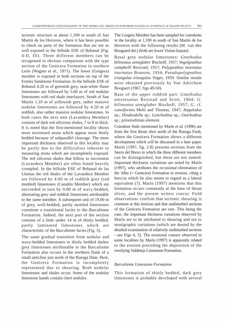
tectonic structure at about 1,100 m south of SanMartín de los Herreros, where it has been possibleto check on parts of the formation that are not sowell exposed in the hillside ESE of Rebanal (Fig.4-II, III). Three different members can berecognised in obvious comparison with the typesection of the Genicera Formation in northernLeón (Wagner et al., 1971). The lower (Gorgera)member is exposed in both sections on top of theErmita Sandstone Formation. In the hillside ESE ofRebanal 4.20 m of greenish grey, near-white flaserlimestones are followed by 5.60 m of red nodularlimestones with red shale interlayers. South of SanMartín 1.10 m of yellowish grey, rather massivenodular limestones are followed by 4.50 m ofreddish, also rather massive nodular limestones. Inboth cases the next unit (Lavandera Member)consists of dark red siliceous shales, 7 to 8 m thick.It is noted that the first-mentioned locality showsmore tectonised strata which appear more thinlybedded because of subparallel cleavage. The moreimportant thickness observed in this locality maybe partly due to the difficulties inherent tomeasuring strata which are incompletely exposed.The red siliceous shales that follow in succession(Lavandera Member) are often found heavilycrumpled. In the hillside ESE of Rebanal de lasLlantas the red shales of the Lavandera Memberare followed by 4.60 m of reddish grey (redmottled) limestones (Canalón Member) which aresucceeded in turn by 0.80 m of wavy-bedded,alternating grey and reddish limestones attributableto the same member. A subsequent unit of 19.00 mof grey, well-bedded, partly mottled limestonesconstitute a transitional facies to the BarcalienteFormation. Indeed, the next part of the sectionconsists of a little under 14 m of thinly bedded,partly laminated limestones which arecharacteristic of the Barcaliente facies (Fig. 5).
The same gradual transition from nodular andwavy-bedded limestones to thinly bedded darkergrey limestones attributable to the BarcalienteFormation also occurs in the northern flank of asmall anticline just north of the Ruesga Dam. Here,the Genicera Formation is incompletelyrepresented due to shearing. Both nodularlimestones and shales occur. Some of the nodularlimestone bands contain chert nodules.
The Gorgera Member has been sampled for conodontsin the locality at 1,100 m south of San Martín de losHerreros with the following results (M. van denBoogaard det.) (both are lower Viséan faunas):
Basal grey nodular limestones: Gnathodusbilineatus semiglaber Bischoff, 1957; Vogelgnathuscampbelli Rexroad, 1957; Polygnathus inornatusinornatus Branson, 1934; Pseudopolygnathustriangulus triangulus Voges, 1959. Similar resultswere obtained previously by Van AdrichemBoogaert (1967, figs 49-50).
Base of the upper reddish part: Gnathodusantetexanus Rexroad and Scott, 1964; G.bilineatus semiglaber Bischoff, 1957; G. cf.cuneiformis Mehl and Thomas, 1947; Angulodussp.; Hindeodella sp.; Lonchodina sp.; Ozarkodinasp.; prioniodinian element.
Conodont finds mentioned by Marín et al. (1996) arefrom the first thrust slice north of the Ruesga Fault,where the Genicera Formation shows a differentdevelopment which will be discussed in a later paper.Marín (1997, fig. 2.8) presents sections from theSierra del Brezo in which the three different memberscan be distinguished, but these are not named.Important thickness variations are noted by Marín(1997), who attributes the occasional elimination ofthe Alba (= Genicera) Formation to erosion, citing abreccia which he also seems to regard as a lateralequivalent (?). Marín (1997) mentions that thisformation occurs commonly at the base of thrustslices, and the present writers concur. Fieldobservations confirm that tectonic shearing iscommon at this horizon and that undisturbed sectionsof the Genicera Formation are rare. This being thecase, the important thickness variations observed byMarín are to be attributed to shearing and not tostratigraphic variations (which are denied by thedetailed examination of relatively undisturbed sections- see Figs 4, 5). The erosional contact observed insome localities by Marín (1997) is apparently relatedto the erosion preceding the deposition of theoverlying Valdeteja Limestone Formation.
Barcaliente Limestone Formation
This formation of thinly bedded, dark greylimestones is probably developed with several
CARBONIFEROUS STRATIGRAPHY OF THE SIERRA DEL BREZO IN NORTHERN PALENCIA: EVIDENCE OF MAJOR UPLIFTS 393
394 R. H. WAGNER AND C. F. WINKLER
Fig. 5. Stratigraphic sections at scale 1:500 of Genicera, Barcaliente, and Valdeteja formations in the northern part of the Sierra del Brezo. I. At c.1 km ESE of Rebanal de las Llantas. II. At 2,200 m south of San Martín de los Herreros.

hundred metres thickness in the southern part of theSierra del Brezo (southern flank of the ValsurbioAnticline), but cannot be identified here onlithological characters due to recrystallisation andjointing. In the northern part of the Sierra delBrezo, i.e. in the region of Rebanal de las Llantasand San Martín de los Herreros, the BarcalienteFormation is poorly represented due to uplift anddiscontinuity below the subsequent ValdetejaLimestone Formation. Marín (1997) shows theBarcaliente Formation to be present in the vicinityof Ventanilla and in structures WNW of San Martínde los Herreros, but these strata apparently belongto the first thrust slice north of the Ruesga Fault.They thus represent a different palaeogeographicalarea, where transitional facies were developedbetween the Barcaliente Limestone Formation ofthe Asturian-Leonese facies and a somewhatdifferent, more shallow water limestone which isdeveloped characteristically in thrust slices of thePalentian area. Up to 80 m of well bedded, bluishgrey limestones have been measured by the presentwriters in different localities of the first thrust slicenorth of the Ruesga Fault (e.g. at La Lastra).Conodont faunas from this limestone range in agefrom late Viséan-earliest Namurian to Chokierian(M. van den Boogaard and T. Nemirovskaya, pers.comm.). The Palentian facies and structural areanorth of the Ruesga Fault will be dealt with morefully in a later paper.
This 80 m thickness is rather more than isrepresented in the northern part of the Sierra delBrezo near San Martín de los Herreros and Rebanalde las Llantas. In the section at c. 1 km ESE ofRebanal de las Llantas (Fig. 5-I), south of theRuesga Fault, only about 14 m of limestone areclearly attributable to the Barcaliente Formation. Inthis section the Barcaliente limestone is overlain bynodular limestones which are shown as a repetitionof Alba (= Genicera) Formation by Marín (1997:map), and these are in sharp contact with massivelybedded, light grey limestones of the ValdetejaFormation. The possibility of a tectonic repetition ofthe upper part (Canalón Member) of the GeniceraFormation is lessened by the fact that theBarcaliente Formation is not repeated, which issurprising given the close proximity. However, thegeneralised erosion prior to the Valdeteja Limestone
deposition in the Rebanal-Ventanilla subarea makesthe elimination of Barcaliente Limestone Formationin a subsequent (small) thrust slice a distinctpossibility, which conodont work in progress shouldbe able to resolve in the near future. The originalthickness of the Barcaliente Formation in thenorthern part of the Sierra del Brezo cannot beestablished, since an early uplift may well have beenaccompanied by non-deposition. However, thepresence of 600 to 800 m of undifferentiatedBarcaliente and Valdeteja limestones in the southernflank of the Valsurbio Anticline, in the southern partof the Sierra del Brezo, suggests that the BarcalienteLimestone Formation in this part of the general areamay have been hundreds of metres thick originally(as in northern León). No direct dating of theBarcaliente Formation south of the Ruesga Fault isavailable as yet, but its gradational contact with theunderlying Genicera Formation makes an earlyNamurian age most likely.
Marín (1997) admits the presence of theBarcaliente Formation in the general vicinity ofSan Martín de los Herreros, but places it on top ofhis Brezo Limestone in the stratigraphic columnsof his fig. 2.11. This position of the BarcalienteFormation is anomalous with regard to the generalinformation on this lithostratigraphic unit in theCantabrian Mountains, and the direct observationof stratigraphic sections in the Sierra del Brezo bythe present writers does not support Marín’sinterpretation.
Valdeteja Limestone Formation
The characteristic facies of this formation asdescribed from northern León (Wagner et al.,1971) is that of light grey, massive-beddedlimestones with scattered crinoid debris. However,darker more thinly bedded limestones are foundintercalated, and a full range of shallow waterlimestones may be present. In the absence of aproper facies analysis backed by thin section work,the presence of light grey, massive and massivelybedded limestones with occasional crinoid debrischaracterises the formation. Reuther (1977)described the presence of a limestone breccia at thebase of the massively bedded limestones in theSierra del Brezo, using the terms Brezo Breccia
CARBONIFEROUS STRATIGRAPHY OF THE SIERRA DEL BREZO IN NORTHERN PALENCIA: EVIDENCE OF MAJOR UPLIFTS 395

and Brezo Limestone, which were adopted byMarín et al. (1996) and Marín (1997). A directcomparison with northern León was made byWagner et al. (1983) and Wagner et al. (1984),who identified the Valdeteja Formation. Theypointed out that the Valdeteja Formationsometimes overlies the Genicera Formationdirectly in (the northern part of) the Sierra delBrezo, but that a thin remnant of BarcalienteFormation is found in part of the (sub)area. This isascribed to uplift and erosion which eliminatedmost if not all of the Barcaliente Formation.Erosion is also admitted by Reuther (1982).
The Valdeteja Formation is recognisably presentwith a thickness of 400-500 m of limestone in thesouthern flank of the Valsurbio Anticline, where itis fully exposed in the road to the sanctuary ofNuestra Señora del Brezo, north of Villafría. It thinsmarkedly northwards, and in the area of Rebanal delas Llantas and San Martín de los Herrerosthicknesses of 40 to 85 m have been measured,including the carbonate debris flows in shales at thetop of the formation (Fig. 5). This probably meansthat sedimentation set in again at slightly differenttimes after the movements of uplift whicheliminated most and in some parts of the northernsubarea all of the Barcaliente Formation.
At the base of the Valdeteja Formation in thenorthern part of the Sierra del Brezo there is oftena breccia which corresponds to the Brezo Brecciaof Reuther (1977). Although commonly present, itis laterally discontinuous. Marín et al. (1996)record this breccia also from the first thrust slicenorth of the Ruesga Fault (their “Lámina de losArroyos”), but an examination of the exposures inthis thrust slice has shown this record to be inerror. Their highly diagrammatic section (Marín etal., 1996, fig. 3 - column III) is misleading(Wagner and Winkler Prins, 1997), and althoughMarín et al. (1997) reply that this breccia occursnot in the published section but elsewhere in thesame thrust slice, a detailed examination of theexposures has failed to yield proof of thecorrectness of this assertion. In fact, the BrezoBreccia seems to be absent in the area north of theRuesga Fault, where the stratigraphic developmentis rather different, also for the Carboniferoussuccession below the Carmen Formation.
The top of the Valdeteja Formation in the northernpart of the Sierra del Brezo shows carbonate debrisflows and bioclastic limestones alternating withshales in a number of localities. This suggests thatshallow carbonate platform areas were swept ofbioclastic debris and released limestone blocks andrubble from the margins in order to becomeincorporated into a more low-lying mud basin.Carbonate debris flows are also known from the topof the Valdeteja Formation in northern León, wherethis carbonate formation ends at differentstratigraphic levels. From a locality at some 500 msouth of Rebanal de las Llantas, in the northern partof the Sierra del Brezo, Villa (in Marín et al., 1996)recorded a small foraminiferal fauna from alimestone band in shales at the top of the ValdetejaFormation. This fauna was identified asTashastinsky Horizon of the basal upper Bashkirian,i.e. approximately middle to upper Namurian.Although Marín et al. (1996) attributed thislimestone band to the overlying Carmen Formation(mentioned as Cervera Formation in their paper), anexamination of their locality shows that theirregularly developed carbonate debris flows andbioclastic limestones in shales are linked to theValdeteja Limestone Formation. Indeed, the top ofthe limestone shows debris flow streamers comingoff the limestone. A similar development oflimestone bands showing carbonate debris flowswithin shales, is found at the top of the ValdetejaFormation at some 200 m south of the Ruesga Damsite. In the latter locality these limestones and shalesare cut by an irregular erosion surface cutting downto different levels, and with hollows in thelimestones showing shapes suggesting a palaeokarstsurface. Limestone breccia has not been preserved,presumably because it was washed out whenflooded at the commencement of marinesedimentation of the Carmen Formation afterwards.Calcite deposits associated with the apparentpalaeokarst surface fit the interpretation. Subsequentdeposits in this locality are well exposed shales withfine-grained turbiditic sandstone bands with solemarkings including groove and tool marks as well asbiogenic markings. These belong to the CarmenFormation, which is widely developed both southand north of the Ruesga Fault, and which is instantlyrecognisable on facies characteristics.
396 R. H. WAGNER AND C. F. WINKLER

A section at 2,200 m south of San Martín de losHerreros (Fig. 5-II) shows a sharp contact betweennodular limestones of the Genicera Formation andan 88 m thick succession attributable to theValdeteja Formation. This commences with 33 mof grey, bedded limestones (20 to 30 cm beddinginterval), followed by 16 m of grey massivelimestone, continued by another 20 m of greybedded limestone with at least one bed containingcrinoid debris and 2 m of bioclastic limestone atthe top unit; this is brecciated in the upper 70 cm.Successive deposits are 19 m of shales alternatingwith carbonate debris flows. A sharp contactseparates these rocks attributed to the ValdetejaFormation from cross-bedded sandstones withshale intercalations which may be assigned to theCarmen Formation. The two sharp contactsobserved apparently correspond to stratigraphicbreaks between the different formations (Fig. 5-II;compare Fig. 6).
Since Marín et al. (1996) interpreted thelimestone/shale succession at the top of thelimestone south of Rebanal de las Llantas asbelonging to the overlying Cervera (= Carmen)Formation, they attributed a Baskirian age to thelatter. The arbitrary nature of this interpretation waspointed out to them privately before their paper waspublished, and subsequently in Wagner and WinklerPrins (1997). However, Marín (1997) continues toascribe this part of the succession to the Cervera (=Carmen) Formation. He consequently concludesthat there is stratigraphic continuity between thisformation and the underlying limestone. It hasalready been explained that a sharp contact is foundbetween the limestone-shale succession with debrisflows at the top of the limestone and the overlyingshale-turbidite succession, and that this contact is aclearly erosional one in at least one locality withfull exposure. Marín et al. (1996) have thus datedthe top of the limestone (here identified as theValdeteja Formation), and not the overlying shale-turbidite succession (Carmen Formation) which isundated here.
Carmen Sandstone and Shale Formation
This formation was originally described from theRevilla Nappe in the vicinity of Barruelo de
Santullán (Wagner and Wagner-Gentis, 1963;Wagner, 1971), where the succession of strata andthe stratigraphic breaks observed in this successioninvite comparison with the northern part of theSierra del Brezo (Wagner et al., 1983). A latersynonym is the Cervera Formation which wasintroduced by Brouwer and Van Ginkel (1964) forthe same succession of strata near Cervera dePisuerga, north of the Ruesga Fault (compareWagner et al., 1984). The Carmen Formationoccurs both north and south of the Ruesga Faultwith the same lithological characteristics whichinclude quartzite conglomerate lenses as well asturbidites. A thickness of up to 1,100 m is recordednorth of the fault (Wagner et al., 1984), and severalhundred metres of thickness are known to occur inthe Sierra del Brezo. Since this is the highestformation known prior to the completelyunconformable Curavacas ConglomerateFormation, the recorded thickness is likely to beless than that originally present. This formationoverlies the Valdeteja Limestone Formation with asharp contact (Fig. 5) which is clearly erosional inthe locality south of the Ruesga Dam site, south ofthe Ruesga Fault. North of the fault it overlies thelower Moscovian Perapertú Formation, also withan erosional contact (see Wagner et al., 1983 andWagner et al., 1984).
Summary of the Carboniferous succession
In the northern part of the Sierra del Brezo a thindevelopment of Ermita Sandstone and Limestoneoverlies different formations of the Devoniansuccession with a markedly erosive contact (Figs 3,4). This is followed after an stratigraphic break bylimestones and shales of the Genicera Formationwhich can be subdivided into the Gorgera,Lavandera, and Canalón members, as in northernLeón. The overlying Barcaliente Formation of thinlybedded, dark grey limestones, often with internallamination, occurs in gradual transition. In theRebanal-San Martín-Ventanilla subarea, thesubsequent Valdeteja Limestone Formation variouslyoverlies beds of the Genicera Formation or a thinremnant of the Barcaliente Formation. At and nearthe base of the Valdeteja Formation one often finds alimestone breccia, the Brezo Breccia of Reuther
CARBONIFEROUS STRATIGRAPHY OF THE SIERRA DEL BREZO IN NORTHERN PALENCIA: EVIDENCE OF MAJOR UPLIFTS 397

(1977). The Valdeteja Formation is developed with400 to 500 metres thickness in the southern part ofthe area, in the southern flank of the ValsurbioAnticline, whereas a much thinner development, 40to 85 m thick, is present in the northern part of theSierra del Brezo. Carbonate debris flows in shalesare commonly found at the top of the ValdetejaFormation and it is from this part of the successionthat an upper Bashkirian (Tashastinsky) foraminiferalfauna has been recorded by Marín et al. (1996). Anerosional surface corresponding most likely to awashed-out palaeokarst in at least one locality isassociated with the top of the Valdeteja Formation,which is overlain by shales and turbidites includingquartzite conglomerate lenses of the CarmenFormation. The different thicknesses and the positionof stratigraphic breaks are indicated in the diagramof Fig. 6.
Comparison with the Revilla Nappe
The major breaks in the stratigraphic succession ofCarboniferous rocks in the northern part of theSierra del Brezo are matched by those found in theRevilla Nappe SSW of Barruelo de Santullán, innortheastern Palencia (Wagner, 1971). In this nappestructure of southern derivation a remnant of aGivetian succession of limestones, sandstone andshales, 15.5 m thick, is overlain with angularunconformity by nodular and wavy-beddedlimestones of the Genicera Formation (Gorgera andCanalón members; the Lavandera Member is notdeveloped here), which has yielded conodont andgoniatite faunas of late Tournaisian to late Viséanages (Higgins and Wagner-Gentis, 1982) and whichreaches into lower Namurian Pendleian Stage in thehead of the nappe (Wagner-Gentis, 1980). A low-angle unconformity separates the GeniceraLimestone Formation from the overlying ValdetejaLimestone Formation which has a preservedthickness of 30 m and which grades laterally into acarbonate debris flow deposit. Van Ginkel (1965)obtained Bashkirian foraminifera from the debrisflow limestones. There is no sign of the BarcalienteFormation which was probably removed by uplift.Another angular unconformity underlies thesubsequent Carmen Shale and SandstoneFormation, which cuts down variously to Valdeteja
Formation and Genicera Formation as the low-angle unconformable contact is followed along thestrike. A well-developed palaeokarst has beenrecorded at the contact between GeniceraFormation and Carmen Formation in the exposureof the head of the nappe (Wagner, 1971) as well asin the main outcrop of the nappe structure. Apinnule of Linopteris found in shales in thelowermost part of the Carmen Formation suggestsan age not earlier than Westphalian (op. cit.). Aseparate exposure (small klippe) of the Revillanappe structure shows breccia with goniatite-bearing angular clasts of the Genicera Formation.This is comparable to the Brezo Breccia.
All the evidence points to an area of repeated upliftwith stratigraphic breaks at the same levels asrecorded in the northern part of the Sierra del Brezo(Wagner et al., 1983), but with more angularcontacts and a more considerable removal of strata.Since the southern part of the Sierra del Brezocontains a more complete succession of strata, andthe unconformities are developed similarly in thenorthern part of the Sierra del Brezo, the RevillaNappe should be assigned a relative position whichis close to the latter, although presumably a littlefurther north, corresponding to an area of moreconsiderable uplift (Fig. 6). The tectonic shorteningassociated with the Ruesga Fault, along the line ofwhich the northern branch of the Cantabric-Asturianorogen overrides the southern branch, hasapparently suppressed this more central part of thepalaeogeographical area corresponding to therepeated uplifts recorded. The recognition of a morecentral part of the area of repeated uplift, north ofthe Rebanal-Ventanilla subarea of the Sierra delBrezo, suggests that the Ruesga Fault suppressed avery wide zone transitional between the Asturian-Leonese and Palentian facies areas. This wouldexplain the unusual facies of Givetian strata foundin the Revilla Nappe as well as the absence of theUpper Devonian below the Genicera Formation inthis allochthonous structure. The Revilla Nappesuccession is thus seen as corresponding to the moreintensely mobile part of the palaeogeographical areawith repeated uplifts, which is also represented inthe Rebanal-San Martín-Ventanilla subarea of theSierra del Brezo. It furnishes a rare glimpse of thevery substantial region overridden by the very
398 R. H. WAGNER AND C. F. WINKLER
major, southward directed thrust known as theRuesga Fault, which presently places the Asturian-Leonese and Palentian facies and structural areas injuxtaposition.
The Ruesga Fault
It is clear that this fault at which the Asturian-Leonese facies area, with northward facingstructures, is overthrust by the Palentian area withsouthward facing structures (northern branch of theCantabric-Asturian orogen overriding the southernbranch), represents very major tectonic shorteningwith the elimination of a transitional zone betweenthese two areas of different palaeogeographicalposition. Although the amount of shorteningcannot be established with precision, it must be ofthe order of many tens of kilometres, particularly ifthe stratigraphic succession in the Revilla Nappe isread as being representative of part of theintermediate area suppressed by this major thrustfault. In the area north of the Ruesga Fault there
are a number of southward facing thrust sliceswhich are oriented more or less parallel to themajor fault. Some of these less important, but stillquite major southward directed thrusts are sketchedin on Fig. 2. Although this Palentian facies andstructural area will be dealt with in detail in a laterpaper, it may be noted here that facies changesobserved in the different E-W striking thrust unitsnorth of the Ruesga Fault indicate that quiteconsiderable tectonic shortening occurred also onthe (less important) thrust faults involved. It shouldbe mentioned in passing that the so-called LeónLine of De Sitter (1961), proposed in part toexplain the different facies developments on thetwo sides of the Ruesga Fault, is placed byKullmann and Schönenberg (1978) at one of thesesubsidiary thrust faults north of the Ruesga Fault.Marcos (1979) has already criticised Kullmann andSchönenberg’s tectonic interpretations which seemwidely off the mark.
The trace of the Ruesga Fault is not always easy tofollow. Indeed, the map by Kanis (1956), which hasbeen incorporated in the geological synthesis
CARBONIFEROUS STRATIGRAPHY OF THE SIERRA DEL BREZO IN NORTHERN PALENCIA: EVIDENCE OF MAJOR UPLIFTS 399
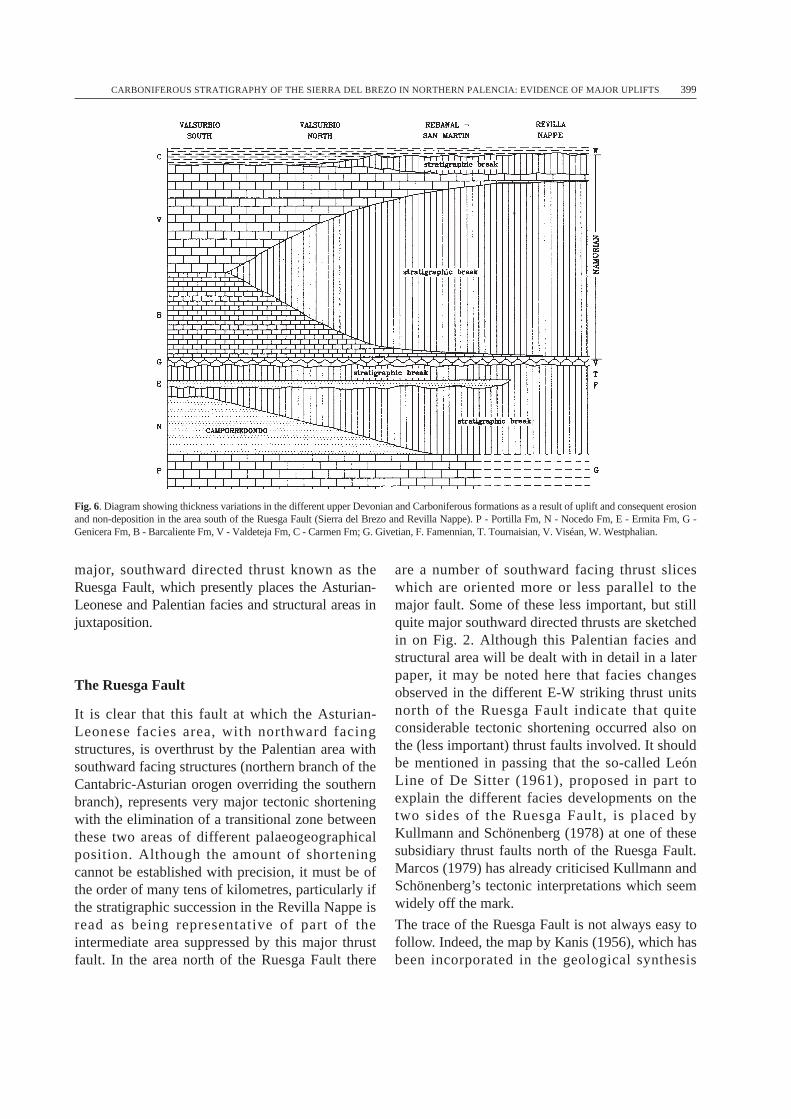
Fig. 6. Diagram showing thickness variations in the different upper Devonian and Carboniferous formations as a result of uplift and consequent erosionand non-deposition in the area south of the Ruesga Fault (Sierra del Brezo and Revilla Nappe). P - Portilla Fm, N - Nocedo Fm, E - Ermita Fm, G -Genicera Fm, B - Barcaliente Fm, V - Valdeteja Fm, C - Carmen Fm; G. Givetian, F. Famennian, T. Tournaisian, V. Viséan, W. Westphalian.

published by Savage (1977), shows this fault todisappear below the Cretaceous unconformablecover south of Cervera de Pisuerga, whereas in factit runs north of the church in Cervera and continueseastwards up to the point where its trace turnssouth-eastwards to coincide with the Barrio deSanta María Fault, which seems to be a Mesozoic-Tertiary reactivation of the Ruesga fracture zone(Wagner et al., 1984, p. 91-92; for a more extensiveaccount of the later tectonic movements see Espinaet al., 1996). It is the later reactivation of theRuesga Fault that has been interpreted as an obliquereverse fault by Espina et al. (1996). There is nodoubt that the Ruesga Fault line was reactivated inMesozoic and post-Mesozoic times (it probablyplayed its part in the position of the Mesozoic basinmargin since the Triassic and Jurasic strata thin anddisappear near this fault line), but its mainsignificance is as a major thrust fault in thePalaeozoic separating the Asturian-Leonese andPalentian facies and structural areas.
The trace of the Ruesga Fault can be followedwestwards from less than a hundred metres north ofthe Ruesga Dam site to a locality east of Ventanillawhere it appears as a sheared fault zone, severalmetres wide, in which fragments (horses) of severalformations are found, with lithologies apparentlyincluding upper Devonian nodular limestones ofPalentian facies, lower Carboniferous nodularlimestones, and carbonate debris flows withrounded quartzite pebbles which are identifiable aslower Moscovian Perapertú Formation, also of thePalentian facies area. Further westwards, the traceof the Ruesga Fault apparently runs with a linemarked by intrusives and it continues into theclearly faulted contact between shales of thePerapertú Formation, north of the fault, andDevonian strata to the south, at c. 800 m south ofthe village of La Lastra. Its trace continueswestwards following a line of quartz porphyriteintrusions and it apparently delimits the outcrop ofthe Camporredondo Quartzite Formation furtherwestwards to where the Ruesga Fault disappearsbelow the unconformable upper Westphalian D andlower Cantabrian succession of the GuardoCoalfield. There is no apparent continuity with theLeón Fault which is shown as the same fault zonein a number of regional syntheses, and which
Marín’s (1977) structural sketch map also attemptsto justify, but unconvincingly.
The age of the Ruesga Fault follows in part fromthat of the highest deposits implicated, whichbelong to the Carmen Formation, and partly fromthat of the Curavacas Conglomerate Formationwhich overlies with total unconformity the variousthrust slices of the Palentian area whichcommences with the Ruesga Fault. The CarmenFormation is regarded as early Westphalian(Langsettian) in age (Wagner et al., 1984), whilstthe Curavacas Formation belongs to uppermostLangsettian and lower Duckmantian (see Wagnerand Álvarez-Vázquez, 1995). This means that theoriginal and most important movements on theRuesga Fault, placing the Palentian facies andstructural area in juxtaposition with the Asturian-Leonese area of the Sierra del Brezo, took place inLangsettian (early Westphalian) times.
Tectonic structure
The configuration of southward directed thrust unitsnorth of the Ruesga Fault overriding and interferingwith the northward facing units of the Sierra delBrezo structural area south of the fault implies thatthe Palentian and Asturian-Leonesepalaeogeographic areas are basically still in thesame relative position, although the distances wereshortened very considerably. Indeed, thestratigraphic comparison with the Revilla Nappewhich is interpreted as representing an areapalaeogeographically just north of the Rebanal-SanMartín-Ventanilla region in the northern part of theSierra del Brezo, suggests that the Ruesga Faultacted as a major overthrust which suppressed a widezone transitional between the Palentian area to thenorth and the Asturian-Leonese area to the south.Carboniferous facies observed in the first thrust slicenorth of the Ruesga Fault and comparison withdifferent facies developments in strata of the sameViséan and early Namurian ages in successive thrustslices further north provide confirmation of large-scale tectonic shortening as a result of the southwarddirected thrusting. (The detail of the facies changesobserved in this Palentian area north of the RuesgaFault will be given in a forthcoming paper, which isin preparation.)
400 R. H. WAGNER AND C. F. WINKLER

This information is contrary to the idea publishedby Frankenfeld (1984), who proposed that thePalentian area would originally have lain to thesouth of the Sierra del Brezo and to have beenmoved across the Sierra del Brezo northwards.According to this interpretation it would havebeen part of the West Asturian - Leonese Zone ofLotze (1945), which is now covered byCretaceous and Tertiary sediments of theCastilian and Leonese Meseta. Frankenfeldadduced stratigraphic information which can alsobe interpreted differently. He further postulatednorthward movement of a large Montó-Arrauznappe structure which in fact consists of twogeographically separate structures, viz. theGildar-Montó klippe in northeastern León andthe Polentinos nappe in northern Palencia.However, the folds and thrusts within thePolentinos nappe verge southwards and notnorthwards (compare Ambrose, 1972), and oneof the present writers (RHW) has recentlyascertained the position of the head of this nappe,with Carazo quartzite of the Silurian-Devoniantransition stuck into lower Westphalian shalesand turbidites (Carmen Formation), alsoindicating a southward movement. Despite all thefactual data to the contrary, Frankenfeld’s ideashave found support among structural geologists(e.g. Rodriguez-Fernández and Heredia, 1988;Pérez-Estaún and Bastida, 1990). Detailedfieldwork is obviously desirable before tectonictheory is propounded.
Conclusions
1. The Sierra del Brezo in northern Palenciabelongs to the Asturian-Leonese facies andstructural area, and constitutes the easterncontinuation of Palaeozoic structures and faciesdevelopment in northern León. Recognition anduse of the same formations is recommended.
2. The marked northward thinning of Namuriancarbonate units identified as Barcaliente and
Valdeteja formations is accompanied by evidenceof erosional contacts showing pre-Valdeteja andpre-Carmen Fm uplifts of mid-Namurian and latestNamurian/earliest Westphalian ages, respectively.Stratigraphic dating still needs to be improved.
3. These two stratigraphic breaks of differentNamurian ages developed in the same northwarddirection as the late Famennian break underlyingthe Ermita Formation, and they show the presenceof an area of repeated uplifts in the northern part ofthe Sierra del Brezo.
4. Stratigraphic breaks at the same level occur inthe Revilla Nappe, about 30 km to the east, wherethey are accompanied by unconformities and evenmore elimination of strata. The succession in theRevilla Nappe suggest its original position tocorrespond to a more central part of the area ofrepeated uplifts.
5. The Ruesga Fault at which the northern branchof the Cantabric-Asturian tectonic orogen overridesthe southern branch, places the Palentian facies andstructural area in juxtaposition with the Asturian-Leonese area. It suppresses a wide strip oftransitional facies, which includes a substantial partof the area of repeated uplifts mentioned above.
6. The Asturian-Leonese and Palentian facies andstructural areas remained in the same relativepalaeogeographic position, although a wide strip oftransitional terrain was suppressed by southwardthrusting on the Ruesga Fault. Frankenfeld’s(1984) theory that the Palentian area would havemoved in from the south across the Asturian-Leonese area in the Sierra del Brezo runs counterto the factual data.
Acknowledgements
Conodont samples taken by the present writers were processed by DrsM. van den Boogaard, A.C. Higgins, and T. Nemirovskaya (work still inprogress). L. Fernández-García is acknowledged for the goniatite findnear Villafría, and C.H.T. Gentis for the identification. Two anonymousreferees have made critical comments which have acted as a spur toprovide a more detailed explanation of data and their proper use in ageologically complicated region.
CARBONIFEROUS STRATIGRAPHY OF THE SIERRA DEL BREZO IN NORTHERN PALENCIA: EVIDENCE OF MAJOR UPLIFTS 401
References
Adrichem Boogaert, A. C. van (1967): Devonian and Lower Carboniferousconodonts of the Cantabrian Mountains (Spain) and their stratigraphicapplication. Leidse Geologische Mededelingen, 39: 129-192.
Ambrose, T. (1972): The stratigraphy and structure of the pre-Carboniferousrocks North-West of Cervera de Pisuerga, Cantabrian Mountains, Spain.Ph. D. Thesis University of Sheffield, 208 p. (unpublished).
Brouwer, A. (1964a): Deux faciès dans le Dévonien des MontagnesCantabriques. Breviora Geológica Astúrica, VI: 49-51.
Brouwer, A. (1964b): Deux faciès dans le Dévonien des MontagnesCantabriques méridionales. Breviora Geológica Astúrica, VIII (1-4): 3-10.
Brouwer, A. and Ginkel, A. C. van (1964): La succession carbonifère dans lapartie méridionale des Montagnes Cantabriques (Espagne du Nord-Ouest).Compte Rendu V Congrès International Stratigraphie et Géologie duCarbonifère, Paris 1963, I: 307-319.
Comte, P. (1938): La transgression du Famennien supérieur dans la CordillèreCantabrique. Comptes rendus Académie des Sciences, Paris, 206: 1741-1743.
Comte, P. (1959): Recherches sur les terrains anciens de la CordillèreCantabrique. Memorias Instituto Geológico Minero de España, 60: 1-440(published 1963).
Espina, R. G., Alonso, J. L. and Pulgar, J. A. (1996): Growth andpropagation of buckle folds determined from syntectonic sediments (theUbierna Fold Belt, Cantabrian Mountains, N. Spain). Journal of StructuralGeology, 18 (4): 431-441.
Frankenfeld, H. (1984): Deckenbewegungen im Namur des östlichenKantabrischen Gebirges und die damit verbundenen Vorstellungen über diePaläogeographie der Namur- und Prä-Namur-Schichten. Zeitschriftdeutschen geologischen Gesellschaft, 135: 223-241.
García-Alcalde, J. L., Montesinos, J. R., Truyóls Massoni, M., GarcíaLópez, S., Arbizu, A. and Soto, F. (1988): El Silúrico y el Devónico delDominio Palentino (NO de España). Revista Sociedad Geológica deEspaña, 1 (1-2): 7-13.
Ginkel, A. C. van (1965): Spanish Carboniferous fusulinids and theirsignificance for correlation purposes. Leidse Geologische Mededelingen,34: 171-225.
Gordon, M. (1964): Carboniferous Cephalopods of Arkansas. U.S. GeologicalSurvey Professional Paper, 460: 322 p.
Higgins, A. C. and Wagner-Gentis, C. H. T. (1982): Conodonts, goniatitesand biostratigraphy of the earlier Carboniferous from the CantabrianMountains, Spain. Palaeontology, 25 (2): 313-350.
Kanis, J. (1956): Geology of the eastern zone of the Sierra del Brezo (Palencia -Spain). Leidse Geologische Mededelingen, 21 (2): 377-445 (Spanishtranslation: Investigaciones geológicas en la zona oriental de la Sierra delBrezo. Estudios Geológicos, XVI (1960): 109-156).
Koopmans, B. N. (1962): The sedimentary and structural history of theValsurvio Dome, Cantabrian Mountains, Spain. Leidse GeologischeMededelingen, 26: 121-232.
Kullmann, J. and Schönenberg, R. (1978): Facies differentiation caused bywrench deformation along a deep-seated fault system (León Line,Cantabrian Mountains, North Spain). Tectonophysics, 48: 15-22.
Lobato, L. (1977): Geología de los valles altos de los ríos Esla, Yuso, Carrióny Deva (NE de León, NO de Palencia, SO de Santander). Instituto FrayBernardino de Sahagún, Diputación Provincial de León: 192 p.
Lobato, L., Velando, F., Heredia, N., Matas, J. and RodríguezFernández, L. R. (1985): Mapa Geológico de España 1:50.000, Hoja n.º106 (16-7) (Camporredondo de Alba). Memoria explicativa por L. R.Rodríguez Fernández, N. Heredia y F. Velando, 98 p. (1985). InstitutoGeológico y Minero de España, Madrid.
Lotze, F. (1945): Zur Gliederung der Varisziden der Iberischen Meseta.Geotektonische Forschungen, 6: 1-12 (Spanish translation by J.M. Ríos,1950: Observaciones respecto a la división de los varíscides de la MesetaIbérica. Publicaciones Extranjeras sobre Geología de España, V: 149-166).
Marcos, A. (1968): Nota sobre el significado de la “León Line”. BrevioraGeológica Astúrica, XII (3): 1-5.
Marcos, A. (1979): Facies differentiation caused by wrench deformation alonga deep-seated fault system (León Line, Cantabrian Mountains, NorthSpain). Discussion. Tectonophysics, 60: 303-309.
Marín, J. A. (1997). Estructura del domo de Valsurbio y borde suroriental dela región del Pisuerga-Carrión (Zona Cantábrica, NO de España). Tesisdoctoral, Universidad de Oviedo (unpublished).
Marín, J. A., Pulgar, J. A. and Alonso, J. L. (1995): La deformación alpinaen el Domo de Valsurvio (Zona Cantábrica, NO de España). RevistaSociedad Geológica de España, 8 (1-2): 111-116.
Marín, J. A., Villa, E, García-López, S. and Menéndez, J. R. (1996):Estratigrafía y metamorfismo del Carbonífero de la Zona de San Martín-Ventanilla (Norte de Palencia, Cordillera Cantábrica). Revista SociedadGeológica de España, 9 (3-4): 241-251.
Marín, J. A., Villa, E., García-López, S. and Menéndez, J. R. (1997):Réplica. Revista Sociedad Geológica de España, 10 (1-2): 200-202.
Pérez-Estaún, A. and Bastida, F. (1990): Structure. Cantabrian Zone. In: Pre-Mesozoic geology of Iberia (R.D. Dallmeyer and E. Martínez García, Eds.),Springer Verlag, Berlin: 55-69.
Pérez-Estaún, A., Bastida, F., Alonso, J. L., Marquínez, J., Aller, J.,Alvarez-Marrón, J., Marcos, A. and Pulgar, J. A. (1988): A thin-skinned tectonics model for an arcuate fold and thrust belt: the CantabrianZone (Variscan Ibero-Armorican Arc). Tectonics, 7 (3): 517-537.
Pérez-Estaún, A., Pulgar, J. A., Banda, E., Alvarez-Marrón, J. andESCIN Research Group (1994): Crustal structure of the externalvariscides in northwest Spain from deep seismic reflection profiling.Tectonophysics, 232: 91-118.
Pulgar, J. A. (1973): La zona de escamas de San Martín-Ventanilla y suposible relación con el domo de Valsurvio. Breviora Geológica Astúrica,XVII (4): 55-64.
Pulgar, J., Pérez-Estaún, A., Gallart, J., Alvarez-Marrón, J.,Gallastegui, J., Alonso, J. L. and ESCIN group (1995): The ESCIN-2deep seismic reflection profile: a traverse across the Cantabrian Mountainsadjacent Duero Basin. Revista Sociedad Geológica de España, 8 (4): 75-86.
Quiring, H. (1939): Die ostasturischen Steinkohlenbecken. Archiv fürLagerstättenforschung, 69: 1-66 (Spanish translation by A. de Alvarado,1943: Cuencas hulleras al Este de Asturias. Boletín Instituto GeológicoMinero de España, LVI: 453-538).
Radig, F. (1962): Zur stratigraphie des Devons in Asturien (Nord-Spanien).Geologische Rundschau, 51: 249-267.
Raven, J. G. M. (1983): Conodont biostratigraphy and depositional history ofthe Middle Devonian to Lower Carboniferous in the Cantabrian Zone(Cantabrian Mountains, Spain). Leidse Geologische Mededelingen, 52:265-339.
Reuther, C. D. (1977): Das Namur im südlichen Kantabrischen Gebirge(Nordspanien); Krustenbewegungen und Faziesdifferenzierung imÜbergang Geosynklinale - Orogen. Clausthaler GeologischeAbhandlungen, 28: 122 p. (Doctoral Thesis).
Reuther, C. D. (1982): The Lower Carboniferous facies levelling and the firstUpper Carboniferous tectonic events in the Cantabrian Mountains and thePyrenees (Spain) - A comparison. Neues Jahrbuch für Geologie undPaläontologie, Abhandlungen 163 (2): 244-250.
Ries, A. C., Richardson, A. and Shackleton, R. M. (1980): Rotation of theIberian arc: Palaeomagnetic results from North Spain. Earth and PlanetaryScience Letters, 70: 301-310.
Rodríguez Fernández, L. R. and Heredia, N. (1988): Evolucióntectonosedimentaria de una cuenca de antepaís ligada a una cadenaarqueada: el ejemplo de la unidad del Pisuerga - Carrión (Zona Cantábrica,N.O. de España). III Congreso Geológico de España. Granada. Simposiosobre cinturones orogénicos: 65-74. Sociedad Geológica de España.
Savage, J. F. (1977): Sheet Carrión. In: J. Savage and D. Boschma, 1980.Geological maps of the southern Cantabrian Mountains (Spain). LeidseGeologische Mededelingen, 50 (2): 75-114.
Sitter, L. U. de (1961): The structure of the southern slope of the CantabrianMountains: explanation of a geological map with sections (scale1:100.000). Leidse Geologische Mededelingen, 26: 255-264.
Wagner, R. H. (1971): Carboniferous nappe structures in north-easternPalencia (Spain). Trabajos de Geología, Universidad de Oviedo, 4 (2):431-459.
Wagner, R. H and Álvarez-Vázquez, C. (1995): Upper Namurian/lowerWestphalian of La Camocha, Asturias: Review of floral and faunal data.Coloquios de Paleontología, 47:151-176.
Wagner, R. H., Carballeira, J., Ambrose, T. and López Rico, J. (1984):Mapa Geológico de España 1:50.000, Hoja n.º 107 (17-7) (Barruelo deSantullán). Memoria explicativa por R. H. Wagner, J. Carballeira, T.Ambrose y E. Martínez García, 113 p. (1984). Instituto Geológico y Minerode España, Madrid.
Wagner, R. H. and Fernández-García, L. (1983): Upper Westphalian D andCantabrian strata in the Guardo Coalfield: Tectonics, Sedimentation,Stratigraphy. In: R. H. Wagner, L. Fernández-García and R. M. C. Eagar:Geology and Palaeontology of the Guardo Coalfield (NE León - NWPalencia), Cantabrian Mts: 11-55. Instituto Geológico Minero de España,Madrid (Serie Informes).
402 R. H. WAGNER AND C. F. WINKLER

Wagner, R. H. and Fernández-García, L .G. (1984): Late Westphalian D andCantabrian Strata in the Guardo Coalfield (NW Spain): Tectonics,Sedimentation, Stratigraphy. Compte Rendu 9e Congrès InternationalStratigraphie et Géologie du Carbonifère, Washington and Champaign-Urbana, 3: 345-366.
Wagner, R. H., Martínez García, E., Winkler Prins, C. F. and Lobato, L.(1983): Carboniferous stratigraphy of the Cantabrian Mountains. XInternational Congress Carboniferous Stratigraphy and Geology, Madrid,1983, Guidebook Field Trip A: 212 p.
Wagner, R. H. and Wagner-Gentis, C. H. T. (1963): Summary of thestratigraphy of Upper Palaeozoic rocks in NE. Palencia, Spain.Proceedings Koninklijke Nederlandse Akademie van Wetenschappen, B, 66(3): 149-163.
Wagner, R. H. and Winkler Prins , C. F. (1997): Estratigrafía ymetamorfismo del Carbonífero de la Zona de San Martín-Ventanilla (Nortede Palencia, Cordillera Cantábrica): Discusión. Revista Sociedad Geológica
de España, 10 (1-2): 197-199.
Wagner, R. H., Winkler Prins, C. F. and Riding , R. E. (1971):Lithostratigraphic units of the lower part of the Carboniferous in northernLeón, Spain (with a Note on some goniatite faunas by C. H. T. Wagner-Gentis). Trabajos de Geología, Universidad de Oviedo, 4 (2): 603-663.
Wagner-Gentis, C. H. T. (1980): Goniatites from the Viséan-Namurianjunction beds in Palencia, NW Spain. Scripta Geologica, 55: 1-43.
CARBONIFEROUS STRATIGRAPHY OF THE SIERRA DEL BREZO IN NORTHERN PALENCIA: EVIDENCE OF MAJOR UPLIFTS 403