carsten lemmen and aurangzeb khan - arxiv · climates landscapes civilizations, vol.??, xxxx,...
TRANSCRIPT
CLIMATES LANDSCAPES CIVILIZATIONS, VOL. ???, XXXX, DOI:10.1029/,
A simulation of the Neolithic transition in the Indus valley
Carsten Lemmen and Aurangzeb Khan
The Indus Valley Civilization (IVC) was one of the firstgreat civilizations in prehistory. This bronze age civilizationflourished from the end of the fourth millennium BC. It dis-integrated during the second millennium BC; despite muchresearch effort, this decline is not well understood. Less re-search has been devoted to the emergence of the IVC, whichshows continuous cultural precursors since at least the sev-enth millennium BC. To understand the decline, we believeit is necessary to investigate the rise of the IVC, i.e., the es-tablishment of agriculture and livestock, dense populationsand technological developments 7000–3000 BC. Althoughmuch archaeological information is available, our capabil-ity to investigate the system is hindered by poorly resolvedchronology, and by a lack of field work in the intermedi-ate areas between the Indus valley and Mesopotamia. Wethus employ a complementary numerical simulation to de-velop a consistent picture of technology, agropastoralism andpopulation developments in the IVC domain. Results fromthis Global Land Use and technological Evolution Simulatorshow that there is (1) fair agreement between the simulatedtiming of the agricultural transition and radiocarbon datesfrom early agricultural sites, but the transition is simulatedfirst in India then Pakistan; (2) an independent agropas-toralism developing on the Indian subcontinent; and (3) apositive relationship between archeological artifact richnessand simulated population density which remains to be quan-tified.
1. Introduction
The Indus Valley Civilization (IVC), often termed Harap-pan civilization after its major type site, flourished along thebanks of the river Indus and its tributaries, including the ad-jacent coastal areas, between the fourth and second millen-nium BC. The IVC is characterized by urban centers, bronzetechnology and seals, trade networks with Mesopotamia andArabia, and an as yet undeciphered writing system [Shaffer ,1992; Possehl , 1998; Kenoyer , 2008]. Much research hasbeen devoted to the disintegration of the IVC during thesecond millennium BC, and much less to the emergence ofthis great civilization which shows continuous cultural pre-cursors at least since the seventh millennium BC, such thatsome authors prefer to speak of the Indus valley culturaltradition [e.g., Kenoyer , 2006].
The Indus valley is one of the two great river basins onthe Indian subcontinent, separated from the Ganges val-ley to the east by the Aravalli mountain range and theThar desert (Figure 1b). The region has been occupied byanatomically modern humans for at least 34,000, but pos-sibly >80,000 years [Petraglia et al., 2010]. The late Pa-leolithic and the Mesolithic are visible in stone and blade
Copyright 2012 by the American Geophysical Union.0094-8276/12/$5.00
industries; microlith blades indicate composite tools, differ-entiated occupation levels and a broad-spectrum diet of for-aging people from 26,000 years before present (a BP) untilat least the second millennium BC, well into the Bronze age[Petraglia et al., 2009].
Neolithic subsistence is based on a combination of bar-ley and wheat dominated agriculture and herding of sheep,goats, and cattle. Domesticates are of mixed origin: barleyand wheat have no local wild progenitor, but zebu cattlebears a clear signature of local domestication [Chen et al.,2010; Fuller , 2011a]. The beginning of the Neolithic on theIndian subcontinent is regionally diverse and ranges from6500 BC in Baluchistan [Jarrige, 1995] to 3000 BC or lateron the central Indian plateau and in the Himalaya mountainrange [Samuel , 2000; Boivin et al., 2008]. Our focus here ison the period which spans from the Neolithic to the begin-ning of the Bronze age of the IVC (7000–3200 BC), i.e., onthe early food production and regionalization eras, or theMehrgarh phase and parts of the early Harappan phase ac-cording to the different chronologies [Sharma et al., 1980;Fuller , 2006; Kenoyer , 2008].
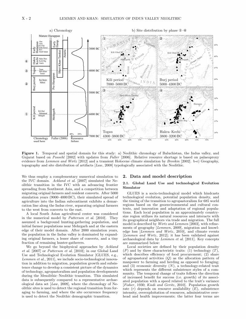
Possehl [2002] separated these phases and eras of thepre-Harappan Neolithic into two stages (Figure 1a): EarlyNeolithic and Developed Neolithic. The Early Neolithicis divided in the Kili Ghul Mohammad (KGM) and theBurj Basket-Marked (BBM) periods. Sites attributed tothese periods are found in the western borderlands of thegreater Indus region and cluster in the hills and piedmont ofBaluchistan (Figure 1 b1–b2). During the BBM, soft potteryand handmade pottery are introduced. Deposits of trashwith burnt pebbles, ash, animal bones, bone tools, hammerstones, polishers colored with red ochre, and a large collec-tion of blades, cores, and flint debris have been discovered,and point to leather making, basket making, or weaving.Domesticated wheat, barley and cotton were used, pulsesmay have been present; the use of copper is visible in theform of arrowheads and beads [Moulherat et al., 2002; Fuller ,2011a].
The Developed Neolithic is characterized by improvedpottery, developed agropastoral communities, growth, con-tinuity, and geographical expansion. During its first period(here defined as both Togau and Sheri Khan Tarakai, SKT,Figure 1 b3), the settlement patterns show growth of villagelife; technological innovations include the use of gold, themanufacture of compartmented seals, glazed steatite, andbeads. An eastward expansion is visible in sites emerg-ing along the ancient Ghaggar Hakra river. The secondperiod of the Developed Neolithic (Figure 1 b4) comprisesseveral cultural complexes. In the Kechi Beg complex inBaluchistan wheat replaces barley; an irrigation canal nearMehrgarh may date to this period [Kenoyer , 2008]. On thePunjab plain, a change in the assemblage of pottery typescharacterizes the Hakra Ware complex: Microlithic tools areabundant, and sites represented by a light scatter of potterywithout a buildup of a midden point to seasonal occupations[Possehl , 2002]. At the same time, the Anarta complex ap-pears in Gujarat with distinct pottery styles.
Our capability to investigate the system more closely andconsistently in the regional context is hindered by the poorlyresolved chronology, and by a lack of field work in the inter-mediate areas between the Indus valley and Mesopotamia.
1
arX
iv:1
110.
1091
v3 [
q-bi
o.PE
] 7
May
201
2
X - 2 LEMMEN AND KHAN: SIMULATION OF INDUS VALLEY NEOLITHIC
a) Chronology b) Site distribution by phase ¬–¯
7000 BC
6000 BC
5000 BC
4000 BC
3000 BC
Kil
i per
iod
Bur
j per
iod
Toga
uH
akra
Kec
hiE
arly
Har
appa
n AharAmriKot DijiSothi-SiswalRaviDamb Sadaat
Pre
-Har
appa
nE
arly
Har
ap.
She
ri-K
han-
Tara
kai
Hakra WareKechi BegAnarta
TogauSheri-Khan- Tarakai
Burj Basket Marked
Kili Ghul MohammadMehrgarh
Ana
rta
Chronologyused here
Fuller (2006) Ressourcefailure
Mature Harappan
40% 20%
Meh
rgar
h
¬
®
¯
63oE 66oE 69oE 72oE 75oE
24oN
27oN
30oN
33oN
PAKISTAN
A F G H A N I ST A N
I N D I A
IR
AN
Punjab
Sindh
Gujarat
Baluchistan
Kashmir
Rajasthan
Thar
desert
Aravallirange
Makran coast
Mehrgarh
Kili Ghul M.
¬
Kili period7000–5000BC
63oE 66oE 69oE 72oE 75oE
24oN
27oN
30oN
33oN
Indusval ley
Ganges
Thar
desert
Aravallirange
Mehrgarh
Kili Ghul M.
Ghaggar H
akra
Burj period5000–4300BC
63oE 66oE 69oE 72oE 75oE
24oN
27oN
30oN
33oN
PAKISTAN
A F G H A N I ST A N
I N D I A
IR
AN
Punjab
Sindh
Gujarat
Baluchistan
Kashmir
Rajasthan
Thar
desert
Aravallirange
Makran coast
Mehrgarh
Kili Ghul M.
63oE 66oE 69oE 72oE 75oE
24oN
27oN
30oN
33oN
Togau
Sheri Khan Tarakai
®
Togau4300–3800BC
63oE 66oE 69oE 72oE 75oE
24oN
27oN
30oN
33oN
Hakraware
Anarta
Harappa
Kechi Beg
¯
Hakra–Kechi3800–3200BC
63oE 66oE 69oE 72oE 75oE
24oN
27oN
30oN
33oN
PAKISTAN
A F G H A N I ST A N
I N D I A
IR
AN
Punjab
Sindh
Gujarat
Baluchistan
Kashmir
Rajasthan
Thar
desert
Aravallirange
Makran coast
Mehrgarh
Kili Ghul M.
Figure 1. Temporal and spatial domain for this study: a) Neolithic chronology of Baluchistan, the Indus valley, andGujarat based on Possehl [2002] with updates from Fuller [2006]. Relative resource shortage is based on palaeoproxyevidence from Lemmen and Wirtz [2012] and a transient Holocene climate simulation by Brovkin [2002]. b-e) Geography,topography and site distribution of artifacts [Law , 2008] typologically associated with the Neolithic.
We thus employ a complementary numerical simulation tothe IVC domain. Ackland et al. [2007] simulated the Ne-olithic transition in the IVC with an advancing frontierspreading from Southwest Asia, and a competition betweenmigrating original farmers and resident converts. After 5000simulation years (9000–4000 BC), their simulated spread ofagriculture into the Indian subcontinent exhibits a demar-cation line along the Indus river, separating original farmersto the west from converts to the east.
A local South Asian agricultural center was consideredin the numerical model by Patterson et al. [2010]. Theyassumed a background hunting-gathering population, andinitial farmer populations near Mehrgarh and at the easternedge of their model domain. After 2000 simulation years,the population in the Indus valley is dominated by expand-ing original farmers, a lesser share of converts, and a tinyfraction of remaining hunter-gatherers.
We go beyond the biophysical approaches by Acklandet al. [2007] or Patterson et al. [2010]; in our Global LandUse and Technological Evolution Simulator [GLUES, e.g.,Lemmen et al., 2011], we include socio-technological innova-tion in addition to migration, population growth and subsis-tence change to develop a consistent picture of the dynamicsof technology, agropastoralism and population developmentsduring the Mesolithic–Neolithic transition. This simulateddata is subsequently compared to a representative archae-ological data set [Law , 2008], where the chronology of Ne-olithic sites is used to detect the regional transition from for-aging to farming, and where the site occurrence frequencyis used to detect the Neolithic demographic transition.
2. Data and model description
2.1. Global Land Use and technological EvolutionSimulator
GLUES is a socio-technological model which hindcaststechnological evolution, potential population density, andthe timing of the transition to agropastoralism for 685 worldregions based on the geoenvironmental and cultural con-texts, and innovation and adaptation of regional popula-tions. Each local population in an approximately country-size region utilizes its natural resources and interacts withits geographical neighbors via trade and migration. The fullmodel is described by Wirtz and Lemmen [2003], with refine-ments of geography [Lemmen, 2009], migration and knowl-edge loss [Lemmen and Wirtz , 2010], and climate events[Lemmen and Wirtz , 2012]; it has been validated againstarchaeological data by Lemmen et al. [2011]. Key conceptsare summarized below:
Local societies are defined by their population density(P ) and by three characteristic traits: (1) technology (T ),which describes efficiency of food procurement; (2) shareof agropastoral activities (Q) as the allocation pattern ofmanpower to farming and herding as opposed to foraging;and (3) economic diversity (N), a technology-related traitwhich represents the different subsistence styles of a com-munity. The temporal change of traits follows the directionof increased benefit for success (i.e. growth) of its associ-ated population with a speed related to the trait’s variance[Fisher , 1930; Kisdi and Geritz , 2010]. Population growthrate (r) depends on resource availability (E), subsistenceintensity, overexploitation of resources, administrative over-head and health improvements; the latter four terms are

LEMMEN AND KHAN: SIMULATION OF INDUS VALLEY NEOLITHIC X - 3
functions of P, T,N , and Q, while the resource availabil-ity E is provided externally. E is estimated from the netprimary productivity, which is in turn based on Climber-2[Claussen et al., 1999] transient temperature and precipi-tation anomalies from the IIASA climatological data base[International Institute for Applied Systems Analysis, Lee-mans and Cramer , 1991].
Abrupt climate deteriorations modulate E; they are in-corporated by using the extreme event anomalies foundin 124 globally distributed palaeoclimate proxies collectedand analyzed by Wirtz et al. [2010]; the estimation of re-source failure from proxy climate is described by Lemmenand Wirtz [2012]. Figure 1a shows the average relative de-cline of E in the Indus valley region; these anomalies arederived from regional abrupt changes found in oxygen iso-tope anomalies from Kyrgyzstan [Ricketts et al., 2001], Ti-bet [Fontes et al., 1996], the Arabian Sea [Doose-Rolinskiet al., 2001; Gupta et al., 2003], and Oman [Fleitmann et al.,2007].
We set up the eight global model parameters and initialvalues such that the simulation is able to hindcast an ac-curate timing and location of the early farming centers inSouthwest Asia, northern China, and Mesoamerica [Smith,1998], and a reasonable global pattern of the subsequent Ne-olithic transition. The simulation is started at 9500 sim BC(simulation years BC; equivalent to calendar years BC,but emphasizes the artificial model time scale, Lemmenet al. 2011). All of the 685 biogeographically defined re-gions, including 32 around the Indus valley, are initiallyset with farming activity at 4%, 1/4 established agropas-toral economies and unit technology; this setup represents alow density Mesolithic population relying on a broad spec-trum foraging lifestyle with low unintentional farming activ-ity. The regional simulated transition to agropastoralism isrecorded when Q exceeds 0.5.
2.2. Artifact database
We used the Indus Google Earth Gazetteer (version Au-gust 2008) compiled by Law [2008] for the geolocation ofartifacts relating to the Indus valley. From this databaseof 21687 metal and stone artifacts, we use here the culturalattribution and location of those 2028 artifacts and 368 sitesthat are in the spatial and temporal domain of our study.For KGM, 18 sites contribute 90 artifacts to the data base;for BBM, there are 159 artifacts at 32 sites. We combinedthe sites attributed to the Togau period with sites from theSKT (both with starting date 4300 BC, Fuller 2006) andobtain 317 artifacts from 65 sites.
The subsequent period is represented by the Hakra Ware,Kechi Beg, and Anarta complexes. Combined, there are1250 artifacts (396, 670, and 184, respectively) from 253 sites(99, 112, and 42, respectively). While the main chronologyis based on Possehl [2002], sites from the Anarta complexwere included in this period based on Fuller [2006]. To ourknowledge, this gazetteer is the most representative dataset of lithic and metal artifacts of the Indus valley tradition.It has been used to investigate the trade and distributionnetworks of the IVC by its author [Law , 2011].
In archaeological or palaeoenvironmental archives, the de-crease of the number of dates further back in time thatis caused by gradual destruction of the archive by post-depositional processes results in a taphonomic bias [Surov-ell et al., 2009]. We applied to the artifact density dataa bias correction derived from the comparison of volcaniceruption layers in the GISP2 (Greenland, no taphonomicbias) ice core with radiocarbon dated ash deposits; thecorrection factor c depends on time t (in a BP): c(t) =5.73·106(2175.4+t)−1.39 [Surovell et al., 2009]. This methodwas successfully validated with Canadian coin mintage datacompared to a coin collection and applied to North Ameri-can radiocarbon dates by Peros et al. [2010].
3. Results and Discussion
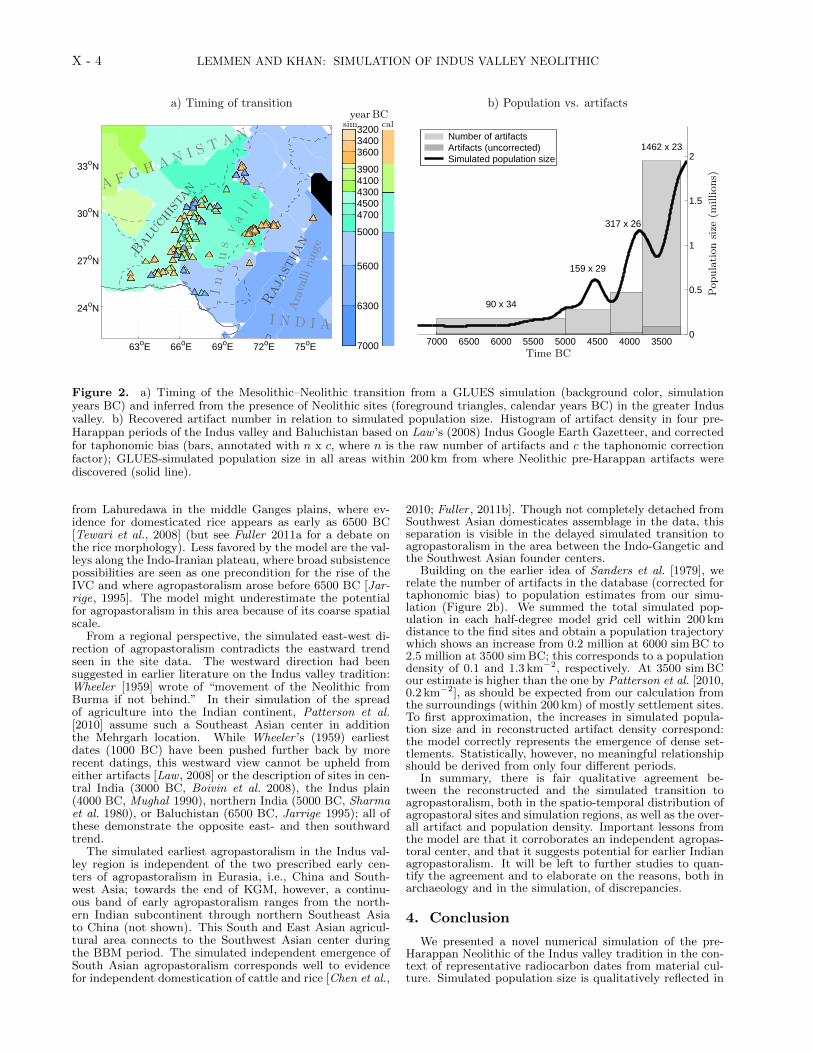
The simulated transition to predominantly agropastoralism-based subsistence occurs in the spatial domain of theIndus valley and surrounding areas between 6300 and3800 sim BC (Figure 2a). There is a general east-west trendin the simulated transition dates. Contemporary with theKGM, the earliest transitions are simulated in India (be-fore 5600 sim BC), including Rajasthan, Gujarat, and theGanges valley, and early transitions (before 5000 sim BC)in southern Sindh and northern Pakistan, including parts ofthe Punjab and Kashmir. During this first period, 15 outof 32 simulation regions undergo the transition to agropas-toralism. Most of the remaining regions (Pakistan, easternAfghanistan, eastern Iran and Makran coast) transition inthe BBM period before 4300 sim BC. Of these, agropastoral-ism is simulated first in the Punjab and northern Baluchis-tan (before 4700 sim BC), then in northern Sindh (before4500 sim BC). The simulated transition occurs latest, dur-ing the Togau period, in the eastern model domain, fromcentral Afghanistan to the Pakistan-Afghanistan-Iran bor-der triangle (4300–3800 sim BC).
A detailed and quantitative comparison is limited fore-most by the inherent timing uncertainties in the typolog-ically dated artifacts. This is closely related to the sec-ondary comparison difficulty, which is created by the lack oftemporal continuity of samples from the Mesolithic to theNeolithic. While we have shown how these issues can be ad-dressed in the context of plenty and precise dates for Europe[Lemmen et al., 2011], the comparison with dates from theIndian subcontinent can only be qualitative at this moment(see also Patterson et al. 2010, who make a qualitative com-parison not with single sites, but with approximate timingcontours).
In addition, the coexistence of Mesolithic and Neolithicsubsistence in the archaeological record complicates thecomparison between model and data, because the degree ofboth subsistence styles cannot be quantified with the currentdata. This coexistence is evident in the long-term contin-ued use of (Mesolithic) microlithic tools, transhumance lifestyle, i.e., the seasonal back-and-forth movement of herderswith their livestock, and the continuation of foraging prac-tice well into the Neolithic [Mughal , 1990; Fuller , 2011a], itis not resolved in the model, where agropastoral life style isusually dominant within less than 500 years after its emer-gence [Lemmen and Wirtz , 2012].
The model simulates first agropastoralism in northernBaluchistan and southern Sindh in the KGM period consis-tent with earliest sites in these areas. For the major part ofBaluchistan, including the Mehrgarh site, the model placesthe transition in the BBM period, which is later than theearliest site dates, but agrees with dates from many otherlocations in Baluchistan. The most obvious mismatch is theearly simulated (KGM and BBM) transition along the In-dus, the Ghaggar-Hakra and Punjab rivers, where site datesare absent until the Kechi Beg and Hakra periods.
While evidence for early archaeological sites may havebeen lost in the geomorphologically dynamic Indus riverfloodplain, the lack of early sites in Rajasthan is striking,considering that the model sees a biogeographically favor-able environment and cultural setting for an early Neolithic:one should ask whether an agricultural center on the Indo-Gangetic divide is undetected so far. First evidence fornorthern Indian agriculture could come from further east,
X - 4 LEMMEN AND KHAN: SIMULATION OF INDUS VALLEY NEOLITHIC
a) Timing of transition b) Population vs. artifacts
63oE 66oE 69oE 72oE 75oE
24oN
27oN
30oN
33oN
Indus valley neolithization and site chronology cal BC
7000
6300
5600
5000
47004500430041003900 360034003200
A F G H A N I ST A N
I N D I A
Indusval ley
AravallirangeBaluchistan
Rajasthan
63oE 66oE 69oE 72oE 75oE
24oN
27oN
30oN
33oN
Indus valley neolithization and site chronology cal BC
7000
6300
5600
5000
47004500430041003900 360034003200
yearBCsim cal
7000 6500 6000 5500 5000 4500 4000 35000
0.5
1
1.5
2
90 x 34
159 x 29
317 x 26
1462 x 23
Time (cal/sim BC)
Pop
ulat
ion
size
Number of artifacts Artifacts (uncorrected) Simulated population size
Time BC
Populationsize
(millions)
Figure 2. a) Timing of the Mesolithic–Neolithic transition from a GLUES simulation (background color, simulationyears BC) and inferred from the presence of Neolithic sites (foreground triangles, calendar years BC) in the greater Indusvalley. b) Recovered artifact number in relation to simulated population size. Histogram of artifact density in four pre-Harappan periods of the Indus valley and Baluchistan based on Law ’s (2008) Indus Google Earth Gazetteer, and correctedfor taphonomic bias (bars, annotated with n x c, where n is the raw number of artifacts and c the taphonomic correctionfactor); GLUES-simulated population size in all areas within 200 km from where Neolithic pre-Harappan artifacts werediscovered (solid line).
from Lahuredawa in the middle Ganges plains, where ev-idence for domesticated rice appears as early as 6500 BC[Tewari et al., 2008] (but see Fuller 2011a for a debate onthe rice morphology). Less favored by the model are the val-leys along the Indo-Iranian plateau, where broad subsistencepossibilities are seen as one precondition for the rise of theIVC and where agropastoralism arose before 6500 BC [Jar-rige, 1995]. The model might underestimate the potentialfor agropastoralism in this area because of its coarse spatialscale.
From a regional perspective, the simulated east-west di-rection of agropastoralism contradicts the eastward trendseen in the site data. The westward direction had beensuggested in earlier literature on the Indus valley tradition:Wheeler [1959] wrote of “movement of the Neolithic fromBurma if not behind.” In their simulation of the spreadof agriculture into the Indian continent, Patterson et al.[2010] assume such a Southeast Asian center in additionthe Mehrgarh location. While Wheeler ’s (1959) earliestdates (1000 BC) have been pushed further back by morerecent datings, this westward view cannot be upheld fromeither artifacts [Law , 2008] or the description of sites in cen-tral India (3000 BC, Boivin et al. 2008), the Indus plain(4000 BC, Mughal 1990), northern India (5000 BC, Sharmaet al. 1980), or Baluchistan (6500 BC, Jarrige 1995); all ofthese demonstrate the opposite east- and then southwardtrend.
The simulated earliest agropastoralism in the Indus val-ley region is independent of the two prescribed early cen-ters of agropastoralism in Eurasia, i.e., China and South-west Asia; towards the end of KGM, however, a continu-ous band of early agropastoralism ranges from the north-ern Indian subcontinent through northern Southeast Asiato China (not shown). This South and East Asian agricul-tural area connects to the Southwest Asian center duringthe BBM period. The simulated independent emergence ofSouth Asian agropastoralism corresponds well to evidencefor independent domestication of cattle and rice [Chen et al.,
2010; Fuller , 2011b]. Though not completely detached fromSouthwest Asian domesticates assemblage in the data, thisseparation is visible in the delayed simulated transition toagropastoralism in the area between the Indo-Gangetic andthe Southwest Asian founder centers.
Building on the earlier idea of Sanders et al. [1979], werelate the number of artifacts in the database (corrected fortaphonomic bias) to population estimates from our simu-lation (Figure 2b). We summed the total simulated pop-ulation in each half-degree model grid cell within 200 kmdistance to the find sites and obtain a population trajectorywhich shows an increase from 0.2 million at 6000 sim BC to2.5 million at 3500 sim BC; this corresponds to a populationdensity of 0.1 and 1.3 km−2, respectively. At 3500 sim BCour estimate is higher than the one by Patterson et al. [2010,0.2 km−2], as should be expected from our calculation fromthe surroundings (within 200 km) of mostly settlement sites.To first approximation, the increases in simulated popula-tion size and in reconstructed artifact density correspond:the model correctly represents the emergence of dense set-tlements. Statistically, however, no meaningful relationshipshould be derived from only four different periods.
In summary, there is fair qualitative agreement be-tween the reconstructed and the simulated transition toagropastoralism, both in the spatio-temporal distribution ofagropastoral sites and simulation regions, as well as the over-all artifact and population density. Important lessons fromthe model are that it corroborates an independent agropas-toral center, and that it suggests potential for earlier Indianagropastoralism. It will be left to further studies to quan-tify the agreement and to elaborate on the reasons, both inarchaeology and in the simulation, of discrepancies.
4. Conclusion
We presented a novel numerical simulation of the pre-Harappan Neolithic of the Indus valley tradition in the con-text of representative radiocarbon dates from material cul-ture. Simulated population size is qualitatively reflected in
LEMMEN AND KHAN: SIMULATION OF INDUS VALLEY NEOLITHIC X - 5
artifact frequency in four pre-Harappan periods. Within theuncertainties of the coarse chronology, the model predictsthe spatio-temporal structure of the Neolithic transition ofthis area fairly well. Our simulation points to a possibleearlier Neolithic in northern India than seen in the data,and it corroborates an independent South Asian Neolithic.For quantitative model–data comparisons and clarificationof the connection to Southwest Asia, better chronologic con-trol of the pre-Harappan material is needed as well as moreevidence from the intervening Iranian plateau.
Supplementary material
The simulated data have been permanently archived onand are freely accessible from PANGAEA (Data Publisherfor Earth & Environmental Science, http://www.pangaea.de)as a netCDF dataset with reference “Lemmen, C. and Khan,A. (2012): Simulated transition to agropastoralism in the In-dus valley 7500–3000 BC. Dataset #779706, doi:XXXX”.GLUES is open source software and can be downloaded fromhttp://glues.sourceforge.net.
Acknowledgments. We thank R.W. Williams for publiclyproviding his extensive data set for further analysis; we thankthree anonymous reviewers and the editor for their critical andhelpful comments on earlier versions of this manuscript. C.L. ac-knowledges financial support from the DFG priority programInterdynamik (SPP 1266), A.K. acknowledges financial supportfrom the Higher Education Commission of Pakistan and thePACES program of the Helmholtz Gemeinschaft. This paper ben-efitted greatly from ideas presented and discussed at the AGUChapman Conference on Climates, Past Landscapes, and Civi-lizations, held in Santa Fe, USA, March 2011. Maps were pre-pared with Natural Earth free vector and raster map data avail-able from http://naturalearthdata.com.
References
Ackland, G. J., M. Signitzer, K. Stratford, and M. H. Cohen,Cultural hitchhiking on the wave of advance of beneficial tech-nologies., Proc. Natl. Acad. Sci. U.S.A., 104 (21), 8714–9, doi:10.1073/pnas.0702469104, 2007.
Boivin, N., D. Q. Fuller, R. Korisettar, and M. D. Petraglia, FirstFarmers in south India: the role of internal processes and ex-ternal influences in the emergence and transformation of southIndia’s earliest settled societies, Pragdhara, 18, 179–200, 2008.
Brovkin, V., Carbon cycle, vegetation, and climate dynam-ics in the Holocene: Experiments with the CLIMBER-2 model, Global Biogeochem. Cycles, 16 (4), doi:10.1029/2001GB001662, 2002.
Chen, S., et al., Zebu cattle are an exclusive legacy of theSouth Asia Neolithic, Molec. Biol. Evolut., 27 (1), 1–6, doi:10.1093/molbev/msp213, 2010.
Claussen, M., C. Kubatzki, V. Brovkin, A. Ganopolski, P. Hoelz-mann, and H.-J. Pachur, Simulation of an abrupt change inSaharan vegetation in the mid-Holocene, Geophys. Res. Lett.,26, 2037–2040, 1999.
Doose-Rolinski, H., U. Rogalla, and G. Scheeder, High resolutiontemperature and evaporation changes during the late Holocenein the northeastern Arabian Sea, Paleoceanogr., 16 (4), 358–367, 2001.
Fisher, R. A., The Genetical Theory of Natural Selection, Dover,New York, 1930.
Fleitmann, D., et al., Holocene ITCZ and Indian mon-soon dynamics recorded in stalagmites from Oman andYemen (Socotra), Quatern. Sci. Rev., 26 (1-2), 170–188, doi:10.1016/j.quascirev.2006.04.012, 2007.
Fontes, J.-C., F. Gasse, and E. Gibert, Holocene environmen-tal changes in Lake Bangong basin (Western Tibet). Part 1:Chronology and stable isotopes of carbonates of a Holocenelacustrine core, Palaeogeogr. Palaeoclimatol. Palaeoecol., 120,25–47, 1996.
Fuller, D. Q., Agricultural Origins and Frontiers in South Asia:A Working Synthesis, J. World Prehist., 20 (1), 1–86, doi:10.1007/s10963-006-9006-8, 2006.
Fuller, D. Q., Finding Plant Domestication in the IndianSubcontinent, Curr. Anthropol., 52 (S4), S347–S362, doi:10.1086/658900, 2011a.
Fuller, D. Q., Pathways to Asian Civilizations: Tracing the Ori-gins and Spread of Rice and Rice Cultures, Rice, 4 (3-4), 78–92,doi:10.1007/s12284-011-9078-7, 2011b.
Gupta, A., D. Anderson, and J. Overpeck, Abrupt changes in theAsian southwest monsoon during the Holocene and their linksto the North Atlantic ocean, Nature, 421, 354–356, 2003.
Jarrige, C., Mehrgarh: Field Reports 1974-1985, from NeolithicTimes to the Indus Civilization, Dept. of Culture and Tourism,Govt. of Sindh; French Ministry of Foreign Affairs, 1995.
Kenoyer, J. M., Cultures and Societies of the Indus Tradition,in Historical Roots in the Making of ‘The Aryan’, edited byR. Thapar, 1, pp. 10–19, National Book Trust, New Delhi,2006.
Kenoyer, J. M., The Indus Civilization, in Encyclopedia of Ar-chaeology, edited by D. M. Pearsall, pp. 715–733, AcademicPress, New York, 2008.
Kisdi, E., and S. A. H. Geritz, Adaptive dynamics: a frameworkto model evolution in the ecological theatre, J. Math. Biol.,61 (1), 165–9, doi:10.1007/s00285-009-0300-9, 2010.
Law, R. W., Indus Google Earth Gazetteer,https://mywebspace.wisc.edu/rwlaw/, Presented at theIndus Archaeological Technical Training Workshop, 17–20March 2007, Mahara Sayajirao University, Baroda, India,2008.
Law, R. W., Inter-regional interaction and urbanism in the an-cient Indus valley, Linguistics, Archaeology, and the HumanPast, vol. 11, Research Institute for Humanity and Nature,Kyoto, Japan, 2011.
Leemans, R., and W. P. Cramer, The IIASA database for meanmonthly values of temperature, precipitation and cloudiness ofa global terrestrial grid., Research report, International Insti-tute of Applied Systems Analyses, Laxenburg, 1991.
Lemmen, C., World distribution of land cover changes during Pre-and Protohistoric Times and estimation of induced carbon re-leases, Geomorphol. : relief, processus, environ., (4), 303–312,2009.
Lemmen, C., and K. W. Wirtz, Socio-technological revolutionsand migration waves re-examining early world history with amathematical model, in The Spread of the Neolithic to Cen-tral Europe, RGZM Tagungen, vol. 4, edited by D. Gronenbornand J. Petrasch, pp. 25–38, Romisch-Germanisches Zentralmu-seum, Mainz, Germany, 2010.
Lemmen, C., and K. W. Wirtz, On the sensitivity of the sim-ulated European Neolithic transition to climate extremes, J.Archaeol. Sci., submitted, 2012.
Lemmen, C., D. Gronenborn, and K. W. Wirtz, A simulation ofthe Neolithic transition in Western Eurasia, J. Archaeol. Sci.,38 (12), 3459–3470, doi:10.1016/j.jas.2011.08.008, 2011.
Moulherat, C., M. Tengberg, J.-F. Haquet, and B. Mille, FirstEvidence of Cotton at Neolithic Mehrgarh, Pakistan: Anal-ysis of Mineralized Fibres from a Copper Bead, J. Archaeol.Sci., 29 (12), 1393–1401, 2002.
Mughal, M., The decline of the Indus civilization and the LateHarappan period in the Indus valley, Lahore Museum Bulletin,1990.
Patterson, M. A., G. R. Sarson, H. Sarson, and A. Shukurov,Modelling the Neolithic transition in a heterogeneous en-vironment, J. Archaeol. Sci., 37 (11), 2929–2937, doi:10.1016/j.jas.2010.07.003, 2010.
Peros, M. C., S. E. Munoz, K. Gajewski, and A. E. Viau,Prehistoric demography of North America inferred from ra-diocarbon data, J. Archaeol. Sci., 37 (3), 656–664, doi:10.1016/j.jas.2009.10.029, 2010.
Petraglia, M. D., M. Haslam, D. Q. Fuller, N. Boivin, andC. Clarkson, Out of Africa: new hypotheses and evi-dence for the dispersal of Homo sapiens along the In-dian Ocean rim, Ann. Human Biol., 37 (3), 288–311, doi:10.3109/03014461003639249, 2010.
X - 6 LEMMEN AND KHAN: SIMULATION OF INDUS VALLEY NEOLITHIC
Petraglia, M. D., et al., Population increase and environmentaldeterioration correspond with microlithic innovations in SouthAsia ca. 35,000 years ago, South Asia, pp. 1–6, 2009.
Possehl, G. L., Sociocultural Complexity Without the State: TheIndus Civilization, The Archaic States, pp. 261–292, 1998.
Possehl, G. L., The Indus civilization: a contemporary perspec-tive, 276 pp., AltaMira Press, Walnut Creek, CA, 2002.
Ricketts, R. D., T. C. Johnson, E. T. Brown, K. A. Ras-mussen, and V. V. Romanovsky, The Holocene paleolimnologyof Lake Issyk-Kul, Kyrgyzstan: trace element and stable iso-tope composition of ostracodes, Palaeogeogr. Palaeoclimatol.Palaeoecol., 176, 207–227, 2001.
Samuel, G., The Indus Valley civilization and early Tibet, SenriEthnological Reports, vol. 15, 651–670 pp., National Museumof Ethnology, Osaka, Japan, 2000.
Sanders, W., J. Parsons, and R. Santley, The basin of Mexico,Academic Press, New York, USA, 1979.
Shaffer, J., The indus valley, baluchistan and helmand traditions:Neolithic through bronze age, in Chronologies in Old Worldarchaeology, edited by R. Ehrich, 3 ed., pp. 441–464, Univer-sity of Chicago Press, Chicago, USA, 1992.
Sharma, G. R., J. D. Clark, B. K. Thapar, and D. Mandal (Eds.),History to Prehistory : Archaeology of the Ganga Valley andthe Vindhyas, University of Allahabad, Department of AncientHistory, Culture, and Archaeology, Allahabad, India, 1980.
Smith, B. D., The Emergence of Agriculture, 231 pp., Freemanand Company Publishers, New York, 1998.
Surovell, T. A., J. Byrd Finley, G. M. Smith, P. J. Branting-ham, and R. Kelly, Correcting temporal frequency distribu-tions for taphonomic bias, J. Archaeol. Sci., 36 (8), 1715–1724,doi:10.1016/j.jas.2009.03.029, 2009.
Tewari, R., R. Srivastava, K. K. Sing, I. B. Sing, and K. Saraswat,Early farming at Lahuradewa, Pragdhara, 18, 347–373, 2008.
Wheeler, M., Early India and Pakistan: To Ashoka, 190 pp.,Frederick A. Praeger, New York, USA, 1959.
Wirtz, K. W., and C. Lemmen, A global dynamic model for theNeolithic transition, Clim. Change, 59 (3), 333–367, 2003.
Wirtz, K. W., G. Lohmann, K. Bernhardt, and C. Lemmen,Mid-Holocene regional reorganization of climate variability:Analyses of proxy data in the frequency domain, Palaeo-geogr. Palaeoclimatol. Palaeoecol., 298 (3-4), 189–200, doi:10.1016/j.palaeo.2010.09.019, 2010.
C. Lemmen, Institute of Coastal Research, Helmholtz-ZentrumGeesthacht, Max-Planck-Str. 1, 21205 Geesthacht, Germany,([email protected])
A. Khan, Institute of Coastal Research, Helmholtz-ZentrumGeesthacht, Max-Planck-Str. 1, 21205 Geesthacht, Germany,([email protected])