case studies booklet
TRANSCRIPT
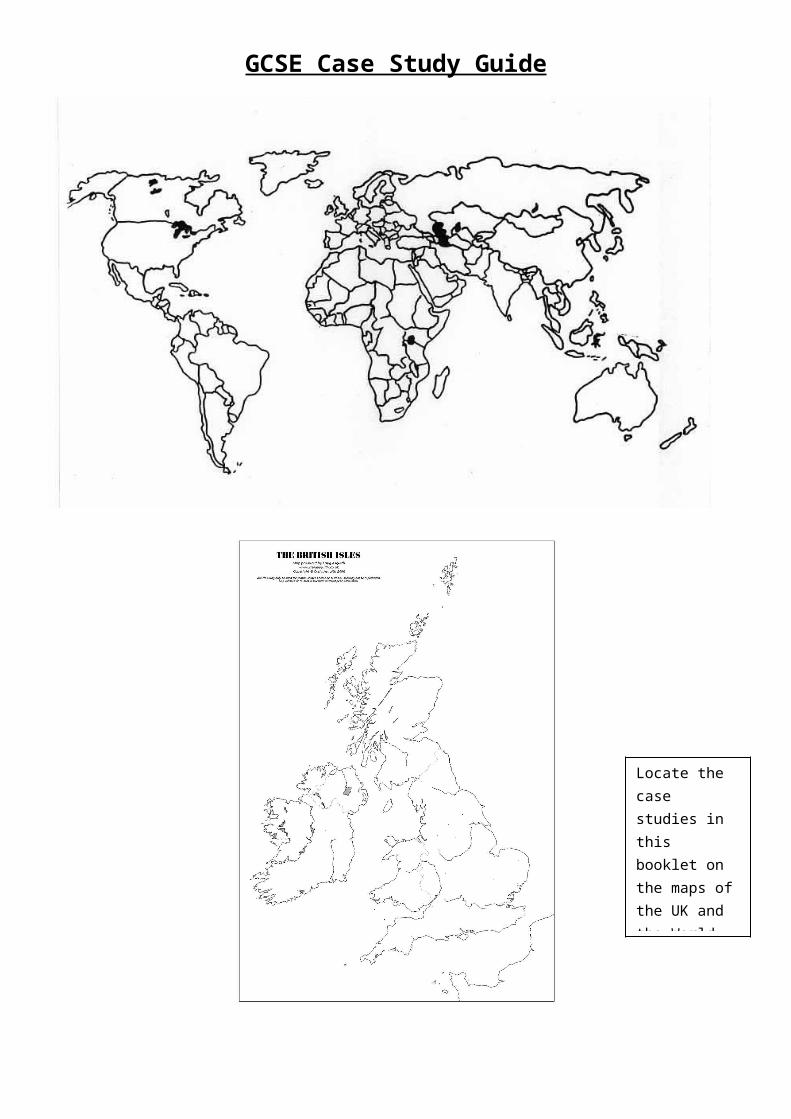
GCSE Case Study Guide
Locate the case studies in this booklet on the maps of the UK and the World
Papers 1F and 3H
Revise these case studies of the examination on the
2nd of June
In the exam remember to:
Locate your case study clearly, with a clear place name and where it is in the world. Maps can help here.
Link your case study directly to the question
Answer all parts of the question (sometimes there can 3 or 4 sections in one question!)
Quote some facts and figures about the place
Mention specific locations and place or scheme names o impress the examiner
Explain your ideas fully.
Bangalore, India
How land is used in an LEDC city
Bangalore is a city in central Southern India on a plateau 920m above sea level. It is the capital of Karnataka state and has grown from 159,000 people in 1901 to 2.7million in 1991.
First, we can see that the CBD is central to the city and is the focus point for all transport routes including train and roads. This is so that all people and goods can easily access the high rises, commerce and retail that surround Cubben Park.
Second, the quality of residential areas tends to decrease with distance from the CBD. This is because the rich occupy the most expensive zones close to the CBD and prefer to live close to the job opportunities. Also, because these areas are oldest the rich can afford and have developed security systems and feel safer living in numbers in this area.
Third, there are areas of informal Bustee or squatter settlements including Fraser town and Indirigandar scattered around the city. These are areas where landless poor people have occupied any area of land that is available and will continue to do so and build their own homes until moved on.
Finally, the industry is located at the edge of the city, along the roads and rail links and closest to the poorest quality housing. This is because they need the access for workers and raw materials and outgoing goods. They also get cheaper land here and
the high tech industries have access to the airport for international clients
.
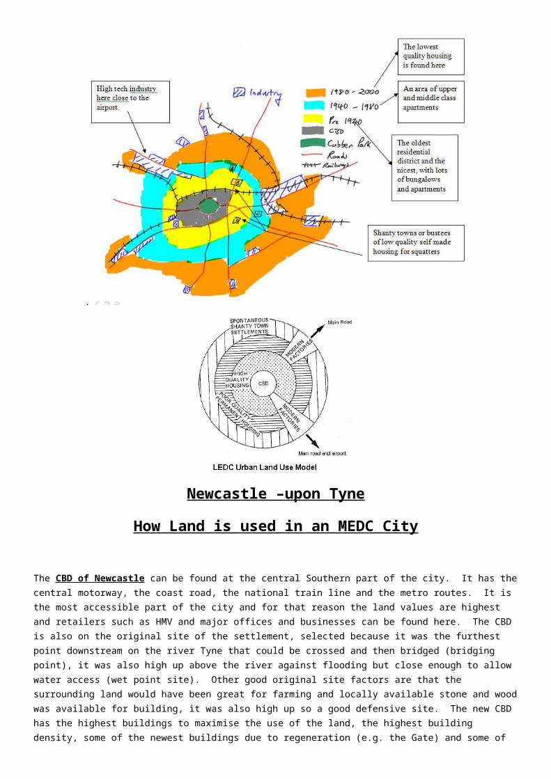
Newcastle –upon Tyne
How Land is used in an MEDC City
The CBD of Newcastle can be found at the central Southern part of the city. It has the central motorway, the coast road, the national train line and the metro routes. It is the most accessible part of the city and for that reason the land values are highest and retailers such as HMV and major offices and businesses can be found here. The CBD is also on the original site of the settlement, selected because it was the furthest point downstream on the river Tyne that could be crossed and then bridged (bridging point), it was also high up above the river against flooding but close enough to allow water access (wet point site). Other good original site factors are that the surrounding land would have been great for farming and locally available stone and wood was available for building, it was also high up so a good defensive site. The new CBD has the highest buildings to maximise the use of the land, the highest building density, some of the newest buildings due to regeneration (e.g. the Gate) and some of the oldest (e.g. the Theatre Royal), it also has entertainment and social functions such as the universities and the Civic centre.
The Industry is found in wedges that follow the river Tyne. This is the traditional secondary industries of armaments and ship building that needed the river and rail links to import heavy raw materials and export heavy finished goods. Some lighter footloose industries (including high tech firms) can be found on the edge of the city where the land is cheaper (e.g. Sage at Newcastle Great Park) and where the access is good.
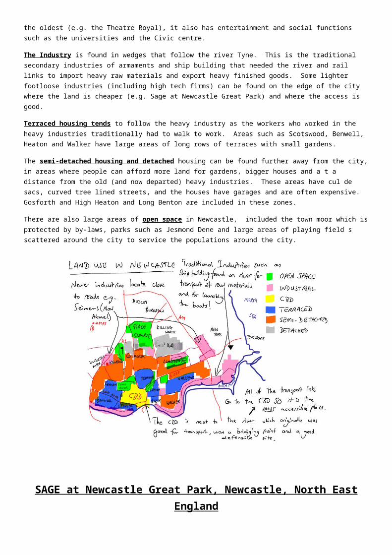
Terraced housing tends to follow the heavy industry as the workers who worked in the heavy industries traditionally had to walk to work. Areas such as Scotswood, Benwell, Heaton and Walker have large areas of long rows of terraces with small gardens.
The semi-detached housing and detached housing can be found further away from the city, in areas where people can afford more land for gardens, bigger houses and a t a distance from the old (and now departed) heavy industries. These areas have cul de sacs, curved tree lined streets, and the houses have garages and are often expensive. Gosforth and High Heaton and Long Benton are included in these zones.
There are also large areas of open space in Newcastle, included the town moor which is protected by by-laws, parks such as Jesmond Dene and large areas of playing field s scattered around the city to service the populations around the city.
SAGE at Newcastle Great Park, Newcastle, North East England
High Tech Industries in a MEDC
Sage is a leading supplier of business management software and services to 5.4 million customers worldwide. Sage was established in 1981. Sage is also a British company. Their origins are in the North East and the headquarters are still in Newcastle upon Tyne. They have tried to develop software that has been designed from the bottom up to meet the needs of British companies. But despite their humble origins, Sage is now a global organisation with over 6,000 employees worldwide. They have built a new £50 million headquarters at NGP.
Newcastle Great Park (NGP) is a state-of-the-art urban extension to Newcastle, based just four miles from the city centre. Once finished it is hoped that NGP will create a sustainable community boasting 80 hectares of commercial development and 2,500 new homes in a parkland setting of 442 hectares will be complete.
Reasons why SAGE are at NGP
The development lies adjacent to the A1, which will be widened and improved, and is within easy reach of the airport, providing excellent opportunities for national and international travel. The International airport is also close by (the planes fly over Sage when they land!).
The land is flat and easy to build upon, as it was previously greenbelt land.
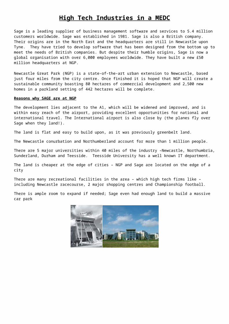
The Newcastle conurbation and Northumberland account for more than 1 million people.
There are 5 major universities within 40 miles of the industry –Newcastle, Northumbria, Sunderland, Durham and Teesside. Teesside University has a well known IT department.
The land is cheaper at the edge of cities – NGP and Sage are located on the edge of a city
There are many recreational facilities in the area – which high tech firms like – including Newcastle racecourse, 2 major shopping centres and Championship football.
There is ample room to expand if needed; Sage even had enough land to build a massive car park
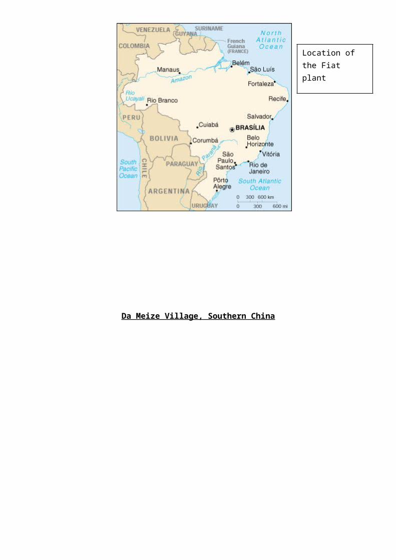
Fiat in Betim, Belo Horizonte, Brazil
The location of a Transnational Corporation in an LEDC
Trans National Companies are companies that operate globally. They tend to have their headquarters and management in their parent country and other factories around the globe. E.g. Nike is from the USA, but has branch factories in South East Asia.
Fiat is an Italian car manufacturer with an annual turnover of 48 Billion Euros which operates in 64 different countries.
Fiat opened a plant in Betem in Belo Horizonte in 1976 and this plant now produces 650 000 cars a year and employs 12,000 people.
The Brazilian government started a motor industry in Brazil for long term employment; this created a market for cars.
The state of Mina Gerais offered loans, grants and cheap land to Fiat, cutting their costs.
Fiat could sell its cars to all of South America.

There was a large pool of workers earning half of a British motor industry worker.
Strikes are rare in Brazil.
Fiat has since opened another factory in Brazil, with a £100million sweetener from the Brazilian Government
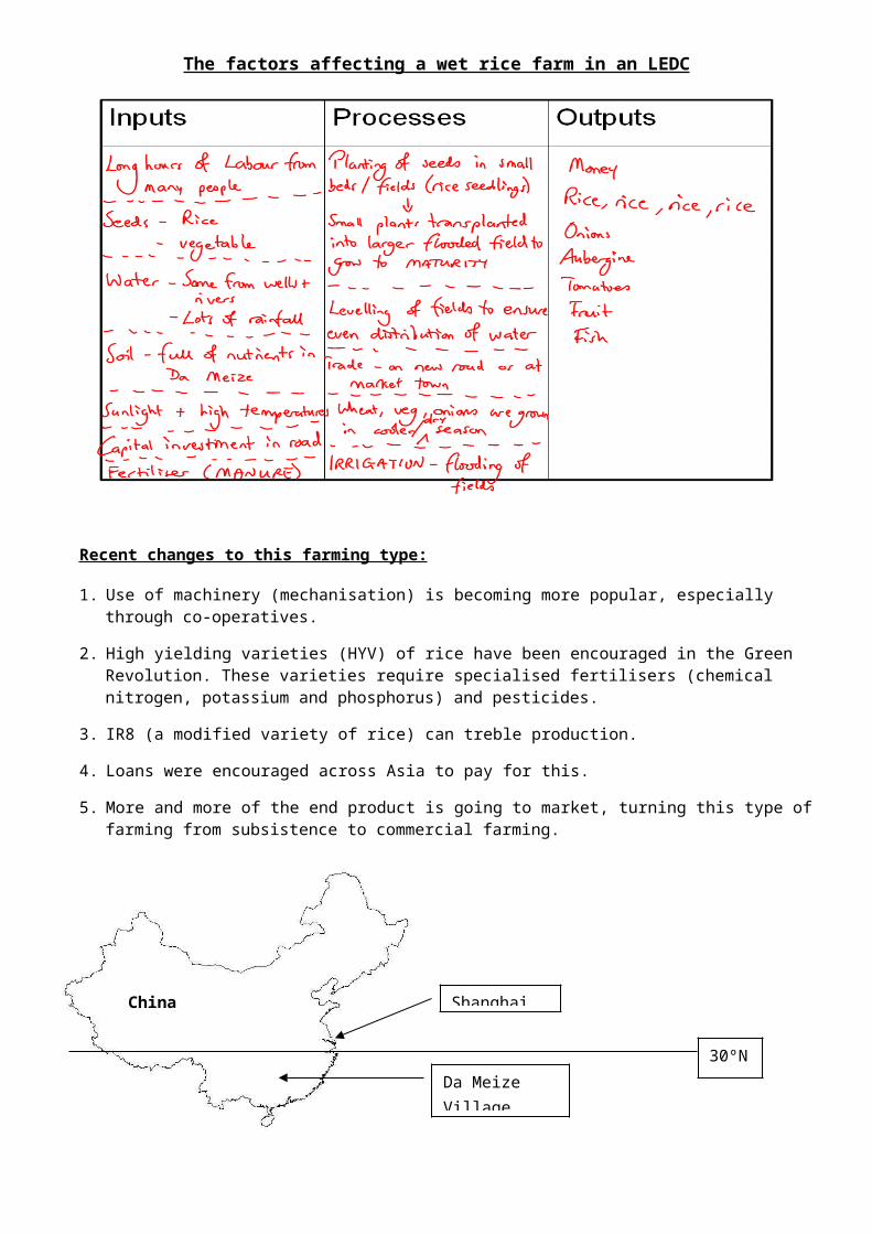
Da Meize Village, Southern China
Location of the Fiat plant
The factors affecting a wet rice farm in an LEDC
Recent changes to this farming type:
1. Use of machinery (mechanisation) is becoming more popular, especially through co-operatives.
2. High yielding varieties (HYV) of rice have been encouraged in the Green Revolution. These varieties require specialised fertilisers (chemical nitrogen, potassium and phosphorus) and pesticides.
3. IR8 (a modified variety of rice) can treble production.
4. Loans were encouraged across Asia to pay for this.
5. More and more of the end product is going to market, turning this type of farming from subsistence to commercial farming.
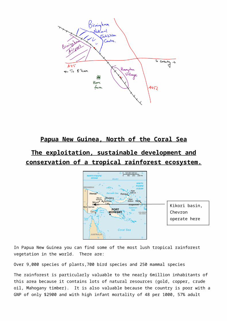
Home farm near to Birmingham, UK
Da Meize Village
China Shanghai
30ºN
Diversification and subsidies, the impact of the European Union on MEDC farming.
For many years British farmers had the price of their food subsidised by government. This support is being withdrawn leaving farmers with a shortfall in their income.
Home farm in Birmingham has been affected. The owner, Mr Redfearn, has over 200 hectares and fertile sandy soils. The land is relatively flat, rain fall is 700mm and summer temperatures of 16°C. He is therefore not limited by physical factors and has a mixed farm where livestock (cows, sheep and bulls) are raised and crops grown.
Mr Redfearn is more affected by human factors, Banbury and Uttoxeter are his local markets. His crops are sold to merchants who visit the farm.
Mr Redfearn has sold all of his cows because he was getting a very poor return on the milk they produced, only 8p a litre (for a product that sells for 45p a litre in the shops).
The withdrawal of subsidies has meant that Mr Redfearn’s income from his cereal crops dropped by £40,000 between 1998 and 1999.
These losses have meant that Mr Redfearn has had to do the following to diversify (find non farming activities to make money from his farm) and earn more income;
He stores up to 26 caravans on his farm for which he needed planning permission for £250 a year.
He will convert the old unused cow sheds into a bed and breakfast for businessmen who go to the nearby NEC in Birmingham.
Another possibility is for him to offer car parking at £3 per day.
Ponies are also kept on the farm at £100 a pony.
Other farmers have tried paintball, adventure sports, growing wood and turf to make money.
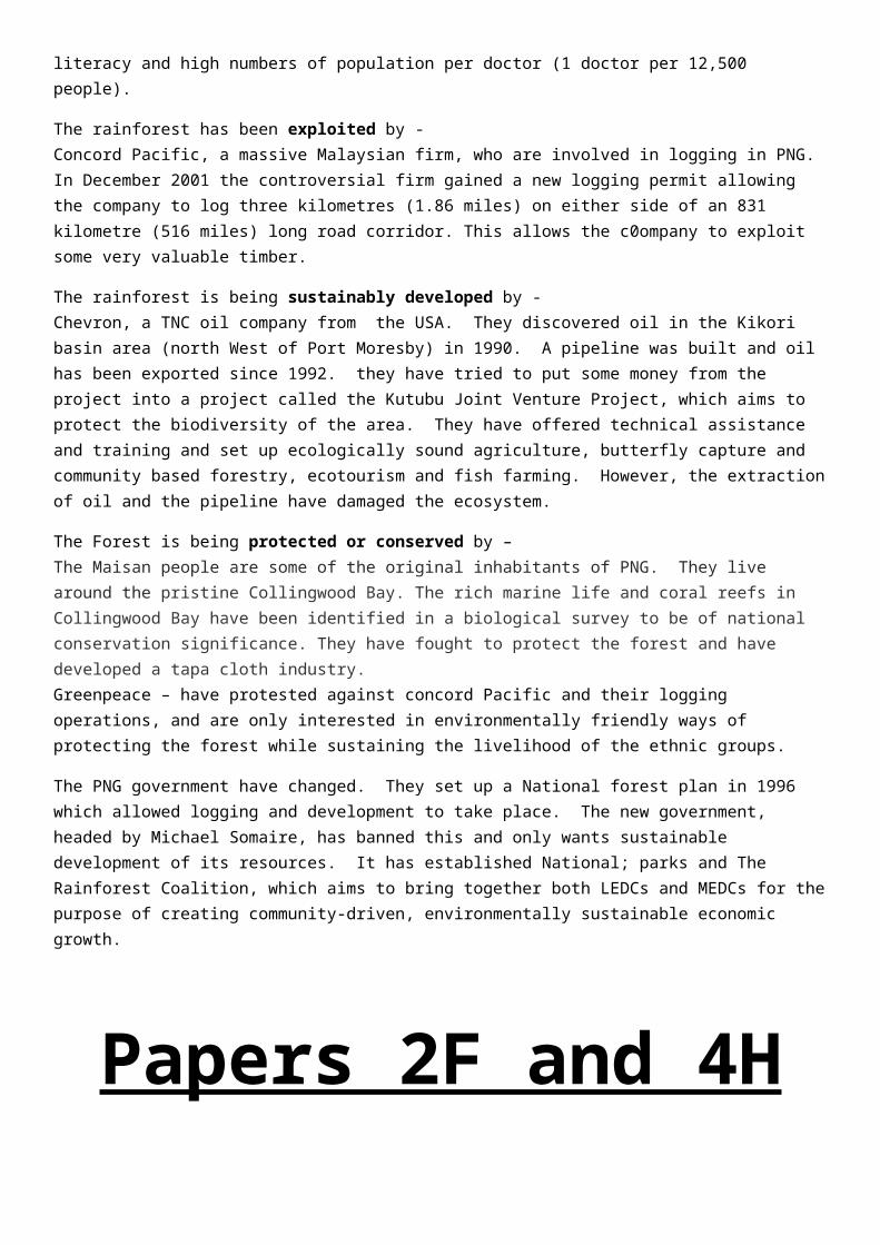
Papua New Guinea, North of the Coral Sea
The exploitation, sustainable development and conservation of a tropical rainforest ecosystem.
In Papua New Guinea you can find some of the most lush tropical rainforest vegetation in the world. There are:
Over 9,000 species of plants,700 bird species and 250 mammal species
The rainforest is particularly valuable to the nearly 6million inhabitants of this area because it contains lots of natural resources (gold, copper, crude oil, Mahogany timber). It is also valuable because the country is poor with a GNP of only $2900 and with high infant mortality of 48 per 1000, 57% adult literacy and high numbers of population per doctor (1 doctor per 12,500 people).
The rainforest has been exploited by - Concord Pacific, a massive Malaysian firm, who are involved in logging in PNG. In December 2001 the controversial firm gained a new logging permit allowing the company to log three kilometres (1.86 miles) on either side of an 831 kilometre (516 miles) long road corridor. This allows the c0ompany to exploit some very valuable timber.
The rainforest is being sustainably developed by - Chevron, a TNC oil company from the USA. They discovered oil in the Kikori basin area (north West of Port Moresby) in 1990. A pipeline was built and oil has been exported since 1992. they have tried to put some money from the project into a project called the Kutubu Joint Venture Project, which aims to protect the biodiversity of the area. They have offered technical assistance and training and set up ecologically sound agriculture, butterfly capture and community based forestry, ecotourism and fish farming. However, the extraction of oil and the pipeline have damaged the ecosystem.
The Forest is being protected or conserved by – The Maisan people are some of the original inhabitants of PNG. They live around the pristine Collingwood Bay. The rich marine life and coral reefs in Collingwood Bay have been identified in a biological survey to be of national conservation significance. They have fought to protect the forest and have developed a tapa cloth industry.Greenpeace – have protested against concord Pacific and their logging operations, and are only interested in environmentally friendly ways of protecting the forest while sustaining the livelihood of the ethnic groups.
The PNG government have changed. They set up a National forest plan in 1996 which allowed logging and development to take place. The new government, headed by Michael Somaire, has banned this and only wants sustainable development of its resources. It has established National; parks and The Rainforest Coalition, which aims to bring together both LEDCs and MEDCs for the purpose of creating community-driven, environmentally sustainable economic growth.
Kikori basin, Chevron operate here
Papers 2F and 4HRevise these case studies for the examination on
9 th June. Topics include Managing Hazards and Managing
Urban areas.
A tropical storm in a MEDC
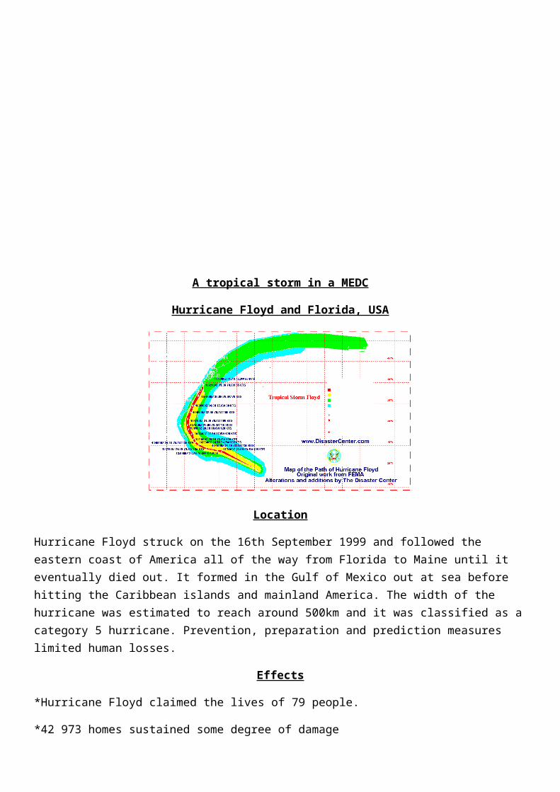
Hurricane Floyd and Florida, USA
Location
Hurricane Floyd struck on the 16th September 1999 and followed the eastern coast of America all of the way from Florida to Maine until it eventually died out. It formed in the Gulf of Mexico out at sea before hitting the Caribbean islands and mainland America. The width of the hurricane was estimated to reach around 500km and it was classified as a category 5 hurricane. Prevention, preparation and prediction measures limited human losses.
Effects
*Hurricane Floyd claimed the lives of 79 people.
*42 973 homes sustained some degree of damage
*14 states from Florida to Maine were effected
*Agricultural costs were estimated at $1 billion
*47 people died in North Carolina after 500mm of rain flooded 30 000sq km
Costs of rebuilding £4 Billion
Solutions and Management
Prediction - The National Hurricane Centre tracked the storm using its satellites, this allowed 4 million people to be evacuated.
Preparation - The evacuation was well planned, supported by the army and hundreds of hurricane shelters.
Prevention - People in the USA are educated on how to survive a hurricane by the government, tips given include turning off gas, removing loose objects from outside and stocking up on medical supplies, a radio, food and water.
Buildings are well constructed to withstand high winds, floods and storm surges.
Aid – The USA relies on internal aid during emergencies from its own government, the US government gave £1.5 billion and whilst FEMA (federal Emergency Management Agency) gave £0.8Billion
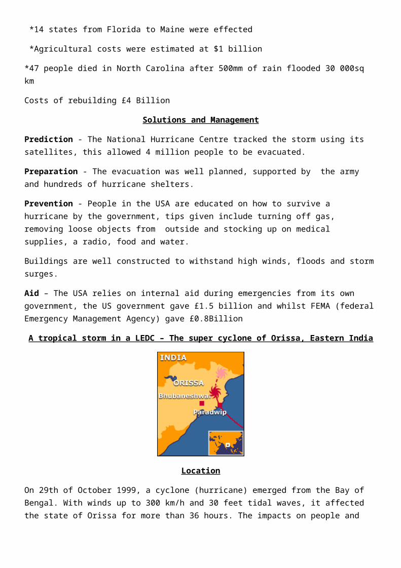
A tropical storm in a LEDC – The super cyclone of Orissa, Eastern India
Location
On 29th of October 1999, a cyclone (hurricane) emerged from the Bay of Bengal. With winds up to 300 km/h and 30 feet tidal waves, it affected the state of Orissa for more than 36 hours. The impacts on people and the environment were massive because of poor preparation, a lack of warning systems and very low literacy rates in the region (52%).
Effects
• 20,000 people and 700,000 cattle died.
• 90 million trees have been uprooted or damaged.
• 20 million people were made homeless
• 5 million farmers are out of work
• 1.2 million hectares of standing cropland were destroyed.
• £1.5Billion damage
Solutions
• Preparation and Prediction – The Indian government saw the development of the cyclone on it’s satellites but couldn’t warn people because of low literacy rates (49%), poor access to radios and the isolated nature of many villages.
• Prevention - There are only 27 cyclone shelters in this region for over 20 million people who live in the state. Building codes do not protect buildings against the forces of cyclones.
• Response - It took three days for relief efforts to begin. Five days after the storm, the co-ordination centre consisted of six workers, two telephones and a fax machine. Fishermen have now been issued with radios following the storm so that they can warn each other and people on land if there are future cyclones.
• Aid - India turned down a United Nations offer for an international fund-raiser, but countries including the US, Britain, Canada and Germany sent donations. About $20.8m had been pledged by March. The Indian government tried to deal with the disaster on its own initially.
A case study of an Earthquake in an MEDC – Kobe Earthquake in Japan, 1995
Kobe is located farther than many other cities in Japan from a destructive margin where 2 oceanic plates the Pacific and Philippine plates, are pushed under the Eurasian plate. At 5.46am on January 17th 1995. The Kobe earthquake was powerful (magnitude 6.9 ), the epicentre was only 20km southwest of the city and the focus was only about 16kms below the surface. 10million people live in this area. This is a recipe for disaster. More than 5000 people perished and 300, 000 people were made homeless.
People were trapped under rubble and traumatised. More than 102,000 buildings were destroyed in Kobe. The local government‘s estimate of the cost to restore the basic infrastructure of the city was about £100 billion.
1) The worst effected area was in the central part of Kobe including the main docks and port area. This area is built on soft and easily moved rocks, especially the port itself which is built on reclaimed ground. Here the ground actually liquefied and acted like thick soup, allowing buildings to topple sideways.
2) Emergency aid for the city needed to use damaged roads but many of them were destroyed during the earthquake.
3) Raised motorways collapsed during the shaking. Other roads were affected, limiting rescue attempts.Most new buildings and roads have, in the last 20 years, been designed to be earthquake proof, schools and factories have regular earthquake drills, etc. Despite this, many older buildings still collapsed or caught fire. This led to many blocked roads and massive problems of homelessness.
Initial short term responses Telephones and other communication services were put out of action making
communication slow and difficult. Electricity and water supplies were badly damaged over large areas. This meant no
power for heating, lights, cooking, etc. Clean, fresh water was in short supply until April 1995. The government and city authorities were criticised for being slow to rescue people and for refusing offers of Aid from other countries.
Many people had to sleep in cars or tents in cold winter conditions. Locals dug through the rubble to help others.
Long term responses
Water, electricity, gas, telephone services were fully working by July 1995 The railways were back in service by August 1995
A year after the earthquake, 80% of the port was working but the Hanshin Expressway was still closed.
By January 1999, 134,000 housing units had been constructed but some people were still having to live in temporary accommodation.
New laws were passed to make buildings and transport structures even more earthquake proof.
More instruments were installed in the area to monitor earthquake movements.
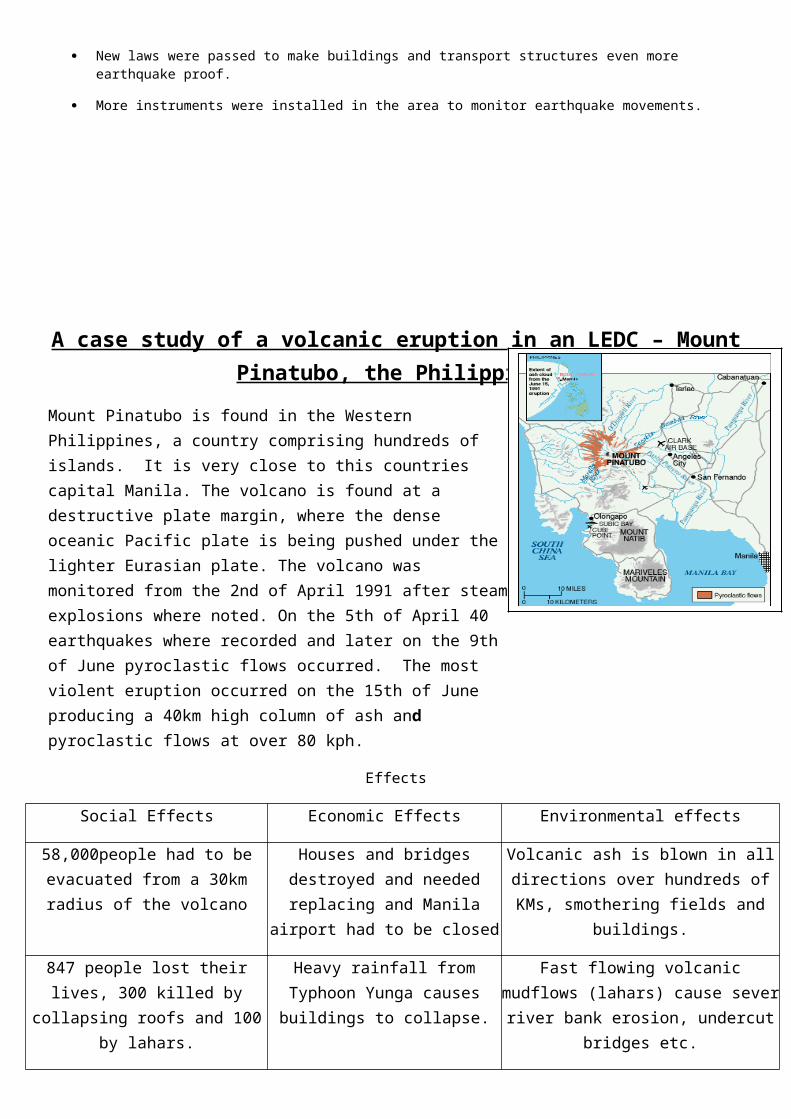
A case study of a volcanic eruption in an LEDC – Mount Pinatubo, the Philippines
Mount Pinatubo is found in the Western Philippines, a country comprising hundreds of islands. It is very close to this countries capital Manila. The volcano is found at a destructive plate margin, where the dense oceanic Pacific plate is being pushed under the lighter Eurasian plate. The volcano was monitored from the 2nd of April 1991 after steam explosions where noted. On the 5th of April 40 earthquakes where recorded and later on the 9th of June pyroclastic flows occurred. The most violent eruption occurred on the 15th of June producing a 40km high column of ash and pyroclastic flows at over 80 kph.
Effects
Social Effects Economic Effects Environmental effects
58,000people had to be evacuated from a 30km radius of the volcano
Houses and bridges destroyed and needed replacing and Manila airport
had to be closed
Volcanic ash is blown in all directions over hundreds of KMs, smothering fields and
buildings.
847 people lost their lives, 300 killed by collapsing roofs and 100 by
lahars.
Heavy rainfall from Typhoon Yunga causes buildings to collapse.
Fast flowing volcanic mudflows (lahars) cause sever river bank erosion, undercut
bridges etc.
1.2 million people lost their homes around the volcano and had to
migrate to shanty towns in Manila.
Farmland destroyed by falling ash and pumice, unusable for years, the
1991 harvest was destroyed and 650,000 people lost their jobs
Global cooling caused by ash in the atmosphere of 0.5°C
Prediction, Prevention, Aid and Monitoring
Prediction Prevention Preparation
What they actually did
75,000 people were evacuated due to accurate predictions. There was no monitoring until the 3rd of April but seismometers were put into place.
The United States Geological Service helped to predict the disaster
75,000 people evacuated up to a radius of 30km.
USA air force helicopters helped.
Alert systems put into place to warn of eruption.
Government Shelters.
Evacuation camps built for refugees.
Warning sign like gas and steam looked for. Long and short term
aid organized especially from the Red Cross and the United States
What they could have
Set up permanent monitoring points, divert lava flows with use of
Placed strategies for long term aid and disease
Storage of medical supplies food and water in preparation for
done dynamite, or use satellite images to look upon volcano site for changes in
land surface.
control in evacuations prepared for.
disaster.
A study of Inner city decline – Newcastle Upon Tyne
Tyne and Wear Development Corporation (TWDC)
The riverside areas of Newcastle upon Tyne were responsible for the cities incredible growth and wealth during the industrial revolution. Heavy industries such as the Armstrong armaments works and ship building (e.g. Swan Hunters) employed tens of thousands of people from riverside communities in Newcastle such as Elswick and Scotswood. Overseas competition in these industries in the 1960s, 70s and 80s led to the decline and closure of these industries and the communities suffered as a result.
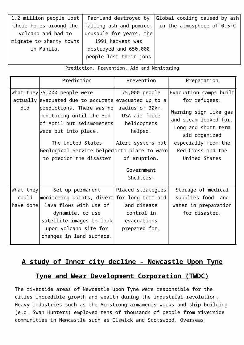
The graph shows this decline in these riverside areas in comparison to the rest of Newcastle. The graph shows that the West End is a poorer area than Newcastle overall. There are a lot more people who live in a council property in the West End than Newcastle. This could be because of low monthly wages given to the people at the West end, this might be because of the people being under qualified in the area from lack of education. This also could be proven by the 30% of students still at school at the age of seventeen compared to the Newcastle area of 41%. This means that the area overall is under qualified and a lot poorer than Newcastle. Unemployment was an incredible 42%.
Tyne and Wear Development Corporation (TWDC) – large scale regeneration
West End City Challenge
Aims Create new business districts or modern offices and industrial estatesIncreasing employment through grants and training
Reviving riversides as a place to liveImproving environment and landscaping
Create new jobsImprove educational achievements
Support training and employment opportunities
Funding £430 million of government money attracting £1,114 million of private sector money
£37.5 million of government money over 5 years, which attracted £80 million of private cash.
Comparison of Newcastle to the West End
0102030405060
non-
whi
tehe
adho
useh
old
child
ren
from
aon
e pa
rent
fam
ily
Mal
eun
empo
lym
ent
Hou
seho
lds
with
the
use
ofth
e ca
r
17 y
ear o
lds
still
at s
choo
l
Cou
ncil
rent
edac
com
odat
ion
Area of problem studied
Perc
enta
ge Newcastle (%)Westend (%)

Projects Mainly Flagship projects including:Newcastle Business park - £140 million development of 25ha of offices on
previous derelict land British Airways have offices there.Newcastle Arena
Newcastle quayside – cost £170 million
Local community based projects including:Extension to Newcastle Breweries – creating 280 jobs
Renovation and gentrification of old Scotswood housingEmploying extra teachers and free alarm clocks for students
John Marley community centre for trainingCCTV to combat crime
Evaluation TWDC has transformed the Newcastle Quayside but has been less successful at regenerating housing estates. Many local communities had to
be relocated to make way for the big developments.
WECC has tried to benefit local people in improving their local environment. Despite strides being made in local
housing many properties remain derelict and children still fail to achieve in school
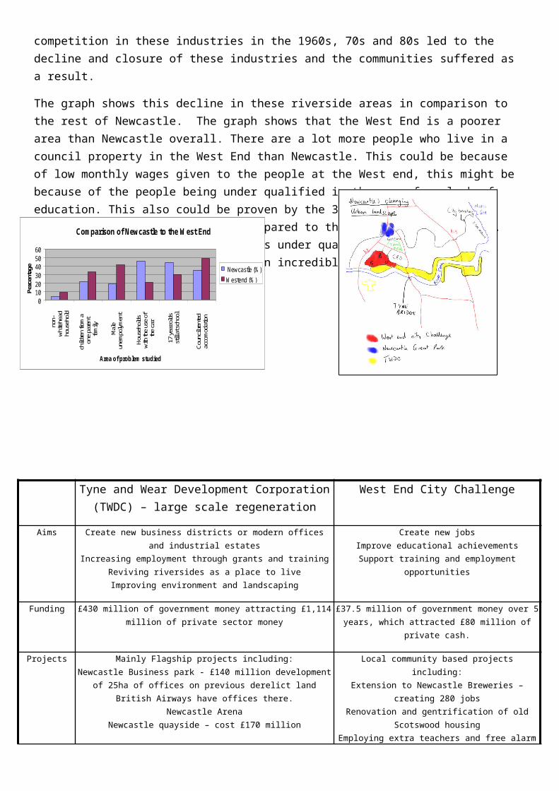
A study of edge of city developments – Newcastle Great ParkNewcastle Great Park is a major housing and commercial development that has been built on a Greenfield site (land that has never been built upon before) within the greenbelt (an area of land that is protected by law from development) of Newcastle. It is located in the north of Newcastle next to Gosforth and the government gave special permission for this development to go ahead. There are many different interest groups who think the development should go ahead including the developers (Persimmons homes), the government and the council and some home owners. Conservationists and environmentalists, some home owners and some urban planners think the scheme is a bad idea. The table below outlines the arguments for and against
Arguments for NGP Arguments against NGP
1. 2,500 new homes in a parkland setting of 442 hectares will be complete. Useful for richer residents and generating income for the developers.
2. There will be 80 hectares of commercial development which could generate jobs. Already, the £50m headquarters for Newcastle computer group Sage have been completed. It is expected the software firm's 575,000 sq ft building headquarters will provide jobs for 1,500 workers within two years.
3. There is an integrated transport plan which will see every home not more than 400 metres from a bus stop, 27km of cycle routes in and around NGP, a discount cycle purchase scheme for residents and a car share database on the Internet.
4. A full time ranger will be employed to manage the country park to ensure local wildlife conservation
5. The development lies adjacent to the A1, which will be widened and improved, and is within easy reach of the airport, providing excellent opportunities for national and international travel.
6. It is hoped that the scheme will slow down the net loss of 1,500 people per year who migrate from Newcastle.
1. The three-storey properties priced from £188,000 are well beyond the average wage of people in Newcastle.
2. Environmentalists are concerned about the impact upon Red Squirrel (an endangered species) and deer populations which inhabit this area North of Newcastle.
3. The NGP housing plans contradict the principles of no/little development in the Green Belt. The greenbelt was designed to prevent urban sprawl into countryside areas which have recreation and agricultural uses.
4. There is space for around 20,000 high quality homes on brownfield sites near to the city centre in the East and West end of the city. These areas (e.g. Scotswood, Benwell and Byker) are in decline since the loss of the shipping industry and are in need of a boost.
5. There is no guarantee of job creation.
6. Traffic volumes in Gosforth and Newcastle city centre will increase.
7. Improving inner-city areas could slow down out migration.
A study of a city in an LEDC experiencing rapid growth – Rio De Janeiro, Brazil
Rio De Janiero is on the south-east coast of Brazil. It has a large port running through it and lies on the tropic of Capricorn. Its population was 6.9 million in 1960 and stands at 11.8 million today.
Causes of problems.
Rio De Janeiro is affected by urbanisation caused by Rural to Urban migration and high levels of natural increase. This has resulted in the growth of many large favelas.
Rochina is a favela which is home to over 100,000 people on one single hillside. Although the buildings have been improved, many are built by the people who live in them and lack some basic amenities such as toilets. There are no refuse collection facilities, schools are over crowded and drug crime is rife.
Rio also suffers from urban pollution and traffic congestion.
Rio cannot grow because of physical factors, to the North and West are mountain ranges, to the South and East lies water. This makes the traffic congestion problems and overcrowding in outlying shanty towns worse.
Solutions to the problems in Rio
• A new town has been built (see map) at Barra da Tihuca. This has shopping malls, busses, good schools, transport links and holds over 100,000 people. It is mainly for middle class residents of Rio who can afford to move. It is separated from Rio by a mountain range which had to be tunnelled to allow access to Rio.
• Within the Favelas the government has assisted people in improving their homes. Breeze blocks and other materials (pipes for plumbing etc) were given as long as people updated their homes.
• The government also moved a lot of people out of shanty towns and into low cost, basic housing estates with plumbing, electricity and transport links. The waiting list for these properties was huge.
• Community policing has been encouraged with greater links between the police and the local communities and businesses, but drug gangs still pose a huge problem.
A study of the causes and consequences of environmental problems in a city – Cairo, Egypt
Cairo is located to the east of the river Nile. This built up area has an airport to the north and to the east of the built up area is Eastern desert. This poses as a problem because the area now cannot expand to the west, due to the Nile and cannot expand to the east due to the desert region. The only way is north or south. It has grown from 4.5million in 1960 to 16million people in 2000.
Cairo’s main problem is overcrowding, and due to this overcrowding it means there is a great problem with pollution. Cairo is overcrowded for two reasons:
• people have moved from rural areas to the urban city in search of jobs and a better lifestyle
• the life expectancy has risen due to advances in medical care from 41yrs to 64 yrs
Cairo's rapid population influx now means that there is over 30,000 people per square kilometre.
This increase in population has lead to an increase in pollution:
PROBLEM: PROBLEMS CAUSED WHAT CAIRO GOV. IS DOING
AIR POLLUTION
Fumes from Cairo’s 2 million vehicles combined with suspended particulate matter plus sand blown into urban areas, the concentration of air particulates is 5-10 times higher in Cairo than the recommended average. This is worst in the industrial areas and Cairo Old Town- this causes high blood pressure kidney problems, infertility and an IQ drop it kills 10-25000
• Changed to unleaded petrol
• Cairo Air Improvement Project has monitoring stations and car checks. it has 36 monitoring stations funded by US aid which gives $60 million. Have produced a programme that reduces the emissions
people
Gas emissions are 5-10 times higher than WHO recommends
from air filters- new equipment and smelters and relocation of factories; they also have vehicle emission testing randomly.
LAND POLLUTION
10,000 tonnes of waste Waste incinerators brokenNo health waste disposalHazardous waste is helped to spread by rats and other vermin
• Cairo Cleaning and Beautification Agency only collect 60% of waste
NOISE POLLUTION
• Cars in rush hour traffic mean roads are gridlocked throughout the day and night
• Night clubs open late
• Boats on river
• Metro-system to reduce cars
• Banned the use of nightclub boats on the River Nile
Nissan, Sunderland
The location of a secondary/manufacturing industry
Nissan invested £50million initially when they set up in 1984, and have invested £2.1billion in total.
In 1984 land was sold to Nissan at a greatly reduced price, and rates were free for a limited time. All of the roads etc were put in for Nissan for free.
£40million grant recently given for Micra contract.