case study jamaica: approach, methods and key findings · case study jamaica: approach, methods and...
TRANSCRIPT

UNCTAD Regional Workshop 5 – 7 December 2017, Bridgetown, Barbados
“Climate Change Impacts and
Adaptation for Coastal Transport Infrastructure in the Caribbean”
Case Study Jamaica: approach,
methods and key findings
By
David A.Y. Smith
Smith Warner International, Jamaica
This expert paper is reproduced by the UNCTAD secretariat in the form and language in which it has been received. The views expressed are those of the author and do not necessarily reflect the views of the UNCTAD.

1
Case Study for Jamaica
CLIMATE CHANGE IMPACTS ON COASTAL TRANSPORT
INFRASTRUCTURE IN THE CARIBBEAN: ENHANCING THE ADAPTIVE
CAPACITY OF SMALL ISLAND DEVELOPING STATES
REGIONAL WORKSHOP
Prepared for:
United Nations Conference on Trade
and Development
Presented by
David A Y Smith, PhD., P.Eng 05 Dec 2017
∗ Introduction to project
∗ Profile of Jamaica
∗ Critical transport infrastructure
∗ Asset vulnerability to climate stressors
∗ Potential adaptation options
∗ “Take-aways” at a regional level
Overview

2
Introduction
∗ Climate change has most dramatic impacts on
(a) small island countries,
(b) countries with low-lying coastal areas,
(c) countries with areas prone to natural disasters
∗ Caribbean located in “hurricane alley” of the Atlantic
∗ Caribbean islands are small with mountainous interiors and populated narrow coastal plains
∗ Caribbean economies depend on natural resources which means limited financial, technical and institutional capacity for adaptation
Introduction cont’d
∗ Climate Change Policy Framework for Jamaica (released in September 2015) creates an institutional mechanism and structures to facilitate the development, coordination and implementation of policies, sectoral plans, strategies, and legislation to address the impacts of climate change.
∗ One of the (then) government’s highest priorities was “building resilience to the impacts of climate change”
∗ Sectors needing attention were stated as “…tourism, agriculture, fisheries, forestry, water, energy, industry, human settlements and coastal resources, marine resources, human health, transportation, waste management, education, finance and disaster risk reduction and response management.”

3
Introduction cont’d
∗ Transportation (ports and airports) is crucial to economic development:
∗ Would be cut off (financially and culturally) from region without it
∗ Major import channel - bringing in vital goods needed for survival and sustenance
∗ Brings in visitors – major income earner
∗ Project objectives
∗ Understand possible climate change impacts on costal transport infrastructure – airports and seaports
∗ Suggest appropriate response measures
Jamaica’s ProfileGeography, Demography, Economy, Climate

4
∗ 4th largest island country in the Caribbean Sea
∗ 10,990km2, approx. 234km long and 80km wide
∗ Volcanic origin, mountainous interior, with a narrow, discontinuous coastal plain around the edges
∗ Bays, small cays and attractive white-sand beaches are a large draw for tourists
∗ >100 rivers, most of them small, unexplored and not navigable
Jamaica’s Profile: Geography
Due to Jamaica’s prime location (almost in the centre of the Caribbean) and close proximity to the Americas, Jamaica is advantageously positioned to become a gateway between the USA and the Caribbean and Latin Americas.
∗ Approximate population 2.8 million (almost 50/50 split between males and females)
∗ Population growth rate is decreasing – this is due to decreasing birth rate and is also influenced by migration
∗ Migration has a significant effect on the island’s socio-economics:∗ Local migration (rural to cities) puts stress on the resources of already dense
urban areas ∗ Foreign migration causes “brain drain”. Mostly the more educated migrate -
85 per cent of Jamaicans who have migrated are tertiary graduates
∗ Jamaica’s population has limited skilled resources. The country’s work force is comprised as follows:∗ 69% have received no training whatsoever∗ 24% are equipped with either a vocational certificate or degree∗ 6% had received on-the-job training or apprenticeship
∗ The labour force breakdown by sector is: Agriculture 17%, Industry 19% and Services 64%.
Jamaica’s Profile: Demography

5
∗ Jamaica has one of the slowest growing economies compared to other developing countries due to “chronic state of fiscal imbalance, underutilization of productive capacity, economic waste of capital and concentration of capital investment in highly capital-intensive sectors and economic enclaves” and related to “crime and violence, corruption, taxation, supply of electricity, finance and macroeconomic instability.”
∗ Over the last 10 years GDP ranged from 12.0 - 14.75 billion US dollars, very small (~ 0.02%) compared to world economy
∗ Services sector accounts for > 70% of GDP; foreign exchange is earned through tourism, remittances and bauxite (collectively ~30% of GDP)
Jamaica’s Profile: Economy
Given the slow growth and fragility of Jamaica’s economy, the impact of climate change, natural disasters or any other disruption in services is likely to have large and far-reaching effects.
Jamaica’s Profile: Climate
Existing rainfall and temperature

6
Rainfall means: (A) Annual, (B) Nov -Jan(C) Feb-Apr(D) May-Jul(E) Aug-Oct
Jamaica’s Profile: Climate
∗ Jamaica lies in the North Atlantic hurricane belt, and is more frequently hit by tropical storms, but also significantly affected by major hurricanes
∗ Note no Cat 5 storms before 1980 (Hurricane Allen); no recorded Cat 4 storms before 1915 in the Kingston area, and none before 1932 in the Montego Bay area.
∗ Larger intensity storms have only been incident on the island within the last 90 years of record for the Category 4 storms and within the last 30 years of record for the Category 5 storms.
Jamaica’s Profile: Climate
7
Long-term climate data indicates:
∗ Warming trend in Jamaican temperatures
∗ Annual and seasonal rate of temperature increase ranges from 0.20 – 0.31 °C per decade
∗ Frequency of very hot days and nights has increased by 6% (an additional 22 days per year) every decade
∗ Frequency of ‘cold’ nights has decreased at a rate of 4% fewer ‘cold’ nights i.e. 14 fewer cold nights in every year per decade
∗ Large increases in sunshine hours Mar-Aug
∗ Increases in annual & seasonal wind speed
Jamaica’s Profile: Climate
Climate models for Jamaica predict:
∗ Increasing temperatures
∗ Increasing numbers of hot days/nights
∗ Decreasing numbers of cold days/nights
∗ Decreases in annual rainfall
∗ Increased drying
∗ Fewer extreme rainfall events
∗ Increase in sunshine hours
∗ Increase in mean wind speeds over Jamaica
Jamaica’s Profile: Climate
8
∗ Hurricane activity in the Caribbean has increased dramatically since 1995, attributed to recent warm phase of Atlantic multi-decadal oscillation
∗ Recent studies indicated a decrease in the frequency of storms in warmer climates BUT there is an indication that the intensity of hurricanes will increase
∗ Sea levels around the Caribbean show a rising trend (about 3mm/year since early 1990’s)
Profile: climate
Critical Transport Infrastructure Airports and Seaports

9
2 international airports: Donald Sangster International Airport (DSIA)Norman Manley International Airport (NMIA)
Map of Jamaica showing two international airports (shown as planes), major roadways (yellow lines) and two ports (small red triangles)
2 major seaports:Kingston Container Terminal (KCT)
Historic Falmouth Cruise Port (HFCP)
Critical transport facilities: overview
Facilities Private
ConcessionairesGovernment
Authorities/BoardsGovernment
Ministry
Ministry of Transport and
Mining
Airports Authority of
Jamaica
MBJ Airports Limited
Donald Sangster International
Airport
NMIA Airports Limited
Norman Manley International
Airport
Port Authority of Jamaica
Falmouth Jamaica Land
Company
Historic Falmouth Cruise
Port
Kingston Freeport
Terminal Ltd.
Kingston Container Terminal

10
Critical transport facilities: Donald Sangster International Airport
Because of its location on the north coast, near hotels and tourist attractions, DSIA is a critical tourist gateway
Critical transport facilities: Donald Sangster International Airport

11
∗ One runway (2662.4m long by 46m wide) with 3 taxiways leading to it
∗ Runway has constant elevation of 1.37m above MSL along its entire length, except at easternmost end where elevation drops to 1.18m
∗ Runway averages 195m away from the coastline (144m at its closest and 222m at its farthest)
∗ One control tower
∗ Nineteen (19) gates
∗ 2 electrical feeders; 4 generators; fuel farms; JPS substations
Critical transport facilities: Donald Sangster International Airport
Plans for improvement:
∗ New concourse opened (2005)
∗ New customs hall, arrivals lobby and transport centre (2007)
∗ Relocation of immigrations hall and duty-free mall (2008)
∗ Some indication of long-term plans to lengthen the runway to accommodate larger plans
∗ NO plans to raise the runway (in the near to medium term)
Critical transport facilities: Donald Sangster International Airport

12
Critical Gateway for tourists:
∗ Roughly 72% of tourists entering the island arrive through DSIA
∗ Data from 2010 – 2015 showed on average 3.5 million passengers pass through the airport
Critical transport facilities: Donald Sangster International Airport
0
10'000
20'000
30'000
40'000
50'000
60'000
70'000
3'000'000
3'100'000
3'200'000
3'300'000
3'400'000
3'500'000
3'600'000
3'700'000
3'800'000
3'900'000
2010 2011 2012 2013 2014 2015
To
tal C
argo
and
Mai
l
Tota
l Pas
senge
rs
Total Passengers Total Cargo and Mail ∗ Numbers steadily increasing – both passenger traffic and cargo/mail traffic on the rise
Critical transport facilities: Norman Manley International Airport
Because of its location close to Kingston, NMIA is the “premier gateway to the nation’s capital”, and plays a critical role in Jamaica’s economic development.

13
Critical transport facilities: Norman Manley International Airport
∗ Located on the Palisadoes peninsula, ~20 minutes from Jamaica’s business centre, Kingston
∗ Provides air service mostly for business travel to and from Kingston as well as air cargo service
∗ Surrounded by Kingston Harbour (north) & Caribbean Sea (east & south)
∗ One runway: 2,716m long by 46m wide – 4 taxiways; +2.8m amsl
∗ Large air cargo facilities
∗ Terminal facility expansion and upgrade as well as ancillary service upgrades were completed in 2009
Critical transport facilities: Norman Manley International Airport

14
∗ NMIA is accessible only by one road, a 5km strip (Norman Manley Highway) that, until recently, was impassable during even minor storm events
Critical transport facilities: Norman Manley International Airport
20072013
Plans for improvement:
∗ Development of an ICAO compliant runway strip and runway end safety area (RESA) at each runway end without reducing current runway declared distances.
∗ Extension of the runway by an additional 500 metres, into Kingston Harbour.
∗ ICAO compliant taxiway separations for Code E operations (to be completed by 2020)
∗ NO immediate plans to raise the runway
∗ Terminal building upgrades
∗ Ancillary services improvements
Critical transport facilities: Norman Manley International Airport
15
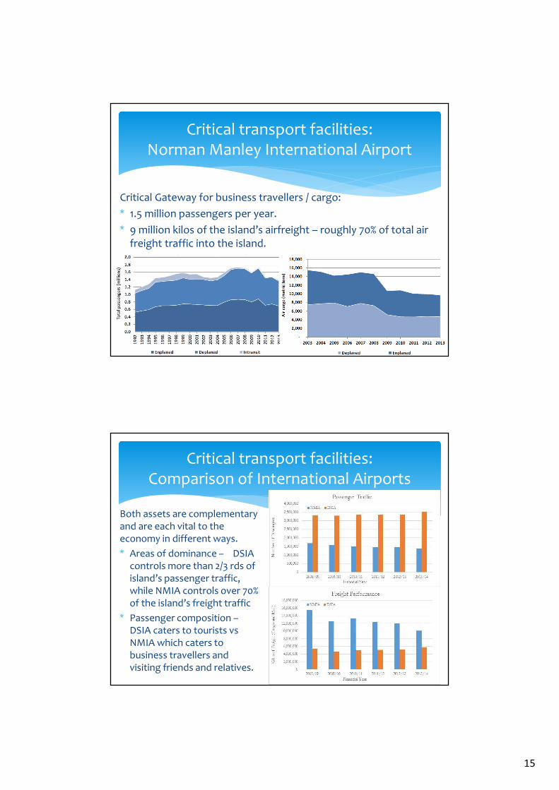
Critical Gateway for business travellers / cargo:
∗ 1.5 million passengers per year.
∗ 9 million kilos of the island’s airfreight – roughly 70% of total air freight traffic into the island.
Critical transport facilities: Norman Manley International Airport
Both assets are complementary and are each vital to the economy in different ways.
∗ Areas of dominance – DSIA controls more than 2/3 rds of island’s passenger traffic, while NMIA controls over 70% of the island’s freight traffic
∗ Passenger composition –DSIA caters to tourists vs NMIA which caters to business travellers and visiting friends and relatives.
Critical transport facilities: Comparison of International Airports

16
Critical transport facilities: Historic Falmouth Cruise Port
Because of its location (north coast) and capacity (can accommodate larger vessels), HFCP hosts more cruise ship callers to the island than any other cruise port.
∗ Opened for docking in March 2011
∗ Operated by Falmouth Jamaica Land Company, formed under a partnership between Royal Caribbean Cruise Lines and Port Authority of Jamaica.
∗ Newest facility to serve the Jamaican cruise industry
∗ Located on north coast near attractions, and conveniently located between tourist hubs Montego Bay (29km to the west) and Ocho Rios (95km to the east).
∗ Only one roadway access: off Trelawny St in the town of Falmouth. Because of the port’s location, it’s impossible to access without driving through the small town’s narrow, potholed roads, susceptible to flooding due to poor drainage
Critical transport facilities: Historic Falmouth Cruise Port

17
Critical transport facilities: Historic Falmouth Cruise Port
∗ Two berths: 340m on the western boundary and 335m metres on the eastern boundary, each berth features different draughts
∗ ~114,500m2 stretching from berth to inland boundaries
∗ EIA for the pier shows level of all pier structures at ~ +3.00m above Chart datum (no elevation data received to confirm)
Critical transport facilities: Historic Falmouth Cruise Port

18
Plans for expansion:
∗ Dredging of berths and boat channel to accommodate larger draught vessels
∗ HFCP facility would be the only Jamaican cruise port that will allow the berthing of two GENESIS/OASIS class vessels, with a passenger capacity each of 6,000 once planned expansion works are completed
Critical transport facilities: Historic Falmouth Cruise Port
∗ Number of calls has continuously increased since the port’s opening in 2011
∗ HFCP is responsible for ~50% of the total cruise ship passenger arrivals to the island
Critical transport facilities: Historic Falmouth Cruise Port

19
∗ HFCP is a critical player in the island’s cruise ship industry
∗ Cruise passenger arrivals account for 41% of the total visitor arrivals to the island
∗ Damage of the port facility would have massive effects on Jamaica’s ‘stop-over’ tourism trade
Critical transport facilities: Historic Falmouth Cruise Port
∗ Locally the port is a huge contributor. Approx. 1000 staff are employed in the plaza of the port. Further persons are employed in tour operations etc.
Critical transport facilities: Kingston Container Terminal
KCT is one of Jamaica’s prime assets –responsible for the bulk of domestic importation and transhipment in the island’s trade.
20
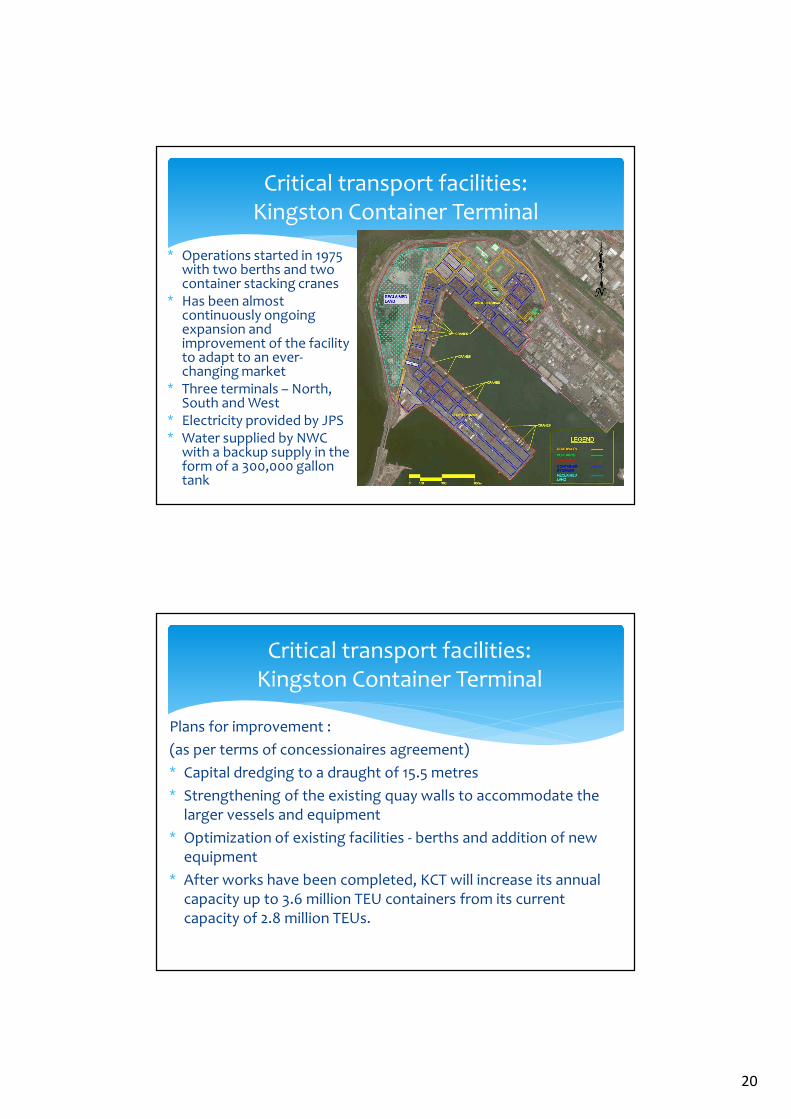
∗ Operations started in 1975 with two berths and two container stacking cranes
∗ Has been almost continuously ongoing expansion and improvement of the facility to adapt to an ever-changing market
∗ Three terminals – North, South and West
∗ Electricity provided by JPS ∗ Water supplied by NWC
with a backup supply in the form of a 300,000 gallon tank
Critical transport facilities: Kingston Container Terminal
Plans for improvement :
(as per terms of concessionaires agreement)
∗ Capital dredging to a draught of 15.5 metres
∗ Strengthening of the existing quay walls to accommodate the larger vessels and equipment
∗ Optimization of existing facilities - berths and addition of new equipment
∗ After works have been completed, KCT will increase its annual capacity up to 3.6 million TEU containers from its current capacity of 2.8 million TEUs.
Critical transport facilities: Kingston Container Terminal

21
Critical transshipment hub:
∗ Roughly 8 million metric tonnes of transhipment cargo is being handled annually
∗ The bulk of the business is transhipment - of the total amount handled, about 86% were transhipments and 12% were domestic containerized cargo
∗ ECLAC ranked the KCT as 8th in Latin America and the Caribbean based on throughput.
Critical transport facilities: Kingston Container Terminal
Four times as many goods are being imported than are being exported, highlighting the criticality of the KCT for imports. Close to a million metric tonnes of cargo are brought into the island on an annual basis through this port alone.
Critical transport facilities: Kingston Container Terminal
22
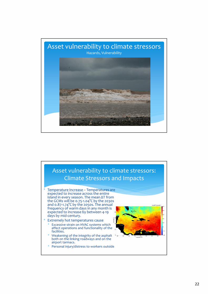
Asset vulnerability to climate stressorsHazards, Vulnerability
Asset vulnerability to climate stressors: Climate Stressors and Impacts
∗ Temperature Increase – Temperatures are expected to increase across the entire island in every season. The mean ΔT from the GCMs will be 0.75-1.04°C by the 2030s and 0.87-1.74°C by the 2050s. The annual frequency of warm days in any month is expected to increase by between 4-19 days by mid-century.
∗ Extremely hot temperatures cause ∗ Excessive strain on HVAC systems which
affect operations and functionality of the facilities.
∗ Weakening of the integrity of the asphalt both on the linking roadways and on the airport tarmacs.
∗ Personal injury/distress to workers outside

23
Asset vulnerability to climate stressors: Climate Stressors and Impacts
∗ More Severe Droughts – GCM’s suggest that 2030’s will be 4% drier, 2050’s will be 10% drier.
∗ Droughts will
∗ Stress already very limited water supply
∗ Coupled with hot temperatures will make country less attractive to visitors
∗ Affect how staff functions at the facilities
Asset vulnerability to climate stressors: Climate Stressors and Impacts
∗ Sea Level Rise – Expected in the range of 0.4-0.67m by the end of the century.
∗ SLR dangerous for ALL facilities as low-lying areas and access roads are at risk of being inundated.
∗ More Intense Storms – wind speed increases of +2 to +11% and rainfall rates increasing +20% to +30% for the hurricane’s core. Up to 80% increase in the frequency of Cat 4 & Cat 5 storms over the next 80 years.
∗ The wave action; storm surge; and flooding linked to hurricanes tend to result in large disruptions in the service operations of both the airports and seaports and can also cause significant damage to the facilities and equipment.

24
Asset vulnerability to climate stressors: Operational Threshold Method
An optimal process for determining the vulnerability of the specific facilities to climate stressors is : ∗ Determine operational climatic thresholds from airports and seaports. These
thresholds should be related to climatic factors for which time series can be easily obtained.
∗ Collation from the available data of a time series relevant to the critical asset operational life time of temperature, precipitation and wind at the asset sites.
∗ Comparison of Step 1 data and Step 2 data to record potential times of overlap which would equate to disruption (and possible damages) at the site.
∗ Identification of data bases containing time series of projections on temperature, precipitation and winds for different scenarios.
∗ Estimation of ranges of inundation due to Sea Level Rise predicted by suitable morpho-dynamic model ensembles. [Ideally, forcing will be under MSLRs projected for the same periods and scenarios as the other climatic factors identified in Step 4].
∗ Comparison of future projections with the existing operational thresholdsfor the critical assets. These are going to be related to impacts by (a) changes in the means and (b) changes in extremes.
Asset vulnerability to climate stressors: Operational Threshold Method
∗ Difficulty in acquiring data. ∗ It does not appear that data is exchanged when there are shifts in management /
ownership. No official records of facility disruptions at the DSIA since 2010, as none were passed on from previous management. This seems to be a problem at other facilities as well.
∗ Relevant data was not easily obtained. Facility information is not readily available and unearthing records could be a time-consuming task.
∗ There is not a major emphasis placed on collecting and collating meteorological data. Meteorological (met) offices are at both international airports and wind gauges should be at both ports. However, it seems as if this data is not stored for record keeping purposes and the benefits of such a database should be further impressed upon them.
∗ Difficulty in establishing operational thresholds - Facilities seem to not necessarily be aware of those factors which limit their functionality. As a result, it does not appear that in general sufficient operational protocols are in place.
∗ Difficulty in estimating ‘down time’ costs – Most facilities could not provide costs of impacts

25
Asset vulnerability to climate stressors: Operational Thresholds
Extreme Heat
∗ Not safe to work outdoors The Heat Index chart shows the likelihood of heat disorders with prolonged exposure or strenuous activity i.e. employees working outdoors.
∗ Currently, it is on average 83% humidity in the summer months. Also, the month of July is already averaging temperatures of 29.6°C (85.2 °F)
Asset vulnerability to climate stressors: Operational Thresholds
Aircraft Lift ∗ Airports are generally more vulnerable to the impact of temperature rise
because of the fact that hotter temperatures will require a longer runway for aircraft to achieve the same levels of lift.
∗ The data suggests that both DSIA and NMIA will have to increase runway lengths by approximately 500m in order to accommodate their most frequently arriving aircraft, the 737, given annually increasing temperatures.
Airplane Model
Mean Maximum Daily Temperature of the Warmest Month
STD STD+15oC STD+25oC STD+35oC
15oC (59oF) 30oC (86oF) 40oC (104oF) 50oC (122oF)
Boeing 74710,200 ft.(3110 m)
10,700 ft.(3,262 m)
12,400 ft.(3,780 m)
15,500 ft.(4,724.4 m)
Boeing 7778,000 ft.(2,439 m)
8,400 ft.(2561 m)
n/a n/a
Boeing 7377,800 ft.
(2,2377 m)8,100 ft.
(2,469 m)10,100 ft.(3,078 m)
15,000 ft.(4,572 m)

26
Asset vulnerability to climate stressors: Operational Thresholds
Tarmac Exposure
∗ On very hot days the tarmac can get very hot and the cover layer can become soft. This is exacerbated by the fact that temperatures on a dark tarmac can be typically 20oC to 30oC above air temperatures on a hot day. Many asphalt mixes will melt or become soft at 50oC, unless treated with special binders.
Energy Costs
∗ Energy costs associated with the HVAC systems of the facilities can be quite exorbitant. Higher temperatures put extra pressure on the HVAC system to maintain a habitable interior space. A direct relationship can be assumed between energy costs and warming i.e. the higher the temperature, the higher the energy costs and the more strain on the HVAC system.
Asset vulnerability to climate stressors: Operational Thresholds
∗ Wind Speed
∗ Precipitation – decreased visibility could force shutdown (e.g. crane operators at KCT need good visibility)
∗ Sea Level Rise – increased inundation of runways, access roads and facility areas will directly correlate to increased shutdowns
Operational Condition Associated Operational Threshold Value
Aircraft unable to safely take off and/or
land
Commercial airports: sustained winds of 20 m/s
General Aviation airports: 11.2 m/s
Ships unable to safely berthWith winds of 12.8-18 m/s, discretion is applied
Winds ≥18 m/s force operational shutdown

27
Asset vulnerability to climate stressors: Donald Sangster International Airport
∗ Low-level runway – runway is roughly 1.3m above MSL. This runway will be increasingly subject to flooding in the event of global sea level rise (SLR), and storm surge resulting from more intense hurricane events.
∗ Recent work done for a section of shoreline to the immediate east of DSIA predicted that for the 1 in 50-year hurricane (approximately equivalent to a Category 3 – 4) the water level at the shoreline (high tides, storm surge, global sea level rise) will be 2.1m above MSL. If some freeboard is applied, then a finished ground elevation of +2.5m relative to MSL would be appropriate.
Asset vulnerability to climate stressors: Norman Manley International Airport
∗ Access Road – historically, the only airport access road has been rendered impassable during and after intense hurricanes. Road was closed after Ivan (2004) and Dean (2007). Roadworks have been completed to sure up this roadway but it has not been significantly tested since.
∗ Flooding of area by Admin Building – due to a combination of tidal action causing a backwater effect combined with thermal expansion (typically in summer months). The thermal expansion of water causing increased water levels would continue to rise due to climate change impacts.

28
Asset vulnerability to climate stressors: Historic Falmouth Cruise Port
∗ Newest Facility – subject to most recent design standards and codes.
∗ Poor Infrastructure in Falmouth – low-lying access roads and poor drainage facilities render some roads impassable. This hinders the tourists from leaving the port to pursue activities and thus have downstream economic impacts on tourism revenue. This scenario will worsen with SLR and worsening swell waves.
Asset vulnerability to climate stressors: Kingston Container Terminal
The KCT facility is judged to be vulnerable as follows:
∗ Strong winds - once wind speeds exceed 25–35 knots, the Port Manager will require that operations cease, and that all cranes be tied down. With an onset of more intense storms, it is likely that the vulnerability of the port equipment to winds will increase.
∗ High waves –If the wave height reaches a point where it is unsafe for persons or cargo on board a vessel, the Harbour Master will take control and instruct all vessels to leave Jamaican waters; or approaching vessels are instructed not to dock.
∗ Strong Rainfall / Gully Outflow – Because of its location close to the mouths of the Sandy Gully and Rio Cobre, debris from these water sources has been washed into the port during times of heavy rainfall. This has, in the past, halted operations at the port, and has required that specific interventions must be employed, using tugs and manpower, to clear away these debris jams. In the event of more intense rainfall events, the amount of debris washed down could possibly increase and could result in a longer downtime and greater effort to remove the debris to continue operations. This is, however, a societal issue.
∗ Storm Surge / Inundation of Access Road – Due to its location being fronted by the Kingston Harbour and neighbouring Hunt’s Bay on its north-western side the access roads are vulnerable to flooding. In its history, there have been occasions when flooding of the access road has impaired access to the facility by staff which would affect its overall functionality. The low-lying access road is therefore further vulnerable to SLR because of the same threat of inundation.

29
Asset vulnerability to climate stressors: Recent Inundation Modelling
∗ DSIA; KCT; NMIA
Potential Adaptation Options
30
DSIA is vulnerable to climate change in that:
∗ Runway is low lying and will be increasingly subject to flooding due to GSLR, thermal expansion and storm surge resulting from more intense hurricanes
∗ Temperature rise will require a longer runway for aircraft to achieve same levels of lift
To combat these effects, adaptation options can be employed, which include:
∗ Raising of runway elevation at DSIA by ~1m. This will require rationalisation with ground elevations of surrounding facility.
∗ Extension of the runway at DSIA to the west (i.e. seaward).
Potential Adaptation Options: Donald Sangster International Airport
The NMIA is better suited to withstand effects and impacts of climate change as it is within Kingston Harbour and adjacent to extensive mangroves, which reduce the impacts of storm surges. Further, recent sea defence works along the access road have reduced vulnerability, but only built to withstand 1 in 50-year event (i.e. cat 3-4). New drainage improvements on the runway have also added to the flood-proofing of this facility.
There are still vulnerabilities (flooding of Admin area etc.) which were highlighted. Effects can be lessened by:
∗ Extension of the runway at NMIA by 500m into the harbour
∗ Inclusion of a Runway End Safety Area (RESA) in the extension
∗ Raising the land area west of the NMIA Administration Building and near the fuel farm, to better mitigate GSLR and thermal expansion of the Caribbean Sea
Potential Adaptation Options: Norman Manley International Airport

31
∗ For the HFCP, threats and vulnerabilities are mainly from hurricanes when cruise ships would be steered away from this or any Jamaican port
∗ Given the poor state of road and drains in Falmouth, visitors will have problems leaving this port after docking following intense rainfall as roads and drains will be damaged and/or blocked, flooding will be evident, and debris will cover the roads
To combat this, adaptation is necessary, specifically the upgrading of roads and drains in the town of Falmouth. This is more an issue for the government (Parish Council).
Potential Adaptation Options: Historic Falmouth Cruise Port
The KCT is vulnerable mainly to hurricanes, during which cranes have to be tied down and ships are directed to leave Jamaican waters. Further vulnerability exists where heavy rainfall brings debris from Sandy Gully and Rio Cobre into the port and tugs and manpower are needed to clear away debris jams.
To combat these effects, adaptation options can be employed, namely:
∗ Research into more effective stabilisation mechanisms for cranes.
∗ Implementation of booms across Hunts Bay, or a dredged hole at the outlet of that Bay, to impound debris before it gets into KCT.
Potential Adaptation Options: Kingston Container Terminal

32
Potential Adaptation Options: National Level
Some national level strategies which could aid in adaptation cover a wide range of sectors and are outlined here.
∗ All of the facilities will further strain their HVAC systems when the temperature rises and there are more warmer days. This will result in further electricity consumption and fossil fuel use which further contributes to climate change. To address this cyclical pattern, the government could encourage the facilities to install and make use of other power sources such as photo-voltaic (PV) cells (solar energy) or wind turbines (wind energy). The government of Jamaica has made some steps in this regard on a national level with the construction of wind farms and through other mechanisms.
∗ Some roadways in Jamaica date back several decades and are not built with proper drainage or even to current design code. Some roads which are valuable connecting roads between facilities are former river beds and are always scoured in heavy rainfall. On a national level, the government needs to re-examine its road network and make dramatic improvements to stormwater drainage and road height, so as to decrease vulnerability to SLR storm surge and more dramatic rainfall events. Staff, tourists and all persons using the facility rely on road use to access the transport facilities and the vulnerability of these access roads are directly related to the vulnerability of the facilities themselves.
Potential Adaptation Options: National Level
∗ The Meteorological Office of Jamaica (met. office) has the mandate for meteorological data collection across the island. However this office, perhaps because of lack of funding, does not have extensive storage capacity, neither do they have instruments deployed as widely as they should. A national initiative to increase the capacity of the met office, both in terms of data collecting equipment as well as storage volume, would be worthwhile. Records on sea level rise, rainfall over the years and many other parameters are lacking and hinder proper analysis by the CSGM.
∗ Gullies in Jamaica are severely polluted, oftentimes with disastrous environmental consequences, such as waste outpouring into the Kingston harbour and interfering with ships, as well as polluted waters affecting the swimming areas and coral reefs used recreationally. This can only be addressed on a national level. Strengthening the existing solid waste collection mechanisms would provide better alternatives for waste disposal. A public education campaign on the downstream effects of dumping in gullies would perhaps sufficiently retard this practice.

33
Potential Adaptation Options: National Level
∗ Generally, the Government of Jamaica needs to make more of an effort to put climate change and the seriousness of its impacts on the forefront of the minds of its citizens. It is felt that this issue is oftentimes side-lined and not given the thoughtful attention that it warrants. More public education campaigns, marketing and other public awareness efforts are required to push the need for climate change adaptation into the minds of the average Jamaican.
Regional “Take-Aways”
• Two hurricanes within a month in 1995 [Marilyn and Luis; Cat 3 and Cat 4 respectively]
• Two hurricane within a month in 2017 [Irma and Maria; Cat 5 each]• The issue of joint probability of storm surge and river flooding needs more
research• How do you safeguard against a Category 5 hurricane??