ce applied sciences: capacity building 2019 annual summary ... · ce applied sciences: capacity...
TRANSCRIPT

1 NASA Earth Science Applied Sciences: Capacity Building 2019 Annual Summary

2 NASA Earth Science Applied Sciences: Capacity Building 2019 Annual Summary
TABLE OF CONTENTS
I. Introduction 4
II. Overview of 2019 6
III. Accomplishments & Highlights 8
IV. Community Engagement 16
V. 2019 Portfolio 22
VI. Geographic Reach 24
VII. Program Management 36
VIII. Looking Ahead 45
IX. GEO Projects 48
X. Appendix 54

3 NASA Earth Science Applied Sciences: Capacity Building 2019 Annual Summary
INTRODUCTION & 2019 OVERVIEW

4 NASA Earth Science Applied Sciences: Capacity Building 2019 Annual Summary
Welcome
We welcome you to the Capacity Building Program’s 2019 Annual Report. It has been an exciting year for the
program as we continue our pursuit to increase awareness and use of Earth observations. We broke our
record in numbers of individuals and institutions engaged, countries reached, and trainings and projects
conducted. It was also a year of significant milestones – ARSET celebrated its 10th anniversary, DEVELOP
conducted eight projects in partnership with the Central American Integration System (SICA), and SERVIR’s
Amazonia hub began work. On behalf of the Capacity Building Program Team, I’d like to thank our many
stakeholders that help us impact so many across the globe. We invite you to read on to learn about our 2019
highlights and accomplishments.
Dr. Nancy D. Searby
Capacity Building Program Manager
I. Introduction
The Earth Science Division’s (ESD) Applied Sciences Program (AppSci) promotes efforts to discover and
demonstrate innovative and practical applications of Earth observations. AppSci activities collaborate with
organizations across all sectors to apply scientific findings and satellite data in their decision-making
activities. The Program has three primary lines of business: Applications, Capacity Building, and Mission
Planning. Program activities support our goals to deliver near-term uses of Earth observations, build
capabilities to apply Earth science data, and contribute to satellite mission planning.
The Applied Sciences’ Capacity Building Program (CBP) builds capacity around the globe to expand the
Earth observations user base and increase awareness within non-traditional audiences of NASA Earth
observations data and products. CBP engages across the AppSci Application Areas’ portfolios of Water
Resources, Disasters, Ecological Forecasting, Health & Air Quality, and Agriculture & Food Security, as well
as other application areas including Energy, Urban Development, and Transportation & Infrastructure. The
Capacity Building Program works through both program and element activities. Program activities include
participating in domestic and international capacity building groups, such as the Group on Earth
Observations (GEO) and the Committee on Earth Observation Satellites (CEOS), as well as identifying
partnership opportunities to reach new end-users like the Indigenous Peoples Initiative. CBP includes three
elements: the Applied Remote Sensing Training Program (ARSET), DEVELOP, and SERVIR.

5 NASA Earth Science Applied Sciences: Capacity Building 2019 Annual Summary
Element & Initiative Descriptions
ARSET empowers the global community through remote-sensing trainings. Through online and in-person
trainings, participants learn how to use NASA Earth science data, applications, and models. Participants can
then apply these free resources to environmental management and decision support. Trainings are intended
for policymakers, non-governmental organizations (NGOs), and other applied science professionals. To
access the training materials, join the listserv, and learn about upcoming activities, visit
http://arset.gsfc.nasa.gov/.
DEVELOP addresses environmental and public policy issues by conducting interdisciplinary feasibility
projects that apply the lens of NASA Earth observations to community concerns. Bridging the gap between
NASA Earth Science and society, DEVELOP provides workforce development opportunities for both
participants and partner organizations to prepare them to address challenges that face our society and future
generations. To learn more about DEVELOP, view previous projects, and propose a project idea, visit
http://develop.larc.nasa.gov/.
SERVIR, a joint development initiative between NASA and the U.S. Agency for International Development
(USAID), works in partnership with leading regional organizations around the globe to work with developing
countries to use information provided by Earth-observing satellites and geospatial technologies to increase
resilience and manage environmental risks. SERVIR empowers decision makers with tools, products, and
services to improve awareness and increase access to Earth observations and geospatial data in Eastern &
Southern Africa, West Africa, Hindu Kush Himalaya, the Lower Mekong, and the Amazon Basin. For more
information about SERVIR and its network of regional hubs, visit www.servirglobal.net/.
Capacity Building Initiatives & Affiliated Activities:
The Indigenous Peoples Pilot Project focuses on building relationships between NASA and
indigenous communities through remote sensing training, community engagement, and project
opportunities. This pilot project aims to increase the capacity for tribal communities to continue to
use NASA resources alongside indigenous knowledge for continued sustainable resource
management.
The A.50 AmeriGEO and Human Planet projects are managed by CBP and are a subset of a broader
portfolio, which represents a significant U.S. Group on Earth Observations (USGEO) contribution to
the GEO Work Programme for 2017–2019 and 2020–2022. For more information about the larger
initiatives to which these projects are contributing, visit: https://www.amerigeoss.org and
https://ghsl.jrc.ec.europa.eu/HPI.ph. An overview and summary of these affiliated projects are
included separately in Section IX.

6 NASA Earth Science Applied Sciences: Capacity Building 2019 Annual Summary
II. 2019 Overview
Throughout 2019, the Capacity Building Program continued to contribute to Applied Sciences’ goals with a
broad reach across sectors, thematic areas, and geographies. Below you can see the program’s 2019 impact
“by the numbers” and “by the map.”
2019 By the Numbers: 14,445: Individuals Engaged
4,556: Institutions Engaged
478: Products Developed
56: Feasibility Studies
71: Projects Conducted
163: Trainings Conducted
50: U.S. States Impacted
158: Countries Impacted
31: Peer-Reviewed Publications
8: Application Areas Addressed
101: Conferences & Exchanges Attended
57: Earth Observation Assets Applied
2019 By the Map:
Black denotes the 158 countries reached by CBP activities; gray denotes countries not impacted.
Throughout 2019, the program worked toward its own strategic goals to expand the networks of individuals
and institutions aware of, able to access, and able to apply Earth observations. In support of these activities,
the program continued to use a strategic framework focused around the needs of individuals and
institutions.

7 NASA Earth Science Applied Sciences: Capacity Building 2019 Annual Summary
ACCOMPLISHMENTS & HIGHLIGHTS

8 NASA Earth Science Applied Sciences: Capacity Building 2019 Annual Summary
III. Accomplishments & Highlights
Programmatic Accomplishments
The Capacity Building Program broke records in 2019. It engaged 14,445 individuals (a 68% increase from
2018) and 4,556 institutions (a 55% increase from 2018). Geographic reach was mapped by including project
study areas and locations of end-users and individuals engaged in CBP activities, and showed the program
reached all 50 U.S. states and 158 countries. The program supported 163 trainings and 127 projects,
developed 478 products, and published 31 peer-reviewed journal articles in 2019. CBP participated in a total
of 101 conferences, meetings, and science exchanges, including 18 NASA events (science team meetings,
panel reviews, Distributed Active Archive Centers (DAAC) user working group meetings, and AppSci events).
Program elements had a productive year in 2019. Summaries of accomplishments and highlights follow.
In 2019, ARSET recognized its 10th anniversary with multiple events, a journal article, and its highest reach
yet. The program conducted one in-person training and 15 online trainings. Through the 16 trainer-led
offerings, ARSET produced 187 training documents in English and Spanish. There were 12,370 instances of
live participation in trainings. ARSET’s recorded trainings on the NASA Video YouTube channel have had
over 160,000 views. ARSET engaged 4,273 organizations in its trainings, and the program reached attendees
that work in 151 countries. The most popular ARSET training in 2019 was the Advanced Webinar: SAR for
Disaster & Hydrological Applications, with 1,288 participants, which offered one Spanish session and one
English session.
DEVELOP had a dynamic year, engaging 269 participants and 135 partner organizations through 56
projects that took place at 12 office locations. These projects and the participants that conducted them
impacted 48 U.S. states and 29 countries. The program presented project results and participated in 35
science and policy conferences and meetings, chaired/co-chaired sessions at three conferences [American
Association of Geographers (AAG) Annual Meeting, Pecora 21/International Symposium on Remote Sensing
of Environment (ISRSE-38), and the American Geophysical Union (AGU) Fall Meeting], and supported five
NASA review panels. The program also had three peer-reviewed journal publications and created over 30
videos in 2019, hosted on the DEVELOP YouTube channel, highlighting the use of Earth observations in
decision-making.
In 2019, SERVIR was active in 46 countries, with five regional hubs located at the Regional Center for
Mapping of Resources for Development (RCMRD) in Nairobi, Kenya; the International Centre for Integrated
Mountain Development (ICIMOD) in Kathmandu, Nepal; through a consortium led by the Asian Disaster
Preparedness Center (ADPC) in Bangkok, Thailand; through a consortium led by Agriculture, Hydrology and
Meteorology Regional Center (AGRHYMET), based in Niamey, Niger; through a consortium led by the
International Center for Tropical Agriculture (CIAT) in Cali, Colombia; as well as the Science Coordination

9 NASA Earth Science Applied Sciences: Capacity Building 2019 Annual Summary
Office (SCO) in Huntsville, Alabama, the SERVIR Support Team in Washington D.C., and the SERVIR
Applied Sciences Team (AST) at NASA Centers and universities across the United States. The program had
36 custom services in development or delivery stages and conducted 83 trainings during the year with a total
reach of 52 countries. Products and tools operate based on data from 33 different satellite instruments. A
total of 1,771 people were trained in the use of SERVIR tools, technologies, data, and methodologies, with a
total of 194 institutions engaged. Approximately 110 new institutions improved their capacity to address
issues relating to changing environments through engagement with SERVIR activities.
In 2019, the Indigenous Peoples (IP) Pilot project conducted three in-person trainings and one webinar,
attended eight workshops and conferences, and continued to foster relationships with indigenous groups
through meetings and engagement activities. The first training was held in collaboration with the Western
Water Applications Office (WWAO), to provide an overview of remote sensing and to beta test a drought-
monitoring web tool for the Navajo Nation. The second training, held at the Tribal Leaders Summit in
Bismarck, ND, focused on web-based climate tools at NASA and strengthened our relationship with tribal
groups like the Great Plains Water Alliance. The training held at the Society for Conservation GIS (SCGIS)
workshop focused on accessing land data and analysis through LP DAAC tools. The final training activity was
an online webinar focused on NASA data and tools for disasters. The audience for this training included
tribal liaisons for the USGS Climate Adaptation Centers, the Bureau of Indian Affairs Tribal Resilience
Coordinator, and members of the Institute for
Tribal Environmental Professionals. This
training was held in collaboration with the
AppSci Disasters program, and acted as a
precursor to a 2020 in-person training. The
IP team also attended multiple conferences to
increase community engagement. The IP
team was instrumental in the creation of the
first indigenous-focused session in the history
of the international Group on Earth
Observations (GEO) ministerial summit.
Highlight Events & Activities
The Capacity Building Program’s activities are best illustrated by highlighting events and activities that
delivered Earth observations to decision makers. Top highlights for 2019 follow:
The ARSET program celebrated 10 years of remote sensing training in 2019, and its tenth year was best
characterized by exponential growth. Starting in 2009 with only two staff members on hand, ARSET has
steadily grown over the years with 19,495 participants engaging in trainings from 2009 to 2018. The year
2019 saw a massive jump to a total of 31,865 participants. In recognition of this milestone, ARSET hosted an

10 NASA Earth Science Applied Sciences: Capacity Building 2019 Annual Summary
anniversary seminar and celebration in November, which
highlighted the many achievements of the team. ARSET aims to
continue this growth curve upward in the coming years, and their
trainings will continue to evolve to meet the needs of the global
remote sensing community.
ARSET has offered materials in Spanish for multiple years, and
beginning in 2019, ARSET presented six webinars in Spanish. These trainings included Earth Observations
for Indigenous-Led Land Management, Remote Sensing for Disasters Scenarios, A Q&A Session on Radar
Remote Sensing, Remote Sensing for Monitoring Land Degradation and Sustainable Cities SDGs, SAR for
Land Cover Applications, and SAR for Disasters and Hydrological Applications. As a result of these bilingual
trainings, targeted outreach, and a long-term history of presenting high quality materials, ARSET reached
attendees in every Latin American country in 2019.
DEVELOP had the opportunity in 2019 to
support the Joint Statement signed in March
2019 between NASA and Sistema De La
Integracion Centroaméricana (Central America
Integration System, SICA) to make Earth
observations and remote sensing data and
products more readily available in SICA member
countries to help inform decision making.
DEVELOP conducted eight projects over the
summer and fall 2019 terms that engaged
government decision-makers impacting all eight
SICA member countries. These projects included mapping landslide susceptibility in the Dominican
Republic, assessing water quality near Belize coral reefs, identifying particulate matter and aerosols, and
detecting land change along the Mesoamerican Biological Corridor. The outcomes of these projects were
successfully presented to SICA stakeholders and senior leaders from Central America attended the Applied
Earth Science Applications Showcase in August, which featured many of these projects.
DEVELOPers authored three peer-reviewed journal articles and one article
on the LPDAAC website. DEVELOP projects were highlighted in media
venues such as Hakai Magazine, the Daily Press, and Energy News Network.
Additionally, DEVELOP’s people and projects were featured on NASA.gov
including an International Astronautical Congress Spotlight, ‘Building
Results While Building the Workforce,’ along with 14 highlight articles on
the Applied Sciences Space for U.S. website. DEVELOP participants were
recognized for their efforts through a series of awards including SSAI

11 NASA Earth Science Applied Sciences: Capacity Building 2019 Annual Summary
scholarships and a grand prize at AGU’s Data Visualization & Storytelling Competition. Science Advisor Paul
Evangelista was awarded NASA’s Outstanding Public Leadership Medal.
During 2019, projects from the SERVIR 2015 ASTs completed the major part of their activities. Significant
progress was made in achieving their final milestones. Their results were highlighted in an AST Showcase
and Celebration ‘Celebrating the Successful Application of Satellite Data to Global Development Challenges,’
in Washington, D.C., on June 27 and
28. Each of these ROSES projects
collaborated with a regional SERVIR
hub – Eastern and Southern Africa
(E&SA), West Africa, Hindu Kush
Himalaya (HKH), and the Lower
Mekong region of Southeast Asia
(Mekong) – based on needs identified
for that region. These projects included
data products and tools such as AST PI
Inbal Becker-Reshef’s and Co-I
Catherine Nakalembe’s development of
a GIS-based sampling frame that enabled the expansion of the Kenyan Crop Insurance program; and Patrick
Gatlin’s development of the High Impact Weather Assessment Toolkit (HIWAT) to forecast extreme weather
in the HKH region Products described in this section and in brief summaries by region below. Catherine
Nakalembe won the GEO award for individual excellence for her work with the crop monitor, and received it
at the GEO Ministerial Summit in Canberra, Australia, November 4–9.
The AST projects achieved an average Application Readiness Level (ARL) of 7.2 by the end of calendar year
2019, increasing their ARL by an average of 1.1 over the calendar year, and with an average ARL increase of
4.4 since project start. Representing a needs-based portfolio in water and water-related disasters, food
security and agriculture, weather and climate, and land use and ecosystems application areas, the projects
continue to be well integrated with the hubs. One AST project by HKH AST Principal Investigator (PI) Dr.
Jim Nelson’s team developed the Tethys platform that has lowered the barrier for developing geospatial web
applications and is being used across all hubs.
SERVIR continued to develop strategies for maturing its services and growing and strengthening existing
partnerships. Collect Earth Online (CEO) was launched in 2018 as a global resource initiated in partnership
with the United Nations Food and Agricultural Organization (FAO). CEO is being used by over 190 countries
for the 2020 Forest Resource Assessment conducted by the FAO. Countries are also using CEO to support
their Greenhouse Emissions reports. In 2019, SERVIR worked with the U.S. Forest Service (USFS) to
enhance CEO and integrate TimeSync (beta), and the operational CEO version integrating TimeSync is
expected for spring 2020.

12 NASA Earth Science Applied Sciences: Capacity Building 2019 Annual Summary
In the context of the March 2019 signing of the joint statement between NASA and SICA, the SERVIR SCO
also supported the implementation of the joint statement’s objectives through multiple activities. Among
those, SCO personnel contributed to the implementation of eight NASA DEVELOP projects done in
collaboration with SICA. The SCO also organized and led a number of webinars with representatives from
the SICA countries, involving reach back to other NASA centers and focusing on introducing the SICA
country representatives to various NASA Earth observation datasets and technologies as well as GEO
flagships and initiatives.
Dan Irwin highlighted the power of Earth observations and a
selection of the global projects conducted over the past 15 years by
SERVIR, at TEDxVoyagerWay 2019 on Saturday, September 7. The
event was held in an updated venue on the campus of the University
of Alabama in Huntsville. Irwin spoke to a packed audience, as one
of two invited speakers for the well-attended event.
SERVIR, in a joint collaboration with SilvaCarbon, published The SAR Handbook: Comprehensive
Methodologies for Forest Monitoring and Biomass Estimation in April 2019 and made it available to the
public. The SAR Handbook is an actionable guide that focuses on the application of SAR data for forest
monitoring and biomass estimation with step-by-step tutorials that include open-
source scripts. From its launch in April to November 2019, the SAR Handbook
has been downloaded over 300,000 times in over 170 countries. Several SAR
workshops have been conducted by SERVIR hubs and the SCO since the SAR
Handbook’s release. Also, SERVIR SCO has been working with SAR Subject
Matter Experts to expand and keep strengthening SERVIR Global’s SAR capacity.
A CEOS WGCapD technical training, Synthetic Aperture Radar Applied in Rice
and Forest Monitoring, was supported by SERVIR-Mekong in Hanoi, Vietnam
(February 20–22, 2019), while SERVIR-HKH led a training on SAR Applications
for Afghanistan in New Delhi, India, April 15–21. A SAR Water & Disasters
Training was led by Subject Matter Expert (SME) Bruce Chapman, in Bangkok, Thailand (June 10-14), and
the SCO co-led a training with AmeriGEO PI Franz Meyer on Ecosystems Applications of SAR with the new
SERVIR-Amazonia hub, in Bogota, Colombia (August 11–17). SERVIR provided a pre-conference training on
SAR with CEOS WGCapD at the RCMRD International Conference (RIC) & 4th AfriGEO Symposium in
Nairobi, Kenya, August 13–16. SERVIR SCO also created an animated explanatory video about SAR
principles and how it works for forest monitoring, launched at the 2019 AGU Fall Meeting in San Francisco,
California.
The SERVIR 2015 AST project, led by PI Inbal Becker-Reshef and Co-I Catherine Nakalembe (both of
University of Maryland, College Park/NASA HARVEST) and the SERVIR-Eastern and Southern Africa Hub

13 NASA Earth Science Applied Sciences: Capacity Building 2019 Annual Summary
at RCMRD in Nairobi, Kenya, supported the
production of regional crop monitors (seasonal)
with the Intergovernmental Authority on
Development (IGAD) Climate Prediction and
Applications Centre (ICPAC) and co-developed
ministerial agency/SERVIR national crop
condition bulletins (monthly) for Kenya, Uganda,
and Tanzania. These ministries are now
responsible for the production of the bulletins and
have allocated staff and time toward these
processes. A learning exchange hosted by the AST
and RCMRD showcased the work with the crop monitors and has inspired continued support for crop
monitor development by the governments of Rwanda and Ethiopia, which was led by RCMRD technical
staff. An additional activity from the AST involved the creation of a GIS-based sampling frame, which
enabled the Kenyan Crop Insurance program to expand coverage across the country, thereby allowing for a
70% cost reduction over previously used data collection methods and insuring hundreds of thousands of
additional farmers.
To leverage the latest development in the SERVIR thematic area of Weather and Climate, the SERVIR 2015
AST project, entitled “Monitoring Intense Thunderstorms in the Hindu-Kush Himalayan Region,” led by
Principal Investigator Patrick Gatlin, from NASA Marshall Space Flight Center, has co-developed a service
with national hydro-meteorological ministries in the HKH that uses the High Impact Weather Assessment
Toolkit (HIWAT). The HIWAT facilitates probabilistic forecasting and assessment of hazards associated with
high-impact weather. It consists of 1) a real-time, convection-permitting ensemble numerical weather
prediction system based on the Weather Research and Forecasting (WRF) model, and 2) a situational
awareness tool for gauging
thunderstorm intensity from
satellite measurements.
Through the SERVIR AST, the
Bangladesh Metrological
Department (BMD) has been
involved in evaluating the
HIWAT results for Bangladesh.
They were engaged from the
beginning of the project and
participated in the consultation
and capacity-building events.
Besides attending regional
consultation and training

14 NASA Earth Science Applied Sciences: Capacity Building 2019 Annual Summary
events, a customized training program was designed for BMD forecasters and conducted at BMD premises in
Dhaka, Bangladesh. The HIWAT system was well received within BMD and has been endorsed by the chief
weather forecaster and his team, and implementation of the system was recommended to the Director.
The Indigenous Peoples Pilot Project co-organized a session at the National Adaptation Forum in
Madison, WI, focused on Cross-Cultural Scientific Investigation: Connecting Indigenous Knowledge with
Satellites. This session was held in collaboration with NASA’s Minority University Research and Education
Project (MUREP) for American Indian and Alaska Native Science, Technology, Engineering, and
Mathematics (STEM) Engagement (MAIANSE),
NOAA, and the Olohano Foundation. The session
focused on how Earth observations can provide
insight into the nature and characteristics of changing
climate systems and benefit from in-situ knowledge
from tribal groups. Discussions and outcomes
included 1) addressing how to incorporate different
knowledge systems into monitoring natural resources
and developing adaptation strategies, 2) strategizing
on how to build cross-cultural collaborations between
sovereign tribal nations with a focus on indigenous
empowerment, and 3) guidance on protocols for
collaborations among indigenous groups and NASA. This session brought together scholars, Indigenous
Knowledge Holders, and multiple government agencies.
The Indigenous Peoples Pilot Project co-organized a session at the International Group on Earth
Observation (GEO) Ministerial Summit in Canberra, Australia, November 4–9, 2019. This session, “Earth
observations and the world’s indigenous peoples,” was supported by CBP and colleagues from Conservation
International, and was the first indigenous-focused session in the history of GEO. This session included
indigenous panelists from Kenya, Ecuador, Australia, and the U.S. The goal of the session was to bring
attention to the importance of indigenous peoples to participate in GEO as well as emphasize how Earth
observations could benefit indigenous communities. In addition, the pilot project invited James Rattling
Leaf, a member of the Rosebud Sioux
Tribe in South Dakota, to attend the
Summit. He became the first Native
American to be a member of the U.S.
Delegation focused on the importance
of Earth observations for U.S. tribal
nations. These efforts have led to the
creation of an indigenous community of
practice within GEO.

15 NASA Earth Science Applied Sciences: Capacity Building 2019 Annual Summary
COMMUNITY ENGAGEMENT
16 NASA Earth Science Applied Sciences: Capacity Building 2019 Annual Summary
IV. Community Engagement Community Leadership
Capacity Building participated, presented, and led sessions in many national conferences, interagency
events, and international events in 2019. The CBP Program Manager, Dr. Nancy Searby, supports the
interagency U.S. Group on Earth Observations (USGEO)’s International Activities Working Group, the U.S.
participation in the regional AmeriGEO initiative, and the GEO Capacity Development Working Group. In
June, she became the program scientist for NASA’s Socioeconomic Data Center (SEDAC). In November, she
began as Chair of the CEOS Working Group for Capacity Building and Data Democracy (WGCapD).
Highlights of these broader activities included the 8th Annual WGCapD Meeting in Dehradun, India, in
March 2019, AmeriGEO Week in August 2019, in Lima, Peru, and a peer-reviewed publication in Space
Policy demonstrating a conceptual framework for a coordinated space capacity development advisory board
(SCDAB).
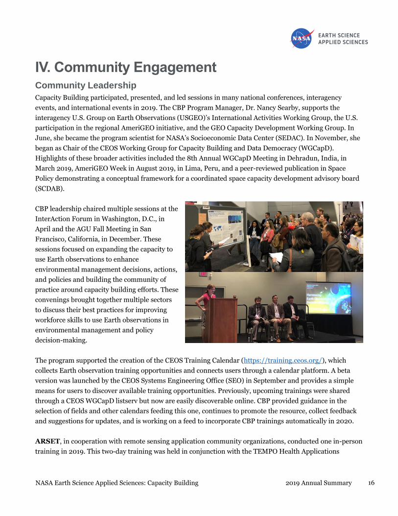
CBP leadership chaired multiple sessions at the
InterAction Forum in Washington, D.C., in
April and the AGU Fall Meeting in San
Francisco, California, in December. These
sessions focused on expanding the capacity to
use Earth observations to enhance
environmental management decisions, actions,
and policies and building the community of
practice around capacity building efforts. These
convenings brought together multiple sectors
to discuss their best practices for improving
workforce skills to use Earth observations in
environmental management and policy
decision-making.
The program supported the creation of the CEOS Training Calendar (https://training.ceos.org/), which
collects Earth observation training opportunities and connects users through a calendar platform. A beta
version was launched by the CEOS Systems Engineering Office (SEO) in September and provides a simple
means for users to discover available training opportunities. Previously, upcoming trainings were shared
through a CEOS WGCapD listserv but now are easily discoverable online. CBP provided guidance in the
selection of fields and other calendars feeding this one, continues to promote the resource, collect feedback
and suggestions for updates, and is working on a feed to incorporate CBP trainings automatically in 2020.
ARSET, in cooperation with remote sensing application community organizations, conducted one in-person
training in 2019. This two-day training was held in conjunction with the TEMPO Health Applications

17 NASA Earth Science Applied Sciences: Capacity Building 2019 Annual Summary
Conference: New Applications in the Use of Satellite Data Monitoring for Population Health. With
community and stakeholder interests in mind, ARSET co-produced tailored agendas to provide attendees
with the skills required to apply Earth observations to decision-making activities. Lectures and exercises
highlighted applications related to air-quality monitoring, forecasting, smoke, fire, PM2.5 monitoring, image
interpretation, and data access for modeling efforts.
DEVELOP led and joined the science and policy communities in a variety of activities in 2019. The program
chaired sessions at the American Association of Geographers Annual Meeting, U.S. International Association
for Landscape Ecology (US-IALE), Pecora 21/ISRSE-38, and co-
chaired a session at the 2019 AGU Fall Meeting. DEVELOP
engaged policy makers through informative visits to state
legislators and participation in Virginia’s Aerospace Day in
Richmond, Virginia, in February and at NASA Day at the
Alabama State Capitol in April. For the second time, DEVELOP
attended Groundwork USA’s Youth Summit and National
Assembly, presenting on the recent collaborations, continuing
engagement with local trusts across the U.S.
SERVIR’s SCO continued to promote and strengthen ongoing engagements with regional initiatives such as
AfriGEO and AmeriGEO. In conjunction with the West Africa and Eastern & Southern Africa Hubs, the SCO
participated in the RCMRD International Conference (RIC) & 4th AfriGEO Symposium in Nairobi, Kenya,
August 13–16. Several hundred attendees participated in the conference events, and RCMRD Director
General Dr. Emmanuel Nkurunziza expressed gratitude to the U.S. Government, particularly USAID and
NASA, for their 10-year partnership with RCMRD through the SERVIR program. Members of the SCO and
the SERVIR-Amazonia hub participated in the AmeriGEO Week Symposium in Lima, Peru, August 19–23,
with SERVIR-Amazonia Project Director Carlos Gasco giving a presentation about the new hub. Dan Irwin
gave a GEO Plenary Intervention at the GEO Ministerial Summit, part of GEO Week events in Canberra,
Australia, November 4–9. He represented the U.S. Delegation in giving plenary remarks to over 100
countries about the value of SERVIR regional hubs in support of GEO.
Representatives from the SERVIR-Mekong hub
presented at the 16th Annual Meeting of the
Asia Oceania Geosciences Society (AOGS 2019)
in Singapore, July 29 – August 2, while 13
participants from across the SERVIR global
network attended Google’s Geo for Good (G4G)
event, held September 16–19 in Sunnyvale,
Calif. G4G brought together Earth Engine and
Earth Outreach users for panels,

18 NASA Earth Science Applied Sciences: Capacity Building 2019 Annual Summary
demonstrations, impact stories, and a “Build-A-Thon.” Kabir
Uddin and Sudip Pradhan, representing ICIMOD/SERVIR-
HKH and working on improving crop layers in the Nepal
National Land Cover Monitoring System (NLCMS), received
the Best User Interface Award during the Build-a-thon.
Members of the SERVIR SCO introduced SERVIR to members
of the scientific community participating in the 70th
International Astronautical Congress in Washington, D.C.,
21–25 October 2019 and Pecora 21/ISRSE-38, and SERVIR’s
global activities were once again well-represented at the AGU
2019 Fall Meeting, held in San Francisco, California (December 9–12). In addition, Dan Irwin presented the
keynote address at the first Africa Geospatial Data and Internet Conference (AGDIC), held in Accra, Ghana,
October 21–25. SERVIR-West Africa hosted their Cloud Computing and Big Data Forum in conjunction with
the AGDIC event.
The Indigenous Peoples Pilot supported multiple efforts to increase indigenous representation at
national and international meetings focused on Earth systems, including at the GEO Week Ministerial
Summit. The IP team also engaged with the indigenous community through conference sessions focused on
collaborations between sovereign tribal nations, federal agencies, and academics, which allows for better
understanding of the value of indigenous knowledge to understanding our complex Earth system. Themes of
the National Adaption Forum (NAF) (Madison, Wisconsin, April 25, 2019), the Society for Conservation GIS
Workshop (Pacific Grove, California, July 15–17), and the Tribal Leaders Summit (Bismarck, North Dakota,
September 5), centered around connecting multiple paths of knowledge, the role of indigenous satellite-
based projects at NASA, and finding indigenous leaders to engage with for future efforts.
Enhancing Data Accessibility
To increase the capabilities of individuals and institutions to use and apply NASA Earth observations, CBP
continues efforts to improve data discovery, access, and management through working with WGCapD to
build awareness of new datasets and future data architectures and with NASA’s SEDAC on needed
population and infrastructure data sets.
ARSET helps training attendees build skills to acquire and use Earth observations for decision support.
Through its capacity-building activities, ARSET facilitated access to satellite data hosted by NASA and other
organizations, including the NOAA, the U.S. Department of Agriculture (USDA), USFS, and non-profit
organizations. The program is also deeply engaged with multiple NASA data centers, serving as a formal
member on two user working groups, GES DISC, and LANCE. These relationships allow ARSET to share the
perspectives and needs of the end-user community with NASA data centers.

19 NASA Earth Science Applied Sciences: Capacity Building 2019 Annual Summary
DEVELOP continued efforts to expand access to tools and results created by its feasibility projects through
its publicly available GitHub portal of data processing tools. In 2019, the program had NASA’s Software
Release Authority approve the release of two tools for public dissemination. Thirty-two projects used Google
Earth Engine (57% of total projects) to harness cloud computing for running analyses, simplify data
processing for project partners, and increase the utility of DEVELOP products. The LPDAAC conducted two
webinars for DEVELOP participants to introduce them to the tools and products made available by the data
center.
SERVIR and its network are highly involved in enhancing data accessibility in the developing world.
SERVIR participated in quality assessment of the very high-resolution data from a commercial vendor under
the NASA Data Augmentation plan. SERVIR SCO evaluated the Planet imagery for its radiometric and
positional accuracies over West Africa. The data were further used to map out small ephemeral water bodies
in West Africa, which was challenging earlier due to moderate spatial resolution data from Landsat and
others.
SERVIR SCO continues to have a critical role in the development and continuous improvement of the Collect
Earth Online (CEO) application that UN-FAO, USFS, SERVIR, and many other organizations throughout the
globe are using to collect expert-interpreted land use/land cover samples using medium- to high-resolution
Earth observation data. SERVIR’s project was one of many that led to the open provision of the purchased
high-resolution data; for more information visit: https://earthdata.nasa.gov/esds/small-satellite-data-buy-
program/commercial-datasets.
The SOCRATES compute cluster has become an extremely important platform for development and
prototyping of SERVIR services, particularly those requiring computing resources exceeding the current
capacity of the regional hubs or the hubs’ partners. HIWAT was run for Hindu-Kush Himalaya for the
second consecutive year successfully and the outputs are being evaluated prior to deployment on
stakeholder-owned infrastructure. SOCRATES is also used for running hydrological models and agricultural
forecasts for Eastern and Southern Africa, and a visualization application (RHEAS Viewer) has been built to
provide farmers with easy to use information derived from these sources.
For the Mekong region, the SCO is co-developing with ADPC an Air Quality Viewer application that
incorporates information from multiple sources that will inform a diverse community of users (ranging from
government organizations to individuals) about historical trends, real time observations, and machine-
learning-based forecasts.
In-person training activities conducted by the Indigenous Peoples Pilot project have enhanced data
access and use among tribal communities. The IP team trainings have continued to provide overviews of
remote sensing, but have focused on highlighting user-friendly online tools that use NASA data in
management decisions. The Satellite-based Drought Reporting on the Navajo Nation Training Workshop

20 NASA Earth Science Applied Sciences: Capacity Building 2019 Annual Summary
(April 9–10, 2019, Flagstaff, Arizona), held in partnership with a Western Water Applications Office
(WWAO) project, provided hands-on exercises for the use of Landsat, MODIS, and VIIRS data for land cover
mapping and vegetation health, along with beta testing of the Drought Severity Evaluation Tool, a Google
Earth Engine application tailored specifically to generate drought severity maps on the Navajo Nation. The
IP team also provided a “NASA Tools and Resources for Disasters” webinar, in collaboration with the AppSci
Disasters Program, that highlighted multiple NASA Earth observation satellites and tools, such as the NASA
Disasters Mapping Portal. This training was provided to members of the Institute of Tribal Environmental
Professionals (ITEP) and to tribal liaisons from other regional and federal agencies.

21 NASA Earth Science Applied Sciences: Capacity Building 2019 Annual Summary
2019 PORTFOLIO

22 NASA Earth Science Applied Sciences: Capacity Building 2019 Annual Summary
V. 2019 CBP Portfolio The Capacity Building Program engages individuals and institutions through a variety of methods for
building capacity to use Earth observations: trainings, feasibility studies, and projects. In 2019, the program
conducted 163 trainings, 56 feasibility studies, and 71 projects. More information about individual projects
and trainings can be found on ARSET, DEVELOP, and SERVIR websites.
CBP activities addressed eight thematic topics in alignment with the Applied Sciences’ Application Areas:
Agriculture & Food Security, Disasters, Ecological Forecasting, Energy, Health & Air Quality, Transportation
& Infrastructure, Urban Development, and Water Resources, as well as other cross-cutting topics such as
remote sensing and GIS fundamentals, climate, and weather applications.
Thematic Focus Areas of the Capacity Building Activities
Application Areas Training Portfolio Project Portfolio
Agriculture & Food Security 14% (23 trainings) 20% (26 projects)
Disasters 11% (18 trainings) 7% (9 projects)
Ecological Forecasting 29% (47 trainings) 25% (32 projects)
Energy 0% (0 trainings) 2% (3 projects)
Health & Air Quality 5% (8 trainings) 2% (3 projects)
Transportation & Infrastructure 0% (0 trainings) 2% (2 projects)
Urban Development 0% (0 trainings) 6% (8 projects)
Water Resources 9% (14 trainings) 28% (36 projects)
Cross-cutting / Other 33% (53 trainings) 7% (9 projects)

23 NASA Earth Science Applied Sciences: Capacity Building 2019 Annual Summary
GEOGRAPHIC REACH

24 NASA Earth Science Applied Sciences: Capacity Building 2019 Annual Summary
VI. Geographic Reach Geographic Extent of Activities
The Capacity Building Program actively participated in U.S. and international Earth observations and
capacity-building activities in 2019 through USGEO, GEO, CEOS, and program element activities.
Combined CBP Reach
Black denotes the 158 countries reached by CBP activities; gray denotes countries not impacted.
Element Reach
Each element has different geographical targets and focus. Through its online and in-person trainings,
ARSET has a global reach, with approximately 18% of the training participants from the U.S. and 82% from
outside the U.S. DEVELOP’s primary focus is domestic capacity building, and in 2019 the project portfolio
consisted of 71% of projects addressing domestic issues and 93% of participants were U.S. citizens. SERVIR
is inherently international, working in partnership with leading regional organizations around the globe to
help developing countries use information provided by Earth observing satellites and geospatial technologies
for managing environmental risks and land use, but also engages domestically through its AST.

25 NASA Earth Science Applied Sciences: Capacity Building 2019 Annual Summary
ARSET online and in-person
trainings reached participants in 151
countries and all 50 U.S. states.
Black denotes the 151 countries impacted by ARSET
DEVELOP reached 48 U.S. states
and 29 countries through its projects
and participants.
Black denotes the 29 countries impacted by DEVELOP
SERVIR engaged in 52 countries and
21 U.S. states through its SCO,
regional hubs, and AST.
Black denotes the 52 countries impacted by SERVIR

26 NASA Earth Science Applied Sciences: Capacity Building 2019 Annual Summary
Regional Reach
CBP organizes international activities by GEO Regional Caucus (Americas, Asia & Oceania, Europe, Africa,
and CIS) to assess progress and identify regions that have benefited most from the Program’s capacity
building. For each region, overall reach is summarized, and additional information from AST projects is
included.
Americas
CBP reached 7,098 individuals in 29 countries in the Americas caucus region through:
ARSET – 6,619 individuals (trainees) through one in-person and 16 online trainings
DEVELOP – 254 individuals (project participants) through 40 feasibility studies (projects with study
area in region) and six trainings
SERVIR – 190 individuals through 11 in-person trainings, and three workshops
Indigenous Peoples – 35 individuals through three in-person trainings
Black denotes the 29 countries in the Americas impacted by CBP
Asia & Oceania
CBP reached 3,218 individuals in 39 countries in the Asia & Oceania caucus region through:
ARSET – 2,422 individuals through 15 online trainings
DEVELOP – 11 individuals (project participants) through two feasibility studies (projects with study
area in region)
SERVIR – 785 individuals and eight multi-year projects, 43 in-person trainings, and 25 workshops

27 NASA Earth Science Applied Sciences: Capacity Building 2019 Annual Summary
Black denotes the 39 countries in Asia & Oceania impacted by CBP
More information for the multi-year projects:
Monitoring and Forecasting Drought and Crop Yield for the Lower Mekong Basin (ROSES 2015 -
SERVIR AST)
Principal Investigator: Konstantinos Andreadis, NASA Jet Propulsion Laboratory (former PI was Stephanie
Granger)
AppSci Application Area: Agriculture | Thematic Service Area: Agriculture and Food Security
Description: This project used NASA data, local ground observations, and forecasts in a modeling system to
provide hydrologic data and drought assessments with associated agricultural yield for the Lower Mekong Basin.
The drought-monitoring component of this project contributes significantly toward hub services related to the
Agriculture Service Area. Konstantinos Andreadis and Narendra Das conducted technical meetings on the
Regional Drought & Crop Yield Information System with co-development partners and stakeholders in Hanoi,
Vietnam, on April 25–26, followed by a Hackathon on RHEAS Coding conducted by Das and Amor Ines at ADPC
in Bangkok, Thailand, from April 29 – May 3rd. RHEAS was implemented and is operational at ADPC, for
drought and rice yield nowcast and seasonal forecast, at https://rdcyis-servir.adpc.net. Goal ARL of 8 was
achieved for this project, which completed on July 31, 2019.
Improved Hydrologic Decision Support for the Lower Mekong River Basin through Integrated
Remote Sensing and Modeling (ROSES 2015 - SERVIR AST)
Principal Investigator: John Bolten, NASA Goddard Space Flight Center
AppSci Application Area: Water Resources | Thematic Service Area: Water Resources & Hydroclimatic Disasters
Description: This project aimed to complement and improve ADPC/SERVIR-Mekong’s hydrological modeling
capabilities and access to state-of-the-art Earth observation satellite data to enhance water resource management
decision-making, agricultural monitoring and forecasting capabilities. Leveraging a previous NASA Disasters
Program project, an operational flood inundation and socio-economic impact system was transitioned and began
testing, running on ADPC’s server in 2018. A training on the Advanced Soil and Water Assessment Tool (SWAT-
CUP) and Soil Moisture Downscaling was held at ADPC in November 2018, followed by a seminar/training on
Observing the Terrestrial Water Cycle from Space, provided by Dr. Venkat Lakshmi at ADPC on October 21, 2019.

28 NASA Earth Science Applied Sciences: Capacity Building 2019 Annual Summary
PI Bolten attended the SWAT-SEA conference Oct. 21–26 in Siem Reap, Cambodia, presenting a keynote on
‘Mapping the Blue Marble: Using Space-Based Observations for Improved Global Water Security and
Sustainability,’ and a joint AST-Hub-SCO publication on SWATOnline and NASAaccess was published in October
2019, in Environmental Modelling & Software, and a joint AST-Hub-SCO publication on SWATOnline and
NASAccess was published in October 2019 in Environmental Modelling & Software. Goal ARL of 8 was achieved
for this project, which was completed on June 30, 2019.
Managing the Changing Water Resources South of the Himalayas (ROSES 2015 - SERVIR AST)
Principal Investigator: Cédric David, NASA Jet Propulsion Laboratory
AppSci Application Area: Water Resources | Thematic Service Area: Water Resources & Hydroclimatic Disasters
Description: This project trains regional stakeholders and local water managers in the Hindu Kush Himalaya
Region to combine remotely-sensed data from GRACE, MODIS, and AMSR2 with NASA modeling assets (GLDAS
and RAPID) to provide actionable information on water resources and water-related disasters (floods and
droughts), focusing on historical conditions and near real time estimates. The project held a Training of Trainers
on “Estimation of Groundwater Storage Changes Using GRACE Satellites” at ICIMOD in Kathmandu, Nepal, April
22–24, 2019. PI David also held a UNESCO/NASA GRACE training in Iguacu Falls, Brazil, June 4–8. The
project’s Satellite Hydrology Bits Analysis And Mapping (SHBAAM) application (using GRACE AND GLDAS), and
Routing Application for Parallel computatIon of Discharge (RAPID) Flow (using GLDAS and RAPID) have
reached an ARL of 6, while the SERVIR-Snow application (using MODIS and AMSR) reached its goal ARL of 5.
RAPID is now running at ICIMOD. Current overall ARL for this ongoing project is 6, with a no-cost extension
(NCE) through the end of February 2020.
Monitoring Intense Thunderstorms in the Hindu Kush-Himalayan Region (ROSES 2015 - SERVIR
AST)
Principal Investigator: Patrick Gatlin, NASA Marshall Space Flight Center
AppSci Application Area: Weather | Thematic Service Area: Weather and Climate
Description: This project integrated NASA Earth Observing System information to facilitate daily assessments of
the hazards posed by thunderstorms in the Hindu-Kush Himalayan region. High Impact Weather Assessment
Toolkit (HIWAT) components correctly depicted the fatal and damaging hail event in Bangladesh on March 30,
2018. During 2018, the project completed the major milestone of a spring forecast demonstration with the
Toolkit. HIWAT weather forecasts were used by the Department of Hydrology and Meteorology (DHM)-Nepal in
their decision-making process during the pre-monsoon and monsoon season for that year, and the project reached
its goal ARL of 7. HIWAT successfully demonstrated the feasibility of enhancing weather forecasting services, in
particular for high-impact weather hazards in the HKH region, and is being expanded for use in other SERVIR
regions susceptible to extreme weather. PI Gatlin held a HIWAT Transitional Training for the ICIMOD GIT team
from April 8–12, 2019, as well as an ‘Extreme Weather Warning Using HIWAT’ Training to the Bangladesh
Meteorological Department on April 10–11. As part of a related Subject Matter Expert (SME) activity from
October 28–29, PI Gatlin held a Technical Meeting on Supporting Developing HIWAT for SERVIR-Mekong, at
ADPC in Bangkok, Thailand. HIWAT is running at ICIMOD at https://tethys.servirglobal.net/apps/hiwat/. The
project was completed on October 31, 2019.
Building Lasting Capacity for Water Management in Vulnerable Deltas of Indochina (ROSES 2015
- SERVIR AST)
Principal Investigator: Hyongki Lee, University of Houston
AppSci Application Area: Water Resources | Thematic Service Area: Water Resources & Hydroclimatic Disasters

29 NASA Earth Science Applied Sciences: Capacity Building 2019 Annual Summary
Description: This project aimed to develop a comprehensive, satellite data-based system that can routinely map,
provide early warning of, and enable decision-making on water-related vulnerability issues in low-lying deltas of
Indochina. A seasonal water availability anomaly forecasting prototype with the Soil & Water Assessment Tool
(SWAT) was developed during 2018. A training was provided to SERVIR-Mekong on June 3, 2019, followed by a
training and ‘Technical Meeting on Supporting Flood Forecasting and Water Resource Management Services for
the Viet Nam Meteorological and Hydrological Administration (VNMHA)’ on June 4. VIC-added altimetry-based
daily river level forecasting for the Mekong was developed, particularly for downstream regions of Tonle Sap Lake
and the Mekong Delta, and an operational virtual gauging system using Jason-2/3 altimetry was adopted by
SERVIR-Mekong (https://vrsg-server.adpc.net) for regional applications and made available for global
applications at https://tethys.servirglobal.net/apps/altex. An operational dam monitoring and outflow prediction
system is now in service with NAWAPI of Vietnam (http://forecasting.vaci.org.vn). This project reached a final
ARL of 6 and was completed on July 31, 2019.
Comprehensive Stream Flow Prediction and Visualization to Support Integrated Water
Management (ROSES 2015 - SERVIR AST)
Principal Investigator: Jim Nelson, Brigham Young University
AppSci Application Area: Water Resources | Thematic Service Areas: Water Resources & Hydroclimatic Disasters
Description: This project developed a cloud-based water resources applications portal and specific web
applications to empower the International Centre for Integrated Mountain Development to help water resource
managers and other decision-makers in the Hindu Kush Himalaya region access and use streamflow forecasts,
flood mapping, and data. Access to these tools and information is enabling preparation for and public warnings of
impending floods and related disasters, promoting resilience and recovery after flood events. Tools including
HIWAT, GRACE, SALDAS Forecast Visualizer, Streamflow Prediction Tool (for Nepal and Bangladesh), Regional
Drought Monitoring System (beta), Agricultural Drought Watch, and HydroViewer Nepal are now available
through the SERVIR-HKH, SERVIR-Mekong, and SCO Tethys Apps, with hydroinformatics support provided for
all four Applied Science Team (AST) projects for HKH. PI Nelson joined AST PI Ben Zaitchik at the ICIMOD-
SERVIR Training Workshop on AST Forecasting Tools in Kathmandu, Nepal, May 13–14, 2019. Current ARL is 8
for this project, with a NCE through January 31, 2020.
Supporting satellite-based national land-cover and land-use change monitoring systems in South-
East Asian countries (Burma, Cambodia, Laos, Thailand, and Vietnam) (ROSES 2015 - SERVIR
AST)
Principal Investigator: Peter Potapov, University of Maryland, College Park
AppSci Application Area: Ecological Forecasting | Thematic Service Area: Land Cover and Land Use Change &
Ecosystems
Description: This tool employed annual Landsat time-series data to create regionally consistent annual tree
canopy cover and height layers at 98-ft. (30m) spatial resolution for Southeast Asian Countries. The provided data
and data analysis tools were designed to help develop regionally consistent annual forest extent and change maps
and implement monitoring results in national and regional planning and management. The data layers are key
contributors to SERVIR-Mekong’s Regional Land Cover Monitoring System (RLCMS). During 2019, the project
completed development of a semi-automatic, operational algorithm for mapping and monitoring of woody
vegetation canopy cover and height at a regional scale using Landsat ARD time-series. The 2000–2018 time-
series of regional products were integrated into RLCMS and provided as a service to regional stakeholders through
a dedicated data portal, and capacity has been transferred over to SERVIR-Mekong. A training on ‘Implementing
the Global Land Cover and Analysis (GLAD) System for monitoring forest cover change in Cambodia’ was held in

30 NASA Earth Science Applied Sciences: Capacity Building 2019 Annual Summary
Phnom Penh from April 22 – May 3, 2019, and an ‘Overview of SERVIR RLCMS and GLAD systems
implementation for national forest monitoring in Myanmar’ training was held in Nay Pyi Taw, Myanmar, July 2–
3. This project reached a final ARL of 8, and was completed July 17, 2019.
Seasonal Prediction of HKH Hydrological Extremes with the South Asia Land Data Assimilation
System (ROSES 2015 - SERVIR AST)
Principal Investigator: Benjamin Zaitchik, Johns Hopkins University
AppSci Application Area: Climate | Thematic Service Area: Weather and Climate
Description: This project generates sub-seasonal to seasonal (S2S) hydrological forecasts for the Hindu Kush
Himalaya region, working with end users to produce forecast products that describe the risk of drought or floods
on time horizons of weeks to months. This project is helping the SERVIR-Hindu Kush Himalaya Hub with better
compilation of different data layers to analyze regional drought. The South Asia LDAS Subseasonal to Seasonal
Forecast System (SALDAS) now includes preprocessing scripts to automate bias correction and downscale GEOS-
S2S seasonal forecasts using the NCAR GARD tool, and forecast capabilities have been transferred to ICIMOD. PI
Zaitchik joined AST PI Jim Nelson at the ICIMOD-SERVIR Training Workshop on AST Forecasting Tools in
Kathmandu, Nepal, May 13–14, 2019. The 2019 monsoon season hydrological forecasts were presented to end
users during the workshop, and are served through ICIMOD’s portal, and SALDAS has been integrated into
ICIMOD’s Agricultural Drought Watch. The goal ARL of 8 was achieved for this project, with a NCE through July
17, 2020.
Africa
CBP reached 1,842 individuals in 44 countries in the Africa caucus region through:
ARSET– 1,265 individuals through 15 online trainings
DEVELOP – Three individuals (project participants) through one feasibility study (project with
study area in region)
SERVIR – 574 individuals and eight multi-year projects, 28 in-person trainings and eight workshops
Black denotes the 44 countries in Africa impacted by CBP

31 NASA Earth Science Applied Sciences: Capacity Building 2019 Annual Summary
More information for the multi-year projects:
Supporting National Agricultural Monitoring for Food Security (ROSES 2015 - SERVIR AST)
Principal Investigator: Inbal Becker-Reshef, University of Maryland, College Park
AppSci Application Area: Agriculture | Thematic Service Area: Agriculture and Food Security
Description: This project builds capacity and develops remote-sensing, smart-phone, and collaborative internet
technologies for the collection, analysis, and dissemination of data on the status of agricultural and crop
conditions as a basis for decision-making, policy design, and agricultural development interventions in Eastern
and Southern Africa. A joint UCSB-UMD Hydro-agrometeorology Training was led by Becker-Reshef and AST PI
Shrad Shukla (University of California, Santa Barbara), February 27 – March 1 in Dar es Salaam, Tanzania; and a
National Crop Monitor Training was led by Becker-Reshef and RCMRD staff in Kigali, Rwanda, March 4–8. Data
from this project continues to serve as inputs to Intergovernmental Authority on Development (IGAD) Climate
Prediction and Application Centre’s (ICPAC’s) Eastern Africa Crop Monitor report, delivered quarterly, as well as
to the Kenya National Crop Monitor report, the National Crop Monitor Report for Uganda, and National Crop
Monitor Report for Tanzania, each delivered monthly. A GIS-based sampling frame was developed and enabled
the Kenyan Crop Insurance program to expand coverage across the country. This project reached a final ARL of 8
(exceeding the goal ARL of 7) and was completed on August 1, 2019.
A West Africa LDAS for Forecasting Extreme Hydrological Events (WALFEHE) (ROSES 2015 -
SERVIR AST)
Principal Investigator: Augusto Getirana, NASA Goddard Space Flight Center
AppSci Application Area: Climate | Thematic Service Area: Water Resources and Hydroclimatic Disasters
Description: This project provides an improved land data assimilation system (LDAS) for integrated water
management by Agriculture, Hydrology and Meteorology (AGRHYMET) Regional Center member nations, with a
focus on hydrological modeling to provide meteorological, hydrological, and agricultural drought
characterizations and forecasts, as well as flood modeling and forecasting. During 2019, Land surface Data Toolkit
(LDT) and Land Information System (LIS) libraries were successfully implemented on SERVIR’s SOCRATES
server, capacity was transferred over to the hub, and AGRHYMET acquired a server (at their own cost) to install
LIS to have it run operationally. The West Africa LIS Viewer was installed and is now running at AGRHYMET.
The West Africa LDAS is fully based on the NASA’s LIS, using state-of-the-art models, data assimilation schemes,
and datasets for integrated water management in West Africa. Current ARL is 5 for this ongoing project, with a
NCE through August 1, 2020.
Desertification or "re-greening"? Adaptation lessons learned in coping with late 20th century
drought in West Africa (ROSES 2015 - SERVIR AST)
Principal Investigators: Alessandra Giannini, International Research Institute for Climate and Society (IRI),
Columbia University – transitioned in April 2019 to Christopher Small, Lamont-Doherty Earth Observatory,
Columbia University
AppSci Application Area: Climate | Thematic Service Area: Weather and Climate
Description: This project uses information from Earth observations and model simulations to develop climate
information for decision-making in natural resources management, including water and landscapes, to improve
understanding of historical trends in the character of precipitation, their relation to oceanic influence, and to
expectation from warming, and to improve agriculture and food security outcomes in West Africa. The project’s
main results were shared at the SERVIR AST showcase event at NASA headquarters in June 2019. A paper

32 NASA Earth Science Applied Sciences: Capacity Building 2019 Annual Summary
(Giannini & Kaplan, 2019) was published in Climatic Change, and research regarding the prediction of Sahelian
rainfall was prepared for publication, as well as presented at the 2019 AGU fall meeting. Current ARL is 6 for this
ongoing project, with a NCE through July 17, 2020.
Supporting Pastoralist Livelihoods in West Africa Through Remote Sensing of Rangeland
Vegetation Structure, Forage Production and Long-Term Trend Analysis (ROSES 2015 - SERVIR
AST)
Principal Investigator: Niall Hanan, New Mexico State University
AppSci Application Area: Agriculture | Thematic Service Area: Agriculture and Food Security
Description: This project assists SERVIR-West Africa in developing remote sensing-based applications relevant to
rangeland vegetation structure and forage production to improve the well-being and resilience of pastoralist and
agropastoralist communities in West Africa. This project collaborates with West Africa Consortium partner CSE
(based in Senegal), to improve rangeland monitoring in West Africa. CSE has been using the tools developed
under this project (in GEE), and these tools will be integrated into the ephemeral water body monitoring service at
CSE. Current ARL for this ongoing project is 7, with a goal ARL of 8 and an award end date of July 11, 2020.
Enabling Local Monitoring of Landscape Change Across Eastern Africa (ROSES 2015 - SERVIR
AST)
Principal Investigator: Sean Healey, U.S. Forest Service, Rocky Mountain Research Station
AppSci Application Area: Ecological Forecasting | Thematic Service Area: Land Cover and Land Use Change and
Ecosystems
Description: This project enabled SERVIR-Eastern and Southern Africa/RCMRD to use cloud computing and the
Landsat archive to deliver historical and continuously updated 98-ft. (30m) land cover maps across seven
countries (Kenya, Malawi, Ethiopia, Zambia, Tanzania, Rwanda, and Uganda). This project built the capacity of
the SERVIR hub to become the regional leader in Land Cover Monitoring, and is providing key annual updates to
member countries. Annual Land Cover Change Maps are now operational, with the TimeSync tool used to
visualize the Landsat archive. The project worked in collaboration with Spatial Informatics Group (SIG), and
integration of the TimeSync tool with Collect Earth Online is nearly complete. This project reached a final ARL of
8 (exceeding the goal ARL of 7) and was completed on August 3, 2019.
Forecasting and Communicating Water-Related Disasters in Africa (ROSES 2015 - SERVIR AST)
Principal Investigator: Yang Hong, University of Oklahoma, Norman
AppSci Application Area: Disasters | Thematic Service Area: Water Resources and Hydroclimatic Disasters
Description: This project uses the EF5 (the Ensemble Framework for Flash Flood Forecasting) hydrologic model
to enhance decision-making for water and water-related disasters in Eastern and Southern Africa. Capacity has
been strengthened at RCMRD and with stakeholders to use EF5 for flood monitoring and forecasting in the
region. Advanced EF5 Training for Kenya was held at RCMRD on November 18–19, 2019, followed by an
Advanced EF5 Training for Uganda (November 21–22, in Kampala, Uganda). Current ARL is 7 for this ongoing
project, with a NCE through April 17, 2020.
Enhancing Eastern and Southern Africa Climate Services by Increasing Access to Remote Sensing
and Model Datasets (ROSES 2015 - SERVIR AST)
Principal investigator: Shraddhanand Shukla, University of California, Santa Barbara
AppSci Application Area: Agriculture, Climate | Thematic Service Area: Agriculture and Food Security

33 NASA Earth Science Applied Sciences: Capacity Building 2019 Annual Summary
Description: This project enhances SERVIR-Eastern and Southern Africa/RCMRD’s access to NASA and Famine
Early Warning System Network (FEWS NET) Earth observations, datasets, models, forecasts, and web services to
support agricultural and water resources decision-making by ministries and organizations in the region. The Early
Warning Explorer (EWX) products, created as part of this project, are being used in several hub services, such as
climate vulnerability assessments, and EWX has been fully transitioned to SERVIR-E&SA/RCMRD. Operational
production of seasonal scale Evaporative Demand Drought Indication (EDDI) forecasts has been occurring since
August 2018, and development and validation of CHIRTSmax was completed. For more information and access to
the forecasts, visit https://chc.ucsb.edu/data. A joint UCSB-UMD Hydro-agrometeorology Training was led by
Becker-Reshef and AST PI Shrad Shukla (University of California, Santa Barbara), February 27 – March 1 in Dar
es Salaam, Tanzania. CHIRPS-GEFS and EWX are now being applied by the Zambia Meteorological Department
(ZMD) for providing weather forecast maps in ZMD’s crop weather bulletin, while the Tanzania Ministry of
Agriculture is using CHIRPS and EWX to support early warning of crop yield and food security in the region. Goal
ARL of 9 was achieved for this project, which completed July 12, 2019.
Monitoring and Projecting Environmental Change in Fragmented Tropical Forest Landscapes
(ROSES 2015 - SERVIR AST)
Principal Investigator: Michael Wimberly, GISc Center of Excellence, South Dakota State University
AppSci Application Area: Ecological Forecasting | Thematic Service Area: Land Cover and Land Use Change and
Ecosystems
Description: This project integrates Landsat data and landscape simulation models to map historical forest
degradation and project future impacts of climate and land-use change on West African forests. This project has
generated annual estimates of forest degradation from 2004–2014 in response to a request from the Forestry
Commission of Ghana (FC). A database of 7,750 training and validation plots interpreted with high-resolution
imagery from 2010–2017 were developed for accuracy assessment, and field assessments were conducted. The
project worked closely with the FC to adapt the West Africa Forest Degradation Dataset (WAForDD) to their
needs. Outputs of v1.0 are being used by the FC for their REDD+ reference emission baseline calculations.
WAForDD v2.0, combining multi-sensor predictions of forest canopy condition with temporal segmentation of
degradation trends using the LandTrendr algorithm in GEE, is now complete. Stakeholders from the FC also
provided feedback on several desired modifications that will be implemented before the end of the project period,
with v2.1 coming soon. Goal ARL of 7 has been reached for this ongoing project, with a NCE through February 7,
2020.

34 NASA Earth Science Applied Sciences: Capacity Building 2019 Annual Summary
Europe
CBP reached 2,168 individuals in 38 countries in the Europe caucus region through:
ARSET – 1,945 individuals through 15 online trainings
DEVELOP – one individual (project participant)
SERVIR – 222 individuals
through two in-person
trainings
Black denotes the 38 countries in Europe impacted by CBP
Commonwealth of Independent States (CIS)
CBP reached 108 individuals in eight countries in the CIS caucus region through:
ARSET – 108 individuals through 15 online trainings
Black denotes the eight countries in CIS impacted by CBP

35 NASA Earth Science Applied Sciences: Capacity Building 2019 Annual Summary
PROGRAM MANAGEMENT

36 NASA Earth Science Applied Sciences: Capacity Building 2019 Annual Summary
VII. Program Management Management Team
Capacity Building is led by Dr. Nancy Searby at NASA Headquarters. In 2019, the program was supported by
Christine Mataya and Lauren Childs-Gleason, who served as liaisons between the Elements and NASA
Headquarters. Each Element was led by management teams at NASA Centers: ARSET – Dr. Ana Prados,
UMD at GSFC; DEVELOP – Michael Ruiz, NASA LaRC; and SERVIR – Dan Irwin, NASA MSFC. The
Indigenous Peoples Initiative is led by Dr. Cindy Schmidt, BAERI at ARC. Betzy Hernandez, UAH at MSFC,
serves as Associate Program Manager for the AmeriGEO and Human Planet project portfolio.
Strategic Planning
The Capacity Building Program continues to grow and strengthen through enhanced communication,
coordination, and collaboration.
In 2019, the program established bi-annual strategic discussions with each of the Applied Sciences’ program
areas’ teams in the areas of Water Resources, Disasters, Agriculture & Food Security, Ecological Forecasting,
and Health & Air Quality. These exchanges allowed for increased coordination through shared discussions
around programmatic activities and user engagement. Joint actions and increased awareness of each others’
efforts have found efficiencies and new opportunities.
Also in 2019, the program facilitated four virtual retreats focused on tactical topics of priority to the
program. Participants focused their discussions on: 1) creation of a GEO & CEOS engagement strategy, 2)
indicators and tracking logistics, 3) streamlining reporting mechanisms, and 4) needs assessments, feedback
collection, and sharing. Outcomes of the retreats were a strategic engagement planning process for activities
related to CEOS and GEO, an updated and finalized set of indicators for the program that were collected in
2019 and are being reported in this document, a shared understanding of the various needs assessments and
opportunities for collecting and sharing feedback, and identification of opportunities to simplify reporting
requirements. Looking ahead to 2020, the program plans to build on these efforts and conduct an in-person
retreat focused on revisiting the framework and re-envisioning our feedback collection and sharing.

37 NASA Earth Science Applied Sciences: Capacity Building 2019 Annual Summary
On August 2, the program participated in a one-
day strategic communications workshop at NASA
Headquarters, which was focused on collecting
inputs from the team to draft strategic goals for
the program’s technical content strategy. This
document will guide and support the program’s
communications efforts and activities for 2020
and into the future.
In addition to programmatic strategic planning, elements also participated in strategic activities at the
element level:
ARSET’s strategic planning relies on feedback from program participants. These data are used by the
program to help determine if program goals are being met and to make adjustments as needed. They
are also used for end-user needs assessments and to determine future training topics. ARSET held an
Annual Team meeting at the University of Maryland, Baltimore County in February 2019. Highlights
included an overview of 2018 program accomplishments and a discussion of what went well and
what did not. Survey results were also discussed in detail because these are always used for future
planning. Results have been consistent over the past few years, with some changes in future topics of
interest such as cloud computing. Future ARSET hires will reflect these changes, so that ARSET can
continue to build skills that are consistent with user demand. The last day featured an interactive
session on communications, including live practice of elevator speeches on what ARSET does and
how NASA data can be used for societal benefit.
DEVELOP hosted two leadership and strategic planning retreats in 2019. The April retreat’s primary
focus was to evaluate the outcomes of the past three-year strategic plan and lay the groundwork for
the next plan. Participants conducted a SWOT analysis, identifying areas of success and areas of
improvement for the program, and brainstorming sessions for new and innovative approaches for
DEVELOP’s consideration. The December retreat focused on refining elements of the draft strategic
plan for completion in early 2020. During both retreats, participants benefited from sessions on
professional development, meetings with NASA leadership, and learning about broader efforts of the
Applied Sciences and Capacity Building programs.
On May 23, 2019, NASA and U.S. Agency for International Development (USAID) officials convened
at NASA Headquarters in Washington, D.C., for the sixth SERVIR Joint Working Group (JWG). The
purpose of the meeting was to discuss progress since the last JWG, provide updates and
accomplishments, and discuss plans moving forward. Support, commitment, and encouragement
was expressed for the SERVIR Project by NASA and USAID leadership, including support for
development of a 2020–2025 SERVIR Strategic Plan. An official NASA memo summarizing the
event was released in June.

38 NASA Earth Science Applied Sciences: Capacity Building 2019 Annual Summary
Indigenous Peoples Pilot Project will primarily focus on establishing and strengthening the GEO
indigenous community of practice. This includes attending tribal-led meetings to listen to
community needs and discuss tools and resources available, collaborating and partnerning with
organizations (government, NGOs, private foundations) to work with indigenous communities, co-
developing training materials for indigenous communities that include participatory mapping
approaches specifically at the Indigenous Mapping Workshop in Regina, Canada, in May, and
continuing to learn from indigenous communities about their needs and best ways to use Earth
observations. We will also focus on increasing the engagement of indigenous peoples in U.S. GEO
and AmeriGEO by co-developing an engagement plan, conducting workshops in U.S. Indian country,
and developing an indigenous session at the AmeriGEO meeting in Mexico in September 2020.
Program Assessment
The program collects outcomes through success stories, highlights, ARSET surveys, and DEVELOP
participant surveys. Indicators are used to track intermediate results. Strategic targets are assessed annually,
along with Application Readiness Level (ARL) and Project Strength Index (PSI) scores to track yearly
progress.
Strategic Targets & Growth
Each element addresses strategic goals and contributes to the objectives through specific targets and
activities. Below shows tracking of targets and actuals over time.
ARSET
Activity Target 2014 2015 2016 2017 2018 2019
U.S. States Impacted 40+ 44 50 50 50 50 50
Countries Impacted 90+ 109 123 130 132 138 151
Total # of Individuals 1,500+ 1,014 2,877 3,277 4,864 6,362 12,370
Total # of Institutions 500+ 650 1,032 1,392 2,030 2,570 4,273
Application Areas 4 4 4 7 4 4 4
Trainings Varies 11 11 15 18 17 16
DEVELOP
Activity Target 2014 2015 2016 2017 2018 2019
U.S. States Impacted 35+ 46 50 42 49 46 48
U.S.: International <1:4 N/A 1:4 1:4 1:6 1:5 2:7
Total # of Individuals 250+ 379 393 359 342 308 269
Total # of Institutions 75+ 160 157 125 128 121 135
Application Areas All All (9/9) All (9/9) 8/9 All (9/9) All (8/8) All (8/8)
Feasibility Studies 60 83 93 77 70 65 56
SERVIR

39 NASA Earth Science Applied Sciences: Capacity Building 2019 Annual Summary
Activity Target 2014 2015 2016 2017 2018 2019
Countries Impacted 38 44 43 40 40 41 52
Custom Services 42 N/A 47 38 37 42 36
Total # of PI Leads 16 N/A 11 27 25 16 36
Total # of Individuals 283 425 834 623 1202 1,907 1,771
Total # of Institutions 27 159 128 143 150 249 195
Indigenous Peoples Pilot
Activity 2017 2018 2019
US States Impacted 9 3 7
Total # of Participants 39 23 35
Total # of Organizations 19 12 11
Application Areas Covered 3 2 3
Indicator Tracking
The programmatic performance tracking system was initiated in 2016 based on results frameworks that
identify unique indicators for each program element, with a refined number of program-wide indicators
collected across all elements. The collection process and indicators collected were refined at the end of 2018
with enhanced definitions of inputs feeding each indicator from each element and a new submission system
and documentation. 2019 provided the first full year with the refined indicators, where inputs were collected
on a quarterly basis.
2019 Aggregated Indicators: IR-1: Improved Awareness of – and Access to – Earth Observation Data, Products, and Tools Sub-IR 1.1: Awareness Increased in New Geographic Regions & Different Sectors
1.1.1 The Number of States & Countries Reached through CBP Trainings & Projects
50 states; 158 countries
1.1.2 The number of Institutions (by type) Reached through Trainings & Projects
Total: 4,556 – Academic Institution (38%); Consortium (<1%); Federal/ Central Government (19%); Intergovernmental Organization (2%); Local
Government (3%); Private Sector (For-Profit) (16%); Private Sector (Non-Profit)/Voluntary or NGO (13%);
Research Institute (<1%); State/ Provincial Government (5%); Tribal Entity (1%)
Sub-IR 1.2: Individual & Institution Needs Identified
1.2.1 The number of front end engagement activities 35,944
Sub IR-1.3: Access to Data, Products, Tools & Trainings Enhanced
1.3.1 The number of CBP trainings & projects by AppSci National Application Area
Projects – 127 Total: Agriculture (26); Disasters (8); Ecological Forecasting (32); Energy (3); Health & Air Quality (3); Transportation & Infrastructure (2); Urban
Development (8); Water Resources (36) Trainings – 163 Total: Agriculture (23); Disasters (18); Ecological Forecasting (47); Energy (0); Health & Air Quality (8); Transportation & Infrastructure (0); Urban
Development (0); Water Resources (14)
1.3.2 The number of CBP products posted online 384

40 NASA Earth Science Applied Sciences: Capacity Building 2019 Annual Summary
1.3.3 The number of NASA Earth observation platforms & sensors utilized in projects & highlighted in trainings
57
IR-2: Strengthened Capacity to Use Earth Observation Data, Products & Tools Sub-IR 2.1: Individuals Engaged & Trainings Delivered
2.1.1 The number of trainings & workshops given or facilitated by CBP Elements
163
2.1.2 The number of individuals engaged in CBP activities
14,445
2.1.3 The number of policy & science conferences attended
101
Sub-IR 2.2: Tailored Products & Tools Co-developed
2.2.1 The number of products developed by/with support from CBP
478
Sub-IR 2.3: Number of Organizations Using NASA Earth Observations in Their Decision-Making Process
2.3.1 The number of individuals and/or institutions integrating Earth observations in their decision-making process
40
IR-3: Improved Capacity Building Practices & feedback to Earth Science Community
Sub-IR 3.1: Best Practices & Lessons Learned Collected & Shared
3.1.1 The number of best practice documents produced and/or presented by CBP
3
3.1.2 The number of outreach events for CBP activities 24
Sub-IR 3.2: Increased Capability to Monitor & Evaluate Impact of CBP Activities and Collect Feedback
3.2.1 The percent of individuals who completed pre-training/project surveys & assessments
ARSET (100%); DEVELOP (Participants – 99%; Partners – 50%) SERVIR (N/A); IP (N/A)
3.2.2 The percent of individuals who completed post-training/project surveys & assessments
ARSET (33%); DEVELOP (Partners – 22%; Participants – 97%); SERVIR (N/A); IP (N/A)
3.2.3 The number of projects that achieved yearly ARL goal
8 out of 16
3.2.4 The annual average PSI score for feasibility projects
3.1
Sub-IR 3.3: Feedback to Earth Science Community Delivered
3.3.1 The number of participation in Science Team Meetings
6
3.3.2 The number of DAAC engagement and feedback activities
7
Project Process Tracking
Capacity Building tracks projects through two measurements: SERVIR AST’s long-term projects are tracked
using the Application Readiness Level (ARL) scale, which begins at 1 (basic research) and continues to a 9
(sustained use of tool); and DEVELOP feasibility projects are tracked using the Project Strength Index (PSI).
Metrics for Multi-Year Projects in 2019: Metric ROSES 2015 Projects SERVIR AST ARL Range 5 - 9
SERVIR AST ARL Mean 7.2
SERVIR AST ARL Mode 8
# of Projects with ARL 1-3: 0
# of Projects with ARL 4-6: 5
# of Projects with ARL 7-9: 11
% of Projects Advanced 1+ ARL in past 12 months 68.7% (11 of 16)

41 NASA Earth Science Applied Sciences: Capacity Building 2019 Annual Summary
In terms of performance, out of the 2015 AST projects, 11 of 16 projects advanced one or more ARLs. Six
projects advanced by two or more ARLs, one increased by at least three levels, and two projects exceeded
their goal ARL. The initial mean ARL for these projects was 2.8, and the current mean is 7.2.
A new ROSES 2018 SERVIR AST was selected in fall 2019, resulting in 20 new AST projects. Each of these
projects will address needs identified in the thematic service areas by the five regional hubs in Eastern and
Southern Africa, Hindu Kush-Himalaya, Lower Mekong, West Africa, and Amazonia regions, and as with the
previous round of AST projects will collaborate closely with their respective hubs. Preceded by a series of
virtual kickoff meetings, along with informal engagements at the 2019 AGU Fall Meeting, the in-person
kickoff for the new teams will be held at the 2020 SERVIR Annual Global Exchange (SAGE). As in previous
years, sessions on the first day of SAGE will allow participants from the new AST team to engage with SCO
and hub scientists to meet face-to-face and share insights on their regional activities and look forward to
close collaborations over the next three years. The 2018 AST projects do not have ARLs to report at this time.
DEVELOP continued to track and assess its feasibility projects by means of its Project Strength Index (PSI).
This scale takes into consideration both the scientific merit of the work and the project’s applicability to
decision making and partner capacity building. The PSI measures a project on scientific merit and the
applicability to decision making for the project partners. The PSI tracks the progress of projects across a 5-
point scale of 1) Basic Research, 2) Application Concept Complete, 3) Application Demonstration Successful,
4) Application Verified/End User Engaged, and 5) Transition to End User/Decision Enhanced. For the 56
feasibility projects conducted during 2019, the average PSI score was a 3.1.
Analysis & Discussion
A review of the targets and actuals, as well as an analysis of the updated indicators’ change from the previous
year provide interesting takeaways. Areas with the biggest change are reviewed and discussed below:
Individuals: CBP saw a 68% increase from 2018, which was entirely driven by ARSET’s increase in
participants. This growth has been driven by an expansion of “room” size in the webinar platform
used by the program and increased promotional activities.
Institutions: CBP saw a 55% increase in unique institutions engaged, which was driven by ARSET’s
growth in individuals trained. An interesting aspect of the institutions engaged is an increase seen in
more private sector (both for-profit and non-profit), which saw for-profit engagement increase from
8% in 2018 to 16% in 2019, and non-profit engagement rose from 6% in 2018 to 13% in 2019. While
the drivers behind this shift are not entirely evident, efforts in 2019 to present at conferences and
meetings where there were more private sector institutions in attendance (e.g., the InterAction
Forum, an annual meeting of non-profits) may have contributed.
Projects: CBP saw a 51% increase in the number of projects conducted in 2019. This growth was
driven by SERVIR and its global network, which has expanded with the addition of a new hub in
Amazonia in 2019 and temporarily includes both projects from the second SERVIR AST and third
SERVIR AST, which began at the end of 2019. The most projects were conducted within the Water

42 NASA Earth Science Applied Sciences: Capacity Building 2019 Annual Summary
Resources theme (28% in 2019), although this was down from 2018 when Water Resources made up
35% of the portfolio. Ecological Forecasting saw a 167% increase of projects, shifting from 14% of the
portfolio in 2018 to 25% of the portfolio in 2019. While DEVELOP project numbers have shown
steady decline since 2015 when the program had 16 nodes, the quality of projects has increased as
shown by the increase in average annual PSI score. The decline in the number of projects conducted
by DEVELOP is a product of a relatively uniform budget year-to-year combined with changes in
employee classifications increasing per-participant costs, and other programmatic adjustments like
standardization of project team size, fewer nodes to host projects, and the elimination of volunteer
opportunities.
Trainings: CBP saw a 92% increase in the number of trainings in 2019, which was driven by a major
increase in the number of SERVIR trainings throughout its network and DEVELOP’s introduction of
Software Carpentry Trainings. An interesting note within trainings was that 2019 saw Ecological
Forecasting-related trainings make up the greatest part of the portfolio (29% in 2019, up from 21% in
2018), while Water Resources went from 28% of the portfolio in 2018 to only 8% in 2019. There was
also a major increase in the number of cross-cutting trainings, which may be a product of improved
reporting and not of an actual increase.
Countries: CBP saw an 8% increase in countries reached through its activities, primarily through
ARSET’s online trainings. A gap analysis shows that 37 countries were not impacted by CBP in 2019.
In 2020, CBP will explore options for engaging the 37 countries in ARSET trainings, where possible.
Front-end Activities: In 2019, CBP updated the definitions for inputs feeding indicators, and one
product was a major increase in front-end activities counted (109 in 2018 to 35,944 in 2019). This
was solely due to improved tracking and collection by the elements and additional items being
included in the number, not a functional change in capacity building activities from 2018. The
updated definition of the indicator includes all early engagements of individuals and institutions
conducted by CBP, whereas in 2018 the input was primarily driven by DEVELOP inputs. 2019 saw a
major addition of both ARSET and SERVIR inputs, meaning a more holistic view on front-end
activities has been captured. Discussions in 2020 will focus around the inputs in this indicator, what
the indicator is telling us, and if an adjustment is needed.
Looking ahead to 2020, the program will continue its monitoring and evaluation efforts with a focus on
learning from these activities and how to better conduct these analyses. Updates to indicators will be
discussed and course correction taken as appropriate.
Internal Collaborative Activities
The Capacity Building Program integrates and efficiently leverages activities between program elements. In
2019, the program continued collaboration between the elements in the following ways:
14 DEVELOPers participated in ARSET online trainings.
SERVIR and ARSET collaborated on the online training “A Q&A Session on Radar Remote Sensing,”
a July 2019 ARSET training.

43 NASA Earth Science Applied Sciences: Capacity Building 2019 Annual Summary
ARSET and DEVELOP collaborated to represent CBP at the 2019 InterAction Forum to increase
engagement of NGOs.
SERVIR provided extensive support to the eight DEVELOP projects in support of the NASA-SICA
Joint Statement.
Representatives from ARSET, DEVELOP, and the Indigenous Peoples Pilot Project participated in
and contributed capacity building insights to SERVIR’s Capacity Building Exchange, engaging with
hub capacity building leads and SCO participants in Huntsville, Alabama, from Dec 4–6, 2019.
DEVELOP and SERVIR collaborated on an international project ‘Utilizing NASA Earth Observations
in the RHEAS Model to Enhance Drought Monitoring and Mitigation in Kenya.’

44 NASA Earth Science Applied Sciences: Capacity Building 2019 Annual Summary
LOOKING AHEAD

45 NASA Earth Science Applied Sciences: Capacity Building 2019 Annual Summary
VIII. Looking Ahead What will 2020 bring?
In 2020, the Capacity Building Program will continue to address the CBP strategic goals to expand the
networks of individuals and institutions to be aware of, able to access, and use Earth observations in their
decision making. Through its elements and initiatives, the program will engage with interagency and
international consortiums, boundary organizations, and the broader NASA Earth Sciences community to
further increase the number of individuals and institutions benefiting from NASA’s investment in Earth
science. As Dr. Searby assumes the CEOS WGCapD Chair position, the program will identify strategic
opportunities for new international capacity-building partnerships and activities. The program also intends
to focus efforts on enhancing communications with an emphasis on “storytelling,” more strategic targeting of
audiences, and increased common language.
ARSET plans to include thematic, asynchronous on-demand trainings into its platform. ARSET will also
continue its focus on Latin America, providing several dual-language trainings and translating most online
materials into Spanish. Topics for 2020 include webinars on Disaster Risk Management and SAR
applications. In addition to the regular multi-week webinar series, there will also be a larger number of
single ½-hour to 1-hour webinars.
DEVELOP will continue to engage the future workforce through its 11 nodes and use resources across the
CBP Elements and at the DAACs to strengthen connections between DEVELOP participants, especially those
at regional locations, and the broader NASA community. The program will continue implementation of
Software Carpentry trainings throughout the program, increasing the number of locations that host these
trainings. The program also aims to expand its outreach and recruiting efforts to underrepresented
applicants, geographic areas, and partner sectors.
SERVIR will continue to strengthen the network through co-development of services across multiple Hubs
and partners. SERVIR will mark its 15th year on February 3, 2020, celebrated at the 2020 SAGE held
February 3–7 in Siem Reap, Cambodia, as well as through a series of articles and social media. 2020 will also
mark the 10th year since the launch of SERVIR-HKH.
The Indigenous Peoples Pilot will pursue additional workshops and trainings with national and international
partners, support the GEO indigenous community of practice activities, engage with CEOS activities in
Canada and Australia for indigenous workshops, and continue to provide innovative tools/resources that
meet the unique needs of indigenous communities.
On September 30, 2019, a new Interagency Agreement was signed between NASA Marshall Space Flight
Center and the U.S. Department of State to support individual and collaborative SERVIR, DEVELOP, and
GLOBE activities, focused on strengthening the capacity of Bhutanese scholars and institutional partners

46 NASA Earth Science Applied Sciences: Capacity Building 2019 Annual Summary
from government, academia, and other non-governmental sectors to use NASA Earth observations to take
better environmental decisions and actions. Activities will launch in early CY 2020.
All CBP elements will contribute to the CBP goal to build Earth sciences community capacity to define end-
user needs, collect and share robust feedback, build capacity, and assess impact of capacity building
activities. CBP will continue to collect, compile, and communicate lessons learned and best practices. The
CBP will continue to grow the community of practice around Earth observation capacity building. This will
be accomplished through participating in science conferences like the AGU Fall Meeting, building
relationships with other program managers in AppSci and NASA’s Research & Analysis, participating in
DAAC User Working Groups and Science Team meetings, leading CEOS WGCapD and co-chair of GEO
Capacity Development Working Group, and engaging with the broader community.
Focused on its five strategic goals and strategic framework, CBP will continue to evolve and strengthen as it
further refines methods for tracking progress and impact. Capacity Building management will continue to
work with the program element teams to ensure that they have the resources to address user needs for Earth
observations skills and to integrate and benefit from each others’ work as well as the work of the capacity-
building networks acting through CEOS, GEO, and the Coordination Group for Meteorological Satellites
(CGMS). Implementation of the SCDAB, envisioned to be a network of networks like CEOS, GEO, and CGMS
capacity building networks, to coordinate capacity development to support the 2030 Agenda of Sustainable
Development, the Sendai Framework for Disaster Risk Reduction, and the Paris Agreement, will be an
important focus for 2020.

47 NASA Earth Science Applied Sciences: Capacity Building 2019 Annual Summary
GEO PROJECTS

48 NASA Earth Science Applied Sciences: Capacity Building 2019 Annual Summary
IX. GEO Projects Overview
The AmeriGEO and Human Planet projects focus respectively on building and strengthening capacity in the
use of Earth observations in the Americas, and strengthening the capacity to apply spatial data to
understand human presence on the planet. Both sets of projects – seven altogether – are a subset of a
broader group of NASA A.50 projects, which represent a significant USGEO contribution to the GEO Work
Programme for 2017–2019 and 2020–2022. Specifically, the four AmeriGEO projects contribute to the work
of the AmeriGEO regional initiative, while the three Human Planet projects operate in the context of the
GEO Human Planet initiative. While the Human Planet projects are mainly global in scope, the AmeriGEO
projects focus particularly on a number of the now 19 GEO member countries in the Americas. For more
information about the larger initiatives to which these projects are contributing, visit:
https://www.amerigeoss.org and https://ghsl.jrc.ec.europa.eu/HPI.php.
In their second year of implementation, the GEO projects continued to have noteworthy contributions to and
engagement with the broader Earth observation community. The AmeriGEO projects had active
participation in the annual AmeriGEO Week Symposium in Lima, Peru, in August 2019, while the Human
Planet projects were all highlighted at the second Human Planet Forum, in New York, in late September
2019. Both sets of projects were also highlighted at GEO Week 2019 in Canberra, Australia, in November
2019. At GEO Week, six of the seven projects submitted impact stories, which were in turn featured at the
US GEO booth in Canberra. Updates on the AmeriGEO projects’ progress have also been fixtures of the
monthly AmeriGEO Coordination Working Group calls. At the end of 2019, there was also strong
participation from the AmeriGEO and Human Planet project PIs and collaborators at the AGU Fall Meeting,
where most of the projects were featured in oral or poster presentations. The AmeriGEO projects were also
highlighted in an Americas-specific oral and poster session which emphasized the role of Earth observation
in environmental monitoring in the Western Hemisphere.
The AmeriGEO and Human Planet projects are internationally focused, contributing to GEO Work
Programme 2017–2019 and 2020–2022 activities in countries across the world. While the Human Planet
projects have mainly been developing global-scale products (e.g., NASA Black Marble), some of the projects’
activities have been focused on pilot countries, such as Colombia and Nigeria. In contrast, the AmeriGEO
projects have engaged 19 countries in the Americas. The projects operate in close conjunction with the GEO
initiatives to which they contribute. In the case of AmeriGEO projects, which seek to strengthen capacity
particularly in GEO member countries in the Americas, the projects are largely being implemented along
with specialized agencies of the governments where these projects are operating. In the case of the EO4IM
project, which seeks to strengthen the capacity of indigenous communities in Ecuador and Peru to use Earth
observations, the project is engaging the Achuar nation in Ecuador and the Regional Office for the
Development of Indigenous Peoples of San Martin in Peru.

49 NASA Earth Science Applied Sciences: Capacity Building 2019 Annual Summary
Project Descriptions
SAR-CBC: A Capacity Building Center for the Use of SAR in Decision Making (ROSES 2017 -
AmeriGEO)
Principal Investigator: Franz Meyer, University of Alaska-Fairbanks
Thematic Service Area: Agriculture & Food Security, Biodiversity & Ecosystems, Water Resources and
Hydroclimatic Disasters
Description: This project is developing targeted educational material, webinars, and on-site trainings that build
capacity in the use of SAR-based Earth observation data in decision making. To sustain the use of SAR resources
long term, the project is also developing innovative cloud-based data processing solutions that enable SAR data
analysis without requiring expensive computing infrastructure. In 2018, the project conducted needs assessments
with the four sets of stakeholders in Colombia (i.e., IDEAM), Ecuador (IIGE, UCE), and El Salvador (MARN), as
well as developing the structure and curriculum for the capacity building center and activities which will be
implemented in project years 2–4 (2019–2021). In 2019, the project carried out an in-person training in Colombia
and a virtual training in Ecuador.
Laying the Foundations of the Pole-to-Pole Marine Biodiversity Observation Network (MBON) of
the Americas (ROSES 2017 - AmeriGEO)
Principal Investigator: Enrique Montes, University of South Florida
Thematic Service Area: Biodiversity & Ecosystems
Description: This project is building a community of practice at the continental scale that serves the information
needs of multiple national and international stakeholders for the conservation of marine living resources. In 2019,
the project has continued its collaborative development of seascape biogeographic datasets and maps for both
coasts of the Americas. The project also hosted its second regional training workshop in April 2019, in Puerto
Morelos, Mexico. Data from biodiversity surveys for various countries in the Americas have also been collected
and used in the validation of the project’s seascape outputs. Data from those surveys can be visualized via:
https://marinebon.github.io/p2p/.
Harnessing Earth Observations to Support Indigenous-Led Land Management (ROSES 2017 -
AmeriGEO)
Principal Investigator: Karyn Tabor, Conservation International
Thematic Service Area: Biodiversity & Ecosystems
Description: This project is focused on strengthening the technical capacities of indigenous organizations in the
Americas to harness the power of Earth observation data for enhanced sustainable land management across
indigenous lands. Where this project focuses on strengthening the capacity of indigenous communities in Ecuador
and Peru to utilize Earth observation data, in 2019, a variety of activities were accomplished. The project hosted a
side session on the use of Earth observations for indigenous land management at the 2019 GEO Week in
Canberra, Australia, which was also attended by representatives of stakeholder groups with whom the project is
working. Also coming out of GEO Week 2019, there was a strong endorsement by indigenous communities for
initiatives like the EO4IM project, via an official declaration by those communities.
Supporting the Vision for GEOSS in the Americas: Community Building and Capacity
Development in Support of AmeriGEO’s Food Security and Sustainable Agriculture Area (ROSES
2017 - AmeriGEO)
Principal Investigator: Alyssa Whitcraft, University of Maryland

50 NASA Earth Science Applied Sciences: Capacity Building 2019 Annual Summary
Thematic Service Area: Agriculture & Food Security
Description: This project seeks to: enhance national and regional capacity to monitor food supply using Earth
observations; empower science-based decision making related to food security & agriculture; increase regional
collaboration and cooperation around agriculture monitoring; create a sustainable model for within-region
collaboration; guide future capacity development activities related to Earth observations; and enhance the
adoption of NASA instruments’ data. In 2019, the project has continued its coordination with stakeholder
agencies in Argentina, Brazil, and Chile, toward improvement of the existing GLAM systems in the first two
countries, and development of a GLAM system for Chile. In 2019, a resource hub for the Agricultural Monitoring
in the Americas (AMA) community of practice was launched (http://www.agamericas.org). Cooperation with
SICA was explored, in the context of the Joint Statement that had been entered into between NASA and SICA in
early 2019.
Population and Infrastructure on Our Human Planet: Supporting Sustainable Development
Through Improved Spatial Data and Models for Human Settlements, Infrastructure, and
Population Distribution Based on Earth Observations (ROSES 2017 - Human Planet)
Principal Investigator: Robert Chen, Columbia University
Thematic Service Area: Water Resources and Hydroclimatic Disasters
Description: This project is being implemented in close collaboration with national statistical offices (NSOs) and
related ministries and stakeholders in two countries, Nigeria and Colombia, to identify and address their needs for
integrated settlement, infrastructure, and population data and models with respect to monitoring, planning, and
decision making regarding the Sustainable Development Goals (SDGs) and associated targets and indicators. In
2019, a stakeholder consultation in Nigeria was held, also involving partners from the NASA- and USAID-
supported SERVIR-West Africa initiative. PI Chen also convened the second Human Planet Forum, which was
held on Columbia University’s Lamont campus in New York, in late September 2019.
Mapping the Missing Millions: Developing a Global Database of Informal Settlement Location,
Schema, and SDGs Indicators Using Crowdsourced Data, Machine Learning, and Multi-Sensor
Satellite Imagery (ROSES 2017 - Human Planet)
Principal Investigator: Jamon Van Den Hoek, Oregon State University
Thematic Service Area: Water Resources and Hydroclimatic Disasters
Description: This project is developing open, global-scale geospatial data to locate, characterize, and assess SDG
indicators at informal settlements belonging to refugees, internally displaced populations, and forcibly displaced
and resettled people: the “missing millions.” Using crowdsourced data, machine learning, and remotely sensed
SDG indicator proxies, the project is developing a novel open, global-scale vector dataset representing “missing
millions” informal settlements, attributed with information on schema, spatial typology, and enviro-climatic
conditions to support sub-national SDGs assessment for the world’s most vulnerable. In 2019, the project
finalized development of typologies for informal settlements and continued development of the machine-learning
algorithms for identifying such settlements, including validation. In the context of the NASA data buy for high
spatial-resolution data, the project also evaluated the potential use of high temporal- and spatial-resolution data
from Planet for settlement detection.
A Framework for Validation of Global Nighttime Environment Products (ROSES 2017 - Human
Planet)
Principal Investigator: Virginia Kalb, NASA Goddard Space Flight Center (former PI was Miguel Roman)
Thematic Service Area: Water Resources and Hydroclimatic Disasters

51 NASA Earth Science Applied Sciences: Capacity Building 2019 Annual Summary
Description: This project, focused on the Human Planet initiative’s Nighttime Product Validation (NPV) Task, is
dedicated to the uncertainty assessment of NASA’s Black Marble product suite through validation – the process of
comparing satellite-derived products to independent reference data. NPV seeks to facilitate international objective
benchmarking and standardization techniques for satellite-derived nighttime lights products. In 2019, the project
released the VNP46A (At-sensor TOA Nighttime Radiance) product via NASA’s LAADS DAAC. Operational
production of the VNP46A2 data set (Moonlight-adjusted Nighttime Lights) was also begun.
2019 GEO Project Peer-Reviewed Publications
1. Canonico G, Buttigieg PL, Montes E, et al. (2019) Global Observational Needs and Resources for
Marine Biodiversity. Frontiers in Marine Science, 6:367. doi: 10.3389/fmars.2019.00367.
2. Duffy JE, … Montes E, et al. (2019) Toward a Coordinated Global Observing System for Seagrasses
and Marine Macroalgae. Frontiers in Marine Science, 6:317. doi: 10.3389/fmars.2019.00317.
3. Leyk, S., A.E. Gaughan, S.B. Adamo, A. de Sherbinin, D. Balk, S. Freire, A. Rose, F.R. Stevens, B.
Blankespoor, C. Frye, J. Comenetz, A. Sorichetta, K. MacManus, L. Pistolesi, M. Levy, A.J. Tatem,
and M. Pesaresi. (2019). The spatial allocation of population: a review of large-scale gridded
population data products and their fitness for use. Earth Syst. Sci. Data, 11, 1385–1409, 2019.
https://doi.org/10.5194/essd-11-1385-2019.
4. Meyer, F. J., Ajadi, O. A., Schultz, L., Bell, J., Arnoult, K. M., Gens, R., and Hogenson, K. (2019):
Applications of a SAR-based Flood Monitoring Service during Disaster Response and Recovery, In:
Geoscience and Remote Sensing Symposium (IGARSS), 2019 IEEE International. Yokohama, Japan:
IEEE.
5. Román, M.O. et al. (2019), Satellite-based assessment of electricity restoration efforts in Puerto Rico
after Hurricane Maria, PLoS One, doi:10.1371/journal.pone.0218883.
6. Sinha, P., Gaughan, A.E., Stevens, F.R., Nieves, J.J., Sorichetta, A., and Tatem, A.J. (2019). Assessing
the Spatial Sensitivity of Training Data Sampling in Statistical and Dasymetric Gridded Population
Modeling. Computers, Environment & Urban Systems.
7. Stokes, EC and Seto, KC, (2019), Characterizing urban infrastructural transitions for the Sustainable
Development Goals using multi-temporal land, population, and nighttime light data. Remote
Sensing of Environment, 234. https://doi.org/10.1016/j.rse.2019.111430.
8. Uddin, K., Matin, M. A., and Meyer, F.J. (2019): Operational Flood Mapping Using Multi-Temporal
Sentinel-1 SAR Images: A Case Study from Bangladesh. Remote Sensing, 11(13), pp. 1581.
9. Wang, Z., Schaaf, C., Lattanzio, A., Carrer, D., Grant, I., Román, M., Camacho, F., Yu, Y., Sánchez-
Zapero, J. & Nickeson, J. (2019). Global Surface Albedo Product Validation Best Practices Protocol.
Version 1.0. In Z. Wang, J. Nickeson & M. Román (Eds.), Best Practice for Satellite Derived Land
Product Validation (p. 45): Land Product Validation Subgroup (WGCV/CEOS), doi:
10.5067/DOC/CEOSWGCV/LPV/ALBEDO.001.
10. Whitcraft, A.K., Becker-Reshef, I., Justice, C.O., Gifford, L., Kavvada, A. and Jarvis, I. (2019). No
Pixel Left Behind: Toward integrating Earth Observations for agriculture into the United Nations
Sustainable Development Goals framework. Remote Sensing of Environment 235, 111470.
https://doi.org/10.1016/j.rse.2019.111470.

52 NASA Earth Science Applied Sciences: Capacity Building 2019 Annual Summary
11. Zhu, Z., Zhou, Y., Seto, KC, Stokes, EC, Deng, C., Pickett, STA, Taubenbock, H., (2019),
Understanding an urbanizing planet: Strategic directions for remote sensing. Remote Sensing of the
Environment, 228,164-182.
Looking Ahead
Where the AmeriGEO and Human Planet projects are all slated to end between late 2020 and late 2021, it is
expected that the projects’ efforts will be sustained by the project partners via the capacity development
work that has been done. The projects have been focusing on capacity and technology transfer to the in-
country partners with which they have been working. Therefore, a future outlook for these projects will
include the future outputs that the partner institutions are able to develop using the capacities that have
been developed and strengthened. Engagement with the GEO Principals, as well as the leads for the relevant
GEO flagships, initiatives, and community activities, will also be key to sustaining the impacts of these
projects.

53 NASA Earth Science Applied Sciences: Capacity Building 2019 Annual Summary
APPENDIX

54 NASA Earth Science Applied Sciences: Capacity Building 2019 Annual Summary
X. Appendix A. Acronyms
ADPC: Asian Disaster Preparedness Center AGRHYMET: Agrometeorology, Hydrology and Meteorology (Regional Center) AGU: American Geophysical Union AmeriGEO: Americas Group on Earth Observations ARL: Application Readiness Level ARSET: Applied Remote Sensing Training ASDC: Atmospheric Science Data Center AppSci: Applied Sciences Program AST: Applied Sciences Team BIA: Bureau of Indian Affairs CGMS: Coordination Group for Meteorological Satellites CHIRPS: Climate Hazard Group InfraRed Precipitation with Stations CI: Conservation International CMIP5: Coupled Model Intercomparison Project Phase 5 CY: Calendar Year DAAC: Distributed Active Archive Centers DSSAT: Decision Support System for Agro-technology Transfer EF5: Ensemble Framework for Flash Flood Forecasting EO: Earth Observations ESI: Evapotranspiration Stress Indices EWX: Early Warning eXplorer FEWS NET: Famine Early Warning System Network FY: Fiscal Year GEE: Google Earth Engine GEO: Group on Earth Observations GEOSS: Global Earth Observation System of Systems GES DISC: Goddard Earth Sciences (GES) Data and Information Services Center (DISC) GHACOF: Greater Horn of Africa Climate Outlook Forum GIS: Geographic Information Systems GLAM: Global Agricultural Monitoring GLDAS: Global Land Data Assimilation Systems GMAO: Global Modeling and Assimilation Office GRACE: Gravity Recovery and Climate Experiment HKH: Hindu Kush Himalaya ICIMOD: International Centre for Integrated Mountain Development ICPAC: IGAD’s Climate Prediction and Applications Centre IGAD: Intergovernmental Authority on Development IISD: International Institute for Sustainable Development IITM: Indian Institute of Tropical Meteorology IP: Indigenous Peoples IRI: International Research Institute for Climate and Society ITC: Faculty of Geo-Information Science and Earth Observation JWG: Joint Working Group KMD: Kenya Meteorological Department LAADS DAAC: Level-1 and Atmosphere Archive and Distribution System Distributed Active Archive Center LANCE: Land, Atmosphere Near real-time Capability for EOS LDAS: Land Data Assimilation System LIDAR: Light Detection and Ranging LPDAAC: Land Processes Distributed Active Archive Center
55 NASA Earth Science Applied Sciences: Capacity Building 2019 Annual Summary
MODIS: Moderate-resolution Imaging Spectroradiometer MoNRE: Ministry of Natural Resources and Environment NASA: National Aeronautics and Space Administration NGO: Non-Governmental Organization NOAA: National Oceanic and Atmospheric Administration OPM: Office of the Prime Minister ORNL DAAC: Oak Ridge National Laboratory Distributed Active Archive Center PI: Principal Investigator PSI: Project Strength Index RAPID: Routing Application for Parallel computation of Discharge RCMRD: Regional Centre for Mapping of Resources for Development REDD: Reduced Emissions from Deforestation and Forest Degradation RHEAS: Regional Hydrologic Extremes and Assessment System ROSES: Research Opportunities in Space and Earth Sciences S2S: Sub-seasonal to Seasonal SAGE: SERVIR Annual Global Exchange SAR: Synthetic Aperture Radar SCAQMD: South Coast Air Quality Monitoring District SCO: Science Coordination Office SOCRATES: SERVIR Operational Cluster Resource for Applications – Terabytes for Earth Science TEK: Traditional Ecological Knowledge TEX: Thriving Earth Exchange UNDP: UN Development Programme UNDP: United Nations Development Program UNESCO: United Nations Educational, Scientific and Cultural Organization USAID: United States Agency for International Development USDA: United States Department of Agriculture USFS: United States Forest Service VIC: Variable Infiltration Capacity WA: West Africa WALFEHE: West Africa LDAS for Forecasting Extreme Hydrological Event

56 NASA Earth Science Applied Sciences: Capacity Building 2019 Annual Summary
B. 2019 CBP-Authored/Co-Authored Peer-Reviewed Publications
1. Hess, K.A., Cullen, C., Cobian-Iniguez, J., Ramthun, J.S., Lenske, V., Magness, Dr. R., … Spruce, J. (2019).
Satellite-based Assessment of Grassland Conversion and Related Fire Disturbance in the Kenai Peninsula,
Alaska. Remote Sensing, 11(3), 283. [DEVELOP]
2. Kumar, A., Cooper, C., Remillard, C. M., Ghosh, S., Haney, A., Braun, F., ... & Mishra, D. R. (2019).
Spatiotemporal monitoring of hydrilla [Hydrilla verticillata (L. f.) Royle] to aid management actions. Weed
Technology, 1-12. [DEVELOP]
3. Kumar, A.S., Camacho, S., Searby, N.D., Teuben, J., Balogh, W. (2019). Coordinated Capacity Development
to Maximize the Contributions of Space Science, Technology, and its Applications in Support of
Implementing Global Sustainable Development Agendas – A Conceptual Framework. Space Policy.
https://doi.org/10.1016/j.spacepol.2019.101346. [CBP]
4. Prados, A.I., Carleton-Hug, A., Gupta, P., Mehta, A., Blevins, B., Schmidt, C., Barbato, D.G., McCullum, A.J.,
Hook, E., Podest, E., Follette-Cook, M., Hudson-Odoi, S., Kinsey, T. (2019). Impact of the ARSET Program
on Use of Remote Sensing Data. ISPRS International Journal of Geo-Information, 8(6), 261;
https://doi.org/10.3390/ijgi8060261. [ARSET]
5. Shrestha, S., Miranda, I., Kumar, A., Pardo, M. L. E., Dahal, S., Rashid, T., ... & Mishra, D. R. (2019).
Identifying and forecasting potential biophysical risk areas within a tropical mangrove ecosystem using
multi-sensor data. International Journal of Applied Earth Observation and Geoinformation, 74, 281-294.
[DEVELOP]
6. Vigaud, N. and A. Giannini. (2019). West African convection regimes and their predictability from
submonthly forecasts. Climate Dynamics, Vol. 52, pgs 7029–7048 (2019), 10.1007/s00382-018-4563-y
[SERVIR]
7. Giannini, A. and A. Kaplan. (2019). The role of aerosols and greenhouse gases in Sahel drought and
recovery. Climatic Change, Vol. 152, pgs 449–466. doi: 10.1007/s10584-018-2341-9 [SERVIR]
8. Chang, C. H.; Lee, H.; Hossain, F.; Basnayake, S. B.; Jayasinghe, S.; Chishtie, F., Saah, D. S.; Yu, H.; Sothea,
K.; Bui, D. D. (2019). A model-aided satellite-altimetry-based flood forecasting system for Mekong River.
Environmental Modelling and Software, Vol 112, 112-127. https://doi.org/10.1016/j.envsoft.2018.11.017
[SERVIR]
9. Anchang, J.Y., Prihodko, L., Kaptué, A. T., Ross, C. W., Ji, W., Kumar, S. S., Lind, B., Sarr, M. A., Diouf, A.
A., Hanan, N. P. (2019). Trends in Woody and Herbaceous Vegetation in the Savannas of West Africa.
Remote Sensing, Vol. 11, 576, https://doi.org/10.3390/rs11050576. [SERVIR]
10. Jung, H. C., Getirana, A., Arsenault, K. R., Holmes, T. R. H., McNally, A. (2019). Uncertainties in
Evapotranspiration Estimates Over West Africa. Remote Sensing, Vol. 11, 892; doi:10.3390/rs11080892
[SERVIR]
11. Poortinga, A., Tenneson, K., Shapiro, A., Nguyen, Q., Aung, K. S., Chishtie, F., Saah, D. (2019). Mapping
Plantations in Myanmar by Fusing Landsat-8, Sentinel-2 and Sentinel-1 Data along with Systematic Error
Quantification. Remote Sensing, 11(7), 831; https://doi.org/10.3390/rs11070831 [SERVIR]
12. Flores-Anderson, Africa I., Herndon, Kelsey E., Cherrington, Emil, Thapa, Rajesh (Eds.). (2019). The
Synthetic Aperture Radar (SAR) Handbook: Comprehensive Methodologies for Forest Monitoring and
Biomass Estimation, 1st ed. NASA, Huntsville, AL. https://doi.org/10.25966/nr2c-s697 [SERVIR]
13. Thomas, E. A., Needoba, J., Kaberia, D., Butterworth, J., Adams, E. C., Oduor, P., Macharia, D., Mitheu, F.,
Mugo, R., Nagel, C. (2019). Quantifying increased groundwater demand from prolonged drought in the East

57 NASA Earth Science Applied Sciences: Capacity Building 2019 Annual Summary
African Rift Valley. Science of The Total Environment, Vol. 666, 20 May 2019, pp 1265-1272.
https://doi.org/10.1016/j.scitotenv.2019.02.206 [SERVIR]
14. Funk, C., Peterson, P., Peterson, S., Shukla, S., Davenport, F., Michaelsen, J., Knapp, K. R., Landsfeld, M.,
Husak, G., Harrison, L., Rowland, J., Budde, M., Meiburg, A., Dinku, T., Pedreros, D., and Mata, N. (2019).
A high-resolution 1983-2016 Tmax climate data record based on InfraRed Temperatures and Stations by
the Climate Hazard Center. 2019 (ahead of print) Journal of Climate. https://doi.org/10.1175/JCLI-D-18-
0698.1 [SERVIR]
15. Potapov, P., Tyukavina, A., Turubanova, S., Tolero, Y., Hernández-Serna, A., Hansen, M. C., Saah, D.,
Tenneson, K., Poortinga, A., Aekakkararungroj, A., Chishtie, F., Towashiraporn, P., Bhandari, B., Aung, K.
S., Ngyuen, Q.H. (2019). Annual continuous fields of woody vegetation structure in the Lower Mekong
region from 2000‐2017 Landsat time-series. Remote Sensing of Environment. 232. DOI:
10.1016/j.rse.2019.111278 [SERVIR]
16. Markert, K. N., Pulla, S. T., Lee, H., Markert, A. M., Anderson, E. R., Okeowo, M. A., Limaye, A. S. (2019).
AltEx: An open source web application and toolkit for accessing and exploring altimetry datasets.
Environmental Modelling & Software, Vol 117, pp 164-175, https://doi.org/10.1016/j.envsoft.2019.03.021
[SERVIR]
17. Uddin, K., Matin, M. A., Meyer, F. J. (2019). Operational Flood Mapping Using Multi-Temporal Sentinel-1
SAR Images: A Case Study from Bangladesh. Remote Sensing, 11(13), 1581;
https://doi.org/10.3390/rs11131581 [SERVIR]
18. Saah, D., Johnson, G., Ashmall, B., Tondapu, G., Tenneson, K., Patterson, M., Poortinga, A., Markert, K.,
Quyen, N. H., Aung, K. S., Schlichting, L., Matin, M., , Uddin, K., Aryal, R. R., Dilger, J., Ellenburg, W. L.,
Flores-Anderson, A. I., Wiell, D., Lindquist, E., , Goldstein, J., Clinton, N., Chishtie, F. (2019). Collect Earth:
An online tool for systematic reference data collection in land cover and use applications. Environmental
Modelling and Software, Vol. 118, pgs 166-171, https://doi.org/10.1016/j.envsoft.2019.05.004 [SERVIR]
19. Jung, H. C., Getirana, A., Arsenault, K. R., Kumar, S., Maigary, I. (2019). Improving surface soil moisture
estimates in West Africa through GRACE data assimilation. Journal of Hydrology, Vol. 575, pgs 192-201.
https://doi.org/10.1016/j.jhydrol.2019.05.042 [SERVIR]
20. McDonald, S., Mohammed, I. N., Bolten, J. D., Pulla, S., Meechaiya, C., Markert, A. W., Nelson, J.,
Srinivasan, R., Lakshmi, L. (2019). A web-based decision support system tools: The Soil and Water
Assessment Tool online visualization and analyses (SWATOnline) and NASA Earth observation data
downloading and reformatting tool (NASAaccess). Enviromental Modelling & Software.
https://doi.org/10.1016/j.envsoft.2019.104499 [SERVIR]
21. Jackson, E. K., Roberts, W., Nelsen, B., Williams, G. P., Nelson, E. J., Ames, D. P. (2019). Introductory
overview: Error metrics for hydrologic modelling – A review of common practices and an open source
library to facilitate use and adoption. Environmental Modelling and Software, Vol. 119, pgs 32-48,
https://doi.org/10.1016/j.envsoft.2019.05.001 [SERVIR]
22. Oddo, P. C., Bolten, J. D. (2019). The Value of Near Real-Time Earth Observations for Improved Flood
Disaster Response. Frontiers in Environmental Science. https://doi.org/10.3389/fenvs.2019.00127.
[SERVIR]
23. Nelson, E. J., Pulla, S. T., Matin, M. A., Shakya, K., Jones, N., Ames, D. P., Ellenburg, W. L., Markert, K. N.,
David, C. H., Zaitchik, B. F., Gatlin, P., and Hales, R. (2019). Enabling Stakeholder Decision-Making With
Earth Observation and Modeling Data Using Tethys Platform. Frontiers in Environmental Science..
https://doi.org/10.3389/fenvs.2019.00148 [SERVIR]
58 NASA Earth Science Applied Sciences: Capacity Building 2019 Annual Summary
24. Thapa, R. B., Matin, M. A., and Bajracharya, B. (2019). Capacity Building Approach and Application:
Utilization of Earth Observation Data and Geospatial Information Technology in the Hindu Kush Himalaya.
Frontiers in Environmental Science. https://doi.org/10.3389/fenvs.2019.00165 [SERVIR]
25. Alcantara, M. A. S., Nelson, E. J., Shakya, K., Edwards, C., Roberts, W., Krewson, C., Ames, D. P., Jones, N.
L., and Gutierrez, A. (2019). Hydrologic Modeling as a Service (HMaaS): A New Approach to Address
Hydroinformatic Challenges in Developing Countries. Frontiers in Environmental Science.
https://doi.org/10.3389/fenvs.2019.00158 [SERVIR]
26. Purdy, A. J., David, C. H., Sikder, M. S., Reager, J. T., Chandanpurkar, H. A., Jones, N. L., and Matin, M. A.
(2019). An Open-Source Tool to Facilitate the Processing of GRACE Observations and GLDAS Outputs: An
Evaluation in Bangladesh. Frontiers in Environmental Science. https://doi.org/10.3389/fenvs.2019.00155
[SERVIR]
27. Sikder, M. D., David, C. D., Allen, G. H., Qiao, X., Nelson, E. J., and Matin, M. A. (2019). Evaluation of
Available Global Runoff Datasets Through a River Model in Support of Transboundary Water Management
in South and Southeast Asia. Frontiers in Environmental Science.
https://doi.org/10.3389/fenvs.2019.00171 [SERVIR]
28. Saah, D., Tenneson, K., Matin, M., Uddin, K., Cutter, P., Poortinga, A., Nguyen, Q. H., Patterson, M.,
Johnson, G., Markert, K., Flores, A., Anderson, E., Weigel, A., Ellenberg, W. L., Bhargava, R.,
Aekakkararungroj, A., Bhandari, B., Khanal, N., Housman, I. W., Potapov, P., Tyukavina, A., Maus, P.,
Ganz, D., Clinton, N., and Chishtie, F. (2019). Land Cover Mapping in Data Scarce Environments:
Challenges and Opportunities. Frontiers in Environmental Science.
https://doi.org/10.3389/fenvs.2019.00150 [SERVIR]
29. Poortinga, A., Nguyen, Q., Tenneson, K., Troy, A., Saah, D., Bhandari, B., Ellenburg, W. L.,
Aekakkararungroj, A., Ha, L., Pham, H., Nguyen, G., and Chishtie, F. (2019). Linking Earth Observations for
Assessing the Food Security Situation in Vietnam: A Landscape Approach. Frontiers in Environmental
Science. https://doi.org/10.3389/fenvs.2019.00186 [SERVIR]
30. Phongsapan, K., Chishtie, F., Poortinga, A., Bhandari, B., Meechaiya, C., Kunlamai, T., Aung, K. S., Saah,
D., Anderson, E., Markert, K., Markert, A., and Towashiraporn, P. (2019). Operational Flood Risk Index
Mapping for Disaster Risk Reduction Using Earth Observations and Cloud Computing Technologies: A Case
Study on Myanmar. Frontiers in Environmental Science. https://doi.org/10.3389/fenvs.2019.00191
[SERVIR]
31. Ndungu, L., Oware, M., Omondi, S., Wahome, A., Mugo, R., and Adams, E. (2019). Application of MODIS
NDVI for Monitoring Kenyan Rangelands Through a Web Based Decision Support Tool. Frontiers in
Environmental Science. https://doi.org/10.3389/fenvs.2019.00187 [SERVIR]
C. Earth Observation Assets Employed by CBP
ALOS L-PALSAR
ALOS-2
AMSR-2
AMSR-E
Aqua AMSR-E
Aqua CERES
Aqua MODIS
Suomi NPP ATMS
Aura
AVHRR
CALIPSO CALIOP
Digital Globe
ENVISAT
ER-2 Jet AVIRIS
GEDI LiDAR
GeoEye
GEOS-5
GOES

59 NASA Earth Science Applied Sciences: Capacity Building 2019 Annual Summary
GPM DPR
GPM IMERG
GPM LIS
GPM TMPA
GRACE
GRACE-FO
IKONOS
ISS ECOSTRESS
Jason-2
Jason-3
Landsat 4 TM
Landsat 5 TM
Landsat 7 ETM+
Landsat 8 OLI
Landsat 8 TIRS
NASA Gulfstream III -
UAVSAR
NISAR
Peru-Sat-1
PlanetScope
RadarSat-1
RadarSat-2
RapidEye
Sentinel-1A
Sentinel-1B
Sentinel-2 MSI
Sentinel-3 OLI
SMAP
SMOS
SRTM
Suomi NPP VIIRS
SWOT
TanDEM-X
Terra ASTER
Terra CERES
Terra MISR
Terra MODIS
TerraSAR-X
TRMM TMI
Worldview