cejor families staff report - oakley, · pdf filei\ pl\cejor families in !he heart ... a...
TRANSCRIPT

i\ PL\CEjor FAMILIES
in !he HEART qf !he DELTA STAFF REPORT
Agenda Date: 10/28/2014 Agenda Item: 3.2
Date: Tuesday, October 28, 2014
To: Bryan Montgomery, City Manager
From: Kevin Rohani, Public Works Director/City Engineer
Subject: Acceptance of Grapevine Lane Offers of Dedication Associated with Subdivisions 8760, 7662, 8734 and Parcel Map 32 PM 48 between Rose Avenue and O'Hara Avenue
Background and Analysis On September 23, 1993, the County approved a vesting tentative map for Subdivision 7681, a 39-lot single-family subdivision east of O'Hara Avenue and north of Carpenter Road. On November 22, 1999 the City Council approved Resolution 52-99 that extended the life of the tentative map to September 23, 2004, subject to conditions. On September 13, 2004 the City Council adopted Resolution 96-04 approving the final map for the project and the associated Subdivision Improvement Agreement for the project.
On October 14, 2008, a Relocation Agreement (Agreement) was executed between the United States Bureau of Reclamation (USBR), the Contra Costa Water District, the City of Oakley, and Discovery Builders, Inc., Albert D. Seeno Construction Co., and West Coast Home Builders, Inc. (collectively the Developer) which allowed for the Developer to relocate certain irrigation laterals that ran through easements on several lots contained within Subdivision 7681. The Agreement also requires the laterals to be:
• Relocated to locations owned by the Developer • Developer to dedicate the new locations to the City • City accepts such dedications as part of the City's street system • City then grants to USBR the easements to the relocated laterals
Three of the proposed dedications are contained within future streets that were dedicated by the Developer to the City, associated with the recordation of three subdivision maps:
• Subdivision 8760 Stonewood Unit 1 B • Subdivision 7662 Stonewood Unit 1A • Subdivision 8734 Stonewood Unit 2A • Parcel Map 32 PM 48

During Staff's review of the documents, it was determined that the Grapevine Lane offer of dedication associated Parcel Map 32 PM 48 was rejected and terminated by the recordation of the Subdivision 8734 final map. Pursuant to Section 66477.2(a) of the Subdivision Map Act, the City Council may rescind its action and accept the offer of dedication by resolution.
The Developer has requested that the City accept all four of these offers of dedication so that the Developer can move forward with the preparation of the grant of easement to USBR by the City, and so that the Developer can finally proceed with the relocation of the laterals. Once the relocations are completed, the Developer will be able to move forward when they are ready with the construction the subdivisions and new homes.
Under the Subdivision Improvement Agreements associated with the three subdivisions, the Developer is required to construct the three parts of the future Grapevine Lane as part of the construction of the three subdivisions. The part of Grapevine Lane dedicated by Parcel Map 32 PM 48 will be constructed at some later date when the property is developed.
The relocation of the laterals will permit the affected lots in Subdivision 7681 to have the pipelines removed from their properties and for the existing easements to be removed as well. The relocation will also permit the three affected subdivisions to move forward with construction when the Developer is ready to begin.
Fiscal Impact Approval of the resolution will have no fiscal impact, as the Developer is responsible for preparation of all documents and for construction of the three street segments with their subdivision construction projects.
Staff Recommendation Staff recommends that the City Council adopt the resolution approving the acceptance of the offers of dedication.
Attachments 1) Exhibit showing existing and proposed alignments 2) Fully Executed Relocation Agreement 3) Resolution

~ OAKLEY w
~ :J
VICINITY MAP NTS
Attachment 1
2255 YGNACIO VALLEY ROAO, SUITE C WALNUT CREEK. CA. 04596-.3.349 PHONE (925 9~7--9:3.3~ F'AX 925) 937-7926
EXHIBIT "8" USBR EASEMENT
CHECKED BY: DOl DRAWN BY: BJL JOB NO. 200443 ~--------------+-----------SCALE: 1 "~<500' DATE: 08/15/06 SHEET OF

Please return a certified copy of recorded document to: U.S. Bureau of Reclamation 2800 Cottage Way Sacramento CA 95825
DOCUMENTARY TRANSFER TAX: None This conveyance is exempt from any documentary transfer tax per California Revenue and Taxation Code Section 11922.
Central Valley Project
Contra Costa Water Dis/riel
County of Contra Costa
Comract 06-LC-20-9323 Units 7.1-14, 7.1-15, and 7.1-16 Page 1 of 8
UNITED STATES DEPARTMENT OF THE INTERIOR
BUREAU OF RECLAMATION SOUTH-CENTRAL CALIFORNIA AREA OFFICE
CONTRA COST A WATER DISTRICT DISTRIBUTION SYSTEM CENTRAL VALLEY PROJECT, CALIFORNIA
RELOCATION AGREEMENT for
CONVEYANCE AND RELOCATION OF LATERAL 7.1 UNITS 7.1-14,7.1-15 and 7.1-16 OF THE SAN LUIS DIVISION,
LATERAL DISTRIBUTION SYSTEM
Attachment 2
1. THIS AGREEMENT, made this \!._\¥'\.day of Q r;~=t>Wf.. , 200?'~pursuant to the Act of June 17, 1902, (32 Stat. 388) and acts amendatmy thereof and supplementruy thereto, and Section 14 of the Reclamation Act of August 4, 1939, (53 Stat. 1187), all of which acts are commonly refe1red to as the Federal Reclamation laws, among the UNITED STATES OF AMERICA, hereinafter the United States, represented by the officer executing this Agreement, his duly appointed successor, or his authorized representative, hereinafter referred to as the Contracting Officer; the City of Oakley, hereinafter the City; Discovery Builders, Inc., Albert D. Seeno Construction Co., and West Coast Home Builders, Inc. hereinafter the Developers, and the Contra Costa Water District, a water district organized and existing under and by virtue of the laws of the State of California, hereinafter the District.
WITNESSETH, THAT: ·
2. WHEREAS, the Developers have acquired certain lands within Section 36, Township 2 North, Range 2 East, Mount Diablo Base and Meridian, situated in the County of Contra Costa, State ofCalifomia, on which housing developments are contemplated and which are subject to perpetual easements held by the United States for Lateral 7.1, Unit 7.1-14 by contract 14-06-200-1973 dated Apri123, 1953; Unit 7.1-15 (under unnumbered contract dated January 29, 1953) and Unit 7.1-16 (under contract 14-06-200-733 dated May 4, 1953) ofthe Contra Costa Distribution System, San Luis Division, Central Valley Project, hereinafter refened to as Units 7.1-14, 7.1-15 and 7.1-16 ofLateni17. 1; and
DUPliCATE ORIGINAL

' !
Central Valley Project Comra Costa Water District County of Contra Costa Comracl 06-LC-20-9323 Units 7.1-14, 7.1-15, and 7.1-/6 Page 2oj8
3. WHEREAS, the Developers, in connection with said housing developments, desire that the section of Units 7.1-14, 7.1-15, and 7.1-16 ofLateral7.1 from Station 108+65.5 to Station 134+50.80, be conveyed by the United States and relocated to a new location owned by the Developers; and
4. WHEREAS, the Developers plan to relocate Units 7.1-14, 7.1-15, and 7.1-16 ofLateral7.1 to a new location in section 36 and dedicate said new location to the City and the City plans to accept such dedication from the Developers and include the new location as part of the City's street system in said section 36; and
5. WHEREAS, the City then plans to grant to the United States by separate instrument a permanent easement to the relocated lateral in said Section 36, Township 2 Nm1h, Range 2 East, Mount Diablo Base and Meridian; and
6. WHEREAS, the conveyance and relocation of this section of Lateral 7.1 will not interfere with the operation and maintenance of the Units 7.1-14, 7.1-15 and 7.1-16 ofLateral 7.1 by the United States or the District, it is in the mutual interest of the United States, the District and the Developers to effect a relocation ofthe above-described section of said lateral.
NOW THEREFORE, in consideration of the covenants and agreements herein contained, it is mutually agreed as follows:
7. Relocation. The Developers will, subject to the terms and conditions of this Agreement, and without cost to the United States or the District, relocate that section of Lateral 7.1, as shown on the map in Exltibit A currently located in Section 36, Township 2 North, Range 2 East, Mount Diablo Base and Meridian, County of Contra Costa, State of California and more particularly described as .27 acres of Tract l & 2 in Contract and Grant ofEasement 14-06-200-1973 dated April23, 1953 from Joe Luiz; .20 acres of Tract 1 in Contract and Grant of Easement dated January 29, 1953 (no contract number) from Arthur H. Honegger and Myra H. Honegger; and ,50 acres ofTract 1 in Contract and Grant of Easement, 14-06-200-733 dated May 4, 1953 all of which are the original perpetual easement contracts and are attached at Exhibit A-1, to a location on the property owned by Developers and to be dedicated to the City and accepted by the City as part of the street system within Section 36, Township 2 North, Range 2 East, Mount Diablo Base and Meridian, County of Contra Costa, State of California, as shown on the map in Exltibit B, and more particularly described in Exhibit B-1. Said Exhibits A, A-1, B, a1td B-1, are attached hereto and made a part hereof.
8. Expenses. The Developers shall perform all work in connection with the relocation of said facility at its sole cost and expense.
9. Grant of Easement. The City covenants and agrees to grant to the United States by separate instrument a permanent easement to lay out, construct, reconstruct, inspect, operate, repair, and maintain an underground lateral, together with all necessary appU11enances, supports, fixtures, facilities, and devices, used or useful in the operation of said lateral through, over, under, and across the lands ofthe City as shown on the map in Exhibit B and described on Exhibit B-1. The parties agree that the tenus and conditions of the proposed easement will be substantially similar to the terms and conditions set forth in the draft easement shown in Exhibit C, and shall contain the following additional provisions:

Central Valley Projec/ Contra Costa Water District County ojConlra Costa Contract 06-LC-20-9323 Units 7.1-14, 7.1-15, and 7.1-16
.Page3 oj8
a. If the United States or District requires subsequent relocation of the new lateral, the District agrees to either relocate the lateral at its own expense or reimburse the City for the costs of the relocation, including the cost of restoring the roadway. If the City requires subsequent relocation of the new lateral, then City will reimburse the District or the United States for the costs of relocation. The United States shall not incur any cost for such relocation.
b. If a leak occurs in the new lateral or other damage is caused by a defect in the new lateral which damages the City's roadway, the District shall reimburse the City the costs of repairing the roadway.
c. If the roadway damages the new lateral, the City will reimburse the Distl'ict or United States for the costs of repair or relocation, if necessary.
10. Operation, Maintenance, and Repair. The District agrees to operate, maintain, and repair as necessary that pmtion of the relocated Lateral 7.1 and related facilities, at the District's sole cost and expense. To the extent provided in the easement, the District shall be responsible for any damage to the property or facilities owned by the City as a result of the operation, maintenance, and repair of the Lateral and related facilities by the District.
11. Cleat· Title. At such time that the City grants such permanent easement to the United States, it shall confirm that the title to the easement premises described in Exhibits Band B~I are vested in the City, subject only to the interests, liens, or encumbrances set forth in the Preliminary Title Report and accepted by the United States. The Developers shall procure and have recorded without cost to the City or the United States any and all assurances oftitle and affidavits which the City may be advised by the United States are necessary and proper to show that the City has sufficient title to grant the agreed upon easements free and clear of encumbrances.
I 2. Title Insurance. Prior to the conveyance by the United States of the easement described in Exhibit A a11d A~l, the Developers, at their sole cost and expense, shall provide a Commitment for Title Insurance fi'om an approved title company on the ALTA U.S. Policy- 9/28/91 form. The Commitment shall cover the land described in Exhibits Band B-1 showing title to easements vested in the name of the City, and naming the UNITED STATES OF AMERICA as the proposed insured and free and clear of any encumbrances not previously accepted by the United States.
13. Final Title Insurance PoJicy. Once this Agreement and the easements to be granted by the City to the United States have been fully executed, accepted, and recorded, the Developers shall, at its sole cost and expense, provide a final Title Insurance Policy to the United States on the ALTA U.S. Policy-9/28/91 form and free and clear of any encumbrances not acceptable to the United States. This Policy shall be dated subsequent to the time and date this Agreement and the easements to be granted by the City to the United States are recorded, shall be in the amount of TO BE DETERMINED, and shall show the easements to be granted by the City to the United States vested in the name of the UNITED STATES OF AMERICA.
14. Appraisal. Given that the area of the easements to be conveyed by the City to the United States exceeds the area of the easement to be abandoned by the United States by Quitclaim of Easement in conformance with the terms of this Agreement, the requirement to establish the fair market value of the respective easements by a qualified appraiser is hereby waived. In accordance with this waiver, no

Central Valley Project Contra Costa Water District County ajContra Casta Contract 06-LC-20-9323 Units 7.1-14, 7.1-15, and 7.1-/6 Page4 oj8
consideration is required to be paid by either the United States or the City for the value of the respective easements.
15. Quitclaim. Up011 satisfactory completion by the Developers and City ofterms 7 through 14 of this Agreement, and the payment by the Developers of an initial deposit of $5,000 for administrative costs, receipt of which is hereby acknowledged, the recording with Contra Costa County of the aforesaid permanent easement, and the payment by the Developers of any administrative costs incurred by the United States in processing the conveyance and relocation of said section of Lateral 7.1 that exceed the $5,000 initial deposit, the United States shall remise, release and forever quitclaim to the Developers, its successors, and assigns all of its right, title and interest in and to the easement and appurtenances thereto that will be conveyed as a result of the relocation; provided, however, that such quitclaim of easement shall not be provided to the Developers until the United States gives written notice to the City and Developers that the newly relocated section of Lateral 7. 1 has been constructed to the satisfaction of the United States and the District.
16. Construction. The Developers shall construct the relocated section of Lateral 7.1 in accordance with plans and specifications received by the United States, titled "Lateral 7. 1 Relocation @ Stonewood I Cinnamon Ridge", prepared by or under the direction of Scott Weddle, Principal Engineer for the District, dated Apri12006, signed and stamped, which have been reviewed by the United States and District. A set of final plans will be submitted by the Developers and a written acceptance fi·om the United States must be obtained by the Developer prior to any on-site activity. Any and all changes to project requirements in subsequent addendums, modifications, change orders, or items agreed to in construction meeting(s) except those which do not have the slightest potential to adversely affect United States facilities will be submitted to and accepted by the United States and District, and upon acceptance are hereby included and made a part hereof. Copies of all changes to project requirements will be provided to the Contracting Officer and District within five (5) days of their issuance by the Developers. The Contracting Officer and the District shall have the right to inspect the construction and materials involved with the relocation of said facility. The relocated section ofLateral7.1 shall be constructed in a manner so as notto cause reduction in the flow of water through the facility at its presently designed capacity except at the scheduled time of connection ofthe relocated portion ofLateral7.1 as referred to in paragraph 17 below. Upon completion, the relocated section of the facility shall be inspected by the Contracting Officer and the District or by their representatives and the Developers will be notified in writing of the approval or disapproval thereof. In case of disapproval, the Developers shall be advised of the corrective action required before the new facility will be approved. Upon approval of the completed facility, the ownership of said relocated facility shall vest in the United States.
17. Water Flow. The construction of the relocated facility shall be accomplished at such time and in a manner that will not at any time stop or impede the flow of water in the Units 7.1-14, 7.1-1 5 and 7.1-16 of Lateral 7.1 except at the scheduled time of connection of the relocated portion of Lateral 7.1. Timing and duration of the connection shall be subject to the approval of the Contracting Officer and the District or their representatives.
18. Liability Insurance. The Developers and/or its contractor, for the duration of contractors' activities, will maintain in force, policies of liability insurance, providing limits of not less than $2,000,000 for each person/occurrence and $5,000,000 aggregate for bodily injury or death, and not less than $5,000,000 property damage. Said policies will name the United States and District as additional insureds (with the

Central Valley Project Co111ra Costa Water District County of Contra Costa Contract 06-LC-20-9323 Units 7.1-14, 7.1-15, and 7.1-16 PageS of8
ISO CG 201 0 endorsement form or equivalent) and will provide that they will not be canceled or reduced in coverage without ten (1 0) days prior written notice to the United States. Prior to commencement of said construction, the Developers will cause to be delivered to the United States and District a copy of the certificate of insurance reflecting all essential coverage. The endorsement will reference the contract number of this Agreement in the description portion of the endorsement form.
19. Cultural Resources. The Developers shall immediately provide an oral notification to Reclamation's authorized official of the discovery of any and all antiquities or other objects of cultural, historic, or scientific interest on Reclamation lands. The Developers shall forward a written report of its findings to Reclamation's authorized official within forty-eight (48) hours. Objects under consideration include, but are not limited to, historic or prehistoric ruins, human remains, funerary objects, and attifacts discovered as a result of activities under this Agreement. The Developers shall immediately cease activity in the area of discovery, make a reasonable effmt to protect such discovery, and wait for written approval from the authorized official before resuming the activity. Protective and mitigative measures specified by Reclamation's authorized official shall be the responsibility of the Developers.
20. Hazardous Materials.
a. The Developers agree to comply with the following contract provisions:
(1) The Developers may not allow contamination or pollution of Federal lands, waters, or facilities and shall take reasonable precautions to prevent such contamination or pollution by third parties. Substances causing contamination or pollution shall include but are not limited to hazardous materials, thermal pollution, refuse, garbage, sewage effluent, industrial waste, petroleum products, mine tailings, mineral salts, misused pesticides, pesticide containers or any other pollutants.
(2) The Developers shall comply with all applicable Federal, State, and local laws and regulations, and Reclamation policies and directives and standards, existing or hereafter enacted or promulgated, concerning any hazardous material that will be used, produced, transported, stored or disposed of on or in Federal lands, waters, or facilities.
(3) "Hazardous material" means any substance, pollutant, or contaminant listed as hazardous under the Comprehensive Environmental Response, Compensation, and Liability Act of 1980, as amended, 42 U.S.C. § 9601, et seq., and the regulations promulgated pursuant to that Act.
( 4) Upon discovery of any event which may or does result in contamination or pollution of Federal lands, water, or facilities the Developers shall initiate any necessary emergency measures to protect health, safety, and the environment and shall report such discovery and full details of the actions taken to the Contracting Officer or designated representative of the United States. Reporting may be within a reasonable time period. A reasonable time period means within 24 hours ofthe time of discovery if it is an emergency or by the first working day if it is a non-emergency. An emergency is any situation that requires immediate action to reduce or avoid endangering public health and safety or the environment.
(5) Violation of any of the provisions of this Article, as determined by the Contracting Officer, may constitute grounds for immediate termination of this Agreement. Such violations require immediate corrective action by the Developers and shall make the Developers liable for the cost of full and

Central Valley Project Contra Costa Water District Cou11ty ofComra Cos/a
. Contract 06-LC-20-9323 Unils 7.1-14, 7.1-15, and 7.1-16 Page 6of8
complete remediation and/or restoration of any Federal resources or facilities that are adversely affected as a result of the violation.
(6) The Developers agree to include the provision contained in paragraphs a. (1) through (S) of this Article in any subcontract or third party contracts it may enter into pursuant to this Agreement.
(7) Reclamation agrees to provide information necessary for the Agency, using reasonable diligence, to comply with the provisions of this Article.
b. The Contracting Officer or designated representative of the United States agrees to provide information necessary for the Developers, using reasonable diligence, to comply with the provision of this
I
Article. ·
21. Release of liability. The Developers, on behalf of itself, its heirs, successors, and assigns, including, but not limited to, grantees or successors in interest of any of the conveyed land, hereby releases the United States and the District from any and all claims of any nature, known or unknown, arising out of the conveyance of the existing pipeline and appurtenances generally within the easement shown on Exhibit A, and more pa1ticularly described on Exhibit A-1.
22. Indemnification and Hold Harmless. The Developers hereby agree to indemnifY and hold harmless the United States and the District and their employees, agents, and assigns from any loss or damage and from any liability on account of personal injury, property damage, or claims for personal injury, death, or claims for personal injury, death, or property damage, arising out of the Developer's activities under this Agreement.
23. Damage Release. The United States and the District shall not be liable for any damage to the facilities or equipment of the Developers or their assigns which may result f1·om the construction or operation and maintenance of the United States or the District and their facilities appurtenant to the relocated Lateral7.1, including damage to improvements which may occur as the result of seepage, flooding, or erosion from works constructed by the United States or the District.
24. Conflicts oflnterest. Developers warrant that no person or agency has been employed or retained to solicit or secure this Agreement upon an agreement or understanding for a commission, percentage, brokerage, or contingent fee, except bona fide employees or bona fide established commercial agencies maintained by the Developers for the purpose of securing business. For breach of violation of this warranty, the Government shall have the right to annul this Agreement without liability or at its discretion require the Developers to pay the full amount of such commission, percentage, brokerage, or contingent fee.
25. Nondiscrimination on the Basis of Race, Color, or National Origin.
The Developers agree as follows:
a. To comply with Title VI (Section 601) of the Civil Rights Act ofJuly 2, 1964 (78 Stat. 241), which provides that, "No person in the United States shall, on the ground of race, color, or national origin, be excluded from participation in, be denied the benefits of, or be otherwise subjected to discrimination

Central Vaffey P1·ojecl Conrra Cosra Warer Dislrict County of Conu·a Cos/a Comract 06-L.G-20-9323 Units 7.1-14, 7.1·15, and 7.1-16 Page 7'of8
under any program or activity receiving Federal financial assistance," and to be bound by the regulations of the Department of the Interior for the effectuation thereof, as set forth in 43 CFR § 17.
b. To obligate its subcontractors, subgrantees, transferees, successors in interest, or any other participants receiving Federal financial assistance hereunder, to comply with the requirements of this provision.
26. Nondiscrimination on the Basis of Disability.
The Developers hereby agree as follows:
a. To comply witl1 Section 504 of the Rehabilitation Act of 1973, Public Law 93-112, as amended, which is designed to eliminate discrimination on the basis of disability in any program or activity receiving Federal financial assistance.
b. To obligate its subcontractors, subgrantees, transferees, successors in interest, or any other participants receiving Federal financial assistance hereunder, to comply with the requirements of this provision.
27. Nondiscrimination on the Basis of Age.
The Developers hereby agree as follows:
a. To comply with the Age Discrimination Act of 1975, as amended, 42 U.S.C. § 61 Ol, et seq., and the general age discrimination regulations at 45 CFR § 90, which are designed to prohibit discrimination on the basis of age in programs and activities receiving Federal financial assistance, as set forth in 43 CFR § 17.
b. To obligate its subcontractors, subgrantees, transferees, successors in interest, or any other participants receiving Federal financial assistance hereunder, to comply with the requirements of this provision.
28. Termination. This Agreement will terminate upon satisfactory completion by all parties of obligations stated herein; and recordation of the quitclaim of easement and grants of easement referred to herein; EXCEPT for Articles 10, 20, 21, 22, and 23 will survive termination and continue in full force in perpetuity.
29. General Provisions.
a. This Agreement may not be assigned in whole or in part to any other party without the signed, written consent of all parties hereto.
b. No provision of this Agreement may be modified, deleted or added to except by an amendment in writing signed by each patty to this Agreement.

Central Valley Project Co/Jira Costa Water District County of Contra Costa Contract 06-LC-20-9323 Units 7.1-14, 7.1-15, and7.1-16 Page8oj8
c. No Member of Congress shall be admitted to any share or part of any contract or agreement made, entered into, or accepted by or on behalf of the United States, or to any benefit to arise thereupon.
d. Each provision of this Agreement shall be interpreted in such a manner as to be valid under applicable law, but if any provision ofthis Agreement shall be deemed or determined by competent authority to be invalid or prohibited hereunder, such provision shall be ineffective and void only to the extent of such invalidity or prohibition, but shall not be deemed ineffective or invalid as to the remainder of such provision or any other remaining provisions, or of the ofthis Agreement as a whole.
e. The provisions of this Agreement shall apply to and bind the successors and assigns of the parties thereto and shall constitute covenants running with the land.
IN WITNESS WHEREOF, the parties have caused this Agreement to be duly execute~ the day and year first herein above wl'itten.
THE UNITED STATES OF AMERICA

:z:-. t ··~ 0 H ,_1 f-l <:~: <tl~ uw Of-l ....:1~ f-Ll ,___:) 0::
\t l ·~.._ .. WI LhHHAJ HI'H{ '>Y!) ,l.UVli0-4Hl.1 4 Yl
anNaAv :rrsoa
BXHJBJTA (1 page)
I I

.. ~··.
EXHIBITA-1
ORl!llllAl·
Contra Unit Ito.
"'l'C·~o UtH.l..l ll!'!!Tf;D ~-~Tr:S
!:!:r:-..~ ~-;om; !HJ..t.tniUn :oom:;.;.J OF ~TION
CKJ'mW, '/~ i'i\Ov'l:C! 1 C.U.!rT.mi/J.A
CO!i'l'RACT A1ID GIW!T OF~
OIUOil'IAL
TlllB C0l1".1.'Jl4Ct ·ll:tJ.de tht11 23rd day of Anril , 19_ 51 ~vant tc. ~ J...c~ ~r ~o,JgrtaCJ op:pro· .... ·n'"', June 17, 190~ (~ St.e:t.. ,~/ ~ a(!f.~ •u:e1H1atorr ~or or 31l;::pl:::::e:~t.nr; or applicable thereto, all o! vh.ich -.cts l>l"1! col!llliOol,y la;o-.m o..nd rr.ierret! to a~ the P.eclz.~ticn La;;, .uu'i p~ ... -i.i=U.r17 purauant to the Act or Congre~~ a:;::y.-ond Aw:vBt Ia, 19}? {53 Stt;.t •• , !lB7) r l»~c:J '1'llE UJfl'IW S'l'J\l':tS OF' A."'!!:R!.CA., b.erc!;:o.:tN.er B"tylcd the. Unito:d su.t.e .. , and
ll~ t~ :'ollOIIiJlg grant. 11.13d the rolloving nrutual covenn.nt& by snd b<rtveei'J t.h3 J>l'.rl i "" :
1. Yendor herety grant.B unto •he ~:Jl"ed 8L&tea 1 ito oucce~~0~3 and aa.a~gDJ~o, t.he r'itSht-1 r-riv.tlt:s.e ~nd e~ae~ot· to e:i't2l" upo.:;, ;~-.. -'1)' 1 ~~·:vl ~, ilWli>truct, x-nc<nutnlct, lay, re-lay, inc: .. A.&e t.be ~i:.e vf, oyarat.,., Jl:£.ilr..A1n =4 reJ:I:)V\:0 ·at. tmY tinl ";.o.t.er. "pipe :linea or l:ot D>Ore t.hM 22 1nclu!e: -'!D!Jida d..1.e.meteT ~ V"!";.~ t.ll fi=ct.'lll"'e!t s d.!:.vtc-e: e.:.t'. e.p-pu..._-te~ce.:s nu4 or U3ef'ul i:l"tbe operation of said p1J:"O lines 1 md to rclbOn obJects i.n"U:r.ter~ t.heTevith, at any and !1.11 :points vitbtn, through, over. and ~l"OGB the foll~-Lng deaoribed land 8it~te 1P the Cou.~ty of Contra cc~ta, state at CalifornU., to-v:l.t:.·• · · ·
(25 Pages)
!

l.a. ~'e-'llicr ~lJ>o hex'\lby gr-..nt.s 1mtc the i!nit~d Ststee.t ito ~ueQ~~~o~ ~ ~~ai~J ~~e ~~rary right, p~iYil&to ~d ~~~~;ent t? e:nter ~ a::nd u.:a/:"1'-..owta 'Jlr.,t~ ll.lln Fow."1 hereliltu"'4r d~~!>ed,; rcr t~9. ylae.!.=.;; cr ·pilbg therc:.on o.r Q.:lrth, !ili!t-'!M~h ~ ~mohinol:"f ar.d for other purposaa ueerul or na-::t~~ irl UO!tllEHltim:t 't'!th th!t ~O!l§i;l:"'.t11:M.o:>'n of H-~ p;..p<~ lin!!!'! adj::cent ~reto. Said t@!porary ri£.:}it 1 r':tVtit.ge l:!nrt 9D,&e~


lo. 8ai1 .gr~te c! ~=:mt ua hord.nat'tGr ~lhctivGl.y :noferrcd to u Grant o.t E!uleme~t.-------.,------~--;-_,.
-----.... ,/r --"-------·-·-------·---- ·-· -----------~---- ------
2. S!Ud pipa line or linea e>hall b11 oo lt.id that -..hore-Ter practict>bla not le":~ than t.-..o r .. et c! aArtb, e&aru:rad !Nm t~e aut.D11e of the pipe_ collar- to th~> EJ'{>Imd surfAce, :iliall ,eO"tt"' "aid pipe llno or lines; v~c~pt _thnt !ixtur$• and A~nnr~&3 u~~ or userul in tho o;.crat:tc::. c! !>:lid pipe Uno or liner. =Y be at t>ll)" dhbnee ailher balnv or ::~ ~ ::urfaoo. _ T'.e~ !lur!1:co of ~he ground cn>r :S.r.id pipe line or lines ::hall. be ro:rtorod by the Un!t&d State3 w. tile eond1tloo: 1n which it \tao p:-ior to the ::on:.tr-uet1<m of-~id plpo-line ('l"·l:ino3, 1111 nearly as 'mAY btl practlcablo. ,_ No fenoo nor- pon::.amn~t. roltdbt-d ·_aball be conHt.roct.l>d to roll~ al=s the rvute of Mid vlJ>II lina or linea, :.::.cept npon expNi!•• ~eilion of Vendor, hill liUcce""'?rij'i>r usigi111~ · · .·
.. ·- . . . - ' ,. . . ~--·- ......... . 3. Vendor r~Mi-Yois- the :1-ght to -cul.tivat~,· oe~uw 1md uae Mid.-·
l.8..t-.d !"ea .;,.f;f p-..!....-;;u.o~ eone.1st.~t· With' th., :dghta· and' prlvileg~s Above grant~ end which will'iiot !n£iorfeT<> '>ilh or •nd>illgor -!>JV-0!',. lh·a:; . .
- ot.ru.ct-ur..s or eqUip!lont:_o! tixt .UnitVd Stat.ee or tha UMI thereof, except, ~~or, t~t thio re~e~aticri' shall'~-t.include.tho.rfsht.to, &nn ~he Vendor·; hie- iN<:oeeaortl_ !'r:-a~~lia:. ,· ~ll not· dig or drill a lBll or
--wells :ro:r ·an;r ptirpO&ft--lolbat.I'Oefu--... tl-.. -GC:glrtb.G &Ur!ae• ot Mid: b:ncl,, :ri!OOTO nrt.h or otht~r 1118t.erld fiat: 8Ud land,· e.xcept·upo:i penai&eion o! tho o!ticor of t.ue United Sbtoo in cMJ'go of .uid pipe _11M or l!..'JeD, or- emt. or IOAinU!n build.inae· or .rt.!"''lctUNe wit.hin tho boundmoo o!. "'"id l.t.n;!.. !n ca~" o£ J>4r.t1llllnt.nt .ahando=l o!'o.a.id r!.€ht:'ot-~, th~ title! and i!:ter11"t be~!:J &r&ZI~. flhul end; C3al!t(! ,-- aJ1I;\ dete;m.il'IO• The Unitod Statu ohill ueo·.due caia in-tbn.cor:otrucl<ion IIJld !MintonM.Ct>_cf eill pipe. line or linea. arid: appurten.snCes. ., "·'-- ...
,• ~ ...
2
-:

-:. ~ ~ ...
;~, : ;,: • I • ,.
·--~:'",''
.J.. Tht. grer1t Of eSl>eW!!Ilt ~in contained J.p Oll.OJ('d to e;wJs.tilJg r-!ghta ·o:.vo:i fN" hlglnrayll; >O&d.G;· rai~, t:iill!!le, lateriJ.la, d.itchea, Qth= pipe··lJ..Oea-,· ele::tricn.:t t~a1m: llne11 ll!ld telcplu;:oe r.wd t .. le
: uaJ'h.·lin.o;,·eoVI!Iring' any p.rt or-·tbe nbo-v-e-d_,•er1~d lllnd • .. . . ·.: ..
· ·: 5 ,_ ·· b eompleU! COWtident.ton for the above gr~mt c.:r ;;a.eettnt, t.be -~t.e.4 _st&tea ~w to ~to Vendor-;
(•) · ~ aoo~t -~f any.~ to t.ree11, aeedlinga, 'rinee ;· crope·, 11h:rub~, ls.nd.acaping and illrpro..-e-nt!: -.t!th!i:: or -:::: =!d !~ -=~~¢! b:; co-u.Q't:r"'w:.tio!!. of ~aid !11J>e l!ne or lines, the tJ.!!Ol.l!lt or _pll:ft:'ent !or o.o:l.d ~ to be detenniced by an awrsisl\l ca4e by tbe~Un1tcd States Dureau o! Eeclamat1cn.
~· - _: .
(b) !be nnilonablll coat oi the r-d~l!tion or ~ucb irr1gation.ahd.pipe.1ine !ncilitiea located en &t:.id l=d ·vhich the United States 11ba.ll d.&tel"nl!ne shall be relOcated by the Vendllr. In lieu o! tbe pe.:;>rent to Vendor of the cost of the relocation or ea1d.1trigat1on and pipe line fac1lit.ies, the tloite<l. Statee _,., at its option ~UJd expens .. , . relocate ~id-~1gat1o~ andpipe line fac111tle&; !Ul'i t.!:!: Vender Bhn!:!. so ncce:pt said pay:nent or relocat!c:n.··
. .. An,- irrir;r.t!cn ">r :;:i»e. _Une facility to be relocated M here-in. prort' 104 aWl ~ ot: qual1ty and l!t.an&.....,J. eou1valP.nt to that or the ·exirt1n!:· fic!.lity, !'..!!d ~. ~~h· !"'~!l'!.t:.i z=.lJ.. _.ba, .-elo:::.m~d. -~ sucJl J..e.nd. ·or- t.b:e \'endor ~-dJtbJ~.~ t..b.at he~e!:'! ~r::_ccribed ~ the ;;-artie~
. ~_sbt>.ll =tusll:T~_..U.w~· to be n-.-..()ll.able ll!.ld :p:-oper. 'l'he : Y;;_._· ·.·.· tiliite!l.-st.ate• &ball n~;~'tifY· .• vondor in vri'tlng as to the racHltiee
. . that·.II!Wit· be relOC4ted,: and: 1D such notice oba.ll int'onn Vendor at! : f::.' · · · .. to'the,.date ·Yben" J\IU:lCnloc:atioo lllWit be colllplot.ed =d ot the ,:f.~·.·_~::;,:! -. ~:·;:reuoncble. C:Oilt _.o.f: suCh· relocation •.. !'a)'lllcnt to Vendor tor tbe ·~·.~·' --···~ ,·;;_ :~-~oa{-.9£ aitd·rei'oCAtioo~sbtill·be·JW..<le upon the CO!I!pl!::tion Of -'<lid .(,--:::-: . -· .· :r<:>lociltien and rhAll b<> ill .&ll ~l!lOlmt d..etAor~lned "t>v .the Un1tet!. S~tee !;._~:r:_:-:. li~ ·Oi .Re~t:tO~~-~ ~ the- ~..,A.nona"ble coet· tbereof ~ · · · · ·-~- ·· · t.~· :;':'. ' ;! --·· • ' ..
-~r.,,.-, .:: ->> i't':'u·------~tindi~{~';;.:.:~~-~~d;~-t''to any ~~Iits ·be;e~~r th~t ;;·,,,.. Rnd ~;:.;.;; --~- "i_l_' !e!tic:tl'l·~: intererlti •... or. ._e.n~:p:ob:rani:es nge.inl;t tfu;' ':-endor 's titie to ·:&;_~: .. ~ ;_:;~- · :nid:'l.land; thAt :m,-:_oot;,be.'ticceJ>1;~ble -~o·. the..Jinited State II, other. the!: ·f~·::::.. tho&•:•l,eei!ied ill'kr-ticli!·~~·b.ereot,·'aba.ll be r-emoved by.or en bebslt or .... ' .. t.he:VendoT>:The.r1ghts or·tbe. Vepdor under thu article·Pbs.ll not be ,;.:-::::·::. ·u·i~\ilO~ a:na. tthGll··· not }888 to r!ny subsequent.
1
putCh£ser O! the land or ·F_·: o! N1~ 1lltnes1< t~lii~::.,_: .. ; ·- ·-:::.~-~~-·::~:/·. ~
~~----· .- _ .. ,. ·- . __ ... ~--· . ·;: ~·-;~·-~:.:~- ·)-.. . ~:. ::· ·1.,:•: ·_. ... · .. ~:
··~:..;.. -·- .- · •• •.·: _!t:•• . •• , ••• • .... --!. -.~,f __ .;;_.- '; !, ~. -,.
..;,~.:\'. :<:·-~~-::- ~ ~-' --·.·-· ,.··. +".,.. ,·· . ..
··'. .··- ·-· ·-~- ..
- ..... ·-
- .·.·- .·. ~-
~ .. -.. - ....... ....:.. ............... -~ . ,· . -. - ··- . -· --. ~ --- -:: .~ .
. ____ ... --•"·-~o:·:;, .. .-.. •:.·,···- ·•'···•····- ~
. - . ~ ... -: .· .~. . ' '
-~ ~~t.~;-~~:~_.;;;·~.r~'·'~r~;~~.~~--\-,:, :·-~~~·~ -~·.:~~-.
3

6, It is Urot!J'stood lind ag-e'td that i.r lhe St!eNt~ry ot th11 Interior deurminu_ ~t tho t.itle:.111hould be ·ac~ t>y the Un.ite<i
' Stete:~ ey··jl!:!.!.cW ~~ur.. eU.w t.o proclll"G a :oa.!• title or tl7 obtein tit.h lOON quiclcly or tor-~ other N•&on, tr ... n th cc:.tpen,.,.lioo to be cl.l'liAed by the Vendor an:!. the •\IOU'd to be J:>llde for uid lMd a. :1 n _ ndd pi'<X:t~lldinlt& •hul b1! upoo th• ba~!~~ o! the COIIIpen~mt.ion hiiNinb~fo~e provid~.
7 .... };1;uu t.h~ _ opeu\:.iO!l:~ ot thh contract ~xtend t>eyood t.be eUl"Tetlt fiuea.l';!ear, it. h \mder:H.ood t.b4t' the c~~t h JU<it~ eontin&~t upon ~~:;~.~~.t.hit ~==~::....7 e~o~!!!tiM :"or ~n1!t·t!l'"t!l t.b~~U..r"J.de~ •.rt..er sucb.-.eun-ent. ~ .. :M.::~ el<P!.m ... :;· .. ln CA!J$ ®en •ppropr1At.1on u """'T bll 'noee!lu.t7 to c'iiM-7 out t.hil:l co::tr:.et. !t oot ilado, the v~ndor b(>l'1!b7 ·reloaS.is the Uo1ted Stateo .frtt!l ell.llibllltr due t.o t.he !I.Uuro o! Congrc8:~ to :llllko ·aueh apfr'Opr!at!on·. ·- · · ..
1f. No m=bor or or ~loget_,. t.o Co!lgnln or il~'ident. Cor:nda,1on"r ~ill bo ad::dthd to ~ ah_,re or port o! t.lrl.n contract or t.o ·<Jl]'
~netlt that uy arbe Mre!roat •. bl!t.· t.hi!! rot~t::'!et.ion llhall not ~ co.n._,t~ t.o <.docd to thio co.,tr~U:t it -.Me '>dt.b 11 corpor~t.ion or ~Oillj"'cy for !ts ganerbl benefit;
IN io'ITIIE3S \IHER!.or: tho P"~h3 h!!TV C'\Us~d this contract !.<> IN e~ecutcd t.ho data hereinabove writt~n.
v ,,, . - .... -~· .:.:: ' ~.
. : ~; ~ .: 4,:··:· .
Vendor
Vendor
Ve:-:dcr

l·
··.1·
.. :-··'!.·'
''£.'':--7 . ~._ ...
. . ·.: ... ~; . :: ... ·;.: ·- .·:---..
.... ~ ...
mn w CAL.D'(lliil!U
·~tY"-~i&..;,.~.
Ckl t.bU e::f' ~ ~ dq ot ___ {_{,...;1_1_:C;;;.... ____ _ ... ,;•.
-#~ ~- ~,., ,
-:. '· "'e."!.!Z!f:\0~?"'; ______ , a l!o~ ~lie 111 md t• I /
ro.l- t.b3. Col:!t7 l!lld St.atA ll!~~. per~ 11pp9-.rod --·•'-''~".:.;'"'--A....;·':..'~··J:;.::~;...· _
known toN to be t~ P-,..oll- lobo-. IUOI _ _...;;._ mb~l"ibed Ul ti:~
~tM.Ji L"\tltl'\iWnt., 11Dl &cknoitl.Qged lh11t. _h"-.- •:r:.elt.ed th• ~ •
. · ... ~,i·1·02>/~i~~.· "1~ ~~~~kd~¥r
~ ·.~~·~;~:···?·:· ;:~.~-::~;~:-.~ ...
kf;tl)~[l.,i) AT P.;oQ:.:wT vi' RIC:HMOI"I) ).1,\RTI:>:EZ
TITLI:: COMPA:-.Y
. ~· : ...
!..;
~r j ~~I '>:> "'l ~" . .,., ""~ ...._~I <>;.:
~~~) -g "'I .1:: " :::, ~ t ~~<:,: ~ .. _ .....
~
r~• .~.
"" ::;
"'"" ... ~~ . )r~ : .1!1¥l.'&r.~ec.3G,~ -l;! ~ ·•. TRr.VJr2.c_ M.P.M:/ /I "
t:: • . ' .
..._"' .,!; "'::r: i [' ~~ • f 1.. • I
.g 5 : . /-* §:I: I ., /~ ~... ~~ ~ : ffl . ..;,· I /"' ~ • ~I /
() ~~ I ~~. • ~~·<, "<' I
·------1 - . . \ lsi / , f Traer No.4 it:~ . \ IIJ! /
<,L ~ ' : · { t7..28 Acres · ~ . \ : / ., _:L:..j~~ . NBSW"£ 778.9' . . "' . ~/ ~ . :::3>=.=~~~§:--~~~--~ <:>r / f S5!J•4::t"W 77B.l!' • · · ---.:;, ~ t : 1 ~1
/ \,TracT No.2 l ~ ar lctnd of / 0.2() Acres .• ~-. Honne99'-'l" ef. u.x, •• J ; ,:\ I <> ~
i '
fir.!;'<.i:ii;:;ili:;[.:;\V":-:1 {).JlZ' :4cres Fermonent Easement :Thil:JII@i1tl&-a~2'~u:zoc._;,qcres Permanf!rrf £asemenf Trac-t No.3 l[.o.r/J.cres Tempor~ry Easemen+ Trt?cr N.:;~4 1228 Acres kmPQn?Q' ,Eg,semenr
7Pft?/.· · IJ.S9 Acres
! ~ii 1 .!::" ..._~
I.,>: : ,.,~
I ~ .. 0:,"!-
: ~·~ ICl:i~ I
r
----~ ~-·----·------·-------------·~ = = === ' .• ~---------
~~~~(<"sf~ ~OT~.rQJ ;.'.;/-,. (_..- •
SCAt.£ l"•lbi}O"
Reference:
KEY MAP T2N, ff2£,M.DM
"2..~ ~l'-1 1 ·<..o'i
\-0/, 333 O.R., ?age 380, Records of Coni"rg Cosi"g Coun-Ty.

ACQUIRED LAND (CARD CODB - 1) PLAT PAGE NO. CVP- It?-)
CALIFORNIA /1 ..t /1 _.~ ) ,;!"-; STATE _________ COUNTY C@I'?U'rt GtJ li' Tif (0-t,~, CITY_..:::::O':"'"';<.:::::..... __ __,_ ___ _
PROJECT CENTRI\L VALLEY DIVISION DELTA UNIT,_· _____ DISTRICTCqWr;M:COSTA , 1 Wa~er Dist. ,
INDEX NO 'fZ UNIT NO z, /- I r PROJECT NO _2lL FEATURELateral 1 . . . 1 fl'" - :n. ··sE:t::i'IGN TWP. a. a M, L:or BL.OCK
TRACT
:Jt y/V'' -v·£ rvt, D, .. ""' __ .,. '. -~~~~·-·-.~-. ... .. -"'··
RANCHO
Engr. Dwg. No,cl,;{~;J../,f~ Ll S:" 0 Dote tfe a, 1- - s::~ S' ..3 LAND IN GOVERNMENT CONTROL ~·'·' 10 8-l- (,,s-,.:;.- Ill f-· )-o, 0 Acquired or l)hrpo .. d Bol ana a- Acral ~tatlqf'.l-LL.L:t: '£,..' C2 To Station t. 2·-' i' ,3o. z DATE ·~flc· •A·t'!f.II:'R • 'FE!£ -· '"" ·-E·A'SEMEN~
JIJ ~(.I ' I 1/-L~"S' ~ ..... l. Acquired from: e. 1':1.-
r"2, Address: --- G'en, ()p (,
o~~kf..e I '
' cr lr.L ------ d-11!. ) c f1/()l, '7' -- I ) ··'#(1·7': .,I.•.
3. Acres acquired: Total
Urban : nural
4. Acre& in fee: __________________ RBMARKS
/5, Acres In easement: Total ____ _.::;;~;.:,·..;·.s:::._.. .... o~-------·'
/6, Acres in perpetual eosement: ____ CJ_:;_' .:...1·-<.7 ______ _
,.,---7, Ac'res in t~mporoty easement: ____ o...:':.::.3_;2-:...__ ___ .....,.. __ _
8, Expiration dote: ~- 11/td 6'?'/,Jf_.. ~k . .-u./ p,, C::uJrt ... -<:7~ . /
9. Acres In access easement: ____________ _
10. Acres in flowage easement:
ACQUISITION DATA
,.-11, Contract. No. If- o C, .- 'Hrv "' 11.7 5 Dote: ¥-~ A 3 ~ S" ::\' RBMARKS
12. Nature of Document: .Contract & Grant of Easement
/13, Dote: Recording dote: I r "" -v 3 ~ .s-.3
/14, Recorded: Book , Volume 1~ 'V ef ~ Page J... IJ {
U. Rights to be Issued 19 grantor; Ye.v No ./
CONDEMNATION ACQUISITION
16. Declaration of Taklng··Civll No, __________ nBMARKS
17. Parcel No, ___ ,_ Suit nome:. __________ _
18. Filing dote: ·------ Final Jvdgmentr _____ _
19. Declaration of Taking'·· Revastments _________ _
20. Amount paid to owner- Judgment 1----------Negotiated S On DepositS
(., (), 3 C:>· ~ ,• .. •I
..
...
. n I
r/ . .JdJ<!'h • 'WI.: {tpproisal by:
,-;~ I ,--to~-· l. 71 , C~f c' eo? e -;v;a ce...,.y T.otal fppralsal 1:...)-;;f;J...!:::. _____ Land only~-------
'22. Amount puld to owner: Land 1·-------( U;,·e tls an appraisal.
Severance 1--------i Improvements '-·--------
in cu,ndemnation) Permanent easement 1---+"----f'---~bWlri'lml 7,; ~
--2'3. Total amount paid to owner: I______ /c;··?!'~
· /1!4 .. . Polley of Title lnsuronce; Company &,1/ foe.-? C;. kc; he-} I
T omporary easement'-------------<
tr-0
Amount 1·--~:.""'::::.) Si::::..:.t:J_ ............ ___ Orl:l~r No. I 1- 7 5.3 o
Pol..· li: if~ 25. U. S, Interests subject t.o other Interests
: !
Contra Costa Unit No., 7·1-15
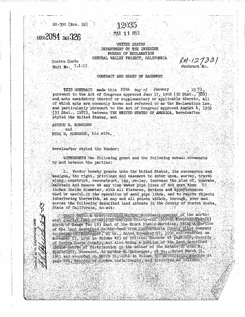
·-12035 MAR it 1953
. · tmiTED STATES DEP~ OF THE INTERIOR . BUREAU OF RECLAMAT!ON
CENTRAL VALLEY '1'ROJECT, CALIFORNIA
· CONTRACT AND GRANT OF EASEMENT .
/(It!/- I :2 1 ;jj. / contract No. .·
THIS CONTBACT made this 29th day· of JanuariY . .. 1 .19 53,· :r;>ursuant to the Act of Congress approved June 17, 1902 ( 32 Ste.t. ,388) · and aots amep.datory thereof or supplementary or appli-cable thereto i all o;f whioh acts. are, :commonly known and referred; to ·as·i:;he Reclamatiorr .Law, and particula;rly.purs':lant to the Act of Congress· approved Aui!;Ust 4, 1939 .(53 ptat •, 3:187), between THE UNITED STATES OF AMERICA, hereinafter . · styled the United Statef;), and . . '
ARTHUR JI, HONEGGER . ·a:nd ·
. MYRA li- IIONEOOE:I{, his Wife,
~ I • ~ ,1 -' ' "
h~rein(;l.ftE::~r styled the Vendor~ . '-- I •" ,' •'
,,11i!,:;
·· .. · 1wrrNmSSETH the following ·grant and the f'ollO'wing mutua.i\~ovc;lnants ·· ~Y .and betweE)n tpe parties : .
• . 'l . .

UBER2084 PA!iE327
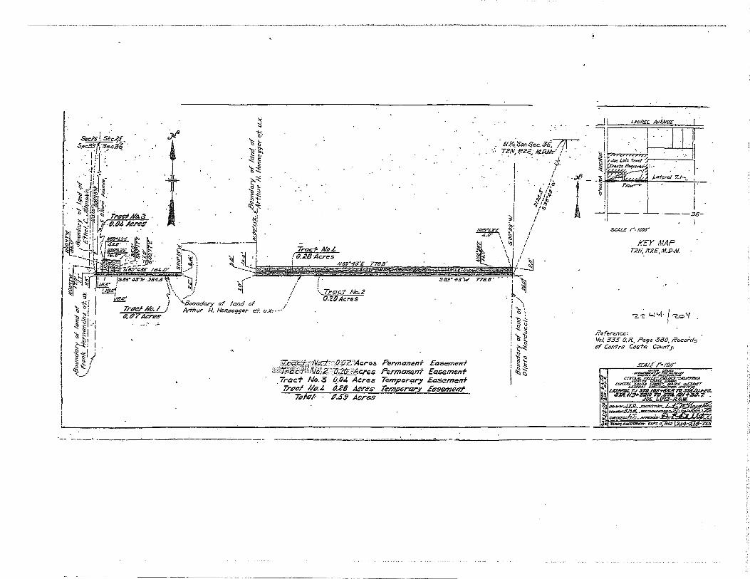
"'~~~g:iJm.ing. a;t.··~he· ·I+CI:Jt~11J:l~.~]. cox-ner'of tJ:lec'tl£~.1;\C\: qesqr:Lll~-~~J:n. sa,.i.a
~itii1ii=l~i~ti~~~1~1.·~~i!!f~f!:: seid-~asterlf.boundary e.llcf running South 899 . 43 I West 1265 .2' ':feect~to a :poillt Q.U .j;P:e :westerl:Y:boYJjdil,£y::-ot.~~~lie:;:t~indLd~~~~;t'bed ;in·.· ~a.~d- ae~~'. which
·.: .. ::trt "the westerly.boundary .. of said.· Section 36;-thence North.Ob0 !l3' :l!la,s;J:I ~~~o:pg f;laid westerly-boundary 5 .o feet iJO ·a P()int;,~said point. is South '
;()(}C! 13' West· 1654.9 feet from .the northwest :corne:C .. o;t'~:sa~§..;$~P:P~ol} :36; thence leaving said westerly boundary anq. r'lllliling North 89°· 43-, 'East\
.. q-B~:~.B.:•,feet :along· ·a' northeriy boundary· ori, the ·land" 9,escl'ibed in said '<i~$ti';'thenc~ North 00° 13' East 2.6 feet a16ng'tM west'~i:J..y~_bol.U],Cil:l.:qr of t:lJ.~-.;L~l).P:.4~.P~~ibed .in ·said ))ecree of Distribution; thence :.c6litinti#}'g . Nor'.tb.:(i)o2 >i3' Ea·st-a.long said westerly bcn:mq,a,r,yJ~.~-,:fe.~"fj;. thence leaving said we¢terly'bouridary and running Not'th 89~ 43'"'Eiih~~w~9:~o"'t~~ii H9 a . .· J?() :tn~ •. ·ll.~:re;tp.a:f:}ier' r~f~rr~ q . to . .as.·. 'l?9:i.n't •. 11BP; ..• -~l}E!lJ.E~ (lOUt in uilig ]~otth 89° 43''East-"132~0 feet·t() a·point '_oil the ea"Sterly~l)gJlil:<Mft:Yi"-9t:,~h_e land
. c:'iesot:~~~d; :;i,p.,: .. s;aid ::Oec:i:ee, and hereihat'ter. re(f'erred,:tQ_~:s·'poillt'"lld 1'.;i' .thence South 00° 13 1 Hest along· said f;)asterly houifaaty,~hOc~f~§t,.to.~ l'Pil1t; t~~nce: oontinuhtg South 00° 13 I West along said east~r1y~;i5Billit4iry :Ci9 ±'e'et; thehce ·North'89° .4311 :a:Eisti· '778'.i~,(f~/?;t"}l . :';;tl!~~"ll6Jt9:er;I.y bo~d.a:ry of the.J.a,:p,d%"-Q.escribedoin' said 'deed• to the point 'of~ =et:Urrtillg'?:io$!\~~i:t'J.i!'J,g o.2o"acre~;"ciliore·ar less. - · ·i>·.-
la. Vendor_also hereby grants -cinto the United States, its successors and assigns, the te:mporary right, pri v:i}ege .and easement to 'enter. upon and.· use Tracts T\·ro and Three, hereinafter described, for the .placing or :piling thereon of ear~h, materials and machinery and for other purposes usefu1 or : necessary i,n connection vi th the construct:lpn of its :pipe lines adjacent thereto. · Said temporary right, ;privile~e. and ·easement_ s'.b.all terminate not later than.i;W6 years after the colllllience:tnent of said.aonstruction, and u,pon completion of said construction or iri an;r event prior to the end of said. tloro-yeat'- period, the tJnited Sta·t;es shall restore the said land, as nearly
·. · .as may be pratrbicable, 'to the condition ·in;:which it.·wa:s pri'or to the commencement .of the use thereof by the United ~tates,; Said Tracts Two and Tllr.ee are in the southwest quarter o:t t}le no;i'tnwest ,quarter '(ffifk of l''lWft) of. said Section 36, are :por-tions of the ;Land;described:i:h said Q.eed to .. AJ:'.th'Ul;' H. Honnegger a.na of th~ land described in said Decree o;f Distribu,.. tion; contain a combined area-of'0.63 am.·e·, more· or le~s ~dar~ .desc~ibed
: i:l.S ~fOllOl-fS: . -- - - ' . -;: -'·'
; 'J!RAOT ~: ,BI;lSinning ~t·the 'i}Or~b,.eastc~ol,'ner oi',sai(LOTi'aC!t .One;·· ap..id. :f6:i.~t ';bei~g ta+'e:tn"b~fore refe;rred. t.o ~s ·• J?oiP,:b, 110 11
; ;r1.®1~ng. thehce. ~I' om .•. · s~id point of\b¢gibil~p.g :?.outh 8$1° .. 43 t West alQP,£5 :a nort)lerJ,y bound,ary ,of· ~aid T:raot one~ l3F;e··reet to :the ;point hereinbefore referre~ tp as J?oll,tit ,
. ,11B11;. ,thence l~ayip:g sa:i.d northerl,.y: pottnaB.ry f;t:Ud run:riilig North 00~ · :L3 1.,_1i}h.st .
J..6.o :feet .I thence North 89° 43' East 132.0 feet to a ·point ;in .the easte:cly I ' ,- ' ' ' •.;..t- ' -- - -"' ---' • +' - ,, > 't-- -- •- ' , - ', '•-- ---'- •--• -.

boundary of the·land described in said Decree, said point is North. 00° 131 East 16.0 ·feet from the· point 'o:t' beginning; thence South 00° 131 west alop.g said easterly boundary 16~0 feet to the point of beginning, containing 0.05 acre, more or less.
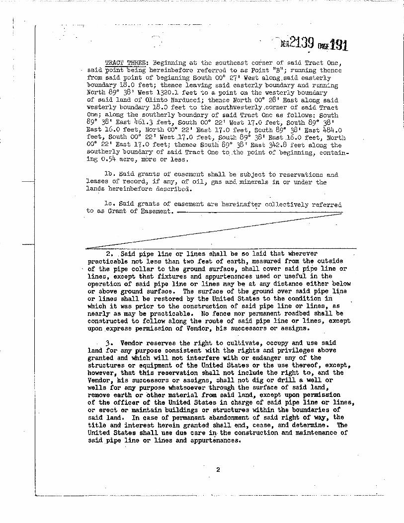
·TRACT THREE: Beginning at the . southeast corner of said Tract One, said point being hereinbefore referred to ar:t Point "A"; running thence
· :from said. point of beginning South 00° 28' West 20.0 teet a~ong t~e easterly boundary of the land described in said deed.; thence leav~g said easterly boundary and running Sol,lth 89a .43' rTest 1265.1 feet to a . · po:i;nt on the westerly bonnd.ary 'of the land described in said. deed; thence Nor.~h 00° 13' Eas~ along said. westerly boundar~ 20.0 feet to the southwest corner of sa~d Tract One; thence North 89 43 1 East 1265.2 feet almig the southerly bonnda;ry of· said Tract One .to the point of beginning, containing 0.58 acre, more or less. . .
. lb. Said grants of easement shall be subject to reservations and leases of record., if any, of oil, gas.and. minerals in or under the lands heJteinbefore described..
:Le. Said grants of ·easement a"t'e hereinafter collecti vel;y referred . to as Grant of Easement. . ·* · ·
· 2. Said. pipe line or lines shall be so laid that wherever . . practicable not :less than two feet of' earth, measured from the outside
or the pipe collar to.the ground surface, shall cover.said pipe line or · l:rl.es, e:xi:ept that fiXtures and appurtenances used or usefUl in the operation of said pipe l~ne or lines. may be at· any distance either below or above ground surface. ~e s~faoe of the ground over said pipe line pr lines shUl be restored by the' Un.itEid States to the .condition in which it was prior to the construction of said pipe line or lines, as.
·nearly as may be practicable~ .No fence nor permanent roadbed shall be .conf!tructed to follow a,long the ·.route. of said pipe line or lines, except upon.express permission of Vendor, his successors or.assigns.
3. .Vendor r,eserves 'the right to cultivate, occupy. and use said land for any purpose consistent with the rights and privileges .above granted and which Will not interfere With or endanger any of the . structures or equipment of the United States or the use thereof, except, however, that this reserv~tion shall not. include the right to, and the Vendor, his successors· or a.ssigns, shall not dig or drill a well or wells for. any purpose whatsoever through the surface of said land, remove earth·or other material fr~ s~id land,. except upon permission of the officer of the United States in charge ot said pipe line or lines,. or erect or maintain buildings or structures within the bowtdaries ·of said land •. In·c~se of permanent' abandonment-of said right of way, the title and iriterest herein grantep sh{tll end, ·cease, and determine. The United States shall use due care in- the c·onstruction and maintenance of said pipe iine or lines .and appurtenahces.
' .j . '
l ............... __ ........ ·--..................................... ~:.:.:..:: ..................... -··------.--......... J .. --·'- ....... -·"'""·--· ....................... ., ...... --~ ..... _:_~·. _ _:_:___;_jJ

•'
•., \ ' liBER2084 P4GE'329.
4. The grant of easement hli}rein contained is sub-ject to existing rights of wa.y for highvays, roads 1 ·railroads, canals, laterals, ditches, other pipe lines, electrical transmission lines anQ telephone and telegraph lines cov~ring any part of the a.bove-desc~ibed ·land.
5. As· complete consideration .for the ~bove grant of easement, the United States agrees to'pay to Vendor:
(a) . The amount of any damage to trees, seedlings , vines, crops, shrubbery, landscap~g and improve-ments within or on said land caused by·construction of said pipe line or lines , the ~mount· of paynient for said damage to be de:termined by an ·appraisal made by the United States Bureau of Reclamation.
:,:·!
(b) The reasonable eost of ~he relo.cation of . such ·. irrigation and pipe line facilities located on said land which the United States shall determine shall be reloaated by the Vendor. In ·lieu ·of the payment to Vendor ,of the cost of the relocation of said .irrigation and pipe line facilities' the United States may, at its option and expense, relocate said irrigation and pipe line facilities; and the ~endor shall so accept said payment or relocation.
Any irrigation or pipe line facility to be relocated as here-· in provided shall.be of quality and standard-equivalent to that of the existing ·facility, and any such facility shall be relocated to such land of the Vendor adjoining that herein described as the parties
. hereto shall mutually determine to be reasonable and proper. The ·united States .sha],l notify Vendor in writing as to the facilities .that must be relocated, and in such notice shall inform Vendor as to the date When such relocation must be completed and Of the reasonable cost,of such relocation. Payment to VendGr for the cost of said relocation shall-be made upon the completion of said relocation and shall be in an amount determined by·the United States Bureau of Reclamation to be the reasonable cost thereof~
It is a condition precedent to any paynJ.f.lints hereunder that any and all defects, interests, or encumbrances against the Vendor 1 s title to said land that may not be acceptable to the United States, other than those specified in Article 4 hereof, shall be removed by or on behalf of the Vendor. The rights of. the . Vendor under this artiale shall not be assignable and ahall not pass to any subsequent purchaser of the land or of any interest therein. ·
3
... -

'i
··. ··'.
'· i
6. It is ··understood and agreed that if the Secretary of the Interior determines that the title should be acquired by the United States by judicial procedure, either to procure a·safe title or·to obtain t~tle more quickly or for any other reason, then the. compensation
·to be claimed by the Vendor and the award to be made for said lands in said proceedings shall be upon the basis of the compensation herein-before provided. · ·
7• Where. the operations of this contract extend beyond the current fiscal year, it is understood that the. contract is made contingent upon Copgress making the necessary appropriation for expenditures thereunder after such current year has-expired. In. case such appropriation as may be necessary to c~rry out this contract is not made 1 the Vendor hereby releases the United States from all. Liability due to the failure of Congress to make such appropriation. ·
8. No member of or Delegate to Congress or Reside~t Commissioner shall be admitted to any share or part of this contract or to any · benefit that may arise herefrom, but this restriction shall not be construed to extend to this contract if made with a corporation or company for its general benefit. · ·
IN WITNESS WHEREOF, ·the parties have caused this contract to be . executed the date hereinabove written. ·
.Ar.PJ;OV® •• ~ l;tp t'oi'lll-..s~.
Witness
.....
THE UNITED STATES OF AMERICA
By _..r.:,£44:.:::;.:• =:;;;..u....;h:w~oU""'~~'4~&~;g;·~-·~}r~~ Regional Director
Vendor
·Vendor
. 4 ·c. .
' .
··, .. ; ..• ..·. ..."':.\,;·: ::t·. ·~ ., ' . . . '., .. ·. ·-·-- .~.- -------~ __ :_ ···--·-----·~~: ... :- ..... '. • ~ ... .......;;.~_'_i __ ~"""'-~~·...i,;.· .·"'-"·/ 'L._·, ~· ~.......:c.· C--··-• .. ·--·~- .. ·--"·- ......... • ........................ -·-· ...... .' .......... - . ......:.. ... :<J. .. _ .... ;

':'·
.,,
..... ' .
LI8£R2084 PAGE 331
STATE· OF C~FORN!A ~) . . ) ss.
C6urtty of · . . . .
; \·
~~~~~~~---' in th~ ;ve~r Notary
Public in and
appeared ~~~~~!-4(~~~~~~~~~~~~~~~~
known to me to be the
to the within instrument,
the same.
IN WITNESS WHEREOF I have hereunto set my hand a~d i ....
affixed my official seal the day and year in this certifiQa~e
first above writ,ten.
··~JCI)ires :
. RECORDED AT REQUEST Of RICHMOND MARTINEZ
'l'l'l'LlC COMPANY. · MAR 11 1953 .
At/tl.'$il o'eloclt~. If: 14. · lal Vot.t5{t?/1 aae .;.,::rot,'
.· . · (;l!JrlOJAL ON>s OJ . .
4P ..... ~ · ~ :COUNTY PICORDU
.:;-,..~!J·fo . .
.·.,. · .. ·. ··.
·=.··· '-. · .. :· ... : ..
""--"-.-.:.,.~c_____:__;,_~· -"'"··~~""'-..:..J:., ,}._·~' .. ;Ji.;;::;: .}: .. ,

~ Se.:K IS..:..?.> .... 5ec.J1 5;ft:;$' .
"< • I ~ll; I ,-:g { ~~ s ,...!% ~ ~\s I
-.;; I
. §~ : -~" \.":-- l
·Trt~cf /111 • .i tl.SII Ae-res
.rt'
~ + j ~~~~ cor. .:>"'"' Jc-::.;::::;-r-
.r.?N. lf2E, AI.O.!Itl. / I
of
/l /
• I'
"l·"~ f,,:; y~
it;! / ~ / . ! :1: I
~~i~KJ Htiir"JU~ RJZCrt 1(\t / ~~ I""C.\:5.... t.a .a· . I ~
-'!- ••.: A{#:/"'4,J-'Z{ ~ w~• • .A/8.9"".11.3'£ ?74. ~~ .. •
.' •• • .. /2t:S.2'.5Q':J"-9~"H' •.• (21:6:/" .• • • :-~-- '1 \. Tract Np,/ . "'
11.20Acrf!s
CJriJcl No;~rli iWilli·ZtJ ·Ae-res Pt>rmunenf £g.sement ·7rt~cfllfJ."2.' ·'a liS" 7tcru Tempgrr;ry EP.semenf Trtlcf No. 3 o.sa ANeS Temf)PrtJr.Y, Etl.semenf
Tflfqf: O.B.J Acres
hi J:-1 ~~ ~~ ~ t>
~~ ~-~ ~'§
l f
~(.
I ---JG-
$&4/i" r:.;oPo~ (
/rEY MAP TZU, If..?£., Al..b.M.
~oe~J ~~ li'el't'rence' Vol. 423 <2.1?.. ~e 4.5"8 <717a'
1&1. SOT Cl.l?. f'DP 48/, /ft'ciJn7s of tdnfro Cosk &un.ty.
VHIT HI/. T.l-/4"

ACQUIRED LAND (CARD CODE- 1) .,~.. PLAT PAGE No:' OVP-i/ .;;:7 _·
.. ;.:. · CAL!FO!MIA . 11 /' /' ) .,::;- • · · ··s.:rAtE ___ ..,.... ________ COUNTY t:.>D~·l f,.. a r.e <l-fe r f},J . CITY-.~CJ~p?~~-----.-~--:"";"~---! , PROJECT CENTRAL VALLEY DIVISION DELTA . UNIT. . DISTRICT-00NTRi],dSTA1
a, r:1 7 · -Wam·e:r m::st. · 'INDEX NO, "'Lt:L · UNIT NO. ,(- I 5"" PROJECT No._ID_ FEATURELateral '
TWP, :R, e. tt M. LOT 8L.OCK TRACT J1· .• " .. ' . ·- . '
!)/ IE. M, () -· ··--···· ..... ,o...-.,.-~.:.__.:. ···- ···~- ~ ••
;,J_ c-·'j~ ' .. ---~ .. ·--·--··-"---~··- ...... h0.00FO-
l. RANCHO
/ Eng;, Dwg. Nu, ;2 ; cf : J.,/ A.- 2/ ~-I Date W 1- (:, .. _\ 3 LAND IN GOVERNMENT CONTROL /' -'' · · ,..- ' · Acqollrli~ or l)hspoaed Balanaa-·A.areu
Stptl,~m I 0 8" f- (, ...\ •c.\"'' To Station /?.-I+ Jlo, 7 DATE · ·if.iE:·No- .... .,,.,..,. ·· · ...... ~ -·E-ASEME·N' ..
-~J.Ar.qulredfrum:f-irfilqv t/, 1/.ohe(.{e''/~ .. fttr(!-).-4,:;-·;:, ~ o.Y 6,.).-
" 2. Address: t' t. 0 D' ----~ t I e LJ; Qt>-L '·fo , ,., ;~"::
.-- 3, Acres acquired: Total _________ .:,:;o,;;;;·~.:._~~:;;;o~;';:;;o.~P~;;_·_.-~o:... _ _ ~..,;··_'-;;,..· --....l--:----'----.........1!..------IL.....--..,........J
0 r ?-0 I? 6 I !ffl../'e /4) 4 ve-Urban : Rural
4, Acres In fae: _________________ RBMARKS #~4l~~~<;!J- ~~)ii{J}li "5. Ac-res In eosernent: Totai ___ _::::O..!..'.;:.JJ:t..:.""3L.... _____ _
;6. Acres In perpetual ~osement: __ _;c?l::::...t-,_)~·5.<9:....--------
_: 7. Acres In t~mporory easement: __ _::.D.:.., b:'=!--32!--______ _
...-- 8, Expiration dote: 1-'irs. g..f:fe v 'S'lr.~ .-"/' GD )'Is 'f. ,.r • T I . I
9. Acres In access easement: ______ ...;_____,,-__,. __ _
10, Acres In flowage easement:
, ACQUISITION DATA
/ 1_1, Contract. No • .....=::::::;:::::::;:::::::;::=======Date: . ,/- 1--f.- ~ 3 REMARKS
./ 12. Nature of Document: Con±,ract & Grant of Easement
/ 13, Date: Recording date: 3 - ( /- S" 3
/ 14. Recorded: Book , Volume )rZl f ¥, Page 3 Y' {:;
15. Rights to ~a Issued tp grantor:- Yc.; No v
16, Declaration of Toklng-·Civll No,'
CONDEMNATION ACQUISITION
·---------REMARKS
17, Parcel No, __ . __ S111t nome: __________ _
18, Filing dote: _______ Final Judgment _____ _
19. Declaration of Taking - Ravestments ________ --'-
20. Amount paid tc> owner - Juclgment 1--------. Negotiated S On DepositS
u ;;J.._ t),·os-J.-r e£, ,,. .3- i), s-s> . ... -----_.a, 8 .3 ·
~ . pprol sol by: --4.C-'_t;,_7,!...·'1'-.:...' ...!.a.~-·,.~,.c::..f, .. f:...· • .t::r?.LY_._n~'?:...:"":z-~/'7..:....._ Total Appraisaii...£.Y_fi.~-;;...· -~---- Land orily -s_·_··_· ·_-_ .. _--_ . ._:_. __ .., 22, Amount puld to owner;
(Use us an uppruisal in condumnatiun)
Land 1....-------1 Severance ~-------i Improvements '--------,
Permon<lnt easement S....-.--,&4"-----1-'----
bJ T amporary eosemant·s __________ ...;
_£) ~'b
/114. Polley of Title Insurance: Co;.,p~ny_,di=-4<'--"-.'r-zf"-~"-r.c.h~.::."...:;:;,:.......</4...::t.<.:..<.:;;c.:.:.:/'-l;"'-,; __ . ,,_,,...,_·.._. __ Amount s_'v.;_:::J;_;;.o_.__ __ ... ...;·':..~i\torder No. I ;L 2 J 3 L
25, U. 5, Interests sublect to other Interests _ _;0 (!);.,' ;KL L/ 7
/23. T otol amount paid to owner: 1

R2-390 (Nov. 52)
·\
Contra Costa Unit No. 7.1-16
JUN 10 1953 30326
UNI'.rED STATES DEPARI'~~'T OF THE INTERIOR
BUREAU OF RECIJU1ATION CENTRAL VALLEY PROJECT 7 CliLIFORNIA
CONTRACT A.lW GRANT OF EASEMENT
u6Ei?2139 Dtt189
THIS CONTRACT made this 4th day of May 1 19 53 , pursuant to the Act of Congress approved June 17, 1902 ( 32 Stat . , ~8) and acts amendatory_thereof or supplementary or applicable thereto, all of which acts are commonly known ancl referred to as the Reclamation Law, and particularly pursuant to the Act of Congress approved August 4, 1939 (53 Stat., 1187), between 1rHE 1JNITED STATES OF AMERICA, hereinafter styled the United States, and
OLIIf.PO NARDUCCI, a single man,
hereinafter styled the Vendor:
wrrNESSETH the following grant and the follmving mutual covenants by and between the parties:
1. Vendor hereby grants unto the United States, its successors and. assigns, the right, privilege and easement to enter upon, survey, travel along, construct 1 reconstruct, lay, re·-lay 1 incre?-se the size of 1 operate 1
maintain and remove at any time water pipe lines of not more than 18 inches inside diameter, with all fixtures, devices and appUrtenances used or useful in the operation of said pipe lines 1 and to remove objects interfering therewith, at any and all poj.nts wit;hin, through, over and. across the following described land situate in the County of Contra Costa, State of California; to-wit: '
. ... TRACT • ONE; .. •.f!l.. tract of. :LE\ridi ir.t ·the earJt · ;g~Jt'l:tEi~t! .· .. q~r:tc:;r (Ei =of IV'IviD :~:risec-b:Lon Thi:r.'i:lY"'f3tx (36). ~n T6 ·• _ ~· €lfer.th·e:r• H~hg~
· - ~~~-t~<:?,t~,~h~ Mo<lnt Diablo Meridian! ?6e .·.·. . . ~~t:j;q];i·of j;he .. land. ~-d:-.~il1,"the deed from Minda.· Mudge., aria ·tenaJ-B:olz~ner ~.to <Dl;tntb
ar :ut;~SiJ ~<lwted.~octoqer 4, 1918 and recordecb~n<Nov~mber 2, 19i8 in VoluJit~!~f~~ ~eds"a~ Jlage :g~6~():f H~QqrQ.~cigf<~~l\3;' Gon~ra· pos:tl~:~:~·~WltY, contll:LJ±J.~l~ _J.~ore;, more or less, and described ·a.s follow·s: ' ·
'0~~0:'~'{.::~~;:'~~-t'~~~~-- - ,--- ! -~- ~- _,_-T~
Beginning at a point on the ivesterly boundal'Y of said land of Olinto Narducci; said point is South 37° 2~ t East 2074·.1+ feet from the northwest corner of said. Section 36; runni11.g thence from said. point o;f' beginning

r I I
... .'/:
North 00° 28 1_ Eas_t &long said westerly boundary 25.0 .feet to a point ' hereinafter referred to as Point 11A11
; thence leaving said westerly boundary and ru.tming South '89° 38 1 East 12.0 feet; thence South 00° 22 1 West 17.0 feet; thence South 89° 38 1 East 1308.1 feet to a point
. in the easterly boundary of said land of Olinto- Narducci; thence South 00° ·271 rlest along said easterly bounda17 8.0 feet to a point; said point is South 00° 27i West 1667.3 feet from the north quarter (Nt) ·corner of said Section 36; thence continuing south 00° 27 1 West:along .said easterly boundary 8.0 feet to a point hereinafter referred to as _Point 11B 11
; thence leaving said easterly bmmdary and rtuLl'lil'lg North 89° 38 1 West.342.8 feet; thence south 00° 22 1 West 17.0 feetj thence North
.89° 38 1 West 16.0 feet; thence North.00° 22 1 East 17.0 feet; thence North 89° 38 1 West 484.0 feet; thence South 00° 22 1 West 17.0 feet; thence North 89° 38 1 West 16.0 f.eet; thence Nor.th 00° 22 1 East 17 .. o feet; thence North 89° 38' riest 461.3 feet to a point' on the westerly boundary of said land .of Olinto Narducci; said point is South o·oo 28 1
.West 8 .o feet from the point of beginning; thence North 00° 28' East along said westerly boundary 8.0 ~eet to the point of beginning.
la. Vendor also hereby grants unto the United States, its successors and assigns, the temporary right, privilege and ease~nt to enter upon and use Tracts Two and Three, hereinafter described, for the placing or piling ther~on of earth, materials and machinery ~nd fo1· other purposes useful or necessary in connection with the construction of its pipe lines adjacent thereto. Said temporary right, privilege and easement shall terminate not later than t-vro years after the commencement of said ~onstruction, and upon completion of said construction or in any event prior to the end of said two~year period, the United States shall restore the said land, as nearly as may be practicable, to the condition in which it was prior to the commencement of the use thereof by the United States. Said Tracts Two and Three are in the northwest quarter (NWt) of said Section 36, are portions of the land . described in said deed, contain a combined area of 1.14 acres, more or less,· and are described as follows:
TRACT TWO: Beginning at the most northwesterly corner of said Tract One, said.point being hereinbefore referred to as Point 11A11
_; running thence from said point of beginning North 00° 28' East 3.D.feet along the westerly boundary of said land of Olinto .Narduccij thence leaving
··. said westerly boundary and running South 89° 38 1 East 1320.1 feet to a point on the easterly boundary of saiQ land.of Olinto Narducci; therice South 00° 27t West along said easterly boundary 20.0 feet to the most northeasterly corner of said.Tract One; thence North 89° 38' West 1308.1 feet along the northerly boundary of said Tract One; thence North 00° 22 1 East 17.0 feet; thence North 89° 38' West 12.0 feet to the point_ of beginning, containing an area of.0.60 acre, more or less.
la
.
I.
.r--·.
TRACT THREE: Beginning at the southeast corner of said Tract One, said point being hereinbefore referred to as Po;i.nt 11Bu; running thence from said point of beginning South OQ0 27' West alo~g.said easterly boundary 18.0 feet,; thence leaving said easterly botmdary and running North 89° 38' West 1320.1 feet to a point on the westerly boundary of said land of Olinto Narducci; thence North 00° 28 1 East along said westerly boundary 18.0 feet to the :southwesterly.corner of said Tract One; along the southerly boundary of said Tract One as follows: South 89° 38' East 461.3 feet, South 00° 22 1 West 17.0 feet, South 89° 38 1
East 16.0 feet' north 00° 22 I East 17.0 feet J South 89° 38 I East 4.84. 0 feet, South 00° 22 1 West.17.0 feet, South 89° 38 1 East .16.0 feet, North ooo 22 1 East 17 .o feet; thence South: 89° 38' .East 342.8 feet along the southerly boundary of said Tract One t~_the point of beginning, contain-ing 0.54 acre, more or less. ·
lb. Said grants of easement shall be subject to reservations and leases of record, if any, of oil, gas and minerals in or under the lands hereinbefore described.
lc. Said grants of easement are hereinafter collectively referred
2 •. Said pipe line or lines shall be so laid that wherever pra.cticable not less than two feet of earth, measured from the outside of the pipe collar to the ground surface, shall cover said pipe line or lines, except that fixtures and appurtenances used or useful in the operation of said pipe line or lines may b~ at any distance either below or above ground surface. The surface of the ground over said pipe l~ne or lines shall be restored by the United States to the condition in which it was prior to the construction of said pipe line or lines, as nearly as may be practicable. No fence nor permanent roadbed shall be constructed to follow a.long the route of said pipe line or lines, except upon express permission of Vendor, his successors or assigns.
3· Vendor reserves the right to cultivate, occupy and use said land for any purpose consistent with the rights and privileges above granted and Which will not interfere .with or endanger any of the structures or equipment of the United States or the use thereof, except, however, that this reservation shall not include the right to, and the Vendor, his successors or assigns, shall not dig or drill a well or wells for any purpose whatsoever ·through the surface of said land, remove earth or other material from said land, except upon permission of the officer of the United States in charge of said pipe line or lines, or erect or· maintain buildings or structures within the boundaries of said land. In case of permanent abandonment of said right of way, the title and interest herein granted shall end, cease, and determine. The United States shall use due care in.the construction and maintenance of said pipe line or lines and appurtenances.
2

I I
LIBEA2139 ms£192
.-· ·. ,_,;, . 4. The grant of easement herein contained is subject to existing rights of way for highways 7 roads 1 railroads, canals, laterals, ditches, other pipe lines, electrical transmission lines and telephone and tele·graph lines covering any part of the above-described land.
5. As complete consideration for the above grant of easement, the United States agrees to pay to Vendor:
· {a) The amount of any damage to trees, seedlings, · vines, crops, shrubbery, landscaping and improvements within or on said land caused by construction of said pipe line or.lines, the amount of payment for said damage -to be determined by an· a]?praisal made by the United States Bureau of Reclamation.
. r •
(b) The reaso~ble cost of the relocation-of such irrigation and pipe line facilities located on said land which the United States shall determine shall be relocated by the Vendor. In lieu of' the payment to Vendor of the cost of the relocation of said irrigation and pipe line facilities, the United States may, at its option and expense,. relocate said irrigation and pipe line facilities; and the Vendor shall so accept said payment or relocation.
Any irrigation or pipe line facility to be relocated as here-in provided shall be of quality and standard equivalent to that of the existing facility, and any such facility sbal~ be relocated to such land of the Vendor adjoining that herein described as the parties hereto shall mutually determine to be reasonable and proper. The United states sbal+ notify Vendor in writing as to the facilities that must be relocated, and in such notice shall inform Vendor as to the date when such relocation must be com]?leted and Qf the reasonable cost of such ·relocation. Payment to Vendor for the cost of said relocation shall be made upon the completion of said relocation and shall be in an amount determined by the United States Bureau of Reclamation to be the reasonable cost thereof.
It is a condition precedent to any payments hereunder that any and all defects, interests, or encumbrances against the Vendor's title to said land that may not be acceptable to the United States, other than those specified in Article 4 hereof, shall be removed by or on behalf of the Vendor. The rights of the Vendor under this article shall not be assignable and shall not pass to any subsequent purchaser of the land or of any interest therein. ·
3

6. It is understood and agreed that if the Secretary of the Interior determines that the title should be acquired by the United States by judicial procedure, either to procure a· safe title or to obtain title more quickly or for any other reason, then the compensation to be claimed by the Vendor and the award to be made for said lands in said proceedings shall be upon the basis of the compensation hereinbefore provided.
7. Where the operations of this contract extend beyond the current fiscal year, it is understood that the.contract is made contingent upon Congress making the necessary appropriation for expenditures thereunder after such current year has expired. In case such appropriation as may be necessary to carry out this contract is not made, the Vendor hereby releases the United States from all liability due to the failure of Congress to make such appropriation.
8. No member of or Delegate.to Congress or Resident Commissioner shall be admitted to any share or part of this contract or·to any benefit that·may arise herefrom, but this restriction shall not be construed to extend· to this contract if made with a corporation or company for its general benefit.
IN WITNESS WHEREOF, the parties have caused this contract to be executed the date hereinabove written, '
,li'PI()Yro .;_ te Lep! .... ~.
Witness
THE UNITED STATES OF AMERICA
Vendor
Vendor
Vendor
4 -: ..

· uom2139 mti£194. R-2-293 Mar. 52
STATE OF CALIFORNIA ) ) ss.
County of Sacramento )
On.this 6th day of. May , 19Jl, before me MARY R·. MULCAHY, a Nota.ry Pub].ic in anq for the County of Sacramento, State of California, residing therein, duly commissioned and sworn, personally appeared LeRoy Minturn known to me to be the person whose name is. subscribed to the within instrument as a witness thereto, who, being by me duly sworn, depose~ and said: that he resides in the County of
~ameda · , State of California; that he was present. and saw
OLINTO NARDUCCI, a single man,
personally known to him to be the person the within instrument as vendor the same; that the said
OLINTO NARDUCCI, a single man,
described in, and who executed thereto, sign, seal, and deliver
duly acknow~edged in. the presence of said affiant, that he ·executed the same, and that he, the said affiant, thereupon, and at the request o.f said vendor subscribed his name as witness thereto.
IN WITNESS WHEREOF I have hereunto set my hand and affixed ~ qfficial seal in the County of Sacramento. the qay and year in this certificate first above written. · ·
'. · ... -~fij ~'Hf ~cemnWf?sion E?q>ire s: ·
·.·.:.~;~~:i~~~;,~-,:~~·>~e .-·4·, 1955 .. . ·.- : ... ~ i ' ,. ! . • •
. ·.:;'-.,• . .

·~Se<.ZS So: -.=~ :.(/\
1 ~u.t ~ 1---l
~ \~ t \ril
-~· 'S~ ~~ {5"'
\~ \\ "'I "'' ~\
"""' "'"b
~\~~
,:_..
~-·-·
~r . ~ ~; ,tf "'._, ~-~~ ~~: -'\)~I "''"' '-"" ..g.~...,
§~: ~-~I '--::..j
l
;tl."
~i{~t '"""'~ .,.~-~
~
:.T~e.~:r~ofc,J~ '':6: 5l:3!i:ii1i!4c?es Trc;ct No. 2 0. 6 0 Acres Tract- Nc. 3 0.$4 Acres
To-tc;f: 1.64- Acres
P12rmernen-t Ea-sement TemporQry EasemenT
Temporerry . Easemen-t-
- •. -..w. . ·-
NY+ C<>r. ~.30,--""".
1 ,
T.R N, lf'i?£; M.P. /If. \
.k \
I \ I" \ I
J ~Mu~= ~v=vuo__l..__
l l
~~ r----177777777777/J ~j
' "' ' ""]Q ::I: ~ ~=;::~
"'! .... ~ " <:>"' V) "
I
~~~i~ !) ~ I ~.<! ·t~
I ~" §L!:: ~~--; ,--
--~~ Lateral 7.1
~I "'I
J.~ - tr<tuu1 36-ol I
SCAt.£ I"• 1000•
KEY MAP T2N, R2£. M.D.M.
'VI~·t~{t£-r
Referen<e: VoL 3Z7 P., flrpe S.?O, lf"«ord's cf Co/7-tra Cos-to Coun-ty.
SCALE /'•lOP' '~ ~ ~ ...........

ACQUIRED LAND (CARD CDDB - 1) PLAT PAGE NO, CVP ... iz .;_ 7
. /. CALIFO.fai!IA /l SJ' A lie----------- COUNTY Lo..., fr- s CITY t!) s-
. PRCbECT CENTRAL VALLEY DIVISION DELTA
INDEX NO f2_ UNIT NO
UNIT DISTRICT~O~TRAia:O~TA a e:r · · s •.
PROJECT NO _g;lli_ FEATURE Lateral . . ·,s.~bl"ioN TWP. :R. B. 6 M. L.OT BLOCK TRACT
:'3 'r;,··,. )--(1/ ~--F 1'1,1) - - - . ~- ·-. - -· ... - . ··-- ~--~· --· .. ~ . ... RANCHO
-~'2W·. pwg. No.2 I tf~;;~.; .r~ Ll C.l-?ote &e~c. 4-9-S:.3 LAND IN GO,VERNMENT CONTROL '
~,tptlpl)~ ?.!y 3t>' 7 To Station I!:> Lf -;-. .ro,£ DAT.E
Acquired lrom:.L2& T'o If/a vdi:l. / .. s ---1/,.s--- :e ~ 1. c. C I
I
/2. ·_z Address: U2::: ~.r;.c:. ,.Mtz r 1 e La..a e, ~ t'o c__ 1i(Y0 n ~ IL' rfa r e1 / .... ,- I I ""
3. Acres acquired: Total . cO'J&;:tl•c
/'6. Acres In perpetual easemant: ____ _:O:.:':.c:~:::...:O::::_ ____ _
.....- 7. Acres in temporary easement:. ____ f../:.:.:i.~:!.l_<-/...~-_____ _
8, Expiration dote; ,?l CfC5o aj f.c C 5 t:a I" I Con "i {-, 1
9. Acres In access easement; ____________ _
10, Acres In flowage easement:
'
ACQUISITION DATA
/ Il, Contract. No./ cf- 0 C, ~ '>) g~ ~· 7. 3 ,:; Date: J-r </. -= S, 1 RBMARKS
--12, Nature of Document:.Cantract & Grant of Easement,
_- 13. Date: Recording date: b ~ro ~ C. 3
/ 14. Recorded: Book , ValiJme ). f 3''7 , Page / rf[
15. Rights to be Issued t9 grantor: Yes ___ Nr;> v"'
CONDEMNATION ACQUISITION
16, Declaration of Toklng-·Civll No. ·-------------REMARKS 17. Parcel No. ____ Suit nome: __________ _
18, Filing dote: ·------ final Judgment, _____ _
19, Declorotlon of Taking- Revestments _________ _
20. Amoont paid to owner- Judgment 1----------.Negotiated S On Deposit I
Acquired ar Dlspoattd lhlana•- Acral ttJI"·I.Ir ~M:R£s .. p ···-··- ... -E·ASiiMEN'T -
G o, $" o, s--
..!:"'~ Total Appraisal g...!'J;:...:J::::_ _____ Land only I ______ _
22, Amount paid to owner: Land f., ________ Severance 1..,--------i Improvements~--------(Use us an appraisal r?
in condemnation) Permo11ent easement ~----..,i";..:.·~/------ lr· ; -'2.3. T otol amount paid to owner: 1 .DONAif'WN @if'~>o<~ T emporory eosement '-----------'
~4. Policy of Title Insurance: Compony_&;:::;_.:..-b'-L':,:..f.n;zu..C-<./.t..? "-~"'P'--'/....:~.::....:C..=.e:./-;' /."-'. ''-"/-'"'"", ''-- Amount I e7 ._(d I I
Order No. /1 7 .') 3 J./
torJ._ .. IJ./ I 2), U.S. Interests subject to other interests

EXHIBITB
30N3AV :iiSOtl
1i l··.· ·;
~ f ~
I I

EXHIBIT 'B-1' LEGAL DESCRIPTION
EXHIBITB-1 (3 Pages)
ALL THAT CERTAIN REAL PROPERTY SITUATE IN THE CITY OF OAKLEY, COUNTY OF CONTRA COSTA, STATE OF CALIFORNIA, MORE PARTICULARLY DESCRIBED AS FOLLOWS:
BEING A PORTION OF THE NORTHWEST V4 OF SECTION 36 TOWNSHIP 2 NORTH RANGE 2 EAST, ALSO BEJNU A PORTION OF GRAPEVlNE LANE (60' WIDE) AND O'HARA A VENUE (1 00' WIDE) MORE PARTICULARLY DESCRIBED AS FOLLOWS:
A STRIP OF LAND 16 FEET IN WIDTH, LYING 8 FEET ON BOTH SIDES OF THE FOLLOWING DESCRIBED CENTERLINE:
COMMENCING AT THE INTERSECTION OF O'HARA A VENUE AND THE SOUTII LJNE OF PARCEL D AS SAID PARCEL IS SHOWN ON THAT CERTAIN PARCEL MAP FILED ON MARCH 27, 1974 IN BOOK 32 OF PARCEL MAPS AT PAGE 48 IN THE OFFICE OF THE COUNTY RECORDER OF CONTRA COST A COUNTY,
THENCE SOUTH 89°17'35" EAST, 35.00 FEET TO THE POINT OF BEGINN1NG;
THENCE NORTH 00°57'43" EAST, 305.51 FEET TO A POJNT WHICH IS 13 FEET SOUTH, MEASURED AT RIGHT ANGLES FROM THE CENTERLINE OF GRAPEVINE LANE;
THENCE ALONG A LINE WHICH IS PARALLEL WITH AND DISTANT 13 FEET SOUTH FROM SAID CENTERLINE OF GRAPEVINE LANE THE FOLLOWING COURSES:
SOUTH 89°17'19" EAST, 314.93 FEET;
THENCE, ALONG A TANGENT CURVE TO THE LEFT WITH A RADIUS OF 413.00 FEET, THROUGH A CENTRAL ANGLE OF 20°45'57", AND AN ARC LENGTH OF 149.68 FEET;
THENCE, ALONG A REVERSE CURVE TO THE RIGHT WITH A RADIUS OF 387.00 FEET, THROUGH A CENTRAL ANGLE OF 20°45'57", AND AN ARC LENGTH OF 140.26 FEET;
THENCE SOUT~ 89°17'22" EAST, 417.04 FEET;
January 18, 2006 C:\DOCUME~ 1 \dsestero\LOCALS~ 1 \Temp\200443-CCWD-EASE.doc
(e~\r\1.\oi\- B-\ ~ 3 ~"-:.)

THENCE, ALONG A TANGENT CURVE TO THE RlGHT WITII A RADIUS OF 987.00 FEET, THROUGH A CENTRAL ANGLE OF 24°06'42", AND AN ARC LENGTH OF 415.36 FEET;
THENCE SOUTH 65°10'40" EAST, 455.97 FEET;
THENCE, ALONG A TAN GENT CURVE TO THE LEFT WITH A RADIDS OF 1113.00 FEET, THROUGH A CENTRAL ANGLE OF 24°03'16", AND AN ARC LENGTH OF 467.27 FEET;
THENCE SOUTH 89°13'56" EAST, 272.90 FEET TO A POINT ON THE CENTERLINE OF ROSE A VENUE
CONTAINING 47,023 SQUARE FEET OF LAND, MORE OR LESS.
January 18, 2006 C:\DOCUME~ 1 \dsestero\LOCALS~ 1 \Temp \200443-CCWD-EASE.doc

VICINITY MAP NTS
- ~:______,______,ro LANr 1)... ~ 1----+---i
1 ~ 1---+-----1
J~ --c:l
) j
L=149.68' R=413.00 L!=20'45'57"
EXHIBIT "B-1"
____ .... _
SCALE. 1"=300'
L=140.26' . LEGEND R=387.00 . POB POINT OF BEGINNING b=20'45'57." POC POINT OF COMM£NCE.MEN
ESMT EASEMENT ROW RIGHT OF WAY
INC. 2255 YGNACIO VAl-l-EY ROAD, SUiTE C WALNUT CREEK, CA. 94596-3349
PHONE 925 9.37-933.3 FAX 925 9.37-7926
EXHIBIT "B-1" CCWD EASEMENT
CHECKED BY: DOl
SCALE: 1''=300'
DRAWN BY: BJL
DATE: 01/18/06
JOB NO. 200443
SHEET 1 OF 1

EXHIBITC
WHEN RECORDED MAIL TO:
U.S. Department of the Interior Bureau ofReclamation, MP-450 2800 Cottage Way Sacramento, CA 95825-1898
DOCUMENTARY TRANSFER TAX: None This conveyance is exempt from any documentary transfer tax per California Revenue and Taxation Code Section 11922.
Central Valley Project Contra Costa Water District County of Contra Costa Coutract 07-LC-20-9519 Units7.1-14, 7.1-lS,and 7.1-16 Pagel of 6
UNITED STATES DEPARTMENT OF THE INTERIOR
BUREAU OF RECLAMATION SOUTH-CENTRAL CALIFORNIA AREA OFFICE
CONTRA COSTA WATER DISTRICT DISTRIBUTION SYSTEM CENTRAL VALLEY PROJECT, CALIFORNIA
CONTRACT AND GRANT OF PERMANENT EASEMENT for
RELOCATION OF LATERAL 7.1 UNITS 7.1-14;-7.1-15, AND 7.1-16 DISTRIBUTION SYSTEM
(6 Pages)
THIS AGREEMENT, made this . day of , 2007, pursuant to the Act of June 17, 1902, (32 Stat. 388) and acts am-endatory thereof and supplementary thereto, and. Section 14 of the Reclamation Act of August 4, 1939, (53 Stat. 1187), all of which acts are commonly referred to as the Federal Reclamation laws, between the UNITED STATES OF AMERICA, hereinafter the United States, represented by the officer executing this Agreement, his duly appointed successor, or his authorized representative, hereinafter referred to as the Contracting Officer and the City of Oakley, hereinafter the City.
WITNESSETH: The following grants, rights, and mutual covenants by and between the parties hereto which are acquired for the use of the Bureau of Reclamation; Depattment of the Interior, its agents, or assigns:
1. For the consideration hereinafter expressed, the City does hereby grant, bargain, convey and confirm unto the United States and assigns, the rights, privilege, and permanent easement to layout, construct, reconstruct, inspect, operate, repair, and maintain an underground lateral; together with all necessary appurtenances, suppotts, fixtures, facilities, and devices, used or useful in the operation of said lateral through, over, under, and across the lands as shown in Exhibit A and more particularly described in Exhibit B, both of which Exhibits are attached hereto and made a part hereof.

Central Valley Project Contra Co11/a Water District County of Contra Costa Contract #07-LC-20-9519 Page2of6
2. Said underground lateral will remain the property of and be maintained by the United States, its successors and assigns.
3. If the United States or District requires subsequent relocation of the new lateral, the District agrees to either relocate the lateral at its own expense or reimburse the City for the costs of the relocation, including the cost of restoring the roadway. If the City requires subsequent relocation of the new lateral, then City will reimburse the District or the United States for the costs of relocation. The United States shall not incur any cost for such relocation .
.4. If a leak occurs in the new lateral or other damage is caused by a defect in the new lateral which damages the City's roadway, the District shall reimburse the City the costs of repairing the roadway. The United States shall not h1cur any cost for such repair.
5. If the roadway damages the new lateral, the City will reimburse the District or United States for the costs of repair or relocation, if necessary. The United States shall not incur any cost for such repair or relocation.
6. The Grant of Easement herein contained shall include the right to (a) trim, cut, fell and remove underbrush, obstructions, and any other vegetation, structures, or obstacles within the limits of the easement, (b) store vehicles, equipment, and construction materials, and (c) such iJther uses requisite in the layout, construction, reconstruction, operation, use, maintenance, inspection, and repair of said underground lateral.
7. The City, its successors and assigns, reserve the right to use the premises for any purposes which-will not interfere with the easement, rights, and privileges herein granted to the United States, or endanger any of its property, but such reserved rights shall not extend to or include the erection of any buildings or structures, or permission to the public to use subsurface part thereof, for any reason or purpose, without adv_ance. written permission on behalf of the United States or its assigns.
8. The Grant of Easement herein contained is subject to existing rights-of-way for highways, roads, railroads, canals, laterals, ditches, pipelines, electrical transmission lines, telegraph and telephone lines on, over and across the lands described in said Exhibits A and B and to any mineral rights of record outstanding in third parties on the date ofthis Contract.
9. As complete compensation and consideration for the Grant of Easement and the use of said lands by the United States as provided in this Contract, the United States has granted the right to relocate Lateral 7.1 of the Unit 7.1-14, 7.1-15, and 7.1-16 of the Distribution System onto certain lands to be dedicated to the City in accordance with the terms and conditions of Contract 06-LC-20-9323 entitled, RELOCATION AGREEMENT FOR CONVEYANCE AND RELOCATION OF LATERAL 7.1 OF UNITS 7.1-14, 7.1-15, and 7.1-16 OF THE LATERAL DISTRIBUTION SYSTEM, dated-------
10. The City warrants that no person or agency has been employed or retained to solicit or secure thi$ Contract upon an agreement or understanding for a commission, percentage, brokerage, or contingent fee excepting bona fide employees or bona fide established agencies maintained by the City for the purpose of securing business. For breach or violation ofthis warranty, the United States shall have the right to annul this Contract without liability or in its discretion to require the City to pay the full amount of such commission, percentage; brokerage, or contingent fee.

Central Valley Project Contra Costa Water District County of Contra Costa Contract #07-LC-20-9519 Page3oj6
11. No Member of Congress shall be admitted to any share or part of this Contract made, entered into or accepted by or on behalf of the United States, or to any benefit to arise thereupon.
IN WITNESS WHEREOF, the parties hereto have executed this Contract the day and date first above written.
THE CITY OF OAKLEY A Municipal Corporation
By: __________ _
Title:-----------
ACKNOWLEDGMENT
STATE OF CALIFORNIA County of ______ _
On before me, , personally (Here Insert name and title of the ofjlcer)
~ppeared:---:-----~------,--------:--=---:-~---::-:---:---:--:---~· personally known to me (or proved to me on the basis of satisfactory evidence) to be the person(s) whose name(s) is/are subscribed to th~ within instrument and acknowledged to me that he/she/they executed the same in his/her/their authorized capacity(ies), and that by his/her/their signature( s) on the instrument the person(s ), or the entity upon behalf of which the person(s) acted, executed the instrument.
WITNESS my hand and official seal.
Signature
(Seal)

EXHIBIT A' LEGAL DESCRIPTION
Central Valley Project Contra Costa Water District County of Contra Costa Contract #07-LC~20-9519 Page 4 of6
ALL THAT CERTAIN REAL PROPERTY SITUATE IN THE CITY OF OAKLEY, COUNTY OF CONTRA COSTA, STATE OF CALIFORNIA, MORE PARTICULARLY DESCRIBED AS FOLLOWS:
BEING A PORTION OF THE NORTHWEST Y4 OF SECTION 36 TOWNSHIP 2 NORTH RANGE 2 EAST, ALSO BEING A PORTION OF GRAPEVINE LANE (60'. WIDE) AND O'HARA AVENUE (100' WIDE) MORE PARTICULARLY DESCRIBED AS FOLLOWS:
A STRlP OF LAND 16 FEET IN WIDTH, LYING 8 FEET ON BOTH SIDES OF THE FOLLOWING DESCRIBED CENTERLINE:
COMMENCING AT THE INTERSECTJON OF O'HARA AVENUE AND THE SOUTH LINE OF PARCEL D AS SAID PARCEL IS SHOWN ON THAT CERTAIN PARCEL MAP FILED ON MARCH 27, 1974 IN BOOK 32 OF PARCEL MAPS AT PAGE 48 IN THE OFFICE.OF THE COUNTY RECORDER OF CONTRA COSTA COUNTY,
THENCE SOUTH 89°17'35" EAST, 35.00 FEET TO THE POINT OF BEGINNING;
THENCE NORTH 00°57'43" EAST, 305.51 FEET TO A POINT WHICH JS 13 FEET SOUTH, MEASURED AT RIGHT ANGLES FROM THE CENTERLINE OF GRAPEVINE LANE;
THENCE ALONG A LINE WHICH IS PARALLEL WITH AND DISTANT 13 FEET SOUTH FROM SAID CENTERLINE OF GRAPEVINE LANE THE FOLLOWING COURSES:
SOUTH 89°17'19" EAST, 314.93 FEET;
THENCE, ALONG A TAN GENT CURVE TO THE. LEFT WITH A RADIUS OF 413.00 FEET, THROUGH A CENTRAL ANGLE OF 20°45'57", AND AN ARC LENGTH OF 149.68 FEET;
THENCE, ALONG A REVERSE CURVE TO THE RIGHT WITH A RADIUS OF 387.00 FEET, THROUGH A CENTRAL ANGLE OF 20°45'57'', AND AN ARC LENGTH OF 140.26 FEET;
THENCE SOUTH 89°17'22" EAST, 417.04 FEET;
January 18, 2006 C:\DOCUME~ 1 \dsestero\LOCALS~ 1 \Temp\200443-CC\VD-EASE.doc

<.:entra/ Valley Project Contra Costa Water District County of Contra Costa Contract #07-LC-20-95/9 Page 5 of6
THENCE, ALONG A TANGENT CURVE TO THE RIGHT WJTH A RADIUS OF 987.00 FEET, THROUGH A CENTRAL ANGLE OF 24°06'4211
, AND AN ARC LENGTH OF 415.36 FEET;
THENCE SOUTH 65°10'40" EAST, 455.97 FEET;
THENCE, ALONG A TANGENT CURVE TO THE LEFT WJTH A RADIUS OF 1113.00 FEET, THROUGH A CENTRAL ANGLE OF 24°03'16", AND AN ARC LENGTH OF 467.27 FEET;
THENCE SOUTH 89°13'56" EAST, 272.90 FEET TO A POINT ON THE CENTERLINE OF ROSE A VENUE
CONTAINING 47,023 SQUARE FEET OF LAND, MORE OR LESS.
January 18, 2006 C:\DOCUME-1 \dsestero\LOCALS~ I \Temp\200443-CCWD-EASE.doc

=····
~ I

RESOLUTION NO. XX-14
A RESOLUTION OF THE CITY COUNCIL OF THE CITY OF OAKLEY ACCEPTING THE GRAPEVINE LANE OFFERS OF DEDICATION
ASSOCIATED WITH SUBDIVISIONS 8760, 7662, 8734 AND PARCEL MAP 32 PM 48
Attachment 3
WHEREAS, on January 9, 2006 the City of Oakley adopted Resolution 03-06 approving the final map for Subdivision 7662 and said map made certain offers of dedication of right of way including the future Grapevine Lane; and
WHEREAS, on January 9, 2006 the City of Oakley adopted Resolution 05-06 approving the final map for Subdivision 8760 and said map made certain offers of dedication of right of way including the future Grapevine Lane; and
WHEREAS, on May 14, 2007 the City of Oakley adopted Resolution 59-07 approving the final map for Subdivision 8734 and said map made certain offers of dedication of right of way including the future Grapevine Lane; and
WHEREAS, on March 27, 1974 Parcel Map 32 PM 48 was recorded in the office of the Contra Costa County Recorder and said map made certain offers of dedication of right of way including the future Grapevine Lane; and
WHEREAS, on October 14, 2008 a Relocation Agreement was executed between the United States Bureau of Reclamation, the Contra Costa Water District, the City of Oakley, and Discovery Builders, Inc., Albert D. Seeno Construction Co., and West Coast Builders, Inc. (collectively the Developer) which allowed for the Developer to relocate certain irrigation laterals that ran through easements on several lots contained within the Developer's Subdivision 7681;and
WHEREAS, the Relocation agreement requires, among other items, the Developer to dedicate right of way to the City and for the City to accept the right of way in the Developer's Subdivisions 7662, 8760 & 8734 as well as that which was dedicated by Parcel Map 32 PM 48; and
WHEREAS, the Developer desires to relocate said irrigation laterals into the future Grape Vine Lane in accordance with the Relocation Agreement and has requested that the City accept the offers of dedication to allow the Developer to proceed with the relocation; and
WHEREAS, Staff determined that the offer of dedication associated with Parcel Map 32 PM 48 was rejected and terminated by the recordation of the final map for Subdivision 8734 and that pursuant to Section 66477.2(a) of the Subdivision Map Act the City Council may rescind its action and accept the offer of dedication by resolution;
Page 1 of 2

NOW, THEREFORE, BE IT RESOLVED AND ORDERED, by the City Council of the City of Oakley that the Rejection and Termination of the Offer of Dedication by Parcel Map 32 PM 48 is hereby rescinded and that the Offers of Dedication of Right of Way described above are hereby accepted by the City.
PASSED AND ADOPTED by the City Council of the City of Oakley at a meeting held on the 281
h of October, 2014 by the following vote:
AYES: NOES: ABSTENTIONS: ABSENT:
APPROVED:
ATTEST: Randy Pope, Mayor
Libby Vreonis, City Clerk Date
Page 2 of 2