census of india 2011 w ar k a fro m d w a r ka a to ... census of india 2011 gujarat series-25 ......
TRANSCRIPT
GUJARAT
SERIES-25 PART XII-B
DISTRICT CENSUS HANDBOOK
PORBANDAR
VILLAGE AND TOWN WISE
PRIMARY CENSUS ABSTRACT (PCA)
DIRECTORATE OF CENSUS OPERATIONS
GUJARAT
Census of India 2011


R
R
R!H
!
!
!
!
!
!
!
!!(
!(
!(!(
!(
!(
From Dwarka
From Dwarka
To Kh
ambh
alia
To Jamnagar
To Jam
naga
r
To Bh
anva
d
To Rajkot
To Jam
naga
r
To Bantwa
To Junagadh
To Bamansa
To Mangrol
To Jamnagar
To Ra
jkot
CHHAYA
KHAPATAMARDAD
Ü
Ü
Ü
Ü
Ü
Ü
Ü
PORBANDAR
RANAVAV
KUTIYANA
SH 6 SH 27
NH 8 B
SH 95
SH 28
SH 96
SH 32
SH 94
NH 8 B
SH 6
SH 95
R.Minsar
R.Vertu
R.Ozat
R.Sukhb
hadar
R.Sorti
R.Sabli
R.Bhadar
R.Kalindri
R.Kaman
Balej
Oddar
Advana
Kadachh
Dharampur
Madhavpur
Khageshri
Kandorna-Rana
D I S T R I C T
JA
MN
AG
AR
DISTRICT RAJKOT
DI S
TR
I CT
J UN
AG
AD
H
AR
AB
IA
N
SE
A
VILLAGES HAVING 5000 AND ABOVEPOPULATION WITH NAME...............................URBAN AREA WITH POPULATION SIZE:I,II, III, IV, V.........................................................
IMPORTANT METALLED ROADS...................
NATIONAL HIGHWAY.......................................
BOUNDARY, DISTRICT..................................... TALUKA.......................................,,
STATE HIGHWAY..............................................
RAILWAY LINE, BROAD GAUGE......................
RIVER AND STREAM........................................
HEADQUARTERS: DISTRICT / TALUKA ........
NH 8 B
SH 95
/!H R
Madhavpur!
!( !( !( !(!(
KILOMETRES10 0 105
GUJARATDISTRICT PORBANDAR
INDIA

CENSUS OF INDIA 2011
GUJARAT
SERIES-25 PART XII - B
DISTRICT CENSUS HANDBOOK
PORBANDAR
VILLAGE AND TOWN WISE PRIMARY CENSUS ABSTRACT (PCA)
Directorate of Census Operations GUJARAT

Motif
Birth place of Mahatma Gandhiji
Mahatma Gandhi was born on 2nd October in the year 1869 in Porbandar. The
house where Gandhiji was born is called Kirti Mandir and is converted in to the
national monument and many visitors visit this holy place in Porbandar every
day.
Kirti Mandir is situated in the middle of the city of Porbandar. It remains open
for visitors on all days between 7.30 am to 1pm in the morning and 2 pm to 7
pm in the evening. As soon as you enter Kirti Mandir, the left hand corner is
the actual birthplace of Mahatma Gandhi. The free guide service is available to
see this house. The exact place of birth is marked with a small painting of
swastika on the floor. This room consists of a Gaumukh that is considered very
holy in Hindu religion. There is an old design staircase going to first floor and
it is maintained in the same condition that was before around 160 years.

Pages
1 1
2 3
3 5
4 10
5 12
6 14
7 20
8 22
9
(i) 26
(ii) 31
(iii) 39
(iv) 53
(v) 61
(vi) 69
(vii) 101
10 Section –II Tables based on Households Amenities and Assets (Rural
/Urban) at District and Sub-District level.
(i) Table -1:Households by Ownership status and by Number of Dwelling
rooms occupied in the District, 2011111
Urban PCA-Town wise Primary Census Abstract
Section - I Primary Census Abstract (PCA)
Brief note on Primary Census Abstract
District Primary Census Abstract
Appendix to District Primary Census Abstract Total, Scheduled Castes and
Scheduled Tribes Population - Urban Block wise
Primary Census Abstract for Scheduled Castes (SC)
Primary Census Abstract for Scheduled Tribes (ST)
Rural PCA-C.D. blocks wise Village Primary Census Abstract
Contents
Administrative Setup
Important Statistics
District Highlights - 2011 Census
Brief History of the District
Foreword
Preface
Acknowledgement
History and Scope of the District Census Handbook

(ii) Table -2:Percentage distribution of Households living in Permanent,
Semi permanent and Temporary houses, 2011112
(iii) Table -3:Number and Percentage of Households by main source of
Drinking water, 2011114
(iv) Table -4:Number and Percentage of Households by main source of
Lighting, 2011116
(v) Table -5:Number and Percentage of Households by type of Latrine
facility, 2011118
(vi) Table -6:Number and Percentage of Households by type of Drainage
connectivity for waste water outlet, 2011120
(vii) Table -7:Number and Percentage of Households by availability of
Kitchen facility, 2011121
(viii) Table -8:Number and Percentage of Households by type of fuel used for
Cooking, 2011122
(ix) Table -9:
Number and Percentage of Households availing Banking
services and number of Households having each of the
specified Assets, 2011
124

1
FOREWORD
The District Census Handbook (DCHB) is an important publication of the Census
Organization since 1951. It contains both Census and non Census data of urban and rural areas for each District. The Census data provide information on demographic and
socio-economic characteristics of population at the lowest administrative unit i.e. of each Village, Town and Ward of the District. The Primary Census Abstract (PCA) part of this
publication contains Census data including data on household amenities collected during 1st phase of the Census i.e. House Listing and Housing Census. The non Census data
presented in the DCHB is in the form of Village Directory and Town Directory contain information on various infrastructure facilities available in the village and town viz;
education, medical, drinking water, communication and transport, post and telegraph, electricity, banking, and other miscellaneous facilities. Later on, the Telegraph Services were closed by the Government of India on 15th July, 2013. The data of DCHB are of
considerable importance in the context of planning and development at the grass-root level.
2. In the 1961 Census, DCHB provided a descriptive account of the District,
administrative statistics, Census tables and Village and Town Directory including Primary Census Abstract. This pattern was changed in 1971 Census and the DCHB was
published in three parts: Part-A related to Village and Town Directory, Part-B to Village and Town PCA and Part-C comprised analytical report, administrative statistics, District
Census tables and certain analytical tables based on PCA and amenity data in respect of Villages. The 1981 Census DCHB was published in two parts: Part-A contained Village
and Town Directory and Part-B the PCA of Village and Town including the SCs and STs PCA up to Tahsil/Town levels. New features along with restructuring of the formats of
Village and Town Directory were added. In Village Directory, all amenities except electricity were brought together and if any amenity was not available in the referent
Village, the distance in broad ranges from the nearest place having such an amenity, was given.
3. The pattern of 1981 Census was followed by and large for the DCHB of 1991 Census
except the format of PCA. It was restructured. Nine-fold industrial classification of main workers was given against the four-fold industrial classification presented in the 1981
Census. In addition, sex wise population in 0-6 age group was included in the PCA for the first time with a view to enable the data users to compile more realistic literacy rate as all
children below 7 years of age had been treated as illiterate at the time of 1991 Census. One of the important innovations in the 1991 Census was the Community Development
Block (CD Block) level presentation of Village Directory and PCA data instead of the traditional Tahsil/Taluk/PS level presentation.
4. As regards DCHB of 2001 Census, the scope of Village Directory was improved by
including some other amenities like banking, recreational and cultural facilities, newspapers & magazines and `most important commodity’ manufactured in a Village in
addition to prescribed facilities of earlier Censuses. In Town Directory, the statement on Slums was modified and its coverage was enlarged by including details on all slums
instead of ‘notified slums’.
5. The scope and coverage of Village Directory of 2011 DCHB has been widened by including a number of new amenities in addition to those of 2001. These newly

2
added amenities are: Pre-Primary School, Engineering College, Medical College, Management Institute, Polytechnic, Non-formal Training Centre, Special School for
Disabled, Community Health Centre, Veterinary Hospital, Mobile Health Clinic, Medical Practitioner with MBBS Degree, Medical Practitioner with no degree, Traditional
Practitioner and faith Healer, Medicine Shop, Community Toilet, Rural Sanitary Mart or Sanitary Hardware Outlet in the Village, Community Bio- gas, Sub Post Office, Village Pin
Code, Public Call Office, Mobile Phone Coverage, Internet Cafes/ Common Service Centre, Private Courier Facility, Auto/Modified Autos, Taxis and Vans, Tractors, Cycle-pulled
Rickshaws, Carts driven by Animals, Village connected to National Highway, State Highway, Major District Road, and Other District Road, Availability of Water Bounded
Macadam Roads in Village, ATM, Self-Help Group, Public Distribution System(PDS) Shop, Mandis/Regular Market, Weekly Haat, Agricultural Marketing Society, Nutritional Centers
(ICDS), Anganwadi Centre, ASHA (Accredited Social Health Activist), Sports Field, Public Library, Public Reading Room, Assembly Polling station, Birth & Death Registration Office.
In the Town Directory, seven Statements containing the details and the data of each Town have been presented viz.; (i) Status and Growth History of Towns, (ii) Physical
Aspects and Location of Towns, (iii) Civic and other Amenities (iv) Medical Facilities, (v) Educational, Recreational & Cultural Facilities, (vi) Industry & Banking, and (vii) Civic
& other amenities in Slums respectively. CD Block wise data of Village Directory and Village PCA have been presented in DCHB of 2011 Census as presented in earlier Census.
6. The data of DCHB 2011 Census have been presented in two parts, Part-A contains
Village and Town Directory and Part-B contains Village and Town wise Primary Census Abstract. Both the Parts have been published in separate volumes in 2011 Census.
7. The Village and Town level amenities data have been collected, compiled and
computerized under the supervision of Shri Manish Bharadwaj, IAS, Directorate of Census Operations, Gujarat. The task of Planning, Designing and Co-ordination of this
publication was carried out by Dr. Pratibha Kumari, Assistant Registrar General (SS) under the guidance & supervision of Dr. R.C.Sethi, Ex-Addl. RGI and Shri Deepak Rastogi present Addl.RGI. Shri A.P. Singh, Deputy Registrar General, (Map) provided the technical
guidance in the preparation of maps. Shri A.K. Arora, Joint Director of Data Processing Division under the overall supervision of Shri M.S.Thapa, Addl. Director (EDP) provided
full cooperation in preparation of record structure for digitization and validity checking of Village and Town Directory data and the programme for the generation of Village Directory
and Town Directory including various analytical inset tables as well as Primary Census Abstract (PCA). The work of preparation of DCHB, 2011 Census has been monitored in the
Social Studies Division. I am thankful to all of them and others who have contributed to bring out this publication in time.
(C.Chandramouli) Registrar General &
Census Commissioner, India New Delhi.
Dated:- 16-06-2014

3
Preface
I am deeply indebted to all the officers of Gujarat Government for their
unstained support and cooperation at all stages of Census 2011. I am grateful to Shri
A. K. Joti, Chief Secretary of Gujarat State, Shri V. N. Maira, Additional Chief Secretary
of General Administration Department (Planning), Shri A. D. Patel, Deputy Secretary
for their prompt response, guidance and cooperation to Census Organization. They
infused a sense of urgency and seriousness in the minds of officers of the District
Administration, which geared up the entire administrative machinery. Cooperation
received from Shri J. T. Malvi, Under Secretary and Kum. N. M. Muni, Section Officer
of General Administration Department Gujarat state and officials of Directorate of
Economics & Statistics are worth mentioning.
District Census Handbook of Gujarat is a joint exercise of the Government of
Gujarat and the Census organization of the Government of India. In the preparation of
the DCHB, the role played by the census organization is that of census data collection,
scanning of collected information, validation, compilation and analysis of data. DCHB
Unit of the State Government collected the basic non-census information relating to
amenities and infrastructures available in the villages of the district. Apart from
bearing the financial cost of this publication, all the officials of different departments of
the State Government extended whole hearted co-operation for accomplishing the task.
Most of the data supplied by the various departments were cross-checked and an
attempt was made to reconcile the discrepancies as well in order to get the final
figures.
The District Collector, the District Development Officer, District Statistical
Officer, District Information Officer and their staff members extended their warm and
whole hearted co-operation for carrying out field work of the census and collection of
non-census data for this District Census Handbook.
I am deeply grateful to Dr. C. Chandramauli, I.A.S., the Registrar General and
Census Commissioner, India for the benefit I have derived by the way of guidance and
advice. I also express my thanks to Shri Deepak Rastogi present Addl.RG, Shri
P.K.Banerjee. Deputy Registrar General (C&T), Shri A.P. Singh, Deputy Registrar
General, (Map), Dr. Pratibha Kumari, Assistant Registrar General (SS), Shri M.S.Thapa,

4
Addl. Director (EDP), Shri A. K. Arora, Joint Director (EDP) and Shri Mahipal Singh ,
Assistant Director (SS) for providing technical guidance in finalizing this publication.
Shri Manish Bharadwaj, I.A.S. who held the office of Director of Census
Operations, Gujarat had guided the operations of the 2011 Census. The data presented
in this handbook were collected and compiled under the direction and guidance of Shri
Manish Bharadwaj. However, he was repatriated to the State Government before this
volume could be made available for the press.
In state office Shri M. R. Roal, Deputy Director, District Census Handbook Unit,
Kum. S. B. Parmar, Research Officer, Smt. K.B. Panchal, Research Assistant of District
Census Handbook Unit, and their team of assistants meticulously collected and
scrutinized the non-census data from various sources and prepared draft of DCHB etc.
with the help of Census section. The other officials of D.C.H.B. Unit, who scrutinized,
edited and supervised the work of D.C.H.B. have been mentioned in the
“Acknowledgement”.
Of this Directorate I would like to extend my sincere thanks to Shri R. S. Meena,
DRG (C&T), who had played major role in Census 2011 of Gujarat. Dr. Bhavesh Mehta,
JD (EDP) and his team of devoted workers deserve all praise for timely processing of
Household Schedules through Intelligent Character Recognition technology. Smt
V.A.Warade, Deputy Director, Shri Ramsingh Meena, Deputy Director and Shri S
Lingasamy, Deputy Director who were assisted by Smt. Sanchita Sarkar, Assistant
Director and her team of dedicated workers deserve all praise for their perseverance
and dedication in preparing the publication. The maps provided in the D.C.H.B. are
prepared by the Map Section of the Census Directorate under the supervision of Dr. R.
K. Sharma, R.O (Map). I am thankful to all of them.
I am also thankful to all the census staff who provided assistance directly or
indirectly in finalizing data at every stage and for final scrutiny of this publication.
S. D. Bhaisare
Joint Director of Census Operations,
Gujarat, Gandhinagar
31.10.14

5
Acknowledgements
Drafting and Editing
Shri S. D. Bhaisare Joint Director
Smt. V. A. Warade Deputy Director
Shri R.S.Meena Deputy Director
Smt. Sanchita Sarkar Assistant Director
Shri M. R. Roal Deputy Director (State DCHB Unit)
Shri T. J. Munia Statistical Investigator Grade-I
Kum. S. B. Parmar Research Officer (State DCHB Unit)
Collection / Compilation / Drafting (DCHB Unit, Gandhinagar, Govt. of Gujarat)
Smt. K.B. Panchal Research Assistant
Smt. S.N. Rathwa Research Assistant
Smt. S.S. Bijalani Research Assistant
Shri O.T.Vaghela Research Assistant
Smt. R.M. Koshti Research Assistant
Shri K.R.Rathod Statistical Assistant
Smt.M.D. Panchal Statistical Assistant
Computer Assistant
Shri A.K. Doshi Gujarati Typist
Shri R.K. Joshi Proof Reader
Shri S.G. Dave Proof Reader
Collection/Compilation/Drafting (Directorate of Census Operations, Gujarat)
Kum. P. P. Patel Statistical Investigator Grade-I
Smt. K. J. Khambhata Statistical Investigator Grade -I

6
Shri R. M. Jhala Statistical Investigator Grade -I
Shri Mangesh S. Kumbhare Statistical Investigator Grade -I
Smt. Kinjal Darji Statistical Investigator Grade -I
Shri Deepak Choudhury Statistical Investigator Grade -I
Smt. Neelima Chourasiya Statistical Investigator Grade -I
Shri J. R. Pateriya Statistical Investigator Grade -II
Smt. R. C. Patel Statistical Investigator Grade -II
Smt. A. P. Bhavsar Statistical Investigator Grade -II
Shri K. B. Hathi Senior Compiler
Mapping
Dr. R. K. Sharma R. O. (Map)
Shri Ch. Rajeev Sr. Geographer
Shri R.K.Joshi Sr.Draftsman
Shri A.A.Saiyad Sr.Draftsman
Shri J.K.Brahmbhatt Sr.Draftsman
Computer Assistance
Shri R. R. Parmar Operator Gr.’B’
Shri C. D. Patel Operator Gr.’B’
Shri Himadri Modak Compiler
Pre-Scanning
Shri B. R. Dagala Statistical Investigator Grade -I
Shri R. N. Shah Statistical Investigator Grade -II
Shri Pravin Bhagat Statistical Investigator Grade -II
Shri K. S. Meena Senior Compiler
List of Nodal Officers for Phase I (Houselisting Operations and National Population
Register).
Sr. No. Name of Nodal Officer District/M.Corp
01 Sh A B Datania, S.I.Gr.II Kachchh
02 Sh R G Yadav, S I Gr II Kachchh

7
03 Sh V B Parmar, S I Gr. II Banas Kantha
04 Sh Pravin Bhagat, S I Gr II Banas Kantha
05 Sh P M Vaghela, S I Gr II Patan
06 Sh K B Hathi, Sr. Compiler Mahesana
07 Smt B D Wadvala, S I Gr II Sabar Kantha
08 Sh R N Shah, S I Gr II Sabar Kantha
09 Smt. Neelima Chourasiya, S I Gr I Gandhinagar
10 Sh J R Pateria, S I Gr II Ahmadabad
11 Smt R C Patel, S I Gr II Ahmadabad
12 Sh R K Joshi, Sr. Geographer Ahmadabad
13 Sh R M Jhala, S I Gr.I Surendranagar
14 Sh G L Solanki, S I Gr.I Rajkot
15 Sh K L Bhatt, S I Gr.II Rajkot
16 Sh H U Rathod, Sr. Compiler Jamnagar
17 Sh M P Gajera, Compiler Jamnagar
18 Sh A H Momin, S I Gr.II Porbandar
19 Sh D J Rajpal, S I Gr.I Junagadh
20 Sh Deepak Kumar, Compiler Junagadh
21 Sh K R Dabhi, S I Gr.I Amreli
22 Sh L K Meena, Sr. Compiler Amreli
23 Sh G C Panchal, S I Gr.I Bhavnagar
24 Sh Rajeev Kumar Jha, Compiler Bhavnagar
25 Sh L V Kanade, Sr. Supervisor Anand
26 Smt N D Mehta, Sr. Compiler Anand
27 Smt G P Babu, S I Gr.I Kheda
28 Sh Deepak Choudhury, S I Gr I Kheda
29 Sh R C Joshi, S I Gr II Panch Mahals
30 Sh K S Meena, Sr. Compiler Panch Mahals
31 Sh B M Vaghela, Sr. Compiler Dohad
32 Sh B R Dagla, S I Gr. I Vadodara
33 Ku. N B Patel, S I Gr. II Vadodara

8
34 Sh A K Parmar, S I Gr.II Narmada
35 Ku P M Naik, S I Gr.I Bharuch
36 Sh M D Bhagora, S I Gr.I Bharuch
37 Sh M K Meena, Sr. Compiler The Dang
38 Sh R U Rathod, Sr. Supervisor Navsari
39 Sh M H Bhatt, S I Gr.II Valsad
40 Sh U S Shah, S I Gr.II Surat
41 Sh Kapil Kumar Pandey, S I Gr.II Surat
42 Sh R D Shrimali, S I Gr. II Tapi
List of Nodal Officers for Phase II (Population Enumeration)
Sr. No. Name of Nodal Officer District
01 Sh K B Hathi, Sr. Compiler Kachchh
02 Sh V B Parmar, S I Gr II Banas Kantha
03 Sh K L Bhatt, S I Gr.II Patan
04 Smt G P Babu, S I Gr.I Mahesana
05 Sh A B Datania, S I Gr.II Sabar Kantha
06 Sh P M Vaghela, S I Gr.I Gandhinagar
07 Sh P L Solanki, S I Gr.I Ahmedabad
08 Sh U S Shah, S I Gr.II Ahmedabad M. Corp
09 Sh R K Joshi, Draftsman Surendranagar
10 Sh Kapil Kumar Pandey, S I Gr II Rajkot
11 Sh K B Bhavsar, S I Gr.II Rajkot M. Corp
12 Sh Deepak Kumar, Compiler Jamnagar
13 Sh R N Shah, S I Gr.II Jamnagar M.Corp
14 Sh R D Shrimali, S I Gr. II Porbandar
15 Sh R C Joshi, S I Gr.II Junagadh
16 Sh A K Parmar, S I Gr.II Junagadh M.Corp
17 Sh A H Momin, S I Gr.II Amreli
18 Sh K R Dabhi, S I Gr.I Bhavnagar
19 Sh R M Jhala, S I Gr.I Bhavnagar M. Corp

9
20 Smt B D Wadwala, S I Gr.II Anand
21 Sh M K Meena, Sr.Compiler Kheda
22 Sh Rajeev Jha, Compiler Panch Mahals
23 Sh Pravin Bhagat, S I Gr.II Dahod
24 Sh Deepak Choudhury, S I Gr I Vadodara
25 Sh J R Pateria, S.I.Gr.II Vadodara M. Corp
26 Sh Manoj Bhagora, S I Gr. I Narmada
27 Sh H U Rathod, S I Gr. II Bharuch
28 Sh R G Yadav, S I Gr.II The Dangs
29 Sh Manoj Gajera, Compiler Navsari
30 Sh G P Meena, Compiler Valsad
31 Sh J K Brahmbhatt, Draftsman Surat
32 Sh C H Rajiv, Sr. Geographer Surat M.Corp
33 Sh M H Bhatt, S I Gr II Tapi
ORGI- Data Processing Division
01 Shri Jaspal Singh Lamba DD(EDP)
02 Ms. Usha AD(EDP)
03 Shri Anurag Gupta DPA Grade ‘A’
04 Shri Mukesh Kumar Mahawar DPA Grade ‘A’
05 Ms. Shaghufta Nasreen Bhat DPA Grade ‘A’
06 Shri Khem Verma Jadon Sr. Consultant
07 Shri Yashwant Singh Sr. Consultant
08 Ms. Archana Khare Jr. Consultant

10
HISTORY AND SCOPE OF THE DISTRICT CENSUS HANDBOOK
The need of data at the grass root level for the administrative and
planning purposes at sub micro level as well as academic studies prompted the innovation of District Census Handbook. District Census Handbook is a unique publication from the Census organization which provides most
authentic details of census and non-census information from village and town level to district level. The District Census Handbook was firstly
introduced during the 1951 Census. It contains both census and non census data of urban as well as rural areas for each district. The census data contain several demographic and socio-economic characteristics of the
lowest administrative unit i.e. of each village and town and ward of the district. The non census data comprise of data on availability of various
civic amenities and infrastructural facilities etc. at the town and village level which constitute Village Directory and Town Directory part of the DCHB. The data of DCHB are of considerable importance in the context of
planning and development at grass-root level.
In1961 census DCHB provided a descriptive account of the district,
administrative statistics, census tables and village and town directory including Primary Census Abstract. This pattern was changed in 1971
Census and the DCHB was published in three parts: Part-A related to village and town directory, Part-B to village and town PCA and Part-C comprised analytical report, administrative statistics, district census tables
and certain analytical tables based on PCA and amenity data in respect of villages.The 1981 census DCHB was published in two parts: Part-A
contained village and town directory and Part-B the PCA of village and town including the SCs and STs PCA up to tahsil/town levels. New features along with restructuring of the formats of village and town directory were added
into it. In Village Directory, all amenities except electricity were brought together and if any amenity was not available in the referent village, the distance in broad ranges from the nearest place having such an amenity,
was given.
The pattern of 1981 census was followed by and large for the DCHB of 1991 Census except the format of PCA. It was restructured. Nine-fold industrial classification of main workers was given against the four-fold
industrial classification presented in the 1981 census. In addition, sex wise population in 0-6 age group was included in the PCA for the first time with a view to enable the data users to compile more realistic literacy rate
as all children below 7 years of age had been treated as illiterate at the time of 1991 census. One of the important innovations in the 1991 census was
the Community Development Block (CD Block) level presentation of village directory and PCA data instead of the traditional tahsil/taluk/PS level presentation.

11
As regards DCHB of 2001 Census,the scope of Village Directory was
improved by including some other amenities like banking, recreational and cultural facilities, news papers & magazines and `most important
commodity’ manufactured in a village in addition to prescribed facilities of earlier censuses. In Town Directory, the statement on Slums was modified and its coverage was enlarged by including details on all slums instead of
‘notified slums’.
The scope and coverage of Village Directory of 2011 DCHB hasbeen
widenedby including a number of new amenities in addition to those of 2001. In the Town Directory, seven Statements containing the details and
the data of each town have been presentedviz.;(i)-Status and Growth History of towns,(ii)-Physical Aspects and Location of Towns,(iii)-Civic and other Amenities,(iv)-Medical Facilities,(v)-Educational, Recreational &
Cultural Facilities,(vi)-Industry & Banking, and (vii)-Civic & other amenities in Slums respectively.CD Block wise data of Village Directory and Village
PCA have been presented in DCHB of 2011 census as presented in earlier census.The data of DCHB 2011Census have been presented in two parts, Part-Acontains Village and Town Directory and Part-B contains Village and
Town wise Primary Census Abstract. Both the Parts have been published in separate volumes in 2011 Census.
--------------------------------------------------------

12
Brief history of the district
Porbandar was known by the name of Paur Velakul in the tenth century.
Onshore explorations in and around Porbandar brought to light, for the first time,
the remains of a late Harappan settlement dating back to the 16th - 14th century
BC, which is similar to that from Bet Dwarka. This is another evidence to suggest
that the Harappan legacy of maritime activity continued till the late Harappan
period on the Saurashtra coast. The discovery of ancient jetties along the
Porbandar creek signifies the importance of Porbandar as an active centre of
maritime activities in the past. The Indian mythology says it‟s the birthplace of
Sudhaama (Friend of Lord Krishna), hence its being referred to as Sudhaamapuri
or Sudhamapuri.
Porbandar was formerly the seat of the eponymous princely state in British
India. The ruling family of the state belonged to the Jethwa clan of rajputs and had
been established in the area since at least the mid-16th century. The state was
subordinate to the Mughal governor of Gujarat until being overrun by the
marathas in the latter half of the 18th century, whereafter they came under the
authority of the Gaekwad court at Baroda, and eventually of the Peshwa. In
common with the other states of Kathiawar, the state first came into the ambit of
British influence in 1807, when the East India Company (EIC) guaranteed security
in the area in lieu of a fixed annual tribute to be paid to the Peshwa and the
Gaekwad. In 1817, the Peshwa ceded his share to the EIC; in 1820, the Gaekwad
agreed to have the EIC collect his due tributes in Kathiawar and remit the same to
his treasury. Upon the Independence of India in 1947, the state acceded unto
the dominion of India. It was merged with the 'United State of Saurashtra ',
effective from February 15, 1948
In November 1956 the states were reorganized and the bigger bilingual state
of Bombay was formed. Lastly, the Bombay State was bifurcated on 1st May 1960
and separate states of Gujarat and Maharashtra were formed, Junagadh district
became a part of the Gujarat State. The existence Porbandar district became a part
of Junagadh district. From the day of Gandhi Jayanti, on 2nd October 1997,
Government of Gujarat formed Porbandar as a new district from the Junagadh

13
district. Porbandar district has three Talukas, which are Porbandar, Ranavav and
Kutiyana.
Porbandar is well known throughout India and abroad as the Birthplace of
the Father of the Nation, Mahatma Gandhi. It is mentioned in the Hindu
sculptures as Sudamapuri.
Every year in the Porbandar district the festival for birth of Lord Krishna,
“Janmasthami” is celebrated. Every year folk fair is arranged and people celebrate
it with their family zealously.
Porbandar is also known as “Sudamapuri”. Porbandar has been on the
world map, mainly because it is the birthplace of „Mohandas Karamchand Gandhi‟.
Gandhi family was closely associated with the State during the rule of King
Vikramji. The last minister or treasurer of the State was Karamchand alias Kaba
Gandhi. Coincidently, Kasturba was also born in the same street where Gandhi
was born.
The place where Gandhi was born has been preserved as a monument.
Nanjibhai Kalidas, the Local Industrialist constructed a splendid building adjacent
to the original place and named it Kirtimandir.
He also constructed “Bharat Mandir” consisting idols and statues of great
torchbearers from Rishi- Munis to the present day personalities and „Tara Mandir‟
in memory of Pandit Jawaharlal Nehru. Nanjibhai Kalidas was also instrumental
in establishing Science College, Ladies College, Aryakanya, Gurukul etc. Maharana
Natwarsinhji and Nanjibhai Kalidas played a great role in the development of
Porbandar of post independence era. The city can be proud of Pranlal Devkaran
Nanji, the founder of Dena Bank, Morarji Gokuldas and Sumati Morarji of Scindia
Steam & Navigation and laureate Gulabdas Broker.
Besides Sudama Temple, Porbandar is also famous for potteries, cement
factories, mills and of course, its sea-shore.

14
Administrative Set-up
With a view to run the administration of the State smoothly, it has
been divided into Districts, which in turn have been further sub-divided
into Talukas (Tahsils). In the State of Gujarat, the community development
blocks Taluka Development Office are co-terminus with the Talukas. The
Talukas contain large number of villages and possibly several towns. The
villages have Village Panchayats to run the local administration. A Village
Panchayat may constitute of one revenue village, several revenue villages
or a part of a large village. Similarly, the Towns have Municipality or
Municipal Corporation as the seat of local self-government.
In the State of Gujarat, as on December 2009 there were 26 districts
and 225 Talukas, against 25 districts and 226 Talukas in 2001 Census.
There were 3 talukas in porbandar district in 2001.
The District Collector who is also a District Magistrate, looks after
the general administration, maintenance of collection of land revenue and
settlement of law related disputes, civil supplies, District planning officer
looks after development of the district i.e, various schemes like mid-day
meal, MGNREGA, PMGSY, NBA etc at the district level. The functions of
administration of law and order and control and investigation of crime are
done by the Superintendent of Police of the district with the help of Police
Stations working under him. For the purpose of maintaining law and order
there are 8 police stations, 8 police Chowkies and 5 out posts as per the
statement below:
Police Station in the District
Sl. No. Particulars 2008 2009
1 2 3 4
1 Police Station 08 08
2 Police Chowky 08 08
3 Out Post 04 05
Source: Director General of Police, Gandhinagar, 2010

15
One out post is increased in 2009, whereas number of police
stations and police chowky remains same as they were in 2008.
At the Taluka level, Mamlatdar looks after the land development and
revenue collection and law and order.
The Panchayati Raj institutions are fairly strong and most of the
development works have been transferred to the District Panchayats and
its subordinate bodies. The District Panchayat has an elected President
and District Development Officer appointed by the Government, works as
its Secretary, who looks after day-to-day work related to the development.
Similarly, at the Taluka level, Taluka Panchayats have been constituted
which have an elected President. The Taluka Development Officer, placed
by the Government as Secretary of the Taluka Panchayats and he
conducts the regular administrative work. Like- wise, an elected President
heads the Municipality and the Chief Officer works as the Secretary of the
Municipality, who looks after the day-to-day work. In case of the large
cities, the State Government has constituted Municipal Corporation,
which are headed by an elected Mayor and the Municipal Commissioner,
appointed by the Government, looks after the routine work. At the Village
level, the Sarpanch is the elected Chief and the Talati (Village Mantri)
works as the Secretary to the Village Panchayat and looks after the day-to-
day work. In view of the expanding role of the public administration in a
state like Gujarat, the Government has taken-up many activities and has
set up several offices. Such offices that came into the existence are as
under:
(1) Education (Primary and Higher Education)
(2) Agricultural and Research
(3) Animal Husbandry and Poultry
(4) Forest and Environment
(5) Roads and Buildings, Bridges

16
(6) Co-operation and Co-operative Societies
(7) Industries, Small and Large as well as Cottage
(8) Health and Medical Services, Medical Education and Research,
Family Welfare and Nutrition
(9) Information Department
(10) Irrigation Minor and Major
(11) Social Welfare and Social Defense
The functions of above offices are managed and controlled by
concerned Head of Departments and in some cases also by District and
Taluka Panchayats. The task of primary education in rural areas has been
entrusted to District Panchayats and functions relating to Government
provided primary education who assigned by District Development Office
are controlled by the District Primary Education Officer. The secondary
education is looked after by District Education Officer of Education
Department. Primary education as well as higher secondary education of
all types of institutions is governed by District Education Officer.
Agriculture activities have been delegated to District Panchayat to a
large extent and District Agriculture Officer is in-charge of looking after
agricultural produce including crops and vegetables. Similarly Animal
Husbandry is also a Panchayat activity and routine work is controlled by
the Deputy Director (Animal Husbandry) who sits in District Panchayat
taking care of animals and poultry farms. Besides, district agriculture
office in Panchayat offices such as Deputy Director (Agriculture) and other
officials look after various aspects of agriculture for developing the sector
as well as to extend necessary assistance to farmers at District level.
Besides Director, animal husbandry officer of Panchayat offices such
as Deputy Director (Animal Husbandry) Special Officers at Veterinary offices
etc. In state government animal husbandry department also monitor
activities of the sector at district level.

17
Public Health in rural area is assigned to the District Panchayat
under the Chief District Health Officer who looks after epidemics, malaria
control, water borne diseases and district level administration of Public
Health Centres. District and Talukas Hospitals and Referral Hospitals are
being looked after by the District Civil Surgeon of medical services in the
State, while Medical Colleges and Research activities attached with the
respective Civil Hospitals are controlled by Medical Education and
Research Wing.
Family welfare activities are also monitored by the District Health
Officer. Chief District Health Officer is also functioning as District
Registrar of Birth and Death of the district and Talati cum Mantri is also
Registrar of Death and Birth for the respective villages. Anaemic mothers
and children upto to the age of 14 are looked after by Nutrition Officer
under the Nutrition Programme.
District Ayurvedic Officer looks after the Ayurvedic dispensaries and
hospitals. They also take care of the Ayurvedic plants and medicines and
gardens. The District Food and Drugs Officer generally looks after the
quality of the food and drugs in the district. Labourers and workers who
are working in registered units are covered under the Employees State
Insurance Scheme.
The rural roads have been transferred to the District Panchayats and
their maintenance is done by the Executive Engineer, Roads and Buildings
Department. Minor irrigation works are transferred to the District
Panchayat and Executive Engineer (Panchayat) of the Panchayat’s irrigation
office looks after water harvesting and check dams.
The Roads and Buildings Department of State Government looks
after the maintenance of roads, buildings, bridges and government multi-
storey buildings etc. Besides Panchayat Officials, major district roads and
the state highways are looked after by the Executive Engineer (Roads &
Buildings). The large multi-purpose irrigation projects are controlled by
State Government directly through its Executive Engineer.

18
District Industries Centre is functioning to develop the small and
village industries, handloom industries and the scope of industrial growth
in the district. Besides, other departments are working for the rights of the
industrial workers and rural labourers engaged in agriculture and others
sectors.
Social welfare activities relating to the Scheduled Castes, Scheduled
Tribes, Other Backward Castes and Other Backward Communities in the
District are organized by the District Welfare Officer. Generally the
schemes under Tribal Area Sub Plan and Special Component Plan are
organized by the District Welfare Officer.
In each District Panchayat, District Statistical Officer of Directorate
of Economics and Statistics looks after co-ordination of different
development programmes. He is also Member-Secretary of District
Planning Board. Similarly in every Collector Office, District Planning
Officer looks after development work of various Government (State &
Centre) sponsored programmes.
Co-operative societies i.e. Co-operative Milk Societies, Agricultural
Produce Market Societies. Cooperative banking and other Co-operative
societies are controlled by the District Registrar Co-operative Societies.
There are 182 villages in the district in 2011 out of which 3 villages
are uninhabited. There were 5 towns in 2001 and now there are 6 towns in
2011 due to the creation of 2 new census towns. One census town
Adityana of taluka Ranavav from 2001 has been converted into Adityana
Municipality as per, Urban Dev. & Urban Housing Deptt. Notifacation No.
KV-223 of 2005-NPL-1005-2301-M. Dt.10/8/2005 and merged in Ranavav
M as per, Urban Dev. & Urban Housing Deptt. Notifacation No. KV-40 of
2006-NPL-1006-666-M. Dt.14/2/2006.
The talukawise break up of towns and villages for the district is
shown as following:

19
TALUKAWISE NUMBER OF TOWNS AND VILLAGES
Sl. No. Name of
Taluka
No. of
Towns
No. of Villages
Total Inhabited
1 Porbandar 3 74 74
2 Ranavav 2 61 59
3 Kutiyana 1 47 46
Total 6 182 179
The civic status of the six towns is as under:
Municipality : 4
Census Town : 2
Total : 6
List of new towns added
Sl. No. Name of
Taluka
Name of
Towns
L.C.2001 L.C. 2011
1 Porbandar Khapat (CT) - 514241
2 Ranavav Amardad (CT) - 514303
*Khapat & Amardar were OGs in 2001
Khapat is treated as Census Town as per Cir-2 of Census 2011.
Amardad is treated as Census Town as per Cir-2 of Census 2011.

20
District Highlights – 2011 Census
Porbandar district has 3 sub-district and 179 inhabited villages and 3
uninhabited villages.
Area & Denstiy :
1. Porbandar covers 1.18% of total area of Gujarat State.
2. Density (Population per sq. km) of Porbandar district is 253.
3. District has a coastal area on the Arabian Sea from village Miyani
to Madhavpur of Porbandar sub-district.
Population :
1. Porbandar district is the second lowest district only after The
Dangs in terms of population in the State.
2. In Porbandar district, Sub-district Porbandar has the highest
population (384660) whereas sub-district Kutiyana has the lowest
(86221).
3. Among villages of Porbandar district, Madhavpur village of Sub-
district Porbandar is the most populated villages with population
20241 and Karval Nes village of Ranavav sub-district has the
lowest population of 8. There are 14 villages from different sub-
districts of Porbandar having population less than 50.
Sex – ratio :
1. Porbandar district has a sex ratio of 950 (no. of females per 1000
males)
2. Among sub-districts, Ranavav has the highest sex ratio of 959 and
Porbandar has the lowest sex ratio of 946.
Child sex – ratio :
Porbandar has child sex ratio of 903. Sub-district Kutiyana has the
highest child sex ratio of 924 and Porbandar has the least child
sex ratio of 898.

21
Literacy :
1. Porbandar district has 75.78% literacy rate and female literacy rate
is 67.75%.
2. Sub-district Porbandar has the highest literacy rate of 77.93% and
Ranavav has the lowest literacy rate of 71.48% among all sub-
districts of Porbandar.
Economic Activity :
1. The economy of the district is basically dependent on agricultural
activities as 49.60% workers are engaged in agricultural work.
2. 50.40 % of workers are engaged in other works.
3. Kandla port is the major port of western region so a big junction
for import-export industries.
4. Non metallic mineral products, Chemical products and food
products are the other important activities workers engaged in.

Number of Villages Total 18,225 182
Inhabited 17,843 179
Uninhabited 382 3
Number of Towns Statutory 195 4
Census 153 2
Total 348 6
Number of Households Normal 12,193,328 124,117
Institutional 18,175 126
Houseless 36,925 313
Population Total Persons 60,439,692 585,449
Males 31,491,260 300,209
Females 28,948,432 285,240
Rural Persons 34,694,609 299,775
Males 17,799,159 153,260
Females 16,895,450 146,515
Urban Persons 25,745,083 285,674
Males 13,692,101 146,949
Females 12,052,982 138,725
Percentage Urban Population 42.6 48.80
Number Percentage Number Percentage
Persons 9,768,675 19.28 48,614 9.06
Males 5,105,683 19.35 24,388 8.84
Females 4,662,992 19.20 24,226 9.28
Area (in sq Km.) 196244 2316.00
308 253
Sex Ratio Total 919 950
(Number of females per 1000 males) Rural 949 956
Urban 880 944
District
Important Statistics
Decadal Population Growth
2001-2011
Density of Population (Persons
per sq Km.)
State
22

Important Statistics
Number Percentage Number Percentage
Literates Persons 41,093,358 78.03 393,678 75.78
Males 23,474,873 85.75 221,621 83.45
Females 17,618,485 69.68 172,057 67.75
Scheduled Castes Persons 4,074,447 6.74 51,830 8.85
Males 2,110,331 6.7 26,607 8.86
Females 1,964,116 6.78 25,223 8.84
Scheduled Tribes Persons 8,917,174 14.75 13,039 2.23
Males 4,501,389 14.29 6,730 2.24
Females 4,415,785 15.25 6,309 2.21
Workers and Non-WorkersPersons 24,767,747 40.98 231,169 39.49
Males 18,000,914 57.16 174,118 58.00
Females 6,766,833 23.38 57,051 20.00
(i) Main Workers Persons 20,365,374 33.7 195,437 33.38
Males 16,567,695 52.61 160,952 53.61
Females 3,797,679 13.12 34,485 12.09
(ii) Marginal Workers Persons 4,402,373 7.28 35,732 6.10
Males 1,433,219 4.55 13,166 4.39
Females 2,969,154 10.26 22,566 7.91
Non-Workers Persons 35,671,945 59.02 354,280 60.51
Males 13,490,346 42.84 126,091 42.00
Females 22,181,599 76.62 228,189 80.00
(i) Cultivators Persons 5,447,500 21.99 65,702 28.42
Males 4,244,449 23.58 47,192 27.10
Females 1,203,051 17.78 18,510 32.44
(ii)Agricultural Labourers Persons 6,839,415 27.61 48,964 21.18
Males 3,649,591 20.27 28,373 16.30
Females 3,189,824 47.14 20,591 36.09
Persons 343,999 1.39 2,371 1.03Males 210,561 1.17 1,594 0.92
Females 133,438 1.97 777 1.36
(iv) Other Workers Persons 12,136,833 49 114,132 49.37
Males 9,896,313 54.98 96,959 55.69
Females 2,240,520 33.11 17,173 30.10
Total Workers (Main and
Marginal)
Category of Workers (Main & Marginal)
(iii)Workers in household
industry
State District
23


Section - I
Primary Census Abstract (PCA)

26
Brief Note on Primary Census Abstract
Introduction:
The Indian Census has the reputation of being one of the best in the world.
The first Census in India was conducted in the year 1872. This was conducted at different points of time in different parts of the country. In 1881 a Census was taken for the entire country simultaneously. Since then, Census has been
conducted every ten years, without a break. Thus, the Census of India 2011 was the fifteenth in this unbroken series since 1872, the seventh after independence and the second census of the third millennium and twenty first
century. The census has been uninterruptedly continued despite several adversities like wars, epidemics, natural calamities, political unrest, etc.
The Census of India is conducted under the provisions of the Census Act 1948 and the Census Rules, 1990. In Censuses until 1931, a synchronous de-facto method was adopted wherein the Census was conducted throughout the
country on a single night. This being a very costly affair and involved the deployment of very large force at one point of time was given up in 1941. Since
then the same methodology has been followed in all the Censuses. It is a gigantic operation and considered to be the single largest, complex, peace time administrative exercise in the world.
The Census Operation in India is carried out in two distinct but inter connected phases - the House listing and Housing Census followed by the Population Enumeration. During the first phase of Census 2011 i.e., House
listing and Housing Census, the buildings, census houses and households were identified and systematically listed in the House Listing and Housing
Census Schedule during the period April to September, 2010 in different States/Union Territories. Apart from listing of houses, some useful data on the amenities available to the households was also collected for assessing condition
of human settlements, housing deficits etc. Censuses prior to Census 2001 had the system of collecting the
information through Individual Slip which was a key schedule for every individual. The information collected through slip was then compiled for a household. Some information was also collected in addition to this for the
household. During 2001 Census a comprehensive Household Schedule was adopted replacing the individual slip concept. In 2011 Census also similar household schedule was used for canvassing. The scope of demographic, socio-
economic parameters has been widened in every census.
2. Population Enumeration - Census 2011:
The field work of the second phase i.e. Population Enumeration was carried out during February-March, 2011. One of the essential features of
Population Enumeration in the second phase was that each person was enumerated and her/his individual particulars were collected at a well-defined
point of time.

27
The Census moment and the reference date for the Census of India 2011 was 00:00 hours of 1st March, 2011. The enumeration was conducted from 9th February to 28th February, 2011 alongwith a revisional round from 1st
March, 2011 to 5th March, 2011 synchronously all over the country except for few specific areas of the Jammu & Kashmir, Himachal Pradesh and Uttarakhand states that remain snowbound in February. In these locations the
population enumeration was done from 11th September, 2010 to 30th September, 2010 along with a revisional round from 1st October, 2010 to 5th
October, 2010. The reference date for the census in snow bound non-synchronous areas of these states was 00.00 hours of the first day of October, 2010. In addition to the coverage during House listing & Housing Census, the
enumeration of the Houseless population was carried out on the night of 28th February, 2011, as has been the usual practice. For the purpose of Census, certain areas where the access of the civilian enumerators was not permissible
due to security reasons termed as ‘Special Charges’ such as the Defence and strictly Military/Para-Military areas, including operational areas were also
covered. Such areas were not covered during the House listing & Housing Census. In addition to the defence/para-military areas, Special Charges also included certain factory areas, certain colonies, sensitive areas, scientific
establishments, etc. These also formed Special Charges as these were not accessible by the usual census enumerator.
3. Quality Assurance:
A Task Force for Quality Assurance (TFQA) functioned under the chairmanship of the RG & CCI. Experienced officers of the different divisions of the organization i.e. Heads and senior officers of the Census Division, Data
Processing Division, Map Division, Demography Division and Social Studies Division comprised the TFQA. The Directors of Census Operations were co-
opted as members whenever the TFQA discussed the data for their States/Union territories. The main objective of constituting the TFQA was to subject the data to stringent validation checks and ensure its quality before
release as it was expedient to be satisfied itself about the quality of data before putting the same in public domain.
The Directors and their senior officers were involved at all levels with respect to the quality and the coverage of their States/UTs. The TFQA intensively scrutinized coverage and content parameters including edit and
imputation logic. The most important aspect of the data quality was to ensure complete coverage of all geographical areas especially for the population enumeration phase where the data is disseminated right up to the village level
in the rural areas and the ward level in the urban areas. Thus ensuring the complete coverage and correct geographical linkage of each enumeration block
was one of the major planks of the quality control, especially for small area population statistics. The content was scrutinized mainly through the process of internal consistency, comparison with similar data in the past and also
through validation with likewise data if available, from external sources. Quite often the local knowledge and perception was looked at to understand both the existing and the new emerging trends of population distribution and
characteristics. A very comprehensive check and edit mechanism was put in

28
place to objectively examine the preliminary Census 2011 Population Enumeration results and finally clear them for use. The population data was cleared only after the full possible satisfaction of the TFQA.
The entire work relating to the data validation and scrutiny was completed by all the States/Union territories under the overall supervision and monitoring of the Census Division of the Office of the Registrar General, India
with active cooperation and support of the Social Studies Division, Data Processing Division, Data Dissemination Division and Map Division.
4. Primary Census Abstract:
The Primary Census Abstract which is an important publication of 2011 Census gives basic information on Area, Total Number of Households, Total Population, Scheduled Castes, Scheduled Tribes Population, Population in the
age group 0-6, Literates, Main Workers and Marginal Workers classified by thefour broad industrial categories, namely, (i) Cultivators, (ii) Agricultural
Labourers, (iii) Household Industry Workers, and (iv) Other Workers and also Non-Workers. The characteristics of the Total Population include Scheduled Castes, Scheduled Tribes, Institutional and Houseless Population and are
presented by sex and rural-urban residence.
In 1981 census main workers were presented into four categories. As regards 1991 Census, the nine-fold industrial classification of main workers has been given in the Primary Census Abstract. One of the important features
of the Primary Census Abstract of 1991 Census was the presentation of population of the age group 0-6 which is continued in 2001 and 2011 Census. All the children of age 6 years or less have been treated as illiterate even if the
child is going to a school and may have picked up reading and writing. This will help the data users in better analysis and understanding of the literacy data as
the literacy rate is calculated with 7 years and above population and it is referred as effective literacy rate. In 2001 and 2011 census four categories of main workers have been given in the Primary Census Abstract.
5. Level of Presentation of PCA data in District Census Handbooks:
The format of Primary Census Abstract (PCA) adopted in the DCHB of 2001 Census has been continued for 2011 Census as the data on four
categories of works have been presented similar to 2001 census. The Primary Census Abstract data in different PCAs are presented at different levels. The level of presentation of Primary Census Abstracts in DCHB is as under:
1.District Primary Census Abstract -District/C.D. Block/Town.
2. Primary Census Abstract for Scheduled Castes- District/C.D. Block/Town.3.Primary Census Abstract for Scheduled Tribes -District/C.D. Block/Town. 4. Village Primary Census Abstract -C.D. Block/Village wise.
5. Urban Primary Census Abstract- Town/Ward level.
The PCA Data for villages was presented C.D. Block wise for the first time
in 1991 Census. This practice is continued in 2001 and 2011 Census. The

29
term ‘Total Population’ includes the Scheduled Castes, the Scheduled Tribes, the Institutional and the Houseless populations. An appendix to District Primary Census Abstract has also been furnished showing urban enumeration
block-wise particulars on Total Population, the Scheduled Castes Population and the Scheduled Tribes Population for each town.
6. Area Figures:
The area figures supplied by local revenue authorities of the district in respect of tahsils, Police Stations and by the local bodies in respect of towns are given in square kilometers. The area figures of the villages supplied by the
Tahsildars in acres have been converted and shown in hectares. The area figures of the C.D. Block are the total of the village areas coming under each C.D. Block. The area figures for the district are the same as adopted by the
Surveyor General of India to maintain uniformity at the national level.
-----------------------------------------------------------------


District Primary Census
Abstract

DISTRICT CENSUS HANDBOOK : PORBANDAR
DISTRICT PRIMARY
Persons Males Females Persons Males Females
1 2 3 4 5 6 7 8 9 10 11
478 Porbandar - District Total 2,316.00 124,556 585,449 300,209 285,240 65,926 34,648 31,278
Rural 2,137.67 63,404 299,775 153,260 146,515 35,786 18,750 17,036
Urban 178.33 61,152 285,674 146,949 138,725 30,140 15,898 14,242
0101 Porbandar Total 1,075.32 38,977 185,191 94,807 90,384 22,013 11,498 10,515
Rural 1,068.38 35,074 167,457 85,688 81,769 19,952 10,445 9,507
Urban 6.94 3,903 17,734 9,119 8,615 2,061 1,053 1,008
802522
Zavar (OG) (Part)
WARD NO.-0015
(Rural MDDS
CODE:514215)
Urban NA 226 990 507 483 125 71 54
514241 Khapat (CT) Urban 6.94 3,677 16,744 8,612 8,132 1,936 982 954
0102 Ranavav Total 392.86 14,693 68,550 34,925 33,625 8,606 4,535 4,071
Rural 387.82 13,430 62,678 31,911 30,767 7,935 4,190 3,745
Urban 5.04 1,263 5,872 3,014 2,858 671 345 326
514303 Amardad (CT) Urban 5.04 1,263 5,872 3,014 2,858 671 345 326
0103 Kutiyana Total 530.14 14,900 69,640 35,661 33,979 7,899 4,115 3,784
Rural 530.14 14,900 69,640 35,661 33,979 7,899 4,115 3,784
Urban 0.00 - - - - - - -
URBAN
802522 Porbandar (M + OG) Urban 32.72 32,568 152,760 78,604 74,156 14,934 7,922 7,012
802523 Chhaya (M) Urban 17.76 10,534 47,699 24,718 22,981 5,094 2,741 2,353
514241 Khapat (CT) Urban 6.94 3,677 16,744 8,612 8,132 1,936 982 954
802524 Ranavav (M) Urban 79.66 9,635 46,018 23,550 22,468 5,682 2,970 2,712
514303 Amardad (CT) Urban 5.04 1,263 5,872 3,014 2,858 671 345 326
802525 Kutiyana (M) Urban 36.21 3,475 16,581 8,451 8,130 1,823 938 885
Location
code
number
District/ CD Block/
Town
Total/
Rural/
Urban
Area in
Square
Kilometre
Number of
households
Total population (including institutional
and houseless population) Population in the age-group 0-6
32

PRIMARY CENSUS ABSTRACT
CENSUS ABSTRACT
Persons Males Females Persons Males Females Persons Males Females
12 13 14 15 16 17 18 19 20 3 2
51,830 26,607 25,223 13,039 6,730 6,309 393,678 221,621 172,057 Total Porbandar - District
29,068 14,955 14,113 9,945 5,146 4,799 183,193 105,738 77,455 Rural
22,762 11,652 11,110 3,094 1,584 1,510 210,485 115,883 94,602 Urban
17,194 8,867 8,327 4,612 2,421 2,191 113,872 65,612 48,260 Total Porbandar
15,533 8,029 7,504 4,405 2,310 2,095 101,929 58,946 42,983 Rural
1,661 838 823 207 111 96 11,943 6,666 5,277 Urban
6 4 2 - - - 511 289 222 Urban
Zavar (OG) (Part)
WARD NO.-0015
(Rural MDDS
CODE:514215)
1,655 834 821 207 111 96 11,432 6,377 5,055 Urban Khapat (CT)
5,904 3,020 2,884 5,346 2,727 2,619 41,736 23,770 17,966 Total Ranavav
4,639 2,367 2,272 5,132 2,625 2,507 37,860 21,476 16,384 Rural
1,265 653 612 214 102 112 3,876 2,294 1,582 Urban
1,265 653 612 214 102 112 3,876 2,294 1,582 Urban Amardad (CT)
8,896 4,559 4,337 408 211 197 43,404 25,316 18,088 Total Kutiyana
8,896 4,559 4,337 408 211 197 43,404 25,316 18,088 Rural
- - - - - - - - - Urban
URBAN
8,130 4,097 4,033 1,005 519 486 117,963 63,988 53,975 Urban Porbandar (M + OG)
5,174 2,663 2,511 866 429 437 35,782 19,889 15,893 Urban Chhaya (M)
1,655 834 821 207 111 96 11,432 6,377 5,055 Urban Khapat (CT)
4,792 2,509 2,283 772 405 367 29,946 16,894 13,052 Urban Ranavav (M)
1,265 653 612 214 102 112 3,876 2,294 1,582 Urban Amardad (CT)
1,746 896 850 30 18 12 11,486 6,441 5,045 Urban Kutiyana (M)
Scheduled Castes population Scheduled Tribes population Literates
Total/
Rural/
Urban
District/ CD Block/
Town
33
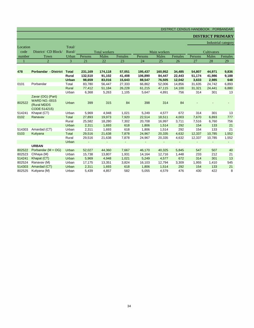
DISTRICT CENSUS HANDBOOK : PORBANDAR
DISTRICT PRIMARY
Persons Males Females Persons Males Females Persons Males Females
1 2 3 21 22 23 24 25 26 27 28 29
478 Porbandar - District Total 231,169 174,118 57,051 195,437 160,952 34,485 54,807 44,971 9,836
Rural 132,510 91,102 41,408 106,890 84,447 22,443 51,174 41,986 9,188
Urban 98,659 83,016 15,643 88,547 76,505 12,042 3,633 2,985 648
0101 Porbandar Total 83,780 56,447 27,333 66,862 52,006 14,856 31,635 24,742 6,893
Rural 77,412 51,184 26,228 61,215 47,115 14,100 31,321 24,441 6,880
Urban 6,368 5,263 1,105 5,647 4,891 756 314 301 13
802522
Zavar (OG) (Part)
WARD NO.-0015
(Rural MDDS
CODE:514215)
Urban 399 315 84 398 314 84 - - -
514241 Khapat (CT) Urban 5,969 4,948 1,021 5,249 4,577 672 314 301 13
0102 Ranavav Total 27,893 19,973 7,920 22,514 18,511 4,003 7,670 6,893 777
Rural 25,582 18,280 7,302 20,708 16,997 3,711 7,516 6,760 756
Urban 2,311 1,693 618 1,806 1,514 292 154 133 21
514303 Amardad (CT) Urban 2,311 1,693 618 1,806 1,514 292 154 133 21
0103 Kutiyana Total 29,516 21,638 7,878 24,967 20,335 4,632 12,337 10,785 1,552
Rural 29,516 21,638 7,878 24,967 20,335 4,632 12,337 10,785 1,552
Urban - - - - - - - - -
URBAN
802522 Porbandar (M + OG) Urban 52,027 44,360 7,667 46,170 40,325 5,845 547 507 40
802523 Chhaya (M) Urban 15,738 13,807 1,931 14,164 12,716 1,448 233 212 21
514241 Khapat (CT) Urban 5,969 4,948 1,021 5,249 4,577 672 314 301 13
802524 Ranavav (M) Urban 17,175 13,351 3,824 16,103 12,794 3,309 1,955 1,410 545
514303 Amardad (CT) Urban 2,311 1,693 618 1,806 1,514 292 154 133 21
802525 Kutiyana (M) Urban 5,439 4,857 582 5,055 4,579 476 430 422 8
Location
code
number
District/ CD Block/
Town
Total/
Rural/
Urban
Total workers Main workers
Industrial category
Cultivators
34

PRIMARY CENSUS ABSTRACT
CENSUS ABSTRACT
Persons Males Females Persons Males Females Persons Males Females
30 31 32 33 34 35 36 37 38 3 2
36,278 24,878 11,400 1,847 1,396 451 102,505 89,707 12,798 Total Porbandar - District
30,716 21,162 9,554 896 702 194 24,104 20,597 3,507 Rural
5,562 3,716 1,846 951 694 257 78,401 69,110 9,291 Urban
16,834 11,074 5,760 737 583 154 17,656 15,607 2,049 Total Porbandar
16,330 10,783 5,547 569 432 137 12,995 11,459 1,536 Rural
504 291 213 168 151 17 4,661 4,148 513 Urban
- - - - - - 398 314 84 Urban
Zavar (OG) (Part)
WARD NO.-0015
(Rural MDDS
CODE:514215)
504 291 213 168 151 17 4,263 3,834 429 Urban Khapat (CT)
6,682 4,680 2,002 198 160 38 7,964 6,778 1,186 Total Ranavav
6,114 4,300 1,814 183 146 37 6,895 5,791 1,104 Rural
568 380 188 15 14 1 1,069 987 82 Urban
568 380 188 15 14 1 1,069 987 82 Urban Amardad (CT)
8,272 6,079 2,193 144 124 20 4,214 3,347 867 Total Kutiyana
8,272 6,079 2,193 144 124 20 4,214 3,347 867 Rural
- - - - - - - - - Urban
URBAN
330 275 55 514 363 151 44,779 39,180 5,599 Urban Porbandar (M + OG)
184 142 42 50 36 14 13,697 12,326 1,371 Urban Chhaya (M)
504 291 213 168 151 17 4,263 3,834 429 Urban Khapat (CT)
2,737 1,566 1,171 62 37 25 11,349 9,781 1,568 Urban Ranavav (M)
568 380 188 15 14 1 1,069 987 82 Urban Amardad (CT)
1,239 1,062 177 142 93 49 3,244 3,002 242 Urban Kutiyana (M)
of main workers
Agricultural labourers Household industry workers Other workers
Total/
Rural/
Urban
District/ CD Block/
Town
35

DISTRICT CENSUS HANDBOOK : PORBANDAR
DISTRICT PRIMARY
Persons Males Females Persons Males Females Persons Males Females
1 2 3 39 40 41 42 43 44 45 46 47
478 Porbandar - District Total 35,732 13,166 22,566 10,895 2,221 8,674 12,686 3,495 9,191
Rural 25,620 6,655 18,965 10,573 2,085 8,488 11,445 2,973 8,472
Urban 10,112 6,511 3,601 322 136 186 1,241 522 719
0101 Porbandar Total 16,918 4,441 12,477 6,952 1,206 5,746 7,579 1,947 5,632
Rural 16,197 4,069 12,128 6,946 1,201 5,745 7,446 1,906 5,540
Urban 721 372 349 6 5 1 133 41 92
802522
Zavar (OG) (Part)
WARD NO.-0015
(Rural MDDS
CODE:514215)
Urban 1 1 - - - - - - -
514241 Khapat (CT) Urban 720 371 349 6 5 1 133 41 92
0102 Ranavav Total 5,379 1,462 3,917 1,667 327 1,340 2,485 646 1,839
Rural 4,874 1,283 3,591 1,632 321 1,311 2,141 542 1,599
Urban 505 179 326 35 6 29 344 104 240
514303 Amardad (CT) Urban 505 179 326 35 6 29 344 104 240
0103 Kutiyana Total 4,549 1,303 3,246 1,995 563 1,432 1,858 525 1,333
Rural 4,549 1,303 3,246 1,995 563 1,432 1,858 525 1,333
Urban - - - - - - - - -
URBAN
802522 Porbandar (M + OG) Urban 5,857 4,035 1,822 101 47 54 112 59 53
802523 Chhaya (M) Urban 1,574 1,091 483 34 24 10 76 33 43
514241 Khapat (CT) Urban 720 371 349 6 5 1 133 41 92
802524 Ranavav (M) Urban 1,072 557 515 99 46 53 379 123 256
514303 Amardad (CT) Urban 505 179 326 35 6 29 344 104 240
802525 Kutiyana (M) Urban 384 278 106 47 8 39 197 162 35
Marginal workers Cultivators
Location
code
number
District/ CD Block/
Town
Total/
Rural/
Urban
Industrial category
Agricultural labourers
36

PRIMARY CENSUS ABSTRACT
CENSUS ABSTRACT
Persons Males Females Persons Males Females Persons Males Females
48 49 50 51 52 53 54 55 56 3 2 1
524 198 326 11,627 7,252 4,375 354,280 126,091 228,189 Total Porbandar - District 478
251 89 162 3,351 1,508 1,843 167,265 62,158 105,107 Rural
273 109 164 8,276 5,744 2,532 187,015 63,933 123,082 Urban
281 92 189 2,106 1,196 910 101,411 38,360 63,051 Total Porbandar 0101
153 57 96 1,652 905 747 90,045 34,504 55,541 Rural
128 35 93 454 291 163 11,366 3,856 7,510 Urban
- - - 1 1 - 591 192 399 Urban
Zavar (OG) (Part)
WARD NO.-0015
(Rural MDDS
CODE:514215)
802522
128 35 93 453 290 163 10,775 3,664 7,111 Urban Khapat (CT) 514241
46 24 22 1,181 465 716 40,657 14,952 25,705 Total Ranavav 0102
33 20 13 1,068 400 668 37,096 13,631 23,465 Rural
13 4 9 113 65 48 3,561 1,321 2,240 Urban
13 4 9 113 65 48 3,561 1,321 2,240 Urban Amardad (CT) 514303
65 12 53 631 203 428 40,124 14,023 26,101 Total Kutiyana 0103
65 12 53 631 203 428 40,124 14,023 26,101 Rural
- - - - - - - - - Urban
URBAN
110 59 51 5,534 3,870 1,664 100,733 34,244 66,489 Urban Porbandar (M + OG) 802522
10 5 5 1,454 1,029 425 31,961 10,911 21,050 Urban Chhaya (M) 802523
128 35 93 453 290 163 10,775 3,664 7,111 Urban Khapat (CT) 514241
7 2 5 587 386 201 28,843 10,199 18,644 Urban Ranavav (M) 802524
13 4 9 113 65 48 3,561 1,321 2,240 Urban Amardad (CT) 514303
5 4 1 135 104 31 11,142 3,594 7,548 Urban Kutiyana (M) 802525
District/ CD Block/
Town
Location
code
number
Household industry workers Other workers Non-workers
of marginal workers
Total/
Rural/
Urban
37


Appendix to District Primary Census Abstract
Total, Scheduled Castes and Scheduled Tribes
Population - Urban Block wise

Location
Code
Name of Town Name of Ward Boundaries of Urban Block /
EB Number
Total
Population
Scheduled
Castes
Population
Scheduled
Tribes
Population
1 2 3 4 5 6 7
802522 Porbandar (M + OG) WARD No.-0001 EB No.-000100 707 9 3
802522 Porbandar (M + OG) WARD No.-0001 EB No.-000200 603 - -
802522 Porbandar (M + OG) WARD No.-0001 EB No.-000300 762 - -
802522 Porbandar (M + OG) WARD No.-0001 EB No.-000400 583 - -
802522 Porbandar (M + OG) WARD No.-0001 EB No.-000500 854 - -
802522 Porbandar (M + OG) WARD No.-0001 EB No.-000600 818 6 -
802522 Porbandar (M + OG) WARD No.-0001 EB No.-000700 624 272 -
802522 Porbandar (M + OG) WARD No.-0001 EB No.-000800 625 - -
802522 Porbandar (M + OG) WARD No.-0001 EB No.-000900 448 - -
802522 Porbandar (M + OG) WARD No.-0001 EB No.-001000 460 - -
802522 Porbandar (M + OG) WARD No.-0001 EB No.-0011 SUB-EB No.01 539 - -
802522 Porbandar (M + OG) WARD No.-0001 EB No.-0011 SUB-EB No.02 374 - -
802522 Porbandar (M + OG) WARD No.-0001 EB No.-001200 377 - -
802522 Porbandar (M + OG) WARD No.-0001 EB No.-001300 375 68 -
802522 Porbandar (M + OG) WARD No.-0001 EB No.-001400 304 4 -
802522 Porbandar (M + OG) WARD No.-0001 EB No.-001500 451 - 5
802522 Porbandar (M + OG) WARD No.-0001 EB No.-001600 455 9 -
802522 Porbandar (M + OG) WARD No.-0001 EB No.-001700 571 - -
802522 Porbandar (M + OG) WARD No.-0001 EB No.-001800 600 64 16
802522 Porbandar (M + OG) WARD No.-0001 EB No.-001900 627 - -
802522 Porbandar (M + OG) WARD No.-0001 EB No.-002000 624 - -
802522 Porbandar (M + OG) WARD No.-0001 EB No.-002100 332 - -
802522 Porbandar (M + OG) WARD No.-0001 EB No.-002200 429 200 -
802522 Porbandar (M + OG) WARD No.-0001 EB No.-0023 SUB-EB No.01 658 - -
802522 Porbandar (M + OG) WARD No.-0001 EB No.-0023 SUB-EB No.02 636 - -
802522 Porbandar (M + OG) WARD No.-0001 EB No.-0024 SUB-EB No.01 571 - -
802522 Porbandar (M + OG) WARD No.-0001 EB No.-0024 SUB-EB No.02 465 - -
802522 Porbandar (M + OG) WARD No.-0001 EB No.-0025 SUB-EB No.01 623 71 -
802522 Porbandar (M + OG) WARD No.-0001 EB No.-0025 SUB-EB No.02 458 - -
802522 Porbandar (M + OG) WARD No.-0001 EB No.-002600 726 91 -
802522 Porbandar (M + OG) WARD No.-0001 EB No.-002700 753 22 -
802522 Porbandar (M + OG) WARD No.-0001 EB No.-310100 121 - -
802522 Porbandar (M + OG) WARD No.-0002 EB No.-002800 638 566 -
802522 Porbandar (M + OG) WARD No.-0002 EB No.-002900 809 26 -
802522 Porbandar (M + OG) WARD No.-0002 EB No.-0030 SUB-EB No.01 527 526 -
802522 Porbandar (M + OG) WARD No.-0002 EB No.-0030 SUB-EB No.02 420 116 -
802522 Porbandar (M + OG) WARD No.-0002 EB No.-003100 735 - -
802522 Porbandar (M + OG) WARD No.-0002 EB No.-003200 675 674 -
802522 Porbandar (M + OG) WARD No.-0002 EB No.-003300 229 10 -
802522 Porbandar (M + OG) WARD No.-0002 EB No.-003400 478 4 18
802522 Porbandar (M + OG) WARD No.-0002 EB No.-003500 505 - 19
802522 Porbandar (M + OG) WARD No.-0002 EB No.-003600 315 1 -
802522 Porbandar (M + OG) WARD No.-0002 EB No.-003700 326 - -
802522 Porbandar (M + OG) WARD No.-0002 EB No.-003800 367 - -
802522 Porbandar (M + OG) WARD No.-0002 EB No.-003900 615 - -
APPENDIX TO DISTRICT PRIMARY CENSUS ABSTRACT TOTAL, SCHEDULED CASTES AND SCHEDULED TRIBES POPULATION - URBAN BLOCK WISE
40

Location
Code
Name of Town Name of Ward Boundaries of Urban Block /
EB Number
Total
Population
Scheduled
Castes
Population
Scheduled
Tribes
Population
1 2 3 4 5 6 7
APPENDIX TO DISTRICT PRIMARY CENSUS ABSTRACT TOTAL, SCHEDULED CASTES AND SCHEDULED TRIBES POPULATION - URBAN BLOCK WISE
802522 Porbandar (M + OG) WARD No.-0002 EB No.-004000 628 - -
802522 Porbandar (M + OG) WARD No.-0002 EB No.-004100 458 - -
802522 Porbandar (M + OG) WARD No.-0002 EB No.-004200 705 - -
802522 Porbandar (M + OG) WARD No.-0002 EB No.-0043 SUB-EB No.01 488 - -
802522 Porbandar (M + OG) WARD No.-0002 EB No.-0043 SUB-EB No.02 605 - -
802522 Porbandar (M + OG) WARD No.-0002 EB No.-004400 499 5 -
802522 Porbandar (M + OG) WARD No.-0003 EB No.-004500 210 7 -
802522 Porbandar (M + OG) WARD No.-0003 EB No.-004600 365 - -
802522 Porbandar (M + OG) WARD No.-0003 EB No.-0047 SUB-EB No.01 490 - -
802522 Porbandar (M + OG) WARD No.-0003 EB No.-0047 SUB-EB No.02 414 - -
802522 Porbandar (M + OG) WARD No.-0003 EB No.-004800 311 - -
802522 Porbandar (M + OG) WARD No.-0003 EB No.-004900 317 - -
802522 Porbandar (M + OG) WARD No.-0003 EB No.-005000 504 - -
802522 Porbandar (M + OG) WARD No.-0003 EB No.-005100 524 3 -
802522 Porbandar (M + OG) WARD No.-0003 EB No.-005200 265 1 -
802522 Porbandar (M + OG) WARD No.-0003 EB No.-005300 314 - -
802522 Porbandar (M + OG) WARD No.-0003 EB No.-005400 441 10 4
802522 Porbandar (M + OG) WARD No.-0003 EB No.-005500 450 - -
802522 Porbandar (M + OG) WARD No.-0003 EB No.-005600 260 - -
802522 Porbandar (M + OG) WARD No.-0003 EB No.-005700 491 - -
802522 Porbandar (M + OG) WARD No.-0003 EB No.-005800 292 - -
802522 Porbandar (M + OG) WARD No.-0003 EB No.-005900 59 - -
802522 Porbandar (M + OG) WARD No.-0003 EB No.-006000 428 - -
802522 Porbandar (M + OG) WARD No.-0003 EB No.-006100 602 - -
802522 Porbandar (M + OG) WARD No.-0003 EB No.-006200 435 - -
802522 Porbandar (M + OG) WARD No.-0003 EB No.-006300 343 4 -
802522 Porbandar (M + OG) WARD No.-0003 EB No.-006400 455 13 -
802522 Porbandar (M + OG) WARD No.-0003 EB No.-006500 440 - -
802522 Porbandar (M + OG) WARD No.-0003 EB No.-006600 454 - -
802522 Porbandar (M + OG) WARD No.-0003 EB No.-006700 765 - -
802522 Porbandar (M + OG) WARD No.-0003 EB No.-006800 466 - -
802522 Porbandar (M + OG) WARD No.-0004 EB No.-006900 433 216 -
802522 Porbandar (M + OG) WARD No.-0004 EB No.-007000 551 - -
802522 Porbandar (M + OG) WARD No.-0004 EB No.-007100 544 3 -
802522 Porbandar (M + OG) WARD No.-0004 EB No.-007200 467 - -
802522 Porbandar (M + OG) WARD No.-0004 EB No.-007300 519 - 27
802522 Porbandar (M + OG) WARD No.-0004 EB No.-007400 674 4 -
802522 Porbandar (M + OG) WARD No.-0004 EB No.-007500 478 - -
802522 Porbandar (M + OG) WARD No.-0004 EB No.-007600 619 - -
802522 Porbandar (M + OG) WARD No.-0004 EB No.-007700 458 - -
802522 Porbandar (M + OG) WARD No.-0004 EB No.-007800 661 5 -
802522 Porbandar (M + OG) WARD No.-0004 EB No.-007900 635 105 -
802522 Porbandar (M + OG) WARD No.-0004 EB No.-008000 572 - -
802522 Porbandar (M + OG) WARD No.-0004 EB No.-008100 511 - -
802522 Porbandar (M + OG) WARD No.-0004 EB No.-008200 834 2 1
41

Location
Code
Name of Town Name of Ward Boundaries of Urban Block /
EB Number
Total
Population
Scheduled
Castes
Population
Scheduled
Tribes
Population
1 2 3 4 5 6 7
APPENDIX TO DISTRICT PRIMARY CENSUS ABSTRACT TOTAL, SCHEDULED CASTES AND SCHEDULED TRIBES POPULATION - URBAN BLOCK WISE
802522 Porbandar (M + OG) WARD No.-0004 EB No.-008300 411 - -
802522 Porbandar (M + OG) WARD No.-0004 EB No.-008400 296 - -
802522 Porbandar (M + OG) WARD No.-0004 EB No.-008500 658 - -
802522 Porbandar (M + OG) WARD No.-0004 EB No.-008600 374 - -
802522 Porbandar (M + OG) WARD No.-0004 EB No.-008700 404 - -
802522 Porbandar (M + OG) WARD No.-0004 EB No.-008800 450 - 5
802522 Porbandar (M + OG) WARD No.-0004 EB No.-008900 500 - -
802522 Porbandar (M + OG) WARD No.-0005 EB No.-009000 660 51 -
802522 Porbandar (M + OG) WARD No.-0005 EB No.-009100 742 - -
802522 Porbandar (M + OG) WARD No.-0005 EB No.-009200 339 - -
802522 Porbandar (M + OG) WARD No.-0005 EB No.-009300 408 - -
802522 Porbandar (M + OG) WARD No.-0005 EB No.-009400 339 - -
802522 Porbandar (M + OG) WARD No.-0005 EB No.-009500 415 - -
802522 Porbandar (M + OG) WARD No.-0005 EB No.-009600 381 - -
802522 Porbandar (M + OG) WARD No.-0005 EB No.-009700 824 558 -
802522 Porbandar (M + OG) WARD No.-0005 EB No.-009800 409 408 -
802522 Porbandar (M + OG) WARD No.-0005 EB No.-009900 312 311 -
802522 Porbandar (M + OG) WARD No.-0005 EB No.-010000 482 473 3
802522 Porbandar (M + OG) WARD No.-0005 EB No.-0101 SUB-EB No.01 471 323 1
802522 Porbandar (M + OG) WARD No.-0005 EB No.-0101 SUB-EB No.02 470 457 -
802522 Porbandar (M + OG) WARD No.-0005 EB No.-010200 697 - -
802522 Porbandar (M + OG) WARD No.-0005 EB No.-010300 654 205 -
802522 Porbandar (M + OG) WARD No.-0005 EB No.-010400 397 - 36
802522 Porbandar (M + OG) WARD No.-0005 EB No.-010500 705 19 30
802522 Porbandar (M + OG) WARD No.-0005 EB No.-010600 778 26 -
802522 Porbandar (M + OG) WARD No.-0005 EB No.-010700 619 - -
802522 Porbandar (M + OG) WARD No.-0005 EB No.-010800 558 187 -
802522 Porbandar (M + OG) WARD No.-0005 EB No.-010900 171 - -
802522 Porbandar (M + OG) WARD No.-0005 EB No.-011000 298 - -
802522 Porbandar (M + OG) WARD No.-0005 EB No.-011100 472 56 -
802522 Porbandar (M + OG) WARD No.-0006 EB No.-011200 752 - -
802522 Porbandar (M + OG) WARD No.-0006 EB No.-011300 525 - -
802522 Porbandar (M + OG) WARD No.-0006 EB No.-011400 382 - -
802522 Porbandar (M + OG) WARD No.-0006 EB No.-011500 394 - -
802522 Porbandar (M + OG) WARD No.-0006 EB No.-011600 347 - 10
802522 Porbandar (M + OG) WARD No.-0006 EB No.-011700 610 - -
802522 Porbandar (M + OG) WARD No.-0006 EB No.-011800 595 - -
802522 Porbandar (M + OG) WARD No.-0006 EB No.-011900 357 - 4
802522 Porbandar (M + OG) WARD No.-0006 EB No.-012000 456 19 -
802522 Porbandar (M + OG) WARD No.-0006 EB No.-012100 590 17 -
802522 Porbandar (M + OG) WARD No.-0006 EB No.-012200 460 1 6
802522 Porbandar (M + OG) WARD No.-0006 EB No.-012300 665 - -
802522 Porbandar (M + OG) WARD No.-0006 EB No.-012400 249 - -
802522 Porbandar (M + OG) WARD No.-0006 EB No.-012500 590 1 130
802522 Porbandar (M + OG) WARD No.-0006 EB No.-012600 539 - -
42

Location
Code
Name of Town Name of Ward Boundaries of Urban Block /
EB Number
Total
Population
Scheduled
Castes
Population
Scheduled
Tribes
Population
1 2 3 4 5 6 7
APPENDIX TO DISTRICT PRIMARY CENSUS ABSTRACT TOTAL, SCHEDULED CASTES AND SCHEDULED TRIBES POPULATION - URBAN BLOCK WISE
802522 Porbandar (M + OG) WARD No.-0006 EB No.-012700 534 - -
802522 Porbandar (M + OG) WARD No.-0006 EB No.-012800 580 - -
802522 Porbandar (M + OG) WARD No.-0006 EB No.-012900 383 6 -
802522 Porbandar (M + OG) WARD No.-0006 EB No.-013000 570 3 41
802522 Porbandar (M + OG) WARD No.-0006 EB No.-013100 355 - -
802522 Porbandar (M + OG) WARD No.-0007 EB No.-013200 564 - -
802522 Porbandar (M + OG) WARD No.-0007 EB No.-013300 631 - -
802522 Porbandar (M + OG) WARD No.-0007 EB No.-013400 374 - -
802522 Porbandar (M + OG) WARD No.-0007 EB No.-013500 381 - -
802522 Porbandar (M + OG) WARD No.-0007 EB No.-013600 450 - -
802522 Porbandar (M + OG) WARD No.-0007 EB No.-013700 515 - -
802522 Porbandar (M + OG) WARD No.-0007 EB No.-013800 175 4 5
802522 Porbandar (M + OG) WARD No.-0007 EB No.-013900 221 7 -
802522 Porbandar (M + OG) WARD No.-0007 EB No.-014000 103 - -
802522 Porbandar (M + OG) WARD No.-0007 EB No.-014100 375 - 18
802522 Porbandar (M + OG) WARD No.-0007 EB No.-014200 741 - 6
802522 Porbandar (M + OG) WARD No.-0007 EB No.-014300 852 - -
802522 Porbandar (M + OG) WARD No.-0007 EB No.-014400 649 - 14
802522 Porbandar (M + OG) WARD No.-0007 EB No.-014500 544 4 -
802522 Porbandar (M + OG) WARD No.-0007 EB No.-014600 525 4 -
802522 Porbandar (M + OG) WARD No.-0007 EB No.-014700 520 - -
802522 Porbandar (M + OG) WARD No.-0007 EB No.-014800 466 - -
802522 Porbandar (M + OG) WARD No.-0007 EB No.-014900 486 - 30
802522 Porbandar (M + OG) WARD No.-0007 EB No.-015000 519 - -
802522 Porbandar (M + OG) WARD No.-0007 EB No.-015100 448 30 24
802522 Porbandar (M + OG) WARD No.-0007 EB No.-015200 536 3 2
802522 Porbandar (M + OG) WARD No.-0007 EB No.-015300 511 - -
802522 Porbandar (M + OG) WARD No.-0007 EB No.-015400 485 39 8
802522 Porbandar (M + OG) WARD No.-0008 EB No.-015500 453 - -
802522 Porbandar (M + OG) WARD No.-0008 EB No.-015600 401 - -
802522 Porbandar (M + OG) WARD No.-0008 EB No.-015700 195 - -
802522 Porbandar (M + OG) WARD No.-0008 EB No.-015800 397 - -
802522 Porbandar (M + OG) WARD No.-0008 EB No.-015900 402 1 -
802522 Porbandar (M + OG) WARD No.-0008 EB No.-016000 343 - -
802522 Porbandar (M + OG) WARD No.-0008 EB No.-016100 209 32 4
802522 Porbandar (M + OG) WARD No.-0008 EB No.-016200 522 - -
802522 Porbandar (M + OG) WARD No.-0008 EB No.-016300 269 - -
802522 Porbandar (M + OG) WARD No.-0008 EB No.-016400 354 - -
802522 Porbandar (M + OG) WARD No.-0008 EB No.-016500 496 - -
802522 Porbandar (M + OG) WARD No.-0008 EB No.-016600 384 - -
802522 Porbandar (M + OG) WARD No.-0008 EB No.-016700 328 - -
802522 Porbandar (M + OG) WARD No.-0008 EB No.-016800 499 - -
802522 Porbandar (M + OG) WARD No.-0008 EB No.-0169 SUB-EB No.01 360 - -
802522 Porbandar (M + OG) WARD No.-0008 EB No.-0169 SUB-EB No.02 469 - -
802522 Porbandar (M + OG) WARD No.-0008 EB No.-017000 489 - -
43

Location
Code
Name of Town Name of Ward Boundaries of Urban Block /
EB Number
Total
Population
Scheduled
Castes
Population
Scheduled
Tribes
Population
1 2 3 4 5 6 7
APPENDIX TO DISTRICT PRIMARY CENSUS ABSTRACT TOTAL, SCHEDULED CASTES AND SCHEDULED TRIBES POPULATION - URBAN BLOCK WISE
802522 Porbandar (M + OG) WARD No.-0008 EB No.-017100 812 - -
802522 Porbandar (M + OG) WARD No.-0008 EB No.-017200 283 5 -
802522 Porbandar (M + OG) WARD No.-0009 EB No.-017300 460 - -
802522 Porbandar (M + OG) WARD No.-0009 EB No.-017400 606 - -
802522 Porbandar (M + OG) WARD No.-0009 EB No.-017500 519 - -
802522 Porbandar (M + OG) WARD No.-0009 EB No.-017600 395 - -
802522 Porbandar (M + OG) WARD No.-0009 EB No.-017700 504 - -
802522 Porbandar (M + OG) WARD No.-0009 EB No.-017800 322 - -
802522 Porbandar (M + OG) WARD No.-0009 EB No.-017900 331 - -
802522 Porbandar (M + OG) WARD No.-0009 EB No.-018000 561 - -
802522 Porbandar (M + OG) WARD No.-0009 EB No.-018100 592 - -
802522 Porbandar (M + OG) WARD No.-0009 EB No.-018200 431 - -
802522 Porbandar (M + OG) WARD No.-0009 EB No.-018300 57 - -
802522 Porbandar (M + OG) WARD No.-0009 EB No.-018400 482 68 -
802522 Porbandar (M + OG) WARD No.-0009 EB No.-018500 776 599 -
802522 Porbandar (M + OG) WARD No.-0009 EB No.-018600 657 - -
802522 Porbandar (M + OG) WARD No.-0009 EB No.-018700 297 - -
802522 Porbandar (M + OG) WARD No.-0009 EB No.-0188 SUB-EB No.01 613 14 -
802522 Porbandar (M + OG) WARD No.-0009 EB No.-0188 SUB-EB No.02 485 40 -
802522 Porbandar (M + OG) WARD No.-0009 EB No.-018900 476 464 -
802522 Porbandar (M + OG) WARD No.-0009 EB No.-019000 239 238 -
802522 Porbandar (M + OG) WARD No.-0010 EB No.-019100 461 - -
802522 Porbandar (M + OG) WARD No.-0010 EB No.-019200 719 - -
802522 Porbandar (M + OG) WARD No.-0010 EB No.-019300 205 - -
802522 Porbandar (M + OG) WARD No.-0010 EB No.-019400 654 - -
802522 Porbandar (M + OG) WARD No.-0010 EB No.-0195 SUB-EB No.01 563 - -
802522 Porbandar (M + OG) WARD No.-0010 EB No.-0195 SUB-EB No.02 424 - -
802522 Porbandar (M + OG) WARD No.-0010 EB No.-0196 SUB-EB No.01 515 - -
802522 Porbandar (M + OG) WARD No.-0010 EB No.-0196 SUB-EB No.02 636 - -
802522 Porbandar (M + OG) WARD No.-0010 EB No.-0197 SUB-EB No.01 684 - -
802522 Porbandar (M + OG) WARD No.-0010 EB No.-0197 SUB-EB No.02 696 - -
802522 Porbandar (M + OG) WARD No.-0010 EB No.-019800 800 - -
802522 Porbandar (M + OG) WARD No.-0010 EB No.-019900 485 - -
802522 Porbandar (M + OG) WARD No.-0010 EB No.-020000 507 - -
802522 Porbandar (M + OG) WARD No.-0010 EB No.-020100 499 - -
802522 Porbandar (M + OG) WARD No.-0010 EB No.-020200 447 - -
802522 Porbandar (M + OG) WARD No.-0010 EB No.-020300 436 - -
802522 Porbandar (M + OG) WARD No.-0010 EB No.-020400 695 - -
802522 Porbandar (M + OG) WARD No.-0010 EB No.-020500 398 - -
802522 Porbandar (M + OG) WARD No.-0011 EB No.-020600 603 - -
802522 Porbandar (M + OG) WARD No.-0011 EB No.-020700 424 - -
802522 Porbandar (M + OG) WARD No.-0011 EB No.-020800 442 - -
802522 Porbandar (M + OG) WARD No.-0011 EB No.-020900 566 - -
802522 Porbandar (M + OG) WARD No.-0011 EB No.-021000 474 - -
802522 Porbandar (M + OG) WARD No.-0011 EB No.-021100 453 - -
44

Location
Code
Name of Town Name of Ward Boundaries of Urban Block /
EB Number
Total
Population
Scheduled
Castes
Population
Scheduled
Tribes
Population
1 2 3 4 5 6 7
APPENDIX TO DISTRICT PRIMARY CENSUS ABSTRACT TOTAL, SCHEDULED CASTES AND SCHEDULED TRIBES POPULATION - URBAN BLOCK WISE
802522 Porbandar (M + OG) WARD No.-0011 EB No.-021200 397 - -
802522 Porbandar (M + OG) WARD No.-0011 EB No.-021300 544 - -
802522 Porbandar (M + OG) WARD No.-0011 EB No.-021400 366 - -
802522 Porbandar (M + OG) WARD No.-0011 EB No.-021500 383 - -
802522 Porbandar (M + OG) WARD No.-0011 EB No.-021600 238 - -
802522 Porbandar (M + OG) WARD No.-0011 EB No.-021700 532 - -
802522 Porbandar (M + OG) WARD No.-0011 EB No.-021800 569 - -
802522 Porbandar (M + OG) WARD No.-0011 EB No.-021900 391 - -
802522 Porbandar (M + OG) WARD No.-0011 EB No.-022000 681 - -
802522 Porbandar (M + OG) WARD No.-0011 EB No.-022100 768 - -
802522 Porbandar (M + OG) WARD No.-0011 EB No.-022200 383 - -
802522 Porbandar (M + OG) WARD No.-0011 EB No.-022300 445 - -
802522 Porbandar (M + OG) WARD No.-0012 EB No.-022400 384 - -
802522 Porbandar (M + OG) WARD No.-0012 EB No.-022500 413 - -
802522 Porbandar (M + OG) WARD No.-0012 EB No.-022600 523 - -
802522 Porbandar (M + OG) WARD No.-0012 EB No.-022700 459 - -
802522 Porbandar (M + OG) WARD No.-0012 EB No.-022800 469 - -
802522 Porbandar (M + OG) WARD No.-0012 EB No.-022900 474 - -
802522 Porbandar (M + OG) WARD No.-0012 EB No.-023000 365 - -
802522 Porbandar (M + OG) WARD No.-0012 EB No.-023100 369 - -
802522 Porbandar (M + OG) WARD No.-0012 EB No.-023200 379 - -
802522 Porbandar (M + OG) WARD No.-0012 EB No.-023300 526 - -
802522 Porbandar (M + OG) WARD No.-0012 EB No.-023400 528 - -
802522 Porbandar (M + OG) WARD No.-0012 EB No.-023500 180 - -
802522 Porbandar (M + OG) WARD No.-0012 EB No.-023600 272 - -
802522 Porbandar (M + OG) WARD No.-0012 EB No.-023700 273 - -
802522 Porbandar (M + OG) WARD No.-0012 EB No.-023800 561 - -
802522 Porbandar (M + OG) WARD No.-0012 EB No.-023900 564 - -
802522 Porbandar (M + OG) WARD No.-0012 EB No.-024000 734 - -
802522 Porbandar (M + OG) WARD No.-0012 EB No.-024100 533 - -
802522 Porbandar (M + OG) WARD No.-0012 EB No.-024200 285 - -
802522 Porbandar (M + OG) WARD No.-0012 EB No.-024300 452 - -
802522 Porbandar (M + OG) WARD No.-0012 EB No.-024400 313 - -
802522 Porbandar (M + OG) WARD No.-0012 EB No.-024500 340 - -
802522 Porbandar (M + OG) WARD No.-0012 EB No.-024600 341 - -
802522 Porbandar (M + OG) WARD No.-0012 EB No.-024700 440 - -
802522 Porbandar (M + OG) WARD No.-0013 EB No.-024800 475 - -
802522 Porbandar (M + OG) WARD No.-0013 EB No.-024900 297 - -
802522 Porbandar (M + OG) WARD No.-0013 EB No.-025000 556 - -
802522 Porbandar (M + OG) WARD No.-0013 EB No.-025100 293 - -
802522 Porbandar (M + OG) WARD No.-0013 EB No.-025200 557 - -
802522 Porbandar (M + OG) WARD No.-0013 EB No.-025300 383 - -
802522 Porbandar (M + OG) WARD No.-0013 EB No.-025400 206 - 6
802522 Porbandar (M + OG) WARD No.-0013 EB No.-025500 914 53 4
802522 Porbandar (M + OG) WARD No.-0013 EB No.-025600 609 - -
45

Location
Code
Name of Town Name of Ward Boundaries of Urban Block /
EB Number
Total
Population
Scheduled
Castes
Population
Scheduled
Tribes
Population
1 2 3 4 5 6 7
APPENDIX TO DISTRICT PRIMARY CENSUS ABSTRACT TOTAL, SCHEDULED CASTES AND SCHEDULED TRIBES POPULATION - URBAN BLOCK WISE
802522 Porbandar (M + OG) WARD No.-0013 EB No.-025700 795 - -
802522 Porbandar (M + OG) WARD No.-0013 EB No.-025800 340 - 12
802522 Porbandar (M + OG) WARD No.-0013 EB No.-025900 513 7 -
802522 Porbandar (M + OG) WARD No.-0013 EB No.-026000 953 127 8
802522 Porbandar (M + OG) WARD No.-0013 EB No.-026100 413 - -
802522 Porbandar (M + OG) WARD No.-0013 EB No.-026200 535 - -
802522 Porbandar (M + OG) WARD No.-0013 EB No.-026300 797 - -
802522 Porbandar (M + OG) WARD No.-0013 EB No.-026400 820 - 1
802522 Porbandar (M + OG) WARD No.-0013 EB No.-026500 312 11 5
802522 Porbandar (M + OG) WARD No.-0014 EB No.-026600 670 36 8
802522 Porbandar (M + OG) WARD No.-0014 EB No.-026700 538 10 -
802522 Porbandar (M + OG) WARD No.-0014 EB No.-026800 660 - -
802522 Porbandar (M + OG) WARD No.-0014 EB No.-0269 SUB-EB No.01 472 4 -
802522 Porbandar (M + OG) WARD No.-0014 EB No.-0269 SUB-EB No.02 486 - -
802522 Porbandar (M + OG) WARD No.-0014 EB No.-0270 SUB-EB No.01 574 - 233
802522 Porbandar (M + OG) WARD No.-0014 EB No.-0270 SUB-EB No.02 455 - -
802522 Porbandar (M + OG) WARD No.-0014 EB No.-027100 594 - -
802522 Porbandar (M + OG) WARD No.-0014 EB No.-027200 679 - 23
802522 Porbandar (M + OG) WARD No.-0014 EB No.-027300 700 - 54
802522 Porbandar (M + OG) WARD No.-0014 EB No.-027400 943 - -
802522 Porbandar (M + OG) WARD No.-0014 EB No.-027500 469 - -
802522 Porbandar (M + OG) WARD No.-0014 EB No.-027600 886 - -
802522 Porbandar (M + OG) WARD No.-0014 EB No.-0277 SUB-EB No.01 631 - 3
802522 Porbandar (M + OG) WARD No.-0014 EB No.-0277 SUB-EB No.02 523 - -
802522 Porbandar (M + OG) WARD No.-0014 EB No.-027800 577 - -
802522 Porbandar (M + OG) WARD No.-0014 EB No.-027900 824 - 49
802522 Porbandar (M + OG) WARD No.-0014 EB No.-0280 SUB-EB No.01 480 - -
802522 Porbandar (M + OG) WARD No.-0014 EB No.-0280 SUB-EB No.02 488 - 6
802522 Porbandar (M + OG) WARD No.-0014 EB No.-028100 636 10 12
802522 Porbandar (M + OG) WARD No.-0014 EB No.-028200 386 3 107
802522 Porbandar (M + OG) WARD No.-0014 EB No.-028300 358 - 4
802522 Porbandar (M + OG) WARD No.-0014 EB No.-028400 369 - -
802522 Porbandar (M + OG) WARD No.-0014 EB No.-028500 448 - -
802522 Porbandar (M + OG) WARD No.-0014 EB No.-028600 295 - -
802522 Porbandar (M + OG) WARD No.-0014 EB No.-028700 503 - -
802522 Porbandar (M + OG) WARD No.-0014 EB No.-028800 413 - -
802522 Porbandar (M + OG) WARD No.-0014 EB No.-028900 493 73 -
802522 Porbandar (M + OG) WARD No.-0015 EB No.-029000 644 6 -
802522 Porbandar (M + OG) WARD No.-0015 EB No.-029100 346 - -
802523 Chhaya (M) WARD No.-0001 EB No.-000100 279 54 -
802523 Chhaya (M) WARD No.-0001 EB No.-000200 294 - -
802523 Chhaya (M) WARD No.-0001 EB No.-000300 390 34 -
802523 Chhaya (M) WARD No.-0001 EB No.-000400 543 22 -
802523 Chhaya (M) WARD No.-0001 EB No.-000500 348 - 4
802523 Chhaya (M) WARD No.-0001 EB No.-000600 287 4 -
46

Location
Code
Name of Town Name of Ward Boundaries of Urban Block /
EB Number
Total
Population
Scheduled
Castes
Population
Scheduled
Tribes
Population
1 2 3 4 5 6 7
APPENDIX TO DISTRICT PRIMARY CENSUS ABSTRACT TOTAL, SCHEDULED CASTES AND SCHEDULED TRIBES POPULATION - URBAN BLOCK WISE
802523 Chhaya (M) WARD No.-0002 EB No.-000700 524 - -
802523 Chhaya (M) WARD No.-0002 EB No.-000800 600 - -
802523 Chhaya (M) WARD No.-0002 EB No.-000900 800 - 32
802523 Chhaya (M) WARD No.-0002 EB No.-001000 819 - 10
802523 Chhaya (M) WARD No.-0002 EB No.-001100 634 - -
802523 Chhaya (M) WARD No.-0002 EB No.-001200 573 4 4
802523 Chhaya (M) WARD No.-0002 EB No.-001300 654 - -
802523 Chhaya (M) WARD No.-0002 EB No.-001400 701 - -
802523 Chhaya (M) WARD No.-0003 EB No.-001500 748 - -
802523 Chhaya (M) WARD No.-0003 EB No.-001600 625 4 -
802523 Chhaya (M) WARD No.-0003 EB No.-001700 561 - -
802523 Chhaya (M) WARD No.-0003 EB No.-001800 767 - -
802523 Chhaya (M) WARD No.-0003 EB No.-0019 SUB-EB No.01 559 - -
802523 Chhaya (M) WARD No.-0003 EB No.-0019 SUB-EB No.02 490 - -
802523 Chhaya (M) WARD No.-0003 EB No.-002000 645 - -
802523 Chhaya (M) WARD No.-0003 EB No.-002100 620 4 -
802523 Chhaya (M) WARD No.-0004 EB No.-002200 687 - -
802523 Chhaya (M) WARD No.-0004 EB No.-002300 486 - -
802523 Chhaya (M) WARD No.-0004 EB No.-002400 678 - -
802523 Chhaya (M) WARD No.-0004 EB No.-0025 SUB-EB No.01 458 - -
802523 Chhaya (M) WARD No.-0004 EB No.-0025 SUB-EB No.02 470 - -
802523 Chhaya (M) WARD No.-0004 EB No.-002600 706 - -
802523 Chhaya (M) WARD No.-0004 EB No.-002700 694 - -
802523 Chhaya (M) WARD No.-0005 EB No.-002800 684 - -
802523 Chhaya (M) WARD No.-0005 EB No.-002900 733 39 -
802523 Chhaya (M) WARD No.-0005 EB No.-003000 577 - -
802523 Chhaya (M) WARD No.-0005 EB No.-003100 748 - -
802523 Chhaya (M) WARD No.-0006 EB No.-003200 724 3 -
802523 Chhaya (M) WARD No.-0006 EB No.-003300 863 - -
802523 Chhaya (M) WARD No.-0006 EB No.-003400 695 692 -
802523 Chhaya (M) WARD No.-0006 EB No.-003500 607 593 -
802523 Chhaya (M) WARD No.-0006 EB No.-003600 454 449 -
802523 Chhaya (M) WARD No.-0006 EB No.-003700 748 746 -
802523 Chhaya (M) WARD No.-0006 EB No.-003800 795 526 3
802523 Chhaya (M) WARD No.-0006 EB No.-003900 496 488 4
802523 Chhaya (M) WARD No.-0006 EB No.-004000 592 78 -
802523 Chhaya (M) WARD No.-0006 EB No.-004100 489 185 -
802523 Chhaya (M) WARD No.-0007 EB No.-004200 530 7 -
802523 Chhaya (M) WARD No.-0007 EB No.-004300 685 9 -
802523 Chhaya (M) WARD No.-0007 EB No.-004400 744 - -
802523 Chhaya (M) WARD No.-0007 EB No.-004500 792 - 259
802523 Chhaya (M) WARD No.-0007 EB No.-004600 739 1 15
802523 Chhaya (M) WARD No.-0007 EB No.-004700 739 - 133
802523 Chhaya (M) WARD No.-0007 EB No.-004800 326 1 -
802523 Chhaya (M) WARD No.-0008 EB No.-004900 567 - -
47

Location
Code
Name of Town Name of Ward Boundaries of Urban Block /
EB Number
Total
Population
Scheduled
Castes
Population
Scheduled
Tribes
Population
1 2 3 4 5 6 7
APPENDIX TO DISTRICT PRIMARY CENSUS ABSTRACT TOTAL, SCHEDULED CASTES AND SCHEDULED TRIBES POPULATION - URBAN BLOCK WISE
802523 Chhaya (M) WARD No.-0008 EB No.-005000 839 - 1
802523 Chhaya (M) WARD No.-0008 EB No.-005100 788 - -
802523 Chhaya (M) WARD No.-0008 EB No.-005200 877 - -
802523 Chhaya (M) WARD No.-0008 EB No.-005300 662 17 -
802523 Chhaya (M) WARD No.-0008 EB No.-005400 807 - -
802523 Chhaya (M) WARD No.-0008 EB No.-005500 373 - 17
802523 Chhaya (M) WARD No.-0008 EB No.-005600 621 - -
802523 Chhaya (M) WARD No.-0008 EB No.-005700 732 - -
802523 Chhaya (M) WARD No.-0008 EB No.-005800 544 23 24
802523 Chhaya (M) WARD No.-0009 EB No.-006000 603 - 207
802523 Chhaya (M) WARD No.-0009 EB No.-006100 637 334 -
802523 Chhaya (M) WARD No.-0009 EB No.-006200 752 746 -
802523 Chhaya (M) WARD No.-0009 EB No.-006300 662 5 11
802523 Chhaya (M) WARD No.-0009 EB No.-006400 655 2 -
802523 Chhaya (M) WARD No.-0009 EB No.-006500 612 - 71
802523 Chhaya (M) WARD No.-0009 EB No.-006600 448 4 1
802523 Chhaya (M) WARD No.-0009 EB No.-006700 562 8 -
802523 Chhaya (M) WARD No.-0009 EB No.-006800 585 15 26
802523 Chhaya (M) WARD No.-0009 EB No.-006900 399 - 4
802523 Chhaya (M) WARD No.-0009 EB No.-007000 490 28 9
802523 Chhaya (M) WARD No.-0009 EB No.-007100 571 - 16
802523 Chhaya (M) WARD No.-0009 EB No.-007200 667 - 6
802523 Chhaya (M) WARD No.-0009 EB No.-007300 437 18 9
802523 Chhaya (M) WARD No.-0009 EB No.-007400 406 22 -
802523 Chhaya (M) WARD No.-0009 EB No.-007500 464 - -
802523 Chhaya (M) WARD No.-0009 EB No.-007600 601 9 -
802523 Chhaya (M) WARD No.-0009 EB No.-0077 SUB-EB No.01 696 - -
802523 Chhaya (M) WARD No.-0009 EB No.-0077 SUB-EB No.02 212 - -
802523 Chhaya (M) WARD No.-0009 EB No.-310100 30 - -
514241 Khapat (CT) WARD No.-0001 EB No.-000100 545 - -
514241 Khapat (CT) WARD No.-0001 EB No.-000200 865 - -
514241 Khapat (CT) WARD No.-0001 EB No.-000300 625 - -
514241 Khapat (CT) WARD No.-0001 EB No.-000400 904 11 -
514241 Khapat (CT) WARD No.-0001 EB No.-000500 900 560 -
514241 Khapat (CT) WARD No.-0001 EB No.-000600 822 117 143
514241 Khapat (CT) WARD No.-0001 EB No.-0007 SUB-EB No.01 833 8 26
514241 Khapat (CT) WARD No.-0001 EB No.-0007 SUB-EB No.02 260 12 -
514241 Khapat (CT) WARD No.-0001 EB No.-000800 977 17 -
514241 Khapat (CT) WARD No.-0001 EB No.-000900 1022 - -
514241 Khapat (CT) WARD No.-0001 EB No.-001000 825 87 -
514241 Khapat (CT) WARD No.-0001 EB No.-0011 SUB-EB No.01 701 55 -
514241 Khapat (CT) WARD No.-0001 EB No.-0011 SUB-EB No.02 241 - -
514241 Khapat (CT) WARD No.-0001 EB No.-001200 743 234 -
514241 Khapat (CT) WARD No.-0001 EB No.-001300 816 460 30
514241 Khapat (CT) WARD No.-0001 EB No.-001400 791 15 -
48

Location
Code
Name of Town Name of Ward Boundaries of Urban Block /
EB Number
Total
Population
Scheduled
Castes
Population
Scheduled
Tribes
Population
1 2 3 4 5 6 7
APPENDIX TO DISTRICT PRIMARY CENSUS ABSTRACT TOTAL, SCHEDULED CASTES AND SCHEDULED TRIBES POPULATION - URBAN BLOCK WISE
514241 Khapat (CT) WARD No.-0001 EB No.-001500 746 4 -
514241 Khapat (CT) WARD No.-0001 EB No.-001600 830 26 4
514241 Khapat (CT) WARD No.-0001 EB No.-001700 794 12 4
514241 Khapat (CT) WARD No.-0001 EB No.-001800 797 37 -
514241 Khapat (CT) WARD No.-0001 EB No.-001900 970 - -
514241 Khapat (CT) WARD No.-0001 EB No.-002000 737 - -
802524 Ranavav (M) WARD No.-0001 EB No.-000100 362 - -
802524 Ranavav (M) WARD No.-0001 EB No.-000200 347 - -
802524 Ranavav (M) WARD No.-0001 EB No.-000300 335 - -
802524 Ranavav (M) WARD No.-0001 EB No.-000400 349 - -
802524 Ranavav (M) WARD No.-0001 EB No.-000500 545 545 -
802524 Ranavav (M) WARD No.-0001 EB No.-000600 354 110 -
802524 Ranavav (M) WARD No.-0001 EB No.-000700 691 - 5
802524 Ranavav (M) WARD No.-0001 EB No.-000800 920 - 4
802524 Ranavav (M) WARD No.-0002 EB No.-000900 534 - -
802524 Ranavav (M) WARD No.-0002 EB No.-001000 719 549 -
802524 Ranavav (M) WARD No.-0002 EB No.-001100 723 - -
802524 Ranavav (M) WARD No.-0002 EB No.-001200 619 - -
802524 Ranavav (M) WARD No.-0002 EB No.-001300 791 - 33
802524 Ranavav (M) WARD No.-0002 EB No.-0014 SUB-EB No.01 465 - 26
802524 Ranavav (M) WARD No.-0002 EB No.-0014 SUB-EB No.02 480 - 28
802524 Ranavav (M) WARD No.-0002 EB No.-001500 663 - 38
802524 Ranavav (M) WARD No.-0003 EB No.-001600 461 - 19
802524 Ranavav (M) WARD No.-0003 EB No.-001700 752 9 -
802524 Ranavav (M) WARD No.-0003 EB No.-0018 SUB-EB No.01 592 541 -
802524 Ranavav (M) WARD No.-0003 EB No.-0018 SUB-EB No.02 615 551 -
802524 Ranavav (M) WARD No.-0003 EB No.-001900 836 62 34
802524 Ranavav (M) WARD No.-0003 EB No.-002000 896 - 7
802524 Ranavav (M) WARD No.-0004 EB No.-002100 904 - 78
802524 Ranavav (M) WARD No.-0004 EB No.-0022 SUB-EB No.01 451 - 78
802524 Ranavav (M) WARD No.-0004 EB No.-0022 SUB-EB No.02 434 377 2
802524 Ranavav (M) WARD No.-0004 EB No.-0023 SUB-EB No.01 481 21 14
802524 Ranavav (M) WARD No.-0004 EB No.-0023 SUB-EB No.02 380 14 -
802524 Ranavav (M) WARD No.-0004 EB No.-0024 SUB-EB No.01 641 10 6
802524 Ranavav (M) WARD No.-0004 EB No.-0024 SUB-EB No.02 720 - 41
802524 Ranavav (M) WARD No.-0004 EB No.-002500 699 30 -
802524 Ranavav (M) WARD No.-0004 EB No.-002600 666 442 -
802524 Ranavav (M) WARD No.-0005 EB No.-002700 771 - -
802524 Ranavav (M) WARD No.-0005 EB No.-002800 857 8 12
802524 Ranavav (M) WARD No.-0005 EB No.-002900 684 - -
802524 Ranavav (M) WARD No.-0005 EB No.-0030 SUB-EB No.01 502 10 -
802524 Ranavav (M) WARD No.-0005 EB No.-0030 SUB-EB No.02 585 8 28
802524 Ranavav (M) WARD No.-0005 EB No.-003100 913 7 -
802524 Ranavav (M) WARD No.-0006 EB No.-003200 649 - -
802524 Ranavav (M) WARD No.-0006 EB No.-003300 698 270 -
49

Location
Code
Name of Town Name of Ward Boundaries of Urban Block /
EB Number
Total
Population
Scheduled
Castes
Population
Scheduled
Tribes
Population
1 2 3 4 5 6 7
APPENDIX TO DISTRICT PRIMARY CENSUS ABSTRACT TOTAL, SCHEDULED CASTES AND SCHEDULED TRIBES POPULATION - URBAN BLOCK WISE
802524 Ranavav (M) WARD No.-0006 EB No.-003400 790 - 77
802524 Ranavav (M) WARD No.-0006 EB No.-003500 844 2 -
802524 Ranavav (M) WARD No.-0006 EB No.-003600 691 - -
802524 Ranavav (M) WARD No.-0006 EB No.-003700 598 - -
802524 Ranavav (M) WARD No.-0006 EB No.-003800 615 - -
802524 Ranavav (M) WARD No.-0006 EB No.-003900 779 7 -
802524 Ranavav (M) WARD No.-0007 EB No.-004000 656 - -
802524 Ranavav (M) WARD No.-0007 EB No.-0041 SUB-EB No.01 437 - -
802524 Ranavav (M) WARD No.-0007 EB No.-0041 SUB-EB No.02 491 - -
802524 Ranavav (M) WARD No.-0007 EB No.-004200 555 14 -
802524 Ranavav (M) WARD No.-0007 EB No.-0043 SUB-EB No.01 560 135 -
802524 Ranavav (M) WARD No.-0007 EB No.-0043 SUB-EB No.02 508 355 -
802524 Ranavav (M) WARD No.-0007 EB No.-004400 845 644 -
802524 Ranavav (M) WARD No.-0007 EB No.-004500 608 - -
802524 Ranavav (M) WARD No.-0008 EB No.-004600 690 - -
802524 Ranavav (M) WARD No.-0008 EB No.-004700 573 - -
802524 Ranavav (M) WARD No.-0008 EB No.-004800 419 - -
802524 Ranavav (M) WARD No.-0008 EB No.-004900 574 - -
802524 Ranavav (M) WARD No.-0008 EB No.-005000 781 - 177
802524 Ranavav (M) WARD No.-0008 EB No.-0051 SUB-EB No.01 480 - 30
802524 Ranavav (M) WARD No.-0008 EB No.-0051 SUB-EB No.02 471 - -
802524 Ranavav (M) WARD No.-0008 EB No.-005200 669 - -
802524 Ranavav (M) WARD No.-0009 EB No.-005300 946 19 1
802524 Ranavav (M) WARD No.-0009 EB No.-0054 SUB-EB No.01 452 - -
802524 Ranavav (M) WARD No.-0009 EB No.-0054 SUB-EB No.02 636 8 -
802524 Ranavav (M) WARD No.-0009 EB No.-0055 SUB-EB No.01 487 - -
802524 Ranavav (M) WARD No.-0009 EB No.-0055 SUB-EB No.02 420 - 10
802524 Ranavav (M) WARD No.-0009 EB No.-0056 SUB-EB No.01 533 - -
802524 Ranavav (M) WARD No.-0009 EB No.-0056 SUB-EB No.02 447 - -
802524 Ranavav (M) WARD No.-0009 EB No.-0057 SUB-EB No.01 703 - -
802524 Ranavav (M) WARD No.-0009 EB No.-0057 SUB-EB No.02 604 - -
802524 Ranavav (M) WARD No.-0009 EB No.-0058 SUB-EB No.01 380 - 13
802524 Ranavav (M) WARD No.-0009 EB No.-0058 SUB-EB No.02 484 - 11
802524 Ranavav (M) WARD No.-0010 EB No.-005900 578 - -
802524 Ranavav (M) WARD No.-0010 EB No.-006000 713 - -
802524 Ranavav (M) WARD No.-0010 EB No.-006100 556 - -
802524 Ranavav (M) WARD No.-0010 EB No.-006200 361 44 -
514303 Amardad (CT) WARD No.-0001 EB No.-000100 747 - -
514303 Amardad (CT) WARD No.-0001 EB No.-000200 560 - -
514303 Amardad (CT) WARD No.-0001 EB No.-000300 499 304 -
514303 Amardad (CT) WARD No.-0001 EB No.-000400 579 - -
514303 Amardad (CT) WARD No.-0001 EB No.-000500 386 29 5
514303 Amardad (CT) WARD No.-0001 EB No.-000600 630 501 -
514303 Amardad (CT) WARD No.-0001 EB No.-000700 688 44 3
514303 Amardad (CT) WARD No.-0001 EB No.-000800 556 26 134
50

Location
Code
Name of Town Name of Ward Boundaries of Urban Block /
EB Number
Total
Population
Scheduled
Castes
Population
Scheduled
Tribes
Population
1 2 3 4 5 6 7
APPENDIX TO DISTRICT PRIMARY CENSUS ABSTRACT TOTAL, SCHEDULED CASTES AND SCHEDULED TRIBES POPULATION - URBAN BLOCK WISE
514303 Amardad (CT) WARD No.-0001 EB No.-000900 520 - 72
514303 Amardad (CT) WARD No.-0001 EB No.-001000 707 361 -
802525 Kutiyana (M) WARD No.-0001 EB No.-000100 532 5 -
802525 Kutiyana (M) WARD No.-0001 EB No.-000200 462 23 -
802525 Kutiyana (M) WARD No.-0001 EB No.-000300 528 - -
802525 Kutiyana (M) WARD No.-0001 EB No.-000400 654 6 -
802525 Kutiyana (M) WARD No.-0001 EB No.-000500 537 - 7
802525 Kutiyana (M) WARD No.-0001 EB No.-000600 491 - -
802525 Kutiyana (M) WARD No.-0001 EB No.-000700 649 30 4
802525 Kutiyana (M) WARD No.-0002 EB No.-000800 440 - -
802525 Kutiyana (M) WARD No.-0002 EB No.-000900 454 200 -
802525 Kutiyana (M) WARD No.-0002 EB No.-001000 458 457 -
802525 Kutiyana (M) WARD No.-0002 EB No.-001100 515 515 -
802525 Kutiyana (M) WARD No.-0002 EB No.-001200 435 120 4
802525 Kutiyana (M) WARD No.-0002 EB No.-001300 280 52 -
802525 Kutiyana (M) WARD No.-0003 EB No.-001400 765 - -
802525 Kutiyana (M) WARD No.-0003 EB No.-001500 830 15 -
802525 Kutiyana (M) WARD No.-0003 EB No.-001600 349 - -
802525 Kutiyana (M) WARD No.-0004 EB No.-001700 316 - -
802525 Kutiyana (M) WARD No.-0004 EB No.-001800 826 - -
802525 Kutiyana (M) WARD No.-0004 EB No.-001900 624 - -
802525 Kutiyana (M) WARD No.-0004 EB No.-002000 480 - 4
802525 Kutiyana (M) WARD No.-0005 EB No.-002100 507 3 9
802525 Kutiyana (M) WARD No.-0005 EB No.-002200 625 5 -
802525 Kutiyana (M) WARD No.-0005 EB No.-002300 572 36 -
802525 Kutiyana (M) WARD No.-0005 EB No.-002400 257 10 -
802525 Kutiyana (M) WARD No.-0006 EB No.-002500 672 - -
802525 Kutiyana (M) WARD No.-0006 EB No.-002600 388 17 -
802525 Kutiyana (M) WARD No.-0006 EB No.-002700 543 5 -
802525 Kutiyana (M) WARD No.-0006 EB No.-002800 438 - -
802525 Kutiyana (M) WARD No.-0007 EB No.-002900 294 16 -
802525 Kutiyana (M) WARD No.-0007 EB No.-003000 385 - -
802525 Kutiyana (M) WARD No.-0007 EB No.-003100 463 - 2
802525 Kutiyana (M) WARD No.-0007 EB No.-003200 340 - -
802525 Kutiyana (M) WARD No.-0007 EB No.-003300 472 231 -
51


Primary Census Abstract for
Scheduled Castes (SC)

DISTRICT CENSUS HANDBOOK : PORBANDAR
PRIMARY CENSUS ABSTRACT
Persons Males Females Persons Males Females
1 2 3 4 5 6 7 8 9 10
478 Porbandar - District Total 11,087 51,830 26,607 25,223 5,920 3,029 2,891
Rural 6,280 29,068 14,955 14,113 3,407 1,737 1,670
Urban 4,807 22,762 11,652 11,110 2,513 1,292 1,221
0101 Porbandar Total 3,713 17,194 8,867 8,327 1,979 1,025 954
Rural 3,355 15,533 8,029 7,504 1,783 938 845
Urban 358 1,661 838 823 196 87 109
0102 Ranavav Total 1,304 5,904 3,020 2,884 642 321 321
Rural 1,015 4,639 2,367 2,272 541 261 280
Urban 289 1,265 653 612 101 60 41
0103 Kutiyana Total 1,910 8,896 4,559 4,337 1,083 538 545
Rural 1,910 8,896 4,559 4,337 1,083 538 545
Urban - - - - - - -
URBAN
802522 Porbandar (M + OG) Urban 1,695 8,130 4,097 4,033 839 444 395
802523 Chhaya (M) Urban 1,091 5,174 2,663 2,511 598 315 283
514241 Khapat (CT) Urban 357 1,655 834 821 196 87 109
802524 Ranavav (M) Urban 1,015 4,792 2,509 2,283 579 294 285
514303 Amardad (CT) Urban 289 1,265 653 612 101 60 41
802525 Kutiyana (M) Urban 360 1,746 896 850 200 92 108
Location
code
number
District/ CD Block/
Town
Total/
Rural/
Urban
Number of
households
with SC as
head
Total population (including institutional
and houseless population) Population in the age-group 0-6
54

PRIMARY CENSUS ABSTRACT
FOR SCHEDULED CASTES
Persons Males Females Persons Males Females Persons Males Females
11 12 13 14 15 16 17 18 19 3 2
33,518 19,671 13,847 18,312 6,936 11,376 21,839 15,646 6,193 Total Porbandar - District
18,137 10,872 7,265 10,931 4,083 6,848 13,348 9,005 4,343 Rural
15,381 8,799 6,582 7,381 2,853 4,528 8,491 6,641 1,850 Urban
10,619 6,367 4,252 6,575 2,500 4,075 8,194 5,289 2,905 Total Porbandar
9,593 5,776 3,817 5,940 2,253 3,687 7,523 4,802 2,721 Rural
1,026 591 435 635 247 388 671 487 184 Urban
3,865 2,290 1,575 2,039 730 1,309 2,430 1,731 699 Total Ranavav
2,946 1,747 1,199 1,693 620 1,073 1,906 1,361 545 Rural
919 543 376 346 110 236 524 370 154 Urban
5,598 3,349 2,249 3,298 1,210 2,088 3,919 2,842 1,077 Total Kutiyana
5,598 3,349 2,249 3,298 1,210 2,088 3,919 2,842 1,077 Rural
- - - - - - - - - Urban
URBAN
5,684 3,128 2,556 2,446 969 1,477 2,817 2,272 545 Urban Porbandar (M + OG)
3,615 2,093 1,522 1,559 570 989 1,897 1,524 373 Urban Chhaya (M)
1,021 587 434 634 247 387 667 485 182 Urban Khapat (CT)
2,964 1,768 1,196 1,828 741 1,087 2,036 1,499 537 Urban Ranavav (M)
919 543 376 346 110 236 524 370 154 Urban Amardad (CT)
1,178 680 498 568 216 352 550 491 59 Urban Kutiyana (M)
District/ CD Block/
Town
Total/
Rural/
Urban
Total workersLiterates Illiterates
55

DISTRICT CENSUS HANDBOOK : PORBANDAR
PRIMARY CENSUS ABSTRACT
Persons Males Females Persons Males Females Persons Males Females
1 2 3 20 21 22 23 24 25 26 27 28
478 Porbandar - District Total 18,055 14,078 3,977 360 293 67 8,884 6,404 2,480
Rural 10,685 8,116 2,569 342 281 61 8,022 5,885 2,137
Urban 7,370 5,962 1,408 18 12 6 862 519 343
0101 Porbandar Total 6,322 4,618 1,704 161 120 41 4,093 2,789 1,304
Rural 5,709 4,156 1,553 161 120 41 4,062 2,767 1,295
Urban 613 462 151 - - - 31 22 9
0102 Ranavav Total 1,980 1,588 392 37 28 9 1,455 1,138 317
Rural 1,605 1,285 320 37 28 9 1,317 1,047 270
Urban 375 303 72 - - - 138 91 47
0103 Kutiyana Total 3,371 2,675 696 144 133 11 2,643 2,071 572
Rural 3,371 2,675 696 144 133 11 2,643 2,071 572
Urban - - - - - - - - -
URBAN
802522 Porbandar (M + OG) Urban 2,426 2,027 399 6 3 3 17 13 4
802523 Chhaya (M) Urban 1,538 1,287 251 5 4 1 46 30 16
514241 Khapat (CT) Urban 609 460 149 - - - 31 22 9
802524 Ranavav (M) Urban 1,911 1,428 483 7 5 2 460 215 245
514303 Amardad (CT) Urban 375 303 72 - - - 138 91 47
802525 Kutiyana (M) Urban 511 457 54 - - - 170 148 22
CultivatorsMain workers
Location
code
number
District/ CD Block/
Town
Total/
Rural/
Urban
Industrial category
Agricultural labourers
56

PRIMARY CENSUS ABSTRACT
FOR SCHEDULED CASTES
Persons Males Females Persons Males Females Persons Males Females
29 30 31 32 33 34 35 36 37 3 2
246 151 95 8,565 7,230 1,335 3,784 1,568 2,216 Total Porbandar - District
209 122 87 2,112 1,828 284 2,663 889 1,774 Rural
37 29 8 6,453 5,402 1,051 1,121 679 442 Urban
205 119 86 1,863 1,590 273 1,872 671 1,201 Total Porbandar
205 119 86 1,281 1,150 131 1,814 646 1,168 Rural
- - - 582 440 142 58 25 33 Urban
3 2 1 485 420 65 450 143 307 Total Ranavav
1 1 - 250 209 41 301 76 225 Rural
2 1 1 235 211 24 149 67 82 Urban
3 2 1 581 469 112 548 167 381 Total Kutiyana
3 2 1 581 469 112 548 167 381 Rural
- - - - - - - - - Urban
URBAN
24 19 5 2,379 1,992 387 391 245 146 Urban Porbandar (M + OG)
4 3 1 1,483 1,250 233 359 237 122 Urban Chhaya (M)
- - - 578 438 140 58 25 33 Urban Khapat (CT)
3 2 1 1,441 1,206 235 125 71 54 Urban Ranavav (M)
2 1 1 235 211 24 149 67 82 Urban Amardad (CT)
4 4 - 337 305 32 39 34 5 Urban Kutiyana (M)
Household industry workers Marginal workers
Total/
Rural/
Urban
District/ CD Block/
Town
of main workers
Other workers
57
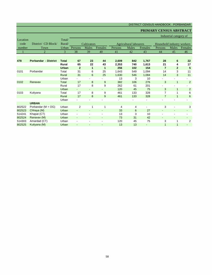
DISTRICT CENSUS HANDBOOK : PORBANDAR
PRIMARY CENSUS ABSTRACT
Persons Males Females Persons Males Females Persons Males Females
1 2 3 38 39 40 41 42 43 44 45 46
478 Porbandar - District Total 67 23 44 2,609 842 1,767 28 6 22
Rural 65 22 43 2,353 740 1,613 21 4 17
Urban 2 1 1 256 102 154 7 2 5
0101 Porbandar Total 31 6 25 1,643 549 1,094 14 3 11
Rural 31 6 25 1,630 546 1,084 14 3 11
Urban - - - 13 3 10 - - -
0102 Ranavav Total 17 8 9 382 106 276 3 1 2
Rural 17 8 9 262 61 201 - - -
Urban - - - 120 45 75 3 1 2
0103 Kutiyana Total 17 8 9 461 133 328 7 1 6
Rural 17 8 9 461 133 328 7 1 6
Urban - - - - - - - - -
URBAN
802522 Porbandar (M + OG) Urban 2 1 1 4 4 - 3 - 3
802523 Chhaya (M) Urban - - - 33 6 27 - - -
514241 Khapat (CT) Urban - - - 13 3 10 - - -
802524 Ranavav (M) Urban - - - 73 31 42 - - -
514303 Amardad (CT) Urban - - - 120 45 75 3 1 2
802525 Kutiyana (M) Urban - - - 13 13 - 1 1 -
Location
code
number
District/ CD Block/
Town
Total/
Rural/
Urban
Agricultural labourers
Industrial category of
Cultivators Household industry workers
58

PRIMARY CENSUS ABSTRACT
FOR SCHEDULED CASTES
Persons Males Females Persons Males Females
47 48 49 50 51 52 3 2 1
1,080 697 383 29,991 10,961 19,030 Total Porbandar - District 478
224 123 101 15,720 5,950 9,770 Rural
856 574 282 14,271 5,011 9,260 Urban
184 113 71 9,000 3,578 5,422 Total Porbandar 0101
139 91 48 8,010 3,227 4,783 Rural
45 22 23 990 351 639 Urban
48 28 20 3,474 1,289 2,185 Total Ranavav 0102
22 7 15 2,733 1,006 1,727 Rural
26 21 5 741 283 458 Urban
63 25 38 4,977 1,717 3,260 Total Kutiyana 0103
63 25 38 4,977 1,717 3,260 Rural
- - - - - - Urban
URBAN
382 240 142 5,313 1,825 3,488 Urban Porbandar (M + OG) 802522
326 231 95 3,277 1,139 2,138 Urban Chhaya (M) 802523
45 22 23 988 349 639 Urban Khapat (CT) 514241
52 40 12 2,756 1,010 1,746 Urban Ranavav (M) 802524
26 21 5 741 283 458 Urban Amardad (CT) 514303
25 20 5 1,196 405 791 Urban Kutiyana (M) 802525
Non-workers
Total/
Rural/
Urban
marginal workers
District/ CD Block/
Town
Location
code
number
Other workers
59


Primary Census Abstract for
Scheduled Tribes (ST)

DISTRICT CENSUS HANDBOOK : PORBANDAR
PRIMARY CENSUS ABSTRACT
Persons Males Females Persons Males Females
1 2 3 4 5 6 7 8 9 10
478 Porbandar - District Total 2,299 13,039 6,730 6,309 2,286 1,187 1,099
Rural 1,755 9,945 5,146 4,799 1,787 945 842
Urban 544 3,094 1,584 1,510 499 242 257
0101 Porbandar Total 797 4,612 2,421 2,191 809 412 397
Rural 762 4,405 2,310 2,095 767 391 376
Urban 35 207 111 96 42 21 21
0102 Ranavav Total 951 5,346 2,727 2,619 995 541 454
Rural 911 5,132 2,625 2,507 952 520 432
Urban 40 214 102 112 43 21 22
0103 Kutiyana Total 82 408 211 197 68 34 34
Rural 82 408 211 197 68 34 34
Urban - - - - - - -
URBAN
802522 Porbandar (M + OG) Urban 179 1,005 519 486 124 61 63
802523 Chhaya (M) Urban 152 866 429 437 167 79 88
514241 Khapat (CT) Urban 35 207 111 96 42 21 21
802524 Ranavav (M) Urban 129 772 405 367 118 58 60
514303 Amardad (CT) Urban 40 214 102 112 43 21 22
802525 Kutiyana (M) Urban 9 30 18 12 5 2 3
Location
code
number
District/ CD Block/
Town
Total/
Rural/
Urban
Number of
households
with ST as
head
Total population (including institutional
and houseless population) Population in the age-group 0-6
62
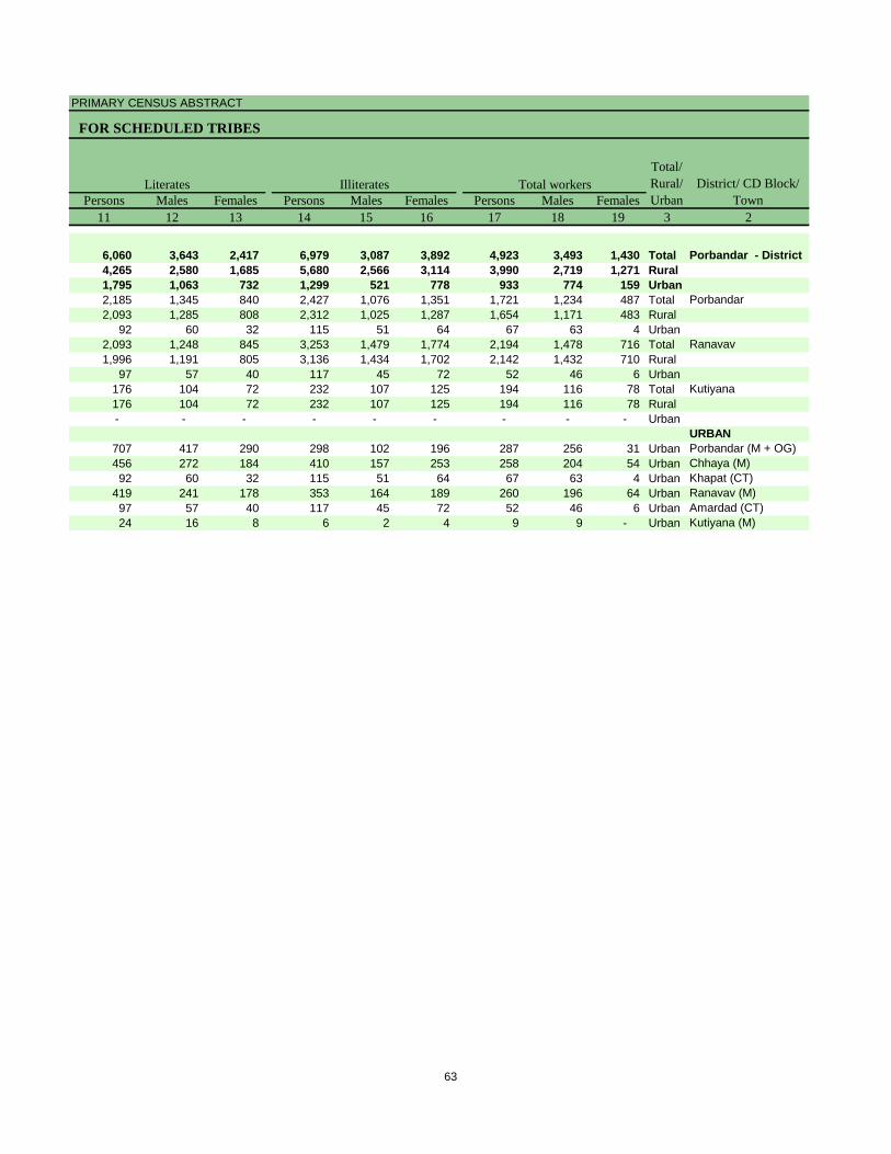
PRIMARY CENSUS ABSTRACT
FOR SCHEDULED TRIBES
Persons Males Females Persons Males Females Persons Males Females
11 12 13 14 15 16 17 18 19 3 2
6,060 3,643 2,417 6,979 3,087 3,892 4,923 3,493 1,430 Total Porbandar - District
4,265 2,580 1,685 5,680 2,566 3,114 3,990 2,719 1,271 Rural
1,795 1,063 732 1,299 521 778 933 774 159 Urban
2,185 1,345 840 2,427 1,076 1,351 1,721 1,234 487 Total Porbandar
2,093 1,285 808 2,312 1,025 1,287 1,654 1,171 483 Rural
92 60 32 115 51 64 67 63 4 Urban
2,093 1,248 845 3,253 1,479 1,774 2,194 1,478 716 Total Ranavav
1,996 1,191 805 3,136 1,434 1,702 2,142 1,432 710 Rural
97 57 40 117 45 72 52 46 6 Urban
176 104 72 232 107 125 194 116 78 Total Kutiyana
176 104 72 232 107 125 194 116 78 Rural
- - - - - - - - - Urban
URBAN
707 417 290 298 102 196 287 256 31 Urban Porbandar (M + OG)
456 272 184 410 157 253 258 204 54 Urban Chhaya (M)
92 60 32 115 51 64 67 63 4 Urban Khapat (CT)
419 241 178 353 164 189 260 196 64 Urban Ranavav (M)
97 57 40 117 45 72 52 46 6 Urban Amardad (CT)
24 16 8 6 2 4 9 9 - Urban Kutiyana (M)
District/ CD Block/
Town
Total/
Rural/
Urban
Total workersLiterates Illiterates
63

DISTRICT CENSUS HANDBOOK : PORBANDAR
PRIMARY CENSUS ABSTRACT
Persons Males Females Persons Males Females Persons Males Females
1 2 3 20 21 22 23 24 25 26 27 28
478 Porbandar - District Total 3,841 3,167 674 520 449 71 1,155 781 374
Rural 2,991 2,440 551 501 436 65 1,079 729 350
Urban 850 727 123 19 13 6 76 52 24
0101 Porbandar Total 1,329 1,127 202 240 220 20 441 300 141
Rural 1,268 1,069 199 239 219 20 439 298 141
Urban 61 58 3 1 1 - 2 2 -
0102 Ranavav Total 1,638 1,319 319 224 183 41 568 390 178
Rural 1,587 1,273 314 223 182 41 561 383 178
Urban 51 46 5 1 1 - 7 7 -
0103 Kutiyana Total 136 98 38 39 35 4 79 48 31
Rural 136 98 38 39 35 4 79 48 31
Urban - - - - - - - - -
URBAN
802522 Porbandar (M + OG) Urban 265 240 25 1 1 - 2 1 1
802523 Chhaya (M) Urban 219 186 33 1 1 - - - -
514241 Khapat (CT) Urban 61 58 3 1 1 - 2 2 -
802524 Ranavav (M) Urban 247 190 57 14 8 6 65 42 23
514303 Amardad (CT) Urban 51 46 5 1 1 - 7 7 -
802525 Kutiyana (M) Urban 7 7 - 1 1 - - - -
District/ CD Block/
Town
Total/
Rural/
Urban
Industrial category
Agricultural labourersMain workers
Location
code
number
Cultivators
64

PRIMARY CENSUS ABSTRACT
FOR SCHEDULED TRIBES
Persons Males Females Persons Males Females Persons Males Females
29 30 31 32 33 34 35 36 37 3 2
33 20 13 2,133 1,917 216 1,082 326 756 Total Porbandar - District
24 12 12 1,387 1,263 124 999 279 720 Rural
9 8 1 746 654 92 83 47 36 Urban
4 4 - 644 603 41 392 107 285 Total Porbandar
4 4 - 586 548 38 386 102 284 Rural
- - - 58 55 3 6 5 1 Urban
20 8 12 826 738 88 556 159 397 Total Ranavav
20 8 12 783 700 83 555 159 396 Rural
- - - 43 38 5 1 - 1 Urban
- - - 18 15 3 58 18 40 Total Kutiyana
- - - 18 15 3 58 18 40 Rural
- - - - - - - - - Urban
URBAN
9 8 1 253 230 23 22 16 6 Urban Porbandar (M + OG)
- - - 218 185 33 39 18 21 Urban Chhaya (M)
- - - 58 55 3 6 5 1 Urban Khapat (CT)
- - - 168 140 28 13 6 7 Urban Ranavav (M)
- - - 43 38 5 1 - 1 Urban Amardad (CT)
- - - 6 6 - 2 2 - Urban Kutiyana (M)
of main workers
Other workersHousehold industry workers Marginal workers
Total/
Rural/
Urban
District/ CD Block/
Town
65

DISTRICT CENSUS HANDBOOK : PORBANDAR
PRIMARY CENSUS ABSTRACT
Persons Males Females Persons Males Females Persons Males Females
1 2 3 38 39 40 41 42 43 44 45 46
478 Porbandar - District Total 185 39 146 495 160 335 3 2 1
Rural 184 39 145 481 156 325 3 2 1
Urban 1 - 1 14 4 10 - - -
0101 Porbandar Total 125 32 93 202 45 157 2 1 1
Rural 125 32 93 201 45 156 2 1 1
Urban - - - 1 - 1 - - -
0102 Ranavav Total 57 7 50 244 100 144 1 1 -
Rural 57 7 50 243 100 143 1 1 -
Urban - - - 1 - 1 - - -
0103 Kutiyana Total 2 - 2 37 11 26 - - -
Rural 2 - 2 37 11 26 - - -
Urban - - - - - - - - -
URBAN
802522 Porbandar (M + OG) Urban 1 - 1 1 - 1 - - -
802523 Chhaya (M) Urban - - - 1 - 1 - - -
514241 Khapat (CT) Urban - - - 1 - 1 - - -
802524 Ranavav (M) Urban - - - 10 4 6 - - -
514303 Amardad (CT) Urban - - - 1 - 1 - - -
802525 Kutiyana (M) Urban - - - - - - - - -
Cultivators Household industry workers
Location
code
number
District/ CD Block/
Town
Total/
Rural/
Urban
Agricultural labourers
Industrial category of
66

PRIMARY CENSUS ABSTRACT
FOR SCHEDULED TRIBES
Persons Males Females Persons Males Females
47 48 49 50 51 52 3 2 1
399 125 274 8,116 3,237 4,879 Total Porbandar - District 478
331 82 249 5,955 2,427 3,528 Rural
68 43 25 2,161 810 1,351 Urban
63 29 34 2,891 1,187 1,704 Total Porbandar 0101
58 24 34 2,751 1,139 1,612 Rural
5 5 - 140 48 92 Urban
254 51 203 3,152 1,249 1,903 Total Ranavav 0102
254 51 203 2,990 1,193 1,797 Rural
- - - 162 56 106 Urban
19 7 12 214 95 119 Total Kutiyana 0103
19 7 12 214 95 119 Rural
- - - - - - Urban
URBAN
20 16 4 718 263 455 Urban Porbandar (M + OG) 802522
38 18 20 608 225 383 Urban Chhaya (M) 802523
5 5 - 140 48 92 Urban Khapat (CT) 514241
3 2 1 512 209 303 Urban Ranavav (M) 802524
- - - 162 56 106 Urban Amardad (CT) 514303
2 2 - 21 9 12 Urban Kutiyana (M) 802525
District/ CD Block/
Town
Location
code
number
Other workers Non-workers
Total/
Rural/
Urban
marginal workers
67


Rural PCA-C.D. blocks wise
Village Primary Census
Abstract

DISTRICT CENSUS HANDBOOK : PORBANDAR
VILLAGE PRIMARY
Persons Males Females Persons Males Females
1 2 3 4 5 6 7 8 9 10
0101 Porbandar (Total) 107,532.17 38,977 185,191 94,807 90,384 22,013 11,498 10,515
0101 Porbandar (Rural) 106,838.17 35,074 167,457 85,688 81,769 19,952 10,445 9,507
0101 Porbandar (Urban) 694.00 3,903 17,734 9,119 8,615 2,061 1,053 1,008
RURAL
514167 Bhetkadi 953.31 300 1,297 653 644 142 66 76
514168 Advana 3,272.00 1,234 5,736 2,909 2,827 629 334 295
514169 Simar 1,304.74 491 2,145 1,090 1,055 213 110 103
514170 Rojhivada 1,521.68 495 2,215 1,125 1,090 255 125 130
514171 Ishvariya 591.17 213 1,062 526 536 147 75 72
514172 Bhomiyavadar 1,186.47 390 1,719 865 854 228 106 122
514173 Sodhana 1,623.61 754 3,317 1,673 1,644 302 145 157
514174 Shingda 1,859.45 543 2,453 1,241 1,212 280 134 146
514175 Sisli 1,096.04 414 1,798 921 877 201 122 79
514176 Miyani 0.00 630 3,239 1,644 1,595 583 299 284
514177 Bhavpara 4,390.16 441 1,915 957 958 230 110 120
514178 Vadala 1,726.43 446 1,916 995 921 164 91 73
514179 Ambarama 1,858.50 271 1,209 618 591 144 78 66
514180 Fatana 1,843.51 784 3,623 1,886 1,737 400 215 185
514181 Majivana 969.07 208 1,027 541 486 96 39 57
514182 Kunvadar 806.96 339 1,597 827 770 186 94 92
514183 Morana 732.42 230 1,037 538 499 103 50 53
514184 Paravada 921.43 355 1,729 905 824 200 101 99
514185 Nagka 793.41 458 2,180 1,116 1,064 290 157 133
514186 Bavalvav 423.40 70 356 182 174 32 17 15
514187 Natvarnagar 471.67 102 432 234 198 48 24 24
514188 Khambhodar 1,373.78 547 2,617 1,340 1,277 298 172 126
514189 Kindar Kheda 1,967.05 340 1,594 816 778 164 76 88
514190 Modhvada 2,151.05 927 4,540 2,271 2,269 496 246 250
514191 Sakhpur 770.62 151 686 338 348 66 39 27
514192 Tukda Miyani 1,237.14 391 1,924 972 952 228 118 110
514193 Visavada 2,717.62 787 3,470 1,768 1,702 357 205 152
514194 Palkhada 1,573.86 251 1,190 631 559 102 59 43
514195 Keshav 1,489.76 164 763 387 376 91 47 44
514196 Bagvadar 504.83 557 2,507 1,317 1,190 304 163 141
514197 Vachhoda 339.00 123 554 294 260 55 35 20
514198 Khistri 350.09 154 710 371 339 74 41 33
514199 Vinjhrana 452.66 247 1,084 540 544 128 60 68
514200 Godhana 690.81 167 897 434 463 121 54 67
514201 Katvana 697.87 312 1,577 838 739 214 124 90
514202 Beran 336.69 204 858 429 429 100 45 55
514203 Bharvada 2,754.16 477 2,115 1,120 995 266 150 116
514204 Baradiya 877.80 76 344 181 163 43 22 21
514205 Ratdi 602.79 390 1,815 912 903 246 123 123
514206 Kantela 939.38 259 1,289 654 635 165 80 85
514207 Shrinagar 809.76 190 1,141 598 543 151 78 73
514208 Rinavada 972.79 176 877 459 418 125 67 58
514209 Simani 333.26 151 702 362 340 80 44 36
514210 Bakharla 2,797.68 1,000 4,779 2,458 2,321 490 254 236
514211 Boricha 1,009.99 358 1,788 921 867 230 118 112
514212 Pandavadar 1,141.59 175 776 422 354 88 52 36
514213 Degam 1,305.28 935 4,454 2,291 2,163 553 286 267
514214 Kuchhdi 3,254.69 933 4,348 2,196 2,152 526 275 251
514215 Zaver (Part) 88.71 147 634 318 316 76 29 47
514216 Kolikhada 796.44 550 2,868 1,484 1,384 444 227 217
514217 Ratanpar 1,733.29 293 1,243 646 597 129 81 48
514218 Oddar 3,074.69 1,107 5,379 2,808 2,571 693 387 306
Name of Village
Location
code
number
Total population (including
institutional and houseless
population)
Area of
Village in
hectares
Number of
households
C D Block -
Population in the age-group 0-6
70

PRIMARY CENSUS ABSTRACT
CENSUS ABSTRACTPorbandar
Persons Males Females Persons Males Females Persons Males Females
11 12 13 14 15 16 17 18 19 2
17,194 8,867 8,327 4,612 2,421 2,191 113,872 65,612 48,260 Porbandar (Total)
15,533 8,029 7,504 4,405 2,310 2,095 101,929 58,946 42,983 Porbandar (Rural)
1,661 838 823 207 111 96 11,943 6,666 5,277 Porbandar (Urban)
RURAL
57 32 25 15 8 7 774 442 332 Bhetkadi
89 44 45 14 6 8 3,678 2,042 1,636 Advana
61 26 35 17 9 8 1,444 826 618 Simar
182 93 89 - - - 1,398 806 592 Rojhivada
4 3 1 - - - 638 362 276 Ishvariya
61 35 26 61 33 28 1,094 634 460 Bhomiyavadar
738 366 372 14 8 6 2,216 1,271 945 Sodhana
502 248 254 111 49 62 1,546 883 663 Shingda
41 22 19 7 5 2 1,112 633 479 Sisli
129 67 62 - - - 1,584 976 608 Miyani
23 12 11 45 24 21 1,166 667 499 Bhavpara
256 138 118 - - - 1,293 761 532 Vadala
47 24 23 8 5 3 766 435 331 Ambarama
856 462 394 148 77 71 2,295 1,370 925 Fatana
128 70 58 - - - 697 423 274 Majivana
169 81 88 7 4 3 1,081 626 455 Kunvadar
106 52 54 - - - 654 376 278 Morana
222 122 100 3 2 1 1,133 651 482 Paravada
47 26 21 10 6 4 1,196 664 532 Nagka
35 20 15 - - - 235 134 101 Bavalvav
- - - - - - 282 176 106 Natvarnagar
97 50 47 70 40 30 1,717 940 777 Khambhodar
100 49 51 - - - 1,072 624 448 Kindar Kheda
482 249 233 - - - 2,971 1,659 1,312 Modhvada
22 12 10 - - - 472 253 219 Sakhpur
154 78 76 11 7 4 1,258 735 523 Tukda Miyani
608 305 303 6 3 3 2,357 1,331 1,026 Visavada
138 83 55 12 5 7 883 531 352 Palkhada
106 55 51 - - - 502 285 217 Keshav
212 119 93 2 1 1 1,622 927 695 Bagvadar
96 49 47 - - - 377 218 159 Vachhoda
48 28 20 36 17 19 480 281 199 Khistri
346 169 177 5 4 1 622 360 262 Vinjhrana
2 1 1 166 77 89 450 242 208 Godhana
201 107 94 21 9 12 824 473 351 Katvana
5 2 3 - - - 539 304 235 Beran
356 183 173 11 10 1 1,307 792 515 Bharvada
162 85 77 1 1 - 201 123 78 Baradiya
186 93 93 - - - 1,096 604 492 Ratdi
186 88 98 - - - 761 440 321 Kantela
171 86 85 - - - 717 417 300 Shrinagar
- - - - - - 509 293 216 Rinavada
10 5 5 - - - 503 286 217 Simani
454 227 227 135 68 67 2,938 1,677 1,261 Bakharla
178 80 98 416 220 196 1,002 591 411 Boricha
65 38 27 - - - 503 295 208 Pandavadar
591 289 302 32 15 17 2,782 1,606 1,176 Degam
258 141 117 7 2 5 2,847 1,570 1,277 Kuchhdi
2 1 1 - - - 391 238 153 Zaver (Part)
266 142 124 3 2 1 1,490 897 593 Kolikhada
- - - - - - 851 466 385 Ratanpar
634 343 291 1,005 506 499 3,140 1,796 1,344 Oddar
Name of Village
LiteratesScheduled Castes population Scheduled Tribes population
71

DISTRICT CENSUS HANDBOOK : PORBANDAR
VILLAGE PRIMARYC D Block -
Persons Males Females Persons Males Females Persons Males Females
1 2 20 21 22 23 24 25 26 27 28
0101 Porbandar (Total) 71,319 29,195 42,124 83,780 56,447 27,333 66,862 52,006 14,856
0101 Porbandar (Rural) 65,528 26,742 38,786 77,412 51,184 26,228 61,215 47,115 14,100
0101 Porbandar (Urban) 5,791 2,453 3,338 6,368 5,263 1,105 5,647 4,891 756
RURAL
514167 Bhetkadi 523 211 312 487 424 63 487 424 63
514168 Advana 2,058 867 1,191 2,237 1,711 526 2,021 1,620 401
514169 Simar 701 264 437 1,160 662 498 1,145 658 487
514170 Rojhivada 817 319 498 1,142 630 512 608 551 57
514171 Ishvariya 424 164 260 656 327 329 317 293 24
514172 Bhomiyavadar 625 231 394 653 519 134 618 501 117
514173 Sodhana 1,101 402 699 1,532 1,083 449 1,010 932 78
514174 Shingda 907 358 549 1,435 812 623 1,012 715 297
514175 Sisli 686 288 398 1,127 588 539 1,033 576 457
514176 Miyani 1,655 668 987 1,246 850 396 975 772 203
514177 Bhavpara 749 290 459 1,013 597 416 888 565 323
514178 Vadala 623 234 389 1,124 616 508 1,018 611 407
514179 Ambarama 443 183 260 772 410 362 486 372 114
514180 Fatana 1,328 516 812 1,560 1,180 380 1,295 1,053 242
514181 Majivana 330 118 212 467 360 107 368 346 22
514182 Kunvadar 516 201 315 963 526 437 543 454 89
514183 Morana 383 162 221 339 319 20 312 300 12
514184 Paravada 596 254 342 572 544 28 563 536 27
514185 Nagka 984 452 532 960 635 325 744 588 156
514186 Bavalvav 121 48 73 194 131 63 192 130 62
514187 Natvarnagar 150 58 92 195 146 49 143 134 9
514188 Khambhodar 900 400 500 1,363 828 535 1,070 773 297
514189 Kindar Kheda 522 192 330 806 507 299 804 505 299
514190 Modhvada 1,569 612 957 2,407 1,381 1,026 1,533 1,124 409
514191 Sakhpur 214 85 129 224 218 6 206 201 5
514192 Tukda Miyani 666 237 429 739 540 199 538 493 45
514193 Visavada 1,113 437 676 1,630 1,061 569 1,533 1,035 498
514194 Palkhada 307 100 207 622 376 246 622 376 246
514195 Keshav 261 102 159 361 249 112 341 246 95
514196 Bagvadar 885 390 495 1,067 766 301 844 755 89
514197 Vachhoda 177 76 101 231 186 45 223 186 37
514198 Khistri 230 90 140 298 213 85 214 202 12
514199 Vinjhrana 462 180 282 347 311 36 326 302 24
514200 Godhana 447 192 255 286 242 44 286 242 44
514201 Katvana 753 365 388 984 551 433 832 536 296
514202 Beran 319 125 194 458 271 187 361 266 95
514203 Bharvada 808 328 480 1,162 638 524 811 626 185
514204 Baradiya 143 58 85 138 109 29 121 105 16
514205 Ratdi 719 308 411 847 538 309 803 535 268
514206 Kantela 528 214 314 981 504 477 981 504 477
514207 Shrinagar 424 181 243 633 354 279 557 322 235
514208 Rinavada 368 166 202 440 273 167 251 217 34
514209 Simani 199 76 123 328 209 119 316 206 110
514210 Bakharla 1,841 781 1,060 2,518 1,525 993 1,798 1,315 483
514211 Boricha 786 330 456 963 546 417 524 476 48
514212 Pandavadar 273 127 146 446 264 182 442 263 179
514213 Degam 1,672 685 987 1,884 1,352 532 1,661 1,312 349
514214 Kuchhdi 1,501 626 875 2,105 1,283 822 1,507 1,163 344
514215 Zaver (Part) 243 80 163 255 193 62 253 192 61
514216 Kolikhada 1,378 587 791 1,003 836 167 861 782 79
514217 Ratanpar 392 180 212 439 396 43 437 394 43
514218 Oddar 2,239 1,012 1,227 2,181 1,654 527 1,586 1,473 113
Name of Village
Location
code
number
Illiterates Total workers Main workers
72

PRIMARY CENSUS ABSTRACT
CENSUS ABSTRACTPorbandar
Persons Males Females Persons Males Females Persons MalesFemales Persons Males Females
29 30 31 32 33 34 35 36 37 38 39 40 2
31,635 24,742 6,893 16,834 11,074 5,760 737 583 154 17,656 15,607 2,049 Porbandar (Total)
31,321 24,441 6,880 16,330 10,783 5,547 569 432 137 12,995 11,459 1,536 Porbandar (Rural)
314 301 13 504 291 213 168 151 17 4,661 4,148 513 Porbandar (Urban)
RURAL
378 335 43 74 58 16 1 1 - 34 30 4 Bhetkadi
1,305 1,057 248 420 299 121 6 6 - 290 258 32 Advana
733 427 306 250 137 113 17 8 9 145 86 59 Simar
422 404 18 108 78 30 1 1 - 77 68 9 Rojhivada
233 224 9 31 23 8 - - - 53 46 7 Ishvariya
513 407 106 60 51 9 - - - 45 43 2 Bhomiyavadar
656 640 16 206 156 50 16 15 1 132 121 11 Sodhana
405 324 81 444 257 187 2 2 - 161 132 29 Shingda
621 329 292 324 168 156 - - - 88 79 9 Sisli
158 115 43 68 28 40 6 3 3 743 626 117 Miyani
589 340 249 129 73 56 1 - 1 169 152 17 Bhavpara
739 453 286 203 97 106 - - - 76 61 15 Vadala
443 332 111 14 12 2 - - - 29 28 1 Ambarama
578 526 52 515 351 164 14 9 5 188 167 21 Fatana
192 184 8 97 88 9 7 7 - 72 67 5 Majivana
334 295 39 142 100 42 9 9 - 58 50 8 Kunvadar
227 220 7 48 46 2 - - - 37 34 3 Morana
334 326 8 166 160 6 - - - 63 50 13 Paravada
435 342 93 185 140 45 - - - 124 106 18 Nagka
84 81 3 103 44 59 1 1 - 4 4 - Bavalvav
116 109 7 7 6 1 - - - 20 19 1 Natvarnagar
821 580 241 100 66 34 5 4 1 144 123 21 Khambhodar
652 395 257 87 59 28 1 1 - 64 50 14 Kindar Kheda
1,278 922 356 130 101 29 17 17 - 108 84 24 Modhvada
160 159 1 33 33 - - - - 13 9 4 Sakhpur
311 300 11 73 63 10 6 5 1 148 125 23 Tukda Miyani
921 630 291 485 303 182 3 2 1 124 100 24 Visavada
343 196 147 216 126 90 - - - 63 54 9 Palkhada
238 191 47 74 33 41 3 3 - 26 19 7 Keshav
183 180 3 330 292 38 - - - 331 283 48 Bagvadar
160 141 19 60 43 17 1 1 - 2 1 1 Vachhoda
127 127 - 53 47 6 - - - 34 28 6 Khistri
170 166 4 131 115 16 4 4 - 21 17 4 Vinjhrana
152 145 7 134 97 37 - - - - - - Godhana
436 277 159 360 227 133 - - - 36 32 4 Katvana
296 219 77 53 39 14 - - - 12 8 4 Beran
388 289 99 293 220 73 - - - 130 117 13 Bharvada
42 39 3 76 64 12 - - - 3 2 1 Baradiya
412 282 130 258 166 92 - - - 133 87 46 Ratdi
582 295 287 337 153 184 - - - 62 56 6 Kantela
290 168 122 196 93 103 2 2 - 69 59 10 Shrinagar
137 121 16 99 85 14 - - - 15 11 4 Rinavada
231 137 94 24 17 7 - - - 61 52 9 Simani
1,067 825 242 510 289 221 8 8 - 213 193 20 Bakharla
206 201 5 126 96 30 - - - 192 179 13 Boricha
303 172 131 122 78 44 - - - 17 13 4 Pandavadar
832 626 206 349 252 97 29 23 6 451 411 40 Degam
1,020 817 203 425 296 129 8 4 4 54 46 8 Kuchhdi
13 13 - 1 1 - - - - 239 178 61 Zaver (Part)
273 270 3 144 113 31 7 6 1 437 393 44 Kolikhada
297 279 18 25 16 9 4 4 - 111 95 16 Ratanpar
709 700 9 233 170 63 17 16 1 627 587 40 Oddar
Cultivators
Name of Village
Household industry
workersAgricultural labourers
Industrial category of main workers
Other workers
73
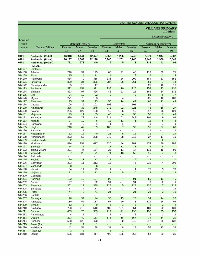
DISTRICT CENSUS HANDBOOK : PORBANDAR
VILLAGE PRIMARYC D Block -
Persons Males Females Persons Males Females Persons Males Females
1 2 41 42 43 44 45 46 47 48 49
0101 Porbandar (Total) 16,918 4,441 12,477 6,952 1,206 5,746 7,579 1,947 5,632
0101 Porbandar (Rural) 16,197 4,069 12,128 6,946 1,201 5,745 7,446 1,906 5,540
0101 Porbandar (Urban) 721 372 349 6 5 1 133 41 92
RURAL
514167 Bhetkadi - - - - - - - - -
514168 Advana 216 91 125 66 21 45 110 39 71
514169 Simar 15 4 11 4 1 3 4 1 3
514170 Rojhivada 534 79 455 335 36 299 184 33 151
514171 Ishvariya 339 34 305 287 26 261 51 7 44
514172 Bhomiyavadar 35 18 17 - - - 26 10 16
514173 Sodhana 522 151 371 238 10 228 253 123 130
514174 Shingda 423 97 326 46 23 23 186 54 132
514175 Sisli 94 12 82 3 - 3 83 6 77
514176 Miyani 271 78 193 6 4 2 225 42 183
514177 Bhavpara 125 32 93 56 14 42 60 11 49
514178 Vadala 106 5 101 103 2 101 1 1 -
514179 Ambarama 286 38 248 243 22 221 43 16 27
514180 Fatana 265 127 138 19 6 13 217 96 121
514181 Majivana 99 14 85 40 4 36 56 7 49
514182 Kunvadar 420 72 348 311 63 248 101 9 92
514183 Morana 27 19 8 12 11 1 12 6 6
514184 Paravada 9 8 1 1 1 - 8 7 1
514185 Nagka 216 47 169 106 7 99 95 27 68
514186 Bavalvav 2 1 1 - - - 1 - 1
514187 Natvarnagar 52 12 40 21 5 16 31 7 24
514188 Khambhodar 293 55 238 243 28 215 27 17 10
514189 Kindar Kheda 2 2 - - - - 2 2 -
514190 Modhvada 874 257 617 325 44 281 474 186 288
514191 Sakhpur 18 17 1 13 12 1 5 5 -
514192 Tukda Miyani 201 47 154 25 11 14 111 15 96
514193 Visavada 97 26 71 71 13 58 15 7 8
514194 Palkhada - - - - - - - - -
514195 Keshav 20 3 17 7 1 6 12 2 10
514196 Bagvadar 223 11 212 12 7 5 210 4 206
514197 Vachhoda 8 - 8 8 - 8 - - -
514198 Khistri 84 11 73 1 - 1 75 5 70
514199 Vinjhrana 21 9 12 11 5 6 8 3 5
514200 Godhana - - - - - - - - -
514201 Katvana 152 15 137 95 4 91 56 11 45
514202 Beran 97 5 92 91 - 91 3 2 1
514203 Bharvada 351 12 339 128 5 123 220 7 213
514204 Baradiya 17 4 13 2 1 1 14 2 12
514205 Ratdi 44 3 41 21 - 21 21 2 19
514206 Kantela - - - - - - - - -
514207 Shrinagar 76 32 44 36 13 23 34 14 20
514208 Rinavada 189 56 133 67 29 38 121 26 95
514209 Simani 12 3 9 6 1 5 6 2 4
514210 Bakharla 720 210 510 482 131 351 189 50 139
514211 Boricha 439 70 369 219 21 198 192 35 157
514212 Pandavadar 4 1 3 2 - 2 2 1 1
514213 Degam 223 40 183 175 18 157 34 14 20
514214 Kuchhdi 598 120 478 373 30 343 217 85 132
514215 Zaver (Part) 2 1 1 - - - - - -
514216 Kolikhada 142 54 88 31 8 23 52 13 39
514217 Ratanpar 2 2 - 1 1 - - - -
514218 Oddar 595 181 414 490 125 365 64 29 35
Name of Village
Marginal workers Cultivators Agricultural labourers
Industrial category
Location
code
number
74

PRIMARY CENSUS ABSTRACT
CENSUS ABSTRACTPorbandar
Persons Males Females Persons Males Females Persons Males Females
50 51 52 53 54 55 56 57 58 2 1
281 92 189 2,106 1,196 910 101,411 38,360 63,051 Porbandar (Total) 0101
153 57 96 1,652 905 747 90,045 34,504 55,541 Porbandar (Rural) 0101
128 35 93 454 291 163 11,366 3,856 7,510 Porbandar (Urban) 0101
RURAL
- - - - - - 810 229 581 Bhetkadi 514167
5 2 3 35 29 6 3,499 1,198 2,301 Advana 514168
- - - 7 2 5 985 428 557 Simar 514169
1 1 - 14 9 5 1,073 495 578 Rojhivada 514170
- - - 1 1 - 406 199 207 Ishvariya 514171
- - - 9 8 1 1,066 346 720 Bhomiyavadar 514172
2 1 1 29 17 12 1,785 590 1,195 Sodhana 514173
1 1 - 190 19 171 1,018 429 589 Shingda 514174
1 1 - 7 5 2 671 333 338 Sisli 514175
1 - 1 39 32 7 1,993 794 1,199 Miyani 514176
- - - 9 7 2 902 360 542 Bhavpara 514177
- - - 2 2 - 792 379 413 Vadala 514178
- - - - - - 437 208 229 Ambarama 514179
1 - 1 28 25 3 2,063 706 1,357 Fatana 514180
1 1 - 2 2 - 560 181 379 Majivana 514181
8 - 8 - - - 634 301 333 Kunvadar 514182
- - - 3 2 1 698 219 479 Morana 514183
- - - - - - 1,157 361 796 Paravada 514184
- - - 15 13 2 1,220 481 739 Nagka 514185
1 1 - - - - 162 51 111 Bavalvav 514186
- - - - - - 237 88 149 Natvarnagar 514187
5 - 5 18 10 8 1,254 512 742 Khambhodar 514188
- - - - - - 788 309 479 Kindar Kheda 514189
11 6 5 64 21 43 2,133 890 1,243 Modhvada 514190
- - - - - - 462 120 342 Sakhpur 514191
- - - 65 21 44 1,185 432 753 Tukda Miyani 514192
4 2 2 7 4 3 1,840 707 1,133 Visavada 514193
- - - - - - 568 255 313 Palkhada 514194
- - - 1 - 1 402 138 264 Keshav 514195
- - - 1 - 1 1,440 551 889 Bagvadar 514196
- - - - - - 323 108 215 Vachhoda 514197
- - - 8 6 2 412 158 254 Khistri 514198
- - - 2 1 1 737 229 508 Vinjhrana 514199
- - - - - - 611 192 419 Godhana 514200
- - - 1 - 1 593 287 306 Katvana 514201
- - - 3 3 - 400 158 242 Beran 514202
- - - 3 - 3 953 482 471 Bharvada 514203
- - - 1 1 - 206 72 134 Baradiya 514204
- - - 2 1 1 968 374 594 Ratdi 514205
- - - - - - 308 150 158 Kantela 514206
- - - 6 5 1 508 244 264 Shrinagar 514207
- - - 1 1 - 437 186 251 Rinavada 514208
- - - - - - 374 153 221 Simani 514209
10 2 8 39 27 12 2,261 933 1,328 Bakharla 514210
1 - 1 27 14 13 825 375 450 Boricha 514211
- - - - - - 330 158 172 Pandavadar 514212
5 2 3 9 6 3 2,570 939 1,631 Degam 514213
- - - 8 5 3 2,243 913 1,330 Kuchhdi 514214
- - - 2 1 1 379 125 254 Zaver (Part) 514215
13 2 11 46 31 15 1,865 648 1,217 Kolikhada 514216
- - - 1 1 - 804 250 554 Ratanpar 514217
6 6 - 35 21 14 3,198 1,154 2,044 Oddar 514218
Location
code
number
Household industry workers
Name of Village
Other workers Non-workers
of marginal workers
75

DISTRICT CENSUS HANDBOOK : PORBANDAR
VILLAGE PRIMARY
Persons Males Females Persons Males Females
1 2 3 4 5 6 7 8 9 10
Name of Village
Location
code
number
Total population (including
institutional and houseless
population)
Area of
Village in
hectares
Number of
households
C D Block -
Population in the age-group 0-6
514219 Tukda Gosa 1,573.30 377 1,821 876 945 241 113 128
514220 Keshod (Lushala) 1,302.88 102 437 221 216 52 31 21
514221 Erada 1,623.96 240 986 499 487 95 56 39
514222 Delodar 975.37 254 996 496 500 110 54 56
514223 Mitrala 982.88 264 1,077 544 533 100 50 50
514224 Rajpar 1,325.01 251 1,190 606 584 119 64 55
514225 Gosa 4,049.65 483 2,250 1,123 1,127 243 113 130
514226 Chikasa 1,216.26 176 909 467 442 115 64 51
514227 Bhad 3,337.87 648 2,663 1,389 1,274 299 175 124
514228 Garej 3,165.25 871 3,726 1,812 1,914 437 217 220
514229 Navi Bandar 82.44 235 1,193 603 590 159 77 82
514230 Ratiya 3,718.26 716 3,679 1,876 1,803 510 277 233
514231 Untada 437.18 223 1,165 616 549 164 92 72
514232 Balej 4,170.62 1,326 6,392 3,256 3,136 899 475 424
514233 Kadachh 2,741.74 1,068 5,130 2,600 2,530 504 273 231
514234 Mocha 572.19 210 1,016 530 486 123 62 61
514235 Gorsar 659.16 227 1,138 580 558 119 57 62
514236 Mander 2,364.11 962 4,683 2,417 2,266 490 260 230
514237 Chingariya 488.88 332 1,624 830 794 185 86 99
514238 Pata 1,085.95 645 3,320 1,706 1,614 457 258 199
514239 Madhavpur 3,460.57 3,699 20,241 10,465 9,776 2,514 1,320 1,194
514240 Sinhjhar Nes 14.08 58 296 154 142 41 22 19
URBAN
802522
Zavar (OG) (Part)
WARD NO.-0015 (Rural
MDDS CODE:514215)
226 990 507 483 125 71 54
514241 Khapat (CT) 694.00 3,677 16,744 8,612 8,132 1,936 982 954
76

PRIMARY CENSUS ABSTRACT
CENSUS ABSTRACTPorbandar
Persons Males Females Persons Males Females Persons Males Females
11 12 13 14 15 16 17 18 19 2
Name of Village
LiteratesScheduled Castes population Scheduled Tribes population
146 74 72 127 62 65 1,009 577 432 Tukda Gosa
- - - 6 3 3 273 159 114 Keshod (Lushala)
143 69 74 - - - 603 357 246 Erada
43 23 20 - - - 548 318 230 Delodar
76 39 37 22 9 13 602 370 232 Mitrala
45 20 25 101 50 51 704 411 293 Rajpar
103 56 47 325 162 163 1,536 876 660 Gosa
10 5 5 13 8 5 536 324 212 Chikasa
47 22 25 24 12 12 1,616 993 623 Bhad
193 98 95 - - - 2,364 1,330 1,034 Garej
- - - - - - 715 419 296 Navi Bandar
249 129 120 312 162 150 1,901 1,152 749 Ratiya
265 142 123 - - - 632 399 233 Untada
753 376 377 274 193 81 3,392 1,961 1,431 Balej
511 273 238 7 5 2 3,220 1,863 1,357 Kadachh
190 101 89 14 10 4 628 373 255 Mocha
191 109 82 - - - 698 412 286 Gorsar
548 284 264 - - - 2,729 1,638 1,091 Mander
370 191 179 - - - 982 585 397 Chingariya
86 44 42 6 3 3 1,968 1,128 840 Pata
1,675 874 801 775 408 367 11,658 6,807 4,851 Madhavpur
- - - - - - 149 82 67 Sinhjhar Nes
URBAN
6 4 2 - - - 511 289 222
Zavar (OG) (Part)
WARD NO.-0015 (Rural
MDDS CODE:514215)
1,655 834 821 207 111 96 11,432 6,377 5,055 Khapat (CT)
77

DISTRICT CENSUS HANDBOOK : PORBANDAR
VILLAGE PRIMARYC D Block -
Persons Males Females Persons Males Females Persons Males Females
1 2 20 21 22 23 24 25 26 27 28
Name of Village
Location
code
number
Illiterates Total workers Main workers
514219 Tukda Gosa 812 299 513 745 466 279 518 406 112
514220 Keshod (Lushala) 164 62 102 258 140 118 105 94 11
514221 Erada 383 142 241 606 316 290 302 290 12
514222 Delodar 448 178 270 543 318 225 393 300 93
514223 Mitrala 475 174 301 725 396 329 341 317 24
514224 Rajpar 486 195 291 646 388 258 413 356 57
514225 Gosa 714 247 467 875 662 213 769 636 133
514226 Chikasa 373 143 230 497 289 208 484 285 199
514227 Bhad 1,047 396 651 1,450 876 574 813 654 159
514228 Garej 1,362 482 880 1,774 1,148 626 1,706 1,124 582
514229 Navi Bandar 478 184 294 357 309 48 353 309 44
514230 Ratiya 1,778 724 1,054 1,557 1,080 477 1,188 919 269
514231 Untada 533 217 316 358 319 39 320 303 17
514232 Balej 3,000 1,295 1,705 2,058 1,691 367 1,604 1,527 77
514233 Kadachh 1,910 737 1,173 2,042 1,564 478 1,675 1,492 183
514234 Mocha 388 157 231 387 327 60 376 318 58
514235 Gorsar 440 168 272 506 344 162 462 332 130
514236 Mander 1,954 779 1,175 2,935 1,582 1,353 2,682 1,503 1,179
514237 Chingariya 642 245 397 1,093 560 533 1,072 557 515
514238 Pata 1,352 578 774 1,676 1,014 662 1,168 909 259
514239 Madhavpur 8,583 3,658 4,925 8,133 5,841 2,292 5,926 5,123 803
514240 Sinhjhar Nes 147 72 75 211 110 101 125 103 22
URBAN
802522
Zavar (OG) (Part)
WARD NO.-0015 (Rural
MDDS CODE:514215)
479 218 261 399 315 84 398 314 84
514241 Khapat (CT) 5,312 2,235 3,077 5,969 4,948 1,021 5,249 4,577 672
78

PRIMARY CENSUS ABSTRACT
CENSUS ABSTRACTPorbandar
Persons Males Females Persons Males Females Persons MalesFemales Persons Males Females
29 30 31 32 33 34 35 36 37 38 39 40 2
Cultivators
Name of Village
Household industry
workersAgricultural labourers
Industrial category of main workers
Other workers
137 111 26 96 66 30 14 11 3 271 218 53 Tukda Gosa
64 58 6 9 8 1 - - - 32 28 4 Keshod (Lushala)
226 219 7 65 61 4 1 1 - 10 9 1 Erada
214 184 30 142 86 56 1 1 - 36 29 7 Delodar
266 261 5 54 39 15 - - - 21 17 4 Mitrala
267 243 24 63 41 22 14 7 7 69 65 4 Rajpar
404 324 80 85 51 34 16 15 1 264 246 18 Gosa
384 215 169 29 15 14 - - - 71 55 16 Chikasa
292 277 15 331 208 123 1 - 1 189 169 20 Bhad
689 486 203 872 508 364 2 2 - 143 128 15 Garej
13 8 5 - - - 1 1 - 339 300 39 Navi Bandar
678 500 178 191 136 55 20 17 3 299 266 33 Ratiya
138 133 5 68 60 8 2 2 - 112 108 4 Untada
768 744 24 376 358 18 22 21 1 438 404 34 Balej
978 927 51 458 351 107 30 30 - 209 184 25 Kadachh
167 156 11 110 74 36 5 5 - 94 83 11 Mocha
148 137 11 110 83 27 2 - 2 202 112 90 Gorsar
959 543 416 1,600 871 729 45 26 19 78 63 15 Mander
251 173 78 671 304 367 136 72 64 14 8 6 Chingariya
527 408 119 325 211 114 7 6 1 309 284 25 Pata
1,114 911 203 1,512 1,115 397 54 53 1 3,246 3,044 202 Madhavpur
92 91 1 32 12 20 - - - 1 - 1 Sinhjhar Nes
URBAN
- - - - - - - - - 398 314 84
Zavar (OG) (Part)
WARD NO.-0015 (Rural
MDDS CODE:514215)
314 301 13 504 291 213 168 151 17 4,263 3,834 429 Khapat (CT)
79

DISTRICT CENSUS HANDBOOK : PORBANDAR
VILLAGE PRIMARYC D Block -
Persons Males Females Persons Males Females Persons Males Females
1 2 41 42 43 44 45 46 47 48 49
Name of Village
Marginal workers Cultivators Agricultural labourers
Industrial category
Location
code
number
514219 Tukda Gosa 227 60 167 6 4 2 123 25 98
514220 Keshod (Lushala) 153 46 107 4 4 - 148 41 107
514221 Erada 304 26 278 233 19 214 69 7 62
514222 Delodar 150 18 132 87 6 81 62 12 50
514223 Mitrala 384 79 305 306 53 253 68 24 44
514224 Rajpar 233 32 201 217 27 190 13 3 10
514225 Gosa 106 26 80 36 7 29 36 5 31
514226 Chikasa 13 4 9 6 3 3 5 1 4
514227 Bhad 637 222 415 63 39 24 541 156 385
514228 Garej 68 24 44 20 10 10 42 9 33
514229 Navi Bandar 4 - 4 - - - - - -
514230 Ratiya 369 161 208 152 31 121 147 82 65
514231 Untada 38 16 22 2 1 1 21 3 18
514232 Balej 454 164 290 78 36 42 245 61 184
514233 Kadachh 367 72 295 171 20 151 174 41 133
514234 Mocha 11 9 2 - - - 6 4 2
514235 Gorsar 44 12 32 3 1 2 23 6 17
514236 Mander 253 79 174 115 32 83 131 43 88
514237 Chingariya 21 3 18 6 2 4 14 1 13
514238 Pata 508 105 403 95 12 83 369 68 301
514239 Madhavpur 2,207 718 1,489 509 127 382 1,217 269 948
514240 Sinhjhar Nes 86 7 79 5 3 2 81 4 77
URBAN
802522
Zavar (OG) (Part)
WARD NO.-0015 (Rural
MDDS CODE:514215)
1 1 - - - - - - -
514241 Khapat (CT) 720 371 349 6 5 1 133 41 92
80
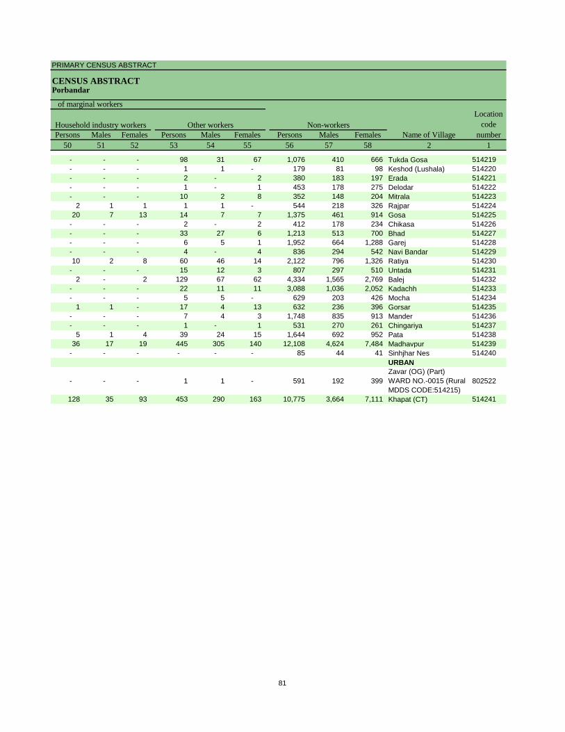
PRIMARY CENSUS ABSTRACT
CENSUS ABSTRACTPorbandar
Persons Males Females Persons Males Females Persons Males Females
50 51 52 53 54 55 56 57 58 2 1
Location
code
number
Household industry workers
Name of Village
Other workers Non-workers
of marginal workers
- - - 98 31 67 1,076 410 666 Tukda Gosa 514219
- - - 1 1 - 179 81 98 Keshod (Lushala) 514220
- - - 2 - 2 380 183 197 Erada 514221
- - - 1 - 1 453 178 275 Delodar 514222
- - - 10 2 8 352 148 204 Mitrala 514223
2 1 1 1 1 - 544 218 326 Rajpar 514224
20 7 13 14 7 7 1,375 461 914 Gosa 514225
- - - 2 - 2 412 178 234 Chikasa 514226
- - - 33 27 6 1,213 513 700 Bhad 514227
- - - 6 5 1 1,952 664 1,288 Garej 514228
- - - 4 - 4 836 294 542 Navi Bandar 514229
10 2 8 60 46 14 2,122 796 1,326 Ratiya 514230
- - - 15 12 3 807 297 510 Untada 514231
2 - 2 129 67 62 4,334 1,565 2,769 Balej 514232
- - - 22 11 11 3,088 1,036 2,052 Kadachh 514233
- - - 5 5 - 629 203 426 Mocha 514234
1 1 - 17 4 13 632 236 396 Gorsar 514235
- - - 7 4 3 1,748 835 913 Mander 514236
- - - 1 - 1 531 270 261 Chingariya 514237
5 1 4 39 24 15 1,644 692 952 Pata 514238
36 17 19 445 305 140 12,108 4,624 7,484 Madhavpur 514239
- - - - - - 85 44 41 Sinhjhar Nes 514240
URBAN
- - - 1 1 - 591 192 399
Zavar (OG) (Part)
WARD NO.-0015 (Rural
MDDS CODE:514215)
802522
128 35 93 453 290 163 10,775 3,664 7,111 Khapat (CT) 514241
81

DISTRICT CENSUS HANDBOOK : PORBANDAR
VILLAGE PRIMARY
Persons Males Females Persons Males Females
1 2 3 4 5 6 7 8 9 10
0102 Ranavav (Total) 39,285.61 14,693 68,550 34,925 33,625 8,606 4,535 4,071
0102 Ranavav (Rural) 38,781.61 13,430 62,678 31,911 30,767 7,935 4,190 3,745
0102 Ranavav (Urban) 504.00 1,263 5,872 3,014 2,858 671 345 326
RURAL
514242 Ashiyapat 1,113.94 96 428 218 210 64 22 42
514243 Hanumangadh 548.02 326 1,476 732 744 167 91 76
514244 Bileshwar 522.00 364 1,748 911 837 200 101 99
514245 Khambhala 1,300.00 270 1,438 747 691 217 131 86
514246 Dharampur 1,840.40 1,722 7,704 3,961 3,743 930 504 426
514247 Ramgadh 806.58 300 1,494 763 731 236 141 95
514248 Bordi 1,211.47 431 1,979 990 989 334 179 155
514249 Dolatgadh 419.98 327 1,703 847 856 274 140 134
514250 Khirsara 1,427.48 571 2,335 1,172 1,163 254 146 108
514251 Daiyar 627.20 266 1,285 657 628 152 80 72
514252 Valotra 943.50 393 2,001 1,050 951 253 141 112
514253 Aniali 1,358.79 373 1,771 916 855 218 117 101
514254 Bhod 2,218.68 947 4,540 2,260 2,280 654 299 355
514255 Pipaliya 1,575.98 246 1,198 618 580 149 90 59
514256 Digvijaygadh 231.82 88 463 231 232 67 37 30
514257 Virpur 1,000.16 254 1,438 797 641 203 101 102
514258 Vadwala-Rana 2,652.74 784 3,608 1,848 1,760 463 255 208
514259 Kandorna-Rana 2,702.83 1,850 8,690 4,453 4,237 976 527 449
514260 Khijdad 635.14 311 1,584 800 784 191 96 95
514261 Thoyana 1,240.72 560 2,506 1,256 1,250 269 135 134
514262 Bapodar 1,757.32 387 1,757 856 901 240 114 126
514263 Mokar 7,537.80 820 3,224 1,556 1,668 358 187 171
514264 Padardi 1,823.42 162 704 365 339 62 33 29
514265 Kerala 485.48 95 428 221 207 54 27 27
514266 Jambu 619.95 225 1,057 539 518 132 70 62
514267 Bhoddar 906.96 457 2,020 1,021 999 207 113 94
514268 Mahira 353.34 134 677 334 343 101 50 51
514269 Nerana 878.61 147 738 366 372 91 47 44
514270 Khakhravala Nes 0.00 6 30 14 16 10 6 4
514271 Bhukhbara Nes 1.00 23 116 69 47 15 10 5
514272 Ajmapat Nes 1.00 42 220 116 104 48 24 24
514273 Malek Nes 1.00 3 22 13 9 6 3 3
514274 Vijfadiya Nes 2.00 11 75 39 36 21 11 10
514275 Gandiyavad Nes 1.00 10 63 38 25 8 3 5
514276 Munjvaro Nes 0.00 - - - - - - -
514277 Fataltem Nes 1.00 17 91 53 38 14 7 7
514278 Sajanwada Nes 3.00 59 263 144 119 12 7 5
514279 Krushnay Nes 0.50 3 18 10 8 3 2 1
514280 Kathiyo Nes 1.50 15 73 38 35 15 7 8
514281 Chhapravala Nes 1.25 13 66 27 39 11 4 7
514282 Khodiyar Nes 1.00 4 30 16 14 4 2 2
514283 Fulzar Nes 2.00 15 76 35 41 15 8 7
514284 Boriavala Nes 0.50 6 34 20 14 8 3 5
514285 Karval Nes 0.25 1 8 5 3 - - -
514286 Jarera Nes 5.00 101 420 228 192 38 25 13
514287 Shermalki Nes 1.25 9 65 40 25 13 6 7
514288 Ranava Nes 2.00 21 156 80 76 34 16 18
514289 Satvira Nes 2.00 28 141 67 74 24 9 15
514290 Dhorivav Nes 0.75 2 20 7 13 2 - 2
514291 Morivirda Nes 0.80 5 27 15 12 6 1 5
514292 Umrivala Nes 0.00 - - - - - - -
514293 Dhuna Nes 0.25 3 24 13 11 7 6 1
C D Block -
Population in the age-group 0-6Number of
householdsName of Village
Location
code
number
Total population (including
institutional and houseless
population)
Area of
Village in
hectares
82

PRIMARY CENSUS ABSTRACT
CENSUS ABSTRACTRanavav
Persons Males Females Persons Males Females Persons Males Females
11 12 13 14 15 16 17 18 19 2
5,904 3,020 2,884 5,346 2,727 2,619 41,736 23,770 17,966 Ranavav (Total)
4,639 2,367 2,272 5,132 2,625 2,507 37,860 21,476 16,384 Ranavav (Rural)
1,265 653 612 214 102 112 3,876 2,294 1,582 Ranavav (Urban)
RURAL
36 17 19 119 51 68 213 129 84 Ashiyapat
- - - 154 79 75 856 488 368 Hanumangadh
141 70 71 297 158 139 991 580 411 Bileshwar
60 33 27 157 83 74 784 451 333 Khambhala
281 146 135 683 339 344 5,500 2,982 2,518 Dharampur
5 3 2 447 218 229 866 488 378 Ramgadh
63 30 33 465 249 216 1,144 648 496 Bordi
32 14 18 55 33 22 936 524 412 Dolatgadh
324 163 161 126 62 64 1,555 854 701 Khirsara
127 65 62 118 56 62 818 463 355 Daiyar
295 155 140 - - - 1,244 716 528 Valotra
240 131 109 434 221 213 1,138 661 477 Aniali
384 195 189 116 57 59 2,372 1,369 1,003 Bhod
- - - 10 8 2 817 453 364 Pipaliya
- - - 101 49 52 296 167 129 Digvijaygadh
9 8 1 68 41 27 940 585 355 Virpur
447 223 224 55 28 27 2,142 1,226 916 Vadwala-Rana
432 217 215 678 345 333 5,727 3,263 2,464 Kandorna-Rana
173 93 80 3 1 2 1,068 610 458 Khijdad
268 139 129 36 18 18 1,559 883 676 Thoyana
60 27 33 137 68 69 1,025 576 449 Bapodar
419 212 207 - - - 2,120 1,150 970 Mokar
- - - - - - 508 301 207 Padardi
38 20 18 18 10 8 256 152 104 Kerala
190 95 95 9 5 4 630 367 263 Jambu
468 240 228 - - - 1,255 740 515 Bhoddar
120 60 60 - - - 379 213 166 Mahira
27 11 16 - - - 423 244 179 Nerana
- - - - - - - - - Khakhravala Nes
- - - 116 69 47 47 32 15 Bhukhbara Nes
- - - 220 116 104 28 20 8 Ajmapat Nes
- - - - - - 1 1 - Malek Nes
- - - - - - 2 1 1 Vijfadiya Nes
- - - - - - 2 2 - Gandiyavad Nes
- - - - - - - - - Munjvaro Nes
- - - - - - - - - Fataltem Nes
- - - 1 1 - 10 7 3 Sajanwada Nes
- - - - - - - - - Krushnay Nes
- - - - - - 15 9 6 Kathiyo Nes
- - - 25 10 15 3 3 - Chhapravala Nes
- - - - - - - - - Khodiyar Nes
- - - - - - 18 11 7 Fulzar Nes
- - - 5 4 1 12 10 2 Boriavala Nes
- - - 8 5 3 7 5 2 Karval Nes
- - - 46 26 20 41 25 16 Jarera Nes
- - - - - - - - - Shermalki Nes
- - - - - - 12 4 8 Ranava Nes
- - - - - - 45 28 17 Satvira Nes
- - - 20 7 13 4 3 1 Dhorivav Nes
- - - - - - 3 - 3 Morivirda Nes
- - - - - - - - - Umrivala Nes
- - - - - - 2 1 1 Dhuna Nes
Scheduled Castes population Scheduled Tribes population
Name of Village
Literates
83

DISTRICT CENSUS HANDBOOK : PORBANDAR
VILLAGE PRIMARYC D Block -
Persons Males Females Persons Males Females Persons Males Females
1 2 20 21 22 23 24 25 26 27 28
0102 Ranavav (Total) 26,814 11,155 15,659 27,893 19,973 7,920 22,514 18,511 4,003
0102 Ranavav (Rural) 24,818 10,435 14,383 25,582 18,280 7,302 20,708 16,997 3,711
0102 Ranavav (Urban) 1,996 720 1,276 2,311 1,693 618 1,806 1,514 292
RURAL
514242 Ashiyapat 215 89 126 237 133 104 58 56 2
514243 Hanumangadh 620 244 376 493 419 74 342 311 31
514244 Bileshwar 757 331 426 759 540 219 538 399 139
514245 Khambhala 654 296 358 748 431 317 416 393 23
514246 Dharampur 2,204 979 1,225 2,648 2,169 479 2,299 1,996 303
514247 Ramgadh 628 275 353 621 459 162 449 398 51
514248 Bordi 835 342 493 808 567 241 747 558 189
514249 Dolatgadh 767 323 444 885 514 371 610 482 128
514250 Khirsara 780 318 462 1,046 685 361 788 648 140
514251 Daiyar 467 194 273 506 418 88 465 413 52
514252 Valotra 757 334 423 1,224 651 573 600 582 18
514253 Aniali 633 255 378 768 535 233 550 498 52
514254 Bhod 2,168 891 1,277 1,859 1,232 627 1,347 1,147 200
514255 Pipaliya 381 165 216 344 329 15 323 312 11
514256 Digvijaygadh 167 64 103 162 124 38 146 122 24
514257 Virpur 498 212 286 490 359 131 366 332 34
514258 Vadwala-Rana 1,466 622 844 1,578 1,080 498 1,443 1,049 394
514259 Kandorna-Rana 2,963 1,190 1,773 3,854 2,613 1,241 3,385 2,494 891
514260 Khijdad 516 190 326 532 502 30 507 486 21
514261 Thoyana 947 373 574 833 750 83 757 716 41
514262 Bapodar 732 280 452 704 516 188 700 514 186
514263 Mokar 1,104 406 698 1,225 843 382 1,036 822 214
514264 Padardi 196 64 132 348 222 126 274 202 72
514265 Kerala 172 69 103 161 132 29 99 95 4
514266 Jambu 427 172 255 283 276 7 264 257 7
514267 Bhoddar 765 281 484 603 574 29 592 569 23
514268 Mahira 298 121 177 205 198 7 204 197 7
514269 Nerana 315 122 193 190 178 12 189 178 11
514270 Khakhravala Nes 30 14 16 14 7 7 13 7 6
514271 Bhukhbara Nes 69 37 32 19 19 - 18 18 -
514272 Ajmapat Nes 192 96 96 42 40 2 39 37 2
514273 Malek Nes 21 12 9 14 8 6 10 6 4
514274 Vijfadiya Nes 73 38 35 35 19 16 22 15 7
514275 Gandiyavad Nes 61 36 25 37 22 15 37 22 15
514276 Munjvaro Nes - - - - - - - - -
514277 Fataltem Nes 91 53 38 43 28 15 39 26 13
514278 Sajanwada Nes 253 137 116 181 97 84 181 97 84
514279 Krushnay Nes 18 10 8 11 6 5 11 6 5
514280 Kathiyo Nes 58 29 29 41 21 20 41 21 20
514281 Chhapravala Nes 63 24 39 28 14 14 28 14 14
514282 Khodiyar Nes 30 16 14 15 8 7 14 7 7
514283 Fulzar Nes 58 24 34 43 24 19 30 16 14
514284 Boriavala Nes 22 10 12 19 12 7 14 8 6
514285 Karval Nes 1 - 1 4 3 1 4 3 1
514286 Jarera Nes 379 203 176 261 141 120 253 134 119
514287 Shermalki Nes 65 40 25 26 19 7 23 18 5
514288 Ranava Nes 144 76 68 80 44 36 58 31 27
514289 Satvira Nes 96 39 57 66 34 32 64 33 31
514290 Dhorivav Nes 16 4 12 17 6 11 6 6 -
514291 Morivirda Nes 24 15 9 11 7 4 11 7 4
514292 Umrivala Nes - - - - - - - - -
514293 Dhuna Nes 22 12 10 11 6 5 11 6 5
Illiterates Total workers Main workers
Name of Village
Location
code
number
84

PRIMARY CENSUS ABSTRACT
CENSUS ABSTRACTRanavav
Persons Males Females Persons Males Females Persons MalesFemales Persons Males Females
29 30 31 32 33 34 35 36 37 38 39 40 2
7,670 6,893 777 6,682 4,680 2,002 198 160 38 7,964 6,778 1,186 Ranavav (Total)
7,516 6,760 756 6,114 4,300 1,814 183 146 37 6,895 5,791 1,104 Ranavav (Rural)
154 133 21 568 380 188 15 14 1 1,069 987 82 Ranavav (Urban)
RURAL
48 48 - 2 2 - - - - 8 6 2 Ashiyapat
176 174 2 103 82 21 12 10 2 51 45 6 Hanumangadh
148 110 38 266 178 88 - - - 124 111 13 Bileshwar
204 200 4 98 91 7 - - - 114 102 12 Khambhala
105 97 8 188 150 38 33 22 11 1,973 1,727 246 Dharampur
239 238 1 117 82 35 2 1 1 91 77 14 Ramgadh
249 214 35 288 159 129 - - - 210 185 25 Bordi
215 199 16 251 157 94 - - - 144 126 18 Dolatgadh
279 259 20 338 251 87 - - - 171 138 33 Khirsara
242 240 2 147 102 45 1 1 - 75 70 5 Daiyar
286 285 1 219 209 10 10 10 - 85 78 7 Valotra
283 258 25 158 141 17 - - - 109 99 10 Aniali
455 440 15 368 268 100 - - - 524 439 85 Bhod
212 210 2 67 59 8 - - - 44 43 1 Pipaliya
46 45 1 50 30 20 - - - 50 47 3 Digvijaygadh
116 113 3 99 75 24 1 1 - 150 143 7 Virpur
532 367 165 710 501 209 45 45 - 156 136 20 Vadwala-Rana
888 688 200 1,404 855 549 61 39 22 1,032 912 120 Kandorna-Rana
358 353 5 105 92 13 1 1 - 43 40 3 Khijdad
538 521 17 116 97 19 - - - 103 98 5 Thoyana
570 439 131 110 61 49 - - - 20 14 6 Bapodar
347 331 16 437 264 173 - - - 252 227 25 Mokar
156 136 20 111 61 50 - - - 7 5 2 Padardi
64 64 - 16 15 1 1 1 - 18 15 3 Kerala
154 153 1 73 72 1 5 4 1 32 28 4 Jambu
318 312 6 172 161 11 9 9 - 93 87 6 Bhoddar
113 110 3 52 48 4 2 2 - 37 37 - Mahira
153 143 10 15 14 1 - - - 21 21 - Nerana
- - - - - - - - - 13 7 6 Khakhravala Nes
- - - - - - - - - 18 18 - Bhukhbara Nes
1 - 1 - - - - - - 38 37 1 Ajmapat Nes
- - - - - - - - - 10 6 4 Malek Nes
- - - - - - - - - 22 15 7 Vijfadiya Nes
1 - 1 - - - - - - 36 22 14 Gandiyavad Nes
- - - - - - - - - - - - Munjvaro Nes
6 6 - 24 18 6 - - - 9 2 7 Fataltem Nes
5 4 1 1 - 1 - - - 175 93 82 Sajanwada Nes
- - - - - - - - - 11 6 5 Krushnay Nes
- - - - - - - - - 41 21 20 Kathiyo Nes
- - - - - - - - - 28 14 14 Chhapravala Nes
- - - - - - - - - 14 7 7 Khodiyar Nes
- - - - - - - - - 30 16 14 Fulzar Nes
1 - 1 - - - - - - 13 8 5 Boriavala Nes
- - - - - - - - - 4 3 1 Karval Nes
5 2 3 7 3 4 - - - 241 129 112 Jarera Nes
- - - - - - - - - 23 18 5 Shermalki Nes
- - - - - - - - - 58 31 27 Ranava Nes
- - - - - - - - - 64 33 31 Satvira Nes
1 1 - - - - - - - 5 5 - Dhorivav Nes
- - - 2 2 - - - - 9 5 4 Morivirda Nes
- - - - - - - - - - - - Umrivala Nes
- - - - - - - - - 11 6 5 Dhuna Nes
Cultivators
Name of Village
Household industry
workersAgricultural labourers
Industrial category of main workers
Other workers
85

DISTRICT CENSUS HANDBOOK : PORBANDAR
VILLAGE PRIMARYC D Block -
Persons Males Females Persons Males Females Persons Males Females
1 2 41 42 43 44 45 46 47 48 49
0102 Ranavav (Total) 5,379 1,462 3,917 1,667 327 1,340 2,485 646 1,839
0102 Ranavav (Rural) 4,874 1,283 3,591 1,632 321 1,311 2,141 542 1,599
0102 Ranavav (Urban) 505 179 326 35 6 29 344 104 240
RURAL
514242 Ashiyapat 179 77 102 10 8 2 89 47 42
514243 Hanumangadh 151 108 43 80 67 13 42 21 21
514244 Bileshwar 221 141 80 1 1 - 206 130 76
514245 Khambhala 332 38 294 168 9 159 158 26 132
514246 Dharampur 349 173 176 20 12 8 36 10 26
514247 Ramgadh 172 61 111 15 15 - 149 38 111
514248 Bordi 61 9 52 37 2 35 16 2 14
514249 Dolatgadh 275 32 243 145 17 128 71 10 61
514250 Khirsara 258 37 221 71 5 66 147 21 126
514251 Daiyar 41 5 36 22 1 21 18 4 14
514252 Valotra 624 69 555 175 31 144 441 33 408
514253 Aniali 218 37 181 153 15 138 61 20 41
514254 Bhod 512 85 427 291 28 263 64 14 50
514255 Pipaliya 21 17 4 11 10 1 3 2 1
514256 Digvijaygadh 16 2 14 2 - 2 10 1 9
514257 Virpur 124 27 97 77 13 64 8 1 7
514258 Vadwala-Rana 135 31 104 30 4 26 96 23 73
514259 Kandorna-Rana 469 119 350 190 11 179 235 79 156
514260 Khijdad 25 16 9 15 9 6 6 4 2
514261 Thoyana 76 34 42 51 17 34 10 10 -
514262 Bapodar 4 2 2 - - - 3 1 2
514263 Mokar 189 21 168 19 3 16 167 17 150
514264 Padardi 74 20 54 12 8 4 57 9 48
514265 Kerala 62 37 25 17 16 1 40 16 24
514266 Jambu 19 19 - 15 15 - 1 1 -
514267 Bhoddar 11 5 6 2 2 - 3 - 3
514268 Mahira 1 1 - 1 1 - - - -
514269 Nerana 1 - 1 1 - 1 - - -
514270 Khakhravala Nes 1 - 1 - - - - - -
514271 Bhukhbara Nes 1 1 - - - - - - -
514272 Ajmapat Nes 3 3 - - - - - - -
514273 Malek Nes 4 2 2 - - - - - -
514274 Vijfadiya Nes 13 4 9 - - - - - -
514275 Gandiyavad Nes - - - - - - - - -
514276 Munjvaro Nes - - - - - - - - -
514277 Fataltem Nes 4 2 2 - - - - - -
514278 Sajanwada Nes - - - - - - - - -
514279 Krushnay Nes - - - - - - - - -
514280 Kathiyo Nes - - - - - - - - -
514281 Chhapravala Nes - - - - - - - - -
514282 Khodiyar Nes 1 1 - - - - - - -
514283 Fulzar Nes 13 8 5 - - - - - -
514284 Boriavala Nes 5 4 1 - - - - - -
514285 Karval Nes - - - - - - - - -
514286 Jarera Nes 8 7 1 - - - 3 2 1
514287 Shermalki Nes 3 1 2 - - - - - -
514288 Ranava Nes 22 13 9 - - - - - -
514289 Satvira Nes 2 1 1 - - - - - -
514290 Dhorivav Nes 11 - 11 - - - - - -
514291 Morivirda Nes - - - - - - - - -
514292 Umrivala Nes - - - - - - - - -
514293 Dhuna Nes - - - - - - - - -
Location
code
number Name of Village
Marginal workers Cultivators Agricultural labourers
Industrial category
86

PRIMARY CENSUS ABSTRACT
CENSUS ABSTRACTRanavav
Persons Males Females Persons Males Females Persons Males Females
50 51 52 53 54 55 56 57 58 2 1
46 24 22 1,181 465 716 40,657 14,952 25,705 Ranavav (Total) 0102
33 20 13 1,068 400 668 37,096 13,631 23,465 Ranavav (Rural) 0102
13 4 9 113 65 48 3,561 1,321 2,240 Ranavav (Urban) 0102
RURAL
1 - 1 79 22 57 191 85 106 Ashiyapat 514242
19 14 5 10 6 4 983 313 670 Hanumangadh 514243
- - - 14 10 4 989 371 618 Bileshwar 514244
- - - 6 3 3 690 316 374 Khambhala 514245
4 2 2 289 149 140 5,056 1,792 3,264 Dharampur 514246
- - - 8 8 - 873 304 569 Ramgadh 514247
- - - 8 5 3 1,171 423 748 Bordi 514248
- - - 59 5 54 818 333 485 Dolatgadh 514249
- - - 40 11 29 1,289 487 802 Khirsara 514250
- - - 1 - 1 779 239 540 Daiyar 514251
1 - 1 7 5 2 777 399 378 Valotra 514252
- - - 4 2 2 1,003 381 622 Aniali 514253
1 - 1 156 43 113 2,681 1,028 1,653 Bhod 514254
1 - 1 6 5 1 854 289 565 Pipaliya 514255
- - - 4 1 3 301 107 194 Digvijaygadh 514256
1 - 1 38 13 25 948 438 510 Virpur 514257
1 1 - 8 3 5 2,030 768 1,262 Vadwala-Rana 514258
1 1 - 43 28 15 4,836 1,840 2,996 Kandorna-Rana 514259
1 1 - 3 2 1 1,052 298 754 Khijdad 514260
- - - 15 7 8 1,673 506 1,167 Thoyana 514261
- - - 1 1 - 1,053 340 713 Bapodar 514262
- - - 3 1 2 1,999 713 1,286 Mokar 514263
2 1 1 3 2 1 356 143 213 Padardi 514264
- - - 5 5 - 267 89 178 Kerala 514265
- - - 3 3 - 774 263 511 Jambu 514266
- - - 6 3 3 1,417 447 970 Bhoddar 514267
- - - - - - 472 136 336 Mahira 514268
- - - - - - 548 188 360 Nerana 514269
- - - 1 - 1 16 7 9 Khakhravala Nes 514270
- - - 1 1 - 97 50 47 Bhukhbara Nes 514271
- - - 3 3 - 178 76 102 Ajmapat Nes 514272
- - - 4 2 2 8 5 3 Malek Nes 514273
- - - 13 4 9 40 20 20 Vijfadiya Nes 514274
- - - - - - 26 16 10 Gandiyavad Nes 514275
- - - - - - - - - Munjvaro Nes 514276
- - - 4 2 2 48 25 23 Fataltem Nes 514277
- - - - - - 82 47 35 Sajanwada Nes 514278
- - - - - - 7 4 3 Krushnay Nes 514279
- - - - - - 32 17 15 Kathiyo Nes 514280
- - - - - - 38 13 25 Chhapravala Nes 514281
- - - 1 1 - 15 8 7 Khodiyar Nes 514282
- - - 13 8 5 33 11 22 Fulzar Nes 514283
- - - 5 4 1 15 8 7 Boriavala Nes 514284
- - - - - - 4 2 2 Karval Nes 514285
- - - 5 5 - 159 87 72 Jarera Nes 514286
- - - 3 1 2 39 21 18 Shermalki Nes 514287
- - - 22 13 9 76 36 40 Ranava Nes 514288
- - - 2 1 1 75 33 42 Satvira Nes 514289
- - - 11 - 11 3 1 2 Dhorivav Nes 514290
- - - - - - 16 8 8 Morivirda Nes 514291
- - - - - - - - - Umrivala Nes 514292
- - - - - - 13 7 6 Dhuna Nes 514293
Non-workers
of marginal workers
Location
code
number
Household industry workers
Name of Village
Other workers
87
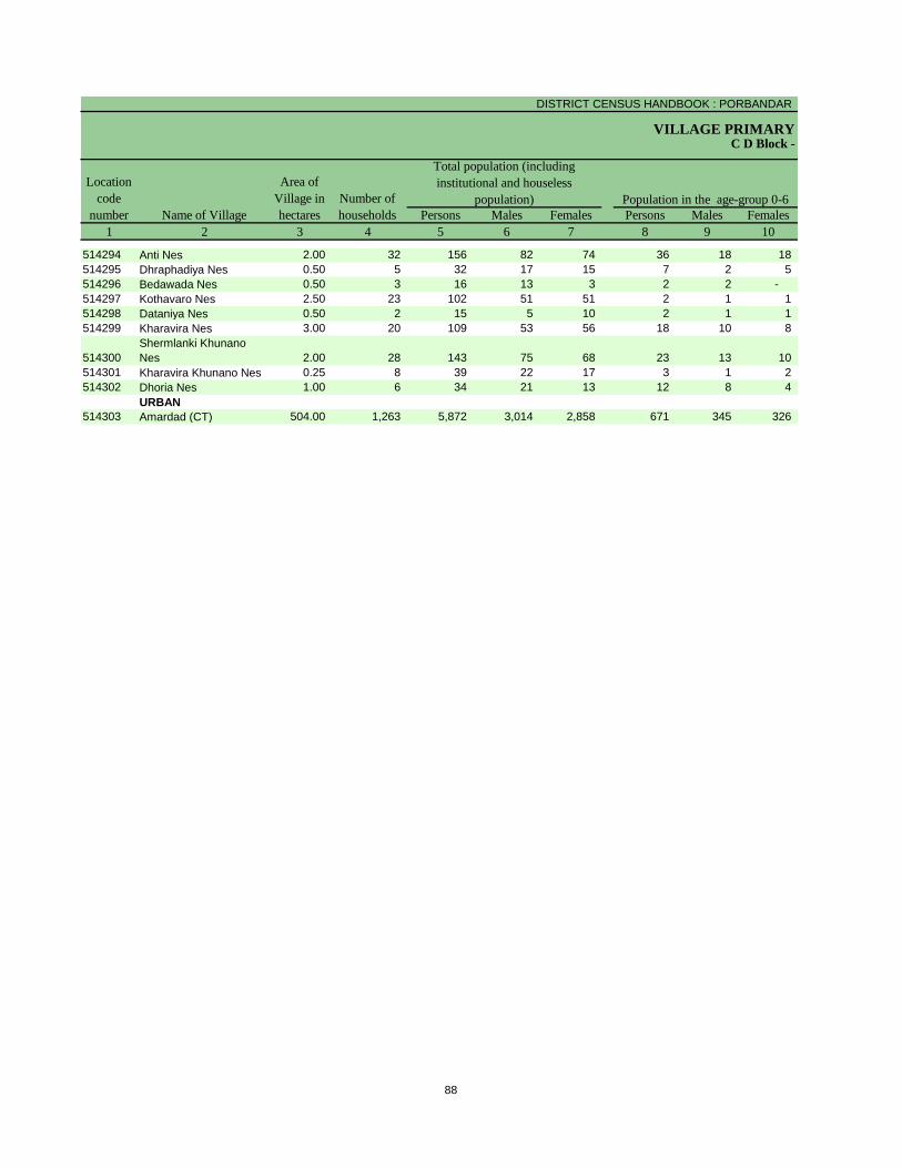
DISTRICT CENSUS HANDBOOK : PORBANDAR
VILLAGE PRIMARY
Persons Males Females Persons Males Females
1 2 3 4 5 6 7 8 9 10
C D Block -
Population in the age-group 0-6Number of
householdsName of Village
Location
code
number
Total population (including
institutional and houseless
population)
Area of
Village in
hectares
514294 Anti Nes 2.00 32 156 82 74 36 18 18
514295 Dhraphadiya Nes 0.50 5 32 17 15 7 2 5
514296 Bedawada Nes 0.50 3 16 13 3 2 2 -
514297 Kothavaro Nes 2.50 23 102 51 51 2 1 1
514298 Dataniya Nes 0.50 2 15 5 10 2 1 1
514299 Kharavira Nes 3.00 20 109 53 56 18 10 8
514300
Shermlanki Khunano
Nes 2.00 28 143 75 68 23 13 10
514301 Kharavira Khunano Nes 0.25 8 39 22 17 3 1 2
514302 Dhoria Nes 1.00 6 34 21 13 12 8 4
URBAN
514303 Amardad (CT) 504.00 1,263 5,872 3,014 2,858 671 345 326
88

PRIMARY CENSUS ABSTRACT
CENSUS ABSTRACTRanavav
Persons Males Females Persons Males Females Persons Males Females
11 12 13 14 15 16 17 18 19 2
Scheduled Castes population Scheduled Tribes population
Name of Village
Literates
- - - 156 82 74 26 17 9 Anti Nes
- - - - - - - - - Dhraphadiya Nes
- - - - - - - - - Bedawada Nes
- - - 101 51 50 - - - Kothavaro Nes
- - - - - - - - - Dataniya Nes
- - - 109 53 56 - - - Kharavira Nes
- - - - - - 20 14 6
Shermlanki Khunano
Nes
- - - 39 22 17 - - - Kharavira Khunano Nes
- - - - - - - - - Dhoria Nes
URBAN
1,265 653 612 214 102 112 3,876 2,294 1,582 Amardad (CT)
89

DISTRICT CENSUS HANDBOOK : PORBANDAR
VILLAGE PRIMARYC D Block -
Persons Males Females Persons Males Females Persons Males Females
1 2 20 21 22 23 24 25 26 27 28
Illiterates Total workers Main workers
Name of Village
Location
code
number
514294 Anti Nes 130 65 65 109 64 45 61 60 1
514295 Dhraphadiya Nes 32 17 15 15 10 5 11 8 3
514296 Bedawada Nes 16 13 3 9 7 2 9 7 2
514297 Kothavaro Nes 102 51 51 91 45 46 46 44 2
514298 Dataniya Nes 15 5 10 4 2 2 2 1 1
514299 Kharavira Nes 109 53 56 85 42 43 42 42 -
514300
Shermlanki Khunano
Nes 123 61 62 90 50 40 83 46 37
514301 Kharavira Khunano Nes 39 22 17 31 18 13 18 18 -
514302 Dhoria Nes 34 21 13 16 8 8 15 7 8
URBAN
514303 Amardad (CT) 1,996 720 1,276 2,311 1,693 618 1,806 1,514 292
90
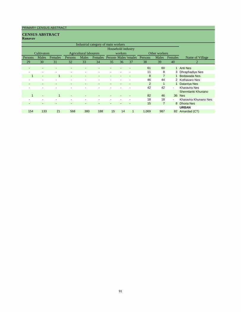
PRIMARY CENSUS ABSTRACT
CENSUS ABSTRACTRanavav
Persons Males Females Persons Males Females Persons MalesFemales Persons Males Females
29 30 31 32 33 34 35 36 37 38 39 40 2
Cultivators
Name of Village
Household industry
workersAgricultural labourers
Industrial category of main workers
Other workers
- - - - - - - - - 61 60 1 Anti Nes
- - - - - - - - - 11 8 3 Dhraphadiya Nes
1 - 1 - - - - - - 8 7 1 Bedawada Nes
- - - - - - - - - 46 44 2 Kothavaro Nes
- - - - - - - - - 2 1 1 Dataniya Nes
- - - - - - - - - 42 42 - Kharavira Nes
1 - 1 - - - - - - 82 46 36
Shermlanki Khunano
Nes
- - - - - - - - - 18 18 - Kharavira Khunano Nes
- - - - - - - - - 15 7 8 Dhoria Nes
URBAN
154 133 21 568 380 188 15 14 1 1,069 987 82 Amardad (CT)
91

DISTRICT CENSUS HANDBOOK : PORBANDAR
VILLAGE PRIMARYC D Block -
Persons Males Females Persons Males Females Persons Males Females
1 2 41 42 43 44 45 46 47 48 49
Location
code
number Name of Village
Marginal workers Cultivators Agricultural labourers
Industrial category
514294 Anti Nes 48 4 44 1 1 - - - -
514295 Dhraphadiya Nes 4 2 2 - - - - - -
514296 Bedawada Nes - - - - - - - - -
514297 Kothavaro Nes 45 1 44 - - - 1 - 1
514298 Dataniya Nes 2 1 1 - - - - - -
514299 Kharavira Nes 43 - 43 - - - - - -
514300
Shermlanki Khunano
Nes 7 4 3 - - - - - -
514301 Kharavira Khunano Nes 13 - 13 - - - - - -
514302 Dhoria Nes 1 1 - - - - - - -
URBAN
514303 Amardad (CT) 505 179 326 35 6 29 344 104 240
92
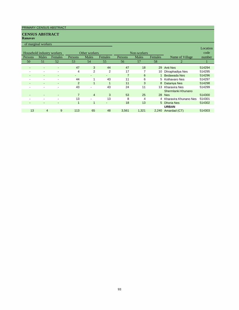
PRIMARY CENSUS ABSTRACT
CENSUS ABSTRACTRanavav
Persons Males Females Persons Males Females Persons Males Females
50 51 52 53 54 55 56 57 58 2 1
Non-workers
of marginal workers
Location
code
number
Household industry workers
Name of Village
Other workers
- - - 47 3 44 47 18 29 Anti Nes 514294
- - - 4 2 2 17 7 10 Dhraphadiya Nes 514295
- - - - - - 7 6 1 Bedawada Nes 514296
- - - 44 1 43 11 6 5 Kothavaro Nes 514297
- - - 2 1 1 11 3 8 Dataniya Nes 514298
- - - 43 - 43 24 11 13 Kharavira Nes 514299
- - - 7 4 3 53 25 28
Shermlanki Khunano
Nes 514300
- - - 13 - 13 8 4 4 Kharavira Khunano Nes 514301
- - - 1 1 - 18 13 5 Dhoria Nes 514302
URBAN
13 4 9 113 65 48 3,561 1,321 2,240 Amardad (CT) 514303
93

DISTRICT CENSUS HANDBOOK : PORBANDAR
VILLAGE PRIMARY
Persons Males Females Persons Males Females
1 2 3 4 5 6 7 8 9 10
0103 Kutiyana (Total) 53,014.48 14,900 69,640 35,661 33,979 7,899 4,115 3,784
0103 Kutiyana (Rural) 53,014.48 14,900 69,640 35,661 33,979 7,899 4,115 3,784
0103 Kutiyana (Urban) 0.00 - - - - - - -
RURAL
514304 Devda 3,005.85 773 3,821 1,980 1,841 484 254 230
514305 Ramnagar 1,421.33 301 1,564 821 743 171 97 74
514306 Khageshri 5,434.05 1,247 6,186 3,244 2,942 834 447 387
514307 Dhruvala 1,318.06 202 1,116 582 534 181 103 78
514308 Ishvariya 3,153.10 697 3,107 1,597 1,510 287 154 133
514309 Amar 1,451.67 463 2,122 1,093 1,029 240 129 111
514310 Bavlavadar 640.46 281 1,373 702 671 164 87 77
514311 Mahobatpara 827.26 451 2,110 1,072 1,038 276 139 137
514312 Hamadpara 802.56 346 1,502 772 730 179 93 86
514313 Helabeli 729.56 155 847 433 414 136 66 70
514314 Sindhpur 1,498.39 323 1,537 787 750 194 91 103
514315 Malanka 958.74 222 1,119 569 550 140 80 60
514316 Vadala 1,236.13 250 1,209 626 583 95 38 57
514317 Daduka 616.06 142 655 344 311 69 41 28
514318 Bildi 649.36 209 1,042 543 499 125 68 57
514319 Roghada 1,090.14 309 1,552 791 761 136 70 66
514320 Gokaran 564.81 332 1,390 730 660 156 82 74
514321 Khunpur 415.69 48 196 107 89 25 9 16
514322 Teri 355.05 102 454 224 230 37 20 17
514323 Choliyana 386.52 177 800 398 402 120 60 60
514324 Baloch 1,046.31 189 957 491 466 92 53 39
514325 Mal 1,008.57 311 1,381 704 677 164 77 87
514326 Chauta 738.02 653 3,113 1,597 1,516 309 152 157
514327 Thepda 237.17 231 1,105 573 532 128 73 55
514328 Mandva 1,005.42 535 2,558 1,304 1,254 250 131 119
514329 Katwana 277.17 114 562 284 278 56 30 26
514330 Kotda 1,365.57 584 2,778 1,407 1,371 325 175 150
514331 Paswali 666.04 434 1,926 979 947 178 89 89
514332 Kantol 887.56 213 886 452 434 100 48 52
514333 Moddar 891.05 336 1,480 766 714 160 74 86
514334 Segras 1,277.75 286 1,402 726 676 167 91 76
514335 Chhatrava 669.30 289 1,323 672 651 147 72 75
514336 Bhogsar 453.37 115 478 232 246 46 16 30
514337 Kavalka 761.17 191 912 454 458 93 52 41
514338 Gadhvana 410.05 78 281 141 140 14 6 8
514339 Dharsan 815.19 176 843 409 434 96 51 45
514340 Kansavad 910.88 262 1,094 537 557 123 64 59
514341 Jamra 1,460.43 212 968 494 474 82 48 34
514342 Mahiyari 3,759.71 935 4,001 1,984 2,017 446 229 217
514343 Tarkhai 951.22 236 957 486 471 96 54 42
514344 Revadra 581.56 100 470 240 230 52 30 22
514345 Bhadula 936.57 183 745 366 379 70 31 39
514346 Junej 496.55 139 671 360 311 72 43 29
514347 Farer 755.84 347 1,739 881 858 192 96 96
514348 Kadegi 1,651.83 467 2,042 1,055 987 237 116 121
514349 Mota Ghed 1,402.27
514350 Amipur 1,043.12 254 1,266 652 614 155 86 69
-------------Un-inhabited--------------
C D Block -
Population in the age-group 0-6Number of
householdsName of Village
Location
code
number
Total population (including
institutional and houseless
population)
Area of
Village in
hectares
94

PRIMARY CENSUS ABSTRACT
CENSUS ABSTRACTKutiyana
Persons Males Females Persons Males Females Persons Males Females
11 12 13 14 15 16 17 18 19 2
8,896 4,559 4,337 408 211 197 43,404 25,316 18,088 Kutiyana (Total)
8,896 4,559 4,337 408 211 197 43,404 25,316 18,088 Kutiyana (Rural)
- - - - - - - - - Kutiyana (Urban)
RURAL
340 177 163 4 3 1 2,469 1,450 1,019 Devda
97 53 44 6 3 3 959 573 386 Ramnagar
514 274 240 10 4 6 3,604 2,034 1,570 Khageshri
8 4 4 - - - 569 363 206 Dhruvala
678 335 343 - - - 2,110 1,206 904 Ishvariya
160 86 74 - - - 1,227 708 519 Amar
387 199 188 - - - 889 517 372 Bavlavadar
225 104 121 18 11 7 1,188 682 506 Mahobatpara
191 97 94 - - - 914 547 367 Hamadpara
20 11 9 - - - 372 208 164 Helabeli
57 24 33 - - - 991 582 409 Sindhpur
118 62 56 13 7 6 711 408 303 Malanka
50 29 21 - - - 832 490 342 Vadala
- - - - - - 413 236 177 Daduka
210 111 99 20 7 13 652 393 259 Bildi
471 236 235 7 3 4 1,059 610 449 Roghada
325 178 147 103 55 48 908 548 360 Gokaran
103 54 49 - - - 96 66 30 Khunpur
62 26 36 - - - 309 176 133 Teri
155 69 86 8 3 5 477 267 210 Choliyana
207 99 108 - - - 642 369 273 Baloch
78 37 41 - - - 859 515 344 Mal
463 230 233 - - - 1,993 1,134 859 Chauta
193 98 95 - - - 739 437 302 Thepda
439 227 212 15 8 7 1,664 982 682 Mandva
35 16 19 - - - 385 217 168 Katwana
155 75 80 - - - 1,777 1,014 763 Kotda
205 119 86 - - - 1,236 729 507 Paswali
606 321 285 - - - 550 334 216 Kantol
367 188 179 36 18 18 968 591 377 Moddar
298 164 134 23 11 12 867 513 354 Segras
149 79 70 52 29 23 818 495 323 Chhatrava
59 28 31 - - - 303 174 129 Bhogsar
115 59 56 - - - 571 324 247 Kavalka
83 46 37 - - - 206 128 78 Gadhvana
94 46 48 - - - 571 319 252 Dharsan
107 51 56 - - - 612 347 265 Kansavad
132 64 68 - - - 583 357 226 Jamra
301 150 151 35 21 14 2,344 1,348 996 Mahiyari
65 34 31 - - - 584 353 231 Tarkhai
70 41 29 51 26 25 283 162 121 Revadra
81 36 45 6 2 4 634 328 306 Bhadula
84 46 38 - - - 446 268 178 Junej
98 53 45 - - - 1,120 639 481 Farer
125 68 57 - - - 1,101 685 416 Kadegi
Mota Ghed
116 55 61 1 - 1 799 490 309 Amipur
-------------Un-inhabited--------------
Scheduled Castes population Scheduled Tribes population
Name of Village
Literates
95

DISTRICT CENSUS HANDBOOK : PORBANDAR
VILLAGE PRIMARYC D Block -
Persons Males Females Persons Males Females Persons Males Females
1 2 20 21 22 23 24 25 26 27 28
0103 Kutiyana (Total) 26,236 10,345 15,891 29,516 21,638 7,878 24,967 20,335 4,632
0103 Kutiyana (Rural) 26,236 10,345 15,891 29,516 21,638 7,878 24,967 20,335 4,632
0103 Kutiyana (Urban) - - - - - - - - -
RURAL
514304 Devda 1,352 530 822 1,585 1,062 523 1,574 1,057 517
514305 Ramnagar 605 248 357 492 475 17 487 470 17
514306 Khageshri 2,582 1,210 1,372 2,557 1,912 645 2,444 1,879 565
514307 Dhruvala 547 219 328 339 318 21 324 307 17
514308 Ishvariya 997 391 606 1,085 954 131 1,076 948 128
514309 Amar 895 385 510 932 708 224 929 707 222
514310 Bavlavadar 484 185 299 808 425 383 782 411 371
514311 Mahobatpara 922 390 532 764 616 148 677 604 73
514312 Hamadpara 588 225 363 592 468 124 543 458 85
514313 Helabeli 475 225 250 442 274 168 404 256 148
514314 Sindhpur 546 205 341 626 449 177 446 406 40
514315 Malanka 408 161 247 522 354 168 335 330 5
514316 Vadala 377 136 241 488 437 51 487 437 50
514317 Daduka 242 108 134 210 198 12 164 156 8
514318 Bildi 390 150 240 417 341 76 369 329 40
514319 Roghada 493 181 312 563 497 66 517 483 34
514320 Gokaran 482 182 300 455 398 57 445 393 52
514321 Khunpur 100 41 59 114 71 43 107 68 39
514322 Teri 145 48 97 254 143 111 234 131 103
514323 Choliyana 323 131 192 395 243 152 257 230 27
514324 Baloch 315 122 193 453 301 152 302 293 9
514325 Mal 522 189 333 559 458 101 471 452 19
514326 Chauta 1,120 463 657 1,305 946 359 1,058 854 204
514327 Thepda 366 136 230 552 343 209 526 331 195
514328 Mandva 894 322 572 865 833 32 858 830 28
514329 Katwana 177 67 110 385 195 190 335 191 144
514330 Kotda 1,001 393 608 880 844 36 876 840 36
514331 Paswali 690 250 440 608 591 17 603 589 14
514332 Kantol 336 118 218 303 294 9 286 279 7
514333 Moddar 512 175 337 564 472 92 538 453 85
514334 Segras 535 213 322 982 502 480 775 466 309
514335 Chhatrava 505 177 328 586 428 158 417 396 21
514336 Bhogsar 175 58 117 208 150 58 203 148 55
514337 Kavalka 341 130 211 406 279 127 391 272 119
514338 Gadhvana 75 13 62 153 96 57 57 47 10
514339 Dharsan 272 90 182 483 241 242 240 210 30
514340 Kansavad 482 190 292 533 317 216 527 314 213
514341 Jamra 385 137 248 459 312 147 254 249 5
514342 Mahiyari 1,657 636 1,021 1,602 1,266 336 1,410 1,215 195
514343 Tarkhai 373 133 240 378 287 91 291 250 41
514344 Revadra 187 78 109 264 136 128 126 97 29
514345 Bhadula 111 38 73 396 252 144 267 249 18
514346 Junej 225 92 133 394 223 171 230 213 17
514347 Farer 619 242 377 853 506 347 607 445 162
514348 Kadegi 941 370 571 1,130 642 488 675 554 121
514349 Mota Ghed
514350 Amipur 467 162 305 575 381 194 43 38 5
-------------Un-inhabited--------------
Illiterates Total workers Main workers
Name of Village
Location
code
number
96
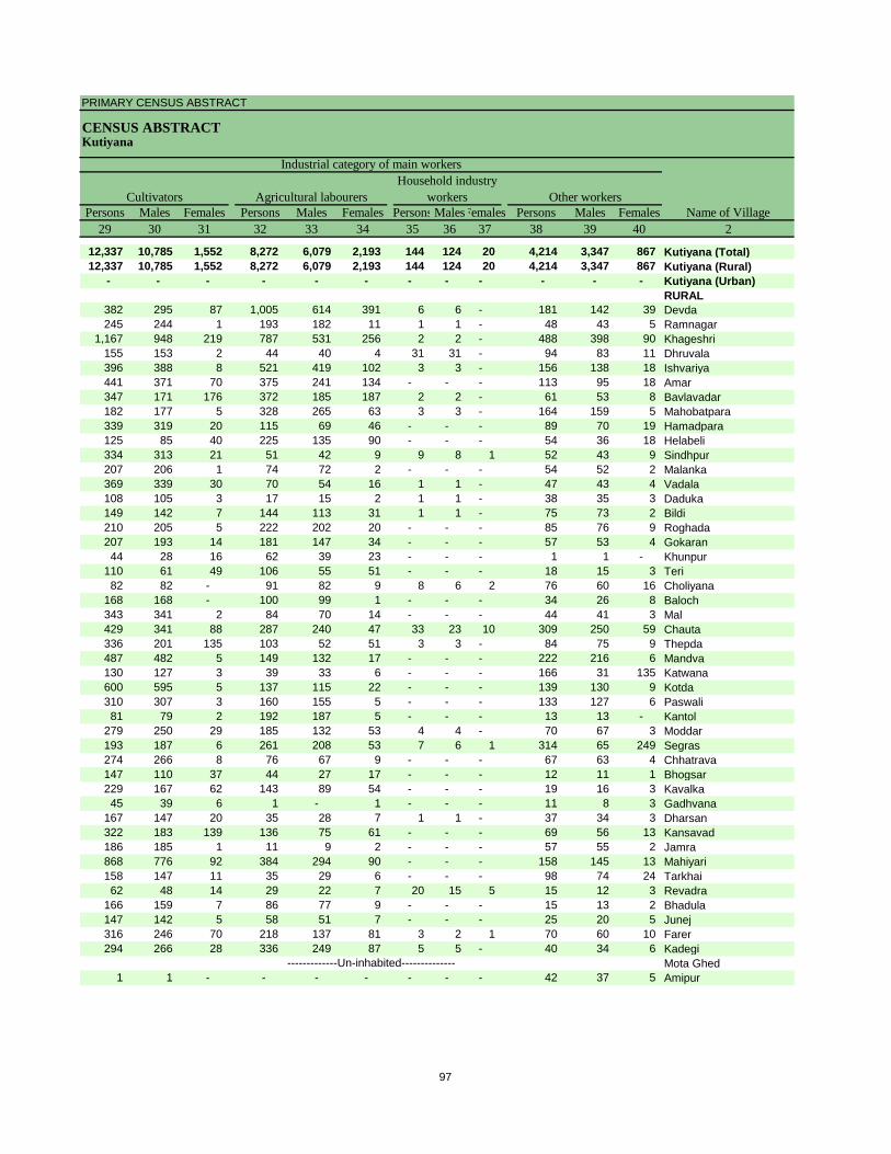
PRIMARY CENSUS ABSTRACT
CENSUS ABSTRACTKutiyana
Persons Males Females Persons Males Females Persons MalesFemales Persons Males Females
29 30 31 32 33 34 35 36 37 38 39 40 2
12,337 10,785 1,552 8,272 6,079 2,193 144 124 20 4,214 3,347 867 Kutiyana (Total)
12,337 10,785 1,552 8,272 6,079 2,193 144 124 20 4,214 3,347 867 Kutiyana (Rural)
- - - - - - - - - - - - Kutiyana (Urban)
RURAL
382 295 87 1,005 614 391 6 6 - 181 142 39 Devda
245 244 1 193 182 11 1 1 - 48 43 5 Ramnagar
1,167 948 219 787 531 256 2 2 - 488 398 90 Khageshri
155 153 2 44 40 4 31 31 - 94 83 11 Dhruvala
396 388 8 521 419 102 3 3 - 156 138 18 Ishvariya
441 371 70 375 241 134 - - - 113 95 18 Amar
347 171 176 372 185 187 2 2 - 61 53 8 Bavlavadar
182 177 5 328 265 63 3 3 - 164 159 5 Mahobatpara
339 319 20 115 69 46 - - - 89 70 19 Hamadpara
125 85 40 225 135 90 - - - 54 36 18 Helabeli
334 313 21 51 42 9 9 8 1 52 43 9 Sindhpur
207 206 1 74 72 2 - - - 54 52 2 Malanka
369 339 30 70 54 16 1 1 - 47 43 4 Vadala
108 105 3 17 15 2 1 1 - 38 35 3 Daduka
149 142 7 144 113 31 1 1 - 75 73 2 Bildi
210 205 5 222 202 20 - - - 85 76 9 Roghada
207 193 14 181 147 34 - - - 57 53 4 Gokaran
44 28 16 62 39 23 - - - 1 1 - Khunpur
110 61 49 106 55 51 - - - 18 15 3 Teri
82 82 - 91 82 9 8 6 2 76 60 16 Choliyana
168 168 - 100 99 1 - - - 34 26 8 Baloch
343 341 2 84 70 14 - - - 44 41 3 Mal
429 341 88 287 240 47 33 23 10 309 250 59 Chauta
336 201 135 103 52 51 3 3 - 84 75 9 Thepda
487 482 5 149 132 17 - - - 222 216 6 Mandva
130 127 3 39 33 6 - - - 166 31 135 Katwana
600 595 5 137 115 22 - - - 139 130 9 Kotda
310 307 3 160 155 5 - - - 133 127 6 Paswali
81 79 2 192 187 5 - - - 13 13 - Kantol
279 250 29 185 132 53 4 4 - 70 67 3 Moddar
193 187 6 261 208 53 7 6 1 314 65 249 Segras
274 266 8 76 67 9 - - - 67 63 4 Chhatrava
147 110 37 44 27 17 - - - 12 11 1 Bhogsar
229 167 62 143 89 54 - - - 19 16 3 Kavalka
45 39 6 1 - 1 - - - 11 8 3 Gadhvana
167 147 20 35 28 7 1 1 - 37 34 3 Dharsan
322 183 139 136 75 61 - - - 69 56 13 Kansavad
186 185 1 11 9 2 - - - 57 55 2 Jamra
868 776 92 384 294 90 - - - 158 145 13 Mahiyari
158 147 11 35 29 6 - - - 98 74 24 Tarkhai
62 48 14 29 22 7 20 15 5 15 12 3 Revadra
166 159 7 86 77 9 - - - 15 13 2 Bhadula
147 142 5 58 51 7 - - - 25 20 5 Junej
316 246 70 218 137 81 3 2 1 70 60 10 Farer
294 266 28 336 249 87 5 5 - 40 34 6 Kadegi
Mota Ghed
1 1 - - - - - - - 42 37 5 Amipur
-------------Un-inhabited--------------
Cultivators
Name of Village
Household industry
workersAgricultural labourers
Industrial category of main workers
Other workers
97

DISTRICT CENSUS HANDBOOK : PORBANDAR
VILLAGE PRIMARYC D Block -
Persons Males Females Persons Males Females Persons Males Females
1 2 41 42 43 44 45 46 47 48 49
0103 Kutiyana (Total) 4,549 1,303 3,246 1,995 563 1,432 1,858 525 1,333
0103 Kutiyana (Rural) 4,549 1,303 3,246 1,995 563 1,432 1,858 525 1,333
0103 Kutiyana (Urban) - - - - - - - - -
RURAL
514304 Devda 11 5 6 8 3 5 2 2 -
514305 Ramnagar 5 5 - - - - 4 4 -
514306 Khageshri 113 33 80 32 14 18 60 10 50
514307 Dhruvala 15 11 4 2 2 - 2 2 -
514308 Ishvariya 9 6 3 - - - 6 3 3
514309 Amar 3 1 2 2 1 1 1 - 1
514310 Bavlavadar 26 14 12 12 7 5 13 6 7
514311 Mahobatpara 87 12 75 13 1 12 42 7 35
514312 Hamadpara 49 10 39 13 1 12 35 8 27
514313 Helabeli 38 18 20 7 2 5 23 11 12
514314 Sindhpur 180 43 137 157 38 119 4 - 4
514315 Malanka 187 24 163 79 17 62 40 2 38
514316 Vadala 1 - 1 1 - 1 - - -
514317 Daduka 46 42 4 7 7 - 21 19 2
514318 Bildi 48 12 36 5 2 3 37 6 31
514319 Roghada 46 14 32 4 3 1 39 9 30
514320 Gokaran 10 5 5 2 2 - 4 2 2
514321 Khunpur 7 3 4 2 1 1 3 - 3
514322 Teri 20 12 8 7 5 2 4 2 2
514323 Choliyana 138 13 125 31 7 24 81 2 79
514324 Baloch 151 8 143 99 6 93 46 1 45
514325 Mal 88 6 82 69 4 65 13 1 12
514326 Chauta 247 92 155 52 20 32 137 43 94
514327 Thepda 26 12 14 19 8 11 6 4 2
514328 Mandva 7 3 4 2 1 1 2 - 2
514329 Katwana 50 4 46 1 - 1 - - -
514330 Kotda 4 4 - 1 1 - 2 2 -
514331 Paswali 5 2 3 1 - 1 1 1 -
514332 Kantol 17 15 2 3 3 - 8 6 2
514333 Moddar 26 19 7 10 7 3 10 7 3
514334 Segras 207 36 171 1 1 - 25 17 8
514335 Chhatrava 169 32 137 27 2 25 137 26 111
514336 Bhogsar 5 2 3 4 2 2 - - -
514337 Kavalka 15 7 8 4 3 1 11 4 7
514338 Gadhvana 96 49 47 24 6 18 71 42 29
514339 Dharsan 243 31 212 192 24 168 41 6 35
514340 Kansavad 6 3 3 1 1 - - - -
514341 Jamra 205 63 142 155 31 124 41 25 16
514342 Mahiyari 192 51 141 102 23 79 77 17 60
514343 Tarkhai 87 37 50 37 18 19 30 13 17
514344 Revadra 138 39 99 54 13 41 48 12 36
514345 Bhadula 129 3 126 87 2 85 41 - 41
514346 Junej 164 10 154 116 8 108 47 2 45
514347 Farer 246 61 185 104 31 73 126 23 103
514348 Kadegi 455 88 367 229 32 197 211 47 164
514349 Mota Ghed
514350 Amipur 532 343 189 217 203 14 306 131 175
-------------Un-inhabited--------------
Location
code
number Name of Village
Marginal workers Cultivators Agricultural labourers
Industrial category
98

PRIMARY CENSUS ABSTRACT
CENSUS ABSTRACTKutiyana
Persons Males Females Persons Males Females Persons Males Females
50 51 52 53 54 55 56 57 58 2 1
65 12 53 631 203 428 40,124 14,023 26,101 Kutiyana (Total) 0103
65 12 53 631 203 428 40,124 14,023 26,101 Kutiyana (Rural) 0103
- - - - - - - - - Kutiyana (Urban) 0103
RURAL
1 - 1 - - - 2,236 918 1,318 Devda 514304
- - - 1 1 - 1,072 346 726 Ramnagar 514305
5 - 5 16 9 7 3,629 1,332 2,297 Khageshri 514306
- - - 11 7 4 777 264 513 Dhruvala 514307
- - - 3 3 - 2,022 643 1,379 Ishvariya 514308
- - - - - - 1,190 385 805 Amar 514309
- - - 1 1 - 565 277 288 Bavlavadar 514310
- - - 32 4 28 1,346 456 890 Mahobatpara 514311
- - - 1 1 - 910 304 606 Hamadpara 514312
- - - 8 5 3 405 159 246 Helabeli 514313
18 4 14 1 1 - 911 338 573 Sindhpur 514314
- - - 68 5 63 597 215 382 Malanka 514315
- - - - - - 721 189 532 Vadala 514316
- - - 18 16 2 445 146 299 Daduka 514317
1 - 1 5 4 1 625 202 423 Bildi 514318
- - - 3 2 1 989 294 695 Roghada 514319
- - - 4 1 3 935 332 603 Gokaran 514320
- - - 2 2 - 82 36 46 Khunpur 514321
- - - 9 5 4 200 81 119 Teri 514322
10 - 10 16 4 12 405 155 250 Choliyana 514323
- - - 6 1 5 504 190 314 Baloch 514324
- - - 6 1 5 822 246 576 Mal 514325
10 2 8 48 27 21 1,808 651 1,157 Chauta 514326
- - - 1 - 1 553 230 323 Thepda 514327
- - - 3 2 1 1,693 471 1,222 Mandva 514328
- - - 49 4 45 177 89 88 Katwana 514329
- - - 1 1 - 1,898 563 1,335 Kotda 514330
- - - 3 1 2 1,318 388 930 Paswali 514331
- - - 6 6 - 583 158 425 Kantol 514332
- - - 6 5 1 916 294 622 Moddar 514333
- - - 181 18 163 420 224 196 Segras 514334
- - - 5 4 1 737 244 493 Chhatrava 514335
- - - 1 - 1 270 82 188 Bhogsar 514336
- - - - - - 506 175 331 Kavalka 514337
- - - 1 1 - 128 45 83 Gadhvana 514338
- - - 10 1 9 360 168 192 Dharsan 514339
- - - 5 2 3 561 220 341 Kansavad 514340
- - - 9 7 2 509 182 327 Jamra 514341
2 1 1 11 10 1 2,399 718 1,681 Mahiyari 514342
2 - 2 18 6 12 579 199 380 Tarkhai 514343
12 2 10 24 12 12 206 104 102 Revadra 514344
- - - 1 1 - 349 114 235 Bhadula 514345
- - - 1 - 1 277 137 140 Junej 514346
3 2 1 13 5 8 886 375 511 Farer 514347
1 1 - 14 8 6 912 413 499 Kadegi 514348
Mota Ghed 514349
- - - 9 9 - 691 271 420 Amipur 514350
-------------Un-inhabited--------------
Non-workers
of marginal workers
Location
code
number
Household industry workers
Name of Village
Other workers
99


Urban PCA-Town wise
Primary Census Abstract

DISTRICT CENSUS HANDBOOK : PORBANDAR
URBAN PRIMARY
Persons Males Females Persons Males Females
1 2 3 4 5 6 7 8 9 10
802522 Porbandar (M + OG) 32.72 32,568 152,760 78,604 74,156 14,934 7,922 7,012
0001 Ward No. 1 3,721 17,553 9,160 8,393 1,925 1,019 906
0002 Ward No. 2 2,060 10,022 5,186 4,836 1,116 599 517
0003 Ward No. 3 2,188 10,095 5,116 4,979 881 461 420
0004 Ward No. 4 2,453 11,049 5,757 5,292 1,217 641 576
0005 Ward No. 5 2,551 11,601 5,945 5,656 1,104 598 506
0006 Ward No. 6 2,215 9,933 5,144 4,789 800 421 379
0007 Ward No. 7 2,561 11,071 5,715 5,356 811 420 391
0008 Ward No. 8 1,657 7,665 3,888 3,777 668 345 323
0009 Ward No. 9 1,823 8,803 4,443 4,360 917 480 437
0010 Ward No. 10 1,794 9,824 4,977 4,847 1,242 650 592
0011 Ward No. 11 1,895 8,659 4,361 4,298 762 398 364
0012 Ward No. 12 2,100 10,177 5,240 4,937 950 520 430
0013 Ward No. 13 2,185 9,768 5,008 4,760 774 415 359
0014 Ward No. 14 3,139 15,550 8,157 7,393 1,642 884 758
0015 Ward No. 15 226 990 507 483 125 71 54
802523 Chhaya (M) 17.76 10,534 47,699 24,718 22,981 5,094 2,741 2,353
0001 Ward No. 1 537 2,141 1,137 1,004 257 125 132
0002 Ward No. 2 1,146 5,305 2,716 2,589 486 246 240
0003 Ward No. 3 1,098 5,015 2,571 2,444 478 229 249
0004 Ward No. 4 950 4,179 2,161 2,018 437 235 202
0005 Ward No. 5 621 2,742 1,401 1,341 255 147 108
0006 Ward No. 6 1,440 6,463 3,367 3,096 655 353 302
0007 Ward No. 7 979 4,555 2,368 2,187 509 276 233
0008 Ward No. 8 1,468 6,810 3,601 3,209 797 453 344
0009 Ward No. 9 2,295 10,489 5,396 5,093 1,220 677 543
514241 Khapat (CT) 6.94 3,677 16,744 8,612 8,132 1,936 982 954
0001 Ward No. 1 3,677 16,744 8,612 8,132 1,936 982 954
802524 Ranavav (M) 79.66 9,635 46,018 23,550 22,468 5,682 2,970 2,712
0001 Ward No. 1 880 3,903 2,006 1,897 404 197 207
0002 Ward No. 2 937 4,994 2,526 2,468 755 367 388
0003 Ward No. 3 848 4,152 2,163 1,989 552 310 242
0004 Ward No. 4 1,153 5,376 2,861 2,515 662 351 311
0005 Ward No. 5 956 4,312 2,175 2,137 450 246 204
0006 Ward No. 6 1,197 5,664 2,869 2,795 753 406 347
0007 Ward No. 7 935 4,660 2,360 2,300 543 287 256
0008 Ward No. 8 979 4,657 2,352 2,305 578 306 272
0009 Ward No. 9 1,305 6,092 3,111 2,981 688 360 328
0010 Ward No. 10 445 2,208 1,127 1,081 297 140 157
514303 Amardad (CT) 5.04 1,263 5,872 3,014 2,858 671 345 326
0001 Ward No. 1 1,263 5,872 3,014 2,858 671 345 326
802525 Kutiyana (M) 36.21 3,475 16,581 8,451 8,130 1,823 938 885
0001 Ward No. 1 811 3,853 1,976 1,877 466 239 227
0002 Ward No. 2 563 2,582 1,306 1,276 268 144 124
0003 Ward No. 3 424 1,944 968 976 184 103 81
0004 Ward No. 4 426 2,246 1,152 1,094 206 111 95
0005 Ward No. 5 412 1,961 1,003 958 207 96 111
0006 Ward No. 6 389 2,041 1,033 1,008 289 144 145
0007 Ward No. 7 450 1,954 1,013 941 203 101 102
Name of Town/ Ward
Location
code
number
Total population (including
institutional and houseless
population)
Area in
Square
Kilometr
e
Number of
households
Population in the age-group 0-6
102

PRIMARY CENSUS ABSTRACT
CENSUS ABSTRACT
Persons Males Females Persons Males Females Persons Males Females
11 12 13 14 15 16 17 18 19 2
8,130 4,097 4,033 1,005 519 486 117,963 63,988 53,975 Porbandar (M + OG)
816 424 392 24 9 15 12,605 7,112 5,493 Ward No. 1
1,928 999 929 37 20 17 7,194 3,963 3,231 Ward No. 2
38 19 19 4 2 2 8,411 4,444 3,967 Ward No. 3
335 175 160 33 17 16 7,315 4,140 3,175 Ward No. 4
3,074 1,511 1,563 70 34 36 9,110 4,964 4,146 Ward No. 5
47 24 23 191 98 93 8,379 4,539 3,840 Ward No. 6
91 55 36 107 61 46 9,791 5,143 4,648 Ward No. 7
38 18 20 4 2 2 6,377 3,369 3,008 Ward No. 8
1,423 692 731 - - - 6,301 3,442 2,859 Ward No. 9
- - - - - - 6,822 3,754 3,068 Ward No. 10
- - - - - - 6,165 3,321 2,844 Ward No. 11
- - - - - - 8,056 4,319 3,737 Ward No. 12
198 96 102 36 16 20 8,370 4,385 3,985 Ward No. 13
136 80 56 499 260 239 12,556 6,804 5,752 Ward No. 14
6 4 2 - - - 511 289 222 Ward No. 15
5,174 2,663 2,511 866 429 437 35,782 19,889 15,893 Chhaya (M)
114 54 60 4 2 2 1,493 888 605 Ward No. 1
4 2 2 46 24 22 4,374 2,360 2,014 Ward No. 2
8 5 3 - - - 4,055 2,231 1,824 Ward No. 3
- - - - - - 3,302 1,812 1,490 Ward No. 4
39 21 18 - - - 2,248 1,208 1,040 Ward No. 5
3,760 1,928 1,832 7 2 5 4,775 2,711 2,064 Ward No. 6
18 9 9 407 201 206 3,261 1,855 1,406 Ward No. 7
40 17 23 42 22 20 4,810 2,757 2,053 Ward No. 8
1,191 627 564 360 178 182 7,464 4,067 3,397 Ward No. 9
1,655 834 821 207 111 96 11,432 6,377 5,055 Khapat (CT)
1,655 834 821 207 111 96 11,432 6,377 5,055 Ward No. 1
4,792 2,509 2,283 772 405 367 29,946 16,894 13,052 Ranavav (M)
655 336 319 9 6 3 2,626 1,512 1,114 Ward No. 1
549 291 258 125 68 57 2,522 1,487 1,035 Ward No. 2
1,163 619 544 60 33 27 2,409 1,426 983 Ward No. 3
894 485 409 219 117 102 3,585 2,129 1,456 Ward No. 4
33 16 17 40 16 24 3,213 1,737 1,476 Ward No. 5
279 131 148 77 32 45 3,727 2,057 1,670 Ward No. 6
1,148 590 558 - - - 3,263 1,805 1,458 Ward No. 7
- - - 207 112 95 3,124 1,679 1,445 Ward No. 8
27 16 11 35 21 14 4,066 2,242 1,824 Ward No. 9
44 25 19 - - - 1,411 820 591 Ward No. 10
1,265 653 612 214 102 112 3,876 2,294 1,582 Amardad (CT)
1,265 653 612 214 102 112 3,876 2,294 1,582 Ward No. 1
1,746 896 850 30 18 12 11,486 6,441 5,045 Kutiyana (M)
64 35 29 11 6 5 2,381 1,379 1,002 Ward No. 1
1,344 684 660 4 2 2 1,778 1,000 778 Ward No. 2
15 7 8 - - - 1,553 813 740 Ward No. 3
- - - 4 3 1 1,797 971 826 Ward No. 4
54 31 23 9 6 3 1,474 844 630 Ward No. 5
22 9 13 - - - 1,180 664 516 Ward No. 6
247 130 117 2 1 1 1,323 770 553 Ward No. 7
Name of Town/ Ward
LiteratesScheduled Castes population Scheduled Tribes population
103

DISTRICT CENSUS HANDBOOK : PORBANDAR
URBAN PRIMARY
Persons Males Females Persons Males Females Persons Males Females
1 2 20 21 22 23 24 25 26 27 28
802522 Porbandar (M + OG) 34,797 14,616 20,181 52,027 44,360 7,667 46,170 40,325 5,845
0001 Ward No. 1 4,948 2,048 2,900 6,213 5,329 884 5,125 4,602 523
0002 Ward No. 2 2,828 1,223 1,605 3,260 2,823 437 2,824 2,536 288
0003 Ward No. 3 1,684 672 1,012 3,293 2,966 327 2,860 2,612 248
0004 Ward No. 4 3,734 1,617 2,117 4,029 3,251 778 3,470 2,915 555
0005 Ward No. 5 2,491 981 1,510 4,059 3,251 808 3,712 3,038 674
0006 Ward No. 6 1,554 605 949 3,182 2,797 385 2,969 2,646 323
0007 Ward No. 7 1,280 572 708 3,744 3,279 465 3,410 3,038 372
0008 Ward No. 8 1,288 519 769 2,420 2,124 296 2,203 1,959 244
0009 Ward No. 9 2,502 1,001 1,501 3,004 2,620 384 2,778 2,466 312
0010 Ward No. 10 3,002 1,223 1,779 3,571 2,730 841 3,376 2,609 767
0011 Ward No. 11 2,494 1,040 1,454 2,964 2,529 435 2,535 2,208 327
0012 Ward No. 12 2,121 921 1,200 3,474 3,053 421 3,109 2,779 330
0013 Ward No. 13 1,398 623 775 3,308 2,814 494 2,787 2,484 303
0014 Ward No. 14 2,994 1,353 1,641 5,107 4,479 628 4,614 4,119 495
0015 Ward No. 15 479 218 261 399 315 84 398 314 84
802523 Chhaya (M) 11,917 4,829 7,088 15,738 13,807 1,931 14,164 12,716 1,448
0001 Ward No. 1 648 249 399 824 660 164 805 650 155
0002 Ward No. 2 931 356 575 1,664 1,537 127 1,628 1,515 113
0003 Ward No. 3 960 340 620 1,630 1,469 161 1,543 1,417 126
0004 Ward No. 4 877 349 528 1,339 1,226 113 1,216 1,151 65
0005 Ward No. 5 494 193 301 824 774 50 741 703 38
0006 Ward No. 6 1,688 656 1,032 2,379 1,954 425 1,886 1,613 273
0007 Ward No. 7 1,294 513 781 1,361 1,287 74 1,301 1,243 58
0008 Ward No. 8 2,000 844 1,156 2,187 1,977 210 1,923 1,769 154
0009 Ward No. 9 3,025 1,329 1,696 3,530 2,923 607 3,121 2,655 466
514241 Khapat (CT) 5,312 2,235 3,077 5,969 4,948 1,021 5,249 4,577 672
0001 Ward No. 1 5,312 2,235 3,077 5,969 4,948 1,021 5,249 4,577 672
802524 Ranavav (M) 16,072 6,656 9,416 17,175 13,351 3,824 16,103 12,794 3,309
0001 Ward No. 1 1,277 494 783 1,798 1,213 585 1,749 1,186 563
0002 Ward No. 2 2,472 1,039 1,433 2,069 1,427 642 1,997 1,396 601
0003 Ward No. 3 1,743 737 1,006 1,816 1,249 567 1,655 1,163 492
0004 Ward No. 4 1,791 732 1,059 2,180 1,694 486 1,977 1,587 390
0005 Ward No. 5 1,099 438 661 1,354 1,223 131 1,338 1,215 123
0006 Ward No. 6 1,937 812 1,125 1,833 1,593 240 1,767 1,559 208
0007 Ward No. 7 1,397 555 842 1,598 1,349 249 1,515 1,292 223
0008 Ward No. 8 1,533 673 860 1,519 1,226 293 1,259 1,123 136
0009 Ward No. 9 2,026 869 1,157 2,112 1,740 372 1,994 1,659 335
0010 Ward No. 10 797 307 490 896 637 259 852 614 238
514303 Amardad (CT) 1,996 720 1,276 2,311 1,693 618 1,806 1,514 292
0001 Ward No. 1 1,996 720 1,276 2,311 1,693 618 1,806 1,514 292
802525 Kutiyana (M) 5,095 2,010 3,085 5,439 4,857 582 5,055 4,579 476
0001 Ward No. 1 1,472 597 875 1,355 1,133 222 1,173 1,023 150
0002 Ward No. 2 804 306 498 861 762 99 814 727 87
0003 Ward No. 3 391 155 236 627 576 51 569 529 40
0004 Ward No. 4 449 181 268 739 699 40 728 689 39
0005 Ward No. 5 487 159 328 653 602 51 624 578 46
0006 Ward No. 6 861 369 492 596 538 58 580 523 57
0007 Ward No. 7 631 243 388 608 547 61 567 510 57
Name of Town/ Ward
Location
code
number
Illiterates Total workers Main workers
104

PRIMARY CENSUS ABSTRACT
CENSUS ABSTRACT
Persons Males Females Persons Males Females Persons Males Females Persons Males Females
29 30 31 32 33 34 35 36 37 38 39 40 2
547 507 40 330 275 55 514 363 151 44,779 39,180 5,599 Porbandar (M + OG)
439 423 16 194 160 34 138 101 37 4,354 3,918 436 Ward No. 1
5 5 - 13 12 1 66 51 15 2,740 2,468 272 Ward No. 2
6 6 - 5 4 1 10 9 1 2,839 2,593 246 Ward No. 3
8 7 1 23 18 5 23 14 9 3,416 2,876 540 Ward No. 4
17 11 6 10 9 1 26 18 8 3,659 3,000 659 Ward No. 5
19 15 4 19 15 4 33 29 4 2,898 2,587 311 Ward No. 6
10 8 2 11 11 - 19 18 1 3,370 3,001 369 Ward No. 7
8 7 1 2 2 - 51 39 12 2,142 1,911 231 Ward No. 8
2 2 - 7 7 - 18 5 13 2,751 2,452 299 Ward No. 9
6 4 2 12 10 2 17 3 14 3,341 2,592 749 Ward No. 10
1 - 1 4 4 - 7 1 6 2,523 2,203 320 Ward No. 11
7 5 2 10 7 3 22 15 7 3,070 2,752 318 Ward No. 12
6 6 - 11 8 3 15 10 5 2,755 2,460 295 Ward No. 13
13 8 5 9 8 1 69 50 19 4,523 4,053 470 Ward No. 14
- - - - - - - - - 398 314 84 Ward No. 15
233 212 21 184 142 42 50 36 14 13,697 12,326 1,371 Chhaya (M)
2 1 1 3 2 1 1 1 - 799 646 153 Ward No. 1
20 17 3 4 2 2 2 2 - 1,602 1,494 108 Ward No. 2
18 18 - 7 7 - 4 3 1 1,514 1,389 125 Ward No. 3
34 34 - 7 7 - 4 3 1 1,171 1,107 64 Ward No. 4
30 30 - 4 4 - 3 2 1 704 667 37 Ward No. 5
16 11 5 49 32 17 11 7 4 1,810 1,563 247 Ward No. 6
7 6 1 4 3 1 - - - 1,290 1,234 56 Ward No. 7
44 33 11 77 59 18 12 7 5 1,790 1,670 120 Ward No. 8
62 62 - 29 26 3 13 11 2 3,017 2,556 461 Ward No. 9
314 301 13 504 291 213 168 151 17 4,263 3,834 429 Khapat (CT)
314 301 13 504 291 213 168 151 17 4,263 3,834 429 Ward No. 1
1,955 1,410 545 2,737 1,566 1,171 62 37 25 11,349 9,781 1,568 Ranavav (M)
641 361 280 313 127 186 2 1 1 793 697 96 Ward No. 1
310 172 138 500 274 226 - - - 1,187 950 237 Ward No. 2
32 29 3 458 193 265 4 1 3 1,161 940 221 Ward No. 3
66 50 16 544 302 242 8 4 4 1,359 1,231 128 Ward No. 4
52 51 1 227 200 27 11 10 1 1,048 954 94 Ward No. 5
72 62 10 146 124 22 4 3 1 1,545 1,370 175 Ward No. 6
15 14 1 66 39 27 14 4 10 1,420 1,235 185 Ward No. 7
158 121 37 127 94 33 1 1 - 973 907 66 Ward No. 8
531 477 54 217 145 72 9 7 2 1,237 1,030 207 Ward No. 9
78 73 5 139 68 71 9 6 3 626 467 159 Ward No. 10
154 133 21 568 380 188 15 14 1 1,069 987 82 Amardad (CT)
154 133 21 568 380 188 15 14 1 1,069 987 82 Ward No. 1
430 422 8 1,239 1,062 177 142 93 49 3,244 3,002 242 Kutiyana (M)
186 184 2 408 348 60 111 64 47 468 427 41 Ward No. 1
21 21 - 256 218 38 15 15 - 522 473 49 Ward No. 2
39 37 2 121 113 8 8 8 - 401 371 30 Ward No. 3
105 105 - 75 65 10 - - - 548 519 29 Ward No. 4
41 40 1 48 43 5 2 2 - 533 493 40 Ward No. 5
15 13 2 256 220 36 3 3 - 306 287 19 Ward No. 6
23 22 1 75 55 20 3 1 2 466 432 34 Ward No. 7
Name of Town/ Ward
Household industry
workersAgricultural labourers
Industrial category of main workers
Other workersCultivators
105
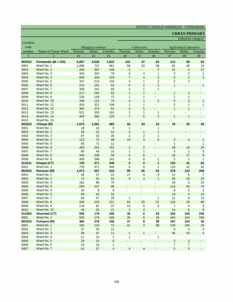
DISTRICT CENSUS HANDBOOK : PORBANDAR
URBAN PRIMARY
Persons Males Females Persons Males Females Persons Males Females
1 2 41 42 43 44 45 46 47 48 49
802522 Porbandar (M + OG) 5,857 4,035 1,822 101 47 54 112 59 53
0001 Ward No. 1 1,088 727 361 58 20 38 61 42 19
0002 Ward No. 2 436 287 149 2 - 2 31 4 27
0003 Ward No. 3 433 354 79 5 4 1 3 2 1
0004 Ward No. 4 559 336 223 7 4 3 5 2 3
0005 Ward No. 5 347 213 134 3 1 2 2 2 -
0006 Ward No. 6 213 151 62 4 2 2 1 - 1
0007 Ward No. 7 334 241 93 2 1 1 - - -
0008 Ward No. 8 217 165 52 1 1 - 1 1 -
0009 Ward No. 9 226 154 72 1 1 - 1 1 -
0010 Ward No. 10 195 121 74 3 1 2 3 2 1
0011 Ward No. 11 429 321 108 1 1 - 2 1 1
0012 Ward No. 12 365 274 91 5 5 - 1 1 -
0013 Ward No. 13 521 330 191 2 1 1 - - -
0014 Ward No. 14 493 360 133 7 5 2 1 1 -
0015 Ward No. 15 1 1 - - - - - - -
802523 Chhaya (M) 1,574 1,091 483 34 24 10 76 33 43
0001 Ward No. 1 19 10 9 1 - 1 - - -
0002 Ward No. 2 36 22 14 2 1 1 - - -
0003 Ward No. 3 87 52 35 3 2 1 - - -
0004 Ward No. 4 123 75 48 10 4 6 5 4 1
0005 Ward No. 5 83 71 12 - - - 1 - 1
0006 Ward No. 6 493 341 152 2 2 - 39 10 29
0007 Ward No. 7 60 44 16 1 1 - 4 1 3
0008 Ward No. 8 264 208 56 6 6 - 25 17 8
0009 Ward No. 9 409 268 141 9 8 1 2 1 1
514241 Khapat (CT) 720 371 349 6 5 1 133 41 92
0001 Ward No. 1 720 371 349 6 5 1 133 41 92
802524 Ranavav (M) 1,072 557 515 99 46 53 379 123 256
0001 Ward No. 1 49 27 22 17 8 9 12 5 7
0002 Ward No. 2 72 31 41 4 3 1 39 16 23
0003 Ward No. 3 161 86 75 - - - 29 5 24
0004 Ward No. 4 203 107 96 - - - 114 40 74
0005 Ward No. 5 16 8 8 - - - 6 2 4
0006 Ward No. 6 66 34 32 - - - 14 4 10
0007 Ward No. 7 83 57 26 1 - 1 21 8 13
0008 Ward No. 8 260 103 157 62 25 37 123 33 90
0009 Ward No. 9 118 81 37 13 8 5 7 4 3
0010 Ward No. 10 44 23 21 2 2 - 14 6 8
514303 Amardad (CT) 505 179 326 35 6 29 344 104 240
0001 Ward No. 1 505 179 326 35 6 29 344 104 240
802525 Kutiyana (M) 384 278 106 47 8 39 197 162 35
0001 Ward No. 1 182 110 72 41 3 38 129 100 29
0002 Ward No. 2 47 35 12 - - - 9 5 4
0003 Ward No. 3 58 47 11 1 1 - 45 43 2
0004 Ward No. 4 11 10 1 1 - 1 - - -
0005 Ward No. 5 29 24 5 - - - 2 2 -
0006 Ward No. 6 16 15 1 - - - 7 7 -
0007 Ward No. 7 41 37 4 4 4 - 5 5 -
Name of Town/ Ward
Marginal workers Cultivators Agricultural labourers
Industrial category
Location
code
number
106

PRIMARY CENSUS ABSTRACT
CENSUS ABSTRACT
Persons Males Females Persons Males Females Persons Males Females
50 51 52 53 54 55 56 57 58 2 1
110 59 51 5,534 3,870 1,664 100,733 34,244 66,489 Porbandar (M + OG) 802522
35 25 10 934 640 294 11,340 3,831 7,509 Ward No. 1 0001
14 9 5 389 274 115 6,762 2,363 4,399 Ward No. 2 0002
4 1 3 421 347 74 6,802 2,150 4,652 Ward No. 3 0003
9 - 9 538 330 208 7,020 2,506 4,514 Ward No. 4 0004
10 4 6 332 206 126 7,542 2,694 4,848 Ward No. 5 0005
- - - 208 149 59 6,751 2,347 4,404 Ward No. 6 0006
4 3 1 328 237 91 7,327 2,436 4,891 Ward No. 7 0007
16 11 5 199 152 47 5,245 1,764 3,481 Ward No. 8 0008
3 - 3 221 152 69 5,799 1,823 3,976 Ward No. 9 0009
5 1 4 184 117 67 6,253 2,247 4,006 Ward No. 10 0010
2 - 2 424 319 105 5,695 1,832 3,863 Ward No. 11 0011
2 1 1 357 267 90 6,703 2,187 4,516 Ward No. 12 0012
4 3 1 515 326 189 6,460 2,194 4,266 Ward No. 13 0013
2 1 1 483 353 130 10,443 3,678 6,765 Ward No. 14 0014
- - - 1 1 - 591 192 399 Ward No. 15 0015
10 5 5 1,454 1,029 425 31,961 10,911 21,050 Chhaya (M) 802523
- - - 18 10 8 1,317 477 840 Ward No. 1 0001
- - - 34 21 13 3,641 1,179 2,462 Ward No. 2 0002
- - - 84 50 34 3,385 1,102 2,283 Ward No. 3 0003
- - - 108 67 41 2,840 935 1,905 Ward No. 4 0004
- - - 82 71 11 1,918 627 1,291 Ward No. 5 0005
3 1 2 449 328 121 4,084 1,413 2,671 Ward No. 6 0006
1 - 1 54 42 12 3,194 1,081 2,113 Ward No. 7 0007
3 3 - 230 182 48 4,623 1,624 2,999 Ward No. 8 0008
3 1 2 395 258 137 6,959 2,473 4,486 Ward No. 9 0009
128 35 93 453 290 163 10,775 3,664 7,111 Khapat (CT) 514241
128 35 93 453 290 163 10,775 3,664 7,111 Ward No. 1 0001
7 2 5 587 386 201 28,843 10,199 18,644 Ranavav (M) 802524
2 1 1 18 13 5 2,105 793 1,312 Ward No. 1 0001
- - - 29 12 17 2,925 1,099 1,826 Ward No. 2 0002
2 - 2 130 81 49 2,336 914 1,422 Ward No. 3 0003
- - - 89 67 22 3,196 1,167 2,029 Ward No. 4 0004
- - - 10 6 4 2,958 952 2,006 Ward No. 5 0005
- - - 52 30 22 3,831 1,276 2,555 Ward No. 6 0006
- - - 61 49 12 3,062 1,011 2,051 Ward No. 7 0007
2 1 1 73 44 29 3,138 1,126 2,012 Ward No. 8 0008
- - - 98 69 29 3,980 1,371 2,609 Ward No. 9 0009
1 - 1 27 15 12 1,312 490 822 Ward No. 10 0010
13 4 9 113 65 48 3,561 1,321 2,240 Amardad (CT) 514303
13 4 9 113 65 48 3,561 1,321 2,240 Ward No. 1 0001
5 4 1 135 104 31 11,142 3,594 7,548 Kutiyana (M) 802525
4 3 1 8 4 4 2,498 843 1,655 Ward No. 1 0001
- - - 38 30 8 1,721 544 1,177 Ward No. 2 0002
- - - 12 3 9 1,317 392 925 Ward No. 3 0003
- - - 10 10 - 1,507 453 1,054 Ward No. 4 0004
- - - 27 22 5 1,308 401 907 Ward No. 5 0005
1 1 - 8 7 1 1,445 495 950 Ward No. 6 0006
- - - 32 28 4 1,346 466 880 Ward No. 7 0007
Location
code
number
Household industry workers
Name of Town/ Ward
Other workers
of marginal workers
Non-workers
107


Section – II
Tables based on Households
Amenities and Assets
(Rural /Urban) at District and
Sub-District level


Total Rural Urban Total Rural Urban Total Rural Urban
1 2 3 4 5 6 7 8 9 10 11 12
Owned No exclusive room 1,618 1,157 461 82 51 31 39 21 18
One room 37,674 23,214 14,460 5,404 3,281 2,123 1,431 851 580
Two rooms 43,156 24,661 18,495 4,251 2,422 1,829 1,032 556 476
Three rooms 13,083 5,341 7,742 636 274 362 204 80 124
3+ rooms 7,822 2,440 5,382 211 44 167 142 41 101
Rented No exclusive room 335 154 181 6 4 2 5 3 2
One room 9,549 2,888 6,661 765 365 400 256 63 193
Two rooms 4,913 1,314 3,599 248 92 156 119 25 94
Three rooms 1,045 214 831 36 4 32 27 2 25
3+ rooms 366 72 294 9 - 9 13 1 12
Others No exclusive room 165 109 56 7 3 4 23 22 1
One room 2,624 1,346 1,278 235 105 130 103 81 22
Two rooms 1,628 497 1,131 108 12 96 54 30 24
Three rooms 619 90 529 24 6 18 17 3 14
3+ rooms 172 56 116 2 2 - 1 1 -
Total No exclusive room 2,118 1,420 698 95 58 37 67 46 21
One room 49,847 27,448 22,399 6,404 3,751 2,653 1,790 995 795
Two rooms 49,697 26,472 23,225 4,607 2,526 2,081 1,205 611 594
Three rooms 14,747 5,645 9,102 696 284 412 248 85 163
3+ rooms 8,360 2,568 5,792 222 46 176 156 43 113
Data Source:-Census of India, 2011, HH- series Tables on Houses, Household amenities and assets.
District -
Porbandar
(24478)
Table -1: Households by Ownership Status and by Number of Dwelling rooms occupied in the District, 2011
Name of
district
Number of households
Total Scheduled Castes Scheduled Tribes
Ownership
status
Number of dwelling
rooms
111
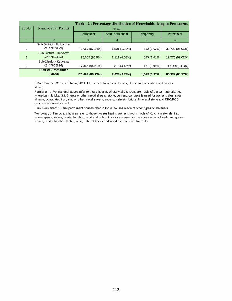
Permanent Semi permanent Temporary Permanent
1 2 3 4 5 6
1
Sub-District - Porbandar
(2447803822) 79,657 (97.34%) 1,501 (1.83%) 512 (0.63%) 33,722 (96.05%)
2
Sub-District - Ranavav
(2447803823) 23,059 (93.8%) 1,111 (4.52%) 395 (1.61%) 12,575 (92.02%)
3
Sub-District - Kutiyana
(2447803824) 17,346 (94.51%) 813 (4.43%) 181 (0.99%) 13,935 (94.3%)
District - Porbandar
(24478) 120,062 (96.23%) 3,425 (2.75%) 1,088 (0.87%) 60,232 (94.77%)
Note :
1.Data Source:-Census of India, 2011, HH- series Tables on Houses, Household amenities and assets.
Permanent : Permanent houses refer to those houses whose walls & roofs are made of pucca materials, i.e.,
where burnt bricks, G.I. Sheets or other metal sheets, stone, cement, concrete is used for wall and tiles, slate,
shingle, corrugated iron, zinc or other metal sheets, asbestos sheets, bricks, lime and stone and RBC/RCC
concrete are used for roof.
Semi Permanent : Semi permanent houses refer to those houses made of other types of materials.
Temporary : Temporary houses refer to those houses having wall and roofs made of Kutcha materials, i.e.,
where, grass, leaves, reeds, bamboo, mud and unburnt bricks are used for the construction of walls and grass,
leaves, reeds, bamboo thatch, mud, unburnt bricks and wood etc. are used for roofs.
Table - 2 : Percentage distribution of Households living in Permanent,
Sl. No. Name of Sub - District Total
112

Semi permanent Temporary Permanent Semi permanent Temporary
7 8 9 10 11 2
1,032 (2.94%) 301 (0.86%) 45,935 (98.32%) 469 (1%) 211 (0.45%) Sub-District - Porbandar (2447803822)
774 (5.66%) 303 (2.22%) 10,484 (96.02%) 337 (3.09%) 92 (0.84%) Sub-District - Ranavav (2447803823)
713 (4.83%) 117 (0.79%) 3,411 (95.39%) 100 (2.8%) 64 (1.79%) Sub-District - Kutiyana (2447803824)
2,519 (3.96%) 721 (1.13%) 59,830 (97.74%) 906 (1.48%) 367 (0.6%) District - Porbandar (24478)
Semi permanent and Temporary Houses , 2011
Urban Name of Sub-DistrictRural
113

Tap water from
treated source
Tap water from
untreated source
Covered well Un-covered well
1 2 3 4 5 6 7 8
1 Total 81,832 39,385 (48.13%) 8,511 (10.4%) 5,210 (6.37%) 12,501 (15.28%)
Rural 35,110 4,599 (13.1%) 4,321 (12.31%) 4,699 (13.38%) 12,298 (35.03%)
Urban 46,722 34,786 (74.45%) 4,190 (8.97%) 511 (1.09%) 203 (0.43%)
2 Total 24,584 11,162 (45.4%) 3,986 (16.21%) 1,864 (7.58%) 1,462 (5.95%)
Rural 13,666 5,870 (42.95%) 2,517 (18.42%) 1,405 (10.28%) 876 (6.41%)
Urban 10,918 5,292 (48.47%) 1,469 (13.45%) 459 (4.2%) 586 (5.37%)
3 Total 18,353 2,487 (13.55%) 11,959 (65.16%) 1,134 (6.18%) 1,111 (6.05%)
Rural 14,777 349 (2.36%) 10,910 (73.83%) 1,075 (7.27%) 1,059 (7.17%)
Urban 3,576 2,138 (59.79%) 1,049 (29.33%) 59 (1.65%) 52 (1.45%)
Total 124,769 53,034 (42.51%) 24,456 (19.6%) 8,208 (6.58%) 15,074 (12.08%)
Rural 63,553 10,818 (17.02%) 17,748 (27.93%) 7,179 (11.3%) 14,233 (22.4%)
Urban 61,216 42,216 (68.96%) 6,708 (10.96%) 1,029 (1.68%) 841 (1.37%)
Data Source:-Census of India, 2011, HH- series Tables on Houses, Household amenities and assets.
Table -3 : Number and Percentage of Households
Sl.
No.
Name of Sub-District Total/
Rural/
Urban
Total Number
of households
Number and percentage of Household
Note: Percentage is given in brackets after the number of households.
Sub-District - Porbandar
(2447803822)
Sub-District - Ranavav
(2447803823)
Sub-District - Kutiyana
(2447803824)
District - Porbandar
(24478)
114

Handpump Tubewell/boreh
ole
Spring River/ canal Tank/ pond/
lake
Other Sources
9 10 11 12 13 14 3 2
6,350 (7.76%) 3,782 (4.62%) 19 (0.02%) 111 (0.14%) 1,702 (2.08%) 4,261 (5.21%) Total
2,741 (7.81%) 1,125 (3.2%) 7 (0.02%) 110 (0.31%) 1,697 (4.83%) 3,513 (10.01%) Rural
3,609 (7.72%) 2,657 (5.69%) 12 (0.03%) 1 (0%) 5 (0.01%) 748 (1.6%) Urban
2,337 (9.51%) 2,650 (10.78%) 3 (0.01%) 18 (0.07%) 643 (2.62%) 459 (1.87%) Total
692 (5.06%) 1,470 (10.76%) 2 (0.01%) 17 (0.12%) 603 (4.41%) 214 (1.57%) Rural
1,645 (15.07%) 1,180 (10.81%) 1 (0.01%) 1 (0.01%) 40 (0.37%) 245 (2.24%) Urban
610 (3.32%) 510 (2.78%) 1 (0.01%) 0 (0%) 17 (0.09%) 524 (2.86%) Total
579 (3.92%) 422 (2.86%) 0 (0%) 0 (0%) 16 (0.11%) 367 (2.48%) Rural
31 (0.87%) 88 (2.46%) 1 (0.03%) 0 (0%) 1 (0.03%) 157 (4.39%) Urban
9,297 (7.45%) 6,942 (5.56%) 23 (0.02%) 129 (0.1%) 2,362 (1.89%) 5,244 (4.2%) Total
4,012 (6.31%) 3,017 (4.75%) 9 (0.01%) 127 (0.2%) 2,316 (3.64%) 4,094 (6.44%) Rural
5,285 (8.63%) 3,925 (6.41%) 14 (0.02%) 2 (0%) 46 (0.08%) 1,150 (1.88%) Urban
by main source of Drinking water, 2011.
Name of Sub-
District
having following source of drinking water Total/
Rural/
Urban
Sub-District -
Porbandar
(2447803822)
Sub-District -
Ranavav
(2447803823)
Sub-District -
Kutiyana
(2447803824)
District - Porbandar
(24478)
Note: Percentage is given in brackets after the number of households.
115

Electricity Kerosene
1 2 3 4 5 6
1 Total 81,832 77,628 (94.86%) 3,556 (4.35%)
Rural 35,110 31,734 (90.38%) 2,847 (8.11%)
Urban 46,722 45,894 (98.23%) 709 (1.52%)
2 Total 24,584 22,493 (91.49%) 1,572 (6.39%)
Rural 13,666 12,070 (88.32%) 1,135 (8.31%)
Urban 10,918 10,423 (95.47%) 437 (4%)
3 Total 18,353 16,919 (92.19%) 1,330 (7.25%)
Rural 14,777 13,593 (91.99%) 1,122 (7.59%)
Urban 3,576 3,326 (93.01%) 208 (5.82%)
Total 124,769 117,040 (93.81%) 6,458 (5.18%)
Rural 63,553 57,397 (90.31%) 5,104 (8.03%)
Urban 61,216 59,643 (97.43%) 1,354 (2.21%)
Data Source:-Census of India, 2011, HH- series Tables on Houses, Household amenities and assets.
Table- 4 : Number and Percentage of Households
Sl.
No.
Name of Sub-District Total/
Rural/
Urban
Total number
of
households
Number and Percentage of households
Note: Percentage is given in brackets after the number of households.
Sub-District - Porbandar (2447803822)
Sub-District - Ranavav (2447803823)
Sub-District - Kutiyana (2447803824)
District - Porbandar (24478)
116

Solar Other oil Any other No lighting
7 8 9 10 3 2
68 (0.08%) 116 (0.14%) 152 (0.19%) 312 (0.38%) Total
56 (0.16%) 90 (0.26%) 129 (0.37%) 254 (0.72%) Rural
12 (0.03%) 26 (0.06%) 23 (0.05%) 58 (0.12%) Urban
336 (1.37%) 33 (0.13%) 47 (0.19%) 103 (0.42%) Total
331 (2.42%) 20 (0.15%) 40 (0.29%) 70 (0.51%) Rural
5 (0.05%) 13 (0.12%) 7 (0.06%) 33 (0.3%) Urban
19 (0.1%) 8 (0.04%) 17 (0.09%) 60 (0.33%) Total
19 (0.13%) 5 (0.03%) 4 (0.03%) 34 (0.23%) Rural
0 (0%) 3 (0.08%) 13 (0.36%) 26 (0.73%) Urban
423 (0.34%) 157 (0.13%) 216 (0.17%) 475 (0.38%) Total
406 (0.64%) 115 (0.18%) 173 (0.27%) 358 (0.56%) Rural
17 (0.03%) 42 (0.07%) 43 (0.07%) 117 (0.19%) Urban
Name of Sub-District
Table- 4 : Number and Percentage of Households by main source of Lighting, 2011.
having following main source of lighting Number and Percentage of households Total/
Rural/
Urban
Sub-District - Porbandar
(2447803822)
Sub-District - Ranavav
(2447803823)
Sub-District - Kutiyana
(2447803824)
District - Porbandar (24478)
Note: Percentage is given in brackets after the number of households.
117

Pit
Piped sewer
system
Septic tank Other system With
slab/Ventilated
improved pit
1 2 3 4 5 6 7 8
1 Total 81,832 6,715 (8.21%) 33,563 (41.01%) 433 (0.53%) 10,021 (12.25%)
Rural 35,110 526 (1.5%) 5,245 (14.94%) 223 (0.64%) 6,672 (19%)
Urban 46,722 6,189 (13.25%) 28,318 (60.61%) 210 (0.45%) 3,349 (7.17%)
2 Total 24,584 412 (1.68%) 8,666 (35.25%) 188 (0.76%) 3,223 (13.11%)
Rural 13,666 183 (1.34%) 3,673 (26.88%) 132 (0.97%) 2,191 (16.03%)
Urban 10,918 229 (2.1%) 4,993 (45.73%) 56 (0.51%) 1,032 (9.45%)
3 Total 18,353 175 (0.95%) 3,385 (18.44%) 233 (1.27%) 4,557 (24.83%)
Rural 14,777 41 (0.28%) 1,554 (10.52%) 146 (0.99%) 4,000 (27.07%)
Urban 3,576 134 (3.75%) 1,831 (51.2%) 87 (2.43%) 557 (15.58%)
Total 124,769 7,302 (5.85%) 45,614 (36.56%) 854 (0.68%) 17,801 (14.27%)
Rural 63,553 750 (1.18%) 10,472 (16.48%) 501 (0.79%) 12,863 (20.24%)
Urban 61,216 6,552 (10.7%) 35,142 (57.41%) 353 (0.58%) 4,938 (8.07%)
Data Source:-Census of India, 2011, HH- series Tables on Houses, Household amenities and assets.
Note: Percentage is given in brackets after the number of households.
Sub-District - Porbandar
(2447803822)
Sub-District - Ranavav
(2447803823)
Sub-District - Kutiyana
(2447803824)
District - Porbandar (24478)
Table -5 : Number and Percentage of Households
Sl.
No.
Name of Sub-District Total/
Rural/
Urban
Total number
of households Flush/Pour latrine
Number and percentage of households
118

Latrine
Without
slab/open pit
Night soil
removed by
human
Night soil
serviced by
animals
Public Latrine Open
9 10 11 12 13 14 3 2
269 (0.33%) 358 (0.44%) 14 (0.02%) 17 (0.02%) 3,382 (4.13%) 27,060 (33.07%) Total
237 (0.68%) 13 (0.04%) 0 (0%) 3 (0.01%) 611 (1.74%) 21,580 (61.46%) Rural
32 (0.07%) 345 (0.74%) 14 (0.03%) 14 (0.03%) 2,771 (5.93%) 5,480 (11.73%) Urban
18 (0.07%) 10 (0.04%) 0 (0%) 14 (0.06%) 403 (1.64%) 11,650 (47.39%) Total
7 (0.05%) 8 (0.06%) 0 (0%) 13 (0.1%) 229 (1.68%) 7,230 (52.91%) Rural
11 (0.1%) 2 (0.02%) 0 (0%) 1 (0.01%) 174 (1.59%) 4,420 (40.48%) Urban
10 (0.05%) 5 (0.03%) 0 (0%) 1 (0.01%) 405 (2.21%) 9,582 (52.21%) Total
7 (0.05%) 5 (0.03%) 0 (0%) 1 (0.01%) 116 (0.79%) 8,907 (60.28%) Rural
3 (0.08%) 0 (0%) 0 (0%) 0 (0%) 289 (8.08%) 675 (18.88%) Urban
297 (0.24%) 373 (0.3%) 14 (0.01%) 32 (0.03%) 4,190 (3.36%) 48,292 (38.71%) Total
251 (0.39%) 26 (0.04%) 0 (0%) 17 (0.03%) 956 (1.5%) 37,717 (59.35%) Rural
46 (0.08%) 347 (0.57%) 14 (0.02%) 15 (0.02%) 3,234 (5.28%) 10,575 (17.27%) Urban
Sub-District - Porbandar
(2447803822)
Sub-District - Ranavav
(2447803823)
Sub-District - Kutiyana
(2447803824)
District - Porbandar
(24478)
Note: Percentage is given in brackets after the number of households.
by type of Latrine facility, 2011
Name of Sub-District
No latrine within premisesNight Soil
disposed into
open drain
Service Latrine
having following type of latrine facility Total/
Rural/
Urban
119

Closed drainage Open drainage No drainage
1 2 3 4 5 6 7
1 Total 81,832 7,379 (9.02%) 32,152 (39.29%) 42,301 (51.69%)
Rural 35,110 560 (1.59%) 1,205 (3.43%) 33,345 (94.97%)
Urban 46,722 6,819 (14.59%) 30,947 (66.24%) 8,956 (19.17%)
2 Total 24,584 2,144 (8.72%) 2,363 (9.61%) 20,077 (81.67%)
Rural 13,666 1,167 (8.54%) 389 (2.85%) 12,110 (88.61%)
Urban 10,918 977 (8.95%) 1,974 (18.08%) 7,967 (72.97%)
3 Total 18,353 951 (5.18%) 1,261 (6.87%) 16,141 (87.95%)
Rural 14,777 412 (2.79%) 638 (4.32%) 13,727 (92.89%)
Urban 3,576 539 (15.07%) 623 (17.42%) 2,414 (67.51%)
Total 124,769 10,474 (8.39%) 35,776 (28.67%) 78,519 (62.93%)
Rural 63,553 2,139 (3.37%) 2,232 (3.51%) 59,182 (93.12%)
Urban 61,216 8,335 (13.62%) 33,544 (54.8%) 19,337 (31.59%)
Data Source:-Census of India, 2011, HH- series Tables on Houses, Household amenities and assets.
Table -6 : Number and Percentage of Households by type of Drainage connectivity for waste water outlet , 2011
Sl. No. Name of Sub-District Total/
Rural/
Urban
Total
number of
households
Number and Percentage of households by type of drainage
connectivity for waste water outlet
Note: Percentage is given in brackets after the number of households.
Sub-District - Porbandar (2447803822)
Sub-District - Ranavav (2447803823)
Sub-District - Kutiyana (2447803824)
District - Porbandar (24478)
120

Has kitchen Does not have
kitchen
Has kitchen Does not have
kitchen
1 2 3 4 5 6 7 8 9
1 Total 81,832 55,937 (68.36%) 7,631 (9.33%) 13,308 (16.26%) 4,655 (5.69%) 301 (0.37%)
Rural 35,110 17,416 (49.6%) 3,313 (9.44%) 11,182 (31.85%) 3,084 (8.78%) 115 (0.33%)
Urban 46,722 38,521 (82.45%) 4,318 (9.24%) 2,126 (4.55%) 1,571 (3.36%) 186 (0.4%)
2 Total 24,584 15,040 (61.18%) 2,485 (10.11%) 4,950 (20.14%) 2,006 (8.16%) 103 (0.42%)
Rural 13,666 7,740 (56.64%) 1,375 (10.06%) 3,336 (24.41%) 1,163 (8.51%) 52 (0.38%)
Urban 10,918 7,300 (66.86%) 1,110 (10.17%) 1,614 (14.78%) 843 (7.72%) 51 (0.47%)
3 Total 18,353 10,678 (58.18%) 1,958 (10.67%) 4,662 (25.4%) 970 (5.29%) 85 (0.46%)
Rural 14,777 8,322 (56.32%) 1,431 (9.68%) 4,215 (28.52%) 753 (5.1%) 56 (0.38%)
Urban 3,576 2,356 (65.88%) 527 (14.74%) 447 (12.5%) 217 (6.07%) 29 (0.81%)
Total 124,769 81,655 (65.44%) 12,074 (9.68%) 22,920 (18.37%) 7,631 (6.12%) 489 (0.39%)
Rural 63,553 33,478 (52.68%) 6,119 (9.63%) 18,733 (29.48%) 5,000 (7.87%) 223 (0.35%)
Urban 61,216 48,177 (78.7%) 5,955 (9.73%) 4,187 (6.84%) 2,631 (4.3%) 266 (0.43%)
Data Source:-Census of India, 2011, HH- series Tables on Houses, Household amenities and assets.
Table -7 : Number and Percentage of Households by availablity of Kitchen facility, 2011
Sl.
No.
Name of Sub-
District
Total/
Rural/
Urban
Total
number of
households
Number and Percentage of households having kitchen
Cooking inside house Cooking outside house No cooking
Note: Percentage is given in brackets after the number of households.
Sub-District -
Porbandar
(2447803822)
Sub-District -
Ranavav
(2447803823)
Sub-District -
Kutiyana
(2447803824)
District -
Porbandar (24478)
121

Firewood Crop residue Cowdung cake Coal/ lignite/
charcoal
1 2 3 4 5 6 7 8
1 Total 81,832 30,126 (36.81%) 1,151 (1.41%) 9,728 (11.89%) 672 (0.82%)
Rural 35,110 26,067 (74.24%) 934 (2.66%) 3,670 (10.45%) 45 (0.13%)
Urban 46,722 4,059 (8.69%) 217 (0.46%) 6,058 (12.97%) 627 (1.34%)
2 Total 24,584 13,346 (54.29%) 596 (2.42%) 3,709 (15.09%) 65 (0.26%)
Rural 13,666 8,033 (58.78%) 481 (3.52%) 2,218 (16.23%) 23 (0.17%)
Urban 10,918 5,313 (48.66%) 115 (1.05%) 1,491 (13.66%) 42 (0.38%)
3 Total 18,353 10,277 (56%) 809 (4.41%) 3,227 (17.58%) 14 (0.08%)
Rural 14,777 9,138 (61.84%) 796 (5.39%) 2,544 (17.22%) 11 (0.07%)
Urban 3,576 1,139 (31.85%) 13 (0.36%) 683 (19.1%) 3 (0.08%)
Total 124,769 53,749 (43.08%) 2,556 (2.05%) 16,664 (13.36%) 751 (0.6%)
Rural 63,553 43,238 (68.03%) 2,211 (3.48%) 8,432 (13.27%) 79 (0.12%)
Urban 61,216 10,511 (17.17%) 345 (0.56%) 8,232 (13.45%) 672 (1.1%)
Data Source:-Census of India, 2011, HH- series Tables on Houses, Household amenities and assets.
Note: Percentage is given in brackets after the number of households.
Sub-District - Porbandar
(2447803822)
Sub-District - Ranavav
(2447803823)
Sub-District - Kutiyana
(2447803824)
District - Porbandar (24478)
Number and percentage of households bySl.
No.
Name of Sub-District Total/
Rural/
Urban
Total
number of
households
Table -8 : Number and Percentage of Households
122

Kerosene LPG/ PNG Electricity Bio-gas Any other No cooking
9 10 11 12 13 14 3 2
5,598 (6.84%) 33,212 (40.59%) 11 (0.01%) 998 (1.22%) 35 (0.04%) 301 (0.37%) Total
903 (2.57%) 2,616 (7.45%) 9 (0.03%) 742 (2.11%) 9 (0.03%) 115 (0.33%) Rural
4,695 (10.05%) 30,596 (65.49%) 2 (0%) 256 (0.55%) 26 (0.06%) 186 (0.4%) Urban
1,041 (4.23%) 5,495 (22.35%) 38 (0.15%) 186 (0.76%) 5 (0.02%) 103 (0.42%) Total
330 (2.41%) 2,329 (17.04%) 35 (0.26%) 163 (1.19%) 2 (0.01%) 52 (0.38%) Rural
711 (6.51%) 3,166 (29%) 3 (0.03%) 23 (0.21%) 3 (0.03%) 51 (0.47%) Urban
632 (3.44%) 2,979 (16.23%) 2 (0.01%) 328 (1.79%) 0 (0%) 85 (0.46%) Total
388 (2.63%) 1,537 (10.4%) 1 (0.01%) 306 (2.07%) 0 (0%) 56 (0.38%) Rural
244 (6.82%) 1,442 (40.32%) 1 (0.03%) 22 (0.62%) 0 (0%) 29 (0.81%) Urban
7,271 (5.83%) 41,686 (33.41%) 51 (0.04%) 1,512 (1.21%) 40 (0.03%) 489 (0.39%) Total
1,621 (2.55%) 6,482 (10.2%) 45 (0.07%) 1,211 (1.91%) 11 (0.02%) 223 (0.35%) Rural
5,650 (9.23%) 35,204 (57.51%) 6 (0.01%) 301 (0.49%) 29 (0.05%) 266 (0.43%) Urban
Sub-District - Porbandar
(2447803822)
Sub-District - Ranavav
(2447803823)
Sub-District - Kutiyana
(2447803824)
District - Porbandar
(24478)
Note: Percentage is given in brackets after the number of households.
by type of fuel used for Cooking, 2011
availability of fuel used for cooking Name of Sub-DistrictTotal/
Rural/
Urban
123

Radio/ Transistor Television Computer/ laptop-
With Internet
Computer/ laptop-
Without Internet
Land line
Telephone
1 2 3 4 5 6 7 8 9 10
1 Total 81,832 57,708 (70.52%) 12,279 (15.01%) 56,319 (68.82%) 1,344 (1.64%) 2,982 (3.64%) 2,858 (3.49%)
Rural 35,110 24,647 (70.2%) 4,460 (12.7%) 17,468 (49.75%) 106 (0.3%) 769 (2.19%) 831 (2.37%)
Urban 46,722 33,061 (70.76%) 7,819 (16.74%) 38,851 (83.15%) 1,238 (2.65%) 2,213 (4.74%) 2,027 (4.34%)
2 Total 24,584 15,083 (61.35%) 3,112 (12.66%) 14,281 (58.09%) 256 (1.04%) 727 (2.96%) 676 (2.75%)
Rural 13,666 8,698 (63.65%) 1,847 (13.52%) 7,334 (53.67%) 135 (0.99%) 441 (3.23%) 403 (2.95%)
Urban 10,918 6,385 (58.48%) 1,265 (11.59%) 6,947 (63.63%) 121 (1.11%) 286 (2.62%) 273 (2.5%)
3 Total 18,353 13,201 (71.93%) 2,131 (11.61%) 10,220 (55.69%) 53 (0.29%) 277 (1.51%) 474 (2.58%)
Rural 14,777 11,224 (75.96%) 1,847 (12.5%) 7,865 (53.22%) 27 (0.18%) 170 (1.15%) 373 (2.52%)
Urban 3,576 1,977 (55.29%) 284 (7.94%) 2,355 (65.86%) 26 (0.73%) 107 (2.99%) 101 (2.82%)
Total 124,769 85,992 (68.92%) 17,522 (14.04%) 80,820 (64.78%) 1,653 (1.32%) 3,986 (3.19%) 4,008 (3.21%)
Rural 63,553 44,569 (70.13%) 8,154 (12.83%) 32,667 (51.4%) 268 (0.42%) 1,380 (2.17%) 1,607 (2.53%)
Urban 61,216 41,423 (67.67%) 9,368 (15.3%) 48,153 (78.66%) 1,385 (2.26%) 2,606 (4.26%) 2,401 (3.92%)
Table -9 : Number and Percentage of Households availing Banking services and number of Households having each of the specified assets in, 2011
Total
number
of
household
s
Total number of
households availing
banking services
Number and percentage of households having each of the following specified assetsSl.
No.
Name of Sub-
District
Total/
Rural/
Urban
Data Source:-Census of India, 2011, HH- series Tables on Houses, Household amenities and assets.
Note: Percentage is given in brackets after the number of households.
Sub-District -
Porbandar
(2447803822)
Sub-District -
Ranavav
(2447803823)
Sub-District -
Kutiyana
(2447803824)
District -
Porbandar
(24478)
124

Mobile Telephone Both Land line
and
MobileTelephone
Bicycle Scooter/ Motor Cycle/
Moped
Car/ Jeep/ Van None of the
specified asset
11 12 13 14 15 16 3 2
54,609 (66.73%) 4,909 (6%) 29,732 (36.33%) 32,021 (39.13%) 3,195 (3.9%) 9,307 (11.37%) Total
23,848 (67.92%) 1,200 (3.42%) 9,010 (25.66%) 11,836 (33.71%) 1,017 (2.9%) 6,113 (17.41%) Rural
30,761 (65.84%) 3,709 (7.94%) 20,722 (44.35%) 20,185 (43.2%) 2,178 (4.66%) 3,194 (6.84%) Urban
15,412 (62.69%) 1,090 (4.43%) 7,061 (28.72%) 7,574 (30.81%) 877 (3.57%) 4,333 (17.63%) Total
8,297 (60.71%) 598 (4.38%) 3,161 (23.13%) 4,599 (33.65%) 459 (3.36%) 2,781 (20.35%) Rural
7,115 (65.17%) 492 (4.51%) 3,900 (35.72%) 2,975 (27.25%) 418 (3.83%) 1,552 (14.22%) Urban
11,964 (65.19%) 723 (3.94%) 3,991 (21.75%) 5,561 (30.3%) 323 (1.76%) 3,221 (17.55%) Total
9,607 (65.01%) 572 (3.87%) 3,150 (21.32%) 4,645 (31.43%) 222 (1.5%) 2,634 (17.82%) Rural
2,357 (65.91%) 151 (4.22%) 841 (23.52%) 916 (25.62%) 101 (2.82%) 587 (16.41%) Urban
81,985 (65.71%) 6,722 (5.39%) 40,784 (32.69%) 45,156 (36.19%) 4,395 (3.52%) 16,861 (13.51%) Total
41,752 (65.7%) 2,370 (3.73%) 15,321 (24.11%) 21,080 (33.17%) 1,698 (2.67%) 11,528 (18.14%) Rural
40,233 (65.72%) 4,352 (7.11%) 25,463 (41.6%) 24,076 (39.33%) 2,697 (4.41%) 5,333 (8.71%) Urban
number of Households having each of the specified assets in, 2011
having each of the following specified assets Name of Sub-
District
Total/
Rural/
Urban
Sub-District -
Porbandar
(2447803822)
Sub-District -
Ranavav
(2447803823)
Sub-District -
Kutiyana
(2447803824)
District -
Porbandar
(24478)
Note: Percentage is given in brackets after the number of households.
125


ORGI-GUJARAT English – (10-2011)
Directorate of Census Operations, Gujarat Census Bhawan, Sector – 10/A,
Gandhi Nagar-382043
Email: [email protected] Website: http://www.censusindia.gov.in