center for international trade and agriculture (cita) · center for international trade and...
TRANSCRIPT
Center for International Trade and Agriculture (CITA)
CITA WORKING PAPER #1-2010
INTERNATIONAL LEGAL REGIMES TO BALANCE THE PROTECTION OF PRAIRIES AND GRASSLANDS WITH THEIR AGRICULTURAL USE
PART ONE – GRASSLANDS AT RISK
Editor’s Note. The University of Kansas School of Law initiated the operations of the Center for International Trade and Agriculture (“CITA”) in early 2010 with an inaugural symposium held in Lawrence, Kansas. Now, as of September 2010, another element of the CITA’s expanding operations is being put in place: the CITA Working Papers Series. The overall aim of the CITA Working Papers Series is to provide a forum in which interesting information and insights on a broad range of issues that lie at the intersection of three subjects – international trade, agriculture, and law – can be expressed and discussed in a manner that will benefit legal practitioners, policy-makers, academics, and those members of the general public who are interested in a thoughtful exchange of views on these issues. For more information about the CITA Working Papers Series, including a set of “Guidelines for Contributions to the CITA Working Papers Series”, see the CITA website – http://www.law.ku.edu/~kulaw/centers/cita/index.shtml. As explained there, the contributions to the CITA Working Papers Series are intended to be just that: “working” papers. In other words, a contribution to the Series need not provide a completely polished “last word” on the author’s views but can be a work-in-progress offered in the hope that readers and other contributors will offer comments and responses. This first contribution to the CITA Working Papers Series constitutes a beginning installment of findings emerging from a book project that concentrates on a part of the Earth’s natural environment that is absolutely central to agriculture – prairies and grasslands. The title of this CITA Working Paper #1-2010 is INTERNATIONAL LEGAL REGIMES TO BALANCE THE PROTECTION OF PRAIRIES AND GRASSLANDS WITH THEIR AGRICULTURAL USE: PART ONE – GRASSLANDS AT RISK. Comments are welcome, particularly in the form of either (i) direct communications with the author ([email protected]) or (ii) submission of a contribution to the CITA Working Papers Series on this or a related topic.
* * * * * * *

2
INTERNATIONAL LEGAL REGIMES TO BALANCE THE PROTECTION OF PRAIRIES AND GRASSLANDS
WITH THEIR AGRICULTURAL USE
PART ONE – GRASSLANDS AT RISK
John W. Head *
S y n o p s i s
Grasslands abound on Earth, but humans have damaged them profoundly. This paper – part of a book project focusing on the international legal regimes needed to strike an appropriate balance between the protection of grassland areas and their use for agricultural production – identifies where grasslands are located, what makes them distinct parts of our natural order, how they have been degraded, and why that matters. Some points that are fundamental to this discussion include these: (1) grassland ecoregions exist both in tropical and in temperate zones of the Earth, and while there are important differences both between and within each of these two categories of grasslands, their similarities warrant looking at the two together; (2) grasslands are dramatically more complex and full of life than most people realize, and indeed the subtlety of their richness probably contributes to their abuse; (3) that abuse takes many forms and springs from many causes, including urban encroachment, forest encroachment (especially through fire suppression), habitat fragmentation, agricultural conversion, inappropriate grazing practices, water mismanagement, and recreational frivolity; and (4) human abuse of the world’s grasslands incurs a huge economic and financial cost to this and future generations, in part because it squanders the benefits that grasslands can provide by way of protecting water quality, buffering drastic natural phenomena (such as storms and floods), conserving soil resources, facilitating prudent recreation, maintaining critical habitat for wildlife, protecting biodiversity more generally, and contributing to the global food supply through sustainable use in agricultural and livestock operations.
The condition and use of grasslands around the world have a direct bearing on agricultural production and on the international trade in agricultural commodities that is essential for the Earth’s future. Hence this paper offers a factual foundation for legal and policy discussions; one or more later papers by the same author will contribute further to those discussions.
_________________________
* John Head is the Robert W. Wagstaff Distinguished Professor of Law at the University of Kansas. Before beginning an academic career, Mr. Head held a judicial clerkship, practiced law in the Washington office of Cleary, Gottlieb, Steen and Hamilton, and served as legal counsel for both the Asian Development Bank and the International Monetary Fund. His teaching and his scholarly publications concentrate in the areas of public international law, international economic law and institutions, and comparative law. - CITA Working Paper #1-2010 -

3
O u t l i n e
Introduction . . . . . . . . . . . 4
IA. Locations of Grasslands in the World . . . . . . . . . . . 6 IA1. In General Terms . . . . . . . . . . . 6 IA2. The WWF Classification System . . . . . . . . . . . 8 IA3. A Summary and Some Illustrations . . . . . . . . . . . 15 IA3a. The Central and Southern Mixed Grasslands – Ecoregion #NA0803 IA3b. The Patagonian Steppe – Ecoregion #NT0805 IA3c. The West Sudanian Savanna – Ecoregion #AT0722 IA3d. The Western Gulf Coastal Grasslands – Ecoregion #NA0701 IB. Definitions and Descriptions . . . . . . . . . . . 24 IB1. Biomes, Ecoregions, and Realms . . . . . . . . . . . 24 IB1a. Biomes IB1b. Biogeographical Realms IB1c. Ecoregions IB2. Grasslands, Savannas, Shrublands, and Prairies . . . . . . . . . . . 34 IC. Why Are The Grasslands at Risk? . . . . . . . . . . . 46 IC1. Inappropriate Grazing Practices . . . . . . . . . . . 47 IC2. Conversion to Agricultural Use . . . . . . . . . . . 48 IC3. Urban Development . . . . . . . . . . . 49 IC4. Habitat Fragmentation . . . . . . . . . . . 51 IC5. Fire Suppression . . . . . . . . . . . 52 IC6. Forest Encroachment . . . . . . . . . . . 52 IC7. Other Forms of Species Invasion . . . . . . . . . . . 53 IC8. Water Mismanagement . . . . . . . . . . . 54 IC9. Global Warming . . . . . . . . . . . 57 IC10. Recreational Frivolity . . . . . . . . . . . 58 IC11. The Cocktail of Doom . . . . . . . . . . . 60 ID. What Good are Grasslands? . . . . . . . . . . . 64 ID1. Soil Conservation . . . . . . . . . . . 64 ID2. Biological Diversity . . . . . . . . . . . 64 ID3. Animal Habitat . . . . . . . . . . . 65 ID4. Municipal Infrastructure Functions . . . . . . . . . . . 66 ID5. Community Economic Development . . . . . . . . . . . 67 ID6. Recreation and Tourism . . . . . . . . . . . 68 ID7. Food Supply – Local and Global . . . . . . . . . . . 68 Concluding Observations . . . . . . . . . . . 69
Appendix Temperate and Tropical Grassland Ecoregions of the World – Selected Data . . . . . . . . . . . 71
* * * * * * *
4
Introduction
I was raised on a farm in the isolated and provincial northeast corner of Missouri, in the
heartland of the United States. The farm lay in two tracts – one on the east edge and one on the
west edge of a farm-based community of about three thousand people – and it formed part of a
large patchwork of farms carved out of native woodland and grassland that rose up from the
Mississippi River valley and extended east along the glacial plain of north Missouri. My parents
and my brother and I called the west part of our farm “the Prairie”, a label probably given to it by
my father’s father after he and my grandmother acquired it from other members of our extended
family, all of whom had settled in the region in the early 1800s as part of the earliest wave of
what became permanent European encroachment on Native American lands.
I found “the Prairie” a dull place. It had no trees, except in fencerows dividing it into
fields. It had no ponds, except in a boggy spot we tried to drain. It had no life that my eye could
see, but for birds and snakes and bugs.
And so I scarcely thought of “the Prairie” once I left home for the state university and
then on to graduate studies overseas. My interests took me into law, particularly international
law, and I embarked on a career that found me living in Manila, Washington, London, Beijing,
and other cities. The path led into an academic appointment, and it is from that perspective that,
for the past twenty years, I have continued to explore topics in those areas that intrigue me most.
These are, in a nutshell, the international legal aspects of (i) economic development, (ii)
environmental protection, and (iii) legal history, with a side interest in Chinese law.
To my great good fortune, the academic appointment I have held throughout this part of
my career has been at the University of Kansas, in Lawrence, Kansas. Besides its intriguing
political and cultural history, Lawrence enjoys a remarkable natural history as well – sitting as it
does at the edge of the vast Great Plains of North America. When University of Kansas
basketball fans “wave the wheat” in support of their team, they recreate in human form the same
patterns of undulating grass moving with the breezes and winds that caress the great grasslands
that grace much of Kansas, Oklahoma, Nebraska, and states and provinces further north.

5
Thus did I find myself back in touch with the prairie, a small portion of which I had
known as a boy in the form of “the Prairie” on our family farm. That Missouri farm is still in our
family, and now my wife and I own a Kansas farm as well – on which we are currently engaged
in a prairie restoration project to reclaim about 50 acres of land, once native prairie, from a
degraded condition visited on it by farming, species invasion, erosion, and other abuse.
Why do I tell this personal story? Because it sets the stage for an explanation of why I
have engaged in a substantial research project regarding prairies and grasslands. Having worked
for most of my career with issues of international economic development and international
environmental protection, I see the two topics as inextricably – I would even say elegantly –
intertwined. In my view, sustainable global economic improvement, or even survival, depends
crucially on both (i) adequate production and distribution of food and (ii) environmental
consciousness and husbandry; we must protect the natural environment from human degradation
if we are to have any hope of avoiding economic degradation in coming years, as human
populations relentlessly increase in size and appetite. This perspective, gained from about thirty
years of legal practice and study, now complements my own personal connection to grasslands –
both now and from my childhood – to fuel an interest in the appropriate preservation and use of
those grasslands, not just in the Great Plains of North America but elsewhere in the world as
well.
As I have pursued this interest, I have found that my earlier impressions were almost
entirely false. Contrary to my impression that “the Prairie” of my childhood was a dull and
rather lifeless place, I have now gained an appreciation for the extraordinary complexity,
durability, diversity, and subtlety of the prairies. As I shall try to convey in this paper (and in the
larger written product that I expect to emerge from my studies), the prairies – or “grasslands”, or
“savannas”, or “shrublands”, all terms that are more or less interchangeably descriptive
depending on circumstances – constitute a part of the Earth’s natural environment (and therefore
of our human environment) that is of enormous importance in keeping the entire natural system
in balance.
But they are in peril. My research work so far has drawn my attention to the damage
already done to Earth’s grasslands. Indeed, in many regions of the world the degradation and

6
disappearance of this part of our natural system is nearly complete. Through urbanization,
species encroachment, land conversion, genetic pollution, fragmentation, and climate change –
all facilitated by a toxic brew of ignorance, arrogance, and greed – the grasslands have withered
and contracted all over the world. These are topics addressed in this paper.
In follow-up research and writing, I intend to explore what has been done so far, at both
the national level and at the global level, to arrest and counteract this trend by employing legal
and institutional instruments. My initial impression is that the answer is “not much”. While a
few protective measures have been taken in a few countries, grasslands have gotten dramatically
less attention than some other parts of the natural environment. I wish to explore that matter
further, in part by examining population trends (both worldwide and in prairie regions) and what
I regard as the growing gulf between technology and understanding.
My ultimate goal is to sketch out a “program of action” that focuses specifically on
grasslands – with special attention to temperate grasslands (prairies) – in order to help protect
them and the people who need them. Naturally, my principal perspective in doing so is legal in
character. That is, whatever program of action I might propose will involve the strengthening of
existing legal rules and institutions, the possible creation of new legal mechanisms, and a more
long-range approach to accomplishing what the title of this paper suggests: balancing (i) the
protection of grasslands and prairies with (ii) their agricultural use.
IA. Locations of Grasslands in the World
IA1. In General Terms
The world’s grasslands have been the subject of several exercises in identification and
delineation. Naturally, any particular effort to determine the precise extent and locations of
grasslands will depend on the definition(s) used. I shall defer a discussion of that point
(definitions) until section IB, below. That discussion will also explain the important differences
between, but general similarity in, the terms “grasslands” and “savannas” and “shrublands” – and
various other related terms – along with my reason for preferring the term “prairie” in certain

7
circumstances, even though that term is less familiar outside North America than are some of the
other terms.
Before turning to those technical matters, however, I wish to offer an abbreviated answer
– or series of answers – to this central question: “Where are the world’s grasslands?”
In the most general terms, the world’s grasslands lie in two areas of the world: those with
temperate climates and those with tropical climates. Hence we see a fundamental distinction
(found throughout the literature on the subject) between “temperate grasslands” and “tropical
grasslands”. (Sometimes the latter of these is referred to as “tropical and subtropical”
grasslands, as many of the non-temperate grasslands, particularly those in Australia, do not
technically lie within the tropics.) Map #1.1 shows – also in very general terms – the locations
of the largest of these two types of grasslands.
Map #1.1. General distribution of principal temperate and tropical grasslands
Legend : regions in black shading = temperate grasslands, savannas, and shrublands regions in gray shading = tropical & subtropical grasslands, savannas, and shrublands XXX [ NOTE – This map is to be improved, with further attention to the details of the outlines of WWF ecoregions.]

8
With this as a starting point, we can consider a slightly more refined answer to the
question “where are the world’s grasslands?”. One authority offers an explanatory note and then
a listing of the world’s principal grassland areas. The explanatory note discusses the term
“natural” grassland:
The term ‘natural’ grassland is considered by some biogeographers to be a contradiction of terms, claiming that almost every grassland owes its origin to human management and therefore, cannot be described as ‘natural’. There are, however, some grasslands that have been in existence for many thousands of years and have taken on the apparance [sic] of ‘natural’ grasslands. The term ‘old’ grassland should be used in place of ‘natural’ grassland.1
With this explanation, that authority provides this summary of the location of the world’s “old”
grasslands:
The main temperate grasslands include: • The North American Prairies; • The Pampas of Argentina; • The Steppes of Russia; • The Veldt of South Africa, and • The Plains of New Zealand.
. . . [On the other hand, tropical grasslands abound in Africa, where they are typically called “savannas”.] Savannas (also sometimes spelled savana and savannah) are located much nearer the equator than the temperate grasslands. In Africa, the savannas cross the equator in the vicinity of the East African highlands, uniting the northern and southern hemisphere grassland units. Typically, the savannas occupy latitudes between 5° and 20° N[orth] and S[outh] of the equator.2
IA2. The WWF Classification System
A much more precise answer can also be given to the question “where are the world’s
grasslands?”. This answer draws from an effort of about a decade ago that was sponsored by the
1 See Grasslands Conservation Council of British Columbia, Overview of the World’s Grasslands, at http://www.bcgrasslands.org/library/world.htm (attributing the text to the Geogrraphy Department at the University of Strathclyde in Glasgow, Scotland) [hereinafter Grasslands Overview]. 2 Id. (emphasis added).

9
World Wildlife Fund (“WWF”) and was summarized in an article appearing in the November
2001 issue of the journal BioScience.3 (Because the majority of the authors of the article were, at
the time of publication, conservation scientists in the Conservation Science Program at the US
offices of the WWF, I shall refer to the classification system they described there as “the WWF
classification system”.) According to the article’s authors, this “new global map of terrestrial
ecoregions” was designed in part to provide “an innovative tool for conserving biodiversity”.4 It
identifies over 800 specific “ecoregions” in the world as a whole. Of those, 92 are grasslands.
Of those 88 ecoregions, 49 are tropical and 43 are temperate in character.
Box #1A provides an abbreviated version of the details included in the 2001 WWF
classification system for both temperate and tropical grasslands, savannas, and shrublands. The
temperate grasslands are listed first, both by general location – what the WWF system calls
“realms”, which are roughly similar to continents (although somewhat different from the ones we
are accustomed to) – and then by specific “ecoregion”. The tropical grasslands are listed second.
In each case, the WWF system “code number” for the ecoregion is also listed, along with the
total area and population of that ecoregion, plus an indication of what proportion of the
ecoregion enjoys some sort of government protection (in the form of a nature reserve, wilderness
area, protected landscape, or conservation area).
All of the details appearing in Box #1.1, along with other information about animal
species, temperature, precipitation, and population density, are provided also in a spreadsheet
format in the Appendix to this paper.
3 David M. Olson, D. Eric Dinerstein, Eric D. Wikramanayake, Neil D. Burgess, George V. N. Powell, Emma C. Underwood, Jennifer A. D'amico, Illanga Itoua, Holly E. Strand, John C. Morrison, Colby J. Loucks, Thomas F. Allnutt, Taylor H. Ricketts, Yumiko Kura, John F. Lamoreux, Wesley W.Wettengel, Prashant Hedao, & Kenneth R. Kassem, Terrestrial Ecoregions of the World: A New Map of Life on Earth, 51 BIOSCIENCE 933 (2001). See http://www.worldwildlife.org/science/ecoregions/delineation.html. 4 Id. at 933.

10
Box #1.1. Summary information on the world’s grasslands, savannas, and shrublands 5 Temperate grasslands, savannas, and shrublands location and ecoregion WWF # total area 1995 population % protected . . . in the Australasia “realm” (mainly Australia, New Zealand, New Guinea, Sulawesi) • Cantebury-Otago tussock grasslands #AA0801 53,593.9 km2 602,127 3.09% • Eastern Australia mulga shrublands #AA0802 253,515.5 km2 13,686 0% • Southeast Australia temperate savanna #AA0803 321,998.8 km2 387,220 0% totals in the Australasia “realm” 629,108.2 km2 1,003,033 . . . in the Afrotropic “realm” (i.e., sub-Saharan Africa) • Al Hajar montane woodlands #AT0801 25,485.3 km2 349,114 0% • Amsterdam and Saint-Paul Islands temperate grasslands #AT0802 69.2 km2 0 0% • Tristan Da Cunha-Gough Islands shrub and grasslands #AT0803 167.4 km2 0 0% totals in the Afrotropic “realm” 25,721.9 km2 349,114 . . . in the Nearctic “realm” (i.e., North American as far south as southern Mexico) • California Central Valley grasslands #NA0801 55,084.3 km2 5,066,390 0.72% • Canadian Aspen forests and parklands #NA0802 399,038.6 km2 2,349,620 1.49% • Central and Southern mixed grasslands #NA0803 282,267.4 km2 3,146,680 0.32% • Central forest-grasslands transition #NA0804 407,235.3 km2 21,518,200 0.37% • Central tall grasslands #NA0805 248,867.0 km2 4,812,080 0.14% • Edwards Plateau savanna #NA0806 61,733.7 km2 884,124 0.04% • Flint Hills tall grasslands #NA0807 29,632.1 km2 255,517 0% • Montana Valley and Foothill grasslands #NA0808 81,929.0 km2 942,133 7.09% • Nebraska Sand Hills mixed grasslands
5 Details appearing in Box #1.1 are drawn from the comprehensive spreadsheet of information relating to all of the 867 ecoregions identified in the WWF classification system. See Terrestrial Ecoregions Database at http://www.worldwildlife.org/science/ecoregions/item1267.html.

11
Temperate grasslands, savannas, and shrublands location and ecoregion WWF # total area 1995 population % protected #NA0809 61,212.4 km2 83,309 2.29% • Northern mixed grasslands #NA0810 219,614.4 km2 1,114,210 0.74% • Northern short grasslands #NA0811 640,108.5 km2 1,108,300 5.96% • Northern tall grasslands #NA0812 76,259.4 km2 1,183,210 1.75% • Palouse grasslands #NA0813 46,992.6 km2 321,040 6.99% • Texas blackland prairies #NA0814 50,214.8 km2 5,681,120 0.27% • Western short grasslands #NA0815 435,312.9 km2 4,748,670 3.18% totals in the Nearctic “realm” 3,095,502.4 km2 53,214,603 . . . in the Neotropic “realm” (i.e., south and central America, up to southern Mexico) • Espinal #NT0801 298,734.7 km2 3,881,020 0.23% • Humid Pampas #NT0803 398,554.5 km2 18,498,900 0.18% • Low Monte #NT0802 353,639.7 km2 2,610,320 1.75% • Patagonian steppe #NT0805 576,598.8 km2 560,269 4.25% totals in the Neotropic “realm” 1,627,527.7 km2 25,550,509 . . . in the Palearctic “realm” (Europe, North Africa, Mideast, Russia, North China, etc.) • Alai-Western Tian Shan steppe #PA0801 127,683.1 km2 14,254,800 0.27% • Altai steppe and semi-desert #PA0802 83,191.9 km2 640,070 0.01% • Central Anatolian steppe #PA0803 24,934.2 km2 1,485,160 0% • Daurian forest steppe #PA0804 209,634.3 km2 1,046,120 4.1% • Eastern Anatolian montane steppe #PA0805 168,381.7 km2 11,045,500 2.81% • Emin Valley steppe #PA0806 65,134.5 km2 486,618 0.22% • Faroe Islands boreal grasslands #PA0807 1,456.8 km2 33,882 0% • Gissaro-Alai open woodlands #PA0808 168,155.8 km2 10,747,500 6.98% • Kazakh forest steppe

12
Temperate grasslands, savannas, and shrublands location and ecoregion WWF # total area 1995 population % protected #PA0809 422,308.2 km2 8,773,160 6.25% • Kazakh steppe #PA0810 807,556.8 km2 8,641,280 1.28% • Kazakh upland #PA0811 72,199.5 km2 334,877 0.14% • Middle East steppe #PA0812 132,288.4 km2 8,050,820 0% • Mongolian-Manchurian grassland #PA0813 889,460.1 km2 25,974,700 4.53% • Pontic steppe #PA0814 997,072.7 km2 46,517,600 2.73% • Sayan Intermontane steppe #PA0815 34,057.0 km2 151,402 10.74% • Selenge-Orkhon forest steppe #PA0816 228,368.9 km2 633,308 4.02% • South Siberian forest steppe #PA0817 162,600.1 km2 4,157,020 5.5% • Tian Shan foothill arid steppe #PA0818 129,231.2 km2 3,843,470 5.57% totals in the Palearctic “realm” 4,723,715.2 km2 146,817,287
aggregate totals for temperate grassland ecoregions 10,101,575km2 approx. 227m
Tropical grasslands, savannas, and shrublands location and ecoregion WWF # total area 1995 population % protected . . . in the Australasia “realm” (mainly Australia, New Zealand, New Guinea, Sulawesi) • Arnhem Land tropical savanna #AA0701 157,509.1 km2 102,494 1.24% • Brigalow tropical savanna #AA0702 341,561.5 km2 425,136 0.08% • Cape York Peninsula tropical savanna #AA0703 115,895.8 km2 13,673 2.92% • Carpentaria tropical savanna #AA0704 358,464.2 km2 24,988 0% • Einasleigh upland savanna #AA0705 128,067.4 km2 37,173 0% • Kimberly tropical savanna #AA0706 346,656.0 km2 38,034 0% • Mitchell grass downs #AA0707 459,496.1 km2 43,043 0%

13
Tropical grasslands, savannas, and shrublands location and ecoregion WWF # total area 1995 population % protected • Trans Fly savanna and grasslands #AA0708 26,618.2 km2 45,299 28.77% • Victoria Plains tropical savanna #AA0709 224,881.4 km2 2,854 0% totals in the Australasia “realm” 2,159,149.7 km2 732,694 . . . in the Afrotropic “realm” (i.e., sub-Saharan Africa) • Angolan Miombo woodlands #AT0701 657,515.5 km2 5,026,320 5% • Angolan Mopane woodlands #AT0702 133,028.0 km2 755,502 12.1% • Ascension scrub and grasslands #AT0703 93.0 km2 0 0% • Central Zambezian Miombo woodlands #AT0704 1,179,319.1 km2 21,708,300 11.28% • East Sudanian savanna #AT0705 913,702.0 km2 11,361,800 12.04% • Eastern Miombo woodlands #AT0706 482,012.7 km2 9,541,160 12.28% • Guinean forest-savanna mosaic #AT0707 670,789.9 km2 39,022,300 2.61% • Itigi-Sumbu thicket #AT0708 7,809.2 km2 106,610 41.02% • Kalahari Acacia-Baikiaea woodlands #AT0709 334,544.8 km2 1,264,910 10.99% • Mandara Plateau mosaic #AT0710 7,478.5 km2 792,966 0.22% • Northern Acacia-Commiphora bushlands and thickets #AT0711 324,481.6 km2 10,894,800 17.51% • Northern Congolian forest-savanna mosaic #AT0712 705,005.8 km2 7,163,590 12.95% • Sahelian Acacia savanna #AT0713 3,042,451.4 km2 33,761,400 2.17% • Serengeti volcanic grasslands #AT0714 17,947.6 km2 368,809 30.1% • Somali Acacia-Commiphora bushlands and thickets #AT0715 1,049,300.8 km2 12,430,800 10.89% • Southern Acacia-Commiphora bushlands and thickets #AT0716 226,769.7 km2 11,969,900 14.49% • Southern Africa bushveld #AT0717 222,541.1 km2 7,621,370 3.11% • Southern Congolian forest-savanna mosaic #AT0718 567,187.3 km2 12,020,900 3.47% • Southern Miombo woodlands #AT0719 406,913.3 km2 12,796,800 8.7%

14
Tropical grasslands, savannas, and shrublands location and ecoregion WWF # total area 1995 population % protected • St. Helena scrub and woodlands #AT0720 130.0 km2 4,949 0% • Victoria Basin forest-savanna mosaic #AT0721 165,041.8 km2 21,711,000 9.21% • West Sudanian savanna #AT0722 1,631,859.8 km2 74,421,900 4.82% • Western Congolian forest-savanna mosaic #AT0723 411,615.4 km2 11,724,600 3.02% • Western Zambezian grasslands #AT0724 33,889.7 km2 121,623 43.85% • Zambezian and Mopane woodlands #AT0725 471,873.7 km2 8,153,700 23.51% • Zambezian Baikiaea woodlands #AT0726 263,554.2 km2 947,327 19.39% totals in the Afrotropic “realm” 13,926,855.9 km2 315,693,336 . . . in the Indo-Malay “realm” (South Asia, Southeast Asia, southern China, to Borneo & Java) • Terai-Duar savanna and grasslands #IM0701 34,523.9 km2 13,008,100 9.65% totals in the Indo-Malay “realm” 34,523.9 km2 13,008,100 . . . in the Nearctic “realm” (i.e., North American as far south as southern Mexico) • Western Gulf coastal grasslands #NA0701 80,514.6 km2 5,924,780 2.35% totals in the Nearctic “realm” 80,514.6 km2 5,924,780 . . . in the Neotropic “realm” (i.e., south and central America, up to southern Mexico) • Beni savanna #NT0702 125,589.1 km2 154,487 0.83% • Campos Rupestres montane savanna #NT0703 26,313.0 km2 821,449 4% • Cerrado #NT0704 1,910,037.9 km2 22,365,400 1.05% • Clipperton Island shrub and grasslands #NT0705 28.8 km2 0% • Dry Chaco #NT0210 786,789.5 km2 3,777,470 6.88% • Guianan savanna #NT0707 104,493.8 km2 231,712 32.8% • Humid Chaco #NT0708 291,590.2 km2 4,059,640 4.58% • Llanos #NT0709 375,786.5 km2 2,639,750 6.44%

15
Tropical grasslands, savannas, and shrublands location and ecoregion WWF # total area 1995 population % protected • Uruguayan savanna #NT0710 352,496.3 km2 8,845,170 0.14% totals in the Neotropic “realm” 3,973,125.1 km2 42,895,078 . . . in the Oceania “realm” • Hawaii tropical high shrublands #OC0701 1,847.6 km2 8,226 16.02% • Hawaii tropical low shrublands #OC0702 1,517.5 km2 98,853 1.13% • Northwestern Hawaii scrub #OC0703 14.7 km2 0 97.33% • totals in the Oceania “realm” 3,379.8 km2 107,079 aggregate totals for tropical grassland ecoregions 22,336,696km2 approx. 378m
XXX [ NOTE – Some review and checking of details in this table needs to be undertaken. ] IA3. A Summary and Some Illustrations
Taken together, the information in Box #1.1 offers a detailed snapshot answering the question “where are the world’s grasslands?”. I would offer this summary: • Large areas of temperate grasslands are found in North America (3.1m km2), in
Argentina, in the steppes of Central Asia, and in southeastern Australia. • In North America, the temperate grasslands occur in the Great Plains region of North
America, covering vast swaths of the states of Texas, Arkansas, Kansas, Nebraska, and the Dakotas, and extending into the Canadian provinces of Manitoba, Alberta, and British Columbia – with some sizeable tracts appearing also in California and some in Mexico. These North American temperate grasslands account for roughly 30% of the world’s temperate grasslands.
• Large areas of tropical grasslands are found in Africa. There they cover a total of nearly
14 million km2 (a slightly greater area than all of the world’s temperate grasslands combined). These African tropical grasslands form a broad belt stretching nearly across the African continent, not only in the middle of the continent (that is, just south of the Sahara) but also further south below the equatorial forests. Other sizeable areas of tropical grasslands are found in Australia and in South America, especially Brazil.

16
• In aggregate, grasslands occupy roughly 32 million square kilometers – although of course large portions of them have now been degraded, a topic explored later in this book. Of this aggregate area, nearly 10 million square kilometers fall in the category of temperate grasslands, and about 22 million square kilometers fall in the category of tropical grasslands
• These grassland areas are home to many millions of people around the globe – about 227
million in temperate grassland areas and about 378 million in tropical grassland areas. • Overall, only a miniscule proportion of the grasslands – whether temperate or tropical –
have been subjected to official (government-related) protection regimes. In Australia, for example, less than 0.3% (three-tenths of one percent) of the temperate grasslands enjoy such protection, and in South America about 2.5% of the temperate grasslands enjoy such protections.
For illustrative purposes, let us examine four examples of grassland ecoregions – two
temperate and two tropical. I have selected one temperate grassland ecoregion from North
America (in what the WWF classification system refers to as the “Nearctic realm”), one
temperate grassland ecoregion from Australia (the “Australasia realm”, in WWF parlance), one
tropical grassland ecoregion from North America, and one tropical grassland ecoregion from
sub-Saharan Africa (the “Afrotropic realm”, in WWF parlance).
IA3a. The Central and Southern Mixed Grasslands – Ecoregion #NA0803
The “Central and Southern Mixed Grasslands” ecoregion – #NA0803 in the WWF
classification system – amounts to about 280,000 square kilometers ranging from west central
Texas north to the middle of Nebraska. As can be seen in Map #1.2, this ecoregion occupies
roughly half of Kansas.6 As of 1995 (the most recent year for which data are available under the
6 Another, much smaller, portion of Kansas is occupied by the Flint Hills Tall Grasslands ecoregion, which is familiar territory to my University of Kansas friends who travel from Lawrence to Wichita. The WWF website makes these observations about this ecoregion:
The Flint Hills Tall Grasslands covers the Flint Hills of Kansas and the Osage Plains of northeastern Oklahoma. The Flint Hills Tall Grasslands is the smallest grassland ecoregion in North America. It can be distinguished from other grassland associations by the dominance of tallgrass species – and from the Central Tall Grasslands to the north by its more depauperate biota and a thin soil layer spread over distinct beds of limestone. These flinty beds of limestone, from which the name of this ecoregion is derived, rendered large areas unsuitable for corn or wheat farming. Today, the Flint Hills Tall Grasslands is an anomaly – an essentially unplowed (although heavily grazed) remnant of the tallgrass prairie. Historically, fire, drought and grazing by bison (Bison bison) and other ungulates were the principle [sic] sources of habitat disturbance in this ecoregion. A new tallgrass prairie national park has been established covering about 44 km2. This ecoregion offers the best opportunity for restoration of tallgrass prairie in the United States [citing Madson 1993].

17
WWF classification system), over three million people lived within the ecoregion, along with 17
species of amphibians, 67 species of reptiles, 86 species of mammals, and 228 species of birds.
Four of those amphibian species, nine of the reptile species, three of the mammal species, and
one of the bird species can be found only in this ecoregion.7 The ecoregion ranges in elevation
from 243 meters to 1,074 meters, and it has an average annual temperature of 13.43°C (56.2°F)
with a standard deviation of 9.87°C. Its rainfall averages 647.3 millimeters (25.5 inches) per
year. Roughly half of the ecoregion (nearly 140,000 square kilometers) was estimated to be
devoted to agricultural use,8 and about 2,570 square kilometers constituted urban areas. The
ecoregion’s average “human footprint” calculated under the WWF system was 20.3 on a scale of
1 to 100 – the third largest of the four illustrations offered here. As noted above in Box #1.1
(where a few other details enumerated here are also reflected), only 0.32% of the ecoregion was
subject to any sort of government-sponsored protection or management.9
S. Chaplin, P. Simms, T. Cook, E. Dinerstein, Flint Hills Tall Grassland (NA0807), at http://www.worldwildlife.org/wildworld/profiles/terrestrial/na/na0807_full.html. 7 These figures on species, along with most of the following details, appear in the Terrestrial Ecoregions Database, supra note 5. 8 The notes accompanying the Terrestrial Ecoregions Database, supra note 5, explain that this estimate rests on certain assumptions, including the assumption that bare areas (at the time of assessment) were products of agricultural use. 9 The notes accompanying the Terrestrial Ecoregions Database, supra note 5, explain that in calculating the figures for protected areas within an ecoregion, the International Union for Conservation of Nature (“IUCN”) classification system was used.

18
Map #1.2. Ecoregion #NA0803 (Central and Southern Mixed Grasslands) 10
Note: In addition to showing Ecoregion #0803 (Central and Southern Mixed Grasslands), this map also labels the following other North American grasslands ecoregions (using the WWF classification system): #0802 – Canadian Aspen Forests and Parklands #0803 – Central and Southern Mixed Grasslands #0804 – Central Forest-Grasslands Transition #0805 – Central Tall Grasslands #0806 – Edwards Plateau Savanna #0807 – Flint Hills Tall Grassland #0809 – Nebraska Sand Hills Mixed Grasslands #0810 – Northern Mixed Grasslands #0811 – Northern Short Grasslands #0812 – Northern Tall Grasslands #0814 – Texas Blackland Prairie #0815 – Western Short Grasslands #0701 – Western Gulf Coast Grasslands [This is a sub-tropical grassland, not a temperate grassland – see the discussion below in subsection IA3d regarding this ecoregion.] Two ecoregions – Ecoregion #0808, the Montana Valley and Foothill Grasslands, and Ecoregion #0813, the Palouse Grasslands – are not labeled here, as they largely outside the borders of this map. XXX [ NOTE – This map needs to be completed, with (1) some expansion and (2) the addition of notations showing the other grasslands ecoregions as listed.]
10 This map, like all others in this book, is the result of my own efforts, based on maps available on the internet. For a series of maps of North American ecoregions (using the WWF classification system), see a website labeled Bioimages hosted by the Department of Biological Sciences at Vanderbilt University, at http://www.cas.vanderbilt.edu/bioimages/frame.htm.

19
IA3b. The Patagonian Steppe – Ecoregion #NT0805
The “Patagonian Steppe” ecoregion – #NT0805 in the WWF classification system –
occupies an area of about 577,000 square kilometers (roughly twice the size of the “Central and
Southern Mixed Grasslands” ecoregion described above, and nearly the same size as the state of
California). The WWF website offers this description:
This Patagonian steppe ecoregion mainly covers the Patagonia region of Argentina from the Atlantic Ocean shore to barely across the border into Chile. The Peninsula Valdés is an outlier of this ecoregion, lying slightly north of the main body. The topography of this ecoregion includes low-lying mountains, plateaus and plains. Soils are variable but generally rocky-sandy and poor in fine materials and organic matter. The climate is very dry and cold with snow during the winter and frosts nearly year-round however annual precipitation does not normally average more than 200 mm. A characteristic of the Patagonian climate is the constant drying wind that blows with great force from the western sector, particularly in the summer months. Winter generally lasts for five months from about June to September with averages of the coldest month between 1° - 3° C below freezing. Elevations range greatly in this expansive ecoregion from sea level nearer the shores of the Atlantic up to 2000m in the north and about 700 m in the southern extense of the ecoregion due to the Andean areas on the western side. In general, the vegetation of this steppe ecoregion is xerophytic and highly adapted for protection against drought, wind and herbivores. The . . . average numbers of endemic species [of vegetation] for dominant families is very high . . . . There are three main types of vegetative communities. The most densely covered is semi-desert (45%), shrub-steppe (30%) and grass-steppe (20%). Desert like areas also exist with little to no vegetative cover as well as wet meadow areas which have close to 100% cover.11
As of 1995, about 560,000 people lived within the “Patagonian Steppe” ecoregion, along
with 10 species of amphibians, 44 species of reptiles, 56 species of mammals, and 172 species of
birds.12 Roughly 13,000 square kilometers was estimated to be devoted to agricultural use, and
only about 150 square kilometers constituted urban areas. The ecoregion’s average “human
footprint” calculated under the WWF system was 9.7 on a scale of 1 to 100 – the smallest of the
four illustrations offered here. Nevertheless, as discussed below in section IC, the “Patagonian
Steppe” ecoregion is regarded as being in “Critical” condition for purposes of the “Global 200”
11 Claudia Dellafiore, Patagonian Steppe (NT0805), at http://www.worldwildlife.org/wildworld/profiles/terrestrial/nt/nt0805_full.html. 12 For technical observations regarding the figures in this paragraph, see supra notes 7-9.

20
list of endangered ecoregions around the world. As noted above in Box #1.1, 4.25% of the
ecoregion was subject to some sort of government-sponsored protection or management.
Map #1.3. Ecoregion #NT0805 (Patagonian Steppe)
XXX NOTE: This map is still under construction. (This is one respect in which this Working
Paper does not constitute a completely finished-and-polished work product.) When it is
prepared, this map will reflect the description in the text (above), indicating that the “Patagonian
steppe ecoregion mainly covers the Patagonia region of Argentina from the Atlantic Ocean shore
to barely across the border into Chile.”
IA3c. The West Sudanian Savanna – Ecoregion #AT0722
The third illustration of grasslands ecoregions – this one a tropical grassland rather than a
temperate grassland – is the “West Sudanian Savanna” ecoregion. This ecoregion, designated as
#AT0722 in the WWF classification system, is huge. It consists of about 1,632,000 square
kilometers (roughly four times the size of California). Like the “Patagonian Steppe” ecoregion
described immediately above, the “West Sudanian Savanna” ecoregion is endangered. The

21
WWF website offers this description, including some reference to its threatened status (an issue
we shall revisit below in section IC):
The West Sudanian Savanna is a hot, dry, wooded savanna composed mainly of large tree species and long "elephant" grass. The habitat has been greatly reduced, degraded and fragmented by agricultural activities, fire, and clearance for wood and charcoal, while populations of most of the larger mammal species have been decimated by over-hunting. Although many protected areas exist, most are under-resourced "paper parks" with little active enforcement on the ground. The hot climate and poor infrastructure have resulted in little development of tourism in the region. The West Sudanian Savanna stretches in a band across West Africa south of the Sahel, from Senegal and Gambia to the eastern border of Nigeria. It lies between the Guinean Forest-Savanna Mosaic to the south, and the Sahelian Acacia Savanna to the north. The ecoregion is mainly flat and lies between 200 and 400 m in elevation with very few prominent topographical features. The climate is tropical and strongly seasonal. Mean monthly maximum temperatures vary from 30°C to 33°C and mean minimum temperatures are between 18°C and 21°C. The annual rainfall is as high as 1,000 mm in the southern portion, but declines in the north, with only 600 mm found on the border with the Sahelian Acacia Savanna ecoregion. Rainfall is highly seasonal: the dry season can last for several months, during which time most trees lose their leaves and the grasses dry up and may burn. . . . The human population density is high over much of the ecoregion. Population densities of 50 to 100 persons/km2 are found widely, with up to 300 persons/km2 in the region around Kano, Nigeria. Land use varies from permanent agricultural settlements to shifting agriculture and pastoral nomadism.13
As of 1995, about 74.4 million people lived within the “West Sudanian Savanna”
ecoregion, along with 25 species of amphibians, 129 species of reptiles (of which 6 are found
only in that ecoregion), 175 species of mammals, and 565 species of birds.14 Roughly 820,000
square kilometers were estimated to be devoted to agricultural use, and about 1,350 square
kilometers constituted urban areas. The ecoregion’s average “human footprint” calculated under
the WWF system was 25.5 on a scale of 1 to 100 – the second-largest of the four illustrations
offered here. This explains in part why the “West Sudanian Savanna” is regarded as being in
“Critical” condition for purposes of the “Global 200” list of endangered ecoregions around the
13 Chris Magin, West Sudanian Savanna (AT0722), at http://www.worldwildlife.org/wildworld/profiles/terrestrial/at/at0722_full.html. 14 For technical observations regarding the figures in this paragraph, see supra notes 7-9.

22
world. As noted above in Box #1.1, almost 5% of the ecoregion was subject to some sort of
government-sponsored protection or management.
Map #1.4. Ecoregion #AT0702 (West Sudanian Savanna)
XXX NOTE: This map is still under construction. (This is one respect in which this Working
Paper does not constitute a completely finished-and-polished work product.) When it is
prepared, this map will reflect the description in the text (above), indicating that “[t]he West
Sudanian Savanna stretches in a band across West Africa south of the Sahel, from Senegal and
Gambia to the eastern border of Nigeria. It lies between the Guinean Forest-Savanna Mosaic to
the south, and the Sahelian Acacia Savanna to the north.”
IA3d. The Western Gulf Coastal Grasslands – Ecoregion #NA0701
The fourth and last of the illustrations I offer in order to get an overall impression of the
location and general character of grasslands is found in the southern part of the USA and
northern Mexico. It appears at the very bottom of Map #1.2, above. The WWF website offers
this description:

23
The Western Gulf Coastal Grasslands ecoregion follows the coast of the Gulf of Mexico encompassing the wetlands of Louisiana and Texas, in the United States, west of the Mississippi Delta then south into Mexico to just past the Laguna Madre. Grasslands of the northern part of Tamaulipas State, in Mexico have developed on a portion of sandy plains that gently slope to the waters of the Laguna Madre, a sound off the Gulf Coast, which forms the most important hydrographic feature of the ecoregion.15
As of 1995, about 5.9 million people lived within the 8,515-square-kilometer area of the
“Western Gulf Coastal Grasslands” ecoregion, along with 28 species of amphibians, 84 species
of reptiles, 85 species of mammals (of which one is found only in that ecoregion), and 339
species of birds.16 Roughly 31,000 square kilometers was estimated to be devoted to agricultural
use, and about 3,800 square kilometers constituted urban areas. The ecoregion’s average
“human footprint” calculated under the WWF system was 29.4 on a scale of 1 to 100 – the
largest of the four illustrations offered here. As noted above in Box #1.1, just over 2% of the
ecoregion was subject to some sort of government-sponsored protection or management.
I could, of course, offer numerous other illustrations of both temperate and tropical
grasslands, savannas, and scrublands. After all, as noted above, there are 88 such ecoregions
identified under the WWF system. Some grassland areas have been received extensive attention,
especially by non-government organizations (“NGOs”). One of these is the Saskatchewan
EcoNetwork, which promotes environmental protection in that Canadian province. Among the
highest priorities of the EcoNetwork is promotion of the Great Sand Hills grasslands area, which
it asserts is the only remaining area of native prairie in Saskatchewan that amounts to more than
100,000 hectares – in a province which originally had 24 million hectares of prairie landscapes.17
The importance of NGO activities, such as those of the Saskatchewan EcoNetwork, will be
examined below in Chapter Two (see specifically subsection IID2). Unfortunately, most
grasslands ecoregions are not the subject of such enthusiastic and effective protective efforts
from NGOs.
15 J. Bergan, Alejandra Valero, Jan Schipper, and Tom Allnutt, Western Gulf Coastal Grasslands (NA0701), at http://www.worldwildlife.org/wildworld/profiles/terrestrial/na/na0701_full.html. 16 For technical observations regarding the figures in this paragraph, see supra notes 7-9. 17 See Great Sand Hills, at http://www.econet.sk.ca/issues/gsh/.

24
IB. Definitions and Descriptions
The preceding discussion offered a series of answers to the question “where are the
world’s grasslands?” – mainly by focusing on how the WWF classification system treats both
temperate grasslands and tropical grasslands. Four illustrations (two from each category) gave a
general impression of what types of regions are at issue in this paper.
Now we should turn to science. Specifically, we need to examine this question: “what
constitutes a grassland?” In other words, as a factual matter, what combination of attributes –
such as topography, plant and animal life, climatic conditions, or other factors – must be present
for an area of the Earth’s surface to qualify as a grassland? Furthermore, how do grasslands
function as vibrant parts of the natural order, especially in relation to humans?
IB1. Biomes, Ecoregions, and Realms
We can begin with the key definitions underlying the WWF classification system – of the
terms “biome”, “ecoregion”, and “realm”. In doing so, we shall see that the WWF system is
only one of numerous exercises in definition, delineation, and classification.
IB1a. Biomes
A “biome” is a major habitat type. The WWF classification system identifies 3018 major
types of habitat – that is, areas of the natural world that share similar environmental conditions,
habitat structure, and patterns of biological complexity, and that contain similar communities and
species adaptations. Of those 30 major habitat types (biomes), fourteen are terrestrial; the others
are either marine or freshwater. The fourteen terrestrial biomes are:
• Tropical and Subtropical Moist Broadleaf Forests (Biome 1) • Tropical and Subtropical Dry Broadleaf Forests (Biome 2) • Tropical and Subtropical Coniferous Forests (Biome 3) • Temperate Broadleaf and Mixed Forests (Biome 4)
18 The WWF system has undergone changes over the years since its early development in the 1990s (which was itself based, not surprisingly, on earlier classification systems). Some explanations refer to 26 major habitat types, not 30. Even the term “biome” is fairly recent in origin (as used in the WWF context), as a replacement for the term “major habitat type”).

25
• Temperate Confierous Forests (Biome 5) • Boreal Forests/Taiga (Biome 6) • Tropical and Subtropical Grasslands, Savannas, and Shrublands (Biome 7) • Temperate Grasslands, Savannas, and Shburblands (Biome 8) • Flooded Grasslands and Savannas (Biome 9) • Montane Grasslands and Shrublands (Biome 10) • Tundra (Biome 11) • Mediterranean Forests, Woodlands, and Scrub (Biome 12) • Deserts and Xeric Shrublands (Biome 13) • Mangroves (Biome 14)
This book focuses on Biome #7 and Biome #8. As explained below in subsection IB2,
these two biomes differ markedly from each other. On the other hand, they are generally more
similar to each other than either of them is to any of the other biomes; and between the two of
them Biome 7 and Biome 8 account for a very large proportion of the Earth’s terrestrial surface –
spanning across all sorts of different political, environmental, cultural, and economic
circumstances. Perhaps most importantly of all in my own mind, these two biomes – temperate
grasslands and tropical (and subtropical) grasslands – often get overlooked in the context of
conservation efforts, perhaps because most people are ignorant of the contribution that
grasslands make to the balance of nature, and therefore to human welfare.
Although I have emphasized so far the WWF classification system, there are others that
also warrant our attention, and that provide similar (but sometimes inconsistent) definitions of
“biome” and other pertinent terms. This explanatory description from the US Fish and Wildlife
Service, defines “biome” and relates it to other related terms, particularly “ecosystem”:
Biome is a term that describes areas on the earth with similar climate, plants, and animals at a global scale. Biomes are classified according to the predominant vegetation and characterized by adaptations of organisms to that particular environment. In the Great Lakes-Big Rivers Region, there are three distinct biomes - aquatic, forest, and grassland biomes. Biomes are composed of many smaller ecosystems - communities of plants and animals and their habitats (the physical parts of their environment that affect them). Whereas the boundaries of a biome are determined by climate, the boundaries of ecosystems are physical features, such as ridges and or riverbanks that separate one community from another. The ecosystems of a particular biome tend to have plants with similar growth forms and animals with similar feeding habits.19
19 U.S. Fish and Wildlife Service, Ecosystem Conservation Glossary, at http://www.fws.gov/midwest/EcosystemConservation/glossary.html.

26
Here is another definition of biome, from the United Nations Environment Programme
(“UNEP”), as appearing in UNEP’s 2007 “GEO-4” Report:
Biome: The largest unit of ecosystem classification that is convenient to recognize below the global level. Terrestrial biomes are typically based on dominant vegetation structure (such as forest and grassland). Ecosystems within a biome function in a broadly similar way, although they may have very different species composition. For example, all forests share certain properties regarding nutrient cycling, disturbance and biomass that are different from the properties of grasslands.20
Although all these various definitions of “biome” resemble each other, the actual
classification of the earth’s biomes – that is, how to classify and name terrestrial biomes – is by
no means consistent. One well-known classification system, developed by the UN Educational,
Scientific, and Cultural Organization (“UNESCO”), is set forth in UNESCO’s International
Classification and Mapping of Vegetation, published in 1973. Box #1.2 provides a snapshot of
the contents page of that publication, showing the main framework of the UNESCO
classification system.
It is noteworthy that this 1973 exercise, as well as several others noted below, focus more
on “land cover” than on “biome”. We can see the reason for this in one element of definitions
given above for “biome”. Note that both the US Fish and Wildlife Service definition and the
UNEP definition offered above (of “biome”) point out that terrestrial biomes are (as the UNEP
definition expresses is) “typically based on dominant vegetation structure (such as forest and
grassland)”. In short, while a biome is characterized by a similarity in climate, plants, and
animals, a biome is identified largely by just the second of these: the plants that predominate in
that area. Hence, as reflected in Box #1.2 and the discussion that follows, a discussion of biomes
blends, as a practical matter, into a discussion of land cover.
20 United Nations Environment Programme, Global Environment Outlook: Environment for Development (GEO-4) 515 (Glossary) (2007), at http://www.unep.org/geo/geo4/report/Glossary.pdf. The UNEP website offers this description of the “GEO-4” report:
GEO-4, the latest in UNEP’s series of flagship reports, assesses the current state of the global atmosphere, land, water and biodiversity, describes the changes since 1987, and identifies priorities for action. GEO-4 is the most comprehensive UN report on the environment, prepared by about 390 experts and reviewed by more than 1 000 others across the world.
United Nations Environment Program, Media Brief: Planet’s Tougher Problems Persist, UN Report Warns (press release, Oct. 25, 2007). For links to the report and to the press release, see http://www.unep.org/geo/geo4/media/.

27
Box #1.2. UNESCO’s International Classification and Mapping of Vegetation 21
In order to illustrate the level of complexity involved in developing a system for
classifying biomes (and other more specific types of land cover or land use), I provide in Box
#1.3 a snapshot of a page drawn from the text of that same 1973 UNESCO publication. That
page focuses on grasses, other graminoids, forbs, and similar herbaceous growths – and how the
UNESCO system uses the general term “grasslands”.
21 UNESCO, INTERNATIONAL CLASSIFICATION AND MAPPING OF VEGETATION 14 (1973). This publication may be found at http://unesdoc.unesco.org/images/0000/000050/005032MB.pdf.

28
Box #1.3. Excerpt from “Grasslands” Discussion in the 1973 UNESCO Publication 22
Following on this work from the 1970s, the United Nations began working again on the
problem of land classification in 1993. Specifically, UNEP and the Food and Agriculture
Organization (“FAO”) jointly initiated a project in collaboration with the Institute of Terrestrial
Ecology in UK for standardization of land use/land cover classification systems. Several other
national and international entities, such as the US Geological Survey and the so-called Land
Cover Working Group of the Asian Association of Remote Sensing (LCWG/AARS) also have
been active in this field.
A fundamental issue to be addressed in these various efforts at terrestrial classification is
whether to focus on land cover or on land use. The FAO’s website explains the distinction:
The definition of land cover is fundamental, because in many existing classifications and legends it is confused with land use. [Land cover] is defined as . . . the observed (bio)physical cover on the earth's surface.
When considering land cover in a very pure and strict sense it should be confined to describe vegetation and man-made features. Consequently, areas where the surface
22 Id. at 28. This excerpt is intentionally truncated, as it is intended merely to provide an impression of the complexity involved in any land classification system.

29
consists of bare rock or bare soil are describing land itself rather than land cover. Also, it is disputable whether water surfaces are real land cover. However, in practise, the scientific community usually describes those aspects under the term land cover.
Land use is characterized by the arrangements, activities and inputs people undertake in a certain land cover type to produce, change or maintain it. Definition of land use in this way establishes a direct link between land cover and the actions of people in their environment.
The following examples are a further illustration of the above definitions:
• "grassland" is a cover term, while "rangeland" or "tennis court" refer to the use of a grass cover; and
• "recreation area" is a land use term that may be applicable to different land cover types: for instance sandy surfaces like a beach; a built-up area like a pleasure park; woodlands; etc.23
The UN classification system for land cover that emerged from the efforts initiated in the
1990s has this general outline:
Evergreen Forest: Forest with green foliage throughout the year. Deciduous Forest: Forest that shed their leaves in certain periods of the year. Mixed Forest: Forests consisting of mosaic of evergreen and deciduous forest. Mangrove Forest: Tidal forests found near the sea shore. Shrub Lands: Woody plants often with multiple stems and heights ranging from
50 cms to 3 meters. The percent canopy cover is greater than 10%. Savannas: Land covered mainly with herbaceous plants in association with
isolated trees. Grasslands: Land covered with herbaceous plants with less than 10% tree and
shrub cover. Wetlands: Land covered with mosaic of water and shrubs and woody
vegetation. Croplands: Land covered with agricultural crops. Snow and Ice: Land covered with snow and/or ice at the time of observation. Barrenlands: Lands without any land cover. This includes lands with shrubs and
forests having less than 10% canopy cover. Water Bodies: Land covered with rivers, lakes, estuaries. No Data Available: [because at the time of observation, the subject land was cloud
covered or otherwise unviewable] 24
23 Antonio Di Gregorio and Louisa J. M. Jansen, Land Cover and Classification System (LCCS) (2000), at http://www.fao.org/DOCREP/003/X0596E/X0596e01e.htm#TopOfPage 24 Chandra Giri and Surendra Shrestha, Development [a] Land Cover Classification System for NOAA AVHRRR Applications in Asia 7 (1995), at http://www.rrcap.unep.org/lc/cd/html/pubs/acrs16/16th.html.

30
Yet another proposed land cover classification system – this one prepared in 1995 under
the auspices of the Asian Institute of Technology and the UNEP Environment Assessment
Programme for Asia and the Pacific – further illustrates the complexity and variability involved
in defining biomes and identifying which terrestrial areas fit within them. Box #1.4 provides a
snapshot of that proposed system.
Box #1.4. Land Cover Classification – A Further Example 25
A more recent effort at land cover classification – which is related to the concept of
“biome” and how the Earth’s surface may be classified in terms of biomes – emerged in 2000, in
the form of the co-called GLC2000 Project. This project – with the term “GLC” referring to
“Global Land Cover” – was developed by a collaboration of partners around the world. It uses
the FAO’s Land Cover Classification System (“LCCS”), which is described as “a hierarchical
classification [that] . . . allowed each regional partner [involved in data collection and analysis]
to describe the landcover classes at the thematic detail best suited to the landcover in their region
of expertise, whilst following a standardised classification approach.” The aim of the GLC2000
25 Id.. at 2. The abbreviation NOAA stands for the US National Oceanic and Atmospheric Administration. The abbreviation AVHRR stands for Advanced Very High Resolution Radiometers.

31
Project is to “describe the type of vegetation and the density of the cover, independent of geo-
climatic zone, such as temperate or tropical forests” and thereby “to create a consistent global
landcover classification based on regional expert knowledge.”26
I have gone into some detail on the issue of biomes and land cover (with some reference
also to the related topic of “land use”) in order to emphasize the difficulty and intricacy involved
in classifying, and distinguishing between, different types of biological regions on Earth – and
thereby to underscore the uncertainty in identifying what is a “grassland” (or savanna or
scrubland or prairie or veldt or steppe). For one thing, the varied biological landscape of one
region typically blends into another; so as a spatial matter, divisions are necessarily fuzzy. In
addition, as a temporal matter, divisions are likewise fuzzy, because with the passage of time and
the influence of humans, biological landscapes are altered, often dramatically.
Taking all these matters into account, I would assert that for our purposes the WWF
classification system referred to above, prescribing fourteen terrestrial biomes, is entirely
suitable for purposes of the analysis in this paper and the research project of which it forms a
part. While it is far from the only such classification system, and while I lack the technical
background to defend its appropriateness against other competitors in particular circumstances, I
am confident that the WWF system’s identification of two broad categories of grasslands – (1)
the biome of tropical (and subtropical) grasslands, savannas, and shrublands and (2) the biome of
temperate grasslands, savannas, and shrublands – is satisfactory for purposes of examining the
legal aspects of grasslands protection, which is the topic I shall turn in a later paper.
IB1b. Biogeographical Realms
From the definition of “biome”, let us proceed to the definition of another term central to
the WWF classification system. A “biogeographical realm” is like a continent, except that the
lines drawn between such “realms” are determined only partly by the separating influence of
oceans and seas. The dividing lines between biogeographical realms also reflect environmental,
26 XXX [Note: need citation to the source for this quoted material. ]

32
and especially climatic, conditions. Under the WWF classification system, the seven
biogeographic realms are:
• Australasia (abbreviated AA) • Afrotropic (abbreviated AT) • Indo-Malay (abbreviated IM) • Neoarctic (abbreviated NA) • Neotropic (abbreviated NT) • Oceania (abbreviated OC) • Palearctic (abbreviated PA)
The division of the world into geographical “realms” (or into continents, for that matter),
is not crucial to the scientific analysis of grasslands and other biomes, and in fact this sort of
division does not seem to be widely used. However, for purposes of the types of conservation
efforts that underlie the entire WWF classification system, such division would seem to carry
great significance for at least one reason: the political and economic circumstances of Africa
(home to roughly 14 million km2 of tropical grasslands are located, comprising over two-fifths
of all the grasslands in the world) are dramatically different from the political and economic
circumstances of the other “realms” (or continents) – particularly North America (location of the
second-largest concentration of temperate grasslands, after the vast “Paleoarctic realm” that
stretches across all of North Africa, Europe, Russia, and the northern two-thirds of China).
These political and economic distinctions will figure prominently later in this book, where I
discuss the prospects for preserving the world’s grasslands.
IB1c. Ecoregions
The “ecoregion” is where the rubber hits the road. Under the WWF classification system,
826 specific terrestrial areas (827 if the “rock and ice” category is included) have been identified
as constituting relatively distinct ecological regions. The WWF website, building on the
definitions of “biome” and “realm” summarized above, offers this explanation of “ecoregions”:
Finally, ecoregions that represented the most distinctive examples of biodiversity for a given major habitat type [biome] were identified within each biogeographic realm. They were chosen based on the following parameters:
• species richness • endemism • higher taxonomic uniqueness (e.g., unique genera or families, relict species or
communities, primitive lineages)
33
• extraordinary ecological or evolutionary phenomena (e.g., extraordinary adaptive radiations, intact large vertebrate assemblages, presence of migrations of large vertebrates)
• global rarity of the major habitat type
Biodiversity is not spread evenly across the Earth but follows complex patterns determined by climate, geology and the evolutionary history of the planet. These patterns are called ‘ecoregions’. WWF defines an ecoregion as a ‘large unit of land or water containing a geographically distinct assemblage of species, natural communities, and environmental conditions’. The boundaries of an ecoregion are not fixed and sharp, but rather encompass an area within which important ecological and evolutionary processes most strongly interact. The Global [E]coregions [approach] recognize[s] the fact that, whilst tropical forests and coral reefs harbour the most biodiversity and are the traditional targets of conservation organizations, unique manifestations of nature are found in temperate and boreal regions, in deserts and mountain chains, which occur nowhere else on Earth and which risk being lost forever if they are not conserved.27
Building on that last assertion – that conservation efforts must extend beyond such “high-
profile” resources as tropical forests and coral reefs – the WWF website also provides this
further explanation of the aim of the overall project that has resulted in the creation of the entire
“ecoregion” classification system:
Developed by WWF scientists in collaboration with regional experts around the world, the Global Ecoregions [project] is the first comparative analysis of biodiversity to cover every major habitat type, spanning 5 continents and all the world's oceans.
The aim of the Global Ecoregions analysis is to ensure that the full range of ecosystems is represented within regional conservation and development strategies, so that conservation efforts around the world contribute to a global biodiversity strategy.
The Global Ecoregions [approach] reflects 3 major innovations[:]
• It is comprehensive in its scope - it encompasses all major habitat types including freshwater and marine systems as well as land-based habitats. It ranges from arctic tundra to tropical reefs, from mangroves to deserts, to include species from every major habitat type on Earth.
27 What is an Ecoregion?, at http://wwf.panda.org/about_our_earth/ecoregions/about/what_is_an_ecoregion/.

34
• It is representative in its final selection. The most outstanding examples of each major habitat type are included from every continent and ocean basin. Thus it includes, for example, the most important tropical and temperate forests from each continent, and the most important coral reefs from each ocean.
• It uses ecoregions as the unit of scale for comparison and analysis. Ecoregions are large areas of relatively uniform climate that harbour a characteristic set of species and ecological communities. By focusing on large, biologically distinct areas of land and water, the Global Ecoregions set the stage for conserving biodiversity.28
IB2. Grasslands, Savannas, Shrublands, and Prairies
Within this highly structured WWF classification system – involving biomes,
biogeographical realms, and ecoregions – our attention focuses now on two specific types of
natural areas: (1) tropical grasslands, savannas, and shrublands, and (2) temperate grasslands,
savannas, and shrublands. Thus do we return to the question with which I opened this section
IB: “What constitutes a grassland?”
Here is a pair of definitions, varying somewhat in specificity and focus:
A grassland is a grassy, windy, partly-dry biome, a sea of grass. Almost one-fourth of the Earth's land area is grassland. In many areas, grasslands separate forests from deserts. Deep-rooted grasses dominate the flora in a grassland; there are very few trees and shrubs in a grassland, less than one tree per acre. There are many different words for grassland environments around the world, including savannas, pampas, campos, plains, steppes, prairies and veldts.29
Grasslands are open landscapes where grasses, or grass-like plants, are the dominant vegetation. Grasslands are generally found in arid areas where there is more precipitation than in deserts, but not enough to support forests; and where frequent, low-severity fires occur naturally. Although native grasses dominate the landscape, other plants such forbes, wild flowers and shrubs thrive in this environment. It is common to find grasslands interspersed with aspen and coniferous stands, wetlands and small
28 About Global Ecoregions, at http://wwf.panda.org/about_our_earth/ecoregions/about/. For further discussion of the WWF array of ecoregions, and how they expand dramatically on earlier similar classification systems, see generally Olson, et al., supra note 3. As pointed out there, the “867 distinct units [of the WWF system of ecoregions represents] roughly a fourfold increase in biogeographic discrimination over that of the 193 units of Udvardy (1975).” Id. at 935. 29 Grasslands and Grassland Animals, at http://www.enchantedlearning.com/biomes/grassland/grassland.shtml.

35
streams with lush riparian areas. The varied habitats found in grasslands support diverse forms of life. Ponds, wetlands, lakes and streams punctuate the hills, valleys and plateaus of grassland country to create an ecological mosaic. The riparian and treed areas, cliffs, rocky outcrops and slopes combine to support a rich variety of both plants and animals.30
As noted above, the WWF classification system recognizes two types of grasslands:
temperate and tropical. Here is a general definition of the former type of grassland, along with
comparisons with the meanings of other related terms:
Temperate grasslands, savannas, and shrublands [comprise] a biome whose predominant vegetation consists of grasses and/or shrubs. The climate is temperate and semi-arid to semi-humid. . . . [The soil is typically] fertile with rich nutrients and minerals. [The plants consist largely of grass [with] trees or shrubs in savanna and shrubland. [Fauna include large, grazing mammals [and] birds.
Steppes/shortgrass prairies are short grasslands that occur in semi-arid climates. Tallgrass prairies are tall grasslands in areas of higher rainfall. Heaths and pastures are, respectively, low shrublands and grasslands where forest growth is hindered by human activity, not climate.
Tall grasslands, including the tallgrass prairie of North America and the Humid Pampas of Argentina, have moderate rainfall and rich soils which make them ideally suited to extensive agriculture, and tall grassland ecoregions include some of the most productive grain-growing regions in the world.
Savannas are areas with both grass and trees, but the trees do not form a canopy as they would in a forest.31
Because the predominant feature of grasslands is grass, it makes sense to examine just
what grasses are. Box #1.5 draws from a description offered by the Geography Department at
the University of Strathclyde. It opens, like some good novels, by portraying the arrival of the
main character (in this case, grass) as a mystery – just how did it get here?
30 Grasslands Protection: A Primer for Local Governments, at http://www.rdos.bc.ca/index.php?id=316link-grasslands%20protection. 31 Temperate Grasslands, Savannas, and Shrublands, from Wikipedia. While not an appropriate source for most matters requiring technical precision, Wikipedia is almost surely adequate for these general-definition purposes.

36
Box #1.5. Characteristics of Grasses and Grasslands 32
[ Origin of Grasses ]
. . . Grasses belong to the plant family called Graminaceae. This family first appears in the fossil record . . . about 100 million years ago. It has been hypothesised that the first grasses probably evolved at high elevation sites above the tree line because all grasses have one common attribute. They cannot tolerate shady conditions. Therefore, the first grasses faced a major problem – where could they grow? Luxuriant forest ensured that almost 90% of the land surface was unsuited to grasses as beneath the forest canopy only a tiny fraction of the incoming solar radiation penetrated the thick forest cover. The pollen of grass species is notable by its absence beneath all types of forests but as soon as tree pollen begins to decline (indicating a possible thinning of the forest cover) then grass pollen makes a sudden appearance in the pollen profile. This dramatic appearance of grass pollen is difficult to explain. Most grass pollen is small, light and wind dispersed; its sudden appearance in the pollen profile may be due to nothing more than an in-blowing of grass pollen from sites away from the forests. However, the decline in tree pollen is usually accompanied by other evidence. Often there appear layers of charcoal at the site of investigation. Again, this poses a problem. Was the charcoal a result of a natural fire or was it evidence of burning by our ancestors. Some sites give clear support of the latter occurrence; flakes of flint indicating primitive tools; the existence of pollen grains from specie we now associate as the weeds of agriculture, for example the dandelion, daisy and plantain. There is also the unexplainable fact that pollen from grass species makes an appearance at almost the same time in many different parts of the globe. It may be that there was a marked climatic drying out making conditions unsuited for forests. No matter what explanation is relevant we can be certain that by the time the first of the settled agricultural societies were established in the ancient city of Jarmo (in modern-day Iraq)[33]
32 The content of Box #1.1 is an excerpt from Overview of the World’s Grasslands, supra note 1. It provides a general account applicable to all grasslands (distinguishing, of course, between temperate and tropical grasslands). For an account that focuses specifically on the Great Plains of North America, see John Opie, Ecology and Environment, appearing as the third chapter in THE GREAT PLAINS REGION (Amanda Rees, ed., 2004), a contribution to THE GREENWOOD ENCYCLOPEDIA OF AMERICAN REGIONAL CULTURES. As noted there, the grasslands of the Great Plains became especially abundant beginning around 9,000 BCE, when they were home to large herds of bison and when “today’s major grasses appeared on the scene: blue grama, western wheatgrass, threadleaf sage, and others”. Id. at 75. In earlier times, the Great Plains area “was the floor of vast inland seas that flowed openly from the Arctic through today’s Caribbean. The last great flooding took place 60 million years ago.” Id. at 73. Indeed, the sediments laid down in those earlier times of flooding contributed to the fertility that more recently manifested itself in the great North American prairies.
33 According to one source, Jarno was “Iraq’s most important Neolithic site and the earliest agricultural community in West Asia. The inhabitants of Jarmo lived in square multi-roomed houses build of pressed mud with mud-ovens and baked-in clay basins sunk in the ground. They ate with bone spoons [and] sewed with bone needles . . . . [They] could weave or plait flax and perhaps wool.” Jarno is thought to have been established around 6750 BCE. See the entry Neolithic Qarat Jarno in the History of the Ancient Near East Electronic Compendium, at http://ancientneareast.tripod.com/Qalat_Jarmo.html (citing a 1950 article by Robert Braidwood appearing in the journal Antiquity). The archeological site of Jarno, located in what is now northern Iraq, in the foothills of the Zagros Mountains, was first found in the 1940s by the Iraqi Directorate of Antiquities. Chrissy Erickson, Jarno, on
37
some 5000 years [or more] before the present day, farmers were cultivating several different cereal crops[,] the preserved seeds of which are directly comparable to contemporary wheat, barley and rye. Although we have no preserved evidence, these crops must have been evolving for many thousands of years prior to 5,000 [before the present day]. Some archaeologists have suggested that these agricultural crops, known as cultivars, may have evolved purely by chance, growing on the edges of the first clearings made by humanoids, possibly finding the midden heaps that surrounded the encampments to be highly fertile ground that encouraged the grasses to undergo spectacular evolution from the small wild form to those which produced large seed heads. The large seed heads would have proved a natural food source. But how the transition was made from a human society based on the gathering of seed heads to one in which grass seeds were deliberately planted to produce a crop is not known. [ Characteristics of Grasses ] The rise in the importance of the grasses as a species that would eventually challenge the might of the forests is paralleled by the rise in human numbers. As human beings increased in numbers and colonised more and more of the surface of the Earth then the spread of Homo sapiens is accompanied by the Graminaceae. The grasses possessed many natural advantages over other plant species. For example, they are one of the few vegetation types that actually thrive on being eaten, burnt, trampled upon. They can grow at sites ranging from sea level up to the edges of high altitude glaciers. They can tolerate salinity, acidity and alkalinity. They can adapt to exposure and shelter. One reason for this vast environmental range is due to their genetic adaptability. By means of sexual reproduction they can quickly evolve new varieties to suit new growing environments. But they have one other advantage over almost all other plant species. Most plants generate new growth from a special growth cell called the meristem. The meristem is usually located a few millimeters behind the apical growing point, the leading shoot of plant stems. The apical growing point can be easily damaged by frost, exposure, or from the teeth of herbivores. Grasses differ in that not only do they have conventional apical growing points, they also have meristems located at intervals along their stems, the so-called intercalliary meristems. If the apical growing point is damaged, then the intercalliary meristems become active and take over the growth of the stem. Grasses have yet a further advantage over other plants in that in addition to sexual reproduction with its attendant advantages of producing hybrid plants, they can also reproduce asexually. When actively growing they can develop side shoots either above ground (runners) or below ground (stolons or rhizomes). These outgrowths produce ‘daughter plants’ with an identical genetic structure as the parent plant (in effect these are clones). If the parent plant is well suited to the habitat in which it is growing then the production of clones is an excellent way of generating large numbers of identical plantlets which will also be ideally suited to the habitat in which they grow. [ Types of Grasses ] There are three types of grasses: annuals which complete their life cycle in one year; biennials which germinate late in the growing season of one year and flower and seed in the next year; and perennials which continue their growth from year to year. When grasses form the the website of the Minnesota State University at Mankato, at http://www.mnsu.edu/emuseum/archaeology/sites/middle_east/jarmosite.html.

38
dominant species in a plant community then the biome name is grassland. Most grasslands comprise complex plant associations, that is a group of similar plants growing in a uniform environment and containing one or more dominant grass species. Grasslands are usually dominated by perennial grasses over the annual and biennial types. However, some grasslands may be grasslands in name only and, in particular, agricultural ‘grasslands’ that have been sown to support grazing animals can be dominated by leguminous species such as clover, vetch, alfalfa and lucerne. Conversely, acid upland ‘grasslands’ in Scotland can be dominated by sedges, mosses and lichens in which grasses have been over-grazed by excessive numbers of sheep or deer. . . . Temperate grasslands . . . Although [temperate grassland] areas are located in separate continents they share one common habitat condition – a shortage of annual moisture. Towards the higher latitude locations of the temperate grasslands, annual rainfall totals are usually less than 500 mm. Nearer the equator, where evaporation rates are higher, annual rainfall may reach 750 mm. Where the higher rainfall figures prevail, the grasses may grow to over one metre in height. The tall grass prairies of the eastern Great Plains reach 1.5 metres tall. The tallest grasses grown in distinct clumps and often the clumps are separated from one another by bare ground. The turf forming grasses that are common place in agricultural grasslands tend not to occur in old grasslands. Farmers often refer to the clumps of grass as ‘bunch grass’. The clumps of grass are separated from one another because there is insufficient moisture to support a denser network of grasses. Excavating into the soil shows that beneath ground the grass roots grow horizontally until they meet the roots spreading out from the adjacent plant. Thus, below ground, all the living space is occupied by the roots. Above ground the bare patches of ground have given rise to the term ‘open community’ imply that space exists between plants. In reality, it is unlikely that any additional vegetation could be encouraged to grow in these ‘open communities’ due to the lack of moisture and the full utilisation of below ground space. . . . Apart from the low total rainfall figures, the temperate grassland sites also experience a distinct wet and dry seasonal distribution. Rain occurs in the summer time, when the sun moves towards the tropic, bringing with it the period of maximum temperature (July average as high as 30°C, though more usually in the high 20s). Three-quarters of the annual rain may occur in the summer season, falling as heavy convectional showers. Winters, by contrast, can be cold with average January temperatures of -10°C. Precipitation may fall as snow which may lie for up to three months. Under this surprisingly harsh climatic regime the grasses grow rapidly in the summer months, with the seeds ripening in the short lasting autumn period before they fall to the soil surface to lie dormant until next spring. Most of the seed will be eaten by the great herbivore herds and by seed eating migrant birds. The parent grass plant may live for up to ten years before being replaced by a new generation. However, this sequence can be drastically altered by the occurrence of fire. Fire regularly sweeps across the old [temperate] grasslands, sometimes as frequently as every two or three years. Only grass species that can survive such drastic treatment will be found in these areas. The main way of surviving fire is to produce fire resistant seeds which lie

39
protected in the top-most layer of the soil. The heat of the fire stimulates the dormant seeds to germinate in the aftermath of the fire, and to make use of the fertile ash as a medium to support rapid growth. At the end of each growing season, apart from the production of seeds, the grasses also produce large quantities of leafy growth (the total vegetable growth is called the biomass). This organic material remains on the surface of the soil, little changed during the cold dry winters but come the spring and the return of moist, warm conditions, the dead grass is quickly converted into humus and incorporated into the soil by the teeming soil micro-organisms and worms. Soils beneath old temperate grasslands are a very distinctive dark brown or black colour. Beneath the prairies, the Prairie Soil may be 1 metre deep, dark brown in colour due to the high organic content and alkaline in reaction (pH 7.5). Beneath the steppe lands of Russia, an even more distinctive soil type has developed, the Chernozem soil. These soils are almost black in colour, up to 1.5 metres deep and calcareous (pH >7.5). Not unexpectedly, agriculturalists long ago turned their attention to these fertile soils. The native grassland species have been replaced by cereal crops, in particular by wheat. The Prairie Soils and the Chernozems have been labelled the ‘bread baskets’ of the world as it is these locations which yield prodigious wheat harvests and in particular, allow Canada and the US to export grain to the world. . . . Tropical Savanna Grasslands Savannas . . . are located much nearer the equator than the temperate grasslands. In Africa, . . . the savannas occupy latitudes between 5° and 20°N[orth] and S[outh] of the equator. The grass species making up the savannas are [therefore] quite different from those species found in the temperate grasslands and a further difference is that trees (most commonly, members of the Acacia family) usually form a prominent feature of the vegetation community. The climate of the savanna regions is typically that of tropical semi-humid climate, with a hot, rainy summer season and a cooler and drier ‘winter’. The hottest monthly average temperature is usually greater than 35°C and the coolest monthly average temperature is always greater than 10°C. A marked temperature and rainfall gradient is shown across the latitudinal range. On the equatorial edge of the savannas, annual rainfall total may be as high as 2500mm, easily sufficient to support thick forest. On the savanna edges nearest the tropics, annual rainfall totals may be as little as 500 mm and the savanna merges into the semi-desert areas that mark the descending air associated with Hadley cell circulation.[34] 34 One authority offers this explanation of Hadley cell circulation:
The earth is encircled by several broad prevailing wind belts, which are separated by narrower regions of either subsidence or ascent. The direction and location of these wind belts are determined by solar radiation and the rotation of the earth. The three primary circulation cells are known as the: Hadley cell; Ferrel cell; and Polar cell. On or near the equator, where average solar radiation is greatest, air is warmed at the surface and rises. This creates a band of low air pressure, centered on the equator known as the intertropical convergence zone (ITCZ). The Intertropical Convergence Zone draws in surface air from the subtropics. When this subtropical air reaches the equator, it rises into the upper atmosphere because of convergence and convection. It attains a maximum vertical altitude of about 14 kilometers (top of the troposphere), and then begins flowing horizontally to the North and South Poles. This rising air comprises one segment of a circulation pattern called the Hadley Cell . . . . The Hadley cell eventually returns air to the surface of the earth, near 30 deg[rees] N[orth] and S[outh]. The descending portion of the Hadley Cell produces a band of high air pressure at these latitudes called the subtropical high. From this zone, the surface air travels in two directions. Winds are generated between the subtropical high and the equatorial band of low pressure (ITCZ), as air moves from high surface pressure toward low surface pressure. These

40
Even the most cursory study of the savannas suggest[s] that both the climate and the soils could support a forest vegetation. The extensive presence of trees in the present day savannas are further proof that these vegetation units are, at best, transitional areas between the tropical forest and the semi-desert scrub typical of latitudes 20 - 30° N[orth] and S[outh]. And yet other evidence suggests that the savannas are ancient vegetation types. Archaeological evidence suggests the presence of tropical grassland in East Africa 6,000 years ago while the work of the anthropologist, David Leaky, has postulated grasslands which existed 5,000 years ago. Savannas, therefore, display conflicting evidence in support of the ‘naturalness’. Some savannas are undoubtedly very ancient, but are they also ‘natural’ grasslands, or do they owe their origin to some other cause? As for the temperate grasslands, fire plays a major role at the present day in shaping savannas into their present species composition. But was fire also responsible for creating the savannas? For many years it was considered that tropical rain forest was too wet too burn. We have written evidence from the earliest Roman seafarers that they witnessed the burning of the African coastline from their ships. Were these fires the results of lightening strikes? Or were they the actions of the many tribes peoples that inhabited Africa from the dawn of human civilisation? Today, we find abundant evidence of charcoal layers beneath savanna vegetation suggesting that great fires were a feature in the evolution of these latitudes. A second shaping force [for the tropical savannas] has undoubtedly been the impact of vast herds of grazing herbivores. These animals roamed the grasslands, following the movement of the rainfall belts which stimulated the new growth of grasses. But did these vast herds develop in response to the abundant feeding areas on the grasslands that had already been formed before the increase in herbivore numbers? Thirdly, some workers have suggested that savannas are found on sites that are extremely ancient and that have never been glaciated or disturbed by volcanic deposition or by climate change. These workers have suggested that because of a lack of disturbance the soils have become ‘senile’, and have lost their fertility and therefore cannot support a luxuriant forest. If lack of disturbance is a relevant cause for the existence of savannas then exactly the same causes should apply to latitudes nearer the equatore and where tropical and equatorial forest is still found. Fourthly, the impact of human activity must be considered. We know with some certainty that the earliest huminoids, Australopithicus, evolved on the high plains of Tanganyika and that they spent much of their time hunting on open grasslands which probably existed prior to the appearance of humanoids. We are therefore no closer to proving whether the grasslands were the pre-existing resource that allowed the development of Australopithicus and the many
winds are deflected from east to west as they travel toward the equator by the coriolis force, and are called the Trade Winds or the Tropical Easterlies. The other portion of the surface air moves towards the poles from the subtropical high zone. This air is also deflected by the Coriolis force, producing the Westerlies.
Hadley Cell Circulation and the Trade Winds, on the website of the Data Discovery Hurricane Science Center, at http://www.newmediastudio.org/DataDiscovery/Hurr_ED_Center/Easterly_Waves/Trade_Winds/Trade_Winds.html.

41
other humanoids and also the herbivores, or whether animals (including early humans) were responsible for causing the savannas. Savanna soils are generally poor in their nutrient content, and this may limit the availability of some nutrients, especially nitrogen. Some of the dominant grass species growing in savannas are known to release chemicals that inhibit the action of the bacteria that help to ‘fix’ atmospheric nitrogen. This seemingly unhelpful tendency may be a specific adaptation to deliberately prevent the accumulation of nitrogen in the soil and thus prevents the invasion of competitive species.
For me, one of the most fascinating points explained in this long excerpt is how grasses
resemble humans – in their adaptability to changing and challenging circumstances. As noted
above, grasses had to compete against trees, and in fact they prevailed in that competition to
create the vast grasslands that even today stretch across large areas of Africa and that, on the
North American continent, greeted European settlers beginning in the eighteenth century. As
also noted above, the rise in importance of grasses “is paralleled by the rise in human numbers”,
in part because grasses “actually thrive on being eaten [and] burnt”.35
It is from North American experience that we gain the term “prairie”. That term, derived
from the French term prairie (meaning “meadow”, “grassland”, or “pasture”) typically refers to
an area of land with low topograpic relief that historically supported grasses and related plants,
with few or no trees. “Prairie” was the word French trappers and explorers gave to the sea of
grass they encountered in the center of North America. The text in Box #1.6 is excerpted from
an historical account offered by one source of how and why that French word stayed in use:
Box #1.6. Use of the Word “Prairie” in North America 36
The French got there [i.e., to the vast interior of North America] before the English, and they had a word for it: prairie, their name for a meadow. But what they encountered, in what is now Indiana, Illinois, Iowa, and points north and west, was more than your everyday meadow. It was a seemingly endless sea of grass as high as a person's head, teeming with flowers and bugs and other critters. And not a tree in sight.
35 Id. 36 See the listing for “prairie” in the website for Answers.com, at http://www.answers.com/topic/prairie.

42
There was nothing like this in England, and no English word for it. Besides, the French, who were the first Europeans in that part of the country, had already taken to calling it prairie, so prairie it became. In English, it is attested as early as 1773 in the journal of a traveler on the Illinois River: "The lands are much the same as before described, only the Prairies (Meadows) extend further from the river." By the early 1800s, as more and more travelers and settlers ventured into prairie land, the parenthetical definition was no longer needed. Prairie became a descriptive term for the distinctive flora and fauna of these lands. It was applied to animals that took the prairie as their habitat: the prairie dog, not a dog but a rodent (1774); the prairie hen (1804) or chicken (1839), a kind of grouse, and numerous other birds, including the prairie bobolink, crane, falcon, finch, hawk, lark, owl, and warbler. Many plants also took the name prairie, including the prairie bean, clover, daisy, gourd, grass, onion, plum, potato, rose, sage, thistle, tomato, turnip, and willow. Settlers heading west across the prairies traveled in large covered wagons . . . called prairie schooners because they looked like small ships sailing through the tall grass. As governments were established in the prairie lands, Illinois became known as the Prairie State – and so did North Dakota. But the prairie celebrated in those nicknames was soon gone, converted to prime farmland by burning and draining. Only a few small remnants of the original tallgrass prairie escaped domestication. Fortunately, some of these are now being protected and restored.
As a vegetation type, the North American prairies may be divided into three formations:
tall-grass, mixed, and short-grass. One authority offers this summary:
• Tall grass prairie. The easternmost section of the North American grasslands, the tall
grass prairie extends into regions of humid climate, both continental and subtropical . . . . [An example of tall grass prairie is the Flint Hills Tall Grasslands – Ecoregion #NA0807 – as listed above in Box #1.1 and also referred to above in note FLINTNOTE.] [The] contention that these humid grasslands represent a fire or fire and grazing subclimax is generally accepted today. With the extermination of the bison and the suppression of prairie fires in the late 1800s, that part of the prairie that had not been put under the plow reverted to oak-hickory forest in the US and to aspen woodland in the north, in Canada. Today prairie preserves are managed with controlled burns.
The tall grass prairie gets its name from the upright bluestems (Andropogon spp.) that reach heights of 6 feet or more by late summer. Their roots may extend to depths of 9 feet or more, binding the soil and enriching it with organic matter as roots die back at the end of the growing season. The above-ground parts of the plants also die down in winter and are converted to abundant humus when bacterial action begins in the spring. Three herb layers are apparent in the tall grass prairie, each characterized by relatively high species diversity. Both sod-forming and bunch grasses are present. Perennial forbs are abundant and varied; different species bloom at different times during the growing season[,] contributing to an ever-changing palette of colors. Bluestems comprise the

43
uppermost herb layer. Other, shorter upright grasses and forbs form an intermediate layer. Recumbent species such as the grama grasses (Bouteloua spp.) make up the lowest, ground-hugging layer. It is this formation that is associated with the darkest of the mollisols, the chernozems.[37] Much of it today has been converted to corn.
• The mixed prairie. Centrally positioned between the tall grass and short grass prairies, the mixed prairie is intermediate. [An example of mixed prairie is the Central and Southern Mixed Grasslands – Ecoregion #NA0803 – as discussed above in subsection IA3a.] It has two layers of grasses . . . , one reaching about 12 inches above the ground surface, the other, more open, about 48 inches. Both bunch and sod-forming grasses are present, as well as many forbs. Roots extend to depths of about 5 feet. The soils are dark brown, lighter than chernozem.
• Short grass prairie. The westernmost and driest part of the North American grasslands,
the short grass prairie occupies regions with 10 to 12 inches of precipitation a year. [An example of short grass prairie is the Northern Short Grasslands – Ecoregion #NA0811 – as listed above in Box #1.1.] A single herb layer exists and consists primarily of bunch grasses some 12 to 18 inches high. They have relatively shallow root systems. Soils are lighter brown than those under the other two formations and the calcium carbonate layer is closer to the surface. These grasslands are used today as rangeland for cattle. Many parts, including the national grasslands, are severely overgrazed and have been invaded by prickly pear cactus and other thorny plants.38
Typical of the tallgrass prairies described above is the Big Bluestem (andropogon
gerardii),39 which can grow up to about seven feet in height. Typical of the mixed prairies is the
37 As noted above in Box #1.5, the term “chernozem” is particularly associated with the steppe lands of Russia. 38 Susan L. Woodward, The North American Prairies (1996), appearing on the website of Radford University, at http://www.radford.edu/~swoodwar/CLASSES/GEOG235/biomes/tempgrass/prairie.html. The same author, then an instructor at Radford University, offered this summary of the “major expressions” of temperate grasslands around the world:
• in North America: the prairies of the Central Lowlands and High Plains of the US and Canada (the Palouse Prairie of eastern Washington state, the California grasslands of the Central Valley, and the desert grasslands of the Southwest are also temperate grasslands);
• in Eurasia: the steppes from Ukraine eastward through Russia and Mongolia. • in South America: the pampas of Argentina and Uruguay • in Africa: the veld in the Republic of South Africa.
Susan L. Woodward, Temperate Grasslands (1997), appearing on the website of Radford University, at http://www.runet.edu/~swoodwar/CLASSES/GEOG235/biomes/tempgrass/tempgras.html. As noted above in Box #1.1, a very large expanse of temperate grasslands (over 600,000 km2) also appears in Australia, according to the WWF classification system. 39 According to a USDA website, the taxonomy of this species is as follows: kingdom Plantae (plants); subkingdom Tracheobionta (vascular plants); superdivision Spermatophyta (seed plants); division Magnoliophyta (flowering plants); class Liliopsida (monocotyledons); subclass Commelinidae; order Cyperales; family Poaceae (grasses); genus Andropogon L. (bluestem); species Andropogon gerardii Vitman (big bluestem). See http://plants.usda.gov/java/ClassificationServlet?source=profile&symbol=ANGE&display=63. Big bluestem is also sometimes called “turkey foot” because of its distinctive flower structure. For further details, see Mike Haddock,

44
Little Bluestem (Schizachyrium scoparium),40 which usually grows two to four feet in height and
sends roots down five feet or more, enabling it to withstand harsh drought conditions. Typical of
the short grass prairies is Blue Grama grass (Bouteloua gracilis [Willd. ex Kunth] Lag. ex
Griffiths),41 which can reach 20 inches in height and has seed heads that, as they mature, bend
into an eyebrow-like curve. Photographs of all three of these typical species appear in Box
#1.7.42
Kansas Wildflowers and Grasses, at http://www.kswildflower.org/grass_details.php?grassID=6 (in association with Kansas State University). 40 According to the same USDA website noted in the preceding footnote, the taxonomy of this species is the same as that of big bluestem, except for the last two entries: genus Schizachyrium Nees (little bluestem); species Schizachyriuim scopartum (Michx.) Nash (little bluestem). See http://plants.usda.gov/java/profile?symbol=SCSCS. For further details, see Haddock, supra note 39, at http://www.kswildflower.org/grass_details.php?grassID=34 (in association with Kansas State University). 41 According to the same USDA website noted in the preceding two footnotes, the taxonomy of this species is the same as that of big bluestem and little bluestem, except for the last two entries: genus Bouteloua Lag. (grama); species Bouteloua gracilis (Willd. ex Kunth) Lag. ex Griffiths (blue grama). See http://plants.usda.gov/java/ClassificationServlet?source=display&classid=BOGR2. For further details, see Haddock, supra note 39, at http://www.kswildflower.org/grass_details.php?grassID=7. 42 These photographs come from various parts of Kansas. XXX [Note: replace the second two photographs with my own higher-resolution images]

45
Box #1.7. Typical Species Found in Tall grass, Mixed, and Short Grass Prairies of North America 43
Big Bluestem Little Bluestem Blue Grama
The foregoing survey of various subjects – scientific, definitional, and historical – have
all been aimed at addressing the question with which I opened this section IB. The question was:
“what constitutes a grassland?” As this discussion has emphasized, the answer is complex once
we proceed past the general contours (such as the distinction between temperate and tropical
grasslands), in part because of somewhat inconsistent definitions and systems of classification.
That complexity, though, reflects in large part the biological richness that grasslands have
evolved over the millenia. Indeed, perhaps the broadest theme to be drawn from the foregoing
discussion is that despite the mysteries surrounding their origin, grasslands became remarkably
successful, covering vast expanses in various parts of the world and entering into a unique
symbiotic relationship with humans – a relationship that facilitated the development of
agriculture, one of the key building blocks of civilization.
Humans have now destroyed most of the grasslands. It is to that subject that we now
turn.
43 See the listing for “prairie” in the website for Answers.com, at http://www.answers.com/topic/prairie.

46
IC. Why Are the Grasslands at Risk?
Numerous studies, groups, and campaigns have drawn attention to the disappearance and
degradation of grasslands around the world.44 One of the groups (headquartered in British
Columbia) offers this assessment:
Of all the ecosystems on earth, none has been more dramatically affected by humanity than native grasslands. These lands have been widely altered, because they are attractive places for humans to build settlements, grow crops and graze livestock. Although native grasslands at one time covered 40% of the North American Continent, the vast majority has been transformed into agricultural lands, urban settings, and other settlement uses. In places with significant development and agricultural pressures, virtually all native grasslands have disappeared. For example, 98% of the tallgrass prairie east of the Missouri River is gone, and California has lost 99% of its native grasslands.45
One of those figures bears repeating: 98% of the tallgrass prairie east of the Missouri
River is gone.46 Only slightly less arresting figures apply to the disappearance or degradation of
mixed grass and short grass prairies in North America, as well as to the disappearance or
degradation of other grasslands all around the world. [XXX Provide further examples, drawing
from websites of NGOs included in John Opie, Ecology and Environment, appearing as the third
chapter in THE GREAT PLAINS REGION.]
These changes in the world’s grasslands can be credited entirely to one overriding cause:
human action. In the following paragraphs I shall provide a litany of specifics – that is, specific
ways in which human action has brought about momentous alteration of the world’s grasslands.
44 XXX [Note: Provide in an appendix a list of pertinent non-government organizations (”NGOs”) and their website addresses.] 45 Environmental Law Clinic, University of Victoria Faculty of Law, GRASSLANDS PROTECTION: A PRIMER FOR LOCAL GOVERNMENTS (undated), accessible by link from http://www.rdos.bc.ca/index.php?id=316link-grasslands%20protection (citing, among other sources, Reed Noss, Edward T. LaRoe III, and J. Michael Scott, Endangered Ecosystems of the United States: A Preliminary Assessment of Loss and Degradation (1995). 46 Another source offers a slightly different, but equally disturbing, measure: “Estimates are that 95[%] to 99% of tall-grass prairie [which] with its spectacular head-high grasses and wildflowers once covered the rich soils of what is now the US Corn and Soybean belt . . . has disappeared, making this one of the globe's most critically endangered ecosystems. John P. McCarty and L. Lareesa Wolfenbarger, Grassland Birds in Agricultural Ecosystems, at http://www.unomaha.edu/environmental_studies/McCartyHomePage/GrasslandBirds.html.

47
They include, in the order discussed below, (1) inappropriate grazing practices, (2) agricultural
conversion, (3) urban development, (4) habitat fragmentation, (5) fire suppression, (6) forest
encroachment, (7) other forms of species invasion, (8) water mismanagement, and (9)
recreational frivolity.
IC1. Inappropriate Grazing Practices 47
In North America, native animals that depend on grasslands have had to compete with a
number of introduced grazing animals over the past century and a half. Since the mid-1800s,
North American grasslands have been used for grazing cattle, horses, and sheep. For most of
that time, the grazing practices (combined with the sheer numbers of animals on the grasslands)
destroyed or serious degraded many North American grasslands. Although some grazing
practices have been improved, the damage continues, and in a variety of forms48:
• extensive grazing, especially by cattle, damages groundcover that forms
protection for ground-nesting birds, mice, and voles, thereby leading to species reduction.
• extensive grazing also can adversely affect elk by reducing the food supply
available to them, especially the larger species of grasses. • even if grazing is reduced in a particular area, some grasslands have been
ploughed under in order to grow hay crops for winter feeding of livestock. (This point also is pertinent to the topic of agricultural conversion, discussed below).
• the grazing and trampling by livestock have damaged many grassland riparian
areas through loss of vegetation, soil erosion, bank erosion, and reduced water quality.
While there are alternatives to the types of inappropriate grazing techniques that cause
the sorts of damage summarized above – such as seasonal and rotational grazing, giving
grasslands adequate time to recover – as a practical matter those alternatives are not widely
practiced. Where they are practiced, it usually the result not of government regulation or
47 Much of this paragraph is drawn, in few cases verbatim, from Grasslands Conservation Council of British Columbia, Grasslands Issues [hereinafter Grasslands Issues], on the website of that organization, at http://www.bcgrasslands.org/grasslands/grasslanddisturbances.htm. 48 XXX [NOTE: Further examples may be added and cited.]

48
management but rather because of the efforts of NGOs, as is the case in a small remaining
portion of the Texas Blacklands Prairie (Ecoregion #NA0814), discussed further below in
Chapter II (see subsection IID2).
IC2. Conversion to Agricultural Use 49
For reasons explained earlier, grassland soils – especially those of temperate grasslands –
are often quite fertile. This fertility has tempted settlers to plow the grasslands for agricultural
purposes. Doing so can yield large crop production, of course, either for human consumption or
for feeding to livestock, but it obviously destroys the grasslands, thereby eliminating all the other
benefits that those grasslands can provide. (A long list of such benefits appears below in section
ID.)
In addition, the expansion of agricultural lands often has a secondary effect on
grasslands. Rivers, creeks, streams in grassland areas have been channeled, dammed, and
diverted to provide water for agricultural irrigation – that is, water to grow crops – and some
ponds and lakes have been drained to provide for further agricultural production. These
alterations to bodies of water has in many cases destroyed or degraded grasslands that depend on
them.
Other aspects of agricultural activities that have a negative impact on grasslands – and in
the life they support – include the following50:
• In the Great Plains of North America, “[a] high proportion of the species in the
grassland bird community have given indications of population declines over the past decades” as the intensity of agricultural activities has increased.51
• Likewise, in the Midlands of KwaZulu-Natal province, South Africa, guinea fowl
populations (and avian diversity overall) has “declined with increasingly intensive
49 Much of this paragraph is drawn, in a few cases verbatim, from Grasslands Issues, supra note 47. 50 XXX [NOTE: Further examples may be added and cited.] 51 See McCarty & Wolfenbarger, supra note 46.

49
agriculture and [especially with] the loss of the habitat mosaic [that has resulted from] . . . intensive, modern, monoculture, crop agriculture” in that region.52
Agricultural conversion – that is, conversion of grasslands to agricultural use – has
occurred not only in North America, of course, but worldwide. Here are some examples53:
• In Africa, for example, a UNEP publication reports that “species introduced for plantation forestry production are rapidly invading grassland ecosystems where they use vast amounts of water, disturb ecosystem functioning, and reduce biodiversity”.54 (Further reference to biodiversity reduction and to foreign species invasion will be made below.)
• In the Cerrado region of South America,55 “conversion of the land for agriculture
has decimated nearly 80 percent of the native vegetation”.56
IC3. Urban Development 57
One of the most evident, and most thoroughly destructive, forms of grassland destruction
is brought about by the development of urban areas, whether residential or commercial or
industrial in character. More specifically, the destruction can take a variety of forms58:
• . • .
52 C.S. Ratcliffe and T.M. Crowe, The effects of agriculture and the availability of edge habitat on populations of Helmeted Guineafowl Numida meleagris and on the diversity and composition of associated bird assemblages in KwaZulu-Natal province, South Africa, 10 BIODIVERSITY AND CONSERVATION 2109 (2001), at http://www.springerlink.com/content/nt26m449402727p5/. 53 XXX [NOTE: Further examples may be added and cited.] 54 Forest Cover and Quality in Southern Africa, in AFRICAN ENVIRONMENT OUTLOOK, available at http://www.unep.org/dewa/africa/publications/aeo-1/139.htm. 55 For other references to the Cerrado area, classified under the WWF system as Ecoregion #NT0704 (Cerrado), see infra note 59 and accompanying text. 56 The Nature Conservancy, Grasslands: Cover Story, at http://www.nature.org/earth/grasslands/coverstory.html. 57 Much of this paragraph is drawn, in a few cases verbatim, from Grasslands Issues, supra note 47. 58 XXX [NOTE: Include here specific examples, drawing from Grasslands Issues source and others.]
50
• • .
In many cases the destruction of grasslands results from a combination of factors. For
example, all three of the three factors noted so far – inappropriate grazing, agricultural
conversion, and urban development – have combined to destroy most of the huge Cerrado
grasslands of Brazil, Paraguay, and Uruguay.59 The WWF website account for this ecoregion,
which is in fact the second-largest grassland ecoregion in the world (only the Sahelian Acacia
Savanna, Ecoregion #0713, is larger), offers this sobering account:
Around 67 percent of the Cerrado ecoregion has been already either completely converted or modified in a major way (Mantovani & Pereira 1998). In contrast, only 1 percent of the total area of the Cerrado Region is protected in parks or reserves. Most of the large-scale human modification in the Cerrado took place in the last 50 years. With a construction of a new capital of Brazil (Brasília), several highways were built, opening the region to a large process of development. During the 1970's and 1980's, several investment programs financed by multilateral funding agencies together with generous government subsides transformed the Cerrado in a new agricultural frontier. Managed pastures and large-scale plantations of soybeans, corn, and irrigated rice were established. As a result, thousands and thousands of square kilometers of cerrado were removed without any studies on environmental impacts.60
I shall make some further observations in subsection IC10, below, about what I call the
“cocktail of doom” – that is, about how grassland ecoregions in all parts of the world are now in
peril because of a combination of the destructive factors already enumerated and other factors to
be discussed, beginning with habitat fragmentation.
59 The Cerrado area, classified under the WWF system as Ecoregion #NT0704 (Cerrado), amounts a huge expanse – over 1.9 million km2 – of tropical grassland. The WWF website entry for this ecoregion provides this description:
The largest savanna region in South America, this ecoregion also contains an amazing [amount] of biodiversity. Located throughout Brazil[,] Paraguay[,] and Bolivia, over 10,400 species of vascular plants are found, fifty of which are endemic. Fauna diversity is very high also with 180 species of reptiles, 113 of amphibians, 837 of birds and 195 of mammals. Major efforts are needed to preserve what is one of the biologically richest savanna[s] in the world, since only one percent of this ecoregion is protected and agriculture development continues to destroy habitat.
Jose Maria C. da Silva, Cerrado (NT0704), at http://www.worldwildlife.org/wildworld/profiles/terrestrial/nt/nt0704_full.html. 60 da Silva, supra note 59.

51
IC4. Habitat Fragmentation 61
The fragmentation of a grassland – that is, the “carving out” of pieces of the grassland
that ultimately divide it into segments – can degrade the grassland in a variety of ways. Some
examples follow62:
• fragmentation tends to affect the density of birds using a patch of habitat, their reproductive success, the rates of predation that affect them, and their competition with other species.63
• special concern has been expressed for the spread of such invasive species as
molasses grass (Melinis minutiflora) in the Cerrado grasslands of Brazil64 and leafy spurge (Euphorbia esula) throughout the Great Plains of North America.65
Another authority offers this perspective on habitat fragmentation, specifically in the
context of British Columbia:
There is an increased demand for grasslands to be developed into rural vacation/retirement homes, recreational developments and small hobby ranches. Because increasing numbers of British Columbians are near retirement or are affluent enough to acquire rural “getaways”, land values are rising rapidly. High land prices combine with the economic difficulties that the cattle industry faces to create pressure to subdivide large ranches, or sell off individual parcels within the ranch. This subdivision of ranches into smaller lots is incompatible with the natural values of grasslands. While ranching can be done in a way that sustains grasslands values, subdivision of grasslands breaks up the continuity of grassland ecosystems, bringing in roads and invasive species and fundamentally damaging grassland ecosystems.66
61 Much of this paragraph is drawn, in a few cases verbatim, from Grasslands Issues, supra note 47. 62 XXX [NOTE: Further examples may be added and cited.] 63 See Story of the Plains, at http://www.texasprairierivers.com/plains_prairies/story_of_the_plains.php. 64 For other references to the Cerrado area, classified under the WWF system as Ecoregion #NT0704 (Cerrado), see supra note 59 and accompanying text. 65 Grasslands: Cover Story, supra note 56. 66 Grasslands Issues, supra note 47, as linked from RGS Development at http://www.rdos.bc.ca/index.php?id=316link-grasslands protection, and citing Grasslands Mapping Project, A Conservation Risk Assessment (2004).

52
IC5. Fire Suppression
The role of natural fires, and some of the effects of fire suppression, are captured in this
account, drawn from British Columbia:
Natural fires in grasslands are started by lightning strikes hitting trees that explode and spread flames to the surrounding area. Burning quickly breaks down plants and adds valuable nutrients to the soil for a short period of time. First Nations people often used to burn areas to improve berry crops, to encourage particular plants they valued for food or medicinal uses, or to improve food for wildlife they wanted to hunt. . . . Fewer fires have burned in the grasslands and adjacent forests over the last seventy years. First Nations people do not burn areas as they used to. Intensive grazing by livestock removes a large amount of the natural plant cover, which means there is less fuel to burn and for fires to spread. In the last fifty years every effort has been made to put out fires, whatever their cause, to prevent large areas of valuable forests from being burned.67
As a result of such fire suppression, the natural process of regeneration of a grassland is
interrupted, undermining the sustainability of the grassland.
IC6. Forest Encroachment
One result of fire suppression warrants separate examination. When grassland areas are
not swept regularly by fires, the seeds of trees will gradually germinate and the seedlings will
survive into mature organisms. As one source has expressed it, the border between grasslands
and forests “is not a clean line but a mix of [1] grasslands with a few trees [and] . . . [2] forests
with fingers of grasslands or grassland patches”.68 All things being equal, this ragged boundary
between trees and grassland will tend to be maintained (that is, neither trees nor grasses will
encroach on the other) if regular fires occur.
Tree seeds are not able to germinate and grow in areas where a healthy cryptogamic crust covers the ground and where there are many grass[es] and other plants competing for
67 Id. 68 Grasslands Issues, supra note 47.
53
moisture. If the crust is broken or the plants reduced, the chance of tree seeds growing into trees in creased. Livestock grazing is one way in which the crust is broken and the amount of plant cover is reduced.69
In short, trees will quickly encroach into the grassland if regular fires are suppressed,
particularly if livestock grazing is heavy. Another factor present in some grassland areas –
including the small grassland that my wife and I are restoring – is the use of the grassland for
farming for a few years, followed by a cessation of that farming activity. Once its integrity is
damaged by plowing or cutting, a grassland area often will be unable to defend itself against
forest encroachment.
IC7. Other Forms of Species Invasion 70
A serious threat to the remaining natural grassland communities is the introduction and
spread of non-native plants. Alien species usually have no natural enemies to control their
spread, have substantial root systems, and produce large quantities of seeds. They compete with
native species for moisture and soil nutrients but often will not be eaten by wildlife or livestock.
Non-native species reduce the biodiversity of the grasslands and, once established, are very
difficult to control.
Some specific examples will serve to illustrate the danger posed by invasive species71:
• In British Columbia, crested wheatgrass was introduced deliberately into many
areas as part of grassland reseeding and restoration programs and to improve forage for livestock. It was a useful species to provide a plant cover on bare ground, but it has established as a single species over some large areas, with very low diversity of other plant species.72
69 Id. 70 Much of this paragraph is drawn, in a few cases verbatim, from Grasslands Issues, supra note 47. 71 XXX [NOTE: Further examples may be added and cited.] 72 See Grasslands Issues, supra note 47.

54
• special concern has been expressed for the spread of such invasive species as molasses grass (Melinis minutiflora) in the Cerrado grasslands of Brazil73 and leafy spurge (Euphorbia esula) throughout the Great Plains of North America.74
• Indeed, as noted above, some species introduced for plantation forestry
production in some parts of Africa “are rapidly invading grassland ecosystems where they use vast amounts of water, disturb ecosystem functioning, and reduce biodiversity”.75
• Some North American grasslands are reported to support 10 percent to 20 percent
non-native plant species, as a result of species invasion.76
IC8. Water Mismanagement
For some of world’s grasslands, degradation or destruction has resulted from the
mismanagement of water resources, sometimes based on recklessness or goofy fantasy. Again,
the Great Plains of North America offers an illustration – in fact, two illustrations. As the first of
the following two passages explains, unrealistic expectations focused first on the skies, before
focusing on wet treasure beneath the surface of the ground.
In 1844, the western booster Josiah Gregg had effused that “the extreme cultivation of the earth might contribute to the multiplication of showers.” Now for a decade – approximately 1878 to 1887 – extraordinarily heavy rains fell on the entire Great Plains country west of the ninety-eighth meridian from Texas to Canada. Frontier farmers rushed onto the Plains because they believed that they could manufacture rainfall. Mormon settlers had already happily reported that the level of the Great Salt Lake had risen when they began irrigating and cultivating nearby land. On the Plains, ordinary sodbusting – plowing open rows of soil in the ancient grassland – altered the forces of nature. “Rain follows the plow” became the popular slogan. These farmers, together with government agents, private boosters, and the American public at large, concluded that the weather could be permanently changed.
73 For other references to the Cerrado area, classified under the WWF system as Ecoregion #NT0704 (Cerrado), see supra note 59 and accompanying text. 74 Grasslands: Cover Story, supra note 56 . 75 See supra note 54 and accompanying text. 76 Robin White, Siobhan Murray, and Mark Rohweder, Pilot Analysis of Global Ecosystems: Grassland Ecosystems (World Resources Institute, 2000) at http://www.wri.org/publication/content/8268. See also http://www.wri.org/publication/pilot-analysis-global-ecosystems-grassland-ecosystems.

55
. . . In addition, it was widely believed that the spread of the railroads and telegraph also brought rains, since the iron and steel, rails and electric wires modified natural electrical cycles in an arid zone to induce the fall of moisture. . . . The wonderful combination of more rainfall, better crops, cheap fertile land, and the beginning of an interlaced network of railroads was too good to resist. In 1878-1879, [homesteaders started streaming into] southwestern Kansas. . . . A Congregational minister, Jeremiah Platt, visiting in the mid-1880s, concluded, “I am more and more conveinced that there is a Great Western Kansas which, in fifteen or twenty years from now will be as rich and productive and valuable as is the eastern part of the state, making Kansas the greatest and grandest agricultural state in the union”. . . . Between 1885 and 1887 the population of the western third of Kansas rose 370 percent, from 38,000 to 139,000 people, just as the rains inexplicably halted. The boom ended more suddenly than it began, it collapse accelerated by the disastrous blizzards in early 1886 in which 80 percent of all range cattle died. Drought returned in the late summer of 1887. . . . Between 1890 and 1900, the number of farms int he twenty-four counties of western Kansas declined from 14,300 to 8,900. The Great Plains . . . [then] became a 300-mile-wide near-empty swath ranging from Canada to Texas. By the mid-1890s, the central Plains had reverted to its virtually uninhabited prefrontier state. [A similar period of unusually heavy rainfall occurred around 1930, and in] July 1931, dryland farmers in southwestern Kansas harvested the biggest crop they had ever seen. . . . But the price of wheat had fallen to only 25 cents a bushel, one tenth of its price at the end of World War I. In the middle of abundance, farmers were going broke. . . . [Then came the famous Dust Bowl days.] The year 1934 broght ht poorest rainfall of the entire Dust Bowl. The land drifted into desertlike dirt dunes, the topsoil was gone, and the hardpan was exposed like a flayed skin laid open. New Year’s Day of 1935 opened with a sever dust storm, followed by repeated blowings in February and damaging winds of hurricane force in March. . . . The apocalyptic dust storm of April 14, 1935, darkened skies from Colorado to the East Coast and layered dirt on ships three hundred miles into the Atlantic Ocean. . . . A locust invasion in 1937 and 1938 seemed a final blow, but was followed by plagues of army worms. Stretches of roads in the Oklahoma Panhandle and eastern Colorado ran slick from dead insects.77
In short, Great Plains farmers and ranchers were fooled into believing that rainfall could
somehow be coaxed from the skies in adequate quantities to support sustainable production of
crops that need substantial amounts of water – and this foolishness resulted in a widespread
77 Opie, supra note 32, at 82-85 (citations omitted).

56
effort to transform the vast prairies of the region into something they could not be. The effort
contributed to the Dust Bowl disaster reflected in John Steinbeck’s novel The Grapes of Wrath.
The foolishness did not end there. In more recent days the Great Plains region has been
made green and productive by drawing water not from the skies but from the ground.
[For decades, new] settlers (and old-timers) took comfort in their almost mythic belief in a vast underground body of “sheet water” that was constantly replenished either from the Rocky Mountains or even from the remote Arctic. Farmers around Garden City, Kansas, insisted, for example, that a cavernous underground river existed with the advantage that it was inexhaustible. . . . An unidentifiable flimflam man, “Captain” Livermore, claimed that underflow water was glacier water from the Arctic, although how it traveled thousands of miles and then fanned out widely “is a matter to be worked out.” The Arctic theory remained a popular notion into the 1950s. . . . By the time of the Dust Bowl and depression in teh 1930s, geologists had located the extent of the aquifer; it is groundwater trapped below 174,000 square miles of fertile but otherwise dry Plains farmland. This territory, most of the Great Plains, covers large parts of Texas, Oklahoma, Kansas, and Nebraska and extends into South Dakota, Wyoming, Colorado, and New Mexico. It is the largest underground body of water in the United States. Unlike most of the world’s underground water supplies, Ogallala groundwater is mostly irreplaceable because its sources were cut off thousands of years ago. The Ogallala is essentially “fossil water” that descended onto the plains 10,000 to 25,000 years ago from the glacier-laden Rocky Mountains to the west, before the melting ice and snow was diverted by geological forces to the Pecos and Rio Grande Rivers. . . . Beginning in the 1950s and 19670s, water was pumped from each of hundreds of wells at the rate of a thousand cubic feet a minute to water quarter sections of wheat, alfalfa, grain sorghum, and even corn. By the 1970s, farmers on the Great Plains had installed tens of thousands of wells, each pumping furiously. . . . In some places on t he Great Plains in 2000, irrigation had taken all but five or ten feet of usable Ogallala groundwater. In 1970, farmers around Sublette, Kansas, concluded that they had three hundred years of water left in the aquifer, based on current pumping and known supplies. By 1980, their estimate had falled to seventy years as pumping rose dramatically, and by 1990 their estimate had dropped to less than thirty years. By 2000, using current techniques, manylocal irrigators said that they would be happy to hold on for another decade. More than one billion acre feet of Ogallala water were consumed by irrigation farmers between 1860 and 2000, mostly in southwestern Kansas, the Oklahoma Panhandle, and western Texas [corresponding roughly to the Western Short Grasslands (Ecoregion #NA0815)]. . . . Nothing can accelerate Ogallal flow, and artificial replacement remains unlikely in technological or financial terms.

57
. . . The environmental history of the Great Plains is [therefore] a series of crisis situations accelerated by repeated drought. As a result, the region became an inadvertent “experiment station” for crisis management. . . . The continuous crisis is particularly obvious if one sees today’s costly irrigation from groundwater – the Ogallala Aquifer – as a form of dependency that is a mere brief blip in time – 1960-2000 – compared to long-term forces at work. It must be remembered that the groundwater was not part of the Palins’ original environment, but was introduced to the surface only after it was discovered and then pumped with modern technologies. Historic environmental conditions do not disappear,. The Plains environment sets limits on all human efforts.78
I have focused on the Great Plains of the USA as an illustration of water mismanagement
as a contributor to the profound degradation of the world’s grasslands. Similar illustrations,
though perhaps less arresting, might be found in other regions. [ XXX NOTE: Provide other
examples of water mismanagement (perhaps through salinization) that have occurred in one of
the temperate or tropical grasslands Ecoregions. ]
IC9. Global Warming
One source offers this view of the effects that global warming can bring to the prairies in
the Great Plains of North America:
A substantial number of National Wildlife Refuges exist in the prairie pothole region, the most important waterfowl-producing region in North America. This region of the northern Great Plains is characterized by grasslands and large wetland-like depressions ("potholes") that were created by glaciers millions of years ago. Perhaps the greatest threat to this important waterfowl nursery is global warming caused by the combustion of fossil fuels. Average temperatures in North Dakota have increased by more than 1 degree Fahrenheit over the past century and may increase 3 to 4 degrees over the next century, according to the U.S. Environmental Protection Agency. Scientists predict that warmer climates in the northern prairie wetlands region will increase the frequency and severity of droughts, which could reduce the number of pothole ponds from 1.3 million to 800,000 by the middle of this century, a 38 percent reduction. Moreover, with waterfowl breeding habitat so concentrated in the potholes region, the effects of global warming
78 Id. at 87-91.

58
could cut the number of breeding ducks in half and increase the likelihood of outbreaks of avian flu and other diseases.79
Another source calls global warming the “wild card” that presents serious risks to
grasslands, especially in North America:
The Great Plains is inescapably threatened by the world’s changing climate due to greater quantities of industrial and automobile carbon dioxide, methane, and other substances pubmped into the upper atmosphere. According to computerized global climate modeling at Princeton, New Jersey, and Boulder, Colorado, as well as in England and Switzerland, the U.S. Great Plains is one several regions around the world that will turn into a major desert when the predicted C02-induced greenhouse effect gradually takes hold. . . . Farmers will have a harder time responding to “desertification” because they would need to take three times more water than today’s rate to compensate for global warming.80
IC10. Recreational Frivolity 81
The grasslands in some parts of the world – including, for example, North America – are
subjected to abuse through various types of human recreation. We might regard these as falling
into two main categories – on-road and off-road. Some forms of touring, hiking, and bicycle
riding in a grassland area have mainly an “on-road” character: they follow well-used cow trails,
minor roads, or trails that have been used for decades. Those recreational uses of a grassland
area can have a localized, linear impact that might cause a minor enough disturbance as to
present no real threat to the grassland. However, the increasing popularity of mountain biking,
all-terrain vehicles, and other such off-road uses can create serious erosion. Mountain bikes can
create new trails that concentrate runoff. Uncontrolled use of all-terrain and other off-road
vehicles can (i) damage or destroy plants, creating physical scars that may last for many years,
(ii) damage or destroy wetlands and ponds, thereby eliminating habitat for ground-nesting birds, 79 Defenders of Wildlife, Global Warming and Refuges in the Prairie Pothold Region, at http://www.defenders.org/programs_and_policy/global_warming/wildlife_and_global_warming/refuges_and_global_warming/global_warming_threats_to_prairies.php. See also Drought the Biggest Threat to Prairie Provinces, LEADER-POST (Regina, Saskatchewan), April 22, 2008, at http://www.canada.com/reginaleaderpost/news/story.html?id=d3064c14-6b9b-4272-94d5-8a22fd685dbc&k=45714 (stating that the single biggest threat to Canadian prairies is significant and prolonged drought caused by global warming). 80 Opie, supra note 32, at 95. 81 Much of this paragraph is drawn from Grasslands Issues, supra note 47.

59
waterfowl, reptiles, and amphibians, and (iii) drive away many species of animals that are
disturbed by the noise created by such vehicles.
I have intentionally used a derogatory noun – “frivolity” – in referring to such
recreational activities because I wish to distinguish them from sensible play and relaxation. In
my view, “frivolity” (or “frivolousness”) stands as the polar opposite to “sensibility” (or
“seriousness” or “wiseness”). Americans may rightly be criticized by persons from other
cultures as devoting too little time to recreation (or, in other words, to being “workaholics”); but
some types of recreation practiced by Americans when they do take time for it strike me as
frivolous because they reflect either an ignorance of or a disregard for the destruction that such
recreational activities cause to extremely valuable parts of our natural world. (In section ID,
below, I shall explore why the grasslands are indeed extremely valuable parts of our natural
world.)
In short, I regard extensive and unregulated use of mountain bikes and off-road motorized
vehicles in grassland areas – whether in North America or elsewhere – to constitute recreational
frivolity. Other forms of recreational use of grassland areas, such as careful hiking, camping,
and touring activities that cause only minimal disturbance or damage that is well within the
capacity of the grassland to absorb or rebound from the activity, do not pose any significant risk
to grasslands. They are not, to use the phrase that I explain below in subsection IC11,
ingredients in the “cocktail of doom”.
What about hunting on the grasslands? The same distinction between “frivolous” and
“sensible” would apply. If we place value on the benefits that grasslands offer – the subject of
section ID, below – then degradation of their health in any way would seem to be unwarranted.
Hence the question of hunting in grasslands would turn on sustainability. If the quantity of
animals killed in a grassland area is so great as to be unsustainable (that is, greater than the
grassland’s ability to absorb or rebound from it), then hunting amounts to frivolous recreation. If
not, it doesn’t.

60
IC11. The Cocktail of Doom
I noted above that grassland degradation and destruction often comes from a combination
of factors. Now I wish to elaborate on that point, first by offering another illustration of it. This
illustration comes from North America. As one source has asserted, “the [agricultural]
conversion and fragmentation of [the Great Plains of North America] (as well as suppression of
fire and the spread of invasive species) has made [that region] into a patchwork landscape that is
a mere shadow of its past glory. The remaining prairie system is at risk from growing
populations and shifting global climates.”82 In this one brief description we see references to (1)
agricultural conversion (that is, destruction of grasslands for use in agriculture), (2)
fragmentation (a chopping-up of the grasslands, thereby interfering with its natural species and
processes), (3) fire suppression (which chokes the grasslands of their regenerative capacity and
sustainability), (4) spread of invasive species (which, as noted above, can occur in several
different ways, all of which compromise the integrity of the grasslands), (5) growing populations
(of humans, that is, usually in the form of urban development or other residential expansion), and
(6) global climate change (which, as noted above, often dries up bodies of water and wetlands in
grasslands, thereby reducing their ability to sustain some species that form part of the grasslands’
system).
Any single one of these six destructive influences might have been enough to bring
serious damage to the grasslands in the Great Plains of North America. Taken together, their
result is the inevitable destruction of those grasslands (unless, of course, they can be stopped and
reversed immediately). That is why I refer to the combination of factors as a “cocktail of doom”.
The precise ingredients of the “cocktail” – that is, the relative amounts of agricultural
conversion, fire suppression, population growth, and so forth – will differ somewhat from one
part of the world to another, but most grasslands around the globe are in fact subject today to
most of the factors discussed above. The overall impact of this “cocktail” is greater than the sum
of its parts.
82 Grasslands: Cover Story, supra note 56.

61
A summary of the health of some other grasslands ecoregions around the world will
further illustrate the point. In each of the following cases, grassland ecoregions have suffered an
attack from several of the destructive forces discussed above.83
[ XXX NOTE: still to be prepared ]
• In the ___________________ of ____________ (Ecoregion #______) in the WWF classification system), ____________ 84
• In the ___________________ of ____________ (Ecoregion #______) in the
WWF classification system), ____________ 85
In sum, numerous grasslands areas – both temperate and tropical (or subtropical) – have
already suffered terrible abuse and face the threat of further degradation or destruction. Indeed,
it is noteworthy that roughly one-twelfth of all the terrestrial ecoregions that the WWF has listed
as being an extreme risk are grasslands.
The WWF list warrants special attention. It is called the “Global 200” list, and it includes
slightly more than 200 particular ecoregions (as defined under the WWF system) that should (in
the WWF view) be given immediate attention in order to avoid disaster. Box #1.8 provides
further details.
83 XXX [NOTE: Further examples may be added and cited.] 84 _____________. G (#________), at . 85 _____________. G (#________), at .

62
Box #1.8. The “Global 200” List of Threatened Ecoregions 86 Background The WWF has identified 867 terrestrial ecoregions across the Earth's land surface, as well as freshwater and marine ecoregions. The goal of this classification system is to ensure that the full range of ecosystems will be represented in regional conservation and development strategies. Of these ecoregions, the WWF selected the Global 200 as the ecoregions most crucial to the conservation of global biodiversity. The Global 200 list actually contains 238 ecoregions, made up of 142 terrestrial, 53 freshwater, and 43 marine ecoregions. Conservationists interested in preserving biodiversity have generally focused on the preservation of tropical moist broadleaf forests (commonly known as tropical rainforests) because it is estimated that they harbor one half of Earth's species. On the other hand, the WWF determined that a more comprehensive strategy for conserving global biodiversity should also consider the other half of species, as well as the ecosystems that support them. Several habitats, such as Mediterranean forests, woodlands, and scrub biome, were determined to be more threatened than tropical rain forests, and therefore require concerted conservation action. WWF maintains that "although conservation action typically takes place at the country level, patterns of biodiversity and ecological processes (e.g., migration) do not conform to political boundaries", which is why ecoregion-based conservation strategies are deemed essential. Selection process Based on a comprehensive list of ecoregions, the Global 200 list includes all major habitat types (biomes), all ecosystem types, and species from every major habitat type. It focuses on each major habitat type of every continent (such as tropical forests or coral reefs). It uses ecoregions as the unit of scale for comparison. Some ecoregions were selected over other ecoregions of the same major habitat type (biome) or ecozone. Selection of the Global 200 relied on extensive studies of 19 terrestrial, freshwater, and marine major habitat types. Selection of the ecoregions was based on analyses of species richness, species endemism, unique higher taxa, unusual ecological or evolutionary phenomena, and global rarity of major habitat type. Among the grasslands ecoregions appearing on the Global 200 list are the following. (Note: Some designations do not exactly match those of the grasslands ecoregions listed above in Box
86 G200NOTE The content of Box #1.8 is drawn largely from information found in David Olson and Eric Dinerstein, The Global 200: Priority Ecoregions for Global Conservation, 89 ANNALS OF THE MISSOURI BOTANICAL GARDEN 199-224 (2002). See http://www.worldwildlife.org/science/ecoregions/WWFBinaryitem4810.pdf. That information has been supplemented by details appearing in an entry on the Global 200 in Wikipedia. While not an appropriate source for most matters requiring technical precision, Wikipedia is almost surely adequate for purposes of gaining a general overview of a topic such as this one.

63
#1.1 because of different levels of specificity being used by WWF when the Global 200 list was first compiled.) Tropical Grasslands Ecoregions Afrotropical Horn of Africa Acacia Savannas East African Acacia Savannas Central and Eastern Miombo Woodlands Sudanian Savannas Australasia Northern Australia and Trans-Fly Savannas Indo-Malayan Terai-Duar Savannas and Grasslands Neotropical Llanos Savannas Cerrado Woodlands and Savannas Temperate Grasslands Ecoregions Nearctic Northern Prairie * Tallgrass prairies Neotropical Patagonian Steppe Palearctic Daurian Steppe As this list shows, grasslands from every continent (“realm”, in the WWF terminology) have reached a serious enough degree of degradation to qualify for inclusion in the “Global 200”.
The various details explained above all point to one general conclusion: for numerous
reasons, and in various ways, the world’s grasslands are at risk. So what – does this concern us?
Only if grasslands provide some benefits to the world would their degradation or disappearance
matter much to us. We turn, therefore, to that issue.

64
ID. What Good Are Grasslands?
Some people might answer this question – “what good are grasslands?” – by urging that
there is beautiful elegance in environmental balance, and that this constitutes an adequate reason
to preserve and protect the grasslands. Indeed, I would be among those people. However, we
can easily see a bounty of other, more practical values and benefits that grasslands provide. I
offer several of these below, in abbreviated form.
ID1. Soil Conservation
Despite having been subjected to recurrent droughts and occasional torrential rains, most
grasslands – including especially those of the Great Plains of the USA – are not subject to
substantial soil erosion. The deep, interconnected root systems of prairie grasses, often
extending several times further below ground as the visible plant matter extends above ground,
tend to hold the soil in place, prevent run-off, and help the plants reach for down to groundwater
in even the driest conditions.87
Therefore, a first answer to the question “what good are grasslands?” is that they
contribute importantly to soil conservation.
ID2. Biological Diversity
Some plants found in the grasslands – Echninacea purpurea (purple coneflower) comes
readily to mind – have medicinal uses. This is one benefit of maintaining a diversity of species
on Earth. Another such benefit is broader still:
Grasslands have been the seedbeds for the ancestors of major cereal crops, including wheat, rice, rye, barley, sorghum, and millet. They continue to provide the genetic material necessary to breed cultivated varieties that are resistant to crop diseases. 88
87 See Grasslands Overview, supra note 1 (explaining that by holding soil particles together, grass root systems “prevent[] both water and wind from carrying away topsoil”). 88 White et al, supra note 76.

65
The notion that grasslands are the “seedbeds for the ancestors of major cereal crops”
warrants special attention. In his famous work The Ascent of Man, J. Bronowski explains the
lucky coincidence that constituted the turning-point in the spread of agriculture in the Old World:
Before 8000 BC wheat was not the luxuriant plant it is today; it was merely one of many wild grasses that spread throughout the Middle East. By some genetic accident, the wild wheat crossed with a natural goat grass and formed a fertile hybrid [called Emmer]. . . . The hybrid was able to spread naturally, because its seeds are attached to the husk in such a way that they scatter in the wind. . . . [But then] there was a second genetic accident . . . . Emmer crossed with another natural goat grass and produced a still larger hybrid . . . , which is bread wheat.89
Bronowski surmises that the same process – that is, the accidental creation of new
hybrids out of the lush diversity of grasses – occurred elsewhere in the world as well.90 In short,
the very foundations of agriculture lie in the world’s grasslands, and specifically in their genetic
diversity.
That genetic diversity still remains. As another source has pointed out, “[o]f 136
terrestrial ecoregions identified as outstanding examples of the world’s diverse ecosystems, 35
are grasslands, supporting some of the most important grassland biodiversity in the world
today”.91 This, then, is a second answer to the question “what good are grasslands?”.
ID3. Animal Habitat
The term “biological diversity” includes both flora and fauna, of course, but separate
consideration should be given to the value of grasslands in providing habitat (that is, food
supplies, cover, and nesting opportunities) for animals. As noted in the detailed information
appearing in Appendix 1, many grassland ecoregions (as identified under the WWF classification
system) provide habitat for “unique animal species” – that is, species of animals that do not live
89 J. Bronowski, THE ASCENT OF MAN 65-28 (1973). 90 Id. at 68 (noting that this coincidental creation of agriculture “surely happened more than once. Almost certainly agriculture was invented again and independently in the New World – or so we believe on the evidence we now have” regarding the development of hybrids of maize.) 91 White et al, supra note 76.

66
anywhere else in the world. Many of the temperate grasslands of the Neoarctic “realm” (i.e.,
North America) have one or two such unique animal species each; but two of the grassland
ecoregions of the Neotropic “realm” (i.e., South America) – namely the Low Monte (Ecoregion
#NT0802) and the Patagonian Steppe (Ecoregion #NT0805) – have 15 and 22 such unique
animal species, respectively.
Moreover, several of the tropical grassland also have large numbers of unique animal
species associated with them. For example, the Kimberly Tropical Savanna (Ecoregion
#AA0706, in Australia) provides habitat for a total of 623 species of animals, of which 31
species are unique to that ecoregion. Likewise, the Somali Acacia-Commiphora Bushlands and
Thickets (Ecoregion #AT0715, in Africa) provides habitat for a total of 919 species of animals,
of which 28 species are unique to that ecoregion.
The species of animals that find their habitat in grasslands – and especially those species
that are unique to those grasslands – obviously benefit from measures to preserve those
grasslands.92 From that proposition it is but a short step to the proposition that humans benefit
from the preservation of those grasslands and the species of animals they support. Indeed, this
proposition is central to the Biodiversity Treaty and numerous other international legal
instruments in which virtually all states in the world have formally acknowledged the values of
biological diversity in both the plant and animal kingdoms.
ID4. Municipal Infrastructure Functions
Some further benefits of grasslands – purely practical in character – are available to
human communities that live near them. An NGO headquartered in British Columbia offers
these observations:
Water treatment and water supply. Grasslands play a central role in protecting water quality and helping ensure sustainable, clean water supplies. They serve as a biological filter, reducing water runoff contaminated by chemicals and pollutants. If grasslands
92 One reason why temperate grasslands provide such attractive habitat for small animals and birds is that the stiff-upright stems that many of the grasses have will not mat under a heavy snow cover, leaving space for movement underneath. Michigan Audubon Society, Prairie Restoration at the Phyllis Haehnle Memorial Sanctuary (pamphlet), available at http://www.haehnlesanctuary.org/extras/Hehnle-prairie-brochure.pdf.

67
were not intact to carry out this function, more contaminants would find their way into our water supplies. Stormwater functions. Grasslands play a key role in absorbing excess water during storm events, reducing the hazard from flood and debris flow.93
ID5. Community Economic Development
The value of grasslands to the human communities that exist nearby can be conceived of
more broadly than just in terms of infrastructure functions. A British Columbia NGO offers
these observations:
Grasslands can help to attract twenty-first century businesses to locate in a community. They create distinctive natural viewscapes, and make communities more attractive. They lend an open feeling to an area, reflecting light and shadow across the landscape. Vast expanses of grasslands give people a place of recreation and reflection, where one can contemplate an uncluttered horizon. Maintaining such green space is essential for the long-term prosperity of a community. Parks and green space are essential to the high quality of life that a highly educated workforce demands. As a result, green space is one of the most important factors modern companies look at, when seeking to locate new enterprises. Numerous state governments officially recognize that protection of open space must be a critical part of their economic development strategy. The CEO of one of California’s largest corporations has found that corporate decision-makers consistently rank the quality of an area’s physical environment as one of the top factors in determining a location for an enterprise. The attractiveness and openness of your grassland-based community provides a quality physical environment both for residential and corporate growth. The preservation of these values and quality of life is essential for long term economic, ecological and cultural sustainability.94
93 Grasslands Overview, supra note 1. 94 Id.

68
ID6. Recreation and Tourism
Grasslands can provide diverse recreational opportunities. I suggested above in
subsection IC10 that some of these – specifically, the ones that wantonly abuse the grassland
ecosystems – qualify as “frivolity”. However, a wide variety of other activities bring value to
humans while causing no lasting damage. These can include hunting, fishing, hiking, horseback
riding, wildlife viewing, camping, mountain-biking, backpacking, picnicking, interpretive guided
tours, photography, and more. These opportunities can make grassland areas prime destinations
for tourists, thereby bringing benefit both to the tourists themselves and to those individuals and
businesses who provide goods and services to them.
ID7. Food Supply – Local and Global
At first glance, it should seem obvious – to the point of simplicity – that grassland
ecoregions can supply food for human populations. Indeed, as noted earlier in this paper, one of
the principal causes of degradation to such ecosystems is the inappropriate conversion of
grassland areas to agricultural production that packs a one-two punch: (1) the conversion
directly reduces the amount of area covered by grasslands (contributing to fragmentation, species
decline, etc.); and (2) the agricultural use itself often brings environmental harm having effects
beyond the area that has been converted, as by pesticide run-off and fossil-fuel use. In the USA
and elsewhere, such consequences as these have traditionally been considered acceptable in
order to meet the increasing demands for food supply, both local and global.
On further reflection, however, it is possible to picture grasslands making vital
contributions to food supply without the same level of degradation – or perhaps even with no
degradation at all. It is the mission of the Land Institute, headquartered in Salina, Kansas, to
bring such a picture into reality. The introductory page of its website provides this overview:
The Land Institute has worked for over 30 years on the problem of agriculture. Our purpose is to develop an agricultural system with the ecological stability of the prairie and a grain yield comparable to that from annual crops. We have researched, published in refereed scientific journals, given hundreds of public presentations here and abroad, and hosted countless intellectuals and scientists. Our work is frequently cited, most

69
recently in Science and Nature, the most prestigious scientific journals. We are now assembling a team of advisors which includes members of the National Academy of Sciences. These scientists understand our work and stand ready to endorse the feasibility of what we have come to call Natural Systems Agriculture.
. . . Important questions have been answered and crucial principles explored to the point that we feel comfortable in saying that we have demonstrated the scientific feasibility of our proposal for a Natural Systems Agriculture. Because this work deals with basic biological questions and principles, the implications are applicable worldwide. If Natural Systems Agriculture were fully adopted, we could one day see the end of agricultural scientists from industrialized societies delivering agronomic methods and technologies from their fossil fuel-intensive infrastructures into developing countries and thereby saddling them with brittle economies.95
The feasibility of the systems being explored by the Land Institute and other researchers
into a Natural Systems Agriculture has yet to be fully demonstrated, but the prospect of their
success opens the possibility of a compromise, or a “third way” between (i) converting
grasslands and prairies to agricultural use that has a range of consequences that (over the long
term) are unacceptable and (ii) placing such grasslands “off limits” to uses for food production
despite the ever-increasing demand for such food. Hence it seems appropriate to include in the
list of answers to the question “what good are grasslands?” this final entry: grassland areas hold
the possibility of providing much-needed food supplies for local and global use; and there is at
least the hope that this possibility can be realized without degradation of the grasslands
themselves.
Concluding Observations
In this paper I have attempted to explore and establish the most important factual basis
concerning the central issue of my current research. That central issue, which involves the same
three themes as those that lie at the core of the Center for International Trade and Agriculture –
namely, law, international trade, and agriculture – is this: What sort of international legal regime
is needed in order to draw an appropriate balance between the protection of grassland areas and
their use for agricultural production? This central issue is notably relevant to Kansas, of course,
95 Introduction and Mission, at http://www.landinstitute.org/vnews/display.v/ART/2000/08/10/37a747b43.

70
because of the predominance of both grassland ecosystems and agricultural production our own
state. However, the issue has relevance throughout the world, given the fact that most
agricultural production comes from areas that are, or once were, grasslands.
The approach I have followed in this paper to lay the factual foundations concerning this
overall issue of balancing grasslands protection with agricultural production is to address four
specific questions. They are:
(1) Where are the world’s grasslands?
(2) How are we to define grasslands for these purposes?
(3) Why are such grasslands currently at risk? and
(4) Why should we care – or, expressed differently, what good are grasslands anyway?
After surveying the distribution of grassland areas around the world, and explaining their
characteristics – including the key distinction between temperate grasslands and tropical
grasslands – I have focused close attention on the range of factors that threaten the existence of
grasslands. So pervasive are these factors that an overwhelming proportion of grasslands that
existed only a matter of a few centuries (or even a few decades) ago has now disappeared from
the Earth. This should cause alarm for all of us – particularly those of us who eat food, breathe
air, and drink water – and should prompt us to consider what steps can be made to arrest and
reverse this trend. I hope in later writings to offer observations and suggestions in that regard.

71
APPENDIX
TEMPERATE AND TROPICAL GRASSLAND ECOREGIONS OF THE WORLD – SELECTED DATA
Note: The data in this two-part table are drawn from the listing of ecoregions found in the “WWF classification system” described in the main text of this paper. See Terrestrial Ecoregions Database at http://www.worldwildlife.org/science/ecoregions/item1267.html. Reference numbers in the far left-hand column are mine, introduced here for ease of reference. XXX [NOTE: Some entries, as marked by ???, are subject to further study.] Temperate Grasslands
Refe- rence #
Realm (cont-inent)
Ecoregion code # Ecoregion name
total area (km2)
total animal species
unique animal species
median elev. (meters)
avg. temp. (°C)
avg. annual precip. (mm)
population in 1990
population in 1995
pop. density 1995 (per km2)
% of terr’y under official protect.
1 Austra-
lasia AA0801 Cantebury-Otago
tussock grasslands 53,593.9 58 0 473.96 9.30 64.30 561,413 602,127 11.23 3.09%
2 “ AA0802 Eastern Australia mulga shrublands
253,515.5 371 0 216.92 21.02 32.40 13,725 13,686 0.05 0%
3 “ AA0803 Southeast Australia temperate savanna
321,998.8 513 1 201.18 18.03 40.20 382,041 387,220 1.20 0%
4 Afro- tropic
AT0801 Al Hajar montane woodlands
25,485.3 97 1 719.05 25.09 11.70 288,628 349,114 13.70 0%
5 “ AT0802 Amsterdam & St-Paul Islands temp. gr’lands
69.2 0 0 301.15 0.00 0.00 ??
0 0 0.00 0%
6 “ AT0803 Tristan Da Cunha-G. Isl. shrub & gr’lands
167.4 6 1 607.66 0.00 0.00 ??
0 0 0.00 0%
7 Neo- arctic
NA0801 California Central Valley grasslands
55,084.3 261 1 88.64 16.22 33.60 4,696,030 5,066,390 91.98 0.72%
8 “ NA0802 Canadian Aspen forests and parklands
399,038.6 297 0 573.11 1.39 38.40 2,250,960 2,349,620 5.89 1.49%
9 “ NA0803 Central and Southern mixed grasslands
282,267.4 398 0 565.25 13.43 53.90 3,063,200 3,146,680 11.15 0.32%
10 “ NA0804 Central forest-grasslands transition
407,235.3 442 0 246.97 12.98 78.30 20,717,100 21,518,200 52.84 0.37%
11 “ NA0805 Central tall grasslands
248,867.0 357 0 366.29 8.24 63.20 4,676,180 4,812,080 19.34 0.14%

72
Temperate Grasslands
Refe- rence #
Realm (cont-inent)
Ecoregion code # Ecoregion name
total area (km2)
total animal species
unique animal species
median elev. (meters)
avg. temp. (°C)
avg. annual precip. (mm)
population in 1990
population in 1995
pop. density 1995 (per km2)
% of terr’y under official protect.
12 “ NA0806 Edwards Plateau
savanna 61,733.7 325 2 494.84 18.89 55.10 760,207 884,124 14.32 0.04%
13 “ NA0807 Flint Hills tall grasslands
29,632.1 315 0 380.85 13.10 73.70 246,766 255,517 8.62 0%
14 “ NA0808 Montana Valley and Foothill grasslands
81,929.0 312 0 1405.32 5.37 33.80 857,424 942,133 11.50 7.09%
15 “ NA0809 Nebraska Sand Hills mixed grasslands
61,212.4 248 0 940.39 8.64 42.80 82,946 83,309 1.36 2.29%
16 “ NA0810 Northern mixed grasslands
219,614.4 340 0 590.05 4.15 36.60 1,098,510 1,114,210 5.07 0.74%
17 “ NA0811 Northern short grasslands
640,108.5 347 1 865.21 5.91 31.40 1,078,850 1,108,300 1.73 5.96%
18 “ NA0812 Northern tall grasslands
76,259.4 303 0 282.12 3.38 42.50 1,157,340 1,183,210 15.52 1.75%
19 “ NA0813 Palouse grasslands
46,992.6 293 0 712.85 8.55 36.60 296,423 321,040 6.83 6.99%
20 “ NA0814 Texas blackland prairies
50,214.8 378 0 154.31 18.90 77.70 5,200,610 5,681,120 113.14 0.27%
21 “ NA0815 Western short grasslands
435,312.9 411 1 1198.47 12.38 36.10 4,363,700 4,748,670 10.91 3.18%
22 Neo- tropic
NT0801 Espinal 298,734.7 416 1 190.29 17.19 61.90 3,653,890 3,881,020 12.99 0.23%
23 “ NT0803 Humid Pampas
398,554.5 398 4 97.71 15.94 74.30 17,584,600 18,498,900 46.41 0.18%
24 “ NT0802 Low Monte
353,639.7 353 15 421.75 14.75 19.10 2,367,090 2610320 7.38 1.75%
25 “ NT0805 Patagonian steppe
576,598.8 282 22 637.67 8.71 24.80 487,585 560,269 0.97 4.25%
26 Pale- arctic
PA0801 Alai-Western Tian Shan steppe
127,683.1 361 0 475.34 13.83 27.30 13,149,500 14,254,800 111.64 0.27%
27 “ PA0802 Altai steppe and semi-desert
83,191.9 240 0 824.97 1.91 32.80 641,578 640,070 7.69 0.01%
28 “ PA0803 Central Anatolian steppe
24,934.2 198 0 936.76 11.36 30.00 1,378,010 1,485,160 59.56 0%
29 “ PA0804 Daurian forest steppe
209,634.3 223 0 964.88 -2.22 30.80 1,079,710 1,046,120 4.99 4.1%
30 “ PA0805 Eastern Anatolian montane steppe
168,381.7 457 1 1808.39 8.00 42.70 10,426,200 11,045,500 65.60 2.81%

73
Temperate Grasslands
Refe- rence #
Realm (cont-inent)
Ecoregion code # Ecoregion name
total area (km2)
total animal species
unique animal species
median elev. (meters)
avg. temp. (°C)
avg. annual precip. (mm)
population in 1990
population in 1995
pop. density 1995 (per km2)
% of terr’y under official protect.
31 “ PA0806 Emin Valley steppe
65,134.5 406 0 930.24 4.71 21.00 453,817 486,618 7.47 0.22%
32 “ PA0807 Faroe Islands boreal grasslands
1,456.8 46 0 181.51 5.85 131.50 35,382 33,882 23.26 0%
33 “ PA0808 Gissaro-Alai open woodlands
168,155.8 376 0 1717.65 8.26 50.30 9,978,600 10,747,500 63.91 6.98%
34 “ PA0809 Kazakh forest steppe
422,308.2 360 0 250.05 1.61 34.30 8,718,460 8,773,160 20.77 6.25%
35 “ PA0810 Kazakh steppe
807,556.8 318 0 254.52 3.03 25.90 8,708,440 8,641,280 10.70 1.28%
36 “ PA0811 Kazakh upland
72,199.5 233 0 649.06 1.94 24.80 340,338 334,877 4.64 0.14%
37 “ PA0812 Middle East steppe
132,288.4 329 0 467.81 18.61 26.90 6,937,750 8,050,820 60.86 0%
38 “ PA0813 Mongolian-Manchurian grassland
889,460.1 585 0 935.51 1.32 28.40 24,623,400 25,974,700 29.20 4.53%
39 “ PA0814 Pontic steppe
997,072.7 504 2 120.01 8.11 37.90 46,080,300 46,517,600 46.65 2.73%
40 “ PA0815 Sayan Intermontane steppe
34,057.0 294 0 1254.78 -4.16 49.80 147,772 151,402 4.45 10.74%
41 “ PA0816 Selenge-Orkhon forest steppe
228,368.9 330 0 1668.14 -3.49 29.50 595,166 633,308 2.77 4.02%
42 “ PA0817 South Siberian forest steppe
162,600.1 293 0 376.75 -0.03 45.70 4,196,590 4,157,020 25.57 5.5%
43 “ PA0818 Tian Shan foothill arid steppe
129,231.2 492 0 1639.72 4.75 31.70 3,748,600 3,843,470 29.74 5.57%
Tropical Grasslands
Refe- rence #
Realm (cont-inent)
Ecoregion code # Ecoregion name
total area (km2)
total animal species
unique animal species
median elev. (meters)
avg. temp. (°C)
avg. annual precip. (mm)
population in 1990
population in 1995
pop. density 1995 (per km2)
% of terr’y under official protec.
44 Austra-
lasia AA0701 Arnhem Land tropical
savanna 157,509.1 502 11 121.64 27.01 108.90 98,706 102,494 0.65 1.24%
45 “ AA0702 Brigalow tropical savanna
341,561.5 683 7 320.05 20.92 58.20 401,463 425,136 1.24 0.08%

74
Tropical Grasslands
Refe- rence #
Realm (cont-inent)
Ecoregion code # Ecoregion name
total area (km2)
total animal species
unique animal species
median elev. (meters)
avg. temp. (°C)
avg. annual precip. (mm)
population in 1990
population in 1995
pop. density 1995 (per km2)
% of terr’y under official protec.
46 “ AA0703 Cape York Peninsula
tropical savanna 115,895.8 569 17 81.87 26.21 119.90 13,029 13,673 0.12 2.92%
47 “ AA0704 Carpentaria tropical savanna
358,464.2 561 4 142.25 26.30 64.20 23,720 24,988 0.07 0%
48 “ AA0705 Einasleigh upland savanna
128,067.4 497 4 494.15 23.41 69.80 34,238 37,173 0.29 0%
49 “ AA0706 Kimberly tropical savanna
346,656.0 623 31 229.18 26.97 67.90 30,208 38,034 0.11 0%
50 “ AA0707 Mitchell grass downs
459,496.1 445 0 258.99 24.27 37.10 44,938 43,043 0.09 0%
51 “ AA0708 Trans Fly savanna and grasslands
26,618.2 350 1 23.56 26.52 143.20 39,149 45,299 1.70 28.77%
52 “ AA0709 Victoria Plains tropical savanna
224,881.4 416 0 257.20 26.63 49.40 2,658 2,854 0.01 0%
53 Afro- tropic
AT0701 Angolan Miombo woodlands
657,515.5 864 5 1232.41
20.89 94.60 4,394,730 5,026,320 7.64 5%
54 “ AT0702 Angolan Mopane woodlands
133,028.0 640 2 1164.78
21.24 43.00 666,259 755,502 5.68 12.1%
55 “ AT0703 Ascension scrub and grasslands
93.0 0 0 156.32 0.00 0.00 ??
0 0 0.00 0%
56 “ AT0704 Central Zambezian Miombo woodlands
1,179,319.1 1225 13 1166.12
21.76 94.50 18,869,800 21,708,300 18.41 11.28%
57 “ AT0705 East Sudanian savanna
913,702.0 958 2 595.82 26.21 88.00 10,032,300 11,361,800 12.43 12.04%
58 “ AT0706 Eastern Miombo woodlands
482,012.7 754 0 565.82 23.63 94.90 8,174,070 9,541,160 19.79 12.28%
59 “ AT0707 Guinean forest-savanna mosaic
670,789.9 917 6 272.05 26.48 118.50 34,417,500 39,022,300 58.17 2.61%
60 “ AT0708 Itigi-Sumbu thicket 7,809.2 529 0 1144.82
22.20 84.00 92,736 106,610 13.65 41.02%
61 “ AT0709 Kalahari Acacia-Baikiaea woodlands
334,544.8 728 1 1083.03
21.53 36.90 1,120,300 1,264,910 3.78 10.99%
62 “ AT0710 Mandara Plateau mosaic
7,478.5 444 0 721.75 26.23 67.30 738,069 792,966 106.03 0.22%
63 “ AT0711 North. Acacia-Comm. bushland & thickets
324,481.6 1023 5 877.93 24.31 60.70 9,455,830 10,894,800 33.58 17.51%
64 “ AT0712 Northern Congolian forest-savanna mosaic
705,005.8 1049 4 674.66 24.81 120.10 6,407,060 7,163,590 10.16 12.95%
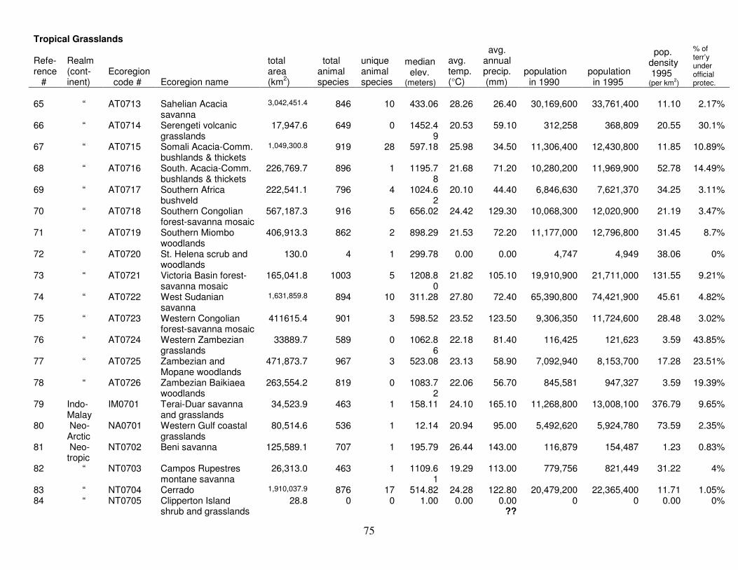
75
Tropical Grasslands
Refe- rence #
Realm (cont-inent)
Ecoregion code # Ecoregion name
total area (km2)
total animal species
unique animal species
median elev. (meters)
avg. temp. (°C)
avg. annual precip. (mm)
population in 1990
population in 1995
pop. density 1995 (per km2)
% of terr’y under official protec.
65 “ AT0713 Sahelian Acacia
savanna 3,042,451.4 846 10 433.06 28.26 26.40 30,169,600 33,761,400 11.10 2.17%
66 “ AT0714 Serengeti volcanic grasslands
17,947.6 649 0 1452.49
20.53 59.10 312,258 368,809 20.55 30.1%
67 “ AT0715 Somali Acacia-Comm. bushlands & thickets
1,049,300.8 919 28 597.18 25.98 34.50 11,306,400 12,430,800 11.85 10.89%
68 “ AT0716 South. Acacia-Comm. bushlands & thickets
226,769.7 896 1 1195.78
21.68 71.20 10,280,200 11,969,900 52.78 14.49%
69 “ AT0717 Southern Africa bushveld
222,541.1 796 4 1024.62
20.10 44.40 6,846,630 7,621,370 34.25 3.11%
70 “ AT0718 Southern Congolian forest-savanna mosaic
567,187.3 916 5 656.02 24.42 129.30 10,068,300 12,020,900 21.19 3.47%
71 “ AT0719 Southern Miombo woodlands
406,913.3 862 2 898.29 21.53 72.20 11,177,000 12,796,800 31.45 8.7%
72 “ AT0720 St. Helena scrub and woodlands
130.0 4 1 299.78 0.00 0.00 4,747 4,949 38.06 0%
73 “ AT0721 Victoria Basin forest-savanna mosaic
165,041.8 1003 5 1208.80
21.82 105.10 19,910,900 21,711,000 131.55 9.21%
74 “ AT0722 West Sudanian savanna
1,631,859.8 894 10 311.28 27.80 72.40 65,390,800 74,421,900 45.61 4.82%
75 “ AT0723 Western Congolian forest-savanna mosaic
411615.4 901 3 598.52 23.52 123.50 9,306,350 11,724,600 28.48 3.02%
76 “ AT0724 Western Zambezian grasslands
33889.7 589 0 1062.86
22.18 81.40 116,425 121,623 3.59 43.85%
77 “ AT0725 Zambezian and Mopane woodlands
471,873.7 967 3 523.08 23.13 58.90 7,092,940 8,153,700 17.28 23.51%
78 “ AT0726 Zambezian Baikiaea woodlands
263,554.2 819 0 1083.72
22.06 56.70 845,581 947,327 3.59 19.39%
79 Indo- Malay
IM0701 Terai-Duar savanna and grasslands
34,523.9 463 1 158.11 24.10 165.10 11,268,800 13,008,100 376.79 9.65%
80 Neo- Arctic
NA0701 Western Gulf coastal grasslands
80,514.6 536 1 12.14 20.94 95.00 5,492,620 5,924,780 73.59 2.35%
81 Neo- tropic
NT0702 Beni savanna 125,589.1 707 1 195.79 26.44 143.00 116,879 154,487 1.23 0.83%
82 “ NT0703 Campos Rupestres montane savanna
26,313.0 463 1 1109.61
19.29 113.00 779,756 821,449 31.22 4%
83 “ NT0704 Cerrado 1,910,037.9 876 17 514.82 24.28 122.80 20,479,200 22,365,400 11.71 1.05% 84 “ NT0705 Clipperton Island
shrub and grasslands 28.8 0 0 1.00 0.00 0.00
?? 0 0 0.00 0%

76
Tropical Grasslands
Refe- rence #
Realm (cont-inent)
Ecoregion code # Ecoregion name
total area (km2)
total animal species
unique animal species
median elev. (meters)
avg. temp. (°C)
avg. annual precip. (mm)
population in 1990
population in 1995
pop. density 1995 (per km2)
% of terr’y under official protec.
85 “ NT0210 Dry Chaco 786,789.5 672 10 315.76 22.19 58.50 3,449,280 3,777,470 4.80 6.88% 86 “ NT0707 Guianan savanna 104,493.8 707 2 353.14 25.63 178.30 168,315 231,712 2.22 32.8% 87 “ NT0708 Humid Chaco 291,590.2 710 5 71.20 22.27 102.80 3,669,860 4,059,640 13.92 4.58% 88 “ NT0709 Llanos 375,786.5 740 8 142.34 27.19 154.90 2,328,610 2,639,750 7.02 6.44% 89 “ NT0710 Uruguayan savanna 352,496.3 531 4 141.80 18.35 115.00 8,454,160 8,845,170 25.09 0.14% 90 Ocea-
nia OC0701 Hawaii tropical high
shrublands 1,847.6 21 0 2663.7
8 16.96 206.90 7,270 8,226 4.45 16.02%
91 “ OC0702 Hawaii tropical low shrublands
1,517.5 59 0 136.29 22.70 62.10 92,779 98,853 65.14 1.13%
92 “ OC0703 Northwestern Hawaii scrub
14.7 47 3 32.56 0.00 0.00 ??
0 0 0.00 97.33%