center for operational oceanographic products and services gps requirements for the national water...
TRANSCRIPT

CENTER for OPERATIONAL OCEANOGRAPHIC PRODUCTS and SERVICES
GPS Requirements for the National Water Level Program
Applications of GPS/GNSS in NOAACross-NOAA Workshop
Boulder, ColoradoOctober 24-25, 2007
Thomas F. LandonNOAA/National Ocean Service
Center for Operational Oceanographic Products and Services

CENTER for OPERATIONAL OCEANOGRAPHIC PRODUCTS and SERVICES
Presentation Overview
• National Water Level Program– National Water Level Observation Network
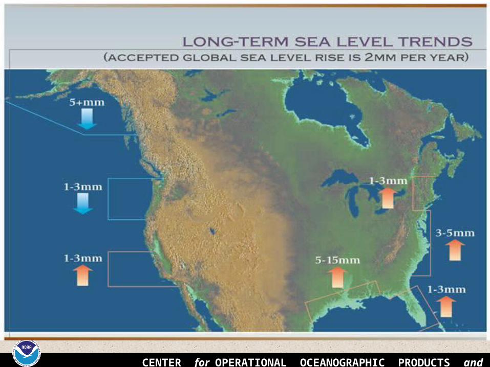
• Leveling at Water Level Stations• Long-Term Sea Level Trends• National Tidal Datum Epoch
– Areas of Anomalous Sea Level Trends• NWLON GPS Operational Plan• Relating the Tidal and Geodetic Datums by
leveling and GPS • GPS Applications

CENTER for OPERATIONAL OCEANOGRAPHIC PRODUCTS and SERVICES
NOAA OCEAN SERVICE NATIONAL WATER LEVEL PROGRAM
• PROVIDES TIDAL DATUM AND WATER LEVEL DATUM
REFERENCES FOR THE ENTIRE U.S COASTAL ZONE
• PROVIDES FOR GEODETIC DATUM CONNECTION AND REFERENCES TO TIDAL DATUMS FOR THE ENTIRE COASTAL ZONE
• PROVIDES FOR UPDATED NATION-WIDE INFORMATION ON RELATIVE SEA LEVEL TRENDS AND LAND MOVEMENT

CENTER for OPERATIONAL OCEANOGRAPHIC PRODUCTS and SERVICES
Remote Pacific Island Stations Not Shown
National Water Level Observation Network
200 Stations as of 2007(planned expansion to 300 stationspending increased base funding)

CENTER for OPERATIONAL OCEANOGRAPHIC PRODUCTS and SERVICES
Milwaukee, Wisconsin (Lake Michigan) Annual Mean Water Levels Relative to LWD
-1
-0.5
0
0.5
1
1.5
18
60
18
70
18
80
18
90
19
00
19
10
19
20
19
30
19
40
19
50
19
60
19
70
19
80
19
90
20
00
Time (years)
Ele
va
tio
n R
ela
tiv
e t
o
LW
D (
me
ters
)
Age of the NWLON Data Series (as of 2002)
0
5
10
15
20
5 20 35 50 65 80 95 110
125
140
155
duration of continuous data (years)
Fre
qu
ency
(nu
mb
er o
f st
atio
ns)
.00%
10.00%
20.00%
30.00%
40.00%
50.00%
60.00%
70.00%
80.00%
90.00%
100.00%
Frequency
Cumulative %
THE NWLON AS A GEOPHYSICAL TIME SERIES

CENTER for OPERATIONAL OCEANOGRAPHIC PRODUCTS and SERVICES
WATER LEVEL STATION CONFIGURATION
• Supporting Structure
• Water Level Sensor(s)
• Data Collection Platform (DCP)
• Bench Mark Network
• Ancillary Sensor(s)

CENTER for OPERATIONAL OCEANOGRAPHIC PRODUCTS and SERVICES
Typical NWLON and Typical NWLON and Short-Term StationsShort-Term Stations

CENTER for OPERATIONAL OCEANOGRAPHIC PRODUCTS and SERVICES
REFERENCING OF THE SENSOR ZERO TO STATION DATUM THROUGH LEVELING AND
BENCH MARKS
Primary Bench Mark and GPS Mark:BG4867 87209840 M TIDAL

CENTER for OPERATIONAL OCEANOGRAPHIC PRODUCTS and SERVICES
Leveling at Water Level Stations
• NGS Accuracy Standards– 2nd Order, Class I for long-term stations– 3rd Order for short-term stations
• Electronic Digital Barcode Leveling Equipment preferred
• Annual leveling for NWLON; installation and removal levels for short-term stations
• Emergency leveling for storm events
CENTER for OPERATIONAL OCEANOGRAPHIC PRODUCTS and SERVICES

CENTER for OPERATIONAL OCEANOGRAPHIC PRODUCTS and SERVICES
A specific 19 year period that includes the longest periodic tidal variations caused by the astronomic tide-producing forces.
Averages out long term seasonal meteorological, hydrologic, and oceanographic fluctuations.
Provides a nationally consistent tidal datum network (bench marks) by accounting for seasonal and apparent environmental trends in sea level that affects the accuracy of tidal datums.
The NWLON provides the data required to maintain the epoch and make primary and secondary determinations of tidal datums.
NATIONAL TIDAL DATUM EPOCH (NTDE)A common time period to which tidal datums are
referenced

CENTER for OPERATIONAL OCEANOGRAPHIC PRODUCTS and SERVICES
IDEALIZED CHANGE OF TIDAL EPOCHACTUAL
1983-01 EPOCH
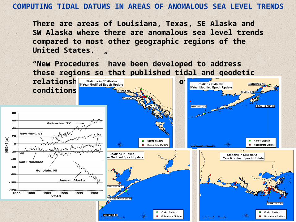
There are areas of Louisiana, Texas, SE Alaska and SW Alaska where there are anomalous sea level trends compared to most other geographic regions of the United States.
“New Procedures” have been developed to address these regions so that published tidal and geodetic relationships are representative of current conditions
COMPUTING TIDAL DATUMS IN AREAS OF ANOMALOUS SEA LEVEL TRENDS

CENTER for OPERATIONAL OCEANOGRAPHIC PRODUCTS and SERVICES
OTHER VERTICAL DATUMS
National Geodetic Vertical Datum of 1929 (NGVD 1929)• Geodetic datum derived from an adjustment of the first orderlevel network of the United States and Canada.• In the adjustment, local mean sea level (MSL) was held fixed at26 tide stations, 21 in the U.S. and 5 in Canada.
North American Vertical Datum of 1988 (NAVD 1988)• Geodetic datum derived from an adjustment of the first orderlevel network of the U.S., Canada, and Mexico.• In the adjustment, local MSL was held fixed at Rimouski,Quebec, Canada.

CENTER for OPERATIONAL OCEANOGRAPHIC PRODUCTS and SERVICES
OTHER VERTICAL DATUMS (Cont.)
International Great Lakes Datum of 1955 (IGLD 1955)• Geodetic datum derived from first order level network alongconnecting channels of the lakes and water level transfers across thevarious lakes.• In the adjustment, local MSL at Fathers Point, Quebec was heldfixed.
International Great Lakes Datum of 1985 (IGLD 1985)• Geodetic datum derived from first order level network throughoutthe Great Lakes in the U.S. and Canada.• In the adjustment, local MSL at Rimouski, Quebec was held fixed.

CENTER for OPERATIONAL OCEANOGRAPHIC PRODUCTS and SERVICES
NWLON GPS Operational Plan
• Requirements: NOS NGS-58, CO-OPS User’s Guide for GPS Observations, CO-OPS Standing Project Instructions, and contractor specifications
• Frequency: coordinated with rate of sea level rise – annually or every five years
• Station GPS mark identified in project instructions• Documentation: all data required for OPUS-DB
submissions• Monitoring: Track and compare solutions over time

CENTER for OPERATIONAL OCEANOGRAPHIC PRODUCTS and SERVICES
GPS Every 5 Yrs
GPS Every 5 Yrs
GPS Annually
GPS Annually atSelected stations, Every 5 Yrs at others
Operational Plan for Periodic GPS ObservationsNational Water Level Observation Network

CENTER for OPERATIONAL OCEANOGRAPHIC PRODUCTS and SERVICES
CORS Co-located with NWLON
• Coordinate with NGS to co-locate CORS sites with long-term NWLON stations
• Level to the CORS GPS reference marks bi-annually as a minimum
• 12 co-located sites in the Great Lakes• NGS performing recons at seven NWLON
sites on the east coast; Key West completed in January 2007
• NGS planning to install CORS at many of the Alaskan NWLON stations

CENTER for OPERATIONAL OCEANOGRAPHIC PRODUCTS and SERVICES
9099004 Point Iroquois, Lake Superior
9087044 Calumet Harbor, Lake Michigan
CORS antenna on houses

NO
AA
Tidal Bench mark4811 G 2004
Station Datum
Orifice
0.7428 m
Tidal Bench mark4811 G 2004
3.150 m
MHW2.736 m
MLLW1.220 m
Bench markwith geodetic control
(NAVD88, WGS84,etc.)
TideGauge
Geodetic Tie to Tidal Datums at Bradmoor Island (Standard Levels Example)
1.150 m(example value)
Pier
Geodetic Benchmark(and its NAVD88 value)Relative to Tidal Datum
Once leveled, you can transform between tidal and geodetic datums.
2.000 m
NAVD88

NO
AA
Tidal Bench mark4811 G 2004
Station Datum
Orifice
0.7428 m
Tidal Bench mark4811 G 2004
3.150 m
MHW2.736 m
MLLW1.220 m
Bench markwith geodetic control
(NAVD88, WGS84,etc.)
TideGauge
Geodetic Tie to Tidal Datums at Bradmoor Island (GPS Example)
1.150 m(example)
Pier
Geodetic Benchmark(and its WGS84 value)Relative to Tidal Datum
GPS Receivers collecting simultaneous data over existing bench marks allow for datum transformation.
2.000 m
GPSReceiver
Ellipsoid
NAVD88

CENTER for OPERATIONAL OCEANOGRAPHIC PRODUCTS and SERVICES

CENTER for OPERATIONAL OCEANOGRAPHIC PRODUCTS and SERVICES
Visual Representation of Visual Representation of Tidal and Geodetic DatumsTidal and Geodetic Datums

CENTER for OPERATIONAL OCEANOGRAPHIC PRODUCTS and SERVICES
Relationship of Tidal Datums to the Ellipsoid

CENTER for OPERATIONAL OCEANOGRAPHIC PRODUCTS and SERVICES
Assessing Sea Level RiseAssessing Sea Level Rise GRAND ISLE, LOUISIANAVARIATIONS IN MONTHLY AND ANNUAL MEAN SEA LEVEL
1.00
1.20
1.40
1.60
1.80
2.00
2.20
2.40
1940 1950 1960 1970 1980 1990 2000 2010
TIME (YEARS)
Ele
vati
on
Rela
tive t
o S
tati
on
Datu
m (
mete
rs)
.
Monthly Mean Sea Level
Annual Mean Sea LevelRelative Mean Sea Level Trend is 9.85 mm/yr

CENTER for OPERATIONAL OCEANOGRAPHIC PRODUCTS and SERVICES
• Using known plant habitat criteria elevations relative to the tidal datum were grouped together for each species.
• Plant specifications– Spartina alterniflora
MLLW – MHW
– Spartina patensMHW-MHHW
Marsh RestorationBarren Island, MD

CENTER for OPERATIONAL OCEANOGRAPHIC PRODUCTS and SERVICES
Measuring Subsidence, Sea Level&
Storm Surge
Measuring Subsidence, Sea Level&
Storm Surge

CENTER for OPERATIONAL OCEANOGRAPHIC PRODUCTS and SERVICES
Questions?