central highlands councilcentralhighlands.tas.gov.au/wp-content/uploads/... · central highlands...
TRANSCRIPT

P a g e | 1
Central Highlands Council
AGENDA – ORDINARY MEETING – 19TH NOVEMBER 2013
Agenda of an Ordinary Meeting of Central Highlands Council scheduled to be held at Hamilton Council Chambers, on Tuesday 19th November 2013, commencing at 9am and be closed to the public until 10.00am.
I certify under S65(2) of the Local Government Act 1993 that the matters to be discussed under this agenda have been, where necessary, the subject of advice from a suitably qualified person and that such advice has been taken into account in providing any general advice to the Council.
Lyn Eyles General Manager
1.0 OPENING
2.0 PRESENT
3.0 APOLOGIES
4.0 PECUNIARY INTEREST DECLARATIONS
In accordance with Regulation 8 of the Local Government (Meeting Procedures) Regulations 2005, the Mayor requests
Councillors to indicate whether they or a close associate have, or are likely to have a pecuniary interest (any pecuniary or
pecuniary detriment) in any item of the Agenda.
5.0 COMMITTEE
Regulation 15 of the Local Government (Meeting Procedures) regulations 2005 provides that Council may consider
certain sensitive matters in Closed Agenda which relate to:
Personnel matters, including complaints against an employee of the Council;
Industrial matters relating to a person;
Contracts for the supply and purchase of goods and services;
The security of property of the Council
Proposals for the Council to acquire land or an interest in the land or for the disposal of land;
Information provided to the Council on the condition it is kept confidential;
Trade secrets of private bodies;
Matters relating to actual or possible litigations taken by or involving the Council or an employee of the Council;
Applications by Councillors for leave of absence;
The personal affairs of any person.

P a g e | 2
The decision to move in Closed Council requires an absolute majority of Council.
5.1 MOTION INTO COMMITTEE
Moved Clr Seconded Clr
THAT Council move into Committee to discuss confidential matters in accordance with Section 15 of the Local
Government (Meeting Procedures) Regulations 2005.
Carried
5.2 MATTERS DISCUSSED IN COMMITTEE
5.3 MOTION OUT OF COMMITTEE
Moved Clr Seconded Clr
THAT Council move out of Committee and resume the Ordinary Meeting.
Carried
OPEN MEETING TO PUBLIC
The Meeting will be opened to the public at 10.00am
6.0 IN ATTENDANCE
Mr Miles Hampton and Mr Mike Brewster from Tas Water will be attending at 10.00 am to address Council on headwork
charges.
Colony 47 will be in attendance at 10.30am
6.1 PUBLIC QUESTION TIME
7.0 MAYORAL COMMITMENTS
15th
October 2013 Plant Committee Meeting Council Meeting – Bothwell 19
th October 2013 Opening – Ouse Craft Fair
21
st October 2013 Bushfire Winter Package Meeting
22
nd October 2013 Inspection & Funding Proposal at SalTas with Minister David O‟Byrne
Combined Planning Authority Meeting (Waddamana – Risdon Vale Line)

P a g e | 3
23rd
October 2013 ABC Interview Leon Compton, Fire Shed New Norfolk on ABC Tower Upgrade & the coming Fire Season Lord Mayor‟s Civic Reception 25
th October 2013 Government House Reception
27
th October 2013 New Norfolk, Gretna, Hamilton, Ellendale, Westerway, Bushy Park, New Norfolk
Bicycle Race. I attended Hamilton stop. 29
th October 2013 Handover from Tas Irrigation to Minister Bryan Green of the Southern Highlands
Irrigation Scheme. Interview with Tas Country and Southern Cross TV Minister David O‟Byrne re funding 14 Mile Road Australia Day Awards (Tasmanian of the Year) announced by Premier Lara Giddings 30
th October 2013 Common Services Model Meeting at Sorell
31
st October 2013 Colony 47, Christmas Packages for the Central Highlnads Area
Central Highlands Community Health Consultative Committee Meeting 1
st November 2013 Australasian Golf Museum Meeting
2
nd November 2013 Open & Welcome – St Vinnies Mannequin Parade, Ellendale
5
th November 2013 Daryl Triffitt Funeral – Ouse
Central Highlnads Tourism Meeting Hon Craig Farrell, New Norfolk Electorate Office 6
th November 2013 Red Cross Christmas Luncheon – Ouse
7
th November 2013 TasWater General Meeting and Annual General Meeting – Riverside
12
th November 2013 Southern Tasmanian Councils Authority Infrastructure Meeting
13
th November 2013 TasWater, Quality Briefing – Moonah
15
th November 2013 Ellendale Family Day
16
th November 2013 Wayatinah Country Club Music Festival
18
th November 2013 Southern Tasmanian Councils Authority Annual General Meeting
7.1 COUNCILLORS COMMITMENTS Clr A J Downie 23th October 2013 Meet Mayor & Clr Allwright
25th October 2013 Rural Alive and Well Luncheon
1st November 2013 Meadowbank SAP Public Consultation
6th November 2013 Red Cross Luncheon
12th November 2013 Planning Committee
Clr G L Herbert 15th October 2013 Council Meeting – Bothwell
P a g e | 4
5th November 2013 Tourism Committee Meeting – Hamilton Clr I V McMichael 21st October 2013 CHCHSCC Finance Meeting Ouse 31st October 2013 CHCHSCC Committee meeting Ouse 1st November 2013 Lake Meadowbank Review Meeting Hamilton. Clr L M Triffitt
15th
October 2013 Council Meeting - Bothwell
2nd
November 2013 Southern Progress Association Meeting
6th November 2013 Red Cross Luncheon
7.2 GENERAL MANAGER COMMITMENTS
15
th October 2013 Plant Committee Meeting
Council Meeting
30 October 2013 Fire Extinguisher training
2 November 2013 Southern Highlands Progress Association Meeting
18 November 2013 STCA Meeting
8.0 NOTIFICATION OF COUNCIL WORKSHOPS
8.1 FUTURE WORKSHOPS
9.0 MAYORAL ANNOUNCEMENTS
10.0 MINUTES
10.1 RECEIVAL DRAFT MINUTES ORDINARY MEETING
Moved Clr Seconded Clr
THAT the Draft Minutes of the Ordinary Meeting of Council held on Tuesday 15th
October 2013 be received.
Carried
P a g e | 5
10.2 CONFIRMATION OF DRAFT MINUTES ORDINARY MEETING
Moved Clr Seconded Clr
THAT the Draft Minutes of the Ordinary Meeting of Council held on Tuesday 15th
October 2013 be confirmed.
Carried
10.3 RECEIVAL DRAFT MINUTES PLANNING COMMITTEE MEETING
Moved Clr Seconded Clr
THAT the Draft Minutes of the Planning Committee Meeting of Council held on Tuesday 12th
November 2013 be
received.
Carried
10.4 RECEIVAL DRAFT MINUTES TOURISM COMMITTEE MEETING
Moved Clr Seconded Clr
THAT the Draft Minutes of the Tourism Committee Meeting of Council held on Tuesday 5th
November 2013 be
received.
Carried
11.0 BUSINESS ARISING
12.0 NRM REPORT
Moved Clr Seconded Clr
THAT the NRM Report be received.
Carried
Derwent Catchment Natural Resource Management Committee Inc.
PO Box 22 Hamilton Tas 7140 Phone: 6286 3211 Fax: 6286 3370
P a g e | 6
Report Central Highlands Council 16th October to 19th November 2013
The DCNRMC executive has had two meetings this month to discuss DCNRMC model, works plan and process to filling
Catchment Coordinator position. NRM South requested that DCNRMC hold on advertising the position until the three
investors get together for the annual review. The MOU meeting review will occur on 14th Nov 2013. Present will be
Jason Branch from Central Highlands Council, Tony Nicholson from Derwent Valley Council, Lyndel Wilson from NRM
South, Jim Allwright & Kathy Van Dullemen from Derwent Catchment NRM Committee. DCNRMC can provide a verbal
update of this meeting at the Central Highlands Council meeting on the 19th of November.
Update on the Commonwealth Grant to develop an Upper Derwent Valley Farmer Producer Group Workshops, Trials and
Field Trips (similar to the Bothwell Farmer Discussion Group).
Derwent Catchment NRM C has contracted Macquarie Franklin to deliver the project requirements. The following
advertisement was placed with The Derwent Valley Gazette & Tasmanian Country (bush telegraph section), advertising
the following.
Do you want to build your skills and knowledge to improve your productivity and sustainability?
Are you a commercial cropping or grazing farmer in the Derwent Valley?
Do you enjoy learning with and from other farmers?
Then this might be the opportunity you’ve been waiting for...
The Derwent Catchment Natural Resource Management (DCNRM) committee is establishing a farmer discussion group
which will be run by Macquarie Franklin. This will involve participating in a series of workshops and field visits to farms
across Tasmania, covering a range of topics and using expert presenters selected by participants.
If you operate a commercial grazing or cropping enterprise in the Derwent Valley and are interested in being involved for
further details and to register your interest please ring Jim Allwright 0448 297 689. Registrations close 11 November
2013.
John Blyth with assistance from Council works crew, have carried out replanting of the Hamilton quarry as per the Quarry
Rehabilitation Plan. This additional work is being undertaken to ensure Council is compliant with its quarry licensing
requirements. Watering of these plantings to ensure their survival during the coming summer is the next part of this
process.
The Fire recovery project is well under way with 5 properties receiving post fire recovery management plans. Farm maps and final review are the remaining requirements of the project.
Weed Works to date include:
DPIPWE has a new Invasive Species Regional Coordinator for the South, her name is Nicole Gill. Nicole has been in contact with DCNRMC on the Orange Hawkweed program in the highlands.
Works have commenced at Blackburn Creek gorse in conjunction with neighboring land owners.
A plan on containment & control of Spanish Heath within the Ellendale has been drafted. This needs to be ground truthed, discussed with Works Supervisor Council and funding opportunities sought after.
The Naturally Inspired Grant for Mt Adelaide has had an extension approved until the 31st December from NRM
South.
A landowner meeting was held at Silver Plains on the 6th Nov 2013. Agenda items for discussion included
continued collaboration of weed control, weed control program details for 2013-14, weed control in the pipeline
P a g e | 7
corridor and understanding Fulton Hogan and Tasmanian Irrigations responsibilities on weed control. A copy of the minutes were sent to Council via General Manager Lyn Eyles
Kathy Van Dullemen
Secretary
Derwent Catchment NRM Committee
13.0 FINANCE REPORT Moved Clr Seconded Clr
THAT the Finance Report be received.
Carried
13.1 ANNUAL REPORT The Draft 2012-2013 Annual Report has been circulated to all Councillors for comment by the Finance Manager. No
comments were received. The Annual General Meeting will be held at Bothwell on Monday, 9 December, 2013
commencing at 8.45 am.
Recommendation:
Moved Clr Seconded Clr
THAT Council adopt the 2012 - 2013 Annual Report.
Carried
14.0 DEVELOPMENT & ENVIRONMENTAL SERVICES
In accordance with Regulation 25(1) of the Local Government (Meeting Procedures) Regulations 2005, the Mayor
advises that the Council intends to act as a Planning Authority under the Land Use Planning and Approvals Act 1993, to
deal with the following items:
Moved Clr Seconded Clr
THAT the Development & Environmental Services Report be received.
Carried
14.1 BIODIVERSITY OVERLAY MAPPING
The Biodiversity Code and mapping was discussed by the Planning Committee at a meeting held on Tuesday 12th
November 2013. A decision was made to make a recommendation to Council to hold a workshop to develop a Biodiversity Overlay Map to be considered by Council.

P a g e | 8
Recommendation Moved Clr Seconded Clr THAT Council proceed to the Workshop Stage for Biodiversity Overlay Mapping with the Workshop to be held on Monday 25
th November 2013 at the Bothwell Council Office commencing at 8.00am.
Carried
14.2 DA 2013/33: PEACOCK DARCEY & ANDERSON P/L : 61 ROTHERWOOD ROAD, LOWER MARSHES :
Subdivision (ONE LOT & BALANCE) in the Rural Zone
Report By: Contract Planner (D Allingham) Approved By: Senior Contract Planner (J Tyson) Applicant: Peacock Darcey and Anderson P/L Owner R G and P L Barr, M P Coleman (Nvs), R L Morgan (Nvs) Discretions Use: „Subdivision‟ Proposal: This report considers an application made to Council for the subdivision of a large rural property at 61 Rotherwood Road, Lower Marshes. The applicant seeks to subdivide the 157ha property (CT 166042-1) within the Rural Zone under the Central Highlands Planning Scheme 1998, into 1 Lot of 23.15ha and Balance (133.85ha). The property is accessed off Rotherwood Road, via Lower Marshes Road from the Midlands Highway. Subdivision is a discretionary use within the Rural Zone. Site Description: The property is located at 61 Rotherwood Road, Lower Marshes, off Lower Marshes Road, approximately 10km from Jericho.
The property, including the proposed Lot 1, has a predominately north-east aspect, with undulating to steep topography - the later mainly confined to bushland in the western and northern part of the property. The property is largely cleared of native vegetation, with the proposed Lot 1 being completed cleared and characterised by improved/native pasture. The western and northern part of the property is characterised by native bushland, forming a contiguous corridor to the west and north. The bushland on the property has been categorised as „Eucalyptus pauciflora forest and woodland not on dolerite‟, and „Eucalyptus pauciflora forest and woodland on dolerite‟ (http://maps.thelist.tas.gov.au).
P a g e | 9
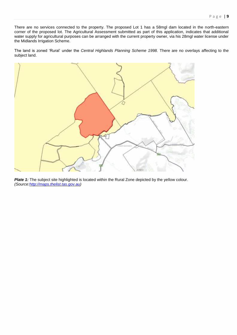
There are no services connected to the property. The proposed Lot 1 has a 58mgl dam located in the north-eastern corner of the proposed lot. The Agricultural Assessment submitted as part of this application, indicates that additional water supply for agricultural purposes can be arranged with the current property owner, via his 28mgl water license under the Midlands Irrigation Scheme.
The land is zoned „Rural‟ under the Central Highlands Planning Scheme 1998. There are no overlays affecting to the
subject land.
Plate 1: The subject site highlighted is located within the Rural Zone depicted by the yellow colour. (Source:http://maps.thelist.tas.gov.au)

P a g e | 10
Plate 2: An aerial image of the subject site depicts the generally cleared nature of the site and surrounds, and the native bushland to the west and south. (Source: http://maps.thelist.tas.gov.au) Statutory Status: The land is zoned Rural under the Central Highlands Planning Scheme 1998. The use category „Subdivision‟ is a Discretionary development type pursuant to Part 1.4 of the Scheme. Section 6 (a) of the Planning Scheme (Development Standards), states that “all new lots shall contain an area of at least 20 hectares”. The proposed Lot 1 is 23.15ha; the balance 133.85ha. The proposed subdivision, therefore, meets the minimum lot size. Permitted uses in the Rural Zone include „feedlot‟, „forestry‟, „house‟, „rural industry‟, „saleyard‟, „utility minor‟ and „visitor accommodation‟. These are all potential uses that could occur on the land, including the proposed new lot. Section 109(1)(d) of the Local Government (Building and Miscellaneous Provisions) Act 1993 provides the requirements for frontage and land area, to ascertain what should constitute a minimum lot within a „country building area‟. The Planning Scheme is silent on a frontage requirement for subdivision occurring within the Rural Zone, Section 109(1)(d)(ii) of the Local Government (Building and Miscellaneous Provisions) Act 1993 applies. This provision provides that a lot must have a minimum 6 metre frontage onto a road. The entire eastern boundary of the proposed Lot 1 adjoins Rotherwood Road. The frontage of the Balance lot is significantly less than that of Lot 1, however, it does have in excess of 11m frontage to Rotherwood Road. Therefore, the proposed subdivision complies with the frontage requirements under the relevant legislation, and does not trigger a referral to the Tasmanian Planning Commission as per Section 109(3)(h). Advertising: The application was subject to a 14 day statutory notification procedure in accordance with section 57 of the Act from the 7
th of October 2013 through to the 21
st of October 2013. No representations were received within the public consultation
timeframe. Council have not delegated authority to consider subdivision applications, therefore this report has been prepared with a recommendation for consideration by full Council.

P a g e | 11
Notification The proposal was not required to be referred to any State Agencies for comments and advice. Adjoining landowners were notified. Planning Evaluation General Objectives: The General Objectives of the Planning Scheme relevant to this proposal are:
(a) To promote the sustainable development of natural and physical resources and the maintenance of ecological processes and genetic diversity.
(b) To provide for the fair, orderly and sustainable use and development of air, land and water;
(e)(iii)To conserve significant vegetation, habitat and scenic resources;
(e)(i) To encourage sustainable long term use of appropriate areas for agricultural, pastoral and forestry activities;
(e)(iv)To encourage land use and development to occur in consideration of land capability
The proposed subdivision is considered to be broadly consistent with the above General Objectives. As noted below in response to the Rural Zone objectives, the proposed subdivision will not significantly alter the underlying agricultural potential of the land, given that it is not considered to be „prime agricultural land‟ (primarily Class 4/5 under the Tasmanian Land Capability Classification System) due to its location, and site characteristics. The proposed Lot 1 also have a water supply that could be used for a small-scale intensive agricultural use. The proposed Lot 1 does not appear to have any significant (e.g. rare or threatened) vegetation type on it. The native bushland, which appears to include a threatened community (see below) is to be retained on the larger balance lot. Rural Zone Objectives: The Objectives of the Rural Zone are reproduced as follows:
a) To encourage and facilitate the development of rural land for sustainable long-term agriculture or pastoral activities, and other uses.
b) To protect rural resources from conversion to other uses.
c) To allow for non-agricultural activities in locations which will not constrain agricultural or pastoral activities or resources.
The Agricultural Assessment report indicates that the property does not contain any „prime agricultural land‟, and the proposed Lot 1 is categorised as Class 4/5 under the Tasmanian Land Capability Classification System. The Assessment indicates that 157ha parent property has been operating as a subsidiary grazing unit over recent years, and that it cannot be operating as a viable, stand-alone agricultural enterprise in its own right (at least in relation to sheep grazing). Subdivision will not significantly change the underlying agricultural potential of the land, being best suited to sheep and/or cattle grazing. However, viability of the smaller proposed Lot 1 may be limited in terms of being a viable grazing unit in its own right. The Agricultural Assessment indicates that the proposed Lot 1 is best suited to “general broad acre agricultural enterprises”, and also mentions the possibility for irrigated Lucerne on the river flats and adjoining land. The Agricultural Assessment indicates that the proposed Lot 1 has a 58mgl dam, providing an annual water resource calculated to be ~16mgl available for irrigation. The potential to arrange access to additional water via the land owner‟s water license further enhances the potential of developing a small-scale intensive operation on the site. The proposal is considered to be consistent with the objectives and development standards of the Rural Zone, by providing for continued agricultural productivity, albeit of limited capacity due to the natural characteristics of the site, as well as the opportunity for other compatible land uses in the future. The proposed subdivision at the very least, maintains the current agricultural capacity of the land. Development Standards

P a g e | 12
Part 1.6 of the Scheme prescribes the development standards relating to subdivision of land. Lot size With regard to lot size, Clause 1.6(a) states that all new lots shall contain an area of at least 20 hectares. As detailed above, the proposed Lot 1 and Balance comply with the minimum lot size. Setbacks The development Standards state that the setback of new buildings used or to be used for habitable purposed must have a setback of 30m to the boundary or a road and 100m to any other boundary. Both the proposed Lot 1 and balance are of a size that could accommodate these required setbacks, in the event that an application for a habitable building was submitted to Council. Schedule 3 – Road Hierarchy, Access and Setback Requirements: Schedule 3 of the Scheme establishes a hierarchy of roads and the access, location and setback requirements in respect to any section of road not restricted to a 60km/h speed limit shall conform to the relevant requirements of this schedule. With regard to site distances, Clause S.3.2 prescribes that:
Access to a road whether subject to a 60km/h speed limit or not, shall have adequate sight distances as set out in Figure 1.
Clause S.3.4 further states that:
The proposed location for a Minor or Major Access shall comply with the sight distance requirements set out in Figure 1 to this Schedule and the access location requirements of S.3.7 and/or S.3.9.
The proposed lots will each utilise existing access points. The proposed Lot 1 is intended to be accessed via the existing access point off Rotherwood Road (illustrated on the Plan of Subdivision), on the south-eastern side of the lot. The Balance lot is intended to be accessed via an existing Right of Way further to the south off Rotherwood Road. This arrangement is illustrated on the plan of subdivision and was approved as a part of a previous subdivision. The proposed access arrangements are satisfactory. Schedule 5 – Matters to be Taken into Consideration in Making Decisions on Applications for a Permit:
Schedule 5 provides additional matters that must be taking into consideration when deciding on any application for a permit and are addressed in the following.
S.5.1 (a) The provisions of any State Policy or interim State Policy Comments in relation to relevant State Policies are discussed below.
S.5.3 – The objectives and other provisions of the Scheme.
These have been addressed previously.
S.5.5 – The effect of the proposed use or development on the landscape, scenic quality or biological diversity of the locality.
Environmental considerations are discussed below.
S.5.7 – The social effect and the economic effect of the proposed use or development in the locality.
The subdivision would have minimal social or economic impacts upon the locality. It could be argued that it has the potential to generate economic return if operated as an agricultural enterprise in addition to continuation of use on the balance lot.

P a g e | 13
S.5.12 – The relation of the proposed use or development to the use or development on adjoining land or on other land in the locality.
The proposed subdivision is unlikely to negatively impact the amenity of adjoining lots and the land uses that are occurring on them. The property is surrounded by large lot sizes primarily zoned Rural, and generally used for agricultural purposes. The proposed subdivision does not change the underlying agricultural potential of the land, for which it is intended to be used for in the future. Therefore, the proposal is considered to be compatible with existing land uses on adjoining lots.
S.5.13 – The provisions of Schedule 3 or any code or policy adopted by Council relating to car parking, and whether the proposed means of access is adequate and whether adequate provision has been made for loading, unloading, manoeuvring and parking of vehicles within the proposed use or development or on that land.
It is considered that standard conditions of approval will adequately address access to the lots.
S.5.15 – The amount of traffic likely to be generated by the proposed use or development, particularly in relation to the capacity of the road system in the locality and the probable effect of that traffic on the movement of traffic and the safety of pedestrians.
Future use of the proposed Lot 1 and balance is likely to be restricted to small-scale agricultural or similar use, and is therefore, unlikely to generate significantly more traffic, beyond the capacity of the road. The types of uses that could result in a significant increase in traffic to the area are discretionary under the Rural Zone, and any applications would have to demonstrate compliance with the planning scheme and associated legislation, including traffic impacts.
S.5.17 – Whether the proposed use or development is likely to cause land degradation.
The proposed subdivision does not change the underlying agricultural potential of the land. As noted below, the native vegetation community is confined to the larger balance lot, and will not be directly impacted on.
S.5.18 – The existing and likely future amenity of the neighbourhood.
As noted above, the proposed subdivision retains large lot sizes, capable of supporting small-scale agricultural enterprises in keeping with the adjoining land uses.
S.5.19 – The effect on the natural, cultural or built heritage.
There are no Aboriginal or historic cultural heritage sites known to occur on the property.
S.5.20 – any objection or submission lodged in respect of an application.
No representations or other submissions have been received in relation to the proposed subdivision. State Policy Implications
State Policy on Water Quality Management Subject to appropriate conditions, the proposal is considered to be able to demonstrate compliance with this Policy with regard to ensuring sediment transport into surface waters does not occur.
State Policy on the Protection of Agricultural Land 2009 The State Policy on the Protection of Agricultural Land protects Prime Agricultural Land (Land Capability Classes 1, 2, and 3) and conversion to non-agricultural uses is subject to the principles of the Policy.
There are seven principles to guide outcomes that give effect to the Policy. Principles 1 to 4 deal with Prime Agricultural Land and are not relevant to this application, given that the Agricultural Assessment classifies the land as Class 4/5. Principles 5 to 7 state:
5. All agricultural land is a valuable resource for Tasmania. The protection of other than prime
agricultural land from conversion to non-agricultural use will be determined through planning schemes.
6. Adjoining non-agricultural use and development should not unreasonably fetter agricultural uses.

P a g e | 14
7. Planning schemes will make provisions for the appropriate protection of the range of non-prime agricultural lands within a specified irrigation scheme.
The proposed subdivision will not change the underlying agricultural potential of the land. The proposal retains the lands viability – albeit naturally limited to small-scale operations, via lot sizes that can continue to support agricultural enterprises similar to those currently undertaken. The availability of water to the proposed Lot 1 for irrigation – being the more fertile area of the parent property, further demonstrates the intent to facilitate productivity capacity. The Agricultural Assessment report notes that even with the limited irrigation water available, there is the potential for more effective land use, and therefore, increased capacity. As indicated above, the proposed subdivision is unlikely to negatively impact on the amenity of adjoining rural lots and the land uses that are occurring on them. Technical Matters Water: No reticulated water services are available to the land. Sewer: No reticulated sewer services are available to the land. Stormwater: No reticulated stormwater serviced are available to the land. Access: Refer to the body of this report for comments relating to access. No other issues or concern have been raised regarding technical matters. Environmental Implications Desktop research indicates that Eucalyptus tenuiramis forest and woodland (http://maps.thelist.tas.gov.au) extends along the north-western boundary of the parent title. This native vegetation type is listed as threatened under Schedule 3A of the Nature Conservation Act 2002.Whilst it is possible that an on-site investigation might reveal that this threatened vegetation type extends into the parent property, it is unlikely to be directly impacted on as a result of the proposed subdivision. The likelihood of potential impact on the balance lot would be considered as part of any future development application. It should be noted that some of the TasVeg data is based on aerial photography and has not necessarily been ground-truthed. CONCLUSION Application has been made for a one lot and balance subdivision at 61 Rotherwood Road, Lower Marshes. The proposed subdivision will create a 23.15ha title adjoining Rotherwood Road, leaving a remainder of 133.85ha lot as the balance. The proposed subdivision complies with the subdivision standards prescribed under the Scheme and is therefore justified on this basis. Further justification is provided in the agricultural assessment prepared by a suitably qualified person submitted as part of the application. The application was advertised and no representations were received. Subject to standard conditions, the application can be approved. Recommendation Moved Clr Seconded Clr That Central Highlands Council (Planning Authority) in accordance with the provisions of the Central Highlands Planning Scheme 1998 and Section 57 of the Land Use Planning & Approvals Act 1993, APPROVE the application for a Subdivision of 1 lot & balance at 61 Rotherwood Road, Lower Marshes, Certificate of Title Volume 166042 Folio 1, subject to the following conditions:
General

P a g e | 15
1. The subdivision layout or development must be carried out substantially in accordance with the application for planning approval, the endorsed drawings and with the conditions of this permit and must not be altered or extended without the further written approval of Council.
Final Plan 2. A fee as determined by Council resolution from time to time must be paid to Council prior to the sealing of each
stage of the final plan of survey. 3. A final plan of survey and two (2) copies must be provided together with the schedule of easements as necessary. 4. All conditions of this permit must be satisfied before the Council seals the final plan. It is the subdivider‟s
responsibility to arrange any required inspections and to advise Council in writing that the conditions of the permit have been satisfied. The final plan of survey will not be dealt with until this advice has been provided.
Easements
5. Easements must be created over all drains, pipelines, wayleaves and services in accordance with the requirements of the Council‟s General Manager. The cost of locating and creating the easements shall be at the subdivider‟s full cost.
Endorsements
6. The final plan of survey must be noted that Council cannot or will not provide a means of drainage, water or sewer services to all lots shown on the plan of survey.
Covenants
7. Covenants or other similar restrictive controls that conflict with any provisions or seek to prohibit any use provided within the planning scheme must not be included or otherwise imposed on the titles to the lots created by this permit, either by transfer, inclusion of such covenants in a Schedule of Easements or registration of any instrument creating such covenants with the Recorder of Titles, unless such covenants or controls are expressly authorised by the terms of this permit or the consent in writing of the Council‟s General Manager.
Bushfire Management
8. An agreement pursuant to Part 5 of the Land Use Planning and Approvals Act 1993 must be entered into prior to the sealing of the final plan of survey to require any residential use or development to be carried out and maintained in accordance with the recommendations of Tasfire (1995), Planning Conditions and Guidelines for Subdivisions in Bushfire Prone Areas, Tasmanian Fire Service, Hobart and constructed in accordance with Level 1 of Standards Australia (1999): AS 3959: Construction of Buildings in Bushfire Prone Areas Standards Australia, Sydney.
Water Quality
9. Temporary run-off, erosion and sediment controls must be installed and maintained at full operational capacity to the satisfaction of Council‟s General Manager until the land is effectively rehabilitated and stabilised after completion of the development.
Property Services
10. Property Services must be contained wholly within each lots served or an easement to the satisfaction of the Council‟s General Manager.
Environmental Health
11. The final plan of survey must be endorsed that the lots are only suitable for the on-site disposal of wastewater using a licensed Aerated Wastewater Treatment System or modified trench septic or other approved system.
Engineering 12. The subdivision must be carried out in accordance with the Central Highlands Council Subdivision Guidelines 2012
(attached).
Existing services
13. The Subdivider must pay the cost of any alterations and/or reinstatement to existing services, Council infrastructure or private property incurred as a result of the proposed subdivision works. Any work required is to be specified or undertaken by the authority concerned.

P a g e | 16
Roadwork’s
14. A vehicle access must be provided from the road carriageway to each lot. Accesses must be located and constructed in accordance with the IPWE Aust. (Tasmania Division) standard drawings and to the satisfaction of Council‟s Municipal Engineer.
Survey pegs
15. Survey pegs are to be stamped with lot numbers and marked for ease of identification. 16. Prior to the works being taken over by Council, evidence must be provided from a registered surveyor that the
subdivision has been re-pegged following completion of substantial subdivision construction work. The cost of the re-peg survey must be included in the value of any security.
Telecommunications, electrical and gas reticulation
17. Where electrical and telecommunications services are to be provided to each lot, they must be provided in accordance with the requirements of the responsible authority and the satisfaction of Council‟s General Manager.
Construction amenity
18. Any works relating to the development must be carried out between the following hours: Monday to Friday 7.00am to 6.00pm Saturday 9.00am to 6.00pm Sundays & Public Holidays 10.00am to 6.00pm
19. All subdivision works associated with the development of the land must be carried out in such a manner so as to
unreasonably cause injury to, or unreasonably prejudice or affect the amenity, function and safety of any adjoining land, and of any person therein or in the vicinity thereof, by reason of –
(a) Emission from activities or equipment related to the use or development, including noise and vibration, which can be detected by a person at the boundary with another property
(b) Transport of materials, goods or commodities to or from the land.
(c) Appearance of any building, works or materials. The applicant shall also be advised that: A. This permit does not imply that any other approval required under any other legislation or by-law has been granted.
B. The issue of this permit does not ensure compliance with the provisions of the Threatened Species Protection Act
1995 or the Environmental Protection and Biodiversity Protection Act 1999 (Commonwealth). The applicant may be liable to complaints in relation to any non-compliance with these Acts and may be required to apply to the Policy and Conservation Assessment Branch of the Department of Primary Industries, Parks, Water and the Environment or the Commonwealth Minister for a permit.
C. This permit shall not take effect and must not be acted on until 15 days after the date of receipt of this
permit unless, as the applicant and the only person with a right of appeal, you notify Council in writing that you propose to commence the use or development before this date, in accordance with Section 53 of the Land Use Planning and Approvals Act 1993.
D. This planning approval shall lapse at the expiration of two (2) years from the date of the commencement of
planning approval if the development for which the approval was given has not been substantially commenced. Where a planning approval for a development has lapsed, an application for renewal of a planning approval for that development shall be treated as a new application.
Carried

P a g e | 17
P a g e | 18
14.3 DA 2013/19 : DIRECTOR OF INLAND FISHERIES & P DOWNIE : 9156 HIGHLAND LAKES ROAD, LIAWENEE :
SUBDIVISION (SIX LOTS & BALANCE) IN THE RURAL ZONE
Report By: Contract Planner (D Allingham) Approved: Senior Contract Planner (J Tyson) Applicant: Director of Inland Fisheries Owner Director of Inland Fisheries Discretions Use: „Subdivision‟ Proposal: This report will consider an application made to the Planning Authority to divide an existing 19.54 ha title at Highland Lakes Road, Liawenee into 6 lots plus balance and adhere the balance to an adjoining lot. The purpose of the subdivision proposal is to make the majority of the land not used by Inland Fisheries Service (IFS) available for the primary purpose of agriculture and for IFS to respond to future operational requirements and effectively manage its assets. The balance lot of 11.4ha would be adhered to the adjacent lot to the south (CT162608/2), and a Memorandum of Understanding (MOU) with the adjoining property owner has been submitted with the application. Lots 1 to 5 would have areas ranging from 5880sqm to 9700sqm, while Lot 6 would be 4.59ha. Lots 1 and 6 would contain existing buildings relating to an existing research station, while lots 2 and 4 would contain existing dwellings. Lots 1, 2, 3 and 6 have direct frontage to Highland Lakes Road. The original application proposed that lots 4 and 5 would be accessed by rights-of-way to Highland Lakes Road over an access strip forming part of Lot 6. However as this arrangement would not provide direct frontage for lots 4 and 5 it will be necessary for the Final Plan to be altered to achieve frontage requirements – this is discussed further below. Site Description: The subject site is owned by Inland Fisheries Service (IFS) and is located on the western side of Great Lake in Liawenee. The property comprises two titles totalling 19.54ha.
The property has the following improvements:
Hostel
Display shed
Workshop
Machinery shed
2 dwellings
Amenities block and laboratory building.
Various outbuildings, ponds and raceways.
The facility is currently used as casual accommodation for IFS field staff, equipment and boat storage and periodic fisheries management purposes. One of the dwellings is occupied by an IFS inspector and the other is leased by Tasmanian Police. The proposed balance of the land is not used for any fisheries management or associated purpose. The Liawenee fish trap and access is located on Hydro land to the north.

P a g e | 19
The bulk of the land is heathland with areas of grassland around buildings created by past clearing and maintenance. All buildings are accessed by gravel roads with a single entry point onto Highland Lakes Road.
In regards to zoning, the subject site and surrounding properties are zoned Rural under the Central Highlands Planning Scheme 1998. The Liawenee Canal and Great Lake are zoned Water Conservation.
Plate 1: The property affected by the subdivision is in red. The adjoining lot to the south will be adhered to the balance. (Source: The List Tas, 2013)
Plate 2: An aerial image of the subject site depicts the nature of the environment. (Source: The List Tas, 2013)
P a g e | 20
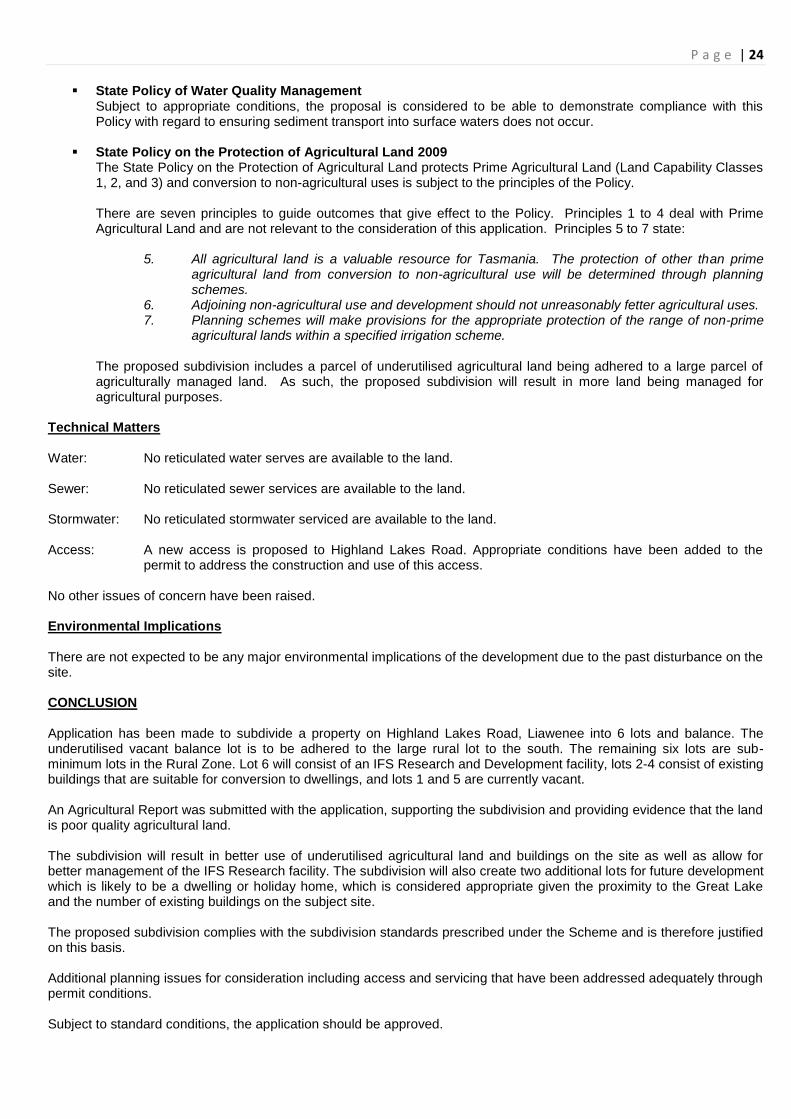
Statutory Status: The land is zoned Rural under the Central Highlands Planning Scheme 1998. The use category „Subdivision‟ is a Discretionary development type pursuant to Part 1.4 of the Scheme. Clause 6 (a) under the Rural Zone in the Central Highlands Planning Scheme 1998 specifies that the minimum lot size in the Rural Zone are 20 ha. However, in special circumstances lots of less than 20 hectares may be approved under Clause 6 (b). As such, all proposed lots, other than the balance, are sub-minimum lots and are Discretionary under the Scheme. Advertising: The application was subject to a 14 day statutory notification procedure in accordance with section 57 of the Act from the 7 October 2013 through to the 21 October 2013. No representations were received within the public consultation timeframe. Notification The application was referred to the Tasmanian Planning Commission (TPC) to approve lots on a subdivision as equivalent to a minimum lot pursuant to section 109(3)(i) of the Local Government (Building and Miscellaneous Provisions) Act 1993. Clause 6 of the Rural Zone in the Scheme does not provide any standard for frontage or access. The lots must therefore satisfy section 109(i) of the Act. Lots 4 and 5 fail to comply with the frontage requirement for a minimum lot specified of this section and therefore may be approved as equivalent to a minimum lot, where:
(i) if, being in any building area and having all the qualities of a minimum lot except in respect of frontage it –
(i) has access to a road by a right of way at least 3·6 metres wide over land not required as the sole or principal means of access to any other land and not required to give the lot, if any, of which it is part the qualities of a minimum lot; and
(ii) is approved by the Commission given at the request of the council, as equivalent to a minimum lot; or…
The TPC wrote to council on 24 September 2013 approving the lots as equivalent to a minimum lot and recommended the following condition to ensure that frontage is achieved:
a. Right-of-way A must be extended to give Lot 5 at least 6m frontage to the right-of-way; and
b. Rights-of-way to lots 4 and 5 must not be reciprocal.
The application was also referred to Department of Infrastructure Energy and Resources (DIER) as it has access to a State Road. DIER responded on 11 October 2013 and has no objection in principle to the proposal. It was advised that any works within the State road reservation will require a permit prior to commencement and to meet DIER specifications and standards. Planning Evaluation General Objectives: The General Objectives of the Planning Scheme relevant to this proposal are:
(a) To promote the sustainable development of natural and physical resources and the maintenance of ecological processes and genetic diversity.
(b) To provide for the fair, orderly and sustainable use and development of air, land and water;
(c) To encourage public involvement in resource management and planning;
(d) To encourage economic development in accordance with the objectives listed above;

P a g e | 21
(e) To give effect to relevant objectives of the Central Plateau, midlands and Southern Midlands Strategic plan and the Central Highlands Council Strategic Plan which are as follows:-
(i) To encourage sustainable long term use of appropriate areas for agricultural, pastoral and forestry activities.
(iv) To encourage land use and development to occur in consideration of land capability;
The application accords with the above general objectives in relation to sustainable land use as the proposal will facilitate the orderly development of the land for long term agricultural activities and better management of existing buildings and the IFS facility. The land is classified as Class 6 and therefore has low agricultural productivity, making subdivision of sub-minimum lots appropriate. The proposal encourages economic development in accordance with the sustainable agricultural objectives above. The proposal is consistent with the General Objectives of the Planning Scheme. Specific Objectives: The Specific Objectives of the Planning Scheme relevant to this proposal are:
a) To encourage diverse uses and to foster the broadening of the economy of the Council area and of the region. The purpose of the proposed 6 lots and balance subdivision is to improve management of existing IFS facilities and to provide better agricultural opportunities on the balance lot. Rural Zone Objectives: The Objectives of the Rural Zone are reproduced as follows:
d) To encourage and facilitate the development of rural land for sustainable long-term agriculture or pastoral activities, and other uses.
e) To protect rural resources from conversion to other uses.
f) To allow for non-agricultural activities in locations which will not constrain agricultural or pastoral activities or resources.
The proposed subdivision will rationalise a lot that is currently being underutilised. The proposed subdivision will allow the balance, which will be adhered to the large rural lot to the south, to be better managed for long-term agriculture activities. The proposal will also allow for better management of the IFS facility and allow for non-agricultural development on the remaining five proposed lots which have very limited agricultural potential. The proposal is considered to be consistent with the objectives and development standards of the Rural Zone. Development Standards Section 6 of the Rural Zone of the Scheme prescribes the development standards relating to subdivision of land that are relevant to this application as follows:
Subdivisions (a) All new lots shall contain an area of 20 ha. (b) In special circumstances, lots of less than 20 hectares may be approved subject to compliance with: (i) The following aims and objectives:
• Prime agricultural land shall be protected from conversion to non-agricultural uses. • Productive agricultural land shall be protected from conversion to non-agricultural uses where it is significant for agriculture and/or for uses related to agriculture.

P a g e | 22
• Prime agricultural land shall only be taken out of agricultural production or out of potential agricultural production where there is an overriding need for the development in terms of public benefit and no other site is suitable for the particular purpose. • Agricultural land shall be managed on a sustainable basis. (ii) Submission of full details of the proposal prepared by a suitably qualified independent agricultural consultant including: • written statement justifying the proposal and giving reasons why compliance with the development standards of the rural zone is unreasonable or unnecessary in the circumstances of the proposal, and/or would tend to hinder the attainment of the above aims and objectives, • a full report identifying the agricultural capacity of the subject land and balance land, and methods to safeguard the agricultural productivity of both.
The proposal seeks to subdivide a 19.54 ha lot into 6 lots and balance and is therefore subject to assessment under Clause 6(b). Lots 1 to 5 range between 5880 sqm to 9700 sqm with lot 6 containing the IFS facility having an area of 4.59ha. The balance of 11.4ha will be adhered to the adjoining 7040 ha lot to the south. An “Agricultural & Environmental Report” prepared by AK Consultants was submitted with the application in accordance with Clause 6(b) (ii) of the Scheme. The Report identifies the land as being Class 6 which is land that “has low productivity, high risk of erosion, low natural fertility or other limitations that severely restrict agricultural use.” According to the report the six proposed lots are already converted due to existing non-agricultural structure on each and the subdivision will have no impact on the agricultural potential of the subject title. Under the existing arrangement no part of the land is being used for agricultural purposes. Under the proposal, the underutilised balance lot will be added to a large rural lot and has potential to be used for grazing or other agricultural activities. Additionally, the proposal will facilitate better management of the IFS facility and allow IFS to sell off assets and provide additional lots for future development. Setbacks
New buildings used, or to be used, for habitable purposes shall be provided with setbacks of:- (i) 30 metres to the boundary of any Road Zone (or greater distance if required by Schedule 3), and (ii) 100 metres to any other boundary.
The existing buildings are located 30m from the Road Zone as required by Schedule 3. However, the existing dwellings and any future dwellings will not be able to meet the 100m setback requirement because of the proposed small lot sizes. As such, any future development will be a Discretionary application. This is considered reasonable give the low agricultural productivity of the land and the number of existing structures on the site. As such, the proposal complies with all the relevant subdivision development standards of the Rural Zone. Schedule 3 – Road Hierarchy, Access and Setback Requirements: Physical access exists to the site via Highland Lakes Road, close to the proposed boundary of lots 1 and 2. Physical access also exists via the adjoining Hydro lot to the north. A new access is proposed to Highland Lakes Road in the south west corner of the site via two Private Right of Ways (ROWs) to lots 4 and 5 which will also give the two lots legal frontage. Creation of an additional ROW over the two private ROWs will provide access to proposed lots 1-3 via the rear. Clause S3.5 of the Scheme requires Council to refer the application to DIER for comments because it proposes a new access to a road in the State Road Network. DIER has advised that any works within the State Road reservation will require a permit prior to commencement and to meet DIER specifications and standards. Any future development must be setback 30m from the Road in accordance with S.3.12

P a g e | 23
Schedule 5 – Matters to be Taken into Consideration in Making Decisions on Applications for a Permit:
Schedule 5 provides additional matters that must be taking into consideration when deciding on any application for a permit and are addressed in the following.
S.5.1 – The provisions of any State Policy or interim State Policy. Comments in relation to relevant State Policies are discussed below.
S.5.3 – The objectives and other provisions of the Scheme.
These have been addressed previously.
S.5.5 – The effect of the proposed use or development on the landscape, scenic quality or biological diversity of the locality.
The proposed subdivision will provide lots for existing structures as well as two new lots that are undeveloped. This will potentially create a small cluster of holiday homes or permanently occupied dwellings. Given the majority of the structures are existing and the area has been largely disturbed, the effect of the subdivision on the landscape, scenic quality and biological diversity will be minimal.
S.5.7 – The social effect and the economic effect of the proposed use or development in the locality.
The purpose of the proposed subdivision is for better management of the unused agricultural land and of the IFS facility and allow IFS to sell off unused buildings as well as create additional lots for development, which will have a positive social and economic effect.
S.5.12 – The relation of the proposed use or development to the use or development on adjoining land or on other land in the locality.
The adjoining land is a large rural lot and the Liawenee canal. There will be no negative impact on these properties.
S.5.13 – The provisions of Schedule 3 or any code or policy adopted by Council relating to car parking, and whether the proposed means of access is adequate and whether adequate provision has been made for loading, unloading, manoeuvring and parking of vehicles within the proposed use or development or on that land.
The proposed new access will require a DIER permit.
S.5.15 – The amount of traffic likely to be generated by the proposed use or development, particularly in relation to the capacity of the road system in the locality and the probable effect of that traffic on the movement of traffic and the safety of pedestrians.
The proposal may generate some additional traffic, which can easily be absorbed by the existing road network.
S.5.17 – Whether the proposed use or development is likely to cause land degradation.
No land degradation is expected to result from this subdivision.
S.5.19 – The effect on the natural, cultural or built heritage. No known Aboriginal or historic cultural heritage sites exist on the property. State Policy Implications
P a g e | 24
State Policy of Water Quality Management Subject to appropriate conditions, the proposal is considered to be able to demonstrate compliance with this Policy with regard to ensuring sediment transport into surface waters does not occur.
State Policy on the Protection of Agricultural Land 2009
The State Policy on the Protection of Agricultural Land protects Prime Agricultural Land (Land Capability Classes 1, 2, and 3) and conversion to non-agricultural uses is subject to the principles of the Policy.
There are seven principles to guide outcomes that give effect to the Policy. Principles 1 to 4 deal with Prime Agricultural Land and are not relevant to the consideration of this application. Principles 5 to 7 state:
5. All agricultural land is a valuable resource for Tasmania. The protection of other than prime
agricultural land from conversion to non-agricultural use will be determined through planning schemes.
6. Adjoining non-agricultural use and development should not unreasonably fetter agricultural uses. 7. Planning schemes will make provisions for the appropriate protection of the range of non-prime
agricultural lands within a specified irrigation scheme.
The proposed subdivision includes a parcel of underutilised agricultural land being adhered to a large parcel of agriculturally managed land. As such, the proposed subdivision will result in more land being managed for agricultural purposes.
Technical Matters Water: No reticulated water serves are available to the land. Sewer: No reticulated sewer services are available to the land. Stormwater: No reticulated stormwater serviced are available to the land. Access: A new access is proposed to Highland Lakes Road. Appropriate conditions have been added to the
permit to address the construction and use of this access. No other issues of concern have been raised. Environmental Implications There are not expected to be any major environmental implications of the development due to the past disturbance on the site. CONCLUSION Application has been made to subdivide a property on Highland Lakes Road, Liawenee into 6 lots and balance. The underutilised vacant balance lot is to be adhered to the large rural lot to the south. The remaining six lots are sub-minimum lots in the Rural Zone. Lot 6 will consist of an IFS Research and Development facility, lots 2-4 consist of existing buildings that are suitable for conversion to dwellings, and lots 1 and 5 are currently vacant. An Agricultural Report was submitted with the application, supporting the subdivision and providing evidence that the land is poor quality agricultural land. The subdivision will result in better use of underutilised agricultural land and buildings on the site as well as allow for better management of the IFS Research facility. The subdivision will also create two additional lots for future development which is likely to be a dwelling or holiday home, which is considered appropriate given the proximity to the Great Lake and the number of existing buildings on the subject site. The proposed subdivision complies with the subdivision standards prescribed under the Scheme and is therefore justified on this basis. Additional planning issues for consideration including access and servicing that have been addressed adequately through permit conditions. Subject to standard conditions, the application should be approved.
P a g e | 25
Recommendation Moved Clr Seconded Clr That Central Highlands Council (Planning Authority) in accordance with the provisions of the Central Highlands Planning Scheme 1998 and Section 57 of the Land Use Planning & Approvals Act 1993, APPROVE the application for a Subdivision (6 lots and balance and boundary adjustment) in the Rural Zone at RA 9156 Highland Lakes Road, Liawenee, Certificate of Title Volume 244852 Folio 1, and Certificate of Title Volume 162608, Folio 2, subject to the following conditions:
General
1. The subdivision layout or development must be carried out substantially in accordance with the application for planning approval, the endorsed drawings and with the conditions of this permit and must not be altered or extended without the further written approval of Council.
2. The subdivision must be carried out in accordance with the Central Highlands Council Subdivision Guidelines.
Amended plan of survey required
3. This permit shall not take effect and must not be acted on until an amended plan of survey have been submitted to and approved by the Council‟s General Manager. This amended plan of survey must show:
Right-of-way A must be extended to give Lot 5 at least 6m frontage to the right-of-way; and
Rights-of-way to lots 4 and 5 must not be reciprocal.
4. Once approved, the amended plan of survey shall become part of the endorsed documents of this permit.
Staged development
5. The subdivision development must not be carried out in stages except in accordance with a staged development plan submitted to and approved by Council‟s Senior Planner.
Transfer of reserves
6. All roads or footways must be shown as “Road” or “Footway” on the final plan of survey and transferred to the Central Highlands Council by Memorandum of Transfer submitted with the final plan.
Final Plan 7. A fee as determined by Council resolution from time to time must be paid to Council prior to the sealing of each
stage of the final plan of survey. 8. A final plan of survey and two (2) copies must be provided together with the schedule of easements as necessary. 9. All conditions of this permit must be satisfied before the Council seals the final plan. It is the subdivider‟s
responsibility to arrange any required inspections and to advise Council in writing that the conditions of the permit have been satisfied. The final plan of survey will not be dealt with until this advice has been provided.
Easements
10. Easements must be created over all drains, pipelines, wayleaves and services in accordance with the requirements of the Council‟s General Manager. The cost of locating and creating the easements shall be at the subdivider‟s full cost.
Endorsements
11. The final plan of survey must be noted that Council cannot or will not provide a means of drainage to all lots shown on the plan of survey.
Covenants
12. Covenants or other similar restrictive controls that conflict with any provisions or seek to prohibit any use provided within the planning scheme must not be included or otherwise imposed on the titles to the lots created by this permit, either by transfer, inclusion of such covenants in a Schedule of Easements or registration of any instrument creating such covenants with the Recorder of Titles, unless such covenants or controls are expressly authorised by the terms of this permit or the consent in writing of the Council‟s General Manager.

P a g e | 26
Bushfire Management
13. An agreement pursuant to Part 5 of the Land Use Planning and Approvals Act 1993 must be entered into prior to the sealing of the final plan of survey to require any residential use or development to be carried out and maintained in accordance with the recommendations of Tasfire (1995), Planning Conditions and Guidelines for Subdivisions in Bushfire Prone Areas, Tasmanian Fire Service, Hobart and constructed in accordance with Level 1 of Standards Australia (1999): AS 3959: Construction of Buildings in Bushfire Prone Areas Standards Australia, Sydney.
Telecommunications, electrical and gas reticulation
14. Where electrical and telecommunications services are to be provided to each lot, they must be provided in accordance with the requirements of the responsible authority and the satisfaction of Council‟s General Manager.
Agreements
15. Agreements made pursuant to Part 5 of the Land Use Planning and Approvals Act 1993 must be prepared by the applicant on a blank instrument form to the satisfaction of the Council and registered with the Recorder of Titles. The subdivider must meet all costs associated with the preparation and registration of the Part 5 Agreement.
Environmental Health
16. The final plan of survey must be endorsed that the lots are only suitable for the on-site disposal of wastewater using a licensed Aerated Wastewater Treatment System or modified trench septic or other approved system.
Department of Infrastructure, Energy and Resources (DIER)
17. No works on or affecting the Highland lakes Road reservation are to be commenced until the Department of Infrastructure, Energy and Resources has issued a permit for same pursuant to Section 16 of the Roads and Jetties Act 1935. Application for the issue of the necessary works permit is to be made to the DIER's Permit Officer (Tel: 6233 7177) at least twenty-eight (28) days prior to the proposed date of commencement of any works.
Engineering 18. The subdivision must be carried out in accordance with the Central Highlands Council Subdivision Guidelines 2012
(attached).
19. Engineering design drawings, to the satisfaction of the Council‟s General Manager or Municipal Engineer, must be submitted to and approved by Council before any works associated with development of the land commence.
20. Engineering design drawings are to be prepared by a qualified and experienced civil engineer, or other person approved by Council‟s General Manager or Municipal Engineer, in accordance with the Central Highlands Council Subdivision Guidelines 2012.
21. Approved engineering design drawings will remain valid for a period of 2 years from the date of approval of the engineering drawings.
22. The developer shall appoint a qualified and experienced Supervising Engineer (or company registered to provide civil engineering consultancy services) who will be required to certify completion of subdivision construction works. The appointed Supervising Engineer shall be the primary contact person on matters concerning the subdivision.
Existing services
23. The Subdivider must pay the cost of any alterations and/or reinstatement to existing services, Council infrastructure or private property incurred as a result of the proposed subdivision works. Any work required is to be specified or undertaken by the authority concerned.
Roadwork’s
24. A vehicle access must be provided from the road carriageway to each lot. Accesses must be located and constructed in accordance with the IPWE Aust. (Tasmania Division) standard drawings and to the satisfaction of Council‟s Municipal Engineer.
25. All driveway carriageways providing shared access to more than one lot must be constructed in accordance with Section 107 of the Local Government (Buildings and Miscellaneous Provisions) Act 1993 and municipal standard drawings. Shared access must include a:
maximum grade of 1 in 5 (20%) onto the lot;

P a g e | 27
minimum trafficable width of 4.00 metres for up to 90 metres, with additional minimum 2.0 metre wide by 20 metre long passing bays at the boundary and every 90 metres along the access otherwise;
all weather pavement;
stormwater drainage, as required.
Survey pegs
26. Survey pegs are to be stamped with lot numbers and marked for ease of identification. 27. Prior to the works being taken over by Council, evidence must be provided from a registered surveyor that the
subdivision has been re-pegged following completion of substantial subdivision construction work. The cost of the re-peg survey must be included in the value of any security.
Defects Liability Period
28. The subdivision must be placed onto a 12 month maintenance and defects liability period following the completion of the works in accordance with the approved engineering plans and permit conditions.
Construction amenity
29. The development must only be carried out between the following hours unless otherwise approved by the Council‟s Manager Strategic Planning
Monday to Friday 7:00 AM to 6:00 PM
Saturday 8:00 AM to 6:00 PM
Sunday and State-wide public holidays 10:00 AM to 6:00 PM
30. All subdivision works associated with the development of the land must be carried out in such a manner so as not
to unreasonably cause injury to, or unreasonably prejudice or affect the amenity, function and safety of any adjoining or adjacent land, and of any person therein or in the vicinity thereof, by reason of -
(a) Emission from activities or equipment related to the use or development, including noise and vibration, which can be detected by a person at the boundary with another property.
(b) Transport of materials, goods or commodities to or from the land. (c) Appearance of any building, works or materials.
31. Any accumulation of vegetation, building debris or other unwanted material must be disposed of by removal from
the site in an approved manner. No burning of such materials on site will be permitted unless approved in writing by the Council‟s General Manager.
32. Public roadways or footpaths must not be used for the storage of any construction materials or wastes, for the
loading/unloading of any vehicle or equipment; or for the carrying out of any work, process or tasks associated with the project during the construction period.
The applicant shall also be advised that: A. This permit does not imply that any other approval required under any other legislation or by-law has been granted.
B. The issue of this permit does not ensure compliance with the provisions of the Threatened Species Protection Act
1995 or the Environmental Protection and Biodiversity Protection Act 1999 (Commonwealth). The applicant may be liable to complaints in relation to any non-compliance with these Acts and may be required to apply to the Policy and Conservation Assessment Branch of the Department of Primary Industries, Parks, Water and the Environment or the Commonwealth Minister for a permit.
C. The issue of this permit does not ensure compliance with the provisions of the Aboriginal Relics Act 1975. If any
aboriginal sites or relics are discovered on the land, stop work and immediately contact the Tasmanian Aboriginal Land Council and Aboriginal Heritage Unit of the Department of Tourism, Arts and the Environment. Further work may not be permitted until a permit is issued in accordance with the Aboriginal Relics Act 1975.
D. This permit shall not take effect and must not be acted on until 15 days after the date of receipt of this permit
unless, as the applicant and the only person with a right of appeal, you notify Council in writing that you propose to commence the use or development before this date, in accordance with Section 53 of the Land Use Planning and Approvals Act 1993.

P a g e | 28
E. This planning approval shall lapse at the expiration of two (2) years from the date of the commencement of planning approval if the development for which the approval was given has not been substantially commenced. Where a planning approval for a development has lapsed, an application for renewal of a planning approval for that development shall be treated as a new application.
Carried
P a g e | 29
14.4 DA 2013/37 : RECREATION FACILITY (BOAT RAMP UPGRADE AND PONTOON) AT BRADYS LAKE :
REMISSION OF FEES
At a meeting of Council held on 19th March 2013 Council discussed proposals by the Inland Fisheries Service for MAST
Recreational Boating Fund Applications and passed the following motion: Moved Clr G L Herbert Seconded Clr A W Bailey THAT Council supports to waive the planning fees for those developments, and to ask for more details regarding costing for in kind support. Further details to be provided to Council.
Carried
For the motion: Mayor D E Flint, Deputy Mayor A J Downie, Clr J R Allwright, Clr A W Bailey, Clr R G Bowden, Clr G L Herbert, Clr T H Jacka, Clr I V McMichael, Clr L M Triffitt Council is now in receipt of an application for a Recreation Facility (Boat Ramp Upgrade and Pontoon) in the Rural Zone and Water Conservation Zone. The fees associated with this application are as follows: Assessment Fee: $160.00 Statutory Advertising Fee: $250.00 In accordance with the motion passed by Council on the 19
th March 2013 it is now recommended that Council remit the
application fees associated with the proposal. Recommendation Moved Clr Seconded Clr THAT Council remit the planning application fee of $410.00 for DA 2013 / 37.
Carried
14.5 DES STATUS REPORT
310 - 17/2/09
Sale of Council Land Wayatinah, responsibility of: DES Manager
A revised plan has been received taking into account Southern Waters requirements. As the lot sizes have now changed
the application will need to be re-advertised. Amended Plan approved by Southern Water. Tenders to be called for
Stage 1 (5 Lots)
323 - 16/11/2010
Caravans – Meadow Bank Lake, responsibility of: DES Manager & Planning Consultant
Council endorsed the public exhibition and consultation process for the draft Lake Meadowbank Planning Project
Background Report on the 17th September 2013 subject to the boundary being amended to include the entire Lake
curtilage.
The plan has been on public exhibition for three (3) weeks and the comments are now being assessed.
331 - 16/7/13
Vehicle body removal in Municipality, responsibility of: DES Manager

P a g e | 30
15.0 COMMUNITY & ECONOMIC DEVELOPMENT REPORT
Moved Clr Seconded Clr
THAT the Community & Economic Development Report be received and noted.
Carried
COMMUNITY & ECONOMIC DEVELOPMENT OFFICER’S REPORT DECEMBER 2013
HIGHLANDS TASMANIA TOURING MAP
A3 versions of the Touring Map printed on a composite material have been distributed to information centres and Central
Highlands businesses for display.
No notification has been received from the Federal Government regarding the Regional Development Australia Fund
allocation of $88,000 to Council for the erection of maps and information bays.
HIGHLANDS TASMANIA – HAMILTON MAP
A public meeting of business owners is being held in the Hamilton Council Chambers, at 2.30pm on Thursday, November
21 to discuss the compilation of the Hamilton map that will be displayed alongside the Highlands Tasmania Touring Map
in the town‟s information bay.
The meeting will also discuss a tourism vision for the town and items to be included in the Highlands Tasmania tourism
brochure.
Meetings on brochure content will be held in other locations.
HIGHLANDS TASMANIA DVD
A rough cut of the musical DVD has been produced but a final version has been delayed by poor weather which has
prevented external filming of Waddamana Power Station and the surrounding area.
Submissions for additional funding have been made to Hydro Tasmania and Tourism Tasmania. A decision on the
amount of funding is pending. Both organisations have indicated they are willing to assist.
Tourism Tasmania has also said it has little film material relating to the Central Highlands and is keen to build its portfolio.
I have asked the film company for access to all footage, pre-editing, and this will be catalogued by Tourism Tasmania so
that even the smallest segment can be accessed in the future.
Destination Southern Tasmania has contributed $960 from post-bushfire advertising funding.
A small group of individual businesses have also been contacted about buying promotional space on the DVD cover.
Some of these businesses have also offered to provide previously filmed material and stills photography for the Council
archive.
The next stage of the project is aerial and other filming around the Central Highlands, subject to weather conditions.
Events footage – Targa, Bothwell Spin In, Hamilton Show, etc. – will be acquired from ABC TV and other sources.
It is proposed to launch the musical DVD before Christmas and the film will be included in the larger Highlands Tasmania
DVD.
HIGHLANDS TASMANIA - GREAT WESTERN TIERS INFORMATION CENTRE
I visited the information centre in Deloraine on Friday, October 19 and met with the manager and the tourism support
officer to explain the brand, using the web site and to discuss their requirements to deliver an effective service and
accurate information about the Central Highlands region.
The meeting was suspended for 45 minutes while staff perused the Central Highlands Council web site and then re-
convened with praise given to the amount of information available.
The team also applauded the touring map and requested tear off maps.
Deloraine information centre is, alongside New Norfolk, the most proactive outlet for the distribution of tourists into the
Central Highlands.

P a g e | 31
It also requested:
Information on food availability and opening times
Information on fuel locations
Information on Bothwell
Up to date information via email
HIGHLANDS TASMANIA – BRIDPORT INNOVATIONS TOURISM INFORMATION CENTRE
I conducted an education session at Bridport on Friday, November 8. The organisation has requested tear off maps and a
large format version of the Highlands Tasmania Touring Map.
The centre is keen to promote golfing, fishing and heritage tourism in the Central Highlands to its audience visiting the
town to play golf at Barnbougle Dunes and Barnbougle Lost Farm.
LAKE ST CLAIR WILDERNESS LODGE CONTACT REPORT
I met Helen Dillon, lessee and developer of Lake St Clair Wilderness Lodge, on Saturday, October 26, to explain the
Highlands Tasmania Brand and the venue‟s critical role in supporting the brand strategy.
The re-development of Lake St Clair Wilderness Lodge has had its problems and significant issues over the last 18
months that have raised concern within Tourism Tasmania, Parks and Wildlife, the Tourism Industry Council Tasmania
and Destination Southern Tasmania.
For Central Highlands Council, the issues have related specifically to the conduct of the re-development, compliance and
food safety controls.
The property has been granted occupancy certificates, but completion has been delayed by the absence of assurances
from contractors that the work has been undertaken to the required standards.
A final inspection is expected soon.
Council has been briefed on plans to alter the restaurant to rid it of its cafeteria-style and the business has appointed an
executive chef to present a more extensive, Tasmanian-focussed menu once the work is completed.
Ms Dillon is adamant that once the development phase is concluded the entire focus of the business will be on a high
level of service delivery to guests and the continuation of marketing in international markets, especially in Asia and
particularly China.
All staff, with the exception of one, are multi-lingual, speaking between three and seven languages.
The company has already commissioned the design of a new purpose-built ferry, with higher passenger capacity, to
operate on Lake St Clair. Ferry schedules maybe increased in the coming season.
It is planning to stage a Tasmanian beverage event in 2014.
HIGHLANDS TASMANIA TURNING OF THE FAGUS FESTIVAL
Mt Field Tourism Group has indicated it is willing to co-operate with Highlands Tasmania and the Botanical Gardens to
promote a Turning of the Fagus Festival in April and May next year.
HIGHLANDS TASMANIA FOOD TRAIL
The diversity of food and beverage in the Central Highlands has been highlighted in the latest issue of Central Highlands
News and I hope to develop the concept of a food trail within the region.
There is a wide variety and individuality of snacks and meals on offer.
I am also encouraging food businesses to package products for sale to tourists. Several places are looking at this option
and some have already begun sales.
In the case of larger venues, it means staff can be profitably occupied in slow periods and downtime between lunch and
evening sessions.

P a g e | 32
HEALTHY COMMUNITIES INITIATIVE

P a g e | 33
WAYATINAH SCHOOL BUILDING DEVELOPMENT
I met Wayatinah resident Mr Shayne Knowles on Tuesday, November 5, to discuss his proposal to develop the former
Wayatinah School into a tourism information centre and antiques shop.
The building has been used as a storage unit by another Wayatinah resident for a number of years and requires internal
and external refurbishment.
I have asked DES manager Graham Rogers to inspect the building‟s suitability for the purpose proposed. I have been
advised, should the project go ahead, that it will require development approval.
Mr Knowles is prepared to renovate the interior and, with the aid of the Wayatinah Sports & Social Club, to make repairs
and alterations to the entrance ramp to comply with disabled access requirements.
The combination of tourism information centre and commercial business is a model that works well at the Australasian
Golf Museum, in Bothwell.
Currently there are only two formal information centres in the Central Highlands, Bothwell and the Parks and Wildllife
Centre, at Lake St Clair. The next two nearest information centres are at New Norfolk and Queenstown.
Mr Knowles has also proposed the information centre becomes an outlet for food and beverage producers and other
small businesses in the Central Highlands, as previously suggested for the former Elders building, in Bothwell.
He believes his antiques business will provide an off-highway attraction for tourists. His initiative is supported by the
owners of the Wayatinah Tavern and Store who are keen to expand their own business and increase opening hours.
The local community is also exploring the possibility of establishing some short walks around Lake Wayatinah and into an
area of forest that is believed to rival The Styx in terms of the age and size of its trees.
RECOMMENDATION: That Council approves, in principal, the proposal to convert the former Wayatinah School into an
information centre and retail outlet, subject to development application for a change of use and that subsequently a
leasing arrangement will be negotiated between Council and Mr Knowles.
PARTNERSHIPS IN COMMUNITY AND BUSINESS CONFERENCE, NOVEMBER 6 & 7, 2013
I attended this conference with more than 200 people from the business, government and non-Government and not-for-
profit sectors.
Primarily, the conference explored partnerships between business and the community in developing mutually beneficial
social enterprise projects, funded by the private sector, rather than State Government.
Delegates heard a number of case studies of successful liaisons and workshopped potential ideas, culminating in the
presentation of structured strategic projects.
I presented on the creation of a not-for-profit marketing group for small food and beverage producers, partnering with an
international airline to bring potential Asian distributors to Tasmania. It also explored the creation of a packaging buying
group for food and beverage businesses, who are currently at a significant disadvantage because of the volume
purchases demanded by the duopoly of suppliers in Tasmania.
Since the conference, I have been in contact with a Chinese glass manufacturer who would consider supplying smaller
quantities in mixed consignments into Tasmania. If this progresses positively, a retail, wholesale and distribution
operation could be established in Bothwell.

P a g e | 34
COMMUNITY GRANT APPLICATION
A community grant application for $500 towards power charges has been received from Ouse Online Centre.
RECOMMENDATION: Approval
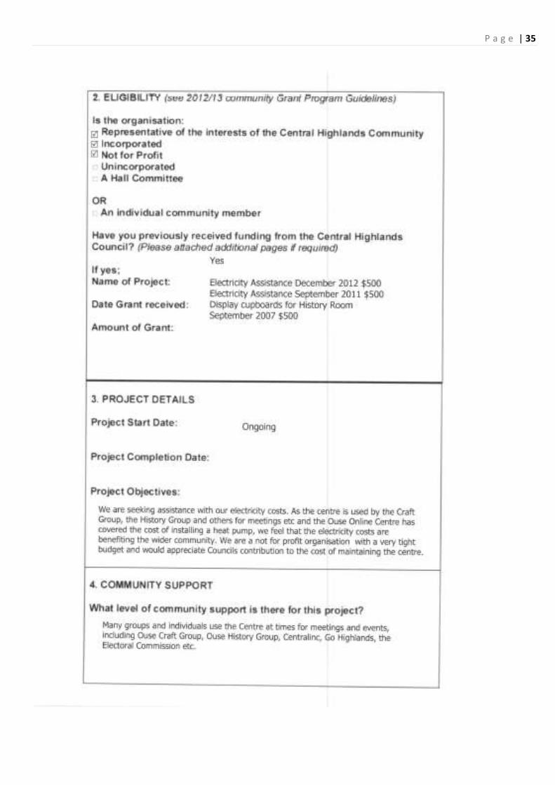
P a g e | 35
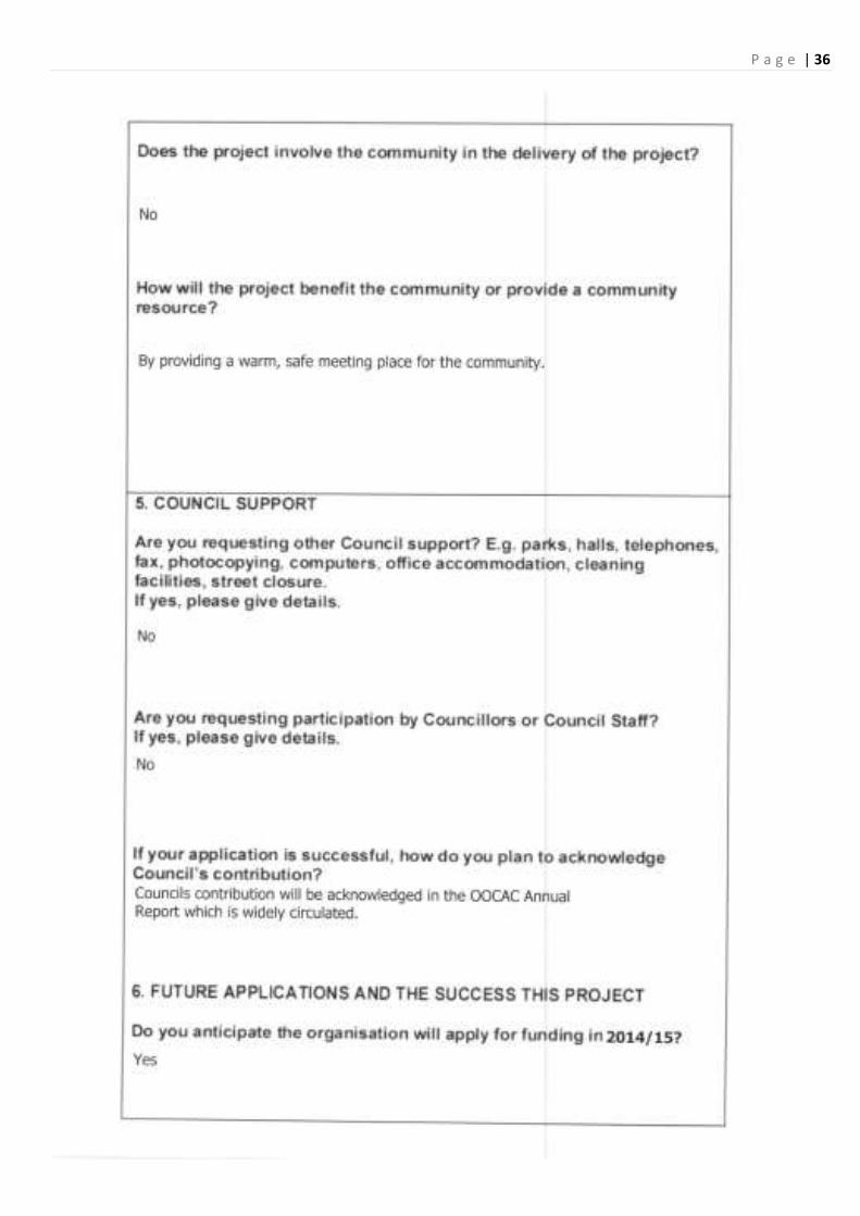
P a g e | 36

P a g e | 37
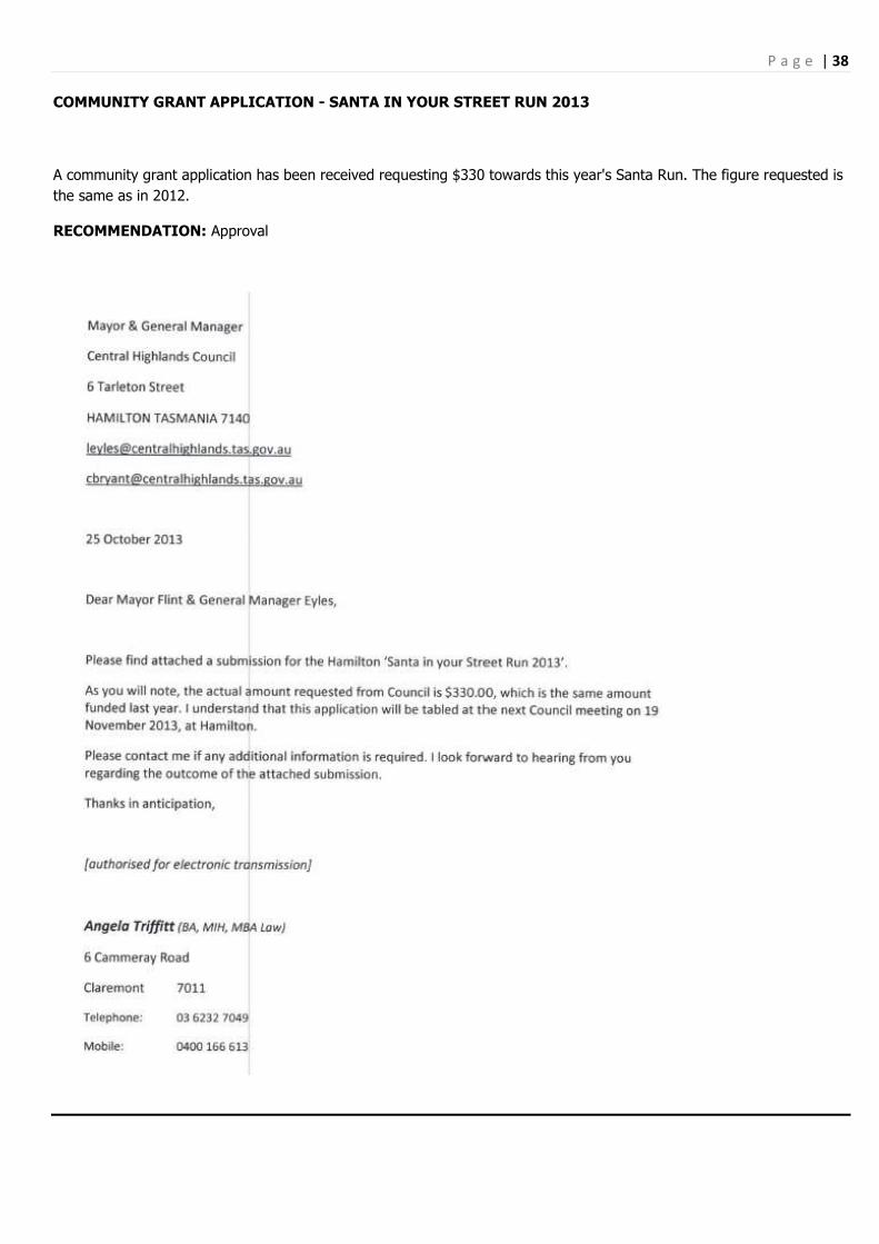
P a g e | 38
COMMUNITY GRANT APPLICATION - SANTA IN YOUR STREET RUN 2013
A community grant application has been received requesting $330 towards this year's Santa Run. The figure requested is
the same as in 2012.
RECOMMENDATION: Approval

P a g e | 39

P a g e | 40

P a g e | 41
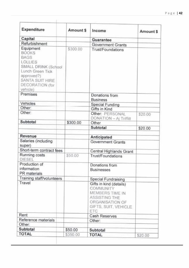
P a g e | 42

P a g e | 43
COMMUNITY GRANT APPLICATION – GREAT LAKE ANNUAL CHRISTMAS PARTY 2013
A community grant application has been received requesting $200 towards this year's Great Lake Annual Christmas Party.

P a g e | 44

P a g e | 45

P a g e | 46

P a g e | 47
16.0 WORKS & SERVICES
Moved Clr Seconded Clr
THAT the Works & Services Report be received.
Carried
WORKS & SERVICES REPORT
12th October – 12th November 2013
Grading & sheeting
Fourteen Mile Road
Maintenance Grading
Trout Crescent Little Pine Lagoon road
Johnsons‟ Rd / Fleming Drive Lochiel Drive
Cider Gum Drive Tip Road Great Lake
Fourteen Mile Road Anglers Crescent
Robertsons Rd
Potholing / Shouldering
Fourteen Mile Road Arthurs Lake Road
Strickland Road Ellendale Road
Victoria Valley Road
Culverts / Drainage
Ellendale Road Arthurs Lake Rd
Lanes Tier Road Rockmount Road
Tor Hill Road Dry Poles Road
Rayner‟s Hill Road
Occupational Health and Safety
Fire Training Course for all Employees
Weed Inspector Training – Barry Harback
Refuse / recycling sites:
Cover Hamilton Tip twice weekly
Municipal Town Maintenance:
Collection of town rubbish twice weekly
Maintenance of parks, cemetery, recreation ground and Caravan Park.
Cleaning of public toilets, gutters, drains and footpaths.
Collection of rubbish twice weekly
Cleaning of toilets and public facilities
General maintenance
Mowing of towns and parks
Town Drainage

P a g e | 48
Weed control:
Hollow Tree Road - Roadside Spraying Ellendale Road
Gretna Town Spraying Hamilton Rec Ground
Ellendale Town Spraying
Plant: (Repairs and Maintenance)
PM741 – Mack Hamilton, Repairs to tray and tow hitch
Private Works:
Paul Benbow Gravel Delivers Tas Water
Allan Smith Gravel Delivers Gravel Ian McMichael
Michael Bailey Mowing Annie Devoy Gravel
Andrew Jones pick up gravel Patsy Bryant Mowing
Justin Townsend dry hire mower Mary Bye Mowing
Darrell Horne dry hire mower Anthony Archer Backhoe Hire
Helen Monks Gravel Nant Distillery premix
Terry Hoskinson cement mix Downer EDI Australia Grading Marlbourgh Highway
W.J.Gunn Gravel
Casuals
Toilets, rubbish and Hobart
Bothwell general duties
Hamilton general duties
Mowing and brush cutting
Program for next 4 weeks:
Drainage Ellendale Road
Pot holing roads around Municipality
Mowing in all towns
Stabilization of Ellendale Rd
Jet-patching of Municipal Roads
16.1 Pelham Diversion Final Plans
Plans can be viewed by contact Casey or Jason
16.2 Old Arthurs Lake Road
For Discussion

P a g e | 49

P a g e | 50

P a g e | 51

P a g e | 52
16.3 Fuel Tank at Bothwell Depot
From: Gilbert Hills [mailto:[email protected]]
Sent: Friday, 8 November 2013 12:03 PM
To: Jason Branch
Subject: 2200LITRE OVERHEAD FUEL TANK
TAS PETROLEUM WOULD LIKE TO SUBMIT AN OFFER OF $ 400 FOR YOUR 2200 LITRE FUEL TANK LOCATED IN
THE CENTRAL HIGHLAND COUNCIL YARD AT BOTHWELL
CHEERS
Gilbert Hills Tas Petroleum
Recommendation: Moved Clr Seconded Clr THAT Council sell the 2200 litre fuel tank located at Bothwell to Tas Petroleum for $400
Carried
16.4 STATUS REPORT
328 - 20/4/2012
Gorse at Christian Marsh, Responsible Officer: NRM This item was asked to be placed on the Status Report at the March 2012 Meeting.
329 - 18/8/2012
Platypus Walk, Responsible Officer: Works Manager
Regular Maintenance
332 - 17/9/2013
Blackberry Removal, Responsible Officer: Works Manager / NRM Clr Bowden requested that this item be placed on the Status Report
17.0 ADMINISTRATION
17.1 REVIEW OF COUNCILLOR NUMBERS 2013 (SEPARATE ATTACHMENT)
The Hon Bryan Green MP has forwarded a report and recommendations on the second review of Councillor Numbers.
Councils which were included in the review were Derwent Valley, Southern Midlands, Waratah-Wynyard, Brighton,
Launceston and Dorset.
The Minister is inviting Councils to make submissions on the report which should be received by 5 December, 2013.
For Noting / Discussion

P a g e | 53
17.2 REVIEW OF COUNCIL POLICIES (SEPARATE ATTACHMENT)
As part of the continuing review of Council policies, the following policies have been reviewed and are submitted to
Council for adoption:
2013-05 Use of Council Vehicles Policy
2013-14 Manual Handling Policy
2013-15 Occupational Exposure to Blood & Body Fluids Policy
2013-16 Drug & Alcohol Policy
2013-17 Use of Council Sporting Facilities Policy
2013-18 Employee Recruitment & Selection Policy
RECOMMENDATION
Moved Clr Seconded Clr
THAT Council Adopt Policy No. 2013-05 and Policy Numbers 2013-14 to 2013-18.
Carried
17.3 DRAFT MINISTERIAL ORDERS (SEPARATE ATTACHMENT)
The Local Government (Miscellaneous Amendments) Bill 2013 (the Bill) was passed on 30 October, 2013. The Bill
included a power for the Minister to make Ministerial Orders outlining the detail and minimum requirements of the
financial and asset management reforms and the use of Audit Committees detailed in the amending legislation.
The Local Government Division is seeking comments/feedback by 20 December, 2013 and LGAT would like to prepare a
consolidated submission. LGAT seeks comments by Monday 16 December, 2013.
Also included is a copy of letter sent to LGAT from the Director of Local Government addressing comments made by
LGAT.
For Discussion
18.0 SUPPLEMENTARY AGENDA ITEMS
Moved Clr Seconded Clr THAT Council consider the matters on the Supplementary Agenda.
Carried
19.0 COMMITTEE REPORTS
20.0 CLOSURE