central weather bureau - msroc.org.t. share (m3/person/year) twn average jpn chn ......
TRANSCRIPT

Central Weather Bureau
Missions and Operations
Shin, Tzay-Chyn
Director General, Central Weather Bureau

Background
CWB Missions
R2O projects to support CWB Operations
The way forward

TEMBIN
Geographical environment of Taiwan
BOLAVEN
2012.Aug. Location
continent/ocean boundary
tropical/sub-tropical
Topography
over 1km ~ 32%
peak ~ 3950m
Size
small 350km x 150km
Population 23M
large density /vulnerable
small amount/ limited MP

Rainfall vary with season and location

Rainfall vary with season and location

Rainfall rate
Northern Taiwan Central and southern Taiwan Eastern Taiwan
Contributed from short period, small scale, intensive events

水利署(WRA)::「台灣地區水資源運用現況與未來發展問題」From Water Resources Agency, R.O.C.
Limited water resources
USA
Precip. share
(m3/person/year)
TWN
Average
JPN
CHN
Avg annual Precp.

CWB cares about
http://t17.techbang.com
http://keepsurfing.pixnet.net
http://www.tia.org.tw
http://chinataiwan.org
Spring rain
(Feb-Mar)
Meiyu heavy rain (May-Jun)
Heat
wave
(Jul-Sep)
Typhoon
(Jul-Sep)
Cold surge
(Dec-Feb)
Drought
(Apr--)

CWB MISSIONs
Enhance the science-based observation and forecast capabilities for
delivering accurate and timely service information to all sectors
Promote weather awareness and knowledge as well as encourage
cross-sectoral dialogues for all possible value added usages &
applications
Provide science based meteorological service information to government and
society for safer and better life

To Fulfill the Missions
Modernized Refined BroadenedObservations Forecasts Services++
Partnership is the key to the success of the missions

NSF, NASA, NCAR, Univ.
NOAA RESEARCH PROGRAMS, DTC
OAR/NSSL, ESRL/GSD
NWS/MDL, NCEP, NWSUSA
BASIC
RESEARCH
APPLIED
RESEARCH
TRANSITION TO
OPERATIONS
NMHS
OPERATIONS
Answer
Science
Questions
Develop
MethodsPrepare for
ImplementationGenerate
Products
External /
University
Investigators
Government
Research
Laboratories
NMHS
R&D Centers
NMHS
Central
Operations
PHASE
What?
Who?
Adopted from http://www.emc.ncep.noaa.gov/gmb/ens/ScienceMtg_04-27-06.html
Partnership for Research to Operation
END USER
APPLICATIONS
Effective
Use of
Products
Venders
Communities
Government AGs
Value added
businesses
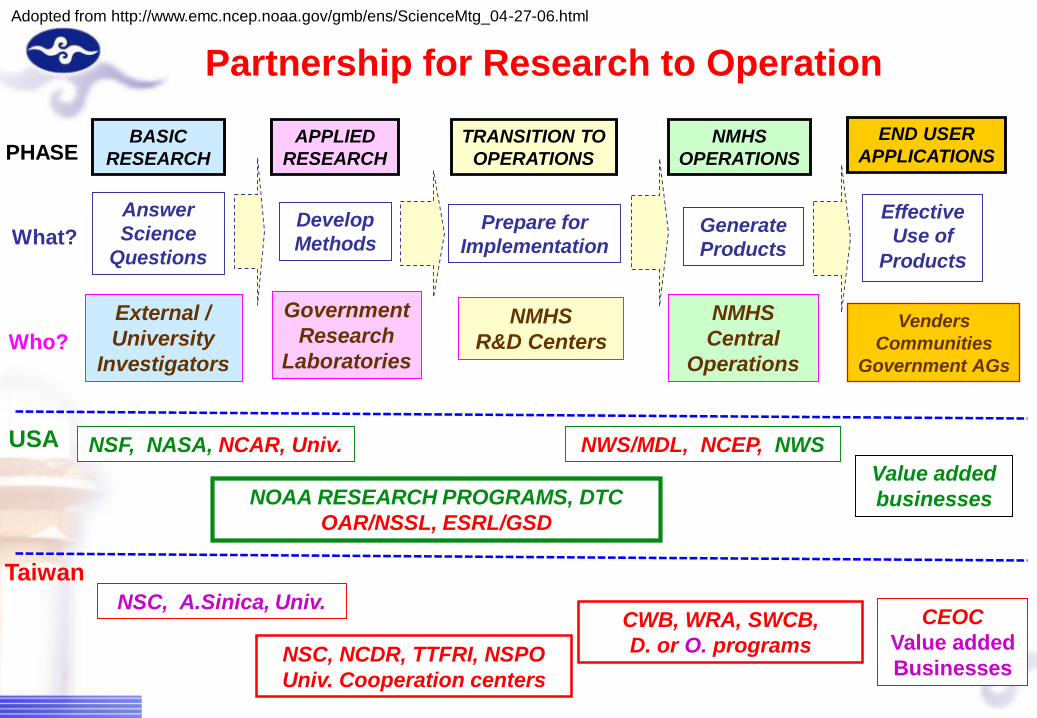
NSF, NASA, NCAR, Univ.
NOAA RESEARCH PROGRAMS, DTC
OAR/NSSL, ESRL/GSD
NWS/MDL, NCEP, NWSUSA
BASIC
RESEARCH
APPLIED
RESEARCH
TRANSITION TO
OPERATIONS
NMHS
OPERATIONS
Answer
Science
Questions
Develop
MethodsPrepare for
ImplementationGenerate
Products
External /
University
Investigators
Government
Research
Laboratories
NMHS
R&D Centers
NMHS
Central
Operations
PHASE
What?
Who?
Adopted from http://www.emc.ncep.noaa.gov/gmb/ens/ScienceMtg_04-27-06.html
Partnership for Research to Operation
Taiwan
NSC, A.Sinica, Univ.
NSC, NCDR, TTFRI, NSPO
Univ. Cooperation centers
CWB, WRA, SWCB,
D. or O. programs
CEOC
Value added
Businesses
END USER
APPLICATIONS
Effective
Use of
Products
Venders
Communities
Government AGs
Value added
businesses

Targeted Observations
(NTU,TTFRI)
DOTSTAR missions
2003~2013 :
54Typhoons,
69 missions, 373 Hours, 1146 Drops.
Dropsonde
Flight domain

National
Cheng Kung
university
•Data buoy maintain and
information management
operations
•Tide gauge data QC
National
Taiwan
Ocean
University
Develop AIS
( Automatic
Identification System)
marine meteorology
information broadcast
system
Marine Meteorology
Observations

2014/6/10 16
GPSRO – NCAR,JCSDA(NCEP)
NSPO,TTFRI ,Univ.
FS3(2005)/COSMIC
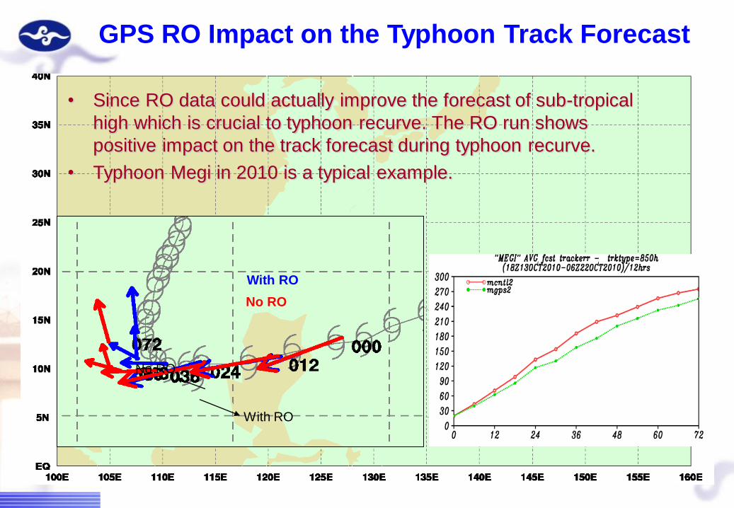
• Since RO data could actually improve the forecast of sub-tropical
high which is crucial to typhoon recurve. The RO run shows
positive impact on the track forecast during typhoon recurve.
• Typhoon Megi in 2010 is a typical example.
GPS RO Impact on the Typhoon Track Forecast
With RO
No RO
With RO
No RO

Radar
Satellite
Sfc Obs &
Sounding
Lightning
LAPS
Single
Radar
Process
Rain Gauge
Hydro
Model*
QPESUMS - OAR/NSSL
Precip
Products
Hydro
Products
Users
QPF2D/3D
Radar
Mosaic
Mosaic
Products
Verification
Warning
Decision
Products
QPE
RCWF
RCKT
RCHL
RCCG
RCCK
RCMK
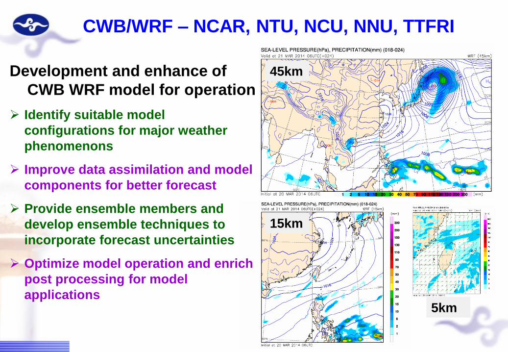
CWB/WRF – NCAR, NTU, NCU, NNU, TTFRI
Development and enhance of
CWB WRF model for operation
Identify suitable model
configurations for major weather
phenomenons
Improve data assimilation and model
components for better forecast
Provide ensemble members and
develop ensemble techniques to
incorporate forecast uncertainties
Optimize model operation and enrich
post processing for model
applications
45km
15km
5km
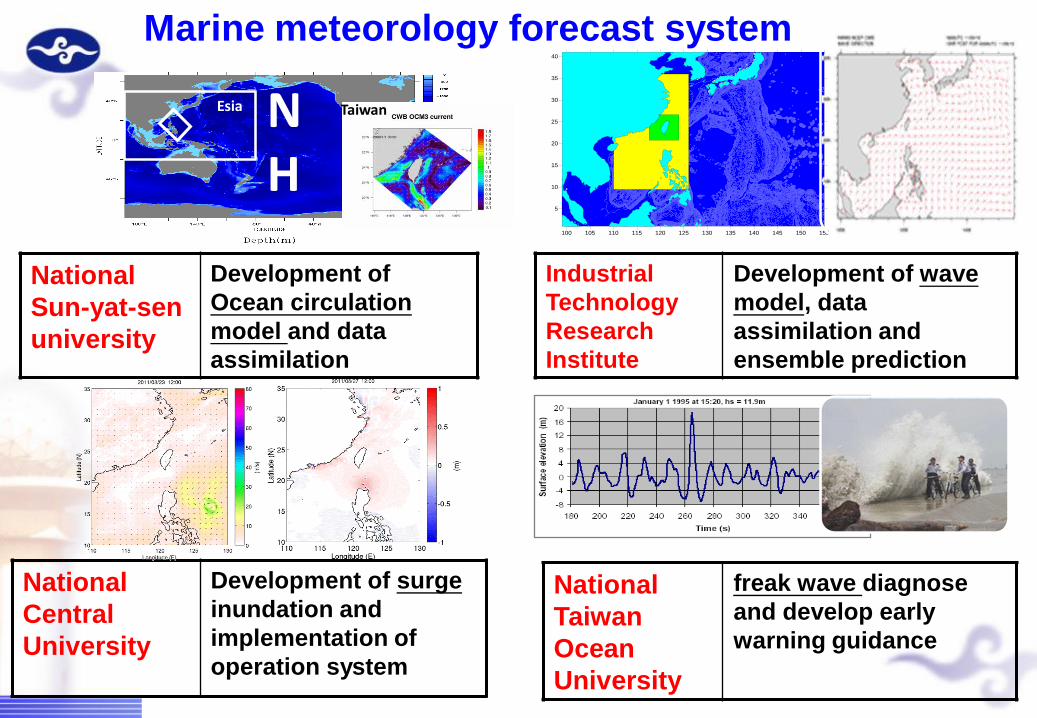
National
Sun-yat-sen
university
Development of
Ocean circulation
model and data
assimilation
100 105 110 115 120 125 130 135 140 145 150 155
5
10
15
20
25
30
35
40
Industrial
Technology
Research
Institute
Development of wave
model, data
assimilation and
ensemble prediction
National
Taiwan
Ocean
University
freak wave diagnose
and develop early
warning guidance
NH
Esia
National
Central
University
Development of surge
inundation and
implementation of
operation system
Taiwan
Marine meteorology forecast system

HWRF – NWS/NCEP/EMC, DTC, TTFRI
Adopt and test HWRF for
Taiwan area
Training and workshop
Test Performance of
HWRF in Taiwan
Uses HWRF as ensemble
members
HWRF-T Fixed domain focus the
TC heavy rainfall forecast on
Taiwan

Develop of Intra-seasonal to Inter-annual climate
monitoring and forecast techniques
- NWS/NCEP/CPC, EMC
Create CWB/TC track potential
(16days) using NCEP/GFS and
rovide for CPC Tropical Hazards
outlook
Provide CWB/GFS 45 days model
output for MJO forecast experiment
Provide CWB precipitation obs. for
CPC global rainfall monitoring
Attend the CPC Monsoon Desk
training program
Participate the Climate Diagnostics
and Prediction Workshop
2th CWB next generation Global
Forecast System planning workshop
(May 7~9, 2014)
Dynamical
Model MJO
Forecasts

1987
CDC
Cyber 205
Comp pwr as
1/3704 current
1994
CRAY
YMP-8i
Comp pwr as
1/303 current
2000
FUJITSU
VPP5000
Comp pwr as
1/15 current
2006
IBM
P5-575
Comp pwr as
x1
1984-89
Phase 1
19 90-94
Phase 2
1995- 2001
Phase 3
20 02-09
Phase 4Top500/氣象排名No293/No18
Top500/氣象排名No91/No14
Top500/氣象排名No45/No5
●●
●●
2006
GFS : 40KM
RFS : 20/4KM; 45/15/5KM
EFS : 40 mbrs/day
1994
GFS : 165KM
RFS : 65/20KM
2000
GFS : 110KM
RFS : 45/15/5KM1987
GFS : 275KM
RFS : 90KM
CWB NWP improved as HPC power increased

Background based on the slide from
NWS Director Dr. Louis W. Uccellini
Wave Forecast
NWW3, SWAN,Tide
Typhoon Forecast
TWRF
12-72 Hours Forecast
NFS, WRF
7-30 days Forecast
GFS
GFS-ensemble
1-6 months Forecast
CFS-ensemble Climate/Weather
CWB
CWB
0-12 Hours Forecast
LAPS, ARPS, QPESUMS, ANC
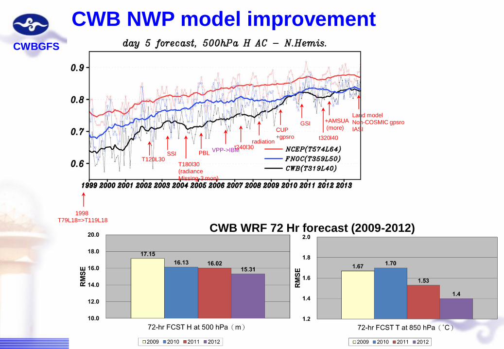
CWB NWP model improvementCWBGFS
CWB WRF 72 Hr forecast (2009-2012)
+AMSUA
(more)
t320l40
GSICUP
+gpsroradiation
t240l30VPP->IBM
PBL
T180l30
(radiance
Missing-3 mon)
SSIT120L30
1998
T79L18=>T119L18
Land model
Non-COSMIC gpsro
IASI

16
93
152
203
268
333
411
7 66
104
152
215
289
366
8
67
102
134 168
215
285
148
120
248
193
93688
243
369
130
286
173
92
0
50
100
150
200
250
300
350
400
450
0 12 24 36 48 60 72
forecast hours (hr)
trac
k er
rors
(km
)
CV3_OL_DFI_GD
CV5_OL_DFI_GD
CV5_OL_DFI_KF
CV5_OL_DFI_KF_Par
WRF_OP
CWB
2012 TWRF
improvement
(247 cases)
Official TC
forecast track
error from
1994 to 2010
official forecast

Morakot 2009
Megi 2010
Challenge

1987
CDC
Cyber 205
Comp pwr as
1/3704 current
1994
CRAY
YMP-8i
Comp pwr as
1/303 current
2000
FUJITSU
VPP5000
Comp pwr as
1/15 current
2006
IBM
P5-575
Comp pwr as
x1
2012~2014
FUJITSU
FX10/PFX10 (1.2PFlops)
Comp pwr as 92 of 200619 84-89
Phase 1
19 90-94
Phase 2
1995- 2001
Phase 3
20 02-09
Phase 4
20 10-15
Phase 5
Top500/氣象排名No293/No18
Top500/氣象排名No91/No14
Top500/氣象排名No45/No5
Top500/氣象排名No14/No2
2015
GFS: <20KM
RFS : 1~2KM
(最細網格)
EFS : >100 mbrs/day
●●
●●
2006
GFS : 40KM
RFS : 20/4KM
EFS : 40 mbrs/day
1994
GFS : 165KM
RFS : 65/20KM
2000
GFS : 110KM
RFS : 45/15/5KM1987
GFS : 275KM
RFS : 90KM
Opportunity

FS7(2016,2018)/ COSMIC 2
Opportunity

Summary
Modern observation systems require extensive knowledge
to operate and effectively use
Increasingly complexities of data assimilation and modeling
systems require team work to develop
Cross-sectoral applications require multidisciplinary
science and collaboration
Human resources development is necessary for sustainable
development
Appreciate the helps from US NWS and ROC Meteorological Society
Respond to the increasing demands
Collaborate with all of you are highly needed
生活有氣象

Thanks for your attention