cesam-rd-i -n november 8, 2012 public notice … · the purpose of this project is to expand the...
TRANSCRIPT

DEPARTMENT OF THE ARMY MOBILE DISTRICT CORPS OF ENGINEERS
BIRMINGHAM FIELD OFFICE 218 SUMMIT PARKWAY SUITE 222
HOMEWOOD ALABAMA 35209
CESAM-RD-I -N November 8 2012 PUBLIC NOTICE NO SAM-2012-01407-LCB
JOINT PUBLIC NOTICE US ARMY CORPS OF ENGINEERS AND
STATE OF MISSISSIPPI DEPARTMENT OF ENVIRONMENTAL QUALITY OFFICE OF POLUTION CONTROL
PROPOSED FILL OF WETLANDS FOR THE PROPOSED EXPANSION OF THE EXISTING STAMPEDE 31-8 1 ST WELL PAD IN SMITH COUNTY
MISSISSIPPI
TO WHOM IT MAY CONCERN The Mobile District has received an application for a Department of the Army permit pursuant to Section 404 of the Clean Water Act (33 USC 1344) Please communicate this information to interested parties
APPLICANT Tellus Operating Group LLC Attention Mr Thomas Clarke 602 Crescent Place Suite 100 Ridgeland Mississippi 39157
AGENT Headwaters Inc Attention Mr Clay Cromwell Post Office Box 820188 Vicksburg Mississippi 39182
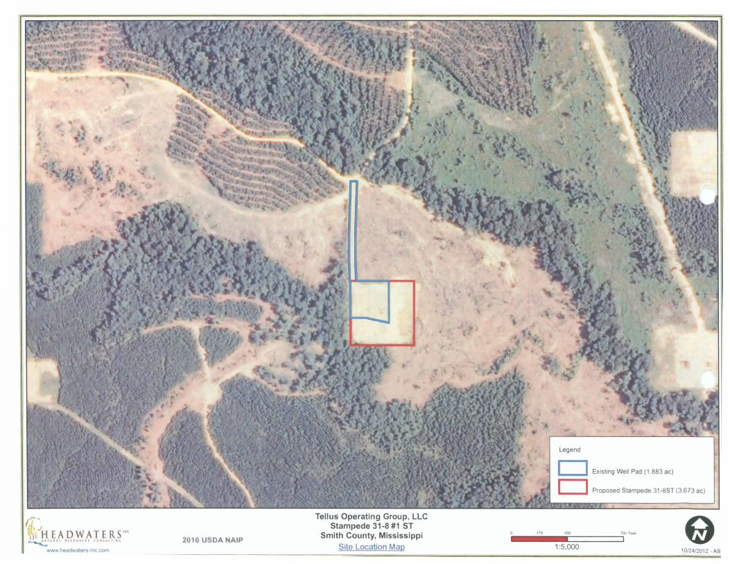
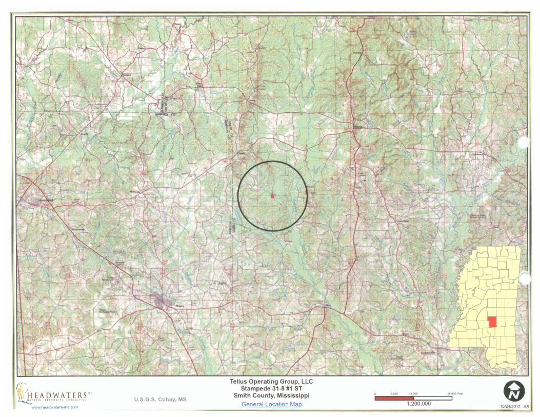
LOCATION The proposed project is located 68 aerial miles southwest of Raleigh Smith County Mississippi in Section 31 Township 2 North Range 7 East The center of the site is located at Latitude 319697ordm North and Longitude 896113ordm West The project is located in the Upper Leaf River watershed (HUC 03170004)
PROJECT PURPOSE The purpose of this project is to expand the currently existing well pad in order to improve the CO2 injection capabilities of this facility in association with the Enhanced Oil Recovery (EOR) operations currently underway within the Stampede Oil and Gas Field
WORK The Applicant proposes to grade and permanently fill approximately 2364 acres of forested wetland in association with the expansion of the existing Stampede 31-8 1 ST well pad
CESAM-RD-I-N 1182012 Public Notice Number SAM-2012-01407-LCB
The proposed project would increase the current size of the Stampede 31-8 1 ST well pad from 200rsquo x 200rsquo (092 ac) to 400rsquo x 400rsquo (367 ac)
AVOIDANCE AND MINIMIZATION The agent provided the following ldquoInitially it was considered to construct a new location adjacent to the Stampede 31-8 1 well site However upon further review it was confirmed that the adjacent habitats are similarly positioned within a low-lying floodplain of Clear Creek and would increase the anticipated wetland impacts from the original concept Due to the potential for increased wetland impacts this alternative was no longer pursued as a viable option Further consideration was taken to utilize the existing Stampede 31-8 1 well site and access road to facilitate the project Utilizing the existing access road and improved well site reduced the anticipated wetland impacts by over 50 from other alternatives As a result it was determined that this was the least environmentally damaging practicable alternative to complete the projectrdquo The USACE has not verified the adequacy of the applicantrsquos avoidance and minimization statement at this time
MITIGATION The applicant proposes to compensate for unavoidable wetland impacts by withdrawing credits from the Cohay Conservation Area permittee responsible mitigation (PRM) area located in Smith County Mississippi The Cohay Conservation Area PRM area is located in the same watershed as the impact site The USACE has not verified the adequacy of the applicantrsquos mitigation proposal at this time
WATER QUALITY The applicant has applied for certification from the State of Mississippi in accordance with Section 401(a)(1) of the Clean Water Act and upon completion of the required advertising a determination relative to certification will be made
COMMENTS This public notice is being distributed to all known interested persons in order to assist in developing facts on which a decision by the US Army Corps of Engineers can be based For accuracy and completeness of the record all data in support of or in opposition to the proposed work should be submitted in writing setting forth sufficient detail to furnish a clear understanding of the reasons for support or opposition The decision whether to issue a permit will be based on an evaluation of the probable impact including cumulative impacts of the proposed activity on the public interest That decision will reflect the national concern for both protection and use of important resources The benefit which reasonably may be expected to accrue from the proposal must be balanced against its reasonably foreseeable detriments All factors which may be relevant to the proposal will be considered including the cumulative effects thereof among those are conservation economics aesthetics general environmental concerns wetlands cultural values fish and wildlife values flood hazards flood plain values land use navigation shoreline erosion and accretion recreation water supply and conservation water quality energy needs safety food production and in general the needs and welfare of the people
The Corps is soliciting comments from the public Federal State and local agencies and officials Indian Tribes and other interested parties in order to consider and evaluate the impacts of this proposed activity Any comments received will be considered by the Corps to determine whether to issue modify condition or deny a permit for this proposal To
CESAM-RD-I-N 1182012 Public Notice Number SAM-2012-01407-LCB
make this decision comments are used to assess impacts on endangered species historic properties water quality general environmental effects and the other public interest factors listed above Comments are used in the preparation of an Environmental Assessment andor an Environmental Impact Statement pursuant to the National Environmental Policy Act Comments are also used to determine the need for a public hearing and to determine the overall public interest of the proposed activity
Any person may request in writing within the comment period specified in this notice that a public hearing be held to consider this application Requests for public hearings shall state with particularity the reasons for holding a public hearing
Evaluation of the probable impacts involving deposits of dredged or fill material into waters of the United States will include the application of guidelines established by the Administrator of the US Environmental Protection Agency
HISTORIC PROPERTIES In accordance with Section 106 of the National Historic Preservation Act and Appendix C of 33 CFR 325 the undertaking defined in this notice is being considered for the potential to affect cultural and historic properties within the permit area Copies of this public notice are being sent to the State Historic Preservation Officer for review
ENDANGERED SPECIES The applicant submitted a request to US Fish and Wildlife Service (USFWS) for a review of project SAM-2009-0626-JMC for which the area of analysis included the proposed Stampede 31-8 1 ST well pad expansion site The USFWS responded electronically stating that there are no known federally listed threatened or endangered species or their habitats within the project area and that they do not anticipate any impacts to listed species as a result of the proposed project Copies of this public notice are being sent to the USFWS for review
Correspondence concerning this Public Notice should refer to Public Notice Number SAM-2012-01407-LCB and should be directed to
US Army Corps of Engineers Mobile District Birmingham Field Office Attn Lewis Brockette 218 Summit Parkway Suite 222 Homewood AL 35209
with a copy to the
Mississippi Department of Environmental Quality Office of Pollution Control Post Office Box 2261 Jackson Mississippi 39225
CESAM-RD-I-N 1182012 Public Notice Number SAM-2012-01407-LCB
Comments should be received no later than 30 days from the date of this Public notice
If you have any questions concerning this publication you may contact the project manager via e-mail at LewisCBrocketteusacearmymil or telephone number (205) 290-9096 Please refer to the above Public Notice number
For additional information about our Regulatory Program please visit our web site at wwwsamusacearmymilRDreg and please take a moment to complete our customer satisfaction survey while you are there Your responses are appreciated and will allow us to improve our services
MOBILE DISTRICT US Army Corps of Engineers Enclosures
Existing Well Pad (1883 ac)
D Proposed Stampede 31-8ST (3673 ac)
Tellus Operating Group LLC Stampede 31-8 1 ST
115 350 700 FMt ~ IAP)X~XI It~ Smith County MississippiIC 2010 USDA NAIP
Site Location Mao 15000wwwheadwaters-inccom 10242012 - AS
9
Tellus Operating Group LLC Stampede 31 -8 1 ST~ J
u a500 tJ ooo 2eooo FMtbull i H E A D W AT E R S Smith County Mississippi IUlA UlOUlCH 0UI tor USGS Cohay MS
General Location Mao 1200000 www headwaters-tnc com
--shy
Legend
D Existing Well Pad (1 883 ac)
D Proposed Stampede 31-8ST(3673ac)
Tellus Operating Group LLC ~ _j Stampede 31-8 1 ST
115 350 700 F- 1 I H E A D W AT E R S c Smith County Mississippi Q~1VIA lfiOUilCII - I lllfo USGS Cohay MS Site Location Mao 15000
wwwheactwaters-tnccom 10242012 middotA~
- SAM-2012-012407-LCB Public Notice
- 2012-012407-LCB PN Maps
-

CESAM-RD-I-N 1182012 Public Notice Number SAM-2012-01407-LCB
Comments should be received no later than 30 days from the date of this Public notice
If you have any questions concerning this publication you may contact the project manager via e-mail at LewisCBrocketteusacearmymil or telephone number (205) 290-9096 Please refer to the above Public Notice number
For additional information about our Regulatory Program please visit our web site at wwwsamusacearmymilRDreg and please take a moment to complete our customer satisfaction survey while you are there Your responses are appreciated and will allow us to improve our services
MOBILE DISTRICT US Army Corps of Engineers Enclosures
Existing Well Pad (1883 ac)
D Proposed Stampede 31-8ST (3673 ac)
Tellus Operating Group LLC Stampede 31-8 1 ST
115 350 700 FMt ~ IAP)X~XI It~ Smith County MississippiIC 2010 USDA NAIP
Site Location Mao 15000wwwheadwaters-inccom 10242012 - AS
9
Tellus Operating Group LLC Stampede 31 -8 1 ST~ J
u a500 tJ ooo 2eooo FMtbull i H E A D W AT E R S Smith County Mississippi IUlA UlOUlCH 0UI tor USGS Cohay MS
General Location Mao 1200000 www headwaters-tnc com
--shy
Legend
D Existing Well Pad (1 883 ac)
D Proposed Stampede 31-8ST(3673ac)
Tellus Operating Group LLC ~ _j Stampede 31-8 1 ST
115 350 700 F- 1 I H E A D W AT E R S c Smith County Mississippi Q~1VIA lfiOUilCII - I lllfo USGS Cohay MS Site Location Mao 15000
wwwheactwaters-tnccom 10242012 middotA~
- SAM-2012-012407-LCB Public Notice
- 2012-012407-LCB PN Maps
-