cesarsc: framework for creating cultural entertainment ...€¦ · creating cultural entertainment...
TRANSCRIPT
Computer Science and Information Systems 13(2):395–425 DOI: 10.2298/CSIS150620006G
CESARSC: Framework for creating Cultural Entertainment Systems with Augmented Reality
in Smart Cities
Ángel García-Crespo1, Israel González-Carrasco1, José L. López-Cuadrado1, Daniel Villanueva1, and Álvaro González2,
1 Computer Science Department Universidad Carlos III de Madrid, Spain, {angel.garcia, israel.gonzalez, joseluis.lopez.cuadrado}@uc3m.es
2 Planet Media Advanced IT Solution. Madrid, Spain [email protected]
Abstract. The areas of application for augmented reality technology are heterogeneous but the content creation tools available are usually single-user desktop applications. Moreover, there is no online development tool that enables the creation of such digital content. This paper presents a framework for the creation of Cultural Entertainment Systems and Augmented Reality, employing cloud-based technologies and the interaction of heterogeneous mobile technology in real time in the field of mobile tourism. The proposed system allows players to carry out a series of games and challenges that will improve their tourism experience. The system has been evaluated in a real scenario, obtaining promising results.
Keywords: Cultural Entertainment System, Augmented Reality, GPS locations.
1. Introduction
Augmented Reality consists of expanding the reality captured by images with information generated by a computer [1]. The areas of application for this technology are clearly heterogeneous, but the content creation tools for these technologies are usually single-user desktop applications. Moreover, there is no online development tool that enables the creation of such digital content.
Originally, virtual reality was used as a technique for rehabilitation in different areas [2]. Thus, Wilson and others assert that the main benefits of applying these techniques involve the ability to create activities in a simulator, without the limitations imposed by their disability, thereby allowing people with disabilities to perform the actions safely [3]. For example, such exercises can be simulated in a virtual kitchen without the dangers associated with a real one (a fire, for example). There have been various approaches to therapy based on virtual reality; for example Jack et al. propose a virtual reality system in which a patient can perform the exercises with two gloves that allow interaction with the system [4].
396 Garcia-Crespo et al.
Furthermore, Augmented Reality presents a promising future, being an emerging technology with interesting potential applications in many domains [5]. Among them, Cultural Entertainment Systems (CES) take an important place. These systems are conceived as computer software created for general entertainment and are based on the interaction between one or more persons with an electronic device that runs common software. According to the 2011 report of the World Tourism Organization1, Spain is the fourth country in the world in terms of the number of foreign tourists who visit the country annually, with over 53 million tourists in 2010 [6]. Tourism, today, is one of the mainstays of the economy in Spain, representing approximately 10% of the country's Gross Domestic Product. Regarding sector revenues by country, Spain is the second country in the world, after the United States.
At the same time a Smart City (SC) is a city that makes a conscious effort to use technology to improve efficiency and quality of life of its citizens. Among the actors involved, the most relevant are governments, citizens and private firms. Governments are in the middle of the process, between citizens and companies, and have a dual function: promoting culture and providing services for citizens. Furthermore, citizens are the recipients of the actions that have to be developed and also the beneficiaries of the process. Finally, private firms, provide, on the one hand, tools and technologies that enable citizens to develop their business efficiently, and on the other hand, they will be the beneficiaries of contracting out public services in cities. So being a Smart City means being a city that offers higher quality services which are more intelligent, more accessible and at a lower cost [7].
Following these trends, this paper presents CESARSC which is a framework for creating Cultural Entertainment Systems (CES) with Augmented Reality (AR) in Smart Cities (SC). CESARSC is based on augmented and mixed reality technology within the domain of mobile tourism, being a novel solution for travel navigation and assistance applications. Despite the current research trends in this area, Pirker et al. conclude that further research is necessary in the domain of usability, advanced playful design, further interaction possibilities and improved technology and feature support [8].
Therefore, the novelty of this research is the definition of a framework for creating a collaborative CES, with the capacity to model routes including new elements such as AR features, gamification, geolocation, and so on. This framework is implemented in a cloud-based platform with the interaction of mobile devices which can also be integrated into a Smart City environment in order to promote the tourism sector of a city. Furthermore, for the generation of Augmented Reality-based effects there are no tools that allow online development with the collaboration of multiple users, this feature being an important novel component of CESARSC in the form of a collaborative CES too, as there is no online development tool that enables the creation of such digital content with these features. Another innovation of CESARSC is its reliance on its own usability aspect; it enhances the traditional user experience while interacting with a mobile device in a Smart City environment.
The remainder of the paper is structured as follows. Section 2 reviews relevant studies and the background to the research. Section 3 provides the motivation for research and the theoretical foundations of CESARSC. Section 4 describes the proposed framework architecture and Section 5 presents the system implementation, as a cloud-based platform, and proof of concept within a real scenario where the users can interact
1 http://www2.unwto.org/
CESARSC: Framework for creating CES in Smart Cities 397
with their own mobile devices. Finally, Section 6 summarizes the main conclusions of this study and outlines future research.
2. Background
The CESARSC framework includes Augmented Reality features and mobile device communication in order to give the users the freedom to move around the city and to interact with the environment in real time.
In this context, Augmented Reality and mobile computing are often mentioned together, as many mobile computing platforms provide continuous access to information [9]. The combination of mobile computing and Augmented Reality into a single system, enhances the power of computers to interact and communicate in the real world and to be accessible at any time and in any place [10, 11].
As computers increase in power and decrease in size, new mobile and wearable computing applications are rapidly becoming feasible, allowing users access to online resources at any time and in any place [12]. The potential applications in many domains, such as environmental monitoring, safety and security, home and office productivity and guided experience of cultural activities, offer new types of expression in art and entertainment [12, 13]. For example, Burker et al., present architecture for art and entertainment [14]. Alan et al., present assistive technologies, enabling users to easily locate Internet content related to the TV program they are watching [15], and a tool to improve educational processes in abstract or technical courses, by providing mobile Augmented Reality [16].
Another feature of the CESARSC framework is the cloud-based implementation and the mobile communication features, which provides full access to the platform at any time and in any place. In this sense, the evolution of mobile devices and advances in cloud resources provide both an opportunity and challenge for mobile applications. For example, applications in smart cities are used, among others, in a collection of smart computing technologies which are applied to critical infrastructure components and services [16]. Taking advantage of the cloud applications for a novel cloud-based discovery framework, which addresses the core components of mobile Web service discovery and which was proposed in [17]. Fernando et al., present a taxonomy based on an extensive survey of mobile cloud computing research and discusses the different approaches taken to tackle these issues [18].
As Virtual Reality technologies continue to advance, the possibilities for these technologies within the tourism sector are growing [19]. It is quickly becoming apparent that VR may have a significant impact on tourism and offers myriad opportunities to both tourism researchers and professionals [20, 21]. Huang et al., present a research framework by identifying the exploration of the role and significance of positive emotion in the context of virtual learning. It is applied to building the connection between tourism education and virtual worlds [22].
Moreover, future technologies in smart cities rely on perceivable or ubiquitous sensing, and anytime / anywhere access and control. The terms of infrastructure (including sensors, personal technologies, smart phones and use of the Internet) allow the exploration of implications which might be considered for the future of the economy, welfare and quality of life in our cities [23]. These technologies comprise an
398 Garcia-Crespo et al.
ecosystem of products, services, companies, people and society that are working together creatively to foster innovation within the city.
Taking these trends into account, CESARSC’s main motivation is the possibility to promote tourism by means of a digital platform integrated into the smart cities infrastructure.
Since their introduction over 40 years ago, frameworks of digital entertainment games have become one of the most popular leisure activities globally [24]. Different applications with technologies such as Smart City, Augmented Reality and Cloud Computing, provide citizens with tools for developing their business efficiently with higher quality and greater intelligence, so that CESARSC binds interaction of heterogeneous mobile technologies in this field.
Nowadays, mobile devices, Smartphones, tablets, and so on have a high level of market penetration and new trends in technologies have allowed the emergence of new products or devices such as Head-mounted Display. In this sense, new technological advances have enabled manufacturers to create glasses based on Augmented Reality technology. Among those using this technology, the following are worth mentioning: the Google project (Project Glass) [25], the EPSON (Moverio BT-100) [26], the Olympus (MEG4.0) [27], Sony Head-Mounted 3D Display [28], Canon Augmented-Reality Platform [29] and the Apple Patent [30]. In Spain of note is the project of creating subtitled glasses, led by scientists at Carlos III University in Madrid and carried out in collaboration with the Spanish Centre for Subtitling and Audiodescription (CESyA). This project allows the display of subtitles through a small screen above the right lens of the glasses and was regarded as one of the world's best inventions of 2007 by Time magazine [31].
In recent years, Augmented Reality applications developed for mobile device platforms, such as Android or iPhone, have increased their presence significantly in online application stores (Google Play and Apple Store for example). These applications are beginning to take advantage of Augmented Reality technology to offer the end user a different and advantageous experience [32].
Finally, as for the generation of Augmented Reality-based effects, there are several tools that will facilitate the creation of applications with these features. With these toolkits, developers will be able to comprehensively implement Augmented Reality experiences, from the initial concept or idea to final product delivery. However, none of these tools allow online development with the collaboration of multiple users. This feature is included in CESARSC, as a novel component for achieving a collaborative CES.
With the aim of responding to the aforementioned needs, this paper presents CESARSC, a cloud-based platform combining AR features, gamification and geolocation in a Smart City environment. In this context, the challenge of CESARSC will be, on the one hand, to obtain a collaborative CES, based-on Augmented Reality technologies, and on the other hand, to be available for non-expert customers with entailing excessive cost.
CESARSC: Framework for creating CES in Smart Cities 399
3. Motivation of Research
3.1. Trends and Opportunity
The field for this research is identified in all the current and potential owners of a latest generation mobile device, typically a smartphone, who are interested in making a trip in their own city or in a foreign one.
The results of research carried out by the International Telecommunication Union (ITU2) in 2013 show that there are almost as many mobile-cellular subscriptions as people in the world, with more than half in the Asia-Pacific region (3.5 billion out of 6.8 billion total subscriptions) [33]. In addition, a continuous high growth rate of mobile broadband (more than 2 billion subscriptions worldwide was registered at the end of 2013); furthermore, mobile -broadband subscriptions have climbed from 268 million in 2007 to 2.1 billion in 2013; data that reflect an average annual growth rate of 40%, making mobile broadband the most dynamic ICT market.
At the beginning of 2013, the smartphone was predicted to become a mass market phenomenon in a study conducted by accountants from Deloitte who also estimated the number of active phones with either a touch screen or an alphabet keyboard to be 2 billion by the end of the year [34]. Deloitte’s study predicts that what was once a luxury device is destined to become an everyday object worldwide. In addition to these predictions, and according to a new forecast from the International Data Corporation (IDC3), tablet shipments were expected to grow by 58.7% year after year in 2013 reaching 229.3 million units, up from 144.5 million units the previous year. The Worldwide tablet market share by screen size was 55% until 2013 and is predicted to increase to 57% in 2017 for screens of less than 8 inches [35].
Furthermore, despite the current general instability, the travel & tourism industry remains a fundamental engine of growth, representing nearly 10 % of global economic activity, taking into account associated services. The 2013 Travel and Tourism Competitiveness Report includes ICT infrastructures as one of the factors of T&T competitiveness as well as digitalization and the fact that mobile devices are considered one of the external drivers of change in the T&T industry [36].
Nowadays, the ongoing digitization has made a faster and more effective dissemination of news. As a result, consumers are becoming more flexible in purchasing decisions, being often led by price-versus-quality transparency when organizing their trips. Hence the consumers base their decisions on tastes and preferences. Therefore, the profile of the international traveler is constantly changing. New demands are unfolding in developing regions such as the BRIC countries, and tourists from Asia, China and Latin America are quite different compared with the typical western traveler. Basically for these reasons, profiling these emerging kinds of travelers from a business point of view could be of interest; as could looking at these facts as input for developing appropriate and customized innovative ideas in order to reach them.
2 http://www.itu.int/es/Pages/default.aspx 3 http://www.idc.com//home.jsp
400 Garcia-Crespo et al.
An important question to answer is what technology development objectives must be met in order to address the market opportunities outlined by this research.
According to a forecast related to Google glasses from IMS Research, now part of IHS Inc. “Shipments of smart glasses may rise as high as 6.6 million units in 2016, up from just 50,000 in 2012, making a total of 9.4 million units for the five-year period” [37]. However, the same report says:” the success of Google Glass will depend primarily on the applications developed for it”. So it is possible to suppose that smart glasses will leave the visionaries sure to find a reply in the mass market only if ways to offer useful information about wearing smart glasses are found. In other words widespread “casual wearing of smart glasses” by technology consumers will be allowed only by the distribution of effective augmented systems. For these reasons, the final result of the research presents important innovative characteristics that open several possibilities for software development to best fit future technology user needs.
Despite concern about mobile application development and specifically the current final users’ landscape, it is clear that smart glasses or similar technologies are not diffused enough, so the main source of value for the final user of the app consists of the route generation with related benefits of saving time in planning a trip and added details regarding the places to visit.
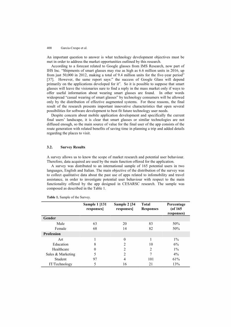
3.2. Survey Results
A survey allows us to know the scope of market research and potential user behaviour. Therefore, data acquired are used by the main function offered for the application.
A survey was distributed to an international sample of 165 potential users in two languages, English and Italian. The main objective of the distribution of the survey was to collect qualitative data about the past use of apps related to infomobility and travel assistance, in order to investigate potential user behaviour with respect to the main functionality offered by the app designed in CESARSC research. The sample was composed as described in the Table 1.
Table 1. Sample of the Survey.
Sample 1 [131 responses]
Sample 2 [34 responses]
Total Responses
Percentage (of 165
responses) Gender
Male 63 20 83 50% Female 68 14 82 50%
Profession Art 1 0 1 1%
Education 8 2 10 6% Healthcare 0 2 2 1%
Sales & Marketing 5 2 7 4% Student 97 4 101 61%
IT/Technology 5 16 21 13%
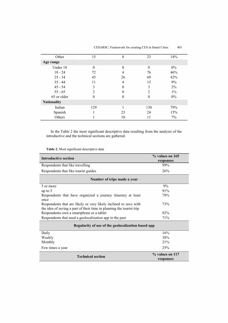
CESARSC: Framework for creating CES in Smart Cities 401
In the Table 2 the most significant descriptive data resulting from the analysis of the
introductive and the technical sections are gathered.
Table 2. Most significant descriptive data
Introductive section % values on 165 responses
Respondents that like travelling 99% Respondents that like tourist guides 26%
Number of trips made a year
5 or more 9% up to 5 91% Respondents that have organized a journey itinerary at least once
78%
Respondents that are likely or very likely inclined to save with the idea of saving a part of their time in planning the tourist trip
73%
Respondents own a smartphone or a tablet 82% Respondents that used a geolocalization app in the past 71%
Regularity of use of the geolocalization based app
Daily 16% Weekly 38% Monthly 21% Few times a year 25%
Technical section % values on 117 responses
Other 15 8 23 14% Age range
Under 18 0 0 0 0% 18 - 24 72 4 76 46% 25 - 34 43 26 69 42% 35 - 44 11 4 15 9% 45 - 54 3 0 3 2% 55 - 65 2 0 2 1%
65 or older 0 0 0 0% Nationality
Italian 129 1 130 79% Spanish 1 23 24 15% Others 1 10 11 7%
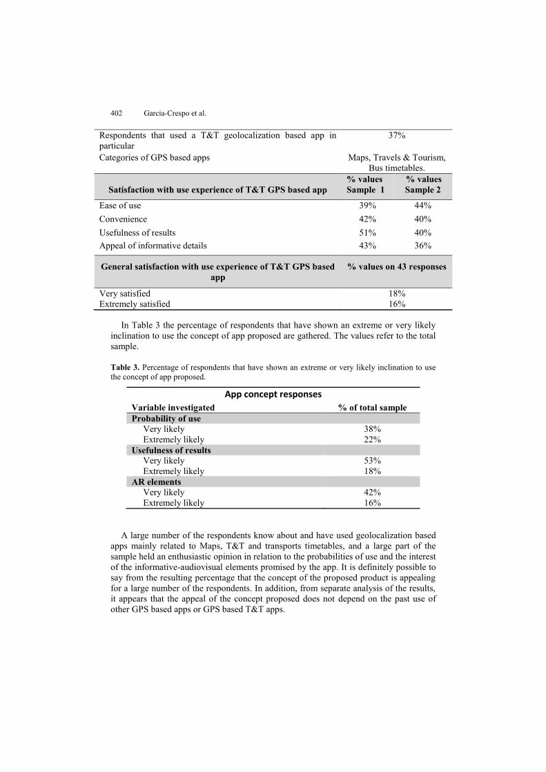
402 Garcia-Crespo et al.
Respondents that used a T&T geolocalization based app in particular
37%
Categories of GPS based apps Maps, Travels & Tourism, Bus timetables.
Satisfaction with use experience of T&T GPS based app
% values Sample 1
% values Sample 2
Ease of use 39% 44% Convenience 42% 40% Usefulness of results 51% 40% Appeal of informative details 43% 36%
General satisfaction with use experience of T&T GPS based app
% values on 43 responses
Very satisfied 18% Extremely satisfied 16%
In Table 3 the percentage of respondents that have shown an extreme or very likely
inclination to use the concept of app proposed are gathered. The values refer to the total sample.
Table 3. Percentage of respondents that have shown an extreme or very likely inclination to use the concept of app proposed.
App concept responses
Variable investigated % of total sample Probability of use Very likely 38% Extremely likely 22% Usefulness of results Very likely 53% Extremely likely 18% AR elements Very likely 42% Extremely likely 16%
A large number of the respondents know about and have used geolocalization based
apps mainly related to Maps, T&T and transports timetables, and a large part of the sample held an enthusiastic opinion in relation to the probabilities of use and the interest of the informative-audiovisual elements promised by the app. It is definitely possible to say from the resulting percentage that the concept of the proposed product is appealing for a large number of the respondents. In addition, from separate analysis of the results, it appears that the appeal of the concept proposed does not depend on the past use of other GPS based apps or GPS based T&T apps.
CESARSC: Framework for creating CES in Smart Cities 403
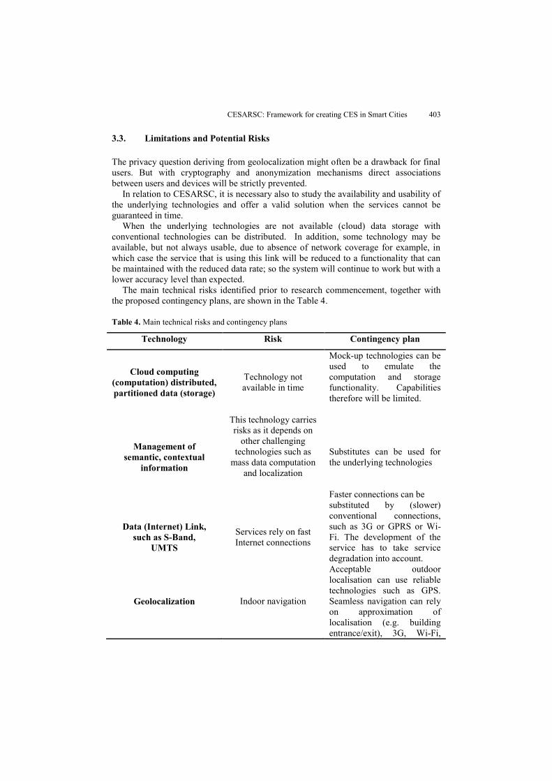
3.3. Limitations and Potential Risks
The privacy question deriving from geolocalization might often be a drawback for final users. But with cryptography and anonymization mechanisms direct associations between users and devices will be strictly prevented.
In relation to CESARSC, it is necessary also to study the availability and usability of the underlying technologies and offer a valid solution when the services cannot be guaranteed in time.
When the underlying technologies are not available (cloud) data storage with conventional technologies can be distributed. In addition, some technology may be available, but not always usable, due to absence of network coverage for example, in which case the service that is using this link will be reduced to a functionality that can be maintained with the reduced data rate; so the system will continue to work but with a lower accuracy level than expected.
The main technical risks identified prior to research commencement, together with the proposed contingency plans, are shown in the Table 4.
Table 4. Main technical risks and contingency plans
Technology Risk Contingency plan
Cloud computing
(computation) distributed, partitioned data (storage)
Technology not available in time
Mock-up technologies can be used to emulate the computation and storage functionality. Capabilities therefore will be limited.
Management of semantic, contextual
information
This technology carries risks as it depends on
other challenging technologies such as
mass data computation and localization
Substitutes can be used for the underlying technologies
Data (Internet) Link, such as S-Band,
UMTS
Services rely on fast Internet connections
Faster connections can be substituted by (slower) conventional connections, such as 3G or GPRS or Wi-Fi. The development of the service has to take service degradation into account.
Geolocalization Indoor navigation
Acceptable outdoor localisation can use reliable technologies such as GPS. Seamless navigation can rely on approximation of localisation (e.g. building entrance/exit), 3G, Wi-Fi,
404 Garcia-Crespo et al.
Bluetooth and pre-compiled detailed maps can help at transferring points based on known coordinates (e.g. building’s entrance/exit)
3.4. Innovative Services
CESARSC will create a set of innovative Future Internet-based scenarios with services related to the needs of the main beneficiaries identified (Table 5).
Travelers’ Scenario
Table 5. Scenario 1 of CESARSC
Scenario 1: Exploitation of the tourist Framework
Number Service Name Description 1.1a Itinerary generation The user sets the parameters to create
the itinerary by choosing: the combination kind of user/part of the day the distance range where the potential itinerary steps have to be selected the transport mode used to move
The user chooses what mode to use to visualize the route within two possibilities: AR mode, Map visualization mode; online services provide an optimized (in terms of time) itinerary by the selected mode
1.1b Itinerary generation User visualizes “My itineraries” Page; the list of itineraries followed in the past and available at that moment will be shown; the user chooses to take an available itinerary and the mode to use on the assisted route; the online services provide the optimized best itinerary by the selected mode.
1.2 Itinerary assistance Depending on the itinerary mode selected by the user a 2D map of the path is shown with indications of the
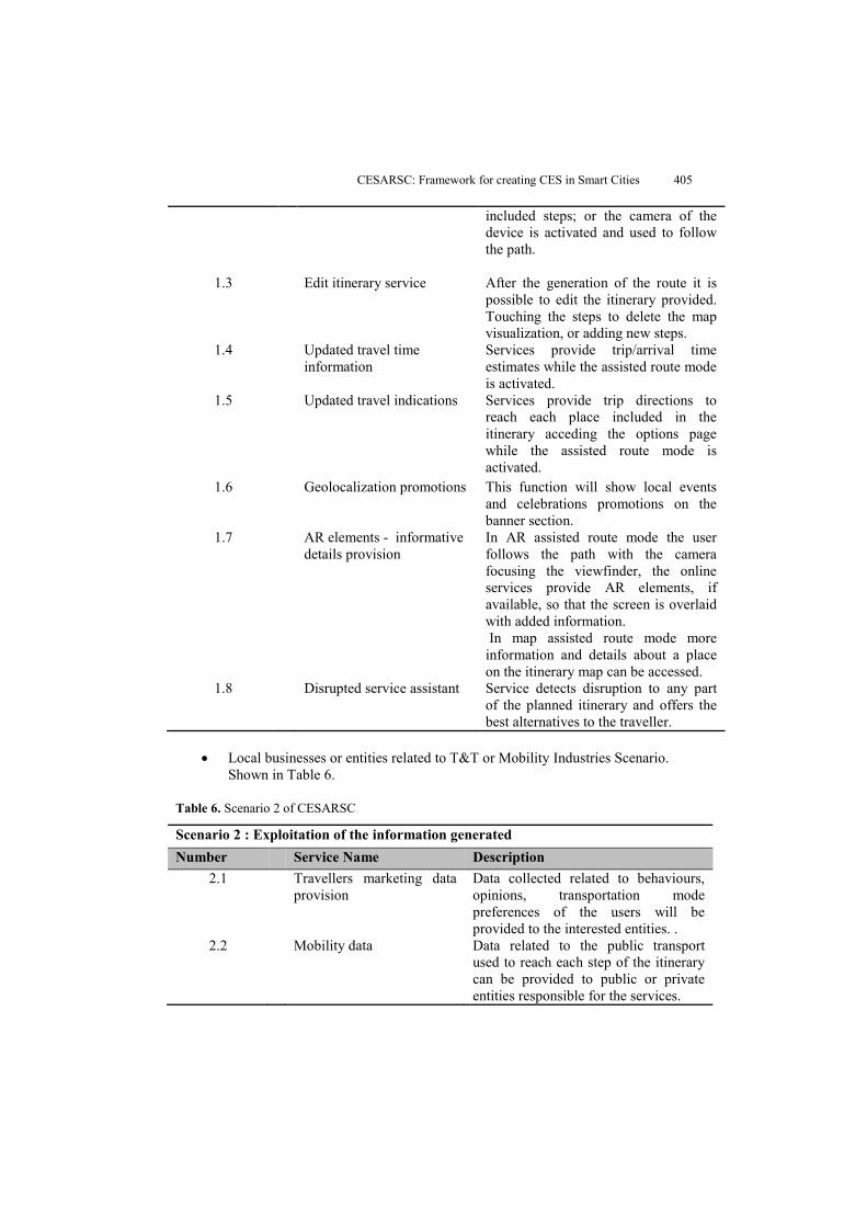
CESARSC: Framework for creating CES in Smart Cities 405
included steps; or the camera of the device is activated and used to follow the path.
1.3 Edit itinerary service After the generation of the route it is possible to edit the itinerary provided. Touching the steps to delete the map visualization, or adding new steps.
1.4 Updated travel time information
Services provide trip/arrival time estimates while the assisted route mode is activated.
1.5 Updated travel indications Services provide trip directions to reach each place included in the itinerary acceding the options page while the assisted route mode is activated.
1.6 Geolocalization promotions
This function will show local events and celebrations promotions on the banner section.
1.7 AR elements - informative details provision
In AR assisted route mode the user follows the path with the camera focusing the viewfinder, the online services provide AR elements, if available, so that the screen is overlaid with added information. In map assisted route mode more information and details about a place on the itinerary map can be accessed.
1.8 Disrupted service assistant Service detects disruption to any part of the planned itinerary and offers the best alternatives to the traveller.
Local businesses or entities related to T&T or Mobility Industries Scenario.
Shown in Table 6.
Table 6. Scenario 2 of CESARSC
Scenario 2 : Exploitation of the information generated Number Service Name Description
2.1 Travellers marketing data provision
Data collected related to behaviours, opinions, transportation mode preferences of the users will be provided to the interested entities. .
2.2 Mobility data Data related to the public transport used to reach each step of the itinerary can be provided to public or private entities responsible for the services.
406 Garcia-Crespo et al.
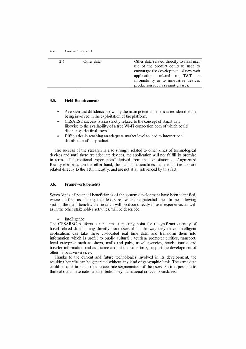
2.3 Other data Other data related directly to final user use of the product could be used to encourage the development of new web applications related to T&T or infomobility or to innovative devices production such as smart glasses.
3.5. Field Requirements
Aversion and diffidence shown by the main potential beneficiaries identified in being involved in the exploitation of the platform.
CESARSC success is also strictly related to the concept of Smart City, likewise to the availability of a free Wi-Fi connection both of which could discourage the final users
Difficulties in reaching an adequate market level to lead to international distribution of the product.
The success of the research is also strongly related to other kinds of technological
devices and until there are adequate devices, the application will not fulfill its promise in terms of “sensational experiences” derived from the exploitation of Augmented Reality elements. On the other hand, the main functionalities included in the app are related directly to the T&T industry, and are not at all influenced by this fact.
3.6. Framework benefits
Seven kinds of potential beneficiaries of the system development have been identified, where the final user is any mobile device owner or a potential one. In the following section the main benefits the research will produce directly in user experience, as well as in the other stakeholder activities, will be described.
Intelligence:
The CESARSC platform can become a meeting point for a significant quantity of travel-related data coming directly from users about the way they move. Intelligent applications can take these co-located real time data, and transform them into information which is useful to public cultural / tourism promoter entities, transport, local enterprise such as shops, malls and pubs, travel agencies, hotels, tourist and traveler information and assistance and, at the same time, support the development of other innovative services.
Thanks to the current and future technologies involved in its development, the resulting benefits can be generated without any kind of geographic limit. The same data could be used to make a more accurate segmentation of the users. So it is possible to think about an international distribution beyond national or local boundaries.
CESARSC: Framework for creating CES in Smart Cities 407
Efficiency: The most significant results will be: time and cost savings for the final users and ease in addressing the business offer for involved local companies through personalized advertising.
Performance:
The intelligence applied to itinerary planning and tourist assistance can generate reduction of travel time uncertainty and an improvement in generalized mobility services, by means of faster, shorter and more comfortable ways to travel by responsible entity’s transport initiatives.
In addition, the final users’ feedback will be transformed into a knowledge base in
order to improve the commercial activities provided by the involved local partners and to contribute to the generation of other innovative initiatives connected to mobility and entertainment, especially in the field of augmented reality and its future applications. Previously the main benefits have been described–along with the objectives of the research related to the partners involved in using its results.
Some possible consequences could be derived from the Social Networks approach of the research. The main results in these terms could be represented by the formation of travelers’ groups within which exchange of knowledge, experiences and opinions could be carried out. This information can be exploited to provide recommendations, meet market trends and so on
3.7. Exploitation Framework
What means will be used to deliver value to all the beneficiaries in order to entice them to pay for that value, converting those payments to profit?
Contents model. The data collected could be sold to web sites or businesses or
entities related to T&T or mobility industries. Promotion model. Local commercial business, for example hotels, shops and
cinemas, will promote their offer by banners shown to the final users or by obtaining a higher visibility level in the generation of results. This will be possible by the payment of an annual fee.
Cultural incentive model. Public entities involved in exploiting the platform will be able to promote some seasonal or sporadic events such as public concerts, festivals and holidays and art exhibitions directly to final users at the moment they are geolocalized by using the app. This will be possible by the payment of an annual fee or a one off charge.
T&T mobility app store model. A set of innovative applications and services related to T&T, as well as mobility, could be generated and made available online for consumers and operators, starting from the results produced by using the solution.
With respect to other approaches, Barazzetti et al. propose a framework for
Historical Building Information Modelling (HBIM) based on AR [38]. Such frameworks
408 Garcia-Crespo et al.
use AR to include information about buildings in mobile devices that can be used during cultural tours. However, the framework is centred on HBIM processing and representation. CESARSC provides the ability to create and share tours including AR information. Pirker et al. present a location-based application creator that allows the definition of routes with different points of interest and also includes both location information and questions for each point 8. They conclude that further research is necessary in the domain of usability, advanced playful design, further interaction possibilities and improved technology and feature support. With respect to the proposal of Pirker et al, the CESARSC includes AR functionality in the design of the route and user interaction. In addition, CESARSC’s model allows the inclusion of new elements used to create routes. Borrero et al. present a pilot test based on AR and a mobile application in a museum. The experience was based on QR codes and completes a number of missions [39]. The authors conclude that such applications could improve the tourism industry to the extent that they can be extended to more scenarios. Other studies such as Fino et al., Kourouthanassis et al. or Chen also refer to specific applications. The CESARSC framework allows the definition of multiple routes with missions to accomplish, and includes AR elements in the experience [40, 41, 42].
4. Proposed Framework Architecture
4.1. CESARSC Framework Components
The aim of this research is to define a framework, called CESARSC, for the creation of CES in tourism domains, using Augmented Reality and employing cloud-based technologies. Furthermore, the framework developed requires the interaction of heterogeneous mobile technology in the field of SC.
CESARSC framework will also implement a reservation system that will allow buyers to conduct a series of games and augmented reality challenges that will improve their tourism experience in the destination by employing the concept of gamification. Each participant through a mobile device (smartphone or tablet for example), or a Head-Mounted Display (HMD) equipped with a camera such as Augmented Reality glasses, will watch real time images and will receive cultural information from the central computer, potential new destinations or cultural activities to perform at the users’ location.
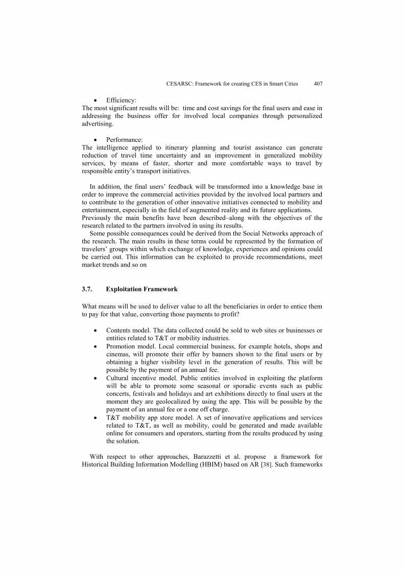
The main components of CESARSC framework are depicted in Fig. 1. The main feature of the CES is that users will be directed from a central computer, via a system controller component from which the information is sent to various roles involved in the system. Users, with heterogeneous mobile technology, will capture images and GPS coordinates relative to where they are at that moment. Elements defined in the CES, and other elements the director of the system wants to send, will be included in these images by means of the mobile client component.
CESARSC: Framework for creating CES in Smart Cities 409
Fig. 1. General architecture: components of the complex system
As shown in Fig. 1, CESARSC architecture is formed by four modules: capturing scenarios module, CES definition tool, system controller and mobile client component.
Capturing Scenarios Module
This module is responsible for capturing the GPS coordinates for the definition of the playground of the CES. The capture of the GPS coordinates is done by means of a smartphone application with GPS features. The user defines points of interest for a given scenario using the smartphone. Users can also take photos and add audio recording related to the point taken.
Definition tool Once the GPS coordinates and the additional information have been collected, the definition tool allows CES to be created. With this tool, users can associate a set of GPS coordinates with a CES, including text or multimedia information for each coordinate. This additional information will be displayed on the mobile device of the CES participants. The definition tool allows all the gathered information to be put together, showing all the points in a map view.
The definition tool also allows the inclusion of GPS coordinates, uploading the contents related to each defined location.
Once the GPS coordinates have been associated with a CES, the definition tool allows the rest of options of said CES to be configured. A defined CES, apart from the GPS points and the additional information available for each point, has a set of attributes that can be configured:
Name of the CES. This name is visualized by the participants and allows the CES to be identified.
Open or restricted CES. A given CES can be publically accessed by every user of the system or only by a list of participants.
Time limit. A time limit can be configured in order to limit the time a CES is available.
Maximum number of participants.
410 Garcia-Crespo et al.
The CES defined is available for all users or only for selected participants depending on the configuration. A CES can also be executed several times by different groups of participants. The system controller is in charge of managing the instances of each CES according to its characteristics.
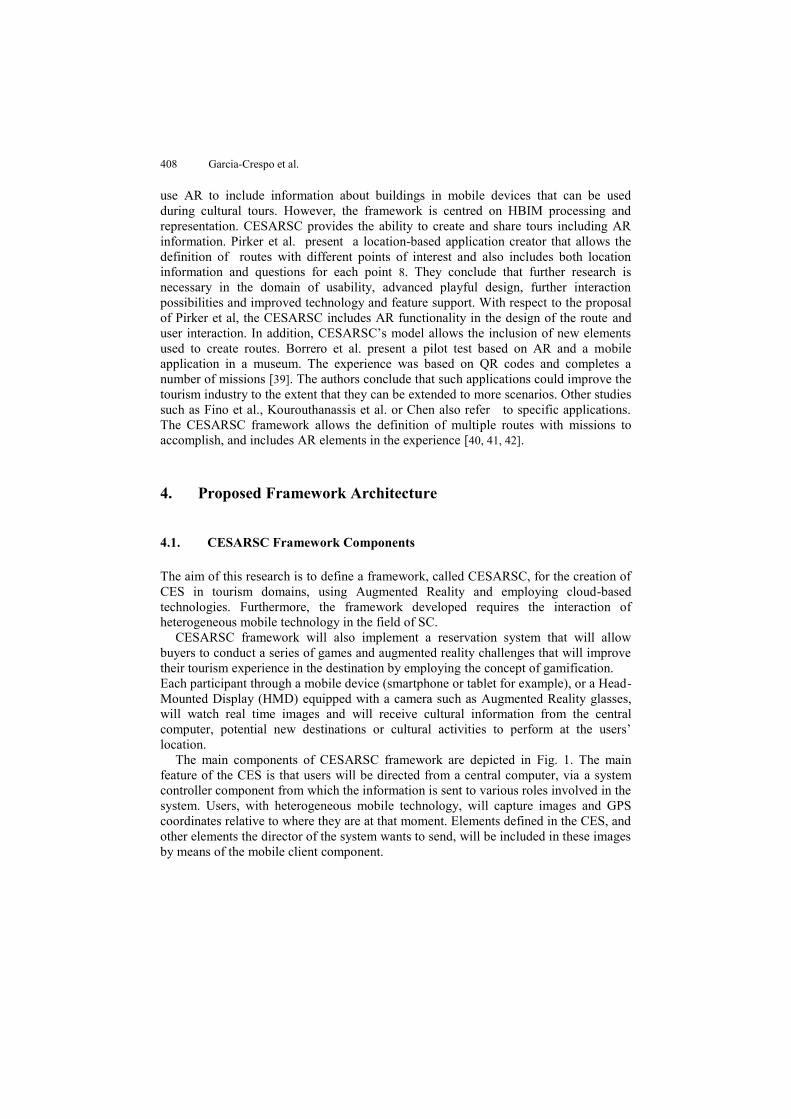
The definition tool is based on a Model Driven Architecture (MDA). The foundation of this architecture lies in the definition of the CES in a device-independent way, so that performance on specific devices will be based on the interpretation of the generic definition of the CES. It will allow the execution of the system in several existing platforms as well as future platforms, by means of specific components for each architecture. Furthermore, modelling each CES in a device-independent way facilitates the creation of different generic components that can be used for different domains on different platforms. It will also ease the process of setting up each CES without device-dependent considerations.
Fig. 2. Process for defining the CES (device-independent)
Fig. 2 depicts the sequence of CES definition. The proposed architecture is open to the incorporation of new components, device dependent or independent. As shown in Fig. 2, the first step consists of the capture of the GPS coordinates in the CES scenario. This capture can be made by means of the capturing scenario module or the definition tool.
CES Controller
Once a CES has been modeled and defined, participants can join it. This means that different groups of users can play several instances of the same game simultaneously. Usually games have all their elements defined (GPS coordinates, landmarks, additional information). However, it is possible to include dynamic information during the game.
Once the CES is defined it is possible to create one or more instances. An instance of a CES is a set formed by the CES definition, a set of users, and a status. The status includes information about the users, their actual position and the status of the elements displayed for the instance. Thus, the same CES definition can be “executed” by several groups of users. A CES controller is in charge of controlling all the instances of CES
CESARSC: Framework for creating CES in Smart Cities 411
running at a given time. Users’ mobile devices involved in the CES establish connections with the CES controller sending their GPS position and the instance of the CES. The CES controller stores the received information in order to determine the status of the CES and returns the available elements to the position received. Also, the CES controller allows dynamic information to be sent to the CES participants. For example, users near shopping centers could receive real time sales information.
The validation of the proposed framework will be made on a centralized controller component, which will include an element of control for the CES director, and a client component from the game for Android platforms.
Mobile Device
The mobile device component interacts with the CES controller sending information about the location of the user and receiving information relative to this location. The information relative to a given location is shown based on Augmented Reality technology. The mobile device is able to receive the dynamic information provided by the CES controller including real time information.
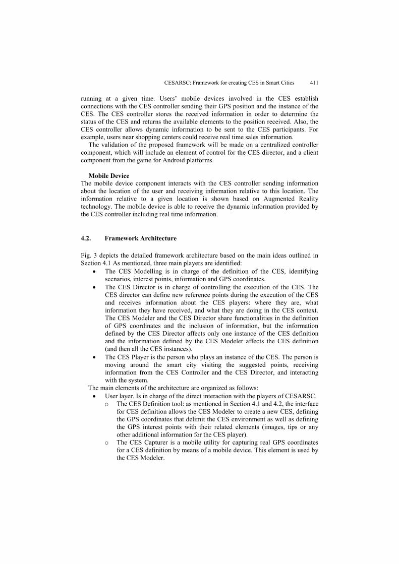
4.2. Framework Architecture
Fig. 3 depicts the detailed framework architecture based on the main ideas outlined in Section 4.1 As mentioned, three main players are identified:
The CES Modelling is in charge of the definition of the CES, identifying scenarios, interest points, information and GPS coordinates.
The CES Director is in charge of controlling the execution of the CES. The CES director can define new reference points during the execution of the CES and receives information about the CES players: where they are, what information they have received, and what they are doing in the CES context. The CES Modeler and the CES Director share functionalities in the definition of GPS coordinates and the inclusion of information, but the information defined by the CES Director affects only one instance of the CES definition and the information defined by the CES Modeler affects the CES definition (and then all the CES instances).
The CES Player is the person who plays an instance of the CES. The person is moving around the smart city visiting the suggested points, receiving information from the CES Controller and the CES Director, and interacting with the system.
The main elements of the architecture are organized as follows: User layer. Is in charge of the direct interaction with the players of CESARSC.
o The CES Definition tool: as mentioned in Section 4.1 and 4.2, the interface for CES definition allows the CES Modeler to create a new CES, defining the GPS coordinates that delimit the CES environment as well as defining the GPS interest points with their related elements (images, tips or any other additional information for the CES player).
o The CES Capturer is a mobile utility for capturing real GPS coordinates for a CES definition by means of a mobile device. This element is used by the CES Modeler.
412 Garcia-Crespo et al.
Fig. 3. Detailed CESARSC Architecture
o The CES Control Tool allows the CES Director to define new instances of CES Definition, selecting the players who play it. The same definition can be instantiated many times and can be played by different players. By means of the CES Control Tool, the CES Director can monitor the execution of a CES instance, receiving the information about where the players are and what information they have received. Also, the CES control tool provides an interface for defining new points dynamically, messages of information of one, several or all players of the CES instance.
o The CES Player tool is the component on the mobile device of the CES Player. It allows the player to receive information, images, tips and new coordinates from the CES Controller. Once the player is moving around the CES environment the CES Player tool checks the current GPS position of the player and sends it to the CES controller. Thus, the CES controller sends information relative to that GPS point and the next point to go. In addition, the CES director can view the current position of all of the players and send information.
Business layer. This layer is in charge of the business logic of CESARSC. The
elements of this layer are: o The CES Modelling module. This module is in charge of the definition of
the CES. A CES definition is formed by a meaningful name and a set of GPS points with related information (mainly text, images and GPS point to go). This module interacts with the CES Definition tool and the CES Capturer to obtain the required information for the CES definition.
Use
rL
ayer
Bu
sin
ess
Lay
erP
ersi
sten
ce
Lay
er
CES PlayerCES Modeller CES Director
CES ModelData
CES Runtime
Data
CES UsersData
CES ModellingModule
CES RuntimeController
CES Control
Tool
CES Player Tool
CES Definition
Tool
CES Capturer
CESARSC: Framework for creating CES in Smart Cities 413
o The CES Runtime Controller. This module is in charge of the execution of instances of CES definitions. It controls the instances of the CES at a given time. On the one hand, for each CES instance, it controls the CES players who play the CES, their current GPS position and the information they are sending and receiving. On the other hand, it provides the CES Director with the information about the players and the CES information and allows the CES director to define dynamic points and information for the players.
Persistence Layer. The persistence layer is in charge of storing the information
generated by CESARSC. This information includes CES definitions as well as information about the concrete executions of CES instances and information about the CES Players. o CES Model Data stores the CES definitions, a set of related GPS points
with additional information. o CES Runtime Data stores information about the execution of CES
definitions by a set of players. As mentioned, an instance of a CES definition is a set formed by the identifier ID of the model, an ID of the instance, IDs of the players of the instance, current position of each player, past positions visited by each player and information received or sent by each player.
o CES Users data. Stores the information about CES Modelers, CES Directors and CES Players. The information about the players is particularly interesting in order to analyze the trends of the CES players: which coordinates they visit frequently, what they do at these coordinates, what is in these coordinates and similar information that can be used to provide the players with richer contents (such as personal recommendations).
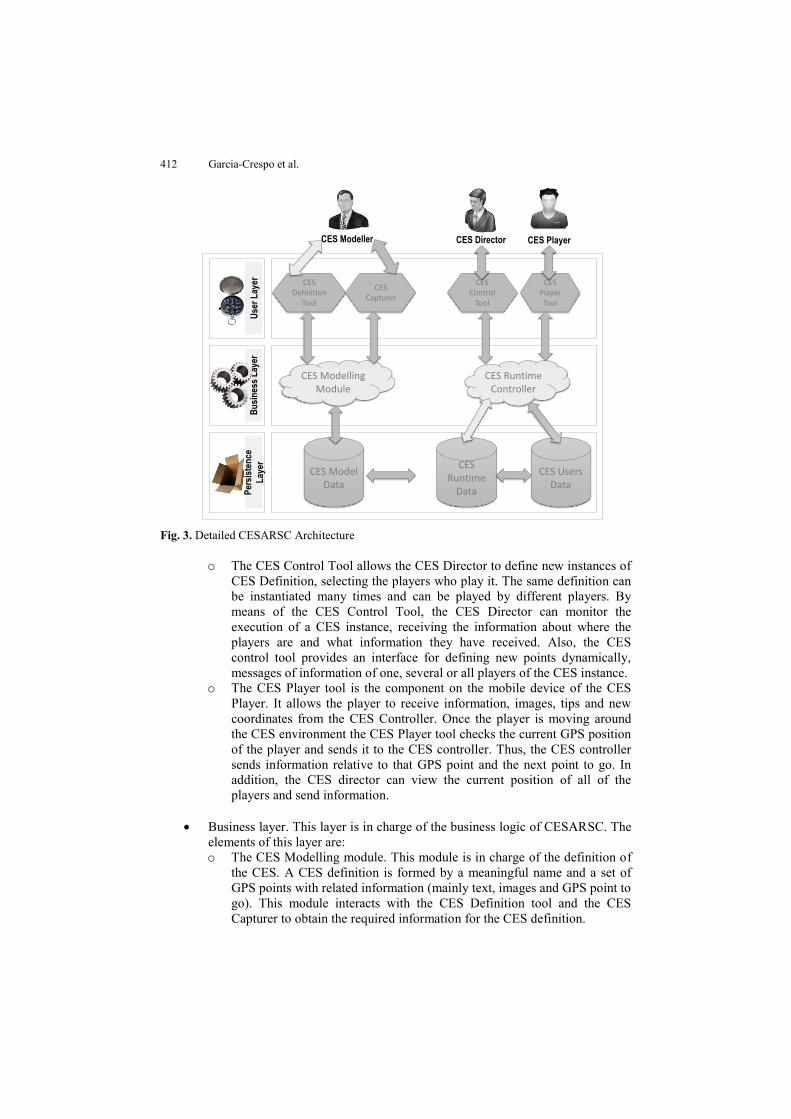
5. System Implementation and Proof of Concept
This section presents the proof of concept of the framework and the architecture described in Section 4.1 and Section 4.2. Based on this architecture, the system implementation has been developed in order to obtain a cloud-based platform and an app for mobile devices (Android and iOS platforms).
The implementation of the platform has been carried out using an Apache server, PHP5, MySQL server as well as an app for Android and iOS. Web interface allows the CES definition as well as CES control (see Fig. 4). CES control includes the monitoring of the users on a given route. The web interface is based on a PHP development which maintains the model defined in a MySQL database. At the same time, the CES players’ view is based on an app (with Android and iOS version) which is able to interact with the defined web services in order to allow the interaction with the defined CES models.
414 Garcia-Crespo et al.
Fig. 4. Detailed CESARSC Implementation
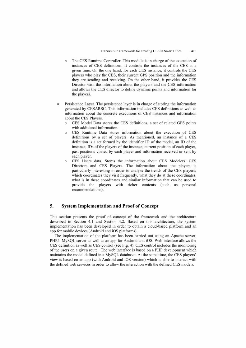
Fig. 5 depicts the interface for defining new CES projects in the cloud platform, providing a meaningful name and a brief description. The CES administrator can manage an existing CES by selecting from a list.
Fig. 5. CES Definition in the cloud-based platform.
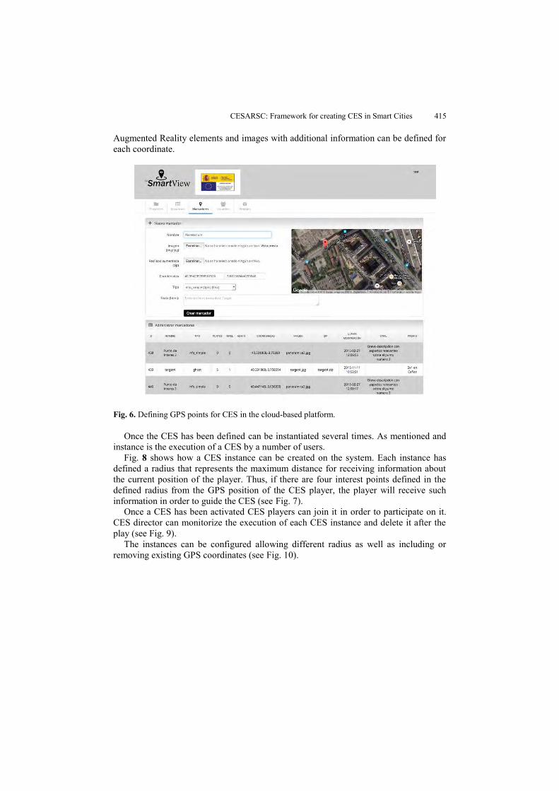
Once the CES has been defined, and the rest of the attributes have been assigned, a set of GPS points can be assigned in order to define a route. Fig. 6 shows the interface for assigning GPS points in the CES definition. With the cloud-based platform, it is possible to select the coordinates using a map view so as to locate a point of interest with accuracy. The list of GPS coordinates can be used with another CES. For example, the Coordinate “Madrid Airport” can be created once, and then used in several CES.
CESARSC: Framework for creating CES in Smart Cities 415
Augmented Reality elements and images with additional information can be defined for each coordinate.
Fig. 6. Defining GPS points for CES in the cloud-based platform.
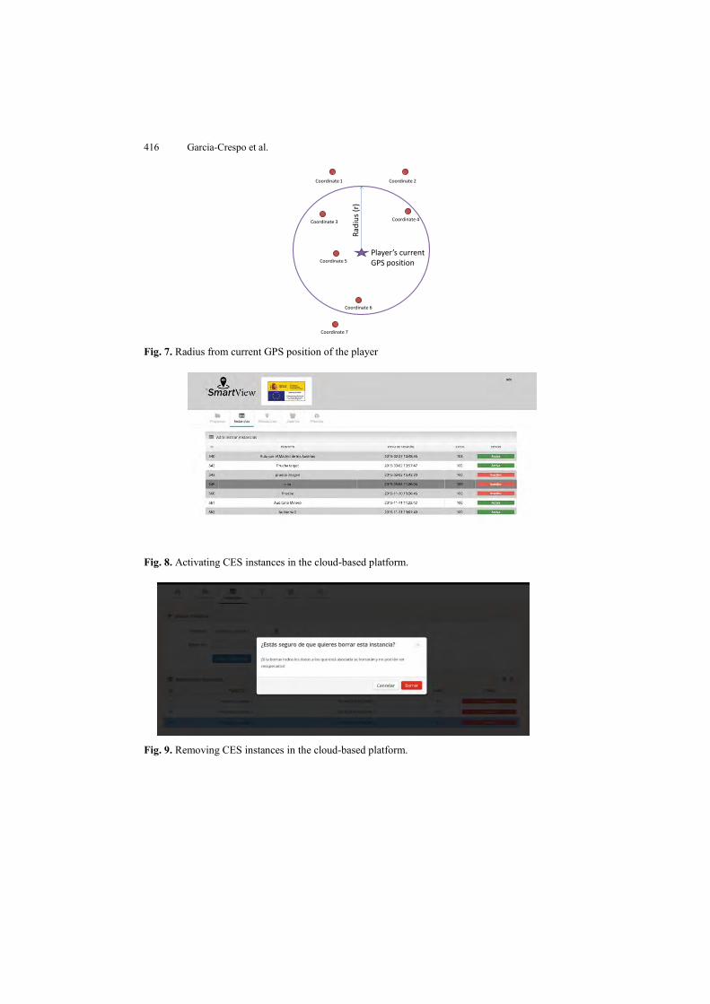
Once the CES has been defined can be instantiated several times. As mentioned and instance is the execution of a CES by a number of users.
Fig. 8 shows how a CES instance can be created on the system. Each instance has defined a radius that represents the maximum distance for receiving information about the current position of the player. Thus, if there are four interest points defined in the defined radius from the GPS position of the CES player, the player will receive such information in order to guide the CES (see Fig. 7).
Once a CES has been activated CES players can join it in order to participate on it. CES director can monitorize the execution of each CES instance and delete it after the play (see Fig. 9).
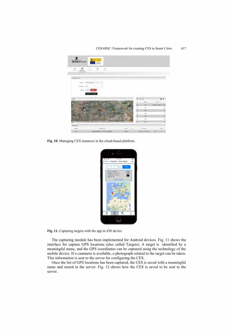
The instances can be configured allowing different radius as well as including or removing existing GPS coordinates (see Fig. 10).
416 Garcia-Crespo et al.
Fig. 7. Radius from current GPS position of the player
Fig. 8. Activating CES instances in the cloud-based platform.
Fig. 9. Removing CES instances in the cloud-based platform.
Player’s currentGPS position
Rad
ius
(r)
Coordinate 1 Coordinate 2
Coordinate 4Coordinate 3
Coordinate 5
Coordinate 6
Coordinate 7
CESARSC: Framework for creating CES in Smart Cities 417
Fig. 10. Managing CES instances in the cloud-based platform.
Fig. 11. Capturing targets with the app in iOS device
The capturing module has been implemented for Android devices. Fig. 11 shows the interface for capture GPS locations (also called Targets). A target is identified by a meaningful name, and the GPS coordinates can be captured using the technology of the mobile device. If a cammera is available, a photograph related to the target can be taken. This information is sent to the server for configuring the CES.
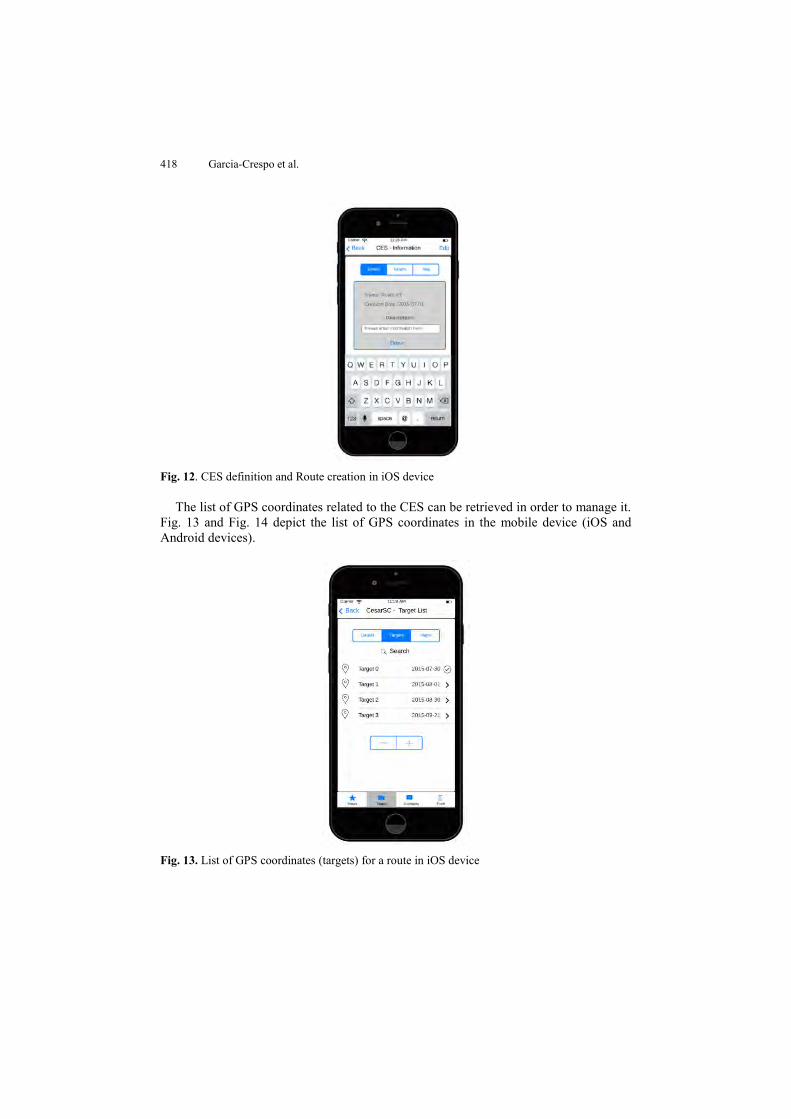
Once the list of GPS locations has been captured, the CES is saved with a meaningful name and stored in the server. Fig. 12 shows how the CES is saved to be sent to the server.
418 Garcia-Crespo et al.
Fig. 12. CES definition and Route creation in iOS device
The list of GPS coordinates related to the CES can be retrieved in order to manage it. Fig. 13 and Fig. 14 depict the list of GPS coordinates in the mobile device (iOS and Android devices).
Fig. 13. List of GPS coordinates (targets) for a route in iOS device
CESARSC: Framework for creating CES in Smart Cities 419
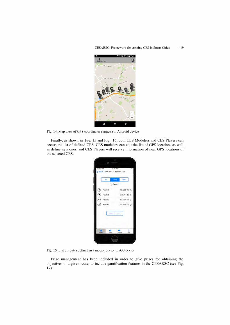
Fig. 14. Map view of GPS coordinates (targets) in Android device
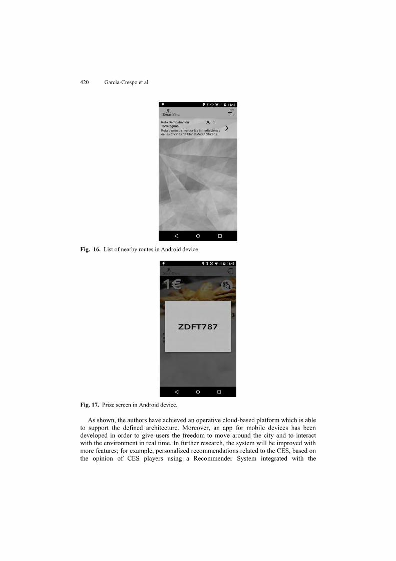
Finally, as shown in Fig. 15 and Fig. 16, both CES Modelers and CES Players can access the list of defined CES. CES modelers can edit the list of GPS locations as well as define new ones, and CES Players will receive information of near GPS locations of the selected CES.
Fig. 15. List of routes defined in a mobile device in iOS device
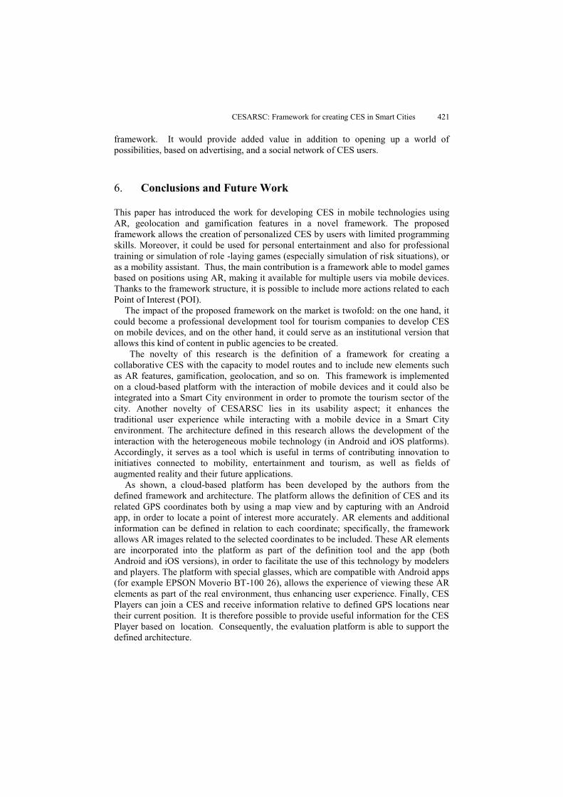
Prize management has been included in order to give prizes for obtaining the objectives of a given route, to include gamification features in the CESARSC (see Fig. 17).
420 Garcia-Crespo et al.
Fig. 16. List of nearby routes in Android device
Fig. 17. Prize screen in Android device.
As shown, the authors have achieved an operative cloud-based platform which is able to support the defined architecture. Moreover, an app for mobile devices has been developed in order to give users the freedom to move around the city and to interact with the environment in real time. In further research, the system will be improved with more features; for example, personalized recommendations related to the CES, based on the opinion of CES players using a Recommender System integrated with the
CESARSC: Framework for creating CES in Smart Cities 421
framework. It would provide added value in addition to opening up a world of possibilities, based on advertising, and a social network of CES users.
6. Conclusions and Future Work
This paper has introduced the work for developing CES in mobile technologies using AR, geolocation and gamification features in a novel framework. The proposed framework allows the creation of personalized CES by users with limited programming skills. Moreover, it could be used for personal entertainment and also for professional training or simulation of role -laying games (especially simulation of risk situations), or as a mobility assistant. Thus, the main contribution is a framework able to model games based on positions using AR, making it available for multiple users via mobile devices. Thanks to the framework structure, it is possible to include more actions related to each Point of Interest (POI).
The impact of the proposed framework on the market is twofold: on the one hand, it could become a professional development tool for tourism companies to develop CES on mobile devices, and on the other hand, it could serve as an institutional version that allows this kind of content in public agencies to be created.
The novelty of this research is the definition of a framework for creating a collaborative CES with the capacity to model routes and to include new elements such as AR features, gamification, geolocation, and so on. This framework is implemented on a cloud-based platform with the interaction of mobile devices and it could also be integrated into a Smart City environment in order to promote the tourism sector of the city. Another novelty of CESARSC lies in its usability aspect; it enhances the traditional user experience while interacting with a mobile device in a Smart City environment. The architecture defined in this research allows the development of the interaction with the heterogeneous mobile technology (in Android and iOS platforms). Accordingly, it serves as a tool which is useful in terms of contributing innovation to initiatives connected to mobility, entertainment and tourism, as well as fields of augmented reality and their future applications.
As shown, a cloud-based platform has been developed by the authors from the defined framework and architecture. The platform allows the definition of CES and its related GPS coordinates both by using a map view and by capturing with an Android app, in order to locate a point of interest more accurately. AR elements and additional information can be defined in relation to each coordinate; specifically, the framework allows AR images related to the selected coordinates to be included. These AR elements are incorporated into the platform as part of the definition tool and the app (both Android and iOS versions), in order to facilitate the use of this technology by modelers and players. The platform with special glasses, which are compatible with Android apps (for example EPSON Moverio BT-100 26), allows the experience of viewing these AR elements as part of the real environment, thus enhancing user experience. Finally, CES Players can join a CES and receive information relative to defined GPS locations near their current position. It is therefore possible to provide useful information for the CES Player based on location. Consequently, the evaluation platform is able to support the defined architecture.
422 Garcia-Crespo et al.
In addition, the nature of this research is clearly horizontal because this particular technology is not only focused on cultural entertainment systems, but has other applications as well; for example, the creation of training simulations for evacuation plans, carrying out tours that include information, allowing POI and even the inclusion of advertising elements. In short, the platform opens up a new world of possibilities for Augmented Reality Content for Multi-device distribution. Finally, the inclusion in the cloud of this technology platform enables real-time access, thereby opening distribution to the PaaS (Platform As A Service) paradigm.
Acknowledgements. This work is supported by the Spanish Ministry of Economy and Competitiveness under the INNPACTO project CL-SMARTVIEW (IPT-2012-1043-410000).
References
1. Wagner, D., Pintaric, T., Ledermann, F., & Schmalstieg, D. (2005). Towards massively multi-user augmented reality on handheld devices. In Pervasive Computing (pp. 208-219). Springer Berlin Heidelberg.
2. Tsang, M. M., & Man, D. W. (2013). A virtual reality-based vocational training system (VRVTS) for people with schizophrenia in vocational rehabilitation.Schizophrenia research.
3. Wilson PN, Foreman N, Stanton D., Virtual reality, disability and rehabilitation. Disability and Rehabilitation, 19(6):213-20. 1997.
4. Jack, D., Roian, R. Merians, A.S., Tremaine M., Burdea, G.C., Adamovich, S.V., Recce, M. and Poizner H. Virtual Reality-Enhanced Stroke Rehabilitation. IEEE Transactions on Neural Systems and Rehabilitation Engineering, 9(3): 308-318. 2001.
5. Kose, U., Koc, D., & Yucesoy, S. A. (2013). An Augmented Reality Based Mobile Software to Support Learning Experiences in Computer Science Courses. Procedia Computer Science, 25, 370-374.
6. World Tourism Organization (2011). UNWTO Annual Report 2011. http://www2.unwto.org/en/publication/unwto-annual-report-2011 (Last visited 15/12/2012).
7. Lee, J. H., Phaal, R., & Lee, S. H. (2012). An integrated service-device-technology roadmap for smart city development. Technological Forecasting and Social Change.
8. Pirker, J., Gütl, C., Weiner, P., & Garcia-Barrios, V. M. (2015). Application Domains for a Location-based Mobile Application Creator. International Journal of Interactive Mobile Technologies, 9(3).
9. Reitmayr, G., & Schmalstieg, D. (2001). Mobile collaborative augmented reality. In Augmented Reality, 2001. Proceedings. IEEE and ACM International Symposium on (pp. 114-123). IEEE.
10. Luo, X. (2009, July). From augmented reality to augmented computing: a look at cloud-mobile convergence. In Ubiquitous Virtual Reality, 2009. ISUVR'09. International Symposium on (pp. 29-32). IEEE.
11. Driver, C., & Clarke, S. (2008). An application framework for mobile, context-aware trails. Pervasive and Mobile Computing, 4(5), 719-736.
12. Burke, J., Friedman, J., Mendelowitz, E., Park, H., & Srivastava, M. B. (2006). Embedding expression: Pervasive computing architecture for art and entertainment. Pervasive and Mobile Computing, 2(1), 1-36.
13. Chang, C., Srirama, S. N., & Ling, S. (2013). Towards an adaptive mediation framework for Mobile Social Network in Proximity. Pervasive and Mobile Computing.
14. Burke, J., Friedman, J., Mendelowitz, E., Park, H., & Srivastava, M. B. (2006). Embedding expression: Pervasive computing architecture for art and entertainment. Pervasive and Mobile Computing, 2(1), 1-36.
CESARSC: Framework for creating CES in Smart Cities 423
15. Messer, A., Kunjithapatham, A., Nguyen, P., Rathod, P., Sheshagiri, M., Cheng, D., & Gibbs, S. (2008). SeeNSearch: A context directed search facilitator for home entertainment devices. Pervasive and Mobile Computing,4(6), 871-888.
16. Chourabi, H., Nam, T., Walker, S., Gil-Garcia, J. R., Mellouli, S., Nahon, K., ... & Scholl, H. J. (2012, January). Understanding smart cities: An integrative framework. In System Science (HICSS), 2012 45th Hawaii International Conference on (pp. 2289-2297). IEEE.
17. Elgazzar, K., Hassanein, H. S., & Martin, P. (2013). DaaS: Cloud-based mobile Web service discovery. Pervasive and Mobile Computing.
18. Fernando, N., Loke, S. W., & Rahayu, W. (2013). Mobile cloud computing: A survey. Future Generation Computer Systems, 29(1), 84-106.
19. Chang, J. W. L. C. H., Hsieh, C. Y., & Huang, Y. T. C. X. T. IEBSR: An Integrated e-Tourism Service for Self-Guided Travel.
20. Guttentag, D. A. (2010). Virtual reality: Applications and implications for tourism. Tourism Management, 31(5), 637-651. ISO 690
21. Garcia Crespo, Á., López-Cuadrado, J. L., Colomo-Palacios, R., González-Carrasco, I., & Ruiz-Mezcua, B. (2011). Sem-Fit: A semantic based expert system to provide recommendations in the tourism domain. Expert systems with applications, 38(10), 13310-13319.
22. Huang, Y. C., Backman, S. J., Chang, L. L., Backman, K. F., & McGuire, F. A. (2013). Experiencing student learning and tourism training in a 3D virtual world: An exploratory study. Journal of Hospitality, Leisure, Sport & Tourism Education, 13, 190-201.
23. Cosgrave, E., Arbuthnot, K., & Tryfonas, T. (2013). Living Labs, Innovation Districts and Information Marketplaces: A Systems Approach for Smart Cities.Procedia Computer Science, 16, 668-677.
24. Boyle, E. A., Connolly, T. M., Hainey, T., & Boyle, J. M. (2012). Engagement in digital entertainment games: A systematic review. Computers in human behavior, 28(3), 771-780.
25. Google Inc. Google's Project Glass. https://plus.google.com/+projectglass/posts (Last visited 15/12/2012).
26. Seiko Epson Corporation. Epson Moverio BT-100. http://www.epson.com/cgi-bin/Store/jsp/Moverio/Home.do (Last visited 15/01/2012).
27. Olympus. Olympus MEG4.0. Wearable Display Prototype. http://www.pcworld.com/ article/258800/olympus_follows_google_glass_with_wearable_display_prototype.html (Last visited 15/12/2012).
28. Sony Corporation. Sony Head-Mounted 3D Display. http://www.sony.co.uk/hub/personal-3d-viewer. (Last visited 15/12/2012).
29. Canon Inc. Canon Augmented-Reality Platform. http://www.pcworld.com/article/ 257789/canon_to_launch_augmentedreality_platform_based_on_headmounted_displays.html (Last visited 15/01/2012).
30. Apple Inc (2012). Peripheral treatment for head-mounted displays. United States Patent. 31. The Spanish Centre of Subtitling and Audiodescription. Reading Glasses Project (Subtitle
Glasses). http://www.cesya.es/files/prensa/071102_time.pdf (Last visited 15/12/2012). 32. Meldrum, D., Glennon, A., Herdman, S., Murray, D., & McConn-Walsh, R. (2012). Virtual
reality rehabilitation of balance: assessment of the usability of the Nintendo Wii® Fit Plus. Disability and Rehabilitation: Assistive Technology,7(3), 205-210.
33. International Telecommunication Union (2013). Measuring the Information Society. Executive Summary 2013.http://www.itu.int/en/ITU-D/Statistics/Documents/publications/ mis2013/MIS2013-exec-sum_E.pdf (Last visited 15/12/2012)
34. Deloitte (2013). Technology, Media & Telecommunications Predictions, 2013. http://www.deloitte.com/assets/Dcom-BruneiDarussalam/Local%20Assets/Documents/TMT%20Predictions%202013.pdf (Last visited 15/12/2012)
35. IDC (2013). Forecasts Worldwide Tablet Shipments to Surpass Portable PC Shipments in 2013, http://www.idc.com/getdoc.jsp?containerId=prUS24129713 (Last visited 15/12/2012)
424 Garcia-Crespo et al.
36. Booze & Company (2013). The Global Innovation 1000: Navigating the Digital Future. http://www.booz.com/media/file/BoozCo_2013-Global-Innovation-1000-Study-Navigating-the-Digital-Future.pdf (Last visited 15/12/2012).
37. IHS (2013). Spurred by Google Glass, IHS Forecasts Nearly 10 Million Smart Glasses to Ship from 2012 to 2016. http://press.ihs.com/press-release/design-supply-chain/spurred-google-glass-ihs-forecasts-nearly-10-million-smart-glasses (Last visited 15/12/2012).
38. Barazzetti, L., Banfi, F., Brumana, R., Oreni, D., Previtali, M., & Roncoroni, F. (2015). HBIM AND AUGMENTED INFORMATION: TOWARDS A WIDER USER COMMUNITY OF IMAGE AND RANGE-BASED RECONSTRUCTIONS. ISPRS-International Archives of the Photogrammetry, Remote Sensing and Spatial Information Sciences, 1, 35-42.
39. Borrero, F., Muñoz, P. C. S., & González, G. R. (2015). Gamification techniques in tourism, application test, Casa Mosquera Museum. Sistemas y Telemática, 13(33), 63-76.
40. Fino, E. R., Martín-Gutiérrez, J., Fernández, M. D. M., & Davara, E. A. (2013). Interactive Tourist Guide: Connecting Web 2.0, Augmented Reality and QR Codes. Procedia Computer Science, 25, 338-344.
41. Kourouthanassis, P., Boletsis, C., Bardaki, C., & Chasanidou, D. (2015). Tourists responses to mobile augmented reality travel guides: The role of emotions on adoption behavior. Pervasive and Mobile Computing, 18, 71-87.
42. Chen, W. (2014). Historical Oslo on a handheld device–a mobile augmented reality application. Procedia Computer Science, 35, 979-985.
Angel Garcia-Crespo did his PhD in Industrial Engineering at Universidad Politécnica of Madrid. He received Prize of the Instituto J.A. Artigas institute to the best PhD thesis. He is Executive MBA by the Instituto de Empresa institute. He is an Assistant Professor at the Universidad Carlos III de Madrid University. He is co- Head of the advanced systems integration team. He has actively taken part in European Union projects, such as in a significant number of R&D projects with companies. He is the author of more than 100 papers in congresses and international journals.
Israel Gonzalez-Carrasco is a visiting professor in the Computer Science Department of Universidad Carlos III of Madrid. He holds his PhD degree in Computer Science by this University. He is co-author of several papers in international journals and conferences and his main lines of research are Neural Networks, Internet of Things and Software Engineering. He is involved in international projects and he is also an Editorial Board and Review Board Member for several international journals.
Jose Luis López Cuadrado is a visiting professor in the Computer Science Department of Universidad Carlos III of Madrid. He holds his PhD degree in Computer Science by this University. He is co-author of several papers in international journals and conferences and his main lines of research are Software Engineering, Processes Improvement and Expert Systems. He is involved in international projects and he is also an Editorial Board and Review Board Member for several international journals.

CESARSC: Framework for creating CES in Smart Cities 425
Daniel Villanueva is a researcher in the Computer Science Department of Universidad Carlos III of Madrid. He holds his PhD degree in Computer Science by this University. He is co-author of different papers in international journals and conferences and his main lines of research are Linked Data and Semantics.
Alvaro Gonzalez is an IT Project Manager with a wide experience in IT Projects and IT Service Management Projects for large Companies in different domains and environments.
Received: June 20, 2015; Accepted: April 8, 2016