cft ''6 - usgs · pdf filecft tei-510 trace elements investigations report 510...
TRANSCRIPT

''6URANIUM DEPOSITS OF THE SOUTHERN
PART OF TEE SAN JUAN BASIN,
NEW MEXICO
By L» S. Hilpert and R. H. Moench
CftTEI-510
Trace Elements Investigations Report 510
DEPARTMENT OF THE INTERIOR
GEOLOGICAL SURVEY


IN REPLY REFER TO:
UNITED STATESDEPARTMENT OF THE INTERIOR
GEOLOGICAL SURVEY WASHINGTON as, D. c. October 21, 1959
AEC - 329/9
Mr. Robert D. NiningarAssistant Director for ExplorationDivision of Raw MaterialsU. S. Atomic "Hlnergy CommissionWashington 25, D. G
Dear Bob:
Transmitted herewith are three copies of TEI-510, "Uranium
deposits of the southern part of the San Juan Basin, Hew Mexico,, 11 by
L. S. Hilpert and R. E. Moench, March 1959>
We plan to submit this report for publication in Economic
Geology,,
Sincerely yours,
xd-v \*<~+
Mentis R.- Klepper As&istast- Chlel5 Geologist

TEL-510
UNITED STATES DEPARTMENT OF TES INTERIOR
GEOLOGICAL SURVEY
URANIUM DEPOSITS OF THE SOUTHERN PART OF THE
SAN JUAN BASIN, NEW MEXICO*
By
L. S. Hilpert and R* E. Moench
March 1959
Trace Elements Investigations Report
This preliminary report is distributed without editorial and technical review for conformity with official standards and nomenclature. It is not for public inspection or Quotation.
*This report concerns work done on behalf of the Division of Raw Materials of the U» S. Atomic Energy Commission.

USGS - TEI-510
GEOLOGY AND MINERALOGY
Distribution No. of copies
Division of Raw Materials , Austin ............... 1Division of Raw Materials, Casper ............... 2Division of Raw Materials, Denver t .............. 1Division of Raw Materials, Grants ............... 2Division of Raw Materials, Lima, Peru ............. 1Division of Raw Materials, Salt Lake City ........... 3Division of Raw Materials, Washington ............. 3Grand Junction Operations Office ............... 6Technical Information Service Extension, Oak Ridge ...... 6
U. S. Geological Survey:Alaskan Geology Branch, Menlo Park .............. 1Foreign Geology Branch, Washington .............. 1Fuels Branch, Denver ..................... kGeochemistry and Petrology Branch,.Washington ......... 1Geophysics Branch, Washington ................. 1Mineral Deposits Branch, Washington .............. 6TEPCO, Denver ......................... 2TEPCO, Washington ....................... 2

CQOTSNTS
Page
Abstract ............................... r-
Introduction ............................. 7
General geology ........................... 9
Stratigraphy ............................. 10
Structural geology . ......................... 17
Relations of uranium deposits to igneous rocks ............ 25
Uranium deposits ......................*..*» 27
Mineralogy ........................... 2$
Ore minerals .............**,..***... 28
Carbonaceous material ................... 30
Accessory minerals ..................... 31
Deposits in clastic sediments .................. 31
Deposits in limestone ......... ............. 33
The deposit in a sandstone pipe .................. 3-4
Relations of the deposits to structural features ........ 35
Localization and origin ..................... 36
The Jackpile and satellitic deposits .............. 37
The Poison Canyon and associated deposits ............ 44
The uranium deposits north of the Poison Canyon deposit ..... ̂ 7
The Woodrow deposit ....................... ̂6
The Sandy mine ......................... 51
The F-33 mine .......................... 56
Resources in unexplored ground ................... . 57
Summary and conclusions ....................... 59

IfPage
Acknowledgments ............ D .......... D .. fa
References ............................ 62
ILLUSTRATIONS
Figure 1, Index map of north-western New Mexico ..........
2. Geologic map of the southern part of theIn
San Juan Basin ..................... Envelope
3. Diagrammatic geologic section "between theIn
Ambrosia Lake and Laguna districts, New Mexico .,.**. EnvelopeIn
4. Map of part of the Ambrosia Lake *........».. Envelope
5. Geologic sections of the Mbrrison formation in
the Ambrosia Lake district ............... 16
6. Generalized geologic map of part of theIn
Laguna district, New Mexico .............. Envelope
7» Geologic sections of the Morrison formation northIn
of the Poison Canyon mine ............... Envelope
8, Section through top of sandstone pipe inIn
"Jackpile" sandstone, Jackpile mine .......... Envelope
9» Diagrammatic sections through the North oreIn
body, Jackpile mine .................. Envelope
10. Field sketch of top of Jackpile uranium deposit .... 39
11. Field sketch showing displacement of Jackpile
uranium deposit "by diabase sill ............ ̂ 1
12. Photograph of vertical ore rods, Jackpile mine . * ... 43
13 • Geologic "wall map of the Windship deposit ....... 45
14. Diagrammatic section through the Woodrow pipe .... * ^9

Figure 15. Diagrammatic geologic section across Sandy mineIn
area «....«.*........*..*...«. Envelope
16. Section through uranium deposit in the Entrada
sandstone, Sandy mine ..............*. 53
17 • Section across uranium deposit in Todilto
limestone, Sandy mine area .............. 55
18. Generalized geologic map and profile of the• In
F-33 mine ....*................. Envelope
TABLE
Table 1. Sequence of formational units containing uranium
deposits along the southern part of the San JuanIn
Basin, New Mexico .................. Envelope
URANIUM DEPOSITS OF THE SOUTHERN PART OF THE
SAM JUAN BASIN, NEW MEXICO
By L. S. Hilpert and R. H. Moench
ABSTRACT
Since 1950 about 50 million tons of uranium ore has been discovered
along the southern margin of the San Juan Basin, New Mexico. Here the
exposed sequence of sedimentary rocks ranges in age from Permian to
Cretaceous, and this sequence is associated with intrusive and extrusive
rocks of Tertiary and Quaternary age. The uranium deposits of the region
group themselves into three types—those in sandstones and associated•
mudstones of the Entrada and Morrison formations of Jurassic age and
Dakota sandstone of Cretaceous agej those in the Todilto HJjaestone of
Jurassic agej and one deposit in a pipelike structure in the Morrisoa
formation. The deposits in the clastic sediments are similar to most of
the uranium deposits in other parts of the Colorado Plateau region in
type and habit of ore and accessory minerals, in the tabular form of
ore bodies, and in their association with some form of carbonaceous
material. The deposits in limestone have a somewhat similar mineral
assemblage to that of the other deposits in the region but are unique in
the type of host rock and their preference for structurally deformed beds*
The pipelike deposit is unique.
Although igneous activity has been intense in the eastern part of
the area from late Tertiary to Recent time, there is no evidence to
suggest a genetic relationship between the igneous activity and the

uranium deposits. In fact, what are probably tne oldest exposed igneous
rocks intrude and displace the deposits.
Three periods of deformation are recognized. The first was during the
period between the accumulation of the Eatrada and Dakota formations,
the second In the early to middle Tertiary, and the third is the middle
to late Tertiary. Only structures of the first period show an obvious
influence on the distribution and localization of the uranium deposits.
From the pattern or frequency of distribution of the known deposits, and
on the basis of interpretations from known geologic relations, it appears
that the deposits are clustered in a zone at least 20 miles wide behind
the present outcrop; this idea permits the concept of the southern San
Juan Basin mineral belt. Although this concept restricts the favorable
ground geographically, the amount of unexplored ground within the limits
of this belt is enough to contain several times as much uranium resources
as are now known.
INTEODUCTiON
The discovery, in 1950, of a uranium deposit along the southern
margin of the San Juan Basin in northwestern New Mexico prompted inten
sive exploration that already has found about 50 million tons of ore
reserves, classed as available, and worth at least a billion dollars at
the current (1958) price schedule. The known deposits are in an area
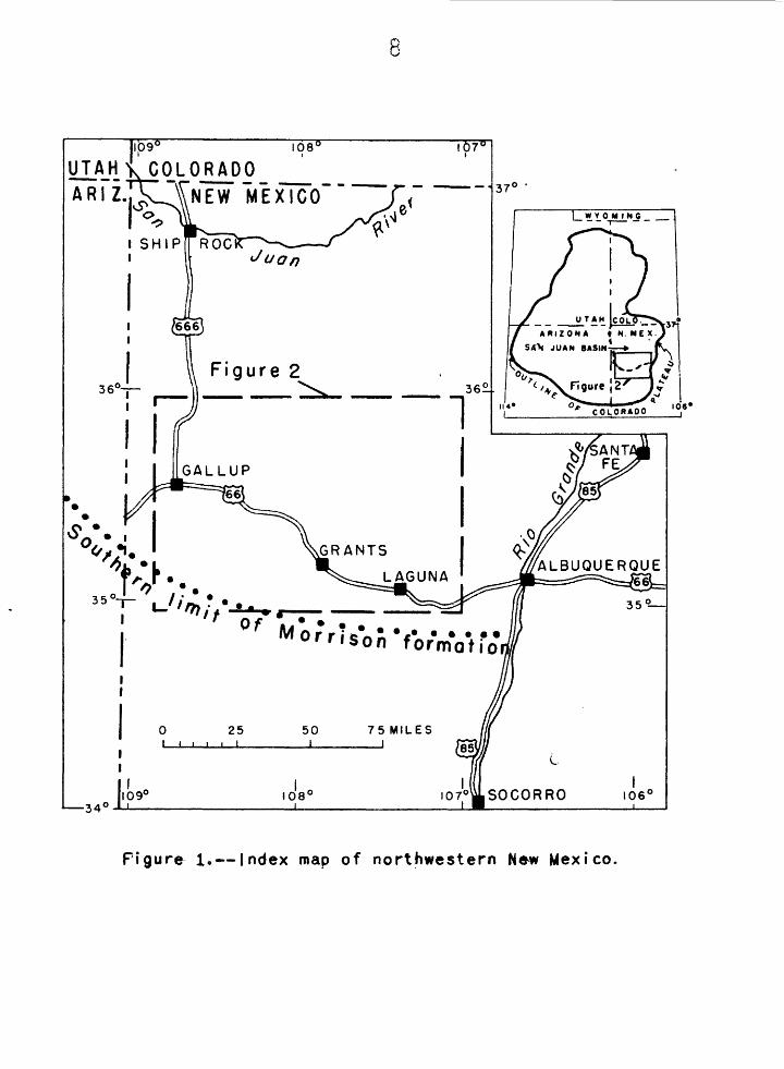
about 20 miles wide extending from Gallup to Laguaa, a distance of about
85 miles (fig. 1), The name "southern San Juan Basin mineral belt" Is
suggested for this area.
8
I06 *
UTAH1 COLORADO
NEW MEXICO
Figure 1.— Index map of northwestern New Mexico.

This paper "briefly summarizes the general geologic relations of
these deposits, speculates on the origin and localization of some indi
vidual deposits and the entire "belt, and attempts to appraise the*
chances for additional discoveries. Although some new evidence and
interpretations are presented, space does not permit a detailed description
of the deposits and the inclusion of all evidence to support the inter
pretations. This paper was originally prepared for publication in
the Proceedings of the United Nations 1 Second International Conference
on the Peaceful Uses of Atomic Energy, For lack of space the original
paper had to be drastically cut, leaving out much material that was
essential. The paper, essentially as originally written, is presented
here to give a more complete description of the geologic relations and
to reach those readers that might not have ready access to the
Proceedings of the Second International Conference.
This presentation is based largely on the results of areal and mine
mapping that was done in the Laguna district (fig. 2) by R. H. Mbench
and associates between July 1955 and May 1958, and on regional recon
naissance and specialized studies by L. S. Hilpert and associates
between July 195^ and May 1958.
GENERAL GEOLOGY
The San Juan Basin is a structural unit covering an area of about
15>000 square miles in northwestern New Mexico (fig. 1), Bocks exposed
along the southern margin consist of sedimentary strata ranging in age
from Permian to Cretaceous inclusive, and associated with intrusive and
extrusive rocks of Tertiary and Quaternary ages. The sedimentary rocks

generally dip northward at low angles toward the center of the basin,
but this regional attitude is modified locally by faults and minor folds.
STMTIGBAFBY
AH productive uranium deposits along the southern margin of the
San Juan Basin are in sedimentary rocks of Jurassic and Cretaceous age.
The lithologic characteristics and variations in thickness of these strata
and the stratigraphic distribution of the uranium deposits are summarized
in table 1. More detailed descriptions of the Todilto limestone r and the
Morrison formation, both of Jurassic age, are given below, for these
two formations contain most of the deposits in the region.
The Todilto limestone is gray and has a fetid odor when freshly
broken. Except where coarsely recrystal.11, zed, it is fine-grained and »
thinly bedded in the lower part and medium-grained and massive in the
upper part.
In the central and eastern parts of the southern San Joan Basin
mineral belt, where the Todilto limestone is ore-bearing (fig. 2), the
Todilto averages about 20 feet thick, but it ranges considerably in
thickness locally. In many places the limestone beds are conspicuously
deformed by folding and faulting; most of this deformation is entirely
within the formation, but in some places a few feet of beds above and
below the formational contacts are disturbed, thus causing abrupt though
small changes in the thickness of the formation. In the Laguna district
the Todilto is several feet thinner than average on the crests of broad
mnalI amplitude folds of Jurassic age and correspondingly thicker than
average in the troughs of these folds.

11
The Todilto limestone pinches out southward along a line about
12 miles south of Laguna and 15 to 20 miles south of Grants, and it pinches
out westward along a north-trending line several miles east of Gallup.
The formation is as much as 85 feet thick in the northern part of the
Laguna district, where the upper part of the formation is composed of
anhydrite and gypsum.
Except -where it is strongly deformed and recrystaHized, the
Todilto limestone in the Ambrosia Lake district can be separated into
three stratigraphie zones; from bottom to top these are commonly referred
to by the miners as the "platy," "crinkly," and "massive" zones. The
lower two zones are about equal in thiclmess and constitute about half
the total thickness of the formation. The "platy" and "crinkly" zones
consist of fine-grained, thin-bedded limestone with thin partings of
siltstone| black, dense, carbonaceous material is conspicuous locally
along the partings in the "crinkly" zone. The bedjSlng. in ;the "£laty"
zone is generally undisturbed, whereas, that in the "crinkly" zone is
intensely crenulated. The "massive" zone consists of more coarsely
crystalline limestone with indistinct bedding. In many places this zone
is a breccia of limestone fragments, mostly cemented by calcite. Locally
tihe top of the "massive" zone is a breccia, with fragments of limestone
embedded in sand derived from the overlying Summerville formation.
The upper part of this zone also contains lenses of siltstone, indi
cating a gradational contact with the Summerville. In the Laguna
district the part of the Todilto below the "massive" zone contains a
sequence of beds that have characteristics of both the "crinkly" and
"platy* zones, but are not separable into these two units as they are in
the Ambrosia Lake district,

12
Uranium deposits occur in aH three stratigraphic zones in the
Todilto. Probably most deposits are in the "platy" or "crinkly" zones,
but they may occur in any one or in any combination of the three zones.
The deposits are all, localized where the limestone beds are deforced by
folding and faulting, most of which is entirely intraformational.
The Morrison formation ranges from less than 100 to as much as
600 feet in thictoess in the area of the southern San Juan Basin mineral
belt. This formation extends over a broad region to the north, north*
west, and northeast of this area, but a short distance south of the area
the Morrison has been removed by pre-Dakota erosion. Here the Dakota
sandstone rests unconformably on progressively older beds south of the
mineral belt area*/
The Morrison comprises three members—the Recapture, Dfestwater
Canyon, and Brushy Basin members—that have partly ill-defined or
gradational contacts. The Recapture member is the lowest, and it con
sists dominantly of sandstone with some silty claystone beds. The sand
stone is fine- to medium-grained and forms alternating light-gray and
reddish-brown units 5 to 10 feet thick. !Ehe Recapture member is absent
locally in the Laguna district, but it is as much as 170 feet thick
elsewhere in the mineral belt area (fig. 3).
In some places along the southern margin of the San Juan Basin the
Westwater Canyon member—the middle unit of the Morrison formation—has
not been separated from the overlying Brushy Basin member except
arbitrarily. Both contain beds of similar lithologic types but in
different proportions. The Westwater Canyon member is composed dominantly
of light-colored fine- to coarse-grained arkosic sandstone, with some

13
Brushy Basin-type claystone. The Brushy Basin member is composed dominantly
of greenish-gray claystone, with some West-water Canyon-type sandstone*_ *
In this report the contact between these two members is arbitrarily
placed at the base of the lowest layer of Brushy Basin-type claystone
that is fairly thick and continuous. Where a layer of elaystone that
projects into Westwater Canyon-type sandstone pinches out, as shown on the
left side of figure 3, the contact of these two members is lowered or
raised to the base of another layer of Brushy Basin-type claystoae.
Thus the so-called "Poison Canyon" sandstone, which is of the Westwater
Canyon-type, lithologicaHy, is placed in the lower part of the Brushy
Basin member (fig. 3).
With this approach, the Westwater Canyon member is conceived as
thinning eastward from a thickness of 300 feet near Gallup to discon
tinuous lenses near Laguna. The Brushy Basin member, on the other hand,
ranges from 0 feet near Gallup to about 500 feet north of Laguna.
As presently used, the "Jackpile" sandstone, which is exposed only
in the Laguna district, is included in the Brushy Basin member. It
forms the uppermost part of the member, and ranges up to 190 feet in
thicioaess. According to J. S« Schlee (14, p. 1793 > a»& oral communi
cation) the "Jackpile" sandstone is e, fluvial "shoestring" sand
about 10 miles broad with distributary-like channels to the northeast.
The unit trends northeasterly across the Laguna district, and sedi
mentary structures indicate that these fluvial sands were transported
northeasterly, parallel to the length of the unit.

The important ore-bearing sandstones are generally in thick layers,
with crossbedding dominantly of the fluvial type, and they are inter
calated with relatively thin and discontinuous lenses of claystone* The
sandstones are mostly fine to medium-grained, but are locally conglomer
atic, and they are dominantly feldspathic. The Westwater Canyon-type
sandstones, and the lower parts of the "Jackpile" sandstone are cemented
by silica, calcite, and lesser amounts of clay, but the upper part of the
"Jackpile" sandstone is mostly clay-cemented. Fragments of fossil tree
trunks and limbs are also present in the sandstones; they are commonly
silicified, but some are coalified, A fine-grained black carbonaceous
material that is uranium-bearing is abundant in the uranium deposits; it
impregnates the sandstone, and probably was introduced after the sands
accumulated (see Deposits in clastic sediments)*
The sandstones of the Westwater Canyon and Brushy Basin members
except the "Jackpile," are typically yellowish gray to light grayish red,
but near ore deposits they have been altered to light gray. The "Jackpile"
sandstone, on the other hand, is dominantly light gray to nearly white;
its lighter color probably resulted from weathering before the overlying
Dakota sandstone was deposited. The "Jackpile" and other beds in the
upper part of the Brushy Basin were truncated by erosion before the
Dakota accumulated.
Electric log data from the few holes that have been drilled north of
the Ambrosia Lake district suggest that the sandstone of the Westwater
Canyon member there is more uniform in thickness and character, and
contains less mudstone than in the mining district* This difference may
indicate a northward change to more uniform conditions of sedimentation.
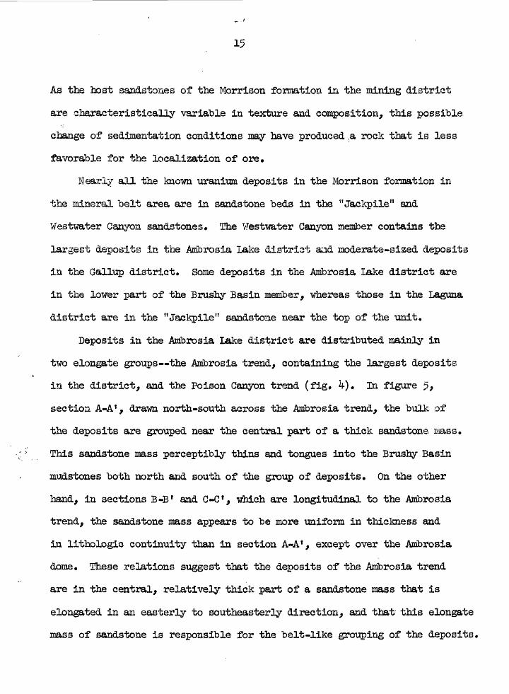
As the host sandstones of the Morrison formation in. the mining district
are characteristically variable in texture and composition, this possible
change of sedimentation conditions may have produced ,a rock that is less
favorable for the localization of ore.
Nearly all the known uranium deposits in the Morrison formation in
the mineral belt area are in sandstone beds in the "Jackpile" and
Westwater Canyon sandstones. The Westwater Canyon member contains the
largest deposits in the Ambrosia Lake district aad moderate-sized deposits
in the Gallup district* Some deposits in the Ambrosia Lake district are
in the lower part of the Brushy Basin member, whereas those in the Laguna
district are in the "Jackpile" sandstone near the top of the unit.
Deposits in the Ambrosia Lake district are distributed mainly in
two elongate groups—the Ambrosia trend, containing the largest deposits
in the district, and the Poison Canyon trend (fig. ^). In figure 5,
sectioa A-A f , drawn north-south across the Ambrosia trend, the bulk of
the deposits are grouped near the central part of a thick sandstone mass.
This sandstone mass perceptibly thins and tongues into the Brushy Basin
mudstones both north and south of the group of deposits. On the other
hand, in sections B-B 1 and C--C 1 , which are longitudinal to the Ambrosia
trend, the sandstone mass appears to be more uniform in thickness and
in lithologic continuity than in section A-A f , except over the Ambrosia
dome. These relations suggest that the deposits of the Ambrosia trend
are in the central, relatively thick part of a sandstone mass that is
elongated in an easterly to southeasterly direction, aad that this elongate
mass of sandstone is responsible for the belt-like grouping of the deposits.

So
uth
A
40
0r
Easte
rn
end
of
A
mb
rosia
d
om
e
.__
._..
-Ma
in
ore
-bear
ing
san
dsto
ne
mas
sD
AK
OT
A
se
cti
on
C
-C'
SA
ND
ST
ON
EB
end
Nort
h*i
A
1i
A
L^!^^
Cen
ter
of
No
rth
we
st
Af"b
rosi
a do
me
B410
0 te
So
uth
ea
st
B'
-W-4
00
IDA
KO
TA
S
_A
ND
ST
ON
E
*?' '
iipP
T;B
rusl
RilT
rgo Y
Tn71
ne n
jl je
7,J
lWjjj
^
-fp
^::
::ii:^
^W
esJ
wa
ter
Can
yon
m
em
ber
300
200
;00
Ben
dB
end
SA
ND
ST
ON
E„„,_.,,._ .I.,
.1T.
, .I ._
. .i.fuvn..j_
T,T
.,,.
,,.--
tw.
*%M
!*!l.
jjTtiw
!*rr
nt I'-'r''7'tir
TT7|'[]'!!H
ilf'T
]TrTr'l|!
i'jfl'
:!|!''
iM
s'ip
ilflij
i;!!:'
; • ^
;|j;,
<!:'M
;||!ii
iiJ^
!^H»
ilj?i
il!1'!
. ':"
;J Mi
'V
•' '
.'.
AiiP
- -;
.''"i
tiui
nrrr
__
ur
omun
dep
osits
st
wat
er
Cor
Won
m
embe
r
eca
ptu
f elH
Mm
te m
be
r
SC
ALE
cn
5.—
Geolo
gic
sections of
the M
orr
iso
n
form
atio
n
in
ttie
Am
bro
sJa
L.ak
e dis
tric
t sh
ow
ing
tl^e re
lations o
f th
e
M ra
nt u
rn d
ep
osits_
-tp
th
e str
ati g
rap
hic
units
5328
6 a
nd
to
th
e
Am
bro
sia
do
me;
p
ost-
Da
ko
ta T
oT
os
icm
ove
d ,
Likewise, the deposits of the Poison Caayon tread appear to "be localized
in the central part of an east-trending sandstone unit (7,8,2,3|
Mathewson, D. *E*,- .written" communication, 1953)«
In the Laguna district the deposits in the "Jackpile" sandstone
are not distributed in as clearly defined "belts, and the Jackpile
uranium deposit is elongated about at ri^ht angles to the dominant
northeasterly sediiaestary trends* The know deposits, however, are
grouped in a "broad sone aear the oaatral aod thickest parts of the
"Jackpile" sandstone.
STHJCTUML GEOLOGY
The sedimentary strata along the southern margin of the San Juan
Basin generally dip northward at low angles, "but they are broken by
faults, joints, and warped by gentle folds; and some units are deformed
locally by intraformational folds, faults, aad collapse structures*
Although some individual structural features cannot be dated with
complete confidence, three general periods of deformation are recog
nized since the accumulation of the Entrada sandstone, the oldest for
mation of Jurassic age in the area. The first period was during
Jurassic time, the second in the early to middle Tertiary, and the third
during middle to late Tertiary.. Only structures of the first period
show an obvious influence on the distribution and localization of the
uranium deposits.
The first period of deformation—during Jurassic time and possibly
extending into early Cretaceous time—produced two sets of folds and
probably the smaller structures that appear to be associated with them.

18
Figure 6 illustrates the distribution of these folds and smaller structures
in the Laguna district. Here one set of folds consists of "broad, gentle
warps that generally trend easterly, "but are sinuous. The largest of
these •warps is perhaps several miles wide, with an amplitude of a few
hundred feet. In the Laguna district this set of easterly trending
warps contains the largest folds of the Jurassic fold system and is
termed the major set, This set is essentially parallel to the northern
margin of a "broad highland that existed in central and southern
New Mexico in Jurassic time (13).
A similar set of folds probably also exists in the Ambrosia Lake
district. In figure 7> section D-D 1 , drawn north-south between the
Poison Canyon an$ Ambrosia trends (see figure 4), a set of broad foldss
is expressed by the sandstone and claystone layers of the Mbrrison
formation, which in turn is unconformably overlain by the Dakota sandstone*
In section E-E*, drawn east-west in the same area, the Dakota sandstone
appears to conformably overlie the Morrison formation, and no pre-Dakota
folds are apparent. Section E-E 1 , therefore, is essentially parallel to
a set of easterly-trending pre-Dakota folds, and section D-D 1 is normal
to this set of folds. In addition the sandstone and claystone layering
in the Morrison appears to be more uniform and continuous in an easterly
direction, parallel to the trend of the folds (section E-E 1 ) than in a
northerly direction (section D-D f )> a relation similar to that expressed
by the Westwater Canyon sandstone mass in the vicinity of the Ambrosia
trend.

19
The Ambrosia dome (fig. k-) is a prominent structure that involves
the Dakota and younger rocks, and is, therefore, in part a younger structure*
In figure 5, section B-B f , however, the Westwater Canyon member thins v
markedly over the crest of the dome, and is relatively thick around the
entire periphery of the dome. It is doubtful that the thinning of
the Westwater Canyoa member over the dome resulted from differential
compaction because the Brushy Basin claystone shows no similar thinning
over the crest of the dome. It seems more likely, therefore, that the
dome was a positive or relatively higft domal feature in Morrison times,
receiving less sand over its crest than around its periphery.
The second set of Jurassic folds is well developed in the Laguna
district (fig. 6). Most are about a half a mile across, with amplitudes
of as much as 100 feet, and they trend persistently N.10°-30 W. They
are much smaller than the largest folds of tlifr aa'sterly-trending set and
are termed the minor t set of the Jurassic fold system. For lack of
exposure the intersections between folds of this set and the easterly-
trending set were not seen, but both sets of folds may occur in the
same areas.
03ae bedding of the Todilto limestone is contorted in many places in
the area. Where strongly disturbed, the beds are folded into a great
variety of shapes—as open and closed, anticlines, fan folds, recumbent
folds, and chevron folds, most of which are asymmetric. Although parts
of the folds are fractured, and some folds are cut by small low-angle
thrust faults, the characteristics of plastic deformation are dominant.
The amplitude of these structures is about equal to, or somewhat less than,
their breadth, which ranges from less than an inch to about 30 feet.

20
Although, some of the largest folds involve "beds in the top few feet of
the underlying Eatrada sandstone and basal beds of the overlying
Summerville formation, most of the folds are confined to the Todlltoi
limestone* At least in the Laguna district these folds in the Todiltoi
limestone are localized mainly along the flanks and troughs of the
broad east-trending and north-trending folds, and their dominant trends
are likewise eastward and northward, as indicated by the rose compass
diagram in figure 6. Northward and eastward are also the dominant trends
of the folds in the Todilto limestone in the Ambrosia district, but their\
relations to the broad pre-Dakota folds has not been determined. As the
Todilto limestone in the Laguna district is somewhat thicker in the
troughs of the broad folds than on the crests, these data combined
suggest that the intraformational folds developed by flowage of poorly
consolidated muds down the limbs of the broad folds* This flowage
occurred under some sedimentary cover in post-Todilto time because none
of the folds is truncated by bedding planes.
Peculiar collapse structures are common in the Morrison formation
and in the Bluff and Summerville formations in the area. They are
circular in plan and vertical in orientation, and they range from 1 inch
to 200 feet in diameter and from 1 foot to 300 feet high. Locally they
are called "sandstone pipes" or "breccia pipes," One of the several
hundred pipes found in the area is known to contain uranium ore, that
at the Woodrow mine (see figure Ik and section titled the Woodrow deposit).
Subsequent to the preparation of this report the pipe that Is exposed in
the Jackpile mine has been found to be mineralized to some extent (see
figures 8 and 9),

21
Typically the pipes are bounded by a ring fault, or by several
concentric ring faults and the beds surrounding the pipes are commonly
inwardly downwarped (figs. 8, 9, and Ik). The material at any point in
a pipe consists of the same material that forms the wall rock a short
distance above, but it has been largely disaggregated and shows little or
no bedding or other sedimentary structure. The pipe-filling material
is compact and without .voids other than the pores of the rock. The pipes
flare upward and are covered by undisturbed beds. Downward, though their
bases are rarely seen, they likewise pass into undisturbed beds.
Typical ly the pipes terminate at their tops in sandstone, and extend down
ward into mudstone or silt stone. The pipes are largely confined to two
stratigraphic units—the Morrison formation, and the lower part of the
Bluff sandstone downward into the SummerviHe formation. Hone is known
to penetrate the Todilto limestone or the Dakota sandstone. Their
general stratigraphic range, therefore, is about 1,000 feet,
The tops of some pipes are well exposed and provide a basis for
determining their time of origin, Figure 8 is a section through the top
of a pipe in the "Jackpile" sandstone. The general characteristics of-
this pipe are similar to those described above, but in particular it
illustrates the upward flafre of the top, and the fact that it both cuts
and is overlain by "Jackpile" sandstone. In addition this pipe contains
abundant and diverse types of vfragmental carbonaceous material, whereas ;
the waU rocks are essentially barren of carbonaceous material. The
authors interpret that this pipe formed disring the deposition of the
"Jackpile" sandstone, and was buried by additional "Jackpile" sandstone.
It probably formed rapidly, sucking into it much plant debris from its
immediate surroundings at the surface* The plant debris probably was

22
thus buried and preserved, whereas, in the wall rocks it was not. Other
pipes reveal unconformable relations "between the downwarped sandstone at
their tops and the overlying -undisturbed sandstone, Indicating that they
formed at the time of sedimentation of the units that contain them*
From the observations made so far, no satisfactory interpretation
can be offered to explain the origin of these collapse features. They
evidently formed during the accumulation of the highest beds they cut,
and before complete compaction and consolidation of the beds containing
them* Most of the pipes in the Laguna district are localized in long
narrow belts that closely parallel the Jurassic folds of both sets (fig. 6),
suggesting that this deformation influenced the collapse in some way.
The Jurassic foCLds of both the easterly- and northerly-trending sets
formed prior to the deposition of the Dakota sandstone, and possibly
contemporaneously with the deposition of the Jurassic rocks above the
Entrada sandstone. Folded rocks in both the Laguna and Ambrosia Lake•i j
districts are truncated in many places by the overlying Dakota sandstone,
demonstrating the pre-Dakota age of the folds* As the sandstone pipes
originated during the deposition of the Summerville, $luff and Morrison
rocks, and are commonly localized in belts that closely parallel the
folds, it is likely that the folds developed in part at the same time.
In addition, as the intraformational folds in the Todilto limestone
probably resulted from flowage of poorly consolidated lime down the
flanks of the broad folds, it is likely that the broad folds developed
in part not long after Todilto deposition.

23
If the Jurassic folds developed contemporaneously with the deposition
of the Jurassic rocks, more likely than not the folds influenced the
deposition and distribution of these rocks. The sandstones of the
Morrison formation In both Laguna and Ambrosia Lake districts are
interpreted to have "been thus influenced. The "Jackpile" sandstone,
in the shape of a "shoestring" sand, rougfrly parallels the major
easterly-trending set of Jurassic folds; the data on cross-lamination
suggest that the sands were transported in the same direction (fig* 6)*
In addition, the thickness of the Morrison formation "beneath the
"Jackpile" sandstone increases by as much as 150 feet from the margin of
the "shoestring" to its center. It is possible, therefore, that in tjie
vicinity of the "shoestring" sand the Morrison formation occupies a broad
northeast-trending warp that formed contemporaneously with the deposition
of the Morrison, and that the stream that deposited the "Jackpile" sand
stone was controlled by this warp.
In the Ambrosia Lake district pre-Dakota folding may have likewise
influenced the deposition of the Mortison formation. It has been noted
previously that the sandstone and mudstone layering are most continuous
and uniform in thickness in an easterly direction, which is essentially
parallel to the elongation of the sandstone host of the Ambrosia trend.
It has also been noted that at least one set of pre-Dakota folds in this
district has an easterly axial trend. It is possible, therefore, that
broad gentle folding during Morrison time tended to localize into easterly
courses the streams that deposited the sandstones.

The second period of deformation was in early to middle Tertiary
time. Uplift again occurred in the area of the Zuni Mountains and sub
sidence in the area of the San Juan Basin defined this structure. The
movements tilted the beds into low-angle northerly to northeasterly dips
west of the Mount Taylor area and northerly to northwesterly dips on the
east side. The McCartys syncline, which marks the change in these domi
nant dip directions, also formed at this time, as well as the faults 1 and
folds near the eastern end of. the Zuni uplift. The Ambrosia dome, which
probably started to form before the Dakota formation was deposited, be
came well defined. The faulted monocline that marks the western boundary
of the Rio Grande trough (fig. 2) may also have formed at this time.
The third period of deformation took place during middle to late
Tertiary, and possibly into Quaternary times, when the Colorado Plateau
province was uplifted regionally and the Rio Grande trough subsided.
In the region of the southern San Juan Basin mineral belt this defor
mation was characterized dominant ly by fracturing. To a limited extent
fracturing took place during the two earlier deformations, but as
middle to late Tertiary was the time of greatest differential movement
between the Rio Grande trough and the Colorado Plateau, this was probably
the time of most intense fracturing in the mining districts. The joint
and fault system in the Laguna district is similar to that on the
western edge of the Rio Grande trough, and the late Tertiary and
Quaternary igneous rocks are fractured by the same system.

25
Although some geologists believe that the fractures of post-Dakota
age influenced the localization of the uranium deposits'along the southern
margin of the San Juaa Basis—and certainly these fractures had some
influence on the distribution of secondary minerals—the writers believe
that these structures formed later than the primary mineralization.
Where post-Dakota f&ults intersect ore deposits they cut and displace the
ore. Some fractures carry ore minerals of uranium and vanadium, but
only where the fractures cut ore deposits, and where such deposits show
obvious effects of oxidation. Porthermore, where the distribution and
trend of deposits show a suggested parallelism or association to fracture
systems, the occurrences invariably seem to be above the present water
table where there has certainly been some oxidation and redistribution
of uranium;
RELATIONS OF URANIUM DEPOSITS TO IGNEOUS BOCKS
Igneous activity has been intense in the eastern part of the Gallttp-
Lagqna area from late Tertiary to Recent times. It probably began with
the intrusion of diabasic sills and dikes, followed by the formation of
Mount Taylor, a large stratified volcano, and closely followed by sporadic
outpouring of basaltic lava from a great many pipes and fissure vents in
the immediate vicinity of Mount Taylor.
Diabasic sills and dikes east of Mount Taylor interconnect and
probably were intruded contemporaneously, though this intrusion is not
accurately dated. The dikes dominantly follow the prominent north-
trending fracture set, and the sills, in turn, are jointed and locally
faulted by the same set. This suggests that the diabase was intruded
contemporaneously with fracturing that formed mostly in middle to

-26
late Tertiary time. Inclusions of the diabase were found in a volcanic
pipe that probably supplied one of the earliest basaltic flows, indicating
that the diabasic rocks are at least older than what may be the oldest
basaltic flows. These basaltic flows were ertruded essentially contem
poraneously with the latest stages of the Mount Taylor eruptions.
Because the entire Mbmrb Taylor sequence probably formed over a short
period of time, the authors suspect that the diabasic intrusions took
place before both the basaltic and Monat Taylor extrusions.
The volcanic rocks of Mount Taylor consist dominafctly of pyroclastics
and flows of rhyolite, trachyte, and latite, and also dikes of prophyritic
andesite (9). The basaltic flows, pipes, and fissure vents in the immedi
ate vicinity are composed dominantly of olivine basalt, but include some
rocks of intermediate composition. Both the MDunt Taylor stratovolcano
and the oldest basaltic flows rest on an erosion surface that is probably
younger than the major structural developments in the Mo Grande trough.
The oldest basaltic flows are probably overlain by some of the pyro
clastics from Mount Taylor, and overlying basaltic flows intertongue
with an alluvial cone built out from the upper part of Mount Taylor; these
relations suggest little, if any, break in time between the Mount Taylor
eruptions and the extrusion of the basaltic flows. Younger basaltic flows
rest on younger erosion surfaces, and some flows follow the present
drainage.
The distribution pattern of the known deposits in the entire mineral
belt area does not suggest a spatial relationship to the igneous rocks
(fig. 2). Furthermore, the diabasic dikes and sills, probably the
oldest igneous rocks, intrude and displace many uranium deposits in the

Laguna distriet (fig. 11 aad IT) and metamorphose them along the contacts.
As these rocks are yotmger than the deposits, it is unlikely that they
influenced the localization or origin of them.
URAmjM DEPOSITS
The uranium deposits along the southern margin of the San Juan Basin
group themselves into three types—those in sandstones and associated
mudstoaes of the Entrada, Mozrlsoia, aad Dakota formations| those in the
Todilto limestonej aad one deposit in a pipelike structure. The deposits
in the clastic sediments are similar to most of the -uranium deposits in
other parts of the Colorado Plateau region in type and habit of ore and
accessory minerals, in the tabular form of ore bodies, and in their
association 'with some form of carbonaceous material. The deposits in
limestone have a somewhat similar mineral assemblage to the other deposits
in the region but are essentially unique in the type of host rock and
their preference for structurally deformed beds. The pipelike deposit
is truly unique in the area, thought similar in some respects to the
deposit in the collapse structure at Temple Mountain, Utah, and perhaps
a few other occurrences in down-faulted rocks.
In spite of the differences in stratigraphic position aad the
lithologic and structural environments of the deposits in the southern
part of the San Juan Basin, the writers believe that they aH belong to
the same general class and had a common origin. The geologic relations
that are a basis for this idea, and certain other geologic relations
that will \be .described, ̂ pe±mity the .eoussfcpt: of-& jnlneacai belt .alMg .the
southedmargitrof;.the^Saa

Mtoeralogy
!Ehe ore minerals are domiaaatly fine-graiaed, and they mainly occupy
pore spaces in the host rock^ t>ut also partly replace it. These minerals
consist of low-valeat uranium and vanadium minerals and their oxidized
products. F&te-grained carbonaceous material is abundantly and intimately
associated with the ore minerals in some and perhaps all the deposits.
Other accessory minerals consist of fine-grained sulfides in all deposits
and fluorite ia some. The uranium in many of the deposits is in part or
largely in the hemvalent state, especially in those deposits that are
above the present water table. It is assumed that this hexavalent ••
uranium formed by oxidation of minerals containing tetravalent uranium.
The occurrence of only the unoxidized ore minerals and the carbonaceous
material will be described in detail..
Ore minerals
Coffinite is a uranium silicate with the approximate formula of
U(SiOK)1-x(OE)ij.x (17), It is black, moderately hard, moderately heavy,
and can be distinguished from uraninite only by its X-ray pattern. In the
southern San Juan Basin area it is apparently the principal uranium
mineral in uaoxidized ores in sandstone. Typically it is extremely fine
grained and intimately associated with the carbonaceous material, mostly
occupying pore spaces but partly replacing the sand grains. In the
Woodrow deposit (see below), on the other hand, some coarse-grained
coffinite that is apparently free from carbonaceous material has "been
found. It partly replaces massive pyrite and marcasite but is also
veined by marcasite.
29
Uraninite (11)2) is the common -uranium mineral in the unoxidized
deposits in the Todilto limestone. It is typically fine-grained. It
mainly impregnates and replaces the limestone, in part as fine inter-
growths with fluorite and a vanadium-bearing silicate (11, 12). It is
also localized along siltstoae laminae "between bedding planes in the
limestone, Uraninite has "been recognized in a deposit in the Entrada
sandstone, where it occurs as thin films on sand grains, in veinlets in
a vanadium-bearing silicate, and at* small concretions Borrouoded by
pyrite.
As the vanadium content of the deposits in the southern San Juan
Basin area is low, averaging about 0,15 percent VoOc, vanadium minerals
are not conspicuous. Most of the low-valent vanadium in these deposits,
however, occurs as a fine-grained micaceous mineral and is presumed to
be one or more varieties of the vanadium-bearing silicates—mica, chlorite,
or clay—that are common in the vanadium-bearing uranium deposits in
other parts of the Colorado Plateau region. This material mainly occupies
the pore spaces of the rock or replaces argillaceous material and detrital
quartz and feldspar. Baggite and paramontroseite, both vanadium oxides,
have also been reported as mineral occurrences,
Tyuyamunite /pa( UOg) 2( VO^) 2 * 7 -10 • 51*297 and camotite
/K^UOg) 2(^01^* 3^227 are ^° common secondary uranium minerals where
vanadium is available. Other common secondary uranium minerals are also
present in places. These minerals mostly occur in open spaces, either
pores or fractures.

Carbonaceous material
The sandstones containing most of the deposits in the southern
San Juan Basin area are light-colored "but the ore is various shades of
gray. Three suites of samples from the Jackpile and Windwhip deposits,
totaling 21 samples, reveal a close correlation betweea blackness-'
and organic carbon content* The darker the rocks the higher the
organic carbon content. Very light-gray-' isoek, typical of barren host
sandstone, contains 0.0^ to 0*08 percent organic carbonj and the darkest
sample—medium dark-gray to dark-gray-'—reveals 2.16 percent organic
carbon (Wayne Mount joy, analyst). A suite of 52 samples from the
Jackpile mine gave the following average assays: ligiht-gray samples
0.0^ percent UoOgj medium-gray samples, 0.31 percent UoOgj and dark-gray
samples, 0,^1 percent U^OQ. As the organic carbon occupies much more
volume than the equivalent weight percent of uranium and is at least as
abundant by weight as uranium in these samples, the gray color of the
samples and the ore is probably imparted by the carbonaceous material.
X-ray studies of the ore in sandstone show that much of the uranium
is in the form of finely divided coffinite that is dispersed through the
carbonaceous material. This carbonaceous material is apparently
ubiquitous within the deposits, so its distribution reflects the gross form
of the deposits. Most of it occurs as coatings on sand grains and
intergranuLar fillings. Locally it is massive and partly replaces the
J Bock-color chart, 1951* Geological Society of America

31
detrital grains, Where coarse enough to separate mechanically from the
rock it is a black brittle substaaee with a submetallic luster and a
specific gravity of about 2,
Accessory minerals
Pyrite and xnarcasite are the common accessory minerals in aH deposits,
but they are generally sparse. These minerals mostly form minute crystals,
irregular patches, or small nodules in t?ae sandstone, partly replacing •'--
the sand grains. In the Woodrow deposit, on the other hand, pyrite and
marcasite are much more abundant and form small incomplete replacement
masses and locally boxwork structures controlled by the intersections of
bedding and fracture planes in breccia fragments.
Trace amounts of fine-grained chalcopyrite, galena, and sphalerite
are also present in many deposits.
Fine-grained fluorite, partly iatergrowi with uraninite, occurs as
disseminated specks and in small irregularly shaped masses, in places in
deposits ifl, the Todilto limestone.
Deposits in clastic sediments
The uranium deposits in clastic sediments have yielded most of the
ore produced and contain most of the known ore reserves in the southern
San Juan Basin mineral belt. Most of the deposits are in sandstone lenses
in the MDrrison formation3 a few are in the Entrada sandstone and a few
are in sandstone and carbonaceous shale of the Dakota sandstone* The
deposits in the Dakota have been described by Gabelman (5, p» ^22-^295
6, p. 303-63.9) and will not be discussed here.

32
The ore-bearing sandstones are fine* to coarse-grained, they are
composed dominantly of quarts but contain various amounts of feldspars
and other minerals common in sandstone as well as clay particles and thin
mudstone layers. The ore and associated minerals including the fine-
graine'd carbonaceous material, impregnate the sandstone, mostly
occupying pore spaces but also partly replacing the sand grains. The
ore bodies mostly occur as tabular layers that lie essentially parallel
to the major bedding but which in detail transect bedding. These bodies
are irregular in plan but tend to be elongate parallel to the trends of
sandstone lenses, other sedimentary structures, and the two sets of
pre-Dakota folds. They may be as much as several thousand feet in
length and 50 feet or more thick. Small masses only a few feet across
may be tabular or irregular in shape and roughly equidimensional.
Carbonized or silicified plant fossils are present in the Morrison
formation in the southern Sail Juan Basin, but unlike many uranium
deposits in other parts of the Colorado Plateau region, these fossils are
not particularly abundant in the ore-bear ing sandstone, and they are not
conspicuously more abundant in the mineralized rock than in the surround
ing barren sandstone. The plant fossils in the ore are commonly richly
mineralized; but such materials a few feet above the ore are commonly
barren of uranium. The possibility that this plant material influenced
the localization of the deposits seems less likely in northwestern
New Mexico than in other parts of the Plateau region.

33
On the other hand, many ore deposits and possibly all of the
larger ore deposits contain much uranium-bearing orgtaic carbon in the
form of a black fine-grained material that is disseminated through the
sandstone and coats and partly replaces the sand grains* The distri-»
bution of this material is apparently reflected by the gross form of the
uranium deposits. Because the deposits assume a variety of forms that
cut across sandstone bedding and crossbedding, as show* la, figures 10,
12, and 13, it is assumed that the organic carbon was introduced into the
sandstone in a fluid form. As the deposits composed of this material are
commonly suspended at some level above the base and below the top of the
sandstone, as shown in figures 9 and 13, it was probably introduced under
some kind of water-table or fluid interface condition. The rather close
association of this carbonaceous material and the uranium it contains
suggests they were introduced at the same time.
Deposits in limestone
The Todllto limestone is fine- to medium-grained, but where it has
been deformed, it is partly recrystallized and ccazse-grained* The ore
minerals and the associated sulfides and fluorite are dominantly fine
grained, and they occur as replacements disseminated in the rock and
along minor fractures and bedding planes. The ore bodies are localized
where the limestone has been deformed by intraformational folding and
faulting. Some ore bodies are irregular in shape but most are elongate
and range from 20 to 30 feet in width and from 100 to a few thousand
feet in length. Although most of the ore is in the lower part of the
Todilto limestone, it may occur throughout the formation, and thus

34-
the ore bodies range in thickness from a few feet to as much as 20 feet
or more. In a few places the ore bodies extend into the top few feet of
the underlying Entrada sandstone or a few feet into the overlying
Summerville formation.
The Todilto limestone is dark-colored, has a fetid odor, .and contains
as much as 1 percent or slightly more organic carbon. Some carbonaceous
material is obviously concentrated as a dense black substance along
parting planes in the thinly bedded parts of the formation, but some of
it probably is disseminated throughout the rock. It is not obviously
more abundant in or near ore than in the barren rock away from deposits.
Analyses of the mill-pulp samples from 23 deposits showed a range from
0.05 to 0.1^ percent organic carbon in the ores (Wayne Mountjoy, analyst).
No data are available on the adjacent barren host rocks. More infor
mation is needed regarding the nature and distribution of this carbon
aceous material and its possible influence on the localization of
uranium minerals.
The deposit in a sandstone pipe
As only one deposit in a sandstone pipe, that at the Woodrow mine,
has been observed in northwestern New Mexico, the description of it will
be deferred to the section of this report where individual mines are
described (see below).

35
Relations of the deposits to structural features
Sedimentary structures in sandstone, intraformational folds and
faults in the Todilto; limestone, pipelike collapse structures in sand
stone and mudstone, and tectonic folds formed by regional deformation all
influenced the localization of the uranium deposits. As far as the
writers can determine, the only tectonic structures, however, that have
directly or indirectly controlled the deposits are those that are related
to the Jurassic, or first system of deformation.
Many ore deposits in the Morrison formation are in or near the central
thick parts of sandstone lenses, and they tend to be elongate parallel
to the trend of these lenses, suggesting that these parts of the lenses
offered channelways for the ore-bearing solutions and favorable loci for
ore deposition. Although such features as bedding planes, mudstone
layers, cross-laminae, and grain-size variations within small sedimentation
units show concentrating effects within deposits, sedimentary structures
alone have localized only a few deposits. Commonly deposits transect
sedimentation units within the host rocks, and the group of deposits that
forms the Sandy mine area crosses the Todilto limestone-Entrada sandstone
contact (see fig. 15). Likewise, many of the minor forms assumed by the
ore within deposits sharply transect the sedimentary structures.
As all deposits in the Todilto limestone are associated with intra
formational folds and faults, these structures apparently controlled the
deposits. Likewise, the Woodrow—the only deposit in a sandstone pipe-—
was obviously localized by the structure it occupies. Although the top
and bottom of the Woodrow pipe, the only pipe definitely known to be ore-
bearing, are not visible, there is no definite evidence that this pipe

36
or any of the others are connected with any other vertical structure
that might have formed a through-going ehannelway for ascending or
descending solutions. Thus, even though the Woodrow pipe certainly
localized its deposit., its function may have been that of a locus of ore
deposition rather than a channelway for solutions.
The folds resulting from regional deformation of Jurassic age
probably caused and localized intraformational flowage of beds in the
Todilto limestone and perhaps triggered the slumping in the sandstone
pipes, and they may also have had some controlling influence on the
position and direction of flow of the streams that deposited the ore-
bearing sandstone lenses in the Morrison formation. If true, these
folds had an indirect influence on the localization of the uranium deposits.
With regard to later deformation, on the other hand, the writers have
found no positive evidence that the positions or trends of deposits arei
in any way related to folding or fracturing. Furthermore, all through-i
going faults observed appear to have displaced the deposits. Although
in places enrichment has occurred along regional faults and fractures within
deposits, secondary concentration, of relatively recent age, seems to
have been the more likely cause.
Localization and origin
The writers can offer only general suggestions regarding the local
ization and origin of the uranium deposits in the southern San Juan Basin
mineral belt area., Although the three types of deposits certainly were
localized by different controls, the writers favor the idea of a common
origin. The deposits in the Morrison formation are in the central parts

37
of sandstone lenses, form tabular layers that commonly transect bedding
at low angles, and consist of an intimate mixture of ore minerals and
carbonaceous material. An organic solution moving along the beds under
water-table or fluid interface conditions conceivably could form deposits
of this character if some local influence caused precipitation of constitu
ents in solution. The same or a similar solution moving along the Todilto
limestone and adjacent beds might have found conditions favorable for
uranium precipitation in the limestone where it was deformed and partly
recrystallized. In a somewhat similar manner the Wbodrow pipe could have
served as a barrier to precipitate uranium from passing solutions. No
definite evidence as to the source of the ore-bearing solution or the
metals contained is recognized. The deposits certainly formed after
Jurassic deformation, probably after the Dakota sandstone was deposited,
and before pronounced deformation in Tertiary time.
The Jackpile and satellitic deposits
The Jackpile uranium deposit, in the Laguna district, is probably
the largest single deposit in the United States, and is one of the world's
great producers of uranium. It constitutes about one-third of the total
known uranium ore reserves in New Mexico, but its average grade is
probably somewhat less than the average for all New Mexico uranium ores.
The deposit is mined by a H^rge-scale open-pit operation. The initial
discovery was made in 1951"by airborne radiometric survey, and subsequent
drilling proved a moderate-sized deposit, now known as the South ore body.
In 1953> a larger ore body, now called the North ore body, was found a
short distance to the north; this body supplies almost all the current
production from the mine.
The Jackpile and associated deposits are in the "Jackpile" sand-*
stone. The North ore body, which is the largest, consists of at least
two large tabular ore layers (fig. 9). It is about 1,300 feet wide,
several thousand feet long, and both layers total as much as 50 feet
thick—probably averaging about 20 feet thick. It is elongated about
N. 10° W. In additon a number of much smaller tabular deposits, as the
Windwhip and the South ore body of the Jackpile mine, are satellitic to
the North ore body.
The two ore layers of the North ore body are figuratively suspended
about midway between the top and bottom of the "Jackpile" sandstone.
These layers lie essentially parallel to the major bedding of the sand
stone, (as shown in the longitudinal section, figure 9)> though apparently
they transect the bedding to some extent, as suggested in the cross
section, figure 9> and certainly the top of the upper layer locally
transects the crossbedding units, as shown in figure 3.0. The cross-
cutting relations shown in"* figure 9 are typical, though the upper boundary
of ore is not typically a flat surface, and locally the edge of ore will
follow bedding planes or thin discontinuous mudstone beds.
In contrast the grade variations within the deposit are strongly con
trolled by a multitude of sedimentary features. Clay galls, mudstone
beds, and bedding planes commonly show concentrating effects, and large
pods of high-grade ore commonly conform with trough cross-stratification.
In addition, very sparse intraformational faults and joints show some
concentrating effect.
In the mine area the Cretaceous rocks dip gently about N. 20 W.,
with local flattening and steepening, and the North ore body appears to
conform with the structural dip.

39
4 —
Cross bedded-sandstone
Datum is approximate mean sea level
FEET
- 6
-4
-2
-0Geology by R.H Moench
1956
EXPLANATION
[HI |Ore rods
Mineralized sandstone
FIGURE 10-- FIELD SKETCH SHOWING RELATION OF TOP OF JACKP1LE URANIUM DEPOSIT TO CROSSBEDDING IN SANDSTONE

The long dimension of the North ore body may parallel the axis of a
pre-Dakota anticline. In figure 9* cross section, this anticline is
defined by two mudstone beds within the "Jackpile" sandstone. The -upper
most mudstone bed, in the vicinity of the sandstone pipe, rises a short
distance towards the center of the section, and is truncated by the base
of the Dakota sandstone. The lower mudstone bed rises to $ crest just
west of the center of the deposit, and then falls a short distance and
pinches out on the west flank of the anticline. For lack of sufficient
exposure the breadth, amplitude, and trend of the anticline are not known.
Other folds nearby, however, are well exposed and trend N. 10° ¥. As this
is a persistent regional trend of one set of pre-Dakota folds, it is likelyo
that the fold exposed in the Jackpile mine also trends N. 10 W. and co-
extends with the long dimension of the North ore body.
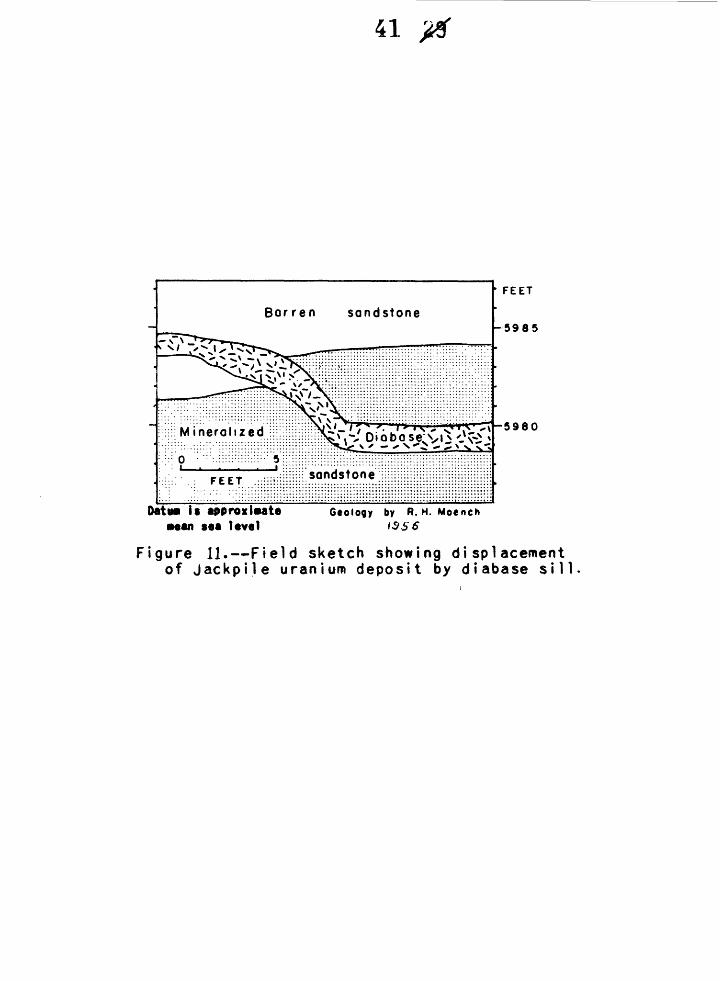
An extremely irregular complex diabase sill cuts much of the Jackpile•*
deposit. This sill is related to the late Tertiary diabase dikes and sills
that are abundant throughout the Laguna district. It averages several
feet thick and is essentially horizontal, but cuts randomly through the
deposit—locally rising well above or falling well below it. In figure 11
the sill is shown to cut through the top of the deposit. Here, the
deposit is displaced by an amount equivalent to the thickness of the sill., .
indicating that the sill was emplaced later than the uranium deposit.
A sandstone pipe is exposed on the east side of the North ore body
(fig. 9)» Tne top of thi's pipe is shown in figure 8 and is described
above in connection with sandstone pipes. Only the upper part of the pipe
is exposed, the top of which is about ho feet above the top of the ore
body. Although organic materials are abundant within the pipe, they
41 '
• FEET
-5985
^T-5980
Da tun it approximate ••an sea lavaI
Otology by R. H. Moench 6••an aaa level i3£6
Figure 11.—Field sketch showing displacement of Jackpile uranium deposit by diabase sil
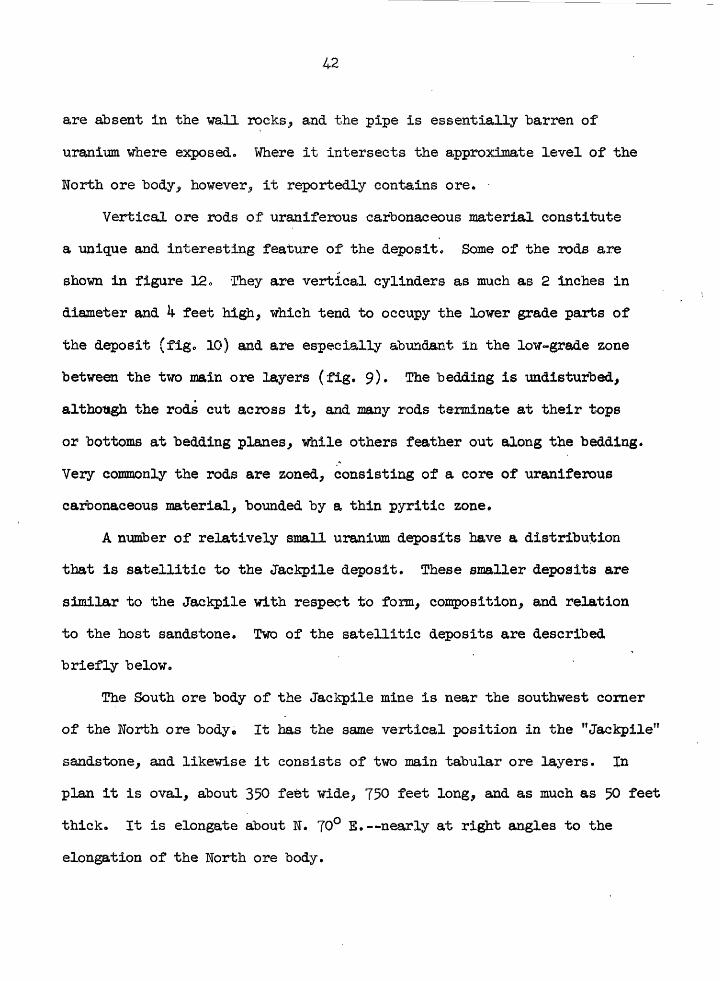
are absent in the waU rocks, and the pipe is essentially barren of
uranium where exposed. Where it intersects the approximate level of the
North ore body, however, it reportedly contains ore.
Vertical ore rods of uraniferous carbonaceous material constitute
a unique and interesting feature of the deposit* Some of the rods are
shown in figure 12. rhey are vertical cylinders as much as 2 inches in
diameter and k feet high, which tend to occupy the lower grade parts of
the deposit (fig* 10) and are especially abundant in the low-grade zone
between the two main ore layers (fig. 9)» The bedding is undisturbed,
although the rods cut across it, and many rods terminate at their tops
or bottoms at bedding planes, while others feather out along the bedding.
Very commonly the rods are zoned, consisting of a core of uraniferous
carbonaceous material, bounded by a thin pyritic zone.
A number of relatively small uranium deposits have a distribution
that is satellitic to the Jackpile deposit. These smaller deposits are
similar to the Jackpile with respect to form, composition, and relation
to the host sandstone. Two of the satellitic deposits are described
briefly below.
The South ore body of the Jackpile mine is near the southwest corner
of the North ore bodyo It has the same vertical position in the "Jackpile'1
sandstone, and likewise it consists of two main tabular ore layers. In
plan it is oval, about 350 feet wide, 750 feet long, and as much as 50 feet
thick. It is elongate about N. 70° E.—nearly at right angles to the
elongation of the North ore body.

Figure 12.—Photograph of vertical ore rods, Jackpile mine.
S3286

The Windwhip deposit is on the west side of the Jackpile deposit.
Its horizontal dimensions are not known to the writers.? Tout it is con
siderably smaller than the South ore body. The Windwhip deposit is sus
pended within the "Jackpile" sandstone, but is stratigraphically higher
than the Jackpile deposit. It is about 15 feet below the top of the
"Jackpile" sandstone } and probably overlaps the western edge of the
Jackpile deposit.
The general character and distribution of ore in the Windwhip deposit
is illustrated in figure 13. Here the ore conforms locally to the sedi
mentary structures, or transects such structures at a low angle. In many
places, however, the ore has a smoothly curved edge that cuts sharply
across the bedding. Such features are similar to the roll structures
described by Fischer (k) and Shawe (15, 16) in other parts of the Colorado
Plateau.
The Poison Canyon and associated deposits
The Poison Canyon deposit is in the Ambrosia Lake district. It is4
one of the few large deposits in the district that is sufficiently devel
oped to allow effective study. The general mineralogy and configuration
of this deposit have been described by Dodd (2, 3)- Dodd's description,
combined with the results of more recent work are summarized below. The
deposit illustrates a more direct relation to sedimentary features than
has been observed in deposits of the Laguna district.r
The Poison Canyon deposit is in the "Poison Canyon" sandstone of
the Morrison formation. It is a tabular deposit consisting of many sub-
parallel layers. Individual layers are as much as 200 feet wide and
20 feet thick, and they form an aggregate as much as TOO feet wide

be
nd
in
se
ctio
nF
EE
T
59
90
HN.
48°
E.
Dakota
sandsto
ne
N.
82°
E
5985-
5980-
59
75
-
"Jack
pi le
" sa
nd
st
one
of
the
M
orr
ison
form
atio
n
__
Gro
ss
be
dd
ed
s
an
ds
ton
e
h: > \
5970-
5965-
RO
LL
ST
RU
CT
UR
E
con
cave
sid
e
EX
PLA
NA
TIO
N
102
0
FE
ET
CO
NG
LOM
ER
ATE
Da
tum
is
as
sum
ed
MIN
ERAL
IZED
RO
CK;
SOLI
D
BLAC
K W
HERE
HI
GHE
ST
GRA
DE;
STIP
PLED
W
HERE
LO
WER
GR
ADE
Gro
un
d
I ine
~--.
Ge
olo
gy
by
R
.H.
Mo
ench
FIGURE *2r. — GEOLOGIC WALL MAP OF THE
WINDWHIP DEPOSIT.
J9
53286

and. 35 feet thick. The layers and the aggregate are all strongly elongated
in an easterly direction. The deposit is near the base of the host sand
stone, and concentrations are most abundant above or below thin mudstone
beds. Dodd (2, 3) states that the deposit is elongate along the trend
of sedimentary structures, and is localized in the central thick coarse
grained part of the unit. He illustrates (2, fig. 8) that the Poison
Canyon deposit and also the Mesa Top deposit, immediately to the east of
it, are in, and coextensive with, a "composite" channel in the "Poison
Canyon" sandstone, Recent work bears out these relations, and subsurface
information reveals that the "composite" channel extends eastward in a
broad arc at least 7 miles long (fig. ^). It is referred to here as the
Poison Canyon trend.
The deposit is cut by a number of northward-trending faults, and
all available evidence suggests that the faults are younger than the
deposit. The ore layers are displaced by the same amount of throw as the
units in the host rock. Dodd (2, 3) states that the grade and thickness
of the ore increases adjacent to the faults, but also states that only
secondary minerals are found on fault and fracture surfaces. More recent
work has revealed that the higher grade concentrations adjacent to the
faults are made up of minerals containing hexavalent uranium. The deposit
is most oxidized near the faults, and it is probable that these concen
trations formed by near-surface redistribution of uranium by ground water.

The uranium deposits north of the Poison Canyon deposit
North of the Poison Canyon deposit the uranium deposits of the
Ambrosia Lake district constitute several multi-million-ton and numerous
smaller deposits that account for more than one-half of the total uranium
reserves in the southern part of the San Juan Basin. Unfortunately they
have not been developed sufficiently to study in detail. With respect
to form, composition, and structural and stratigraphic relations, however,
they are known to be similar to the other deposits in the Morrison formation.
For lack of detailed information, the deposits of this area are described
collectively.
As shown by their approximate outlines in figure ^, the deposits in
this area, the Ambrosia trend, constitute an elongate easterly-trending
group that is essentially parallel to the Poison Canyon trend. The approx
imate vertical distribution of the deposits within the Morrison formation
is shown in figure 5« Individual deposits are essentially tabular and
are figuratively suspended within the host sandstones (fig. 5) similar to
the deposits in the Morrison and Entrada formations of the Laguna district.
In general the deposits occur where the sandstones are coarsest and,
locally, occur in one or more zones having an aggregate thickness of as much
as 100 feet. In general, however, the deposits have average thicknesses
that range from several feet to several tens of feet. Like the Jackpile
deposit, they generally follow the bedding, but locally transect sedi
mentary units (see just right of the center of section C-C 1 , fig. 5)»
Most of the deposits, including all those that contain more than
about 1 million tons of material, are in tne Westwater Canyon member;
the others are in the Brushy Basin member. As pointed out above in the

section on stratigraphy, most of the deposits are near the central part
of a thick mass of sandstone (see fig. 5)> which is more extensive and
uniform in an easterly direction than a northerly direction, except where
it thins markedly over the Ambrosia dome.
The authors interpret that the "belt of deposits in this part of the
Ambrosia Lake district is coextensive with and controlled "by the easterly
trend of the thicker part of the sandstone mass. Absence of uranium
deposits over the crest of the Ambrosia dome and the .tendency to clustering
of deposits around its periphery are probably related to the thinning of
the host sandstone mass over, the dome rather than to closure on the dome.
The Woodrow deposit
The Woodrow deposit, about 1 mile east of the Jackpile mine, is
unique in the district, and probably on the Colorado Plateau. It is
small, but exceedingly higih grade, the ore averaging nearly 2 percent
uranium. It is particularly interesting, however, because it occupies a
structure that may best be termed a sandstone pipe. The pipe (fig. 14)
is nearly vertical, has a known height of about 230 feet, and a maximum
diameter of about 35 feet. It is bounded by a complex branching ring
fault. The wall rocks include the "Jackpile" sandstone, and underlying
beds of mudstone and sandstone. With the exception of probable down- ,
warping and faulting in the near vicinity of the pipe, these rocks are
essentially undeformed. The core of the pipe is made up of a hetero
geneous mixture of sandstone and mudstone which appears to have been derived
from the nearby wall rocks. Near the top of the pipe sandstone predom
inates; near the bottom mudstone predominates. The transition zone is

EXPLANATION^ground surface
ORE (high grade)
ORE (low grade)
SANDSTONE
MUDSTONE
60
FEET
Geology by R H Moench
— 0
Figure Ifc—Diagrammatic section through the Woo draw pipe.
53206

about 35 feet "below the "base of the "Jackpile" sandstone, and probably
indicates the amount of downward displacement of the core with respect
to the wall rocks. Carbonaceous materials are abundant within the pipe,
and a few fossil bone fragments have been found*
In the upper part of the pipe the ore is exceptionally high grade,
and is concentrated mainly along the boundary ring fault. Here the
core of the pipe is essentially barren, but the ore locally extends
several feet outward into the "Jackpile" sandstone. In the lower part
of the pipe the ore is much lower grade, though still higher grade than
the district average, and is more or. less homogeneously distributed
throughout the core.
The ore concentration along the ring fau}.t is a replacement, not a
fissure filling. Massive sulfides, as pyrite .and marcasite, commonly
show relict bedding, in which the outlines of individual grains are
visible. High-grade coffinite-sulfide mixtures locally show boxwork
textures, controlled by bedding-fracture intersections.
As the top of the Woodrow pipe has been eroded and its bottom has
not been found,, its original stratigraphic range, age, and origin cannot
be determined. That part of the. pipe which is well exposed, however, is
strikingly similar to the many hundreds of sandstone pipes that are ex
posed throughout the Laguna district (see structural geology). Although
the Woodrow pipe is mineralized, the writers interpret that it is the
same type of structure as the others. If so, the ring fault acted as a
locus of uranium deposition, rather than as a conduit.
51
The Sandy mine
The Sandy mine, which is in the Laguna district, is in an area about
2,000 feet wide by lj-,000 feet long, referred to here as the Sandy mine
area. It contains many small, locally high-grade deposits, including the
Sandy, which occur in the Entrada sandstone and Todilto limestone. Little
uranium ore has been produced from the area, but it is discussed to il
lustrate (l) the occurrence of uranium deposits in the Entrada sandstone
and Todilto limestone, (2) the relation of deposits in the respective
host rocks to one another and to a pre-Dakota monocline, and (3) the
relation of the deposits to the diabasic sills and dikes.
The area is underlain by the Summerville formation, Todilto limestone,
and Entrada sandstone. Late Tertiary diabase dikes, 1 to 5 feet thick,
and a great many diabase sills, as much as 75 feet thick, cut and have
metamorpnosed-/ to some extent all of these rocks and many of the
J- The metamorphism of the rocks and ores will be treated in a
forthcoming report.
uranium deposits.
The dominant structure in the area ;Ls a monocline that is related
to the major easterly trending set of pre-Dakota folds. The monocline
trends easterly to northeasterly across the area. Its:steep flank dips
southward, is about 1,300 feet broad, and its maximum structural relief
in the mine area is about 110 feet,
The Todilto limestone in the area contairis a multitide of intra-
formational folds. These are small but pronounced structures, with
'amplitudes about equal to their breadths. The largest folds have a

52
"breadth of a"bout 20 feet, and involve the entire thickness of limestone.
The smallest are less than half an inch broad and commonly have the relation
of drag to the larger folds. In sections the folds have a variety of shapes,
the most common of which is that of an asymmetric fan. The axes of the
intraformational folds on the flanks and near the anticlinal bend of the
monocline mostly parallel the larger structure, but near the synclinal
bend they are highly sinuous and are not systematically oriented.
The known uranium deposits of the area constitute a group of deposits
that are confined to the steep flank and anticlinal and synclinal beds
of the monocline. Figure 15 illustrates the relation of the group of
deposits to the monocline and to the two host rocks. To better illustrate
these relations the diabasic dikes and sills have been removed from the
section, and the structure restored to its pre-diabase position. This
was done because the diabase is younger than the uranium deposits and
distorts the earlier structure. Near the anticlinal bend of the monocline
most of the deposits are within the Entrada sandstone. A few very small
deposits are on the formational boundary, but none is in the Todilto
limestone. Near the synclinal bend the deposits are all within the
stratigraphically higher Todilto limestone. Also, downdip some deposits /
pass from Entrada sandstone into Todilto limestone. The relief on the
group of deposits, therefore, is less than the relief on the monocline,
and the group transects the formational boundary.
Figure 16 illustrates the essential physical features of a typical
deposit in the Entrada sandstone. The deposit is tabular—about twice as%
long as it is wide. It is suspended within its host sandstone—not
bounded by any visible sedimentary or structural feature. In addition

53
Todilto limestone.
<O.OI pet. U
Entrada sandstone Floor of pit Entrada sandstoneGeology by R H Moench
5 0 2O FEET
Datum is approximate mean seo level
Figure«.--Section through uranium deposit in Entroda sandstone, Sandy mine.
53284
it shows roll structures, as do many of the small deposits in sandstone.
The axes of these structures parallel the average strike of crossbedding.
The deposits in the Todilto limestone are almost wholly associated
with intraformational limestone folds. The deposits, therefore, are
stringlike ajid highly sinuous in plan. Figure 17 illustrates in section
the distribution of ''iranium with respect to the central part of a lime
stone fold. The uranium deposit, as indicated, by the one-tenth and
higher milliroentgen isorad., is dominant ly in the imssive thick-bedded
limestone, which is in the center and at the base of the fold. In
section the form of the deposit is crudely that of a reversed L, and it
is coextensive with the fold.
The deposit is separated into three parts by two diabasic sills,
which are younger than the deposit. As the lower sill is about 20 feet
thick, the lowermost part of the deposit is not shown in figure 16. The
upper sill cuts the top of the deposit, and truncates all isoracte higher
than 0.05 milliroentgens. The 0.05 milliroentgen isorad reflects only
an increase in general radioactivity toward the deposit. The highest
grade parts of the deposit, and the major limestone units above the sill
are all displaced to the right with respect to the same features below
the sill. The lower sill cuts the base of the deposit. As this part of
the deposit is the basal part of the reversed L, the higher grade isorads
spread out at the base of the sill as well as at the top.

W2»
8M6
5*24
5922
EXPLANATlOW
Umestune
Limestone massive,thick bedded
Dtobose
Arogonite
Coor$« colcifa
_ I Q _ ^
Iso rod lineradioactivity in
mttttro*ntgM» p»r ft our;haettur»t point ia 4 friction
of A/fAtr radioactivity
Figur* I7,~ Section across urgnium deposit in Tod i I to limestone, Sandy mine orea.
53286

56
The F-33 mine
The F-33 deposit, in the Ambrosia Lake district (fig. 2), is an
excellent example of an average-sized uranium deposit in the Todilto lime
stone. It is discussed here to illustrate the distribution of the deposit
with respect to the lithologic units in the limestone, and to minor folds.
The Todilto limestone in this mine contains the lower "pla;ty," medial
"crinkly," and upper "massive" units that persist throughout most of the
region (see Stratigraphy). These rocks are strongly deformed, and they
define a number of folds and faulted folds (fig. 18). In contrast with
much of the folding in the Todilto limestone the largest fold exposed in
this mine involves the upper part of the Entrada sandstone. The best-
developed fold in the F-33 mine is an anticline that has a breadth in
excess of 50 feet and a maximum height of about 7 feet. The northern
flank of the anticline is steeper than the southern flank and is locally
overturned and thrusted (fig. 18). This structure, as well as the smaller
linear structures in the mine, is oriented, with some variation, about
N. 70° E.
The uranium deposit is contained within all three units of the
Todilto limestone (fig. 18). Although most of the ore is in the "crinkly"
and "massive" zones, there appears to be little direct relation between
lithologic changes and distribution of the uranium deposit.
The deposit and the fold are closely coextensive. The deposit as
a whole is about 100 feet wide, as much as 15 feet thick, and more than
1,200 feet long. Its long dimension, oriented about N. 70 E., is
closely coextensive with the fold. Although the width of the deposit

57
is much greater than the breadth of the anticline, its highest grade parts
are mostly in the structural low just north of the steep or overturned
flank (fig. 18).
RESOURCES IN UimPLOKED GROUND
The ore-bearing rocks between Gallup and Laguna dip northward, so,
generally speaking, there is only one line of outcrop of these formations
(fig. 2), The known deposits have been found at this outcrop or, by
subsurface exploration, at moderately shallow depths within a few miles
north of this outcrop• It is possible that the pattern or frequency of
distribution of these deposits at and near the outcrop continues in these
formations northward under increasing depth of burial toward the center
of the San Juan Basin; under these circumstances the undiscovered resources
would be extremely large. On the basis of interpretations from known
geologic relations, however, it seems more likely that the deposits will
tend to be clustered in a zone at least 20 miles wide behind the present
outcrop; this idea permits the concept of the southern San Juan Basin
mineral belt. Even though this concept restricts the favorable ground
geographically, the amount of unexplored ground within the limits of this
belt is enough to contain several times as much uranium resources as is
now known. The gologic evidence and reasoning for this belt are reviewed
below.
A short distance south of the Gallup-Laguna area the Morrison for
mation is cut out by the unconformity that underlies the Dakota sandstone.
Although deposition of the Morrison undoubtedly extended a short distance
to the south of this line, the existence of a broad area of nondeposition

in central and southern New Mexico (13) suggests that the southern limit
of deposition of the Morrison was not far south of its present southern
limit (fig. 1).
The Todilto limestone also pinches out in a depositions! edge along
a line a short distance south of Laguna and east of Gallup, and still
farther south the Entrada is cut out by pre-Dakota erosion. The Gallup-
Laguna area seems to have been close to the southern edge of the general
basin of deposition in which the Jurassic rocks of the Colorado Plateau
region accumulated. Perhaps the tectonic movements that during the
Jurassic formed and sustained this basin caused the minor flexures in
the Gallup-Laguna area. These flexures probably gave rise to the intra-
formational folds in the Todilto limestone, preparing the ro6k for later
ore deposition; and these flexures may also have had some control on the
positions and trends of the streams that formed the sandstone lenses
which are hosts for the deposits in the Morrison formation. At any rate,
because of these marginal relations, rocks favorable for ore deposits did
not extend much farther south than the present line of outcrop between
Gallup and Laguna.
Evidence to limit and predict the northern edge of this conceived
belt is even more tenuous, for the ore-bearing rocks are buried. Of
course, the pre-Dakota flexuring could have extended northward into the
basin of Jurassic deposition, but it is more likely that this deformation
was concentrated along, and perhaps restricted to, the basin margin.
In the Laguna district the "Jackpile" sandstone thins northward from the
Jackpile mine; and no significant uranium deposits are known more than a
few miles north of the Jackpile mine. There has been little exploration
north of the known deposits in the Ambrosia Lake and Gallup districts

59
because of the increasing depth of burial of the ore-bearing rocks. There
is some evidence, however, that the ore-bearing sandstones locally thin
northward from the vicinity of the deposits in the Ambrosia Lake district.
Where the sandstones show no apparent thinning they become more uniform
in character. This greater uniformity of the sandstones suggests a
depositional change basinward, possibly to quieter, or more uniform
fluvial conditions, and the deposition of sedijaents that were probably
unfavorable for the formation of significant uranium deposits.
In summary, the reasons for the existence of this "belt of known
uranium deposits are not fully known; the fact remains, however, that the
belt parallels a number of controlling end definitive geologic feainarea.
In addition to the Jurassic highland and the southern limits of the Todilto
limestone and the Morrison formation, it parallels the easterly trend
of the major Jurassic folds, the dominant orientation of the intraformational
folds in the Todilto limestone, the elongation of the thickest parts of
the host sandstones of the Morrison formation, the dominant known sedimen
tary trends within these host sandstones, and, finally, it parallels the
individual belts of deposits, as the Poison Canyon and Ambrosia trends.
The southern San Juan Basin mineral belt can therefore be defined as a
geologic feature that is controlled by a combination of several geologic
structures and events.
SUMMART MD CONCLUSIONS
Uranium deposits along the southern margin of the San Juan Basin
occur in the Morrison, Todilto, and Entrada formations of Jurassic age
and the Dakota sandstone of Cretaceous age. The known reserves have a

60
total value of more than one "billion dollars; most of these reserves are
in the Morrison formation.
In the Morrison formation the ore minerals of the principal deposits
are intimately mixed with a carbonaceous material that impregnates sand
stone and forms tabular bodies that lie nearly parallel to the bedding.
Most deposits are in the central parts of thick sandstone lenses. Gentle
folding during Jurassic time may have controlled the positions of the
streams that formed these sandstone lenses.
The ore minerals in the Todilto limestone impregnate and replace the
limestone where it has been deformed by intraformational folding and
faulting. This deformation may have been caused by the flowage of uncon-
solidated lime muds on the flanks of the Jurassic flexures, for the intra
formational folds are localized along these flexures and many are elongate
parallel to them. Typically the ore bodies in the Todilto are long but
narrow.
Sandstone pipes are numerous in the eastern part of the area and also
are localized along the flanks of these Jurassic flexures. Their positions
and their habits suggest that they resulted from some slumping action
before consolidation of the beds they cut. Only one of the several
hundred pipes known has yielded uranium ore, and only one other reportedly
contains ore. It is likely that these pipes provided loci for deposition
of uranium, rather than channelways for ascending or descending uranium-
bearing solutions.
Deformation during Jurassic time may have had some direct or indirect
influence on the localization of the uranium deposits in the rocks of
Jurassic age; there is no definite evidence that later tectonic structures

61
had a genetic influence on the deposits. Although the genesis of the
deposits is not known, it is believed that all of them had a common
origin. It is suggested that solutions circulating through the rocks
under water»table conditions could have formed deposits that would have
habits like those in this area.
ACKNOWLEDGMENTS
The field work was greatly aided by the cooperation of the mining
companies in permitting access to their properties and file data. Although
the list of companies and individuals is too long to credit here, their
help is gratefully acknowledged. Richard P. Fischer deserves much credit
for his help in reviewing the manuscript. The writers also appreciate
the assistance given by colleagues in the Grand Junction Operations Office,
U. S. Atomic Energy Commission.
The work was done by the U. S. Geological Survey on behalf of the
Division of Raw Materials of the U. S. Atomic Energy Commission.
62
REFERENCES
1. Dane, C. E., and Bachman, G. 0., 1957* Preliminary geologic.map of
the northwestern part of New Mexico? U. S. Geol. Survey Misc.
Geol. Inv. Map 1-224.
2. Dodd, P. H., 1956a, Some examples of uranium deposits in the Upper
Jurassic Morrison formation on the Colorado Plateau, in
Proceedings of the International Conference on Peaceful Uses of
Atomic Energy, Geneva, Switzerland,? 1955: United-Nations,
v. 6, p. 615-633.
3. _______, 1956b, Examples of uranium deposits in the Upper Jurassic
Morrison formation of the Colorado Plateau, in Page, L. R.,
Stocking, H. E«, and Smith, H* B., Contributions to the geology
of uranium and thorium "by the United States Geological Survey
and Atomic Energy Commission for the United Nations International
Conference on Peaceful Uses of Atomic Energy, Geneva, Switzerland,
1955: U. S. Geol. Survey Prof. Paper 300, p. 2*6-262.
4. Fischer, R. P., 19^2, Vanadium deposits of Colorado and Utah, a pre
liminary report: U. S. Geol. Survey Bull. 936-P, p.-363-39^•
5. Gabelman, J. ¥., 1956a, Uranium deposits in paludal "black shales of
the Dakota formation, San Juan Basin, New Mexico, in Proceedings
of the International Conference on Peaceful Uses of Atomic Energy,
Geneva, Switzerland, 1955: United Nations, v. 6, p. ^22-^29.
6. ______, 1956b, Uranium deposits in paludal black shales, Dakota
sandstone, San Juan Basin, New Mexico: U. S. Geol. Survey Prof*.
Paper 300, p. 303-319*

63
7« Hilpert, L. S», and Freeman., V, L., 1956a, Guides to -uranium deposits
in the Gallup-Laguna area, New Mexico, in Proceedings of the
International Conference on Peaceful Uses of Atomic Energy,
Geneva, Switzerland, 1955: United Nations, v, 6, p. 3^-3^9.
8. _______, 1956b, Guides to uranium deposits in the Morrison for
mation, Gallup-Laguna area, New Mexico: U. S. Geol. Survey
Prof. Paper 300, p. 299-302.
9» Hunt, C. B,, 1938> Igneous geology and structure of the Mount Taylor
volcanic field, New Mexico; U. S. Geol. Survey Prof. Paper
189-B, p. 51-80.
10. ______, 1956, Cenozoic geology of the Colorado Plateau: U. S.
Geol. Survey Prof. Paper 279.
11. Laverty, R. A., and Gross, E. B., 1956a, Paragenetic studies of
uranium deposits of the Colorado Plateau, in Proceedings of the
International Conference on Peaceful Uses of Atomic Energy,
Geneva, Switzerland, 1955: United Nations, v. 6, p. 533-539.
12. _______, 1956b, Paragenetic studies of uranium deposits of the
Coloratio Plateau: U. S. Geol. Survey Prof. Paper 300, p. 195-201.
13. McKee, ,E* D», and others, 1956, Paleotectonic maps of the Jurassic
system: U. S. Geol. Survey Misc. Geol. Inv. Map 1-175*
14. Schlee, J. S., 1957, Petrology of the "Jackpile" sandstone (aTos.):
Geol. Soc. America Bull., v. 63, p. 1793•
15. Shawe, D. R., 1956a, Significance of roll ore "bodies in genesis of
uranium-vanadium deposits on the Colorado Plateau, in
Proceedings of the International Conference on Peaceful Uses of
Atomic Energy, Geneva, Switzerland, 1955: United Nations,
v. 6, p. 335-337.
16. ______, 1956b, Significance of roll ore "bodies in genesis of
uranium-vanadium deposits on the Colorado Plateau: U. S. Geol.
Survey Prof. Paper 300, p. 239-2^1.
17. Stieff, L. R., Stern, T. W., and Sherwood, A. M., 1956, Coffinite, a
uranous silicate with hydroxyl substitution: a new mineral:
Am. Mineralogist, v. ^1, p. 675-688.