cgts2015 sebele rep - nuleaf planning and environmental
TRANSCRIPT

Proposed Sebele Lodge Development Remainder of the farm Sebele 931 KP
Geohydrological Study
DATE: December 2015 REVISION Final REFERENCE: 20150811/CGTS/Lvdw COMPILED FOR: Loxvita (Pty) Ltd.COMPILED BY: CGTS
CGTS
REMAINDER OF THE FARM SEBELE 931 KP - GEOHYDROLOGICAL STUDY Page ii
Table of Contents 1. INTRODUCTION ..................................................................................................................... 1 1.1. Background .............................................................................................................................. 1 1.2. Terms of Reference ................................................................................................................. 2 1.3. Proposed groundwater use ...................................................................................................... 3 1.4. Storage Capacity ..................................................................................................................... 3 1.5. Sanitation ................................................................................................................................. 4 1.6. Solid waste .............................................................................................................................. 4 2. REVIEW OF THE PHYSICAL ENVIRONMENT ....................................................................... 5 2.1. Geographical Setting ............................................................................................................... 5 2.2. Climate and Rainfall ................................................................................................................. 9 2.3. Morphology, Soil & Vegetation ................................................................................................. 9 2.4. Land use ................................................................................................................................ 10 2.5. Local setting .......................................................................................................................... 10 3. GEOLOGY ............................................................................................................................. 12 3.1. Regional Geology .................................................................................................................. 12 3.2. Local Geology ........................................................................................................................ 12 3.3. Geotechnical Investigation ..................................................................................................... 13 4. REGIONAL HYDROGEOLOGY ............................................................................................. 14 5. LOCAL HYDROGEOLOGY ................................................................................................... 16 5.1. Lateral extent of groundwater zone ........................................................................................ 16 5.2. Hydro-census ......................................................................................................................... 19 5.3. Commissioning of additional water supply boreholes ............................................................. 23 5.3.1. Geophysical Survey ............................................................................................................... 23 5.3.2. Borehole Drilling ..................................................................................................................... 23 5.4. Aquifer yielding potential ........................................................................................................ 23 5.4.1. Aquifer testing ........................................................................................................................ 24 5.5. Depth to water table and hydrostatic fluctuations ................................................................... 27 5.5.1. Depth to water table distribution ............................................................................................. 27 5.5.2. Hydrostatic fluctuations .......................................................................................................... 27 5.5.3. Groundwater flow directions ................................................................................................... 27 5.6. Groundwater Use ................................................................................................................... 28 5.7. Hydro-chemistry ..................................................................................................................... 28 5.7.1. Hydro-chemical Imaging ........................................................................................................ 29 6. RESOURCE DIRECTED MEASURES................................................................................... 34 6.1. Preliminary Classification of Groundwater Resource ............................................................. 34 6.2. Reserve Determination and Water Balance ........................................................................... 35 6.3. Preliminary Groundwater Resource Quality Objectives .......................................................... 36 6.3.1 Groundwater Quantity ............................................................................................................ 36 6.3.2 Groundwater Quality .............................................................................................................. 36 6.4. Proposed Future Management Class ..................................................................................... 37 7. RISK ASSESSMENT ............................................................................................................. 38 7.1. Significance Assessment Methodology .................................................................................. 38 7.2. Assessments of Impacts ........................................................................................................ 39 8. CONCLUSIONS ..................................................................................................................... 51 9. RECOMMENDATIONS .......................................................................................................... 54 9.1. Mitigation Measures ............................................................................................................... 54 9.2. Environmental Monitoring Programme ................................................................................... 54 References ........................................................................................................................................ 58 APPENDIX I: HYDRO-CENSUS PHOTOGRAPHIC RECORD APPENDIX II: GEOPHYSICAL SURVEY REPORT APPENDIX III: BOREHOLE CONSTRUCTION & GEOLOGICAL LOG REPORTS APPENDIX IV: PUMPING TEST REPORTS APPENDIX V: HYDRO-CHEMISTRY LABORATORY CERTIFICATES
CGTS
REMAINDER OF THE FARM SEBELE 931 KP - GEOHYDROLOGICAL STUDY Page iii
Executive summary Loxvita (Pty) Ltd appointed Core Groundwater Technical Services on the 12th of August 2015 to conduct a geohydrological study incorporating a groundwater reserve determination and water balance calculations that would support a Section 21 Water Use License Application as per ANNEXURE B - REQUIREMENTS FOR WATER USE LICENCE APPLICATION: GROUNDWATER ABSTRACTION [S 21 (a)], should it be required, for the proposed Sebele Lodge Development on the Remainder of the farm Sebele 931 KP. The 4,014ha Sebele property is straddled by the water divide between quaternary catchment areas A32C and A32D with the portion across the latter consisting of two Resource Units (RU) of which one (the Northern Dolomite Outcrop) can possible be further divided due to compartmentalization. In both Quaternary Catchment areas A32C and A32D, the conditional abstraction of groundwater is permitted under a “General Authorisation” up to a maximum of 45m³/hectare/annum. As far as the property in question is concerned this figure translates to 495m3/day (61.8m3/d – A32C & 433.2m3/day A32D). The total maximum water demand determined for the proposed Sebele development is 76.920m3/day or 28,075.800m3/annum The initial regional assessment of the water demand on the different portions of the 4,014ha property as they pertain to the identified groundwater reserves all calculate to Category A or small scale abstractions (<60% of recharge on the individual parts of the property). The water demand is to be met from groundwater through one existing borehole, SBH-2; and two newly commissioned boreholes, namely SBH-4 and SBH-5. The combined sustainable safe yield of the three (3) aquifer tested boreholes calculates to 80.194m3/day, meeting the demand with 3.274m3/day spare capacity. Preliminary groundwater reserve determinations, recharge plus groundwater inflow into the area and the amount allowed to be intercepted from outflow, less existing groundwater abstraction, including basic human need (BHN), the Ecology and IFR requirement as well as the groundwater outflow from the area, are all indicative of substantial extra possible groundwater allocations. Although the regionally indicated groundwater component of river baseflow (mean annual flow) is indicated as negligible, a conservative 35% of recharge (conservative 1%) was awarded to the respective ecological reserves. Although peak occupancy can be expected over certain times of the year the average annual occupancy levels should / will probably be in the region of 70%. As far as back up provision and overall water security is concerned, large track of land remains unexplored allowing not only suitable spacing of potential additional / future production boreholes but also ample capacity in terms of availability under “General Authorizations’”, the significant extra groundwater allocations possible from the identified groundwater reserves (even after provision for the proposed Sebele development), as well as what is left of the indicated Average Groundwater Harvest Potential (lower range) as pertaining to the different portions of the property as they related to the mentioned reserves. Two geophysical drill sites pertaining to the identified Pretoria Group Resource Unit (A32C) groundwater reserve remain unexplored. Although the water is chemically generally of an excellent quality (mostly within the SANS 241-1:2015 chemical numerical limits), nitrate enrichment is apparent in some of the samples. The observed bacterial presence in the water makes continuously disinfection advisable. Routine water quality monitoring is also imperative.
All three of the identified Sebele groundwater reserves / flow regimes were afforded a “C” present status category and “Fair +” water resource class. A “C” Desired Category Status with a proposed “Fair” Management Class was afforded all three groundwater reserves. Preliminary Groundwater Resource Quality Objectives include quantity objectives recommending the drawdown at the proposed abstraction points not to exceed the determined critical drawdown for these points, as well as a preliminary groundwater quality reserves that entails the ambient groundwater quality values being compared with the SANS 241-1:2015 Standard Limits, with the lesser values being escalated by 10%; and the monitoring of these objectives. None of the current or proposed Sebele activities assessed indicated “no-go” implications and in conclusion it can be stated that should the listed mitigation measures, Desired Category Status and Management Class be adhered to and maintained, the risk that the proposed Sebele operation will pose to humans and the environment is regarded as low. The proposed monitoring system design which is supported by a well-informed set of resource quality objectives should serve as sufficiently early implementation of corrective/preventative measures or where necessary, the setting of new objectives.

CGTS
REMAINDER OF THE FARM SEBELE 931 KP – GEOHYDROLOGICAL STUDY Page 1
1. INTRODUCTION The farm Sebele (4,014ha) was acquired by the Barokologadi Community Property Association (BCPA) in terms of the Restitution of Lands Rights Act, 22 of 1994 and transferred into the name of the BCPA (CPA/2007/0984/A) in July 2007 (title deed T64698/2009).
The property is situated approximately 83km (as the crow flies) north-east of Zeerust, 1km west of the Molatedi Village and adjacent south east of the Madikwe Game Reserve. The Molatedi dam basically fronts the southern boundary of the property. Direct access to the property is obtained from gravel district road D1010. This district road via the Molatedi village links up with a tarred road to the R565 west of Pilansberg.
An application in terms of the National Environmental Management Act (NEMA) was submitted early 2014 for the renovation of the 4 old dilapidated chalets as well as 6 additional chalets at Lotteringskop (in the north western section of the farm) and is in the process of being finalised.
The BCPA has approached the group – Elephants, Rhinos and People (ERP) – that has as its main aim to address rural poverty by providing communities with direct economic benefit that they will derive from protecting the wild life on their restituted land as well as where they live adjacent to game parks.
ERP has also partnered with the PEACE Foundation that has as a model the coordination, facilitation and funding of strategies and projects to alleviate poverty in rural communities through the promotion of local economic development.
The BCPA, ERP and the PEACE Foundation have identified a strategy to develop tourist accommodation on the Sebele Farm that will unlock the potential of the land, facilitate economic development and create many job opportunities for the surrounding communities.
The concept envisaged for Sebele is tourist accommodation in the form of a lodge or a combination of up to six smaller lodges with a total 110 beds that will be situated at one or at a maximum of 6 localities as indicated on the Sebele Site Plan 1 (Figure 1.1). The configuration of the tourist accommodation in the form of 16, 24, 32 or 110 bed lodges will be determined during detail planning. Traversing of guests accommodated in the lodges will be mainly on the 4,014ha of Sebele. Negotiations are also underway between the BCPA and North-West Parks and Tourism Board (NWPTB) to incorporate the 4,014ha Sebele farm into the Madikwe Game Reserve. If this materializes a link between the Madikwe Game Reserve, the Molatedi Dam and 12km of the Marico River will be created. The existing infrastructure (roads, boreholes) will be utilized and will only be supplemented where necessary to be sufficient to serve the proposed development.
1.1. Background Loxvita appointed Core Groundwater Technical Services on the 12th of August 2015 to conduct a geohydrological study incorporating a groundwater reserve determination and water balance calculations that would support a Section 21 Water Use License Application as per ANNEXURE B - REQUIREMENTS FOR WATER USE LICENCE APPLICATION: GROUNDWATER ABSTRACTION [S 21 (a)], should it be required, for the proposed Sebele Lodge Development on the Remainder of the farm Sebele 931 KP. The 4,014ha property is straddled by the water divide between quaternary catchment areas A32C and A32D with the portion across the latter consisting of two Resource Units of which one can possible be further divided due to compartmentalization. The National Water Resource Strategy 2 (2013) indicates that allocations from the Molatedi Dam total 23Mm3/annum, yet only 15Mm3/annum is available. There are also shortages upstream. The obligation to Botswana, calculated on previous hydrology, needs to be reduced if the system is to be balanced. Allocations from the Molatedi Dam are regulated by the TSWASA Agreement (DWAF, 1988). The Molatedi cluster is supplied with water via a small Water Treatment Works (WTW) located at the Molatedi Dam with a design capacity of 0.183Mm3/annum (SRK, 2011). The WTW is over utilised. Recommendations include that groundwater should be used in all areas where available.

CGTS
REMAINDER OF THE FARM SEBELE 931 KP – GEOHYDROLOGICAL STUDY Page 2
In both Quaternary Catchment areas A32C and A32D, the conditional abstraction of groundwater is permitted under a “General Authorisation” up to a maximum of 45m³/hectare/annum. As far as the property in question is concerned this figure translates to 495m3/day (61.8m3/d – A32C & 433.2m3/day A32D). With cognizance of the foregoing, and as a point of departure, it was proposed that pumping tests and sustainable safe yield determinations be performed on the existing boreholes on the property. Provision was also to be made for geophysical surveying and the commissioning of additional water supply boreholes should the demand exceed the capacity of the existing boreholes.
1.2. Terms of Reference The following terms of reference were based on the RFQ: Conduct a detailed desk study gathering existing information from topographical maps, ortho-
photos, geological maps, hydrological information, published and unpublished reports, existing monitoring records etc.;
Perform a borehole/spring hydro-census survey at and around the property to assess groundwater utilization and other aquifer characteristics as well as the water quality in the area (provide for 11 samples including existing and still to be commissioned water supply borehole, also providing for surface water quality – physical, micro, macro & microbiology);
Determine the sustainable safe yields of the proposed water supply borehole existing (2) and additional boreholes to be commissioned as required (2); [The pumping test data for the proposed water supply borehole/s are required to determine sustainable safe yields and need to comply with DWAF’s “Minimum Standards and Guidelines for Groundwater Resource Development for the Community Water Supply and Sanitation Programme”. If the data is not available or up to standard, the boreholes will have to be tested again. It is recommended that the client appoint a pumping test contractor directly in consultation with CGTS, otherwise an 80% deposit will be applicable.]
Conduct a geophysical survey for optimal additional borehole placements using the LUND DC roll-along resistivity and magnetic methods; [It is recommended that the client appoint a geophysical contractor directly in consultation with CGTS, otherwise an 80% deposit will be applicable.]
Commission additional water supply boreholes as required (2). Perform continuous drilling supervision; [It is recommended that the client appoint a drilling contractor directly in consultation with CGTS, otherwise an 80% deposit will be applicable.]
Evaluate the groundwater quality; Establish the future management class with cognizance of aquifer protection versus future
development promoting ideals for sustainable development Perform preliminary reserve quantification and water balance calculations (as per Resource
Directed Measures protocol and methodologies) for all the different geohydrological (homogeneous) response units incorporating recharge and ecological reserve determinations;
Evaluate the risk the potential use will have on groundwater, surface water as well as existing users and surrounding properties in terms of quantity and quality; [The client is to provide a detailed, all-inclusive description of the current activities, current water use volume, proposed new activities as well as the water demand of the proposed new activities.]
Set preliminary resource quality objectives defining measures of protection afforded the groundwater resource;
Discuss water use legal compliance; Formulate a monitoring programme as part of an aquifer management protocol; Compile a comprehensive geohydrological report with conclusions and recommendations that will
support a Water Use License Application (WULA) in terms of the National water act, 1998 (Act36 of 1998) if necessary; [WULA application report, Section 27 motivation and water use registration not included.]
Hand over report, electronic copy only.
CGTS
REMAINDER OF THE FARM SEBELE 931 KP – GEOHYDROLOGICAL STUDY Page 3
1.3. Proposed groundwater use It is anticipated that 78.280m3/day (for 110 beds, staff, laundry & workshop – Figure1.1) will be required for the proposed development. Landscaped areas and gardens will be minimal and will be restricted to small areas. The estimated water demand provided by the Services Engineers is presented in Table 1.1.
Table 1.1 Estimated Water Demand Zoning Uses Sebele Lodge
No. Beds / Capita
AverageAnnual Daily Demand (AADD)
Water Demand (m3/day)
Total Water Demand (m3/day) / Lodge
Lodge: A
Guests 20 0.40m3/bed 8.00
12.10 Staff on site 10 0.20m3/member 2.00
Staff off site 30 0.07m3/member 2.10
Lodge: D (Or alternative Lodge B)
Guests 60 0.40m3/bed 24.00
36.30 Staff on site 30 0.20m3/member 6.00
Staff off site 90 0.07m3/member 6.30
Lodge: E
Guests 20 0.40m3/bed 8.00
12.10 Staff on site 10 0.20m3/member 2.00
Staff off site 30 0.07m3/member 2.10
Lodge: F (Or alternative Lodge C)
Guests 10 0.40m3/bed 4.00
4.68 Staff on site 2 0.20m3/member 0.40
Staff off site 4 0.07m3/member 0.28
Laundry & workshop
Staff on site 40 0.20m3/member 8.00
8.00
Eastern Gate Complex
Staff off site 6 0.07m3/member 0.42
2.52 Visitors Community Centre
30 0.07m3/member 2.10
Southern Gate Complex
Staff on site 4 0.20m3/member 0.80 1.22
Staff off site 6 0.07m3/member 0.42
Total 76.92
* The AADD consumption figures obtained from the latest edition of the Guidelines & Standards for the Design & Maintenance of Water & Sanitation Services issued by the City of Johannesburg.
The initial regional assessment of the proposed Sebele Lodge development’s water demand calculates to a Category A or small scale abstraction (<60% recharge on property). . The water will be stored in reservoir(s) with a retention capacity of 48 hours. Internal reticulation on the property will be done on acceptable engineering standards to the satisfaction of the local authority.
1.4. Storage Capacity Incorporating a 48 hour storage capacity (not including Fire Flow) would mean clean water reservoirs of 72.60m3, 24.2m3 9.36m3, 16.0m3, 5.04m3 and 2.44m3 respectively, for the Lodge D (Or alternative Lodge B), Lodges A & E, Lodge F (Or alternative Lodge C), the old farmhouse workshop & laundry facilities, the eastern gate complex and the southern gate complex.
CGTS
REMAINDER OF THE FARM SEBELE 931 KP – GEOHYDROLOGICAL STUDY Page 4
1.5. Sanitation The latest edition of the Guidelines & Standards for the Design & Maintenance of Water & Sanitation Services issued by the City of Johannesburg was used to estimated sewerage flow for the a specified lodges and other components of the proposed development, or from the general guideline assuming that the discharge is approximately 80% of the water consumption. A 30m3/day Sewage Treatment Facility is proposed for the large lodge (Lodge D (Or alternative Lodge B), while a 10m3/day packaging plant is proposed for Lodge A at Lotteringskop. Acceptable on-site sewage purification package plants like Lilliput TM, Ballam Waterslot, or FMPX by Famsystems suitable for the circumstances will be chosen. Septic Tanks and Soak-away systems could be utilized for the other lodges, Lodge E (12.5m3/day) & Lodge F [Or alternative Lodge C] (5.0m3/day), as well as the old farmhouse (workshop & laundry facilities 12.5m3/day) and the gate complexes (Eastern 2.0m3/day & Southern 1.5m3/day), if the soil characteristics are favourable.
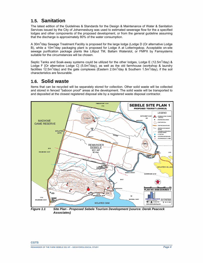
1.6. Solid waste Items that can be recycled will be separately stored for collection. Other solid waste will be collected and stored in fenced “baboon proof” areas at the development. The solid waste will be transported to and deposited at the closest registered disposal site by a registered waste disposal contractor.
Figure 1.1 Site Plan - Proposed Sebele Tourism Development (source: Derek Peacock
Associates)

CGTS
REMAINDER OF THE FARM SEBELE 931 KP – GEOHYDROLOGICAL STUDY Page 5
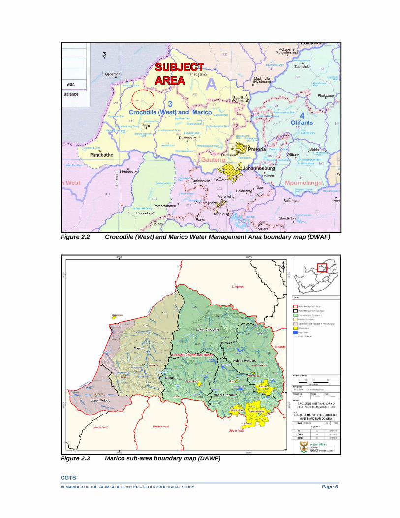
2. REVIEW OF THE PHYSICAL ENVIRONMENT 2.1. Geographical Setting As can be seen in Figure 2.1, the subject area falls within the boundaries of the Ramotshere Moiloa Local Municipality (formerly Zeerust Local Municipality) and the Ngaka Modiri Molema District Municipality (formerly Central District Municipality) and is further situated in the Madikwe magisterial district of the North-West province.
Figure 2.1 Ramotshere Moiloa Local Municipality boundary map (DWAF)
The subject area (Figure 2.2 through to 2.5), falls within both quaternary catchment areas A32C and A32D of the Marico sub-area of the Crocodile (West) and Marico Water Management Area (WMA). The following key groundwater issues pertain to this WMA (DWA Report No. P WMA 03/000/00/0303, February 2004):
Of obvious concern is the likelihood of an interaction between groundwater and surface water. If the interaction is strong then additional use of groundwater may simply be reducing the surface water resource already allocated to someone else. In some instances (such as in the case of dolomitic aquifers) this interaction can indeed be very strong, whilst across many areas of the country it is so weak as to be negligible. In these circumstances groundwater comprises a huge pool of available water which is only of benefit if it is utilised. Care must always be taken with the issuing of licenses to ensure that both the Groundwater Reserve and other downstream users do not end up being the losers.
The realisation in this and other ISPs is that groundwater offers a huge resource of water which can be tapped, and that this can be a very significant supplement to the national water resource.
Preliminary estimates (National Water Resource Strategy, First Edition, September 2004) indicate the natural mean annual runoff (MAR) for the Marico sub-area to be 172Mm3 and the Ecological Reserve to be 29Mm3/annum or 16.86% of MAR.
With reference to “Classification of significant water resources in the Crocodile West and Marico Water Management Area (WMA 3): WP 10506, DWA, March 2012” in terms of the Categorisation of Groundwater Resource Units (2010) in the Crocodile (West) River Catchment. The following:
Both quaternary catchment areas A32C and A32D are afforded an “A” present status category and “Natural” water resource class.
CGTS
REMAINDER OF THE FARM SEBELE 931 KP – GEOHYDROLOGICAL STUDY Page 6
Figure 2.2 Crocodile (West) and Marico Water Management Area boundary map (DWAF)
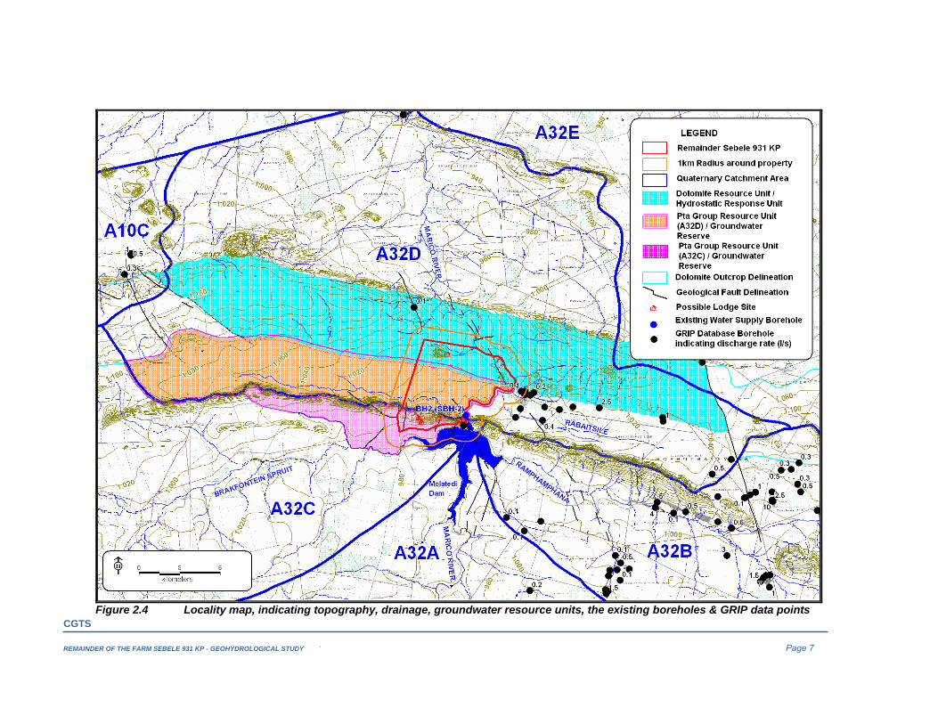
Figure 2.3 Marico sub-area boundary map (DAWF)
CGTS
REMAINDER OF THE FARM SEBELE 931 KP - GEOHYDROLOGICAL STUDY ` Page 7
Figure 2.4 Locality map, indicating topography, drainage, groundwater resource units, the existing boreholes & GRIP data points
CGTS
REMAINDER OF THE FARM SEBELE 931 KP - GEOHYDROLOGICAL STUDY ` Page 8
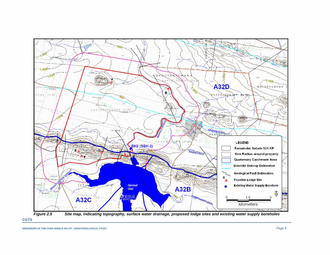
Figure 2.5 Site map, indicating topography, surface water drainage, proposed lodge sites and existing water supply boreholes
CGTS
REMAINDER OF THE FARM SEBELE 391 KP – GEOHYDROLOGICAL STUDY Page 9
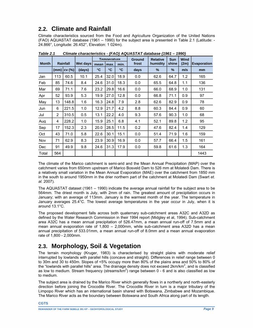
2.2. Climate and Rainfall Climate characteristics sourced from the Food and Agriculture Organization of the United Nations (FAO) AQUASTAT database (1961 – 1990) for the subject area is presented in Table 2.1 (Latitude: -24.866°, Longitude: 26.452°, Elevation: 1 024m). Table 2.1 Climate characteristics - (FAO) AQUASTAT database (1961 – 1990)
Month Rainfall Wet days
Temperature Ground frost
Relativehumidity
Sunshine
Wind (2m) Evaporationmean max. min.
(mm) cv (%) (days) °C °C °C days % % m/s mm
Jan 113 60.5 10.1 25.4 32.0 18.9 0.0 62.6 64.7 1.2 165
Feb 85 74.6 8.4 24.6 31.0 18.3 0.0 65.5 64.8 1.1 136
Mar 69 71.1 7.6 23.2 29.8 16.6 0.0 66.0 68.9 1.0 131
Apr 52 93.9 5.3 19.9 27.0 12.8 0.0 66.8 71.1 0.9 97
May 13 148.8 1.6 16.3 24.8 7.9 2.8 62.6 82.9 0.9 78
Jun 6 221.5 1.0 12.9 21.7 4.2 8.8 60.3 84.4 0.9 60
Jul 2 310.5 0.5 13.1 22.2 4.0 9.3 57.6 90.3 1.0 68
Aug 4 228.2 1.0 15.9 25.1 6.8 4.1 52.1 89.8 1.2 95
Sep 17 152.3 2.3 20.0 28.5 11.5 0.2 47.6 82.4 1.4 129
Oct 43 71.0 5.8 22.6 30.1 15.1 0.0 51.4 71.9 1.6 159
Nov 71 62.9 8.3 23.9 30.9 16.9 0.0 57.7 66.4 1.5 161
Dec 91 49.9 9.8 24.6 31.3 17.9 0.0 59.8 61.6 1.3 164
Total 564 1443
The climate of the Marico catchment is semi-arid and the Mean Annual Precipitation (MAP) over the catchment varies from 650mm upstream of Marico Bosveld Dam to 526 mm at Molatedi Dam. There is a relatively small variation in the Mean Annual Evaporation (MAE) over the catchment from 1850 mm in the south to around 1950mm in the drier northern part of the catchment at Molatedi Dam (Swart et. al. 2007).
The AQUASTAT dataset (1961 – 1990) indicate the average annual rainfall for the subject area to be 564mm. The driest month is July, with 2mm of rain. The greatest amount of precipitation occurs in January; with an average of 113mm. January is the warmest month of the year. The temperature in January averages 25.4°C. The lowest average temperatures in the year occur in July, when it is around 13.1°C.
The proposed development falls across both quaternary sub-catchment areas A32C and A32D as defined by the Water Research Commission in their 1994 report (Midgley et al, 1994). Sub-catchment area A32C has a mean annual precipitation of 526.47mm, a mean annual run-off of 7.5mm and a mean annual evaporation rate of 1,800 – 2,000mm, while sub-catchment area A32D has a mean annual precipitation of 533.01mm, a mean annual run-off of 8.0mm and a mean annual evaporation rate of 1,800 - 2,000mm.
2.3. Morphology, Soil & Vegetation The terrain morphology (Kruger, 1983) is characterised by straight plains with moderate relief interrupted by lowlands with parallel hills (concave and straight). Differences in relief range between 0 to 30m and 30 to 450m. Slopes of <5% occupy more than 80% of the plains area and 50% to 80% of the “lowlands with parallel hills” area. The drainage density does not exceed 2km/km2, and is classified as low to medium. Stream frequency (streams/km2) range between 0 - 6 and is also classified as low to medium.
The subject area is drained by the Marico River which generally flows in a northerly and north-easterly direction before joining the Crocodile River. The Crocodile River in turn is a major tributary of the Limpopo River which has an international basin shared with Botswana, Zimbabwe and Mozambique. The Marico River acts as the boundary between Botswana and South Africa along part of its length.

CGTS
REMAINDER OF THE FARM SEBELE 391 KP – GEOHYDROLOGICAL STUDY Page 10
The study area falls within soil mapping unit 1 of the Institute for Soil, Climate and Water (ISCW) broad natural homogeneous soil zone (BNHSZ) regions (Schulze et. al, 1997). This assigns a soil depth of >900mm to 70% and 450 to 900mm to 30% of unit 4. Unit 4 comprises of 70% SaLm (sandy loam – 10 to 20% clay content), 20% SaCl (sandy clay - more than 35% clay content) and 10% Cl (clay), typically supporting a medium drainage rate.
The major habitats at Madikwe Game Reserve (Trinkel et al., 2009) vary from Mixed Kalahari Thornveld and Shrub Bushveld in the north to Mixed Bushveld in the south (Acocks, 1988). A 30% increase in the bush density was recorded at Madikwe between 1955 and 1998 (Dawid Ward, Observations of Environmental Change in South Africa, 2011)
2.4. Land use Currently the Sebele property is not being used for any purpose. One residence exists on the centre section of the farm. An existing private runway is situated just west of this existing residence (old farmhouse). Old dilapidated buildings that previously functioned as a commercial lodge exist on the eastern foot of Lotteringskop. Molatedi Village is located 1km to the east and adjacent northeast the Madikwe Game Reserve. The Molatedi Dam fronts the southern boundary of the property. The property is surrounded by large farm portions to the west and north within the Madikwe Game Reserve that accommodate tourist lodges. The property is bordered on 3 sides by nature orientated and/or tourism facilities. Thakadu River Camp is the nearest tourist Lodge and is situated approximately 3km north of any of the proposed (possible) development sites on the Sebele property. The other nearest lodge (Jamala Royal Safari Lodge) is situated approximately 4km to the west of the closest site of the proposed development. The property has much greater recreational than agricultural “production” potential and lends itself better towards the use as a game farm/nature area. The total area that will physically be taken up by the proposed tourist accommodation, supporting facilities and infrastructure is estimated to be less than 20ha or less than 0.5% of the total property area.
2.5. Local setting The 4,014ha Sebele property is straddled by the water divide between quaternary catchment areas A32C and A32D with the portion across the latter consisting of two Resource Units (RU) of which one (Northern Dolomite Outcrop) can possible be further divided due to compartmentalization (Figure 2.4).
From a groundwater perspective, it is important to have some knowledge of the locality and extent of surface drainage in close proximity to any development, as they usually represent receptors for the ground water system. Surface infiltration sources usually represent constant head influx boundaries. A locality map indicating the local setting is portrayed in Figure 2.5.
The following comments are relevant: The eastern boundary of the property (12km) is formed by the (perennial) Marico River. The
identified groundwater reserve / flow regime pertaining to the Pretoria Group RU (A32D) to the west of the Marico River, south of the Malmani dolomite contact (Northern Dolomite Outcrop), is drained to the east by a non-perennial tributary (+12.12km total drainage length) of the Marico River. o The topography across this preliminary reserve slope from roughly 1,100mamsl in the west to
<940mamsl along the banks of the Marico River in the east. o The riverbed immediately downstream of Molatedi Dam wall is dry. Water is released further
downstream every 3 to 4 days for irrigation and supply to Botswana. o The only existing borehole on the Sebele property is located in this preliminary reserve.
The identified Malmani dolomite RU is drained to the north by the Marico River. A non-perennial fountain is located at Lotteringskop. o Two intermittent tributaries originate around Lotteringskop. They join each other to the east
before the confluence with the Marico River. Another two minor intermittent tributaries can be seen to join the Marico River between this confluence and Klein-Lotteringskop.
South of the watershed, the identified groundwater reserve / flow regime pertaining to the Pretoria Group RU (A32C) is bounded by the Molatedi Dam, the intermittent Brakfontein Spruit and one of its tributaries. o The topography across this preliminary reserve slope from 1,228mamsl along the water divide
in the northwest down to <960mamsl along the Molatedi Dam’s waterfront.

CGTS
REMAINDER OF THE FARM SEBELE 931 KP - GEOHYDROLOGICAL STUDY ` Page 11
Figure 3.1 Regional Geological Map (1:250 000 geological map 2426 Thabazimbi)
CGTS
REMAINDER OF THE FARM SEBELE 391 KP – GEOHYDROLOGICAL STUDY Page 12
3. GEOLOGY
3.1. Regional Geology A map showing part of the 1:250 000 Thabazimbi Geological Sheet (2426), indicating the subject area is presented in Figure 3.1.
The Transvaal Sequence fills an east-west elongated basin in the south-central part of the Transvaal and includes the corresponding succession in the Potchefstroom Synclinorium (Stratigraphy of South Africa, Handbook 8, Geological Survey, 1980).
The subject area is located along the western part of the northern rim of this basin, some 62km northwest of the Pilanesberg Complex, and features rocks of the Dolomite Series (Malmani Subgroup) followed upon by rocks of the Pretoria Series (Pretoria Group), namely the Timeball Hill, Daspoort and Magaliesberg Stages (Formations).
South of the subject area to the west and north of the Pilanesberg Complex are rocks of the Bushveld Complex, which have intruded the Transvaal Sequence strata concordantly and at a level corresponding to that of the top of the Magaliesberg Quartzite. Exceptions are found in the western part of the map area where the complex is floored by rocks of the Rayton Formation and to the north and south of the Pilanesberg Complex where the basic rocks have intruded somewhat lower down.
To the far southeast, more or less on the contact between the basic and the acid rocks of the Bushveld Complex is the Pilanesberg Complex. The Pilanesberg Complex, which measures some 25km across, is a very large body of intrusive alkaline rocks intruded by dolerite dykes and kimberlite pipes and has associated with it alkaline dykes of extreme length consisting of syenite and lesser diabase. The dykes trend roughly 150 degrees and are recorded from north of the complex southward as far as the Vaal River.
Basic dykes and sills are very prevalent at certain stratigraphic levels below the Bushveld Complex in the Pretoria Group and the majority are found in the Silverton and the Stubenkop Formations.
3.2. Local Geology Dolomite beds are mainly composed of magnesian limestone with some subordinate bands of chert, a compact siliceous rock present in the form of nodules, lenses and layers (Du Toit, 1954; Van der Meulen, 1979). Karst development (Northern Dolomite Outcrop – A32D) is mostly absent or localised (DWA, Guideline for groundwater resources within dolomitic areas in SA, Volume 2, August 2006). The Timeball Hill Stage consists of white and red quartzites parted by shales (Du Toit, 1954; Van der Meulen, 1979). This group is discerned from other stages by the presence of siliceous bands of iron-ore in the quartzites (Du Toit, 1954). Following on the Timeball Hill Stage is the Daspoort Stage which can be identified in the field by thick bodies of concomitant lavas at the base of the shales, the so called ‘Ongeluk Volcanics’ (Du Toit, 1954). Rocks of Magaliesberg Stage encircle the Bushveld Igneous Complex and are thus highly fragmented and metamorphosed. Locally the strata of the Pretoria Group generally dip to the south at angles ranging between 20 to 28 degrees. A diabase sill intruded into the shale south of the “Timeball Hill Series” quartzite sub-outcropping can be seen to transect the central portion of the subject area (Figure 3.1). A number of mostly NNE trending minor faults, involving small outcrop displacements, probably originating during or after emplacement of the Bushveld Igneous Complex are present across the subject area. Two more regional NW trending fault zones can be seen to transect the north-eastern part of the Sebele property to the east and in close proximity to the Marico River as well as the south-eastern part of the property bounded by the Molatedi Dam. A prominent ESE lineament and a lesser NNE trending one transecting it, is evident across the dolomite south of Lotteringskop (Google imagery). Geophysical surveying (Appendix II) across the more prominent one indicates this feature to dip in excess of 200 to the south. Proposed water supply borehole SBH-5 (60m deep - Appendix III, Figure 5.2) was drilled immediately down dip of this feature’s magnetic signal. No intrusive rocks were intersected.

CGTS
REMAINDER OF THE FARM SEBELE 391 KP – GEOHYDROLOGICAL STUDY Page 13
3.3. Geotechnical Investigation With reference to the Geotechnical Desk Study Investigation: Remainder of Sebele 931 KP, Johann van der Merwe (Pty) Ltd. September 2015, as well as the commissioning of the additional water supply boreholes (Section 5.3), the following:
The entire northern portion of the property consist of outcrop and sub-outcrop of hard rock pinnacle dolomite, covered by a thin veneer of dark brown, sandy soil (Soil Zone “D” materials).
The northern portion of the site (Malmani Subgroup dolomite) classifies as a Site Class “P” according to the National Home Builders Registration Council’s (NHBRC) Standards and Guidelines of 1999. The area is underlain by shallow dolomite and based on the investigation carried out by Geotechniques cc the area investigated around the old lodge, classifies as having an Inherent Hazard Class (IHC) of IHC2 which implies that there is a low to moderate potential for small sinkholes to develop in both a non-dewatering and dewatering scenario.
However in terms of the groundwater resources of the northern dolomite outcrop (quaternary catchment areas A32D and A32E), karst development is either absent or localised and borehole yields usually <2l/s (Guideline for groundwater resources within dolomitic areas in SA, Volume 2, DWAF, August 2006).
Newly commissioned borehole SBH-5 (60m deep) intersected a 1m soil profile over weathered, fractured dolomite with chert up to a depth of 18m below surface. The rest of the profile included weathered shale up to a depth of 24mbs, fractured to slightly fractured quartzite up to a depth of 27mbs and fresh dolomite with chert (some hairline fracturing present) up to a depth of 57mbs. The borehole was terminated in fresh, very hard dolomite with chert at a depth of 60mbs.
To the south the soil profile across the broad central valley can be expected to consist of a thin to moderate veneer of sandy and gravelly soils underlain by very soft rock to soft rock shale, dipping towards the south at an average dip of some 20 degrees (Soil Zone “C”). Numerous outcrops of shale were observed in the gravel road that bisects the central portion of the site and contains prominent bedding planes as well as randomly oriented and steeply dipping joint planes.
Borehole SEB-1A drilled south and in close proximity to the contact between the Timeball Hill Formation and the underlying dolomites intersected a 1m soil profile over weathered, fractured shale up to a depth of 40mbs, followed by fresh shale up to a depth of 55mbs. The borehole was terminated in very hard, fresh quartzite at a depth of 60m below surface. The borehole recorded a small water intersection (<0.1l/s) across the transitional zone between fractured and fresh rock. A water level measurement of 24.54mbs was recorded in this borehole before backfilling it 24 hours after completion.
Further down the valley, some 650m up gradient of the intermittent stream draining it, borehole SBH-4 intersected a 1m soil profile over calcrete, calcareous, weathered quartzite up to a depth of 30mbs.
The northern and southern talus slopes along the foot of the prominent mountain range (quartzite ridge) overlooking the Molatedi Dam to the far south consists of abundant coarse, quartzite gravels, cobbles, angular boulders and large slabs of quartzite, clast supported in a sandy matrix (Soil Zone “B”). The horizon probably has a loose to dense consistency and can be expected to be more than 2m thick in places. Towards the south and near the shore of the dam, the material becomes less coarse and probably consists of sand with gravelly lenses.
Some 3.2km east of the western boundary fence, a 10m thick soil profile over highly weathered, weathered shale was observed between the foot of the quartzite ridge and the Molatedi Dam’s high water mark.
Borehole Construction and Geological Log Reports for the newly commissioned water supply boreholes are attached in Appendix III.
CGTS
REMAINDER OF THE FARM SEBELE 931 KP – GEOHYDROLOGICAL STUDY Page 14
4. REGIONAL HYDROGEOLOGY Pertinent hydrogeological information, as gathered from DWAF’s map; Groundwater Resources of the Republic of South Africa, SHEET 1 & 2, 1995 is presented in Table 4.1. . Table 4.1 Groundwater Resources of the Republic of South Africa – Sebele 931 KP Pretoria Group Dolomite SeriesNature of the water-bearing rock / surface/sub-surface lithology
Compact sedimentary strata Dolomite, chert and subordinate limestone.
Saturated interstice (storage medium) / aquifer
Fractures restricted principally to a zone directly below the ground water table. In fresh rock, water bearing fractures are comparatively sparse
Fractures, dissolution features absent or poorly developed
Recommended drilling depth
<20 m below the ground water table 20 – 30 m below the ground water table
Typical storage coefficient <0.001 0.001 Qualitative indication of spatial distribution of storage media based on drilling success rate
<40% <40%
Probability of drilling a successful borehole (Accessibility)
<40%. (A borehole is deemed successful if upon completion it yields more than 0.1L/s.)
<40%. (A borehole is deemed successful if upon completion it yields more than 0.1L/s.)
Probability of drilling a successful borehole, yielding more than 2L/s (Exploitability)
10 - 20% 10 - 20%
Mean depth to water table, according to Vegter (1995) Standard deviation from mean (m)
20 m – 30 m 20 m – 30 m < 15 m 15 - 25 m
Typical mean annual recharge
Ranges between 5mm/a – 10mm/a (0.94 - 0.95% to 1.88 - 1.90% of MAP
Ranges between 5mm/a – 10mm/a (0.94% - 1.88% of MAP 533.01mm/a)
Groundwater component of river baseflow. Mean Annual Flow.
Negligible Negligible
Groundwater quality
TDS < 500mg/l (lower standard deviation) and 1000-1500mg/l (upper standard deviation). Nitrate concentration as N exceeds 10mg/l in more than 20% of the samples analysed
TDS < 300mg/l (lower standard deviation) and 500-1000mg/l (upper standard deviation). Nitrate concentration as N exceeds 10mg/l in more than 20% of the samples analysed
Hydro-chemical type Type B water (represented by > 60% of the samples analysed). With type B, the major cations being Ca and/or Mg and HCO3 the dominant anion
Type B water (represented by > 60% of the samples analysed). With type B, the major cations being Ca and/or Mg and HCO3 the dominant anion
Pertinent hydrogeological information, as gathered from DWAF’s 1: 500 000 Hydrogeological map series of the Republic of South Africa, 2326 Polokwane (2003) is presented in Table 4.2. Table 4.2 1: 500 000 Hydrogeological map series 2326 Polokwane Pretoria Group Dolomite Series Nature of the water-bearing rock / surface/sub-surface lithology
Undifferentiated rocks of mixed lithologies Compact sedimentary strata
Predominately carbonate rocks (dolomite) Dolomite, chert and subordinate limestone.
Saturated interstice (storage medium) / aquifer type
Intergranular and fractured Fractured, (Karst development is either absent or localised
Borehole yield class (median l/s) (excluding dry boreholes)
Ranges between 0.5 L/s to 2.0L/s Ranges between 0.5 L/s to 2.0 L/s
Elevation above sea level 800 -1,200 m 800 -1,200 m Mean annual precipitation 300 – 400 mm 300 – 400 mm Groundwater quality
Electrical conductivity ranges between 70mS/m – 300mS/m
Electrical conductivity ranges between 70mS/m – 300mS/m
CGTS
REMAINDER OF THE FARM SEBELE 931 KP – GEOHYDROLOGICAL STUDY Page 15
Pertinent hydrogeological information, as gathered from DWAF’s map; Groundwater Harvest Potential of the Republic of South Africa, 1996 is presented in Table 4.3. Table 4.3 Groundwater Harvest Potential of the Republic of South Africa
Pretoria Group Dolomite Series Maximum volume of groundwater (m3/km2/annum) that may annually be abstracted per surface area of an aquifer system to preserve a sustained abstraction
4,000 - 6,000 m3/km2/annum 25,000 - 50,000 m3/km2/annum
Factors restricting harvest potential Volume of effective storage Variability of annual recharge Average borehole yield (geometric mean of blow yield l/s)
0.4 - 0.6l/s 0.6 – 0.8l/s
Groundwater quality
The geometric mean concentration of TDS is 500 - 750 mg/l
The geometric mean concentration of TDS is 500 - 750 mg/l
The 1: 500 000 Hydrogeological map series indicate the following typical groundwater occurrences for the Pretoria Group: Basins of weathering; Joints and fractures in competent arenaceous rocks related to tensional or compressional stresses
and off-loading; Joints and fractures occurring in contact zones related to heating and cooling of country rock,
caused by the intrusion of dykes and sills; Contacts between different rock lithologies, and bedding planes within sedimentary rock units. Faults and associated shear zones.
The groundwater resources of the northern dolomite outcrop (quaternary catchment areas A32D and A32E) are mostly limited and underdeveloped and the area could be ecologically sensitive. In the west in particular groundwater quality is pristine and some contribution to base flow can be anticipated. Karst development is either absent or localised and borehole yields usually <2l/s (Guideline for groundwater resources within dolomitic areas in SA, Volume 2, DWAF, August 2006). The 1:6 000 000 Map, Aquifer Classification of South Africa’s Susceptibility Matric [Minor aquifer vs. Least & Most Vulnerability ratings] is indicative of a Low Susceptibility for the Pretoria Group RU’s and a High Susceptibility for the dolomitic RU. Aquifer susceptibility is a qualitative measure of the relative ease with which a groundwater body can be potentially contaminated by anthropogenic activities and which includes both aquifer vulnerability and the relative importance of the aquifer in terms of its classification. Although no data for the larger subject area were found on DWA’s National Groundwater Archive (NGA), the available data points from the GRIP (Groundwater Resource Information Project) database indicating borehole discharge rates are indicated in Figure 2.4. Albeit the paucity of the data, recorded borehole discharge rates to the east of the Remainder of Sebele 931 KP are indicated to range between 0.1L/s and 2.50L/s.
CGTS
REMAINDER OF THE FARM SEBELE 931 KP – GEOHYDROLOGICAL STUDY Page 16
5. LOCAL HYDROGEOLOGY The local hydrogeology will be discussed at the hand of the following:
The recent hydro-census performed in and around the subject area as well as the groundwater samples taken during the survey;
Information sourced the National Groundwater Archive (NGA), as well as from other studies and publications;
The commissioning of additional water supply boreholes;
The pumping test and sampling performed on the existing and newly commissioned water supply boreholes.
A map delineating the Remainder of the farm Sebele 931 KP, with the existing and proposed water supply boreholes as well as the external groundwater users’ boreholes surveyed during the recent hydro-census is presented in Figure 5.1 and Figure 5.2.
5.1. Lateral extent of groundwater zone Two types of aquifer boundaries are anticipated to exist within the zones of influence pertaining to the proposed development on the Remainder of the farm Sebele 931 KP: Physical aquifer boundaries such as impermeable dolerite dykes and sills, or other geological
discontinuities, for example where layers pinch out or outcrop.
Hydraulic aquifer boundaries such as surface infiltration sources, which usually represent constant head influx boundaries, streams that act as groundwater discharge boundaries and groundwater divides which act as no-flow boundaries.
As already stated, the 4,014ha Sebele property is straddled by the water divide between quaternary catchment areas A32C and A32D with the portion across the latter consisting of two Resource Units (RU) of which one (the Northern Dolomite Outcrop) can possible be further divided due to compartmentalization (Figure 2.4 and Figure 5.1): The 105km2 identified groundwater reserve / flow regime pertaining to the Pretoria Group RU
(A32D) to the west of the Marico River, south of the Malmani dolomite contact (Northern Dolomite Outcrop), is drained to the east by a non-perennial tributary of the Marico River; o The western and southern boundary to this domain is constituted by the water divide between
quaternary catchment areas A32C and A32D; o The total drainage length pertaining to the intermittent stream draining this preliminary reserve
is some 12.12km. o The eastern boundary constituted by the Marico River is some 6.4km in length. o Some hydraulic interconnection with the dolomitic RU to the north can be expected.
The 224km2 identified Malmani dolomite RU is drained to the north by the Marico River; o Some groundwater baseflow contribution can be expected along the Marico river (total
drainage length some 11km); o The northern boundary to this flow regime is the contact with the Black Reef and some
hydraulic interconnection between the two RU’s can be expected; o The eastern boundary to this flow regime was selected along a regional fault zone that has
potentially been intruded by diabase; o The western boundary was somewhat arbitrarily selected along a lesser fault zone transecting
the RU; o Apart from the fountain at Lotteringskop, another two fountains are indicated on the geological
sheet for the area to the west of the Marico River on Genadendal 116 and Mooifontein 97. South of the watershed, the 36.5km2 identified groundwater reserve / flow regime pertaining to the
Pretoria Group RU (A32C) is bounded by the Molatedi Dam, the intermittent Brakfontein Spruit and one of its tributaries.
Receptors include the groundwater regime underlying the site, the external groundwater users’ abstracting from the same hydrostatic response units as well as the different flow regimes’ groundwater discharge boundaries represented by the Marico River and its tributaries draining these preliminary reserves.
CGTS
REMAINDER OF THE FARM SEBELE 931 KP - GEOHYDROLOGICAL STUDY ` Page 17
Figure 5.1 Existing and proposed Sebele water supply boreholes as well as the hydro-census points surveyed
CGTS
REMAINDER OF THE FARM SEBELE 931 KP - GEOHYDROLOGICAL STUDY ` Page 18
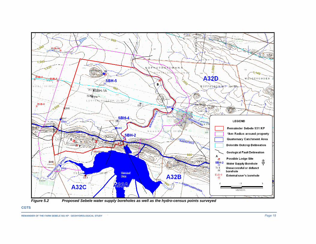
Figure 5.2 Proposed Sebele water supply boreholes as well as the hydro-census points surveyed
CGTS
REMAINDER OF THE FARM SEBELE 931 KP – GEOHYDROLOGICAL STUDY Page 19
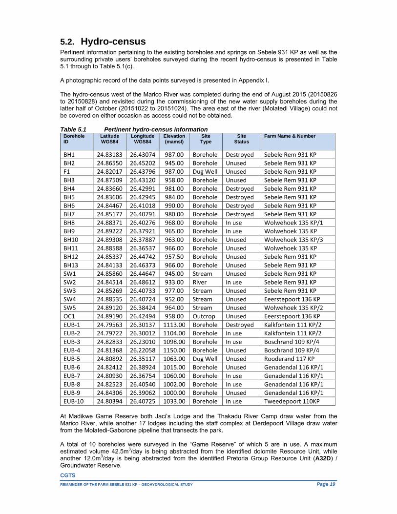
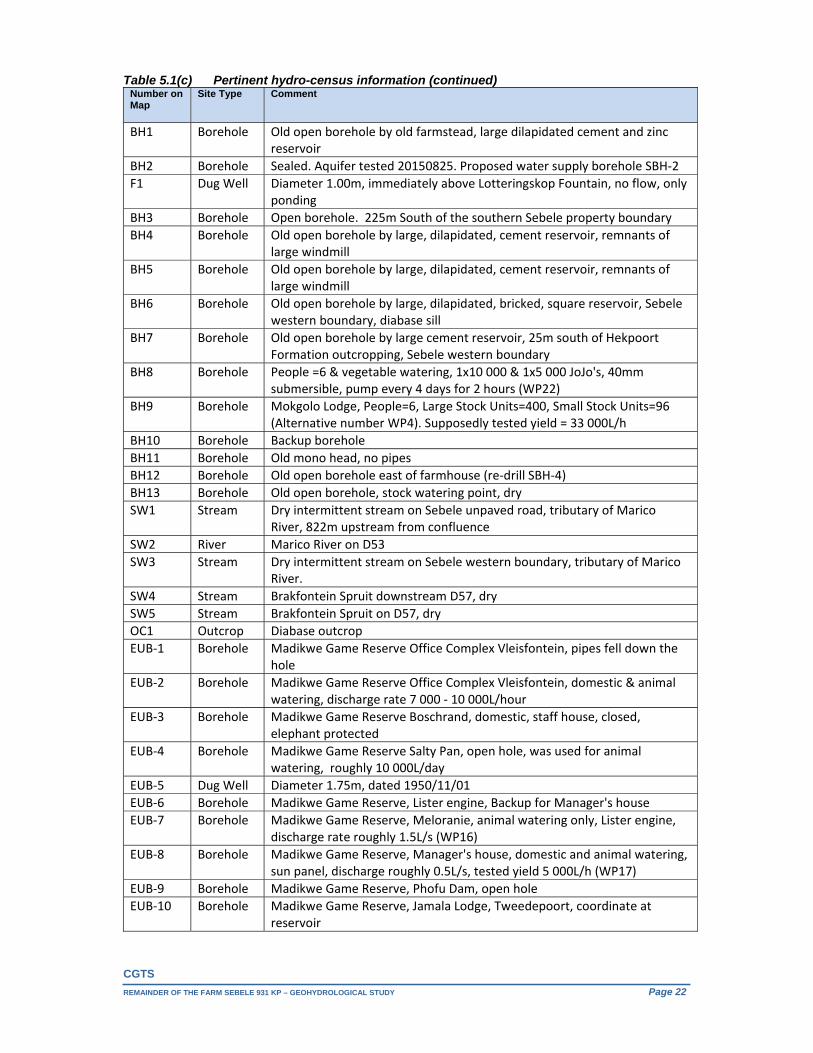
5.2. Hydro-census Pertinent information pertaining to the existing boreholes and springs on Sebele 931 KP as well as the surrounding private users’ boreholes surveyed during the recent hydro-census is presented in Table 5.1 through to Table 5.1(c). A photographic record of the data points surveyed is presented in Appendix I. The hydro-census west of the Marico River was completed during the end of August 2015 (20150826 to 20150828) and revisited during the commissioning of the new water supply boreholes during the latter half of October (20151022 to 20151024). The area east of the river (Molatedi Village) could not be covered on either occasion as access could not be obtained. Table 5.1 Pertinent hydro-census information
Borehole ID
Latitude WGS84
Longitude WGS84
Elevation (mamsl)
SiteType
SiteStatus
Farm Name & Number
BH1 24.83183 26.43074 987.00 Borehole Destroyed Sebele Rem 931 KP
BH2 24.86550 26.45202 945.00 Borehole Unused Sebele Rem 931 KP
F1 24.82017 26.43796 987.00 Dug Well Unused Sebele Rem 931 KP
BH3 24.87509 26.43120 958.00 Borehole Unused Sebele Rem 931 KP
BH4 24.83660 26.42991 981.00 Borehole Destroyed Sebele Rem 931 KP
BH5 24.83606 26.42945 984.00 Borehole Destroyed Sebele Rem 931 KP
BH6 24.84467 26.41018 990.00 Borehole Destroyed Sebele Rem 931 KP
BH7 24.85177 26.40791 980.00 Borehole Destroyed Sebele Rem 931 KP
BH8 24.88371 26.40276 968.00 Borehole In use Wolwehoek 135 KP/1
BH9 24.89222 26.37921 965.00 Borehole In use Wolwehoek 135 KP
BH10 24.89308 26.37887 963.00 Borehole Unused Wolwehoek 135 KP/3
BH11 24.88588 26.36537 966.00 Borehole Unused Wolwehoek 135 KP
BH12 24.85337 26.44742 957.50 Borehole Unused Sebele Rem 931 KP
BH13 24.84133 26.46373 966.00 Borehole Unused Sebele Rem 931 KP
SW1 24.85860 26.44647 945.00 Stream Unused Sebele Rem 931 KP
SW2 24.84514 26.48612 933.00 River In use Sebele Rem 931 KP
SW3 24.85269 26.40733 977.00 Stream Unused Sebele Rem 931 KP
SW4 24.88535 26.40724 952.00 Stream Unused Eeerstepoort 136 KP
SW5 24.89120 26.38424 964.00 Stream Unused Wolwehoek 135 KP/2
OC1 24.89190 26.42494 958.00 Outcrop Unused Eeerstepoort 136 KP
EUB‐1 24.79563 26.30137 1113.00 Borehole Destroyed Kalkfontein 111 KP/2
EUB‐2 24.79722 26.30012 1104.00 Borehole In use Kalkfontein 111 KP/2
EUB‐3 24.82833 26.23010 1098.00 Borehole In use Boschrand 109 KP/4
EUB‐4 24.81368 26.22058 1150.00 Borehole Unused Boschrand 109 KP/4
EUB‐5 24.80892 26.35117 1063.00 Dug Well Unused Rooderand 117 KP
EUB‐6 24.82412 26.38924 1015.00 Borehole Unused Genadendal 116 KP/1
EUB‐7 24.80930 26.36754 1060.00 Borehole In use Genadendal 116 KP/1
EUB‐8 24.82523 26.40540 1002.00 Borehole In use Genadendal 116 KP/1
EUB‐9 24.84306 26.39062 1000.00 Borehole Unused Genadendal 116 KP/1
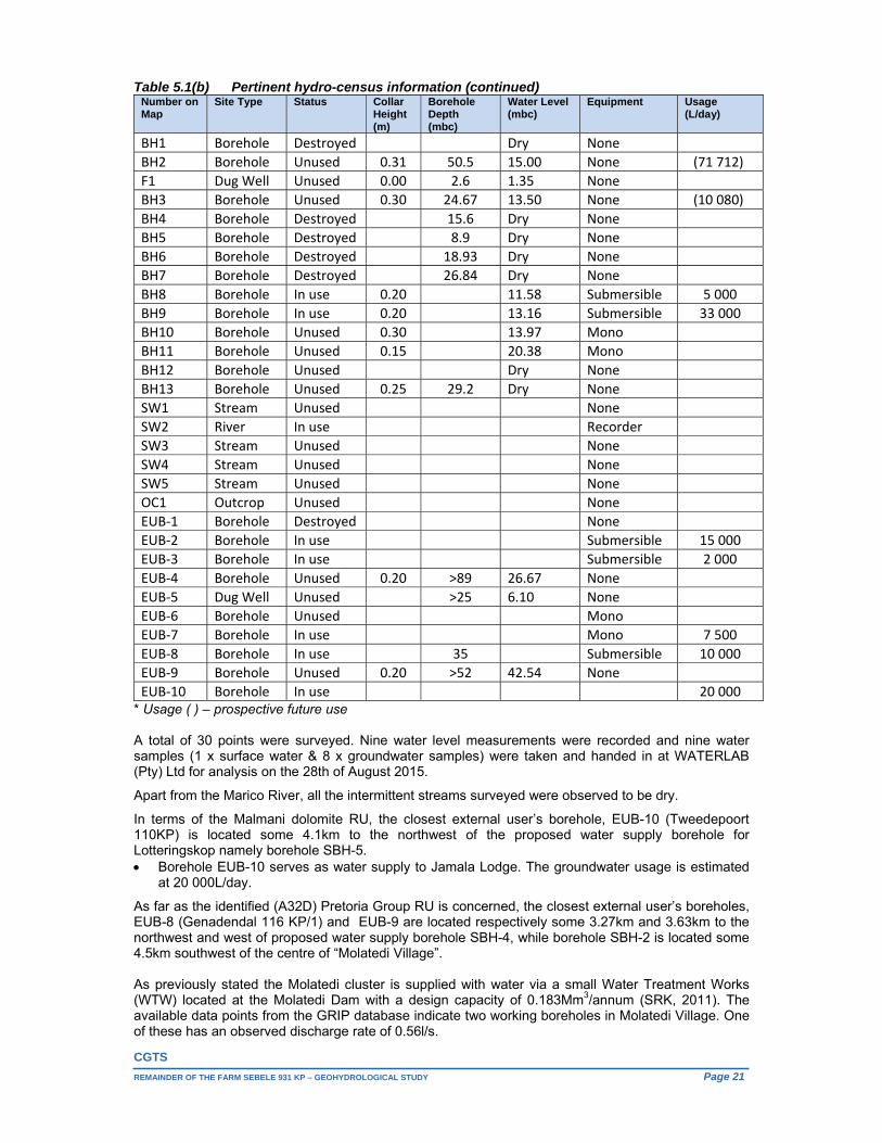
EUB‐10 24.80394 26.40725 1033.00 Borehole In use Tweedepoort 110KP At Madikwe Game Reserve both Jaci’s Lodge and the Thakadu River Camp draw water from the Marico River, while another 17 lodges including the staff complex at Derdepoort Village draw water from the Molatedi-Gaborone pipeline that transects the park. A total of 10 boreholes were surveyed in the “Game Reserve” of which 5 are in use. A maximum estimated volume 42.5m3/day is being abstracted from the identified dolomite Resource Unit, while another 12.0m3/day is being abstracted from the identified Pretoria Group Resource Unit (A32D) / Groundwater Reserve.

CGTS
REMAINDER OF THE FARM SEBELE 931 KP – GEOHYDROLOGICAL STUDY Page 20
Table 5.1(a) Pertinent hydro-census information (continued) Borehole ID
Owner Contact Person Cell Number Sample Date
Sample Time
DrainageRegion
BH1 BCPA Amos Setou 082 801 7829 A32D
BH2 BCPA Amos Setou 082 801 7829 20150827 07h00 A32D
F1 BCPA Amos Setou 082 801 7829 20150826 15h50 A32D
BH3 DWAF 20150828 08h20 A32C
BH4 BCPA Amos Setou 082 801 7829 A32D
BH5 BCPA Amos Setou 082 801 7829 A32D
BH6 BCPA Amos Setou 082 801 7829 A32D
BH7 BCPA Amos Setou 082 801 7829 A32D
BH8 BCPA Amos Setou 082 801 7829 20150827 13h01 A32C
BH9 BCPA Amos Setou 082 801 7829 20150826 12h50 A32C
BH10 BCPA Amos Setou 082 801 7829 A32C
BH11 BCPA Amos Setou 082 801 7829 A32C
BH12 BCPA Amos Setou 082 801 7829 A32D
BH13 BCPA Amos Setou 082 801 7829 A32D
SW1 BCPA Amos Setou 082 801 7829 A32D
SW2 BCPA Amos Setou 082 801 7829 20150826 12h00 A32D
SW3 BCPA Amos Setou 082 801 7829 A32D
SW4 BCPA Amos Setou 082 801 7829 A32C
SW5 BCPA Amos Setou 082 801 7829 A32C
OC1 BCPA Amos Setou 082 801 7829 A32D
EUB‐1 Madikwe Game Reserve Peter Leitner 082 781 5708 A32D
EUB‐2 Madikwe Game Reserve Peter Leitner 082 781 5708 20150827 07h00 A32D
EUB‐3 Madikwe Game Reserve Peter Leitner 082 781 5708 A32D
EUB‐4 Madikwe Game Reserve Peter Leitner 082 781 5708 A32D
EUB‐5 Madikwe Game Reserve Peter Leitner 082 781 5708 A32D
EUB‐6 Madikwe Game Reserve Peter Leitner 082 781 5708 A32D
EUB‐7 Madikwe Game Reserve Peter Leitner 082 781 5708 20150827 10h55 A32D
EUB‐8 Madikwe Game Reserve Peter Leitner 082 781 5708 20150827 11h30 A32D
EUB‐9 Madikwe Game Reserve Peter Leitner 082 781 5708 A32D
EUB‐10 Madikwe Game Reserve Peter Leitner 082 781 5708 A32D Four boreholes belonging to the BCPA were surveyed on Wolwehoek 135 KP of which 2 are in use. One of these (BH8) falls within the identified Pretoria Group Resource Unit (A32C) / Groundwater Reserve. Maximum use from borehole BH8 is estimated at approximately 5.0m3/day. Outside and along the southern boundary of this reserve, immediate south of the Brakfontein Spruit, some 33m3/day is being abstracted from borehole BH9 for cattle watering. This borehole also supplies the Mokgolo Lodge with water. On Sebele 931 KP apart from borehole BH1, another 7 dysfunctional boreholes (BH4 to BH7 as well as BH12 & BH13) were surveyed. No flow was observed at the fountain at Lotteringskop, only ponding. A dug well is present immediately up gradient from the fountain and it would seem that it has been used for water supply in the past. Borehole BH12, located east of the Sebele farmhouse, was re-drilled during the commissioning of the additional water supply boreholes. The hydro-census (west of the Marico River) also coincided with the testing of existing borehole BH2 (SBH-2 - Pretoria Group RU (A32D)).
CGTS
REMAINDER OF THE FARM SEBELE 931 KP – GEOHYDROLOGICAL STUDY Page 21
Table 5.1(b) Pertinent hydro-census information (continued) Number on Map
Site Type Status Collar Height (m)
Borehole Depth (mbc)
Water Level(mbc)
Equipment Usage(L/day)
BH1 Borehole Destroyed Dry None
BH2 Borehole Unused 0.31 50.5 15.00 None (71 712)
F1 Dug Well Unused 0.00 2.6 1.35 None
BH3 Borehole Unused 0.30 24.67 13.50 None (10 080)
BH4 Borehole Destroyed 15.6 Dry None
BH5 Borehole Destroyed 8.9 Dry None
BH6 Borehole Destroyed 18.93 Dry None
BH7 Borehole Destroyed 26.84 Dry None
BH8 Borehole In use 0.20 11.58 Submersible 5 000
BH9 Borehole In use 0.20 13.16 Submersible 33 000
BH10 Borehole Unused 0.30 13.97 Mono
BH11 Borehole Unused 0.15 20.38 Mono
BH12 Borehole Unused Dry None
BH13 Borehole Unused 0.25 29.2 Dry None
SW1 Stream Unused None
SW2 River In use Recorder
SW3 Stream Unused None
SW4 Stream Unused None
SW5 Stream Unused None
OC1 Outcrop Unused None
EUB‐1 Borehole Destroyed None
EUB‐2 Borehole In use Submersible 15 000
EUB‐3 Borehole In use Submersible 2 000
EUB‐4 Borehole Unused 0.20 >89 26.67 None
EUB‐5 Dug Well Unused >25 6.10 None
EUB‐6 Borehole Unused Mono
EUB‐7 Borehole In use Mono 7 500
EUB‐8 Borehole In use 35 Submersible 10 000
EUB‐9 Borehole Unused 0.20 >52 42.54 None
EUB‐10 Borehole In use 20 000* Usage ( ) – prospective future use A total of 30 points were surveyed. Nine water level measurements were recorded and nine water samples (1 x surface water & 8 x groundwater samples) were taken and handed in at WATERLAB (Pty) Ltd for analysis on the 28th of August 2015.
Apart from the Marico River, all the intermittent streams surveyed were observed to be dry.
In terms of the Malmani dolomite RU, the closest external user’s borehole, EUB-10 (Tweedepoort 110KP) is located some 4.1km to the northwest of the proposed water supply borehole for Lotteringskop namely borehole SBH-5. Borehole EUB-10 serves as water supply to Jamala Lodge. The groundwater usage is estimated
at 20 000L/day.
As far as the identified (A32D) Pretoria Group RU is concerned, the closest external user’s boreholes, EUB-8 (Genadendal 116 KP/1) and EUB-9 are located respectively some 3.27km and 3.63km to the northwest and west of proposed water supply borehole SBH-4, while borehole SBH-2 is located some 4.5km southwest of the centre of “Molatedi Village”. As previously stated the Molatedi cluster is supplied with water via a small Water Treatment Works (WTW) located at the Molatedi Dam with a design capacity of 0.183Mm3/annum (SRK, 2011). The available data points from the GRIP database indicate two working boreholes in Molatedi Village. One of these has an observed discharge rate of 0.56l/s.
CGTS
REMAINDER OF THE FARM SEBELE 931 KP – GEOHYDROLOGICAL STUDY Page 22
Table 5.1(c) Pertinent hydro-census information (continued) Number on Map
Site Type Comment
BH1 Borehole Old open borehole by old farmstead, large dilapidated cement and zinc reservoir
BH2 Borehole Sealed. Aquifer tested 20150825. Proposed water supply borehole SBH‐2
F1 Dug Well Diameter 1.00m, immediately above Lotteringskop Fountain, no flow, only ponding
BH3 Borehole Open borehole. 225m South of the southern Sebele property boundary
BH4 Borehole Old open borehole by large, dilapidated, cement reservoir, remnants of large windmill
BH5 Borehole Old open borehole by large, dilapidated, cement reservoir, remnants of large windmill
BH6 Borehole Old open borehole by large, dilapidated, bricked, square reservoir, Sebele western boundary, diabase sill
BH7 Borehole Old open borehole by large cement reservoir, 25m south of Hekpoort Formation outcropping, Sebele western boundary
BH8 Borehole People =6 & vegetable watering, 1x10 000 & 1x5 000 JoJo's, 40mm submersible, pump every 4 days for 2 hours (WP22)
BH9 Borehole Mokgolo Lodge, People=6, Large Stock Units=400, Small Stock Units=96 (Alternative number WP4). Supposedly tested yield = 33 000L/h
BH10 Borehole Backup borehole
BH11 Borehole Old mono head, no pipes
BH12 Borehole Old open borehole east of farmhouse (re‐drill SBH‐4)
BH13 Borehole Old open borehole, stock watering point, dry
SW1 Stream Dry intermittent stream on Sebele unpaved road, tributary of Marico River, 822m upstream from confluence
SW2 River Marico River on D53
SW3 Stream Dry intermittent stream on Sebele western boundary, tributary of Marico River.
SW4 Stream Brakfontein Spruit downstream D57, dry
SW5 Stream Brakfontein Spruit on D57, dry
OC1 Outcrop Diabase outcrop
EUB‐1 Borehole Madikwe Game Reserve Office Complex Vleisfontein, pipes fell down the hole
EUB‐2 Borehole Madikwe Game Reserve Office Complex Vleisfontein, domestic & animal watering, discharge rate 7 000 ‐ 10 000L/hour
EUB‐3 Borehole Madikwe Game Reserve Boschrand, domestic, staff house, closed, elephant protected
EUB‐4 Borehole Madikwe Game Reserve Salty Pan, open hole, was used for animal watering, roughly 10 000L/day
EUB‐5 Dug Well Diameter 1.75m, dated 1950/11/01
EUB‐6 Borehole Madikwe Game Reserve, Lister engine, Backup for Manager's house
EUB‐7 Borehole Madikwe Game Reserve, Meloranie, animal watering only, Lister engine, discharge rate roughly 1.5L/s (WP16)
EUB‐8 Borehole Madikwe Game Reserve, Manager's house, domestic and animal watering, sun panel, discharge roughly 0.5L/s, tested yield 5 000L/h (WP17)
EUB‐9 Borehole Madikwe Game Reserve, Phofu Dam, open hole
EUB‐10 Borehole Madikwe Game Reserve, Jamala Lodge, Tweedepoort, coordinate at reservoir
CGTS
REMAINDER OF THE FARM SEBELE 931 KP – GEOHYDROLOGICAL STUDY Page 23
In terms of the (A32C) Pretoria Group RU, the closest external user’s borehole to the proposed large lodge development is BH-3, located some 225m south of the southern Sebele property boundary.
5.3. Commissioning of additional water supply boreholes
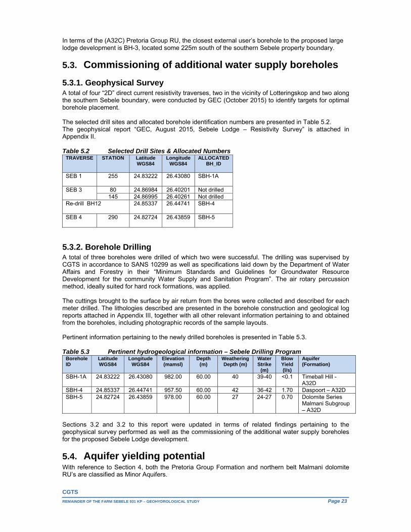
5.3.1. Geophysical Survey A total of four “2D” direct current resistivity traverses, two in the vicinity of Lotteringskop and two along the southern Sebele boundary, were conducted by GEC (October 2015) to identify targets for optimal borehole placement. The selected drill sites and allocated borehole identification numbers are presented in Table 5.2. The geophysical report “GEC, August 2015, Sebele Lodge – Resistivity Survey” is attached in Appendix II. Table 5.2 Selected Drill Sites & Allocated Numbers
5.3.2. Borehole Drilling A total of three boreholes were drilled of which two were successful. The drilling was supervised by CGTS in accordance to SANS 10299 as well as specifications laid down by the Department of Water Affairs and Forestry in their “Minimum Standards and Guidelines for Groundwater Resource Development for the community Water Supply and Sanitation Program”. The air rotary percussion method, ideally suited for hard rock formations, was applied. The cuttings brought to the surface by air return from the bores were collected and described for each meter drilled. The lithologies described are presented in the borehole construction and geological log reports attached in Appendix III, together with all other relevant information pertaining to and obtained from the boreholes, including photographic records of the sample layouts. Pertinent information pertaining to the newly drilled boreholes is presented in Table 5.3. Table 5.3 Pertinent hydrogeological information – Sebele Drilling Program
Borehole ID
Latitude WGS84
Longitude WGS84
Elevation (mamsl)
Depth (m)
Weathering Depth (m)
Water Strike
(m)
Blow Yield (l/s)
Aquifer (Formation)
SBH-1A 24.83222 26.43080 982.00 60.00 40 39-40 <0.1 Timeball Hill -
A32D SBH-4 24.85337 26.44741 957.50 60.00 42 36-42 1.70 Daspoort – A32D SBH-5 24.82724 26.43859 978.00 60.00 27 24-27 0.70 Dolomite Series
Malmani Subgroup – A32D
Sections 3.2 and 3.2 to this report were updated in terms of related findings pertaining to the geophysical survey performed as well as the commissioning of the additional water supply boreholes for the proposed Sebele Lodge development.
5.4. Aquifer yielding potential With reference to Section 4, both the Pretoria Group Formation and northern belt Malmani dolomite RU’s are classified as Minor Aquifers.
TRAVERSE
STATION Latitude WGS84
Longitude WGS84
ALLOCATED BH_ID
SEB 1 255 24.83222 26.43080 SBH-1A
SEB 3 80 24.86984 26.40201 Not drilled 145 24.86995 26.40261 Not drilled
Re-drill BH12 24.85337 26.44741 SBH-4
SEB 4 290 24.82724 26.43859 SBH-5

CGTS
REMAINDER OF THE FARM SEBELE 931 KP – GEOHYDROLOGICAL STUDY Page 24
The available data points from the GRIP database (Figure 2.4) indicate borehole discharge rates to the east of the Remainder of Sebele 931 KP ranging between 0.1L/s and 2.50L/s. The available data points from this database indicate two working boreholes in Molatedi Village. One of these has an observed discharge rate of 0.56l/s.
The reported borehole yields recorded during the recent hydro-census for the Malmani dolomite RU and contact zone with the overlying Timeball Hill Formation ranged from 1.39L/s to 2.08Ll/s and fall within the 1: 500 000 Hydrogeological map series’ indicated yield class for this RU.
Borehole BH-9’s supposedly tested yielding capacity is said to be 33 000L/h or 9.17l/s and represents an outlier in terms of the regionally indicated yielding capacity. The local geology here is fairly complex and apart from the close proximity of a NNE trending minor fault zone, features Magaliesberg shale surrounded by Bushveld norite (locally anorthositic).
The recommended sustainable long-term combined abstraction rate for the two proposed water supply boreholes located within the Pretoria Group RU (A32D) west of the Marico River is some 2.70L/sec (9.712375m3/hr) for a maximum of 8 hours/day (77.699m3/day), see Section 5.4.1.
The recommended sustainable long-term abstraction rate for the proposed water supply borehole located within the Malmani dolomite RU is some 0.09L/sec (0.3118753/hr) for a maximum of 8 hours/day (2.495m3/day), see Section 5.4.1.
The Remainder of the farm Sebele 931 KP measures some 4014ha, which apart from a number of favourable and still unexplored geological structures, also allows for the suitably spacing of both existing and potential future production boreholes.
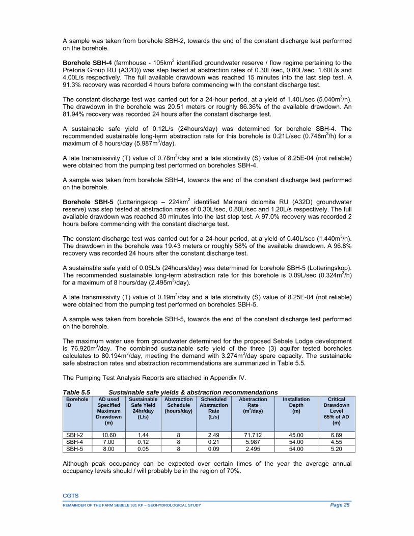
5.4.1. Aquifer testing One existing borehole identified during the recent hydro-census as well as the two successful, newly commissioned boreholes, were aquifer tested by Aquawise Borehole Specialists during September and October 2015. The data obtained from the pumping tests was analysed using the Flow Characteristic Method (FC Method). This program was developed by the Institute for Groundwater Studies at the University of the Free State, Bloemfontein, South Africa. The program evaluates the sustainable yield of a borehole using derivatives, boundary information, error propagation and influence of other boreholes. It is important to keep in mind that the program simulates a 2-year abstraction scenario, using a zero recharge rate. In other words, abstraction is calculated but no groundwater recharge from rainfall is factored in. The program is therefore conservative in its recommended abstraction rates. Table 5.4 Borehole Testing Details
Borehole ID
Latitude WGS84
Longitude WGS84
Elevation (mamsl)
Depth (mbs)
TestDatum Height
(m)
StaticWater Level
(mbd)
Pump Depth (mbc)
AvailableTest
Drawdown (m)
SBH-2 24.86550 26.45202 945.0 50.50 0.75 15.00 45.00 30.00 SBH-4 24.85337 26.44741 957.5 60.00 0.36 30.25 54.00 23.75 SBH-5 24.82724 26.43859 978.0 60.00 0.72 20.47 54.00 33.53
*(mbc) – meters below surface, *(mbc) – meters below casing, *(mbd) – meters below datum Borehole SBH-2 (105km2 identified groundwater reserve / flow regime pertaining to the Pretoria Group RU (A32D)) was step tested at abstraction rates of 0.50L/sec, 1.50L/sec, 3.50L/s, 6.50L/s and 9.40L/s respectively. The full available drawdown was reached 15 minutes into the last step test. A 99.3% recovery was recorded 3.5 hours before commencing with the constant discharge test. The constant discharge test was carried out for a 24-hour period, at a yield of 4.80L/sec (17.280m3/h). The drawdown in the borehole was 7.49 meters or roughly 25% of the available drawdown. A 97.5% recovery was recorded 10 hours after the constant discharge test. A sustainable safe yield of 1.44L/s (24hours/day) was determined for this borehole. The recommended sustainable long-term abstraction rate for this borehole is 2.49L/sec (8.964m3/h) for a maximum of 8 hours/day (71.712m3/day). A late transmissivity (T) value of 12.9m2/day and a late storativity (S) value of 8.25E-04 (not reliable) were obtained from the pumping test performed on boreholes SBH-2.
CGTS
REMAINDER OF THE FARM SEBELE 931 KP – GEOHYDROLOGICAL STUDY Page 25
A sample was taken from borehole SBH-2, towards the end of the constant discharge test performed on the borehole. Borehole SBH-4 (farmhouse - 105km2 identified groundwater reserve / flow regime pertaining to the Pretoria Group RU (A32D)) was step tested at abstraction rates of 0.30L/sec, 0.80L/sec, 1.60L/s and 4.00L/s respectively. The full available drawdown was reached 15 minutes into the last step test. A 91.3% recovery was recorded 4 hours before commencing with the constant discharge test. The constant discharge test was carried out for a 24-hour period, at a yield of 1.40L/sec (5.040m3/h). The drawdown in the borehole was 20.51 meters or roughly 86.36% of the available drawdown. An 81.94% recovery was recorded 24 hours after the constant discharge test. A sustainable safe yield of 0.12L/s (24hours/day) was determined for borehole SBH-4. The recommended sustainable long-term abstraction rate for this borehole is 0.21L/sec (0.748m3/h) for a maximum of 8 hours/day (5.987m3/day). A late transmissivity (T) value of 0.78m2/day and a late storativity (S) value of 8.25E-04 (not reliable) were obtained from the pumping test performed on boreholes SBH-4. A sample was taken from borehole SBH-4, towards the end of the constant discharge test performed on the borehole. Borehole SBH-5 (Lotteringskop – 224km2 identified Malmani dolomite RU (A32D) groundwater reserve) was step tested at abstraction rates of 0.30L/sec, 0.80L/sec and 1.20L/s respectively. The full available drawdown was reached 30 minutes into the last step test. A 97.0% recovery was recorded 2 hours before commencing with the constant discharge test. The constant discharge test was carried out for a 24-hour period, at a yield of 0.40L/sec (1.440m3/h). The drawdown in the borehole was 19.43 meters or roughly 58% of the available drawdown. A 96.8% recovery was recorded 24 hours after the constant discharge test. A sustainable safe yield of 0.05L/s (24hours/day) was determined for borehole SBH-5 (Lotteringskop). The recommended sustainable long-term abstraction rate for this borehole is 0.09L/sec (0.324m3/h) for a maximum of 8 hours/day (2.495m3/day). A late transmissivity (T) value of 0.19m2/day and a late storativity (S) value of 8.25E-04 (not reliable) were obtained from the pumping test performed on boreholes SBH-5. A sample was taken from borehole SBH-5, towards the end of the constant discharge test performed on the borehole. The maximum water use from groundwater determined for the proposed Sebele Lodge development is 76.920m3/day. The combined sustainable safe yield of the three (3) aquifer tested boreholes calculates to 80.194m3/day, meeting the demand with 3.274m3/day spare capacity. The sustainable safe abstraction rates and abstraction recommendations are summarized in Table 5.5. The Pumping Test Analysis Reports are attached in Appendix IV. Table 5.5 Sustainable safe yields & abstraction recommendations
Borehole ID
AD used Specified Maximum Drawdown
(m)
Sustainable Safe Yield 24hr/day
(L/s)
Abstraction Schedule
(hours/day)
Scheduled Abstraction
Rate (L/s)
Abstraction Rate
(m3/day)
Installation Depth
(m)
Critical Drawdown
Level 65% of AD
(m)
SBH-2 10.60 1.44 8 2.49 71.712 45.00 6.89 SBH-4 7.00 0.12 8 0.21 5.987 54.00 4.55 SBH-5 8.00 0.05 8 0.09 2.495 54.00 5.20
Although peak occupancy can be expected over certain times of the year the average annual occupancy levels should / will probably be in the region of 70%.
CGTS
REMAINDER OF THE FARM SEBELE 931 KP - GEOHYDROLOGICAL STUDY ` Page 26
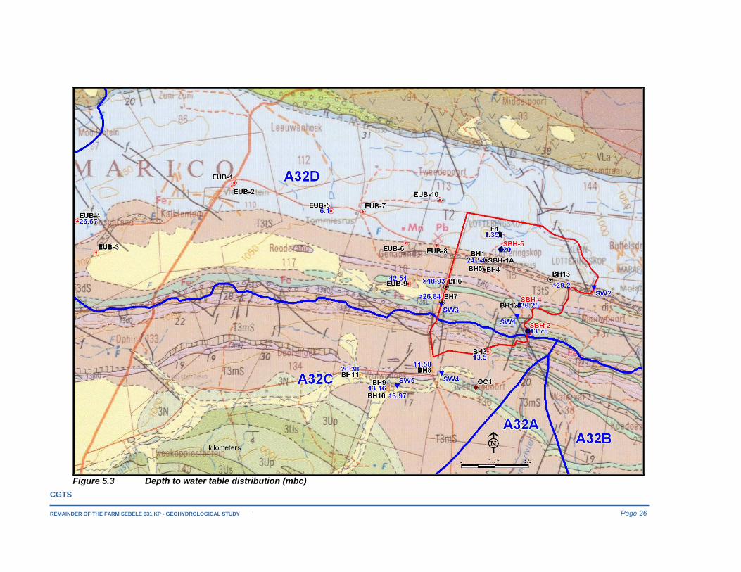
Figure 5.3 Depth to water table distribution (mbc)

CGTS
REMAINDER OF THE FARM SEBELE 931 KP – GEOHYDROLOGICAL STUDY Page 27
5.5. Depth to water table and hydrostatic fluctuations
5.5.1. Depth to water table distribution The depth to the water table observed across the Northern Belt dolomites (2 boreholes), excluding the 2 dug wells, ranged between 20.47mbc and 26.67, averaging at 23.57mbc. The observed water level elevation for borehole SBH-5 is some 27.65m lower than that of the dug well next to the Lotteringskop fountain (F1), suggesting that the intermittent fountain discharge here can probably be associated with the kopje’s regolith itself. The depth to water table (4 boreholes) observed across the Pretoria Group RU (A32D) ranged between 13.75mbc and 42.54mbc, averaging at 27.77mbc. Apart from the insufficient data, the average observed water level elevation pertaining to the dolomite lithological unit across quaternary catchment area A32D is higher than that observed for the overlying Pretoria Group sediments to the south (same quaternary catchment area – identified Pretoria Group RU (A32D)). It is also noteworthy that the borehole depths observed during the recent hydro-census, for a number of the now dysfunctional (historically existing) boreholes (Pretoria Group RU (A32D)) were above the recently observed depth to water level measurements recorded and the inferred water level depths at these localities. The depth to water table (6 boreholes) observed across the Pretoria Group sediments in quaternary catchment A32C ranged between 11.58mbc and 20.38mbc, averaging at 14.60mbc. In all three cases the correlation between the observed water levels and surface topography elevation is poor. The same observation was made in terms of rest water levels for strata representing both the dolomites and the Pretoria Group sediments in quaternary catchment areas A21A and A21B (Hobbs, 2004). The water level elevations observed (October 2015) for both boreholes SBH-2 (931.25mamsl) and SBH-4 (927.25mamsl) are lower than the Marico River’s elevation (935mamsl - 934mamsl) scaled from the 5m flow contour data, indicating the river to be influent (also see Section 5.7.1) across the Pretoria Group RU (A32D). Contrastingly, the October 2015 groundwater elevation observed for borehole SBH-5 (Lotteringskop) is 953mamsl or some 18m - 23m above the Marico River’s terrain elevation across the dolomite RU at distance 2.4km to 4.8km east of this borehole. The observed depth to water table distribution is presented in Figure 5.3.
5.5.2. Hydrostatic fluctuations Time-series groundwater level data, originally captured in the Nation Groundwater Archive (NGA) has been transferred to the Hydstra platform. No information could be obtained from both the NGA and the Hydstra platform for the larger study area. In light of the foregoing, mention is made here of the August 2010 doctoral dissertation “ESTIMATION OF EPISODIC GROUNDWATER RECHARGE IN SEMI-ARID FRACTURED HARD ROCK AQUIFERS”, by E. van Wyk, in which he states that given the highly differential hydro-climatic conditions and hydrogeological environment in semi-arid regions, effective groundwater recharge events are episodic in nature and largely occur once in every five years.
5.5.3. Groundwater flow directions The water level measurements across the larger area are insufficient to draw concrete conclusions on the directions of groundwater flow. None the less, as previously stated, some groundwater baseflow contribution can be expected along the Marico River’s intersection (total drainage length some 11km) of the Malmani dolomite resource unit, as it represents the lowest terrain (<930mamsl to 935mamsl) across this lithological unit’s distribution within quaternary catchment area A32D. The regional groundwater flow vectors across the identified Malmani dolomite RU groundwater reserve is thus expected to be towards the Marico River.
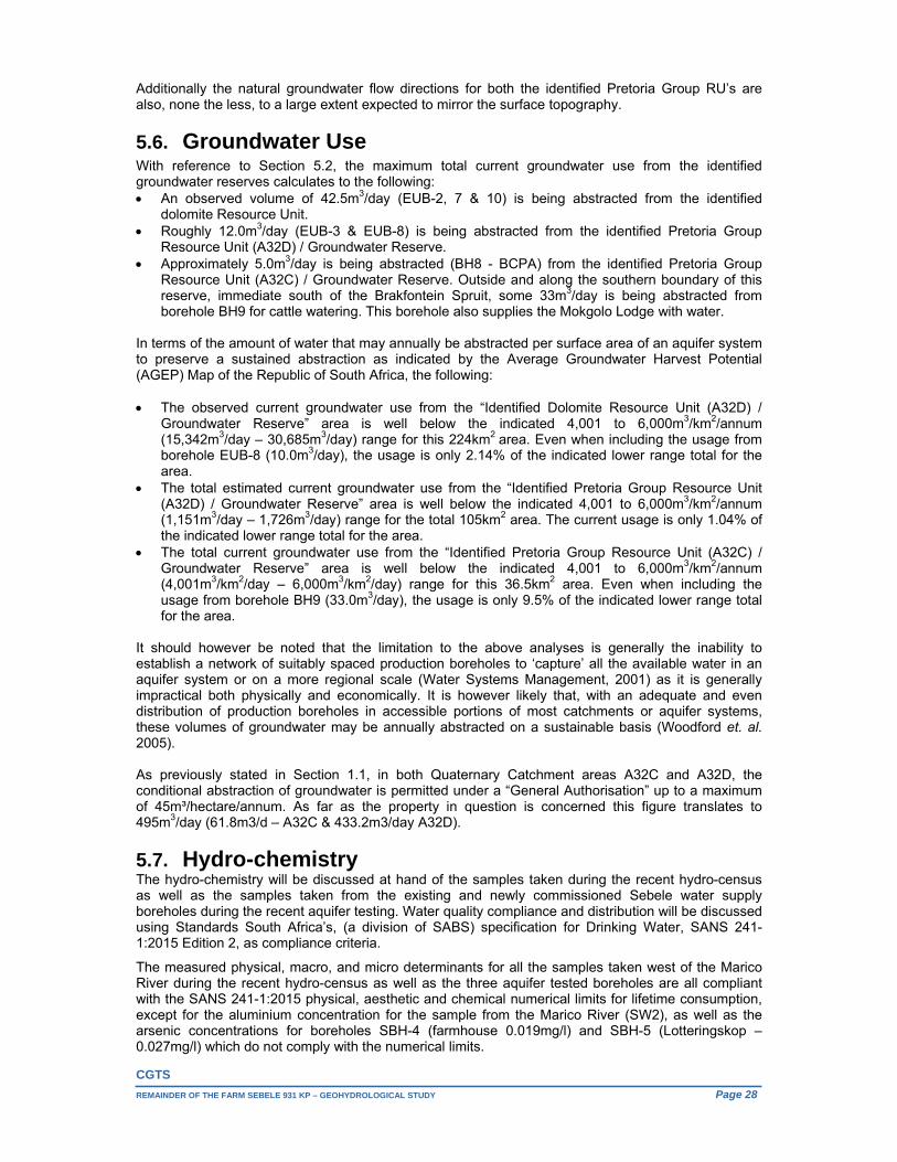
CGTS
REMAINDER OF THE FARM SEBELE 931 KP – GEOHYDROLOGICAL STUDY Page 28
Additionally the natural groundwater flow directions for both the identified Pretoria Group RU’s are also, none the less, to a large extent expected to mirror the surface topography.
5.6. Groundwater Use With reference to Section 5.2, the maximum total current groundwater use from the identified groundwater reserves calculates to the following: An observed volume of 42.5m3/day (EUB-2, 7 & 10) is being abstracted from the identified
dolomite Resource Unit. Roughly 12.0m3/day (EUB-3 & EUB-8) is being abstracted from the identified Pretoria Group
Resource Unit (A32D) / Groundwater Reserve. Approximately 5.0m3/day is being abstracted (BH8 - BCPA) from the identified Pretoria Group
Resource Unit (A32C) / Groundwater Reserve. Outside and along the southern boundary of this reserve, immediate south of the Brakfontein Spruit, some 33m3/day is being abstracted from borehole BH9 for cattle watering. This borehole also supplies the Mokgolo Lodge with water.
In terms of the amount of water that may annually be abstracted per surface area of an aquifer system to preserve a sustained abstraction as indicated by the Average Groundwater Harvest Potential (AGEP) Map of the Republic of South Africa, the following: The observed current groundwater use from the “Identified Dolomite Resource Unit (A32D) /
Groundwater Reserve” area is well below the indicated 4,001 to 6,000m3/km2/annum (15,342m3/day – 30,685m3/day) range for this 224km2 area. Even when including the usage from borehole EUB-8 (10.0m3/day), the usage is only 2.14% of the indicated lower range total for the area.
The total estimated current groundwater use from the “Identified Pretoria Group Resource Unit (A32D) / Groundwater Reserve” area is well below the indicated 4,001 to 6,000m3/km2/annum (1,151m3/day – 1,726m3/day) range for the total 105km2 area. The current usage is only 1.04% of the indicated lower range total for the area.
The total current groundwater use from the “Identified Pretoria Group Resource Unit (A32C) / Groundwater Reserve” area is well below the indicated 4,001 to 6,000m3/km2/annum (4,001m3/km2/day – 6,000m3/km2/day) range for this 36.5km2 area. Even when including the usage from borehole BH9 (33.0m3/day), the usage is only 9.5% of the indicated lower range total for the area.
It should however be noted that the limitation to the above analyses is generally the inability to establish a network of suitably spaced production boreholes to ‘capture’ all the available water in an aquifer system or on a more regional scale (Water Systems Management, 2001) as it is generally impractical both physically and economically. It is however likely that, with an adequate and even distribution of production boreholes in accessible portions of most catchments or aquifer systems, these volumes of groundwater may be annually abstracted on a sustainable basis (Woodford et. al. 2005). As previously stated in Section 1.1, in both Quaternary Catchment areas A32C and A32D, the conditional abstraction of groundwater is permitted under a “General Authorisation” up to a maximum of 45m³/hectare/annum. As far as the property in question is concerned this figure translates to 495m3/day (61.8m3/d – A32C & 433.2m3/day A32D).
5.7. Hydro-chemistry The hydro-chemistry will be discussed at hand of the samples taken during the recent hydro-census as well as the samples taken from the existing and newly commissioned Sebele water supply boreholes during the recent aquifer testing. Water quality compliance and distribution will be discussed using Standards South Africa’s, (a division of SABS) specification for Drinking Water, SANS 241-1:2015 Edition 2, as compliance criteria.
The measured physical, macro, and micro determinants for all the samples taken west of the Marico River during the recent hydro-census as well as the three aquifer tested boreholes are all compliant with the SANS 241-1:2015 physical, aesthetic and chemical numerical limits for lifetime consumption, except for the aluminium concentration for the sample from the Marico River (SW2), as well as the arsenic concentrations for boreholes SBH-4 (farmhouse 0.019mg/l) and SBH-5 (Lotteringskop – 0.027mg/l) which do not comply with the numerical limits.

CGTS
REMAINDER OF THE FARM SEBELE 931 KP – GEOHYDROLOGICAL STUDY Page 29
The microbiological results for borehole BH3, F1 (Lotteringskop dug well), SW2 (Marico River), borehole BH9 (Mokgolo Lodge - WP4), borehole EUB-7 (Meloranie animal watering only - WP16), as well as boreholes SBH-4 (farmhouse) and SBH-5 (Lotteringskop) all exceed the SANS 241-1:2015 standard limit for Total Coliform Bacteria.
The microbiological results for F1 (Lotteringskop dug well), SW2 (Marico River) & BH9 (Mokgolo Lodge - WP4) exceed the SANS 241-1:2015 standard limit for “E. Coli” - the presence of E.Coli in water indicates recent faecal pollution. E.Coli is the preferred indicator for faecal pollution.
DWA’s “Quality of Domestic Water Supplies, Volume 1: Assessment Guide, Second Edition 1998” indicates the following: Arsenic (As) mg/l:
0.01-0.05 SBH-4 & SBH-5 - Insignificant health effects in sensitive groups (drinking – health & food preparation), no effect (drinking – aesthetic, bathing & laundry);
Total Coliform Bacteria / 100 mℓ:
0-10: SBH-2, EUB-2 & BH8 - Insignificant chance of infection (drinking - health, food preparation, bathing & laundry), no effect (drinking - aesthetic);
10-100: SBH-4, SBH-5, BH3 & EUB-7 (Meloranie animal watering only – WP16) - Clinical infections unlikely in healthy adults, but may occur in some sensitive groups (drinking - health, food preparation), no effect (drinking - aesthetic), insignificant effect (bathing & laundry);
100-1000: BH9 (Mokgolo Lodge – WP4) - Clinical infections common, even with once-off consumption (drinking - health, food preparation), no effect (drinking - aesthetic), slight risk (bathing & laundry);
>1000: F1 (Lotteringskop dug well) & SW2 (Marico River) - Serious health effects common in all users (drinking - health, food preparation), no effect (drinking - aesthetic), possibility of infection (bathing & laundry).
Faecal Coliform Bacteria / 100 mℓ:
1-10: F1 (Lotteringskop dug well) - Clinical infections unlikely in healthy adults, but may occur in some sensitive groups (drinking - health, food preparation), no effect (drinking - aesthetic), insignificant effect (bathing & laundry);
10-100: BH9 (Mokgolo Lodge – WP4) - Clinical infections common, even with once-off consumption (drinking - health, food preparation), no effect (drinking - aesthetic), slight risk (bathing & laundry);
>100: SW2 (Marico River) - Serious health effects common in all users (drinking - health, food preparation), no effect (drinking - aesthetic), possibility of infection (bathing & laundry).
Although the water is chemically generally of an excellent quality (mostly within the SANS 241-1:2015 chemical numerical limits), nitrate enrichment is apparent in some of the samples (F1, EUB-2, 7, 8 & SBH-4). The observed bacterial presence in the water makes continuously disinfection advisable. Routine water quality monitoring is also imperative. The hydro-chemistry laboratory certificates for the samples taken during the recent hydro-census as well as the newly commissioned water supply boreholes during the aquifer test performed on them are attached in Appendix V.
5.7.1. Hydro-chemical Imaging For visual inspection of hydro-chemical data the results of the analysis were plotted on a semi-logarithmic Schoeller diagram, tri-linear Piper, Durov and expanded Durov diagrams as well as a Sodium Adsorption Ratio (SAR) diagram.
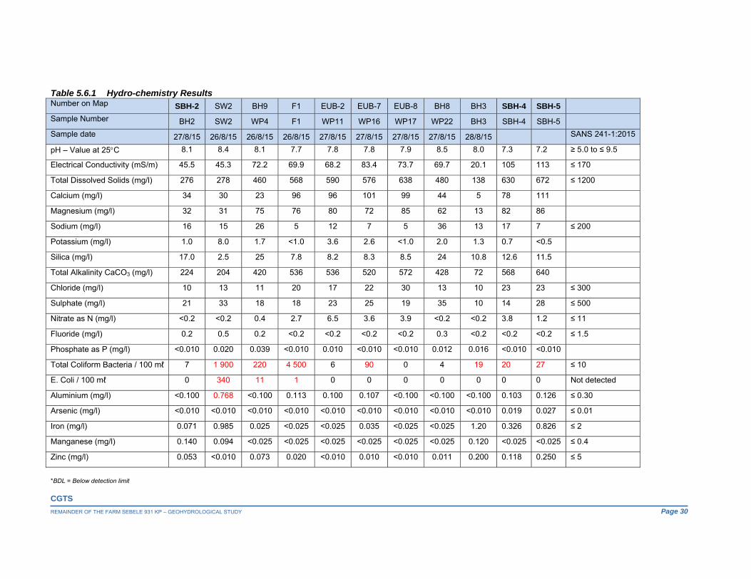
CGTS
REMAINDER OF THE FARM SEBELE 931 KP – GEOHYDROLOGICAL STUDY Page 30
Table 5.6.1 Hydro-chemistry Results
*BDL = Below detection limit
Number on Map SBH-2 SW2 BH9 F1 EUB-2 EUB-7 EUB-8 BH8 BH3 SBH-4 SBH-5
Sample Number BH2 SW2 WP4 F1 WP11 WP16 WP17 WP22 BH3 SBH-4 SBH-5
Sample date 27/8/15 26/8/15 26/8/15 26/8/15 27/8/15 27/8/15 27/8/15 27/8/15 28/8/15 SANS 241-1:2015
pH – Value at 25C 8.1 8.4 8.1 7.7 7.8 7.8 7.9 8.5 8.0 7.3 7.2 ≥ 5.0 to ≤ 9.5
Electrical Conductivity (mS/m) 45.5 45.3 72.2 69.9 68.2 83.4 73.7 69.7 20.1 105 113 ≤ 170
Total Dissolved Solids (mg/l) 276 278 460 568 590 576 638 480 138 630 672 ≤ 1200
Calcium (mg/l) 34 30 23 96 96 101 99 44 5 78 111
Magnesium (mg/l) 32 31 75 76 80 72 85 62 13 82 86
Sodium (mg/l) 16 15 26 5 12 7 5 36 13 17 7 ≤ 200
Potassium (mg/l) 1.0 8.0 1.7 <1.0 3.6 2.6 <1.0 2.0 1.3 0.7 <0.5
Silica (mg/l) 17.0 2.5 25 7.8 8.2 8.3 8.5 24 10.8 12.6 11.5
Total Alkalinity CaCO3 (mg/l) 224 204 420 536 536 520 572 428 72 568 640
Chloride (mg/l) 10 13 11 20 17 22 30 13 10 23 23 ≤ 300
Sulphate (mg/l) 21 33 18 18 23 25 19 35 10 14 28 ≤ 500
Nitrate as N (mg/l) <0.2 <0.2 0.4 2.7 6.5 3.6 3.9 <0.2 <0.2 3.8 1.2 ≤ 11
Fluoride (mg/l) 0.2 0.5 0.2 <0.2 <0.2 <0.2 <0.2 0.3 <0.2 <0.2 <0.2 ≤ 1.5
Phosphate as P (mg/l) <0.010 0.020 0.039 <0.010 0.010 <0.010 <0.010 0.012 0.016 <0.010 <0.010
Total Coliform Bacteria / 100 mℓ 7 1 900 220 4 500 6 90 0 4 19 20 27 ≤ 10
E. Coli / 100 mℓ 0 340 11 1 0 0 0 0 0 0 0 Not detected
Aluminium (mg/l) <0.100 0.768 <0.100 0.113 0.100 0.107 <0.100 <0.100 <0.100 0.103 0.126 ≤ 0.30
Arsenic (mg/l) <0.010 <0.010 <0.010 <0.010 <0.010 <0.010 <0.010 <0.010 <0.010 0.019 0.027 ≤ 0.01
Iron (mg/l) 0.071 0.985 0.025 <0.025 <0.025 0.035 <0.025 <0.025 1.20 0.326 0.826 ≤ 2
Manganese (mg/l) 0.140 0.094 <0.025 <0.025 <0.025 <0.025 <0.025 <0.025 0.120 <0.025 <0.025 ≤ 0.4
Zinc (mg/l) 0.053 <0.010 0.073 0.020 <0.010 0.010 <0.010 0.011 0.200 0.118 0.250 ≤ 5
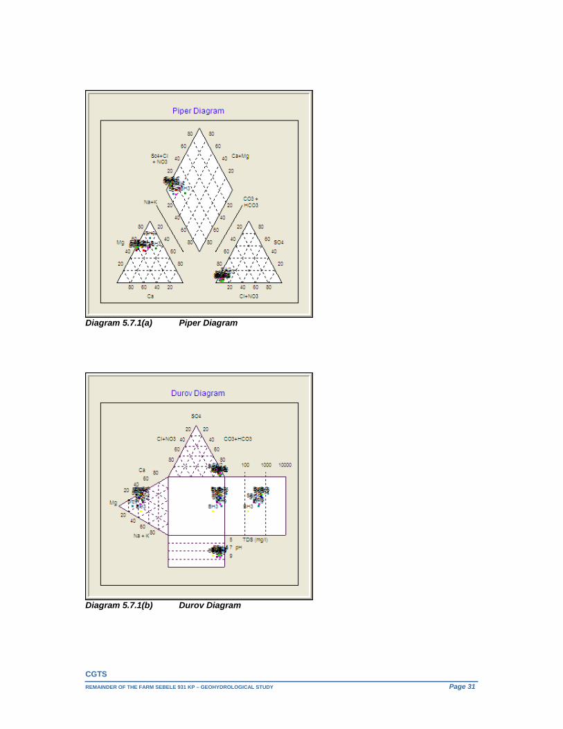
CGTS
REMAINDER OF THE FARM SEBELE 931 KP – GEOHYDROLOGICAL STUDY Page 31
Diagram 5.7.1(a) Piper Diagram
Diagram 5.7.1(b) Durov Diagram
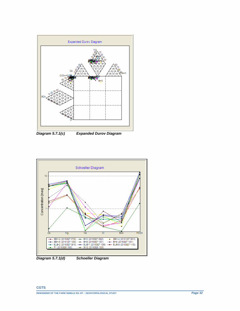
CGTS
REMAINDER OF THE FARM SEBELE 931 KP – GEOHYDROLOGICAL STUDY Page 32
Diagram 5.7.1(c) Expanded Durov Diagram
Diagram 5.7.1(d) Schoeller Diagram
CGTS
REMAINDER OF THE FARM SEBELE 931 KP – GEOHYDROLOGICAL STUDY Page 33
Diagram 5.7.1(e) SAR Diagram
The diagrams permit the cation and anion compositions of samples to be represented on single graphs in which major groupings or trends in the data can be discerned visually. The Schoeller diagram shows the total concentrations of the cations and anions whereas the tri-linear diagrams represent the concentrations as percentages. The SAR diagram rating of both the sodium and salinity hazard of water for irrigation purposes are applied in terms of crop yield and quality as well as potential soil contamination. The samples taken during the recent hydro-census all exhibit a magnesium bicarbonate character and plot as unpolluted on the Expanded Durov Diagram (Diagram 5.7.1(c)).
The dolomitic groundwater samples, (F1, SBH-5, EUB-2 & EUB-7), including the sample from borehole EUB-8 located immediately south of the dolomite / Timeball Hill Formation contact, as well as SBH-4 (farmhouse – Pretoria Group rocks) are grouped slightly apart from the rest of the samples.
The calcium concentrations of these samples are noticeable higher than that for the rest of the samples.
Interestingly the sample from the Marico River downstream from the Molatedi Dam wall (SW2) is grouped together with boreholes SBH-2, BH8 and BH9; between the aforementioned grouping and the sample from borehole BH3 which plots on its own, apart from these two groupings. Borehole BH3 is located in close proximity to the high water mark of the dam south of the quartzite ridge in quaternary catchment areas A32C.
Borehole SBH-2 is located some 85m west (up gradient) of the Marico River and 523m downstream from the Molatedi Dam wall. Borehole BH8 is located south of the quartzite ridge in quaternary catchment areas A32C some 85m above the dam’s high water mark, while borehole BH9 is located 183m south of the Brakfonteinspruit, roughly 1km west of the dam’s high water mark.
As can be seen in the SAR diagram all the samples are indicative of both a low sodium and salinity hazard.

CGTS
REMAINDER OF THE FARM SEBELE 931 KP – GEOHYDROLOGICAL STUDY Page 34
6. RESOURCE DIRECTED MEASURES The protocols associated with the Resource Directed Measures (RDM) as set out in publications such as DWAF (1999c) and Braune et.al. (2000) serves as reference methodology for this section and the preceding sections of this study.
6.1. Preliminary Classification of Groundwater Resource The present status category is determined by the extent to which the current groundwater environment has been modified from the reference (pristine) groundwater environment, which depends on factors such as the impact of groundwater usage on the sustainable utilisation of groundwater resources and the acceptability of associated environmental risks (e.g. reduction of baseflow and spring discharge, land subsidence and sinkhole development, etc.), as well as the impact of land uses on existing groundwater quality and potential or expected groundwater contamination. The resource classification in terms of category and class will be done in accordance to the criteria presented in Table 6.1 which is based on material presented in DWAF (1999b) and Braune et.al. (2000). Table 6.1 Groundwater Resource Classification Criteria.
PRESENT STATUS CATEGORY
WATER RESOURCE
CLASS
DISIRED STATUS CATEGORY
MANAGEMENT CLASS
A Unmodified; approximates natural conditions
Natural
A Highly sensitive systems, negligible risk allowed
Excellent
B Largely natural; few localised modifications, no negative impacts apparent
Good
B Sensitive systems, small risk allowed
Good
C Moderately modified; moderate changes apparent
Fair + Fair
Fair -
C Moderately sensitive systems, moderate risk allowed
Fair
D Largely modified; widespread loss of natural functioning
D Resilient systems, large risk allowed
E Seriously modified; loss of natural functioning extensive
Poor
F Critically modified; complete modification with near-complete loss of natural functioning
Table 6.2 Present Status Category and Water Resource Class
PRESENT STATUS CATEGORY ASSESSMENT CRITERIA & CONSIDERATIONS WATER RESOURCE
CLASSImpact Aspect Category Considerations and motivation
Water Use
C Small to possibly moderate groundwater use for domestic, stock and game watering as well as small scale irrigation. Dolomite RU (A32D) - Karst development is either absent or localised and borehole yields usually <2l/s – Minor Aquifer. Pta. Group RU (A32D) & (A32C) – Minor Aquifer. Variability of annual recharge, semi-arid region, recharge episodic in nature. Groundwater component of river baseflow (mean annual flow) is indicated as negligible
Fair +
Water Quality
C Although the groundwater is generally of an excellent quality (mostly within the SANS 241-1:2015 chemical numerical limits), nitrate enrichment is apparent in some of the samples. Microbiology generally does not comply with the specified numerical limit implying an unacceptable risk to human health.
Land Use Risk
C Conjunction of conservation (game lodges), moderate land uses (dry land cultivation and cattle farming). Pta. Group RU (A32D) & (A32C) - Aquifer with Low Susceptibility. Dolomite RU (A32D) - Aquifer with High Susceptibility.
Environment
C Low to moderate levels of localised impact s with low to moderate perceived impact on the environment.
The material presented in the preceding sections of this report with regard to the determination of the geohydrological response units, hydrostatic fluctuations and the comparison of current groundwater water levels and groundwater quality with reference information, provide sufficient geohydrological

CGTS
REMAINDER OF THE FARM SEBELE 931 KP – GEOHYDROLOGICAL STUDY Page 35
information with which to establish the present status categories and classes of the identified groundwater reserves. As can be seen in Table 6.2, based on the foregoing, the Sebele groundwater reserves / flow regimes are afforded “C” present status categories and “Fair +” water resource classes. In light of the proposed Sebele Lodge activities as well as the present resource classifications, the implementation of a monitoring programme and management plan that is supported by a well-informed set of resource quality objectives (RQOs – Section 6.3) is important.
6.2. Reserve Determination and Water Balance The EXCEL RECHARGE program (June 2000 version) developed by Gerrit van Tonder and Jongxin Xu of UOVS, supervised by Eddie van Wyk of DWAF (previously), was used for the groundwater reserve determinations.
The identified groundwater reserve flow regimes respectively encompass areas of 224km2, 105km2 and 36.5km2. Conservative recharge values of 1% of the mean annual precipitation (533.01mm/a - A32D and 526.47mm/a - A32C) were used which is towards the lower end of the typical mean annual recharge range for the area (5mm/a - 10mm/a of MAP), as indicated by the Groundwater Resources of the Republic of South Africa Map (Table 4.1, Section 4). Given the highly differential hydro-climatic conditions and hydrogeological environment in semi-arid regions, effective groundwater recharge events are episodic in nature and largely occur once in every five years (Van Wyk, 2010). Van Wyk (2010) also states that direct groundwater recharge estimations from local, short-term rainfall and groundwater re-bound stage hydrochemical data proposes a recharge value <2% in most flat lying, semi-arid regions, hence the conservative recharge estimations. According to the National Water Act, No 36 of 1998, a certain percentage of the available resources must be set aside to cater for the needs of the ecological reserve, i.e. base flow of streams. Although the regionally indicated groundwater component of river baseflow (mean annual flow) is indicated as negligible a conservative 35% of recharge was awarded to the respective ecological reserves. Table 6.3 Groundwater Reserve Determination
Groundwater Reserve Dolomite RU (A32D)
m3/a
Pta. Group RU (A32D)
m3/a
Pta. Group RU (A32C)
m3/a
Recharge = 1 193 942.00 559 660.500 192 161.550 Groundwater Abstraction(excluding Basic Human Need) = 15 512.500 4 380.000 1 825.000
Basic Human Need (BHN) from GW =
Ecology and IFR Requirement = 62 465.000 195 881.000 67 256.5425
Groundwater flux towards rivers = 62 465.000 195 881.000 67 256.5425
Groundwater outflow from area = 62 465.000 195 881.000 67 256.5425
Amount allowed to be intercepted from outflow 0 0 0
Groundwater Inflow into area = 0 0 0
Extra GW allocation possible = 353 802.400 163 518.500 57 648.465 As can be seen in Table 6.3, the preliminary groundwater reserve determinations, recharge plus groundwater inflow into the area and the amount allowed to be intercepted from outflow, less existing groundwater abstraction, including basic human need (BHN), the Ecology and IFR requirement as well as the groundwater outflow from the area, are all indicative of substantial extra possible groundwater allocations. In terms of overall sustainability comparisons are made in Table 6.4 between the existing external groundwater use, the proposed Sebele groundwater use, as well as the total future use in terms of the “Average Groundwater Harvest Potential” (lower range) across the different groundwater reserves as
CGTS
REMAINDER OF THE FARM SEBELE 931 KP – GEOHYDROLOGICAL STUDY Page 36
well as those portions of the Sebele property encompassed by them. Additionally the proposed Sebele use from the different groundwater reserves are also compared to the extra possible groundwater allocations determined for them. Table 6.4 Sebele Water Demand Sustainability Comparison Table
Groundwater Reserve Dolomite RU (A32D)
m3/a
Pta. Group RU (A32D)
m3/a
Pta. Group RU (A32C)
m3/a
Groundwater Reserve Area (km2) 224 105 36.5
Total Reserve AGEP (m3/a) 896 000 420 000 146 000
Existing Groundwater Use from Reserve (m3/a) 15 512.5 4 380 1 825
Extra GW allocation possible =` 353 802.4 163 518.5 57 648.465
Proposed Sebele Groundwater Usage (m3/a) 910.675 28 360.140 0
Total Existing & Proposed Use from Reserve (m3/a) 16 423.175 32 740.140 1 825
Existing & Proposed Future use as % of Reserve AGEP 1.83 7.80 1.25
Proposed Sebele Groundwater use as % of Extra possible GW Allocation 0.26 17.34 0.00
Sebele Property area across Groundwater Reserve (km2) 11.87 23.27 5.0 Sebele proportional property “General Authorisation” 45m³/hectare/annum (m3/a) 53 415 104 715 22 554
Sebele Property area as % of Groundwater Reserve (%) 5.30 22.16 13.73
Sebele proportional property AGEP lower range (m3/a) 47 480 93 080 20 000
Recharge (1%) on Sebele property (m3/a) 63 268.266 124 031.427 26323.500
Sebele proportional property AGEP (lower range) as % of Recharge on property 75.05 75.05 75.98
Proposed Sebele Groundwater Use as % of Recharge on Property (%) 1.44 22.87 0.00
Initial Regional Assessment ‐ Property Water Demand Category A A ‐
Proposed Sebele Groundwater Use as % of proportional property AGEP (lower range) 1.92 30.47 0.00
* AGEP - Average Groundwater Harvest Potential
6.3. Preliminary Groundwater Resource Quality Objectives
6.3.1 Groundwater Quantity Sustainable safe yields were determined (FC Method) for the all the proposed Sebele Lodge water supply boreholes including scheduled sustainable long-term abstraction rates. The drawdown at these abstraction points should not exceed the critical drawdown levels determined for them in Table 5.5 (65% of the AD value used, which is the specified maximum drawdown that should not be reached after abstracting water continuously from the borehole for a long time). 6.3.2 Groundwater Quality In determining resource quality objectives a balance must be sought between the need to protect and sustain water resources on the one hand, and the need to develop and use them on the other.

CGTS
REMAINDER OF THE FARM SEBELE 931 KP – GEOHYDROLOGICAL STUDY Page 37
The preliminary groundwater quality reserves are presented in Table 6.4 and entail the ambient groundwater quality values being compared with the Standard Limits, with the lesser values being escalated by 10%. The ambient groundwater quality was determined on the basis of the poorest qualities observed (Section 5.7). Table 6.4 Preliminary Groundwater Quality Reserve Determination
Determinand
Ambient Groundwater
Quality Pta Group
RU’s
Groundwater Quality Reserve
Pta Group RU’s
Ambient Groundwater
Quality Dolomite
RU
Groundwater Quality Reserve Dolomite
RU
SANS 241-1:2011
Standard Limits
pH – Value at 25C 8.5 ≥ 5.0 to ≤ 9.5 7.9 ≥ 5.0 to ≤ 9.5 ≥ 5.0 to ≤ 9.5 Electrical Conductivity (mS/m) 105 ≤ 115.500 113 ≤ 124.300 ≤ 170
Total Dissolved Solids (mg/l) 630 ≤ 693.000 672 ≤ 739.200 ≤ 1200
Calcium (mg/l) 78 ≤ 85.800 111 ≤ 122.100
Magnesium (mg/l) 82 ≤ 90.200 86 ≤ 94.600
Sodium (mg/l) 36 ≤ 39.600 12 ≤ 13.200 ≤ 200
Potassium (mg/l) 2 ≤ 2.200 3.6 ≤ 3.960
Silica (mg/l) 25 ≤ 27.500 11.5 ≤12.650 Total Alkalinity CaCO3 (mg/l) 568 ≤ 624.800 640 ≤ 704.000
Chloride (mg/l) 23 ≤ 25.300 ≤30 ≤ 33.000 ≤ 300
Sulphate (mg/l) 35 ≤ 38.500 28 ≤ 30.800 ≤ 500
Nitrate as N (mg/l) 3.8 ≤ 4.180 6.5 ≤ 7.150 ≤ 11
Fluoride (mg/l) 0.3 ≤ 0.330 0.2 ≤ 0.220 ≤ 1.5 Aluminium (mg/l) 0.103 ≤ 0.113 0.126 ≤0.139 ≤ 0.30 Antimony (mg/l) <0.01 <0.01 <0.01 <0.01 ≤ 0.02 Arsenic (mg/l) 0.019 ≤ 0.021 0.027 ≤ 0.030 ≤ 0.01 Barium (mg/l) 0.065 ≤ 0.072 <0.01 <0.01 ≤ 0.7 Boron (mg/l) 0.038 ≤ 0.042 0.01 ≤ 0.011 ≤ 2.4 Cadmium (mg/l) <0.01 <0.01 <0.01 <0.01 ≤ 0.003 Chromium (mg/l) <0.01 <0.01 <0.01 <0.01 ≤ 0.05 Cobalt (mg/l) <0.01 <0.01 <0.01 <0.01 ≤ 0.5 Copper (mg/l) 0.014 ≤ 0.015 <0.01 <0.01 ≤ 2 Iron (mg/l) 1.20 ≤ 1.320 0.826 ≤ 0.909 ≤ 2 Lead (mg/l) <0.01 <0.01 <0.01 <0.01 ≤ 0.01 Manganese (mg/l) 0.14 ≤ 0.154 <0.025 <0.025 ≤ 0.5 Mercury (mg/l) <0.01 <0.025 <0.01 <0.025 ≤ 0.006 Nickel (mg/l) 0.019 ≤ 0.021 0.028 ≤ 0.031 ≤ 0.07 Selenium (mg/l) <0.01 <0.01 <0.01 <0.01 ≤ 0.01 Silver (mg/l) <0.01 <0.01 <0.01 <0.01 Uranium (mg/l) <0.01 <0.01 <0.01 <0.01 ≤ 0.015 Vanadium (mg/l) 0.019 ≤ 0.021 <0.01 <0.01 ≤ 0.2 Zinc (mg/l) 0.2 ≤0.220 0.25 ≤ 0.275 ≤ 5
6.4. Proposed Future Management Class As can be seen in Table 6.1, the proposed management class is derived from the preliminary water resource class via the desired status category. As can be seen in Table 6.2, the Sebele groundwater reserves were afforded “C” present status categories and “Fair +” water resource classes. From this it is evident that the proposed desired status category and management class conforms to the preliminary water resource class, implying that no proposed desired status category and management class is higher than the preliminary water resource class.
CGTS
REMAINDER OF THE FARM SEBELE 931 KP – GEOHYDROLOGICAL STUDY Page 38
The Sebele groundwater reserves were thus afforded “C” desired category status’s with proposed “Fair” management class’s with the objectives in terms of both the groundwater quantity and quality specified in the foregoing section (Section 6.3), and the monitoring thereof being addressed in Section 9.2.
7. RISK ASSESSMENT The activities associated with the proposed Sebele Lodge development have been discussed in detail in Section 1 of this report. In this section the potential impacts associated with these activities are described, and where appropriate, ranked by a significance assessment methodology. The assessment of overall impact significance provides an indication of the extent to which the impacts either could have “no-go” implications for certain aspects of the activities or proposed activities or which of these will need to be countered by appropriate mitigation. This section will look holistically at the individual and integrated activities as well as at measures that are taken to mitigate any potential impact. After the significance of each impact was determined a rank was awarded to each impact.
7.1. Significance Assessment Methodology The significance of Environmental Impacts was assessed in accordance with the following method; Significance is the product of probability and severity. Probability describes the likelihood of the impact actually occurring, and is rated as follows: Improbable - Low possibility of impact to occur either because of design or historic experience. Rating = 2 Probable - Distinct possibility that impact will occur. Rating = 3 Highly probable - Most likely that impact will occur. Rating = 4 Definite - Impact will occur regardless of any prevention measures. Rating = 5 The severity rating is calculated from the factors given to intensity and duration. Intensity and duration factors are awarded to each impact, as described below. The Intensity factor is awarded to each impact according to the following method: Low intensity - nature and/or manmade functions not affected (minor process
damage or personnel injury may have occurred. Factor 1
Medium intensity - environment affected but natural and/or manmade functions and
processes continue (Some process damage or personnel injury may have occurred).
Factor 2 High intensity - environment affected to the extent that natural and/or manmade
functions are altered to the extent that it will temporarily or permanently cease (Major process damage or personnel injury may have occurred).
Factor 4 Duration is assessed and a factor awarded in accordance with the following:

CGTS
REMAINDER OF THE FARM SEBELE 931 KP – GEOHYDROLOGICAL STUDY Page 39
Short term - <1 to 5 years - Factor 2 Medium term - 5 to 15 years - Factor 3 Long term - impact will only cease after the operational life of the activity, either because of natural process
or by human intervention - Factor 4. Permanent - mitigation, either by natural process or by human intervention, will not
occur in such a way or in such a time span that the impact can be considered transient - Factor 5.
The severity rating is obtained from calculating a severity factor, and comparing the severity factor to the rating in the table below. For example: The Severity factor = Intensity factor X Duration factor = 2 x 3 = 6 A Severity factor of six (6) equals a Severity Rating of Medium severity (Rating 3) as per the table below:
Table 7.1. Severity Rating Rating FactorLow Severity (Rating 2) Calculated values 2 to 4 Medium Severity (Rating 3) Calculated values 5 to 8 High Severity (Rating 4) Calculated values 9 to 12 Very High severity (Rating 5) Calculated values 13 to 16 Severity factors below 3 indicate no impact
A Significance Rating is calculated by multiplying the Severity Rating with the Probability Rating. The significance rating should influence the activities / proposed activities as described below: Low significance (calculated Significance Rating 4 to 6)
o Positive impact and negative impacts of low significance should have no influence on the proposed development project.
Medium significance (calculated Significance Rating ≥ 7 to 12) o Positive impact:
Should weigh towards a decision to continue o Negative impact:
Should be mitigated before activity can be approved. High significance (calculated Significance Rating ≥ 13 to 18)
o Positive impact: Should weigh towards a decision to continue, should be enhanced in final design.
o Negative impact: Should weigh towards a decision to terminate proposal, or mitigation should be performed to reduce significance to at least low significance rating.
Very High significance (calculated Significance Rating ≥ 19 to 25) o Positive impact:
Continue definite. o Negative impact:
If mitigation cannot be effectively implemented, proposal should be terminated.
7.2. Assessments of Impacts The impacts associated with the proposed Sebele Lodge activities (Section 1) are summarised in Table 7.2 below. Cognisance are taken of the activities as they relate to the National Water Act, as well as the Resource Directed Measures (RDM) determined in the forgoing sections in terms of the preliminary resource classifications, resource quality objectives and future management classes.
CGTS
REMAINDER OF THE FARM SEBELE 931 KP – GEOHYDROLOGICAL STUDY Page 40
Table 7.2. Significance Assessment of the impacts identified, and mitigation plans for the proposed Sebele Lodge development. Aspect Possible
Impacts Significance of Impacts
Probability Significance rating Severity Factor
Severity Rating
Significance Rating
Mitigation Plan Responsible Person
Intensity Duration
1. Section 21(a) – Taking of water from a water resource Groundwater Quantity Groundwater Abstraction
Impact on neighbouring borehole yields and the identified RU’s and their ecological reserves
2 2 4 8 3 6 Low Small scale abstraction (<60% of recharge on property). Conservative recharge estimations for all three RU’s (1%). Positive groundwater reserve water balance with 35% of recharge allocated to the ecological reserve and significant, extra groundwater allocation possible in all three RU’s. Borehole sustainable safe yield determinations taking cognisance of other boreholes pumping at distance (FC Method). Drawdown at abstraction points should not exceed the critical drawdown determined for that position. The closest external user’s borehole to any of the proposed Sebele water supply boreholes is 3.02km. Routine monthly monitoring of water levels, weekly abstraction volumes and total monthly rainfall.
Sebele Manager
1. Section 21(a) – Taking of water from a water resource Groundwater Quantity Groundwater Abstraction
Land stability
2 2 4 8 3 6 Low The Malmani dolomite classifies as a Site Class “P” according to the NHBRC Standards and Guidelines (1999). The area investigated around the old Lotteringskop lodge, classifies as having an Inherent Hazard Class (IHC) of IHC2 which implies that there is a low to moderate potential for small sinkholes to develop in both a non-dewatering and dewatering scenario.
Sebele Manager
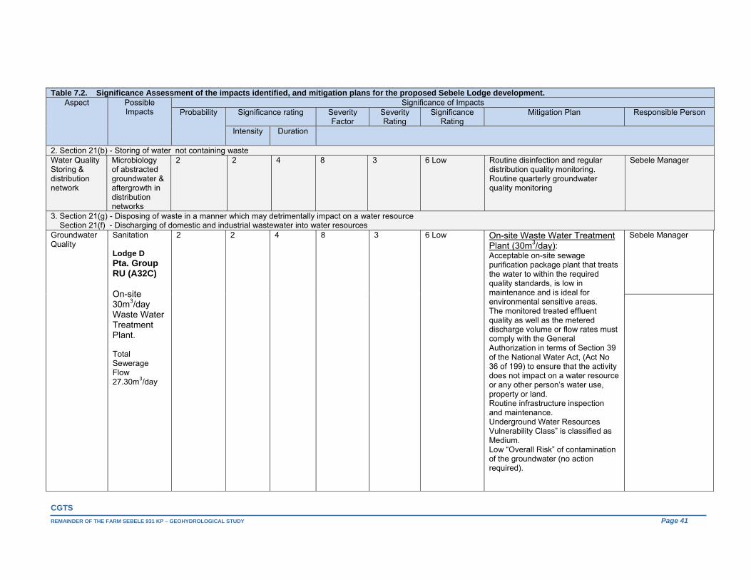
CGTS
REMAINDER OF THE FARM SEBELE 931 KP – GEOHYDROLOGICAL STUDY Page 41
Table 7.2. Significance Assessment of the impacts identified, and mitigation plans for the proposed Sebele Lodge development. Aspect Possible
Impacts Significance of Impacts
Probability Significance rating Severity Factor
Severity Rating
Significance Rating
Mitigation Plan Responsible Person
Intensity Duration
2. Section 21(b) - Storing of water not containing waste Water Quality Storing & distribution network
Microbiology of abstracted groundwater & aftergrowth in distribution networks
2 2 4 8 3 6 Low Routine disinfection and regular distribution quality monitoring. Routine quarterly groundwater quality monitoring
Sebele Manager
3. Section 21(g) - Disposing of waste in a manner which may detrimentally impact on a water resource Section 21(f) - Discharging of domestic and industrial wastewater into water resources Groundwater Quality
Sanitation Lodge D Pta. Group RU (A32C) On-site 30m3/day Waste Water Treatment Plant. Total Sewerage Flow 27.30m3/day
2 2 4 8 3 6 Low On-site Waste Water Treatment Plant (30m3/day): Acceptable on-site sewage purification package plant that treats the water to within the required quality standards, is low in maintenance and is ideal for environmental sensitive areas. The monitored treated effluent quality as well as the metered discharge volume or flow rates must comply with the General Authorization in terms of Section 39 of the National Water Act, (Act No 36 of 199) to ensure that the activity does not impact on a water resource or any other person’s water use, property or land. Routine infrastructure inspection and maintenance. Underground Water Resources Vulnerability Class” is classified as Medium. Low “Overall Risk” of contamination of the groundwater (no action required).
Sebele Manager
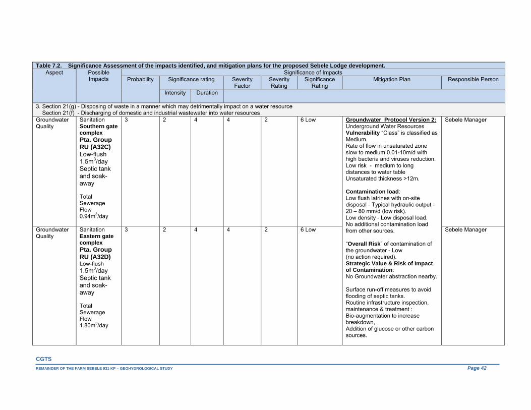
CGTS
REMAINDER OF THE FARM SEBELE 931 KP – GEOHYDROLOGICAL STUDY Page 42
Table 7.2. Significance Assessment of the impacts identified, and mitigation plans for the proposed Sebele Lodge development. Aspect Possible
Impacts Significance of Impacts
Probability Significance rating Severity Factor
Severity Rating
Significance Rating
Mitigation Plan Responsible Person
Intensity Duration
3. Section 21(g) - Disposing of waste in a manner which may detrimentally impact on a water resource Section 21(f) - Discharging of domestic and industrial wastewater into water resources Groundwater Quality
Sanitation Southern gate complex Pta. Group RU (A32C) Low-flush 1.5m3/day Septic tank and soak-away Total Sewerage Flow 0.94m3/day
3 2 4 4 2 6 Low Groundwater Protocol Version 2: Underground Water Resources Vulnerability “Class” is classified as Medium. Rate of flow in unsaturated zone slow to medium 0.01-10m/d with high bacteria and viruses reduction. Low risk - medium to long distances to water table Unsaturated thickness >12m. Contamination load: Low flush latrines with on-site disposal - Typical hydraulic output - 20 – 80 mm/d (low risk). Low density - Low disposal load. No additional contamination load from other sources. “Overall Risk” of contamination of the groundwater - Low (no action required). Strategic Value & Risk of Impact of Contamination: No Groundwater abstraction nearby. Surface run-off measures to avoid flooding of septic tanks. Routine infrastructure inspection, maintenance & treatment : Bio-augmentation to increase breakdown, Addition of glucose or other carbon sources.
Sebele Manager
Groundwater Quality
Sanitation Eastern gate complex Pta. Group RU (A32D) Low-flush 1.5m3/day Septic tank and soak-away Total Sewerage Flow 1.80m3/day
3 2 4 4 2 6 Low Sebele Manager
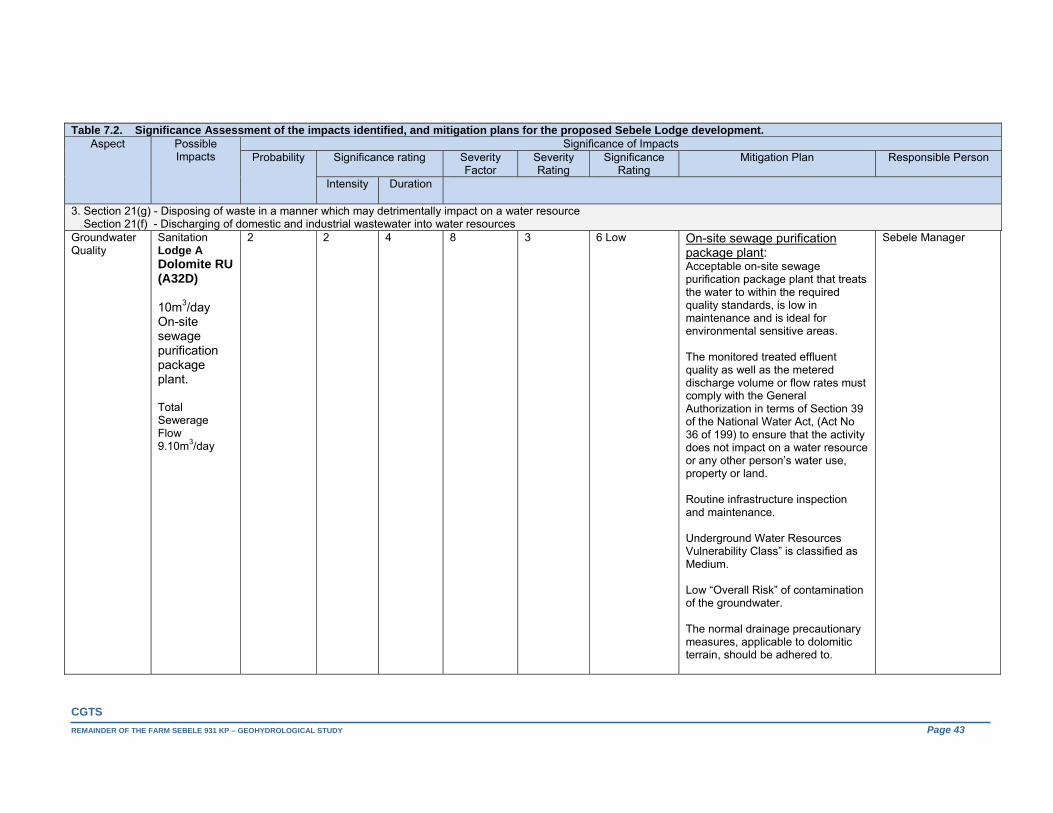
CGTS
REMAINDER OF THE FARM SEBELE 931 KP – GEOHYDROLOGICAL STUDY Page 43
Table 7.2. Significance Assessment of the impacts identified, and mitigation plans for the proposed Sebele Lodge development. Aspect Possible
Impacts Significance of Impacts
Probability Significance rating Severity Factor
Severity Rating
Significance Rating
Mitigation Plan Responsible Person
Intensity Duration
3. Section 21(g) - Disposing of waste in a manner which may detrimentally impact on a water resource Section 21(f) - Discharging of domestic and industrial wastewater into water resources Groundwater Quality
Sanitation Lodge A Dolomite RU (A32D) 10m3/day On-site sewage purification package plant. Total Sewerage Flow 9.10m3/day
2 2 4 8 3 6 Low On-site sewage purification package plant: Acceptable on-site sewage purification package plant that treats the water to within the required quality standards, is low in maintenance and is ideal for environmental sensitive areas. The monitored treated effluent quality as well as the metered discharge volume or flow rates must comply with the General Authorization in terms of Section 39 of the National Water Act, (Act No 36 of 199) to ensure that the activity does not impact on a water resource or any other person’s water use, property or land. Routine infrastructure inspection and maintenance. Underground Water Resources Vulnerability Class” is classified as Medium. Low “Overall Risk” of contamination of the groundwater. The normal drainage precautionary measures, applicable to dolomitic terrain, should be adhered to.
Sebele Manager
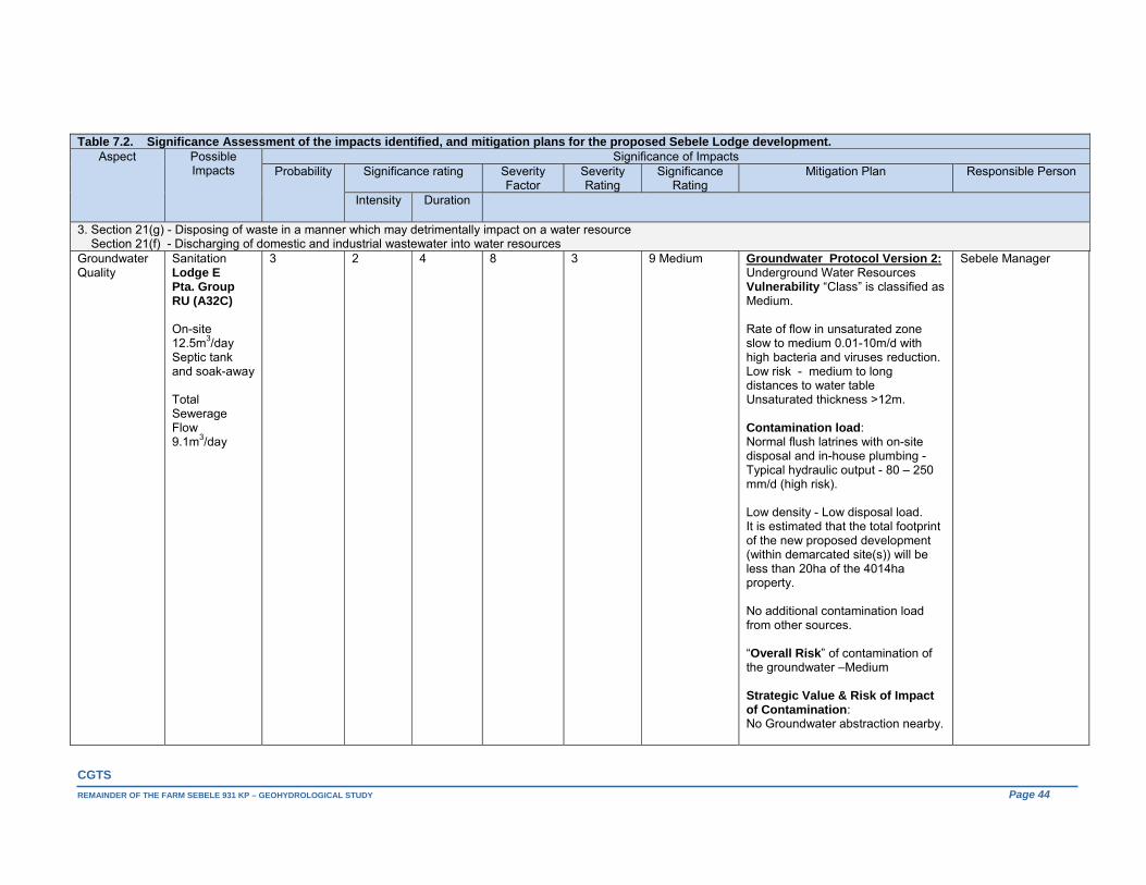
CGTS
REMAINDER OF THE FARM SEBELE 931 KP – GEOHYDROLOGICAL STUDY Page 44
Table 7.2. Significance Assessment of the impacts identified, and mitigation plans for the proposed Sebele Lodge development. Aspect Possible
Impacts Significance of Impacts
Probability Significance rating Severity Factor
Severity Rating
Significance Rating
Mitigation Plan Responsible Person
Intensity Duration
3. Section 21(g) - Disposing of waste in a manner which may detrimentally impact on a water resource Section 21(f) - Discharging of domestic and industrial wastewater into water resources Groundwater Quality
Sanitation Lodge E Pta. Group RU (A32C) On-site 12.5m3/day Septic tank and soak-away Total Sewerage Flow 9.1m3/day
3 2 4 8 3 9 Medium Groundwater Protocol Version 2: Underground Water Resources Vulnerability “Class” is classified as Medium. Rate of flow in unsaturated zone slow to medium 0.01-10m/d with high bacteria and viruses reduction. Low risk - medium to long distances to water table Unsaturated thickness >12m. Contamination load: Normal flush latrines with on-site disposal and in-house plumbing - Typical hydraulic output - 80 – 250 mm/d (high risk). Low density - Low disposal load. It is estimated that the total footprint of the new proposed development (within demarcated site(s)) will be less than 20ha of the 4014ha property. No additional contamination load from other sources. “Overall Risk” of contamination of the groundwater –Medium Strategic Value & Risk of Impact of Contamination: No Groundwater abstraction nearby.
Sebele Manager

CGTS
REMAINDER OF THE FARM SEBELE 931 KP – GEOHYDROLOGICAL STUDY Page 45
Table 7.2. Significance Assessment of the impacts identified, and mitigation plans for the proposed Sebele Lodge development. Aspect Possible
Impacts Significance of Impacts
Probability Significance rating Severity Factor
Severity Rating
Significance Rating
Mitigation Plan Responsible Person
Intensity Duration
3. Section 21(g) - Disposing of waste in a manner which may detrimentally impact on a water resource Section 21(f) - Discharging of domestic and industrial wastewater into water resources Groundwater Quality
Sanitation Lodge E Pta. Group RU (A32C) On-site 12.5m3/day Septic tank and soak-away Total Sewerage Flow 9.1m3/day
At distance 695m up gradient from nearest surface water source high water mark Precautionary Measures: Geotechnical investigation and design as per SABS Code 0400-1990 Surface run-off measures to avoid flooding of septic tanks. Routine infrastructure inspection, maintenance & treatment : Bio-augmentation to increase breakdown, Addition of glucose or other carbon sources.
Sebele Manager
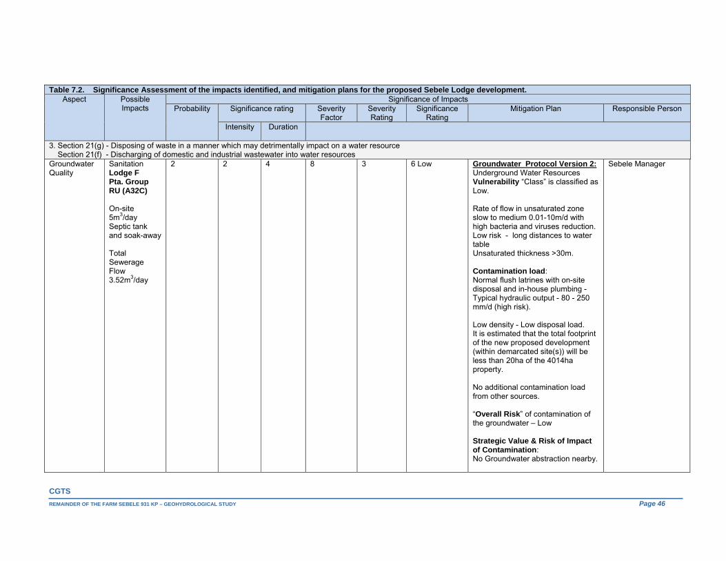
CGTS
REMAINDER OF THE FARM SEBELE 931 KP – GEOHYDROLOGICAL STUDY Page 46
Table 7.2. Significance Assessment of the impacts identified, and mitigation plans for the proposed Sebele Lodge development. Aspect Possible
Impacts Significance of Impacts
Probability Significance rating Severity Factor
Severity Rating
Significance Rating
Mitigation Plan Responsible Person
Intensity Duration
3. Section 21(g) - Disposing of waste in a manner which may detrimentally impact on a water resource Section 21(f) - Discharging of domestic and industrial wastewater into water resources Groundwater Quality
Sanitation Lodge F Pta. Group RU (A32C) On-site 5m3/day Septic tank and soak-away Total Sewerage Flow 3.52m3/day
2 2 4 8 3 6 Low Groundwater Protocol Version 2: Underground Water Resources Vulnerability “Class” is classified as Low. Rate of flow in unsaturated zone slow to medium 0.01-10m/d with high bacteria and viruses reduction. Low risk - long distances to water table Unsaturated thickness >30m. Contamination load: Normal flush latrines with on-site disposal and in-house plumbing - Typical hydraulic output - 80 - 250 mm/d (high risk). Low density - Low disposal load. It is estimated that the total footprint of the new proposed development (within demarcated site(s)) will be less than 20ha of the 4014ha property. No additional contamination load from other sources. “Overall Risk” of contamination of the groundwater – Low Strategic Value & Risk of Impact of Contamination: No Groundwater abstraction nearby.
Sebele Manager

CGTS
REMAINDER OF THE FARM SEBELE 931 KP – GEOHYDROLOGICAL STUDY Page 47
Table 7.2. Significance Assessment of the impacts identified, and mitigation plans for the proposed Sebele Lodge development. Aspect Possible
Impacts Significance of Impacts
Probability Significance rating Severity Factor
Severity Rating
Significance Rating
Mitigation Plan Responsible Person
Intensity Duration
3. Section 21(g) - Disposing of waste in a manner which may detrimentally impact on a water resource Section 21(f) - Discharging of domestic and industrial wastewater into water resources Groundwater Quality
Sanitation Lodge F Pta. Group RU (A32C) On-site 5m3/day Septic tank and soak-away Total Sewerage Flow 3.52m3/day
At distance 1,000m up gradient from nearest surface water source high water mark Precautionary Measures: Geotechnical investigation and design as per SABS Code 0400-1990. [Increase soak-away footprint if soil profile insufficient, seal large open fractures, Install fine sand filter. Surface run-off measures to avoid flooding of septic tanks.] Routine infrastructure inspection, maintenance & treatment : Bio-augmentation to increase breakdown, Addition of glucose or other carbon sources.
Sebele Manager
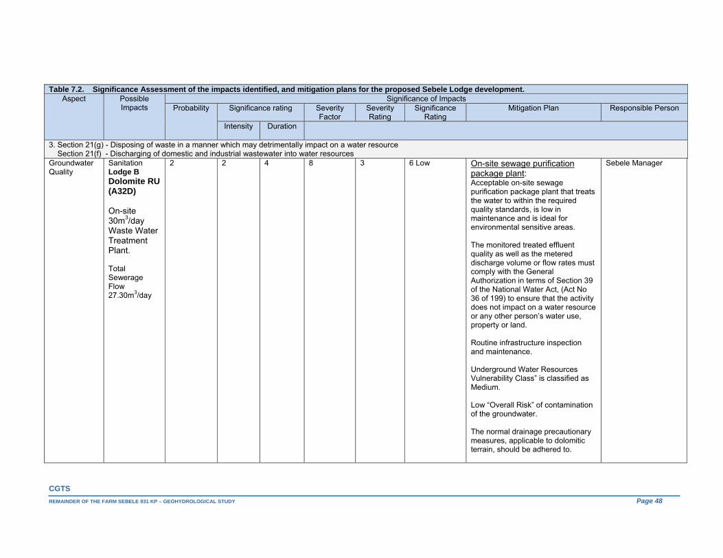
CGTS
REMAINDER OF THE FARM SEBELE 931 KP – GEOHYDROLOGICAL STUDY Page 48
Table 7.2. Significance Assessment of the impacts identified, and mitigation plans for the proposed Sebele Lodge development. Aspect Possible
Impacts Significance of Impacts
Probability Significance rating Severity Factor
Severity Rating
Significance Rating
Mitigation Plan Responsible Person
Intensity Duration
3. Section 21(g) - Disposing of waste in a manner which may detrimentally impact on a water resource Section 21(f) - Discharging of domestic and industrial wastewater into water resources Groundwater Quality
Sanitation Lodge B Dolomite RU (A32D) On-site 30m3/day Waste Water Treatment Plant. Total Sewerage Flow 27.30m3/day
2 2 4 8 3 6 Low On-site sewage purification package plant: Acceptable on-site sewage purification package plant that treats the water to within the required quality standards, is low in maintenance and is ideal for environmental sensitive areas. The monitored treated effluent quality as well as the metered discharge volume or flow rates must comply with the General Authorization in terms of Section 39 of the National Water Act, (Act No 36 of 199) to ensure that the activity does not impact on a water resource or any other person’s water use, property or land. Routine infrastructure inspection and maintenance. Underground Water Resources Vulnerability Class” is classified as Medium. Low “Overall Risk” of contamination of the groundwater. The normal drainage precautionary measures, applicable to dolomitic terrain, should be adhered to.
Sebele Manager

CGTS
REMAINDER OF THE FARM SEBELE 931 KP – GEOHYDROLOGICAL STUDY Page 49
Table 7.2. Significance Assessment of the impacts identified, and mitigation plans for the proposed Sebele Lodge development. Aspect Possible
Impacts Significance of Impacts
Probability Significance rating Severity Factor
Severity Rating
Significance Rating
Mitigation Plan Responsible Person
Intensity Duration
3. Section 21(g) - Disposing of waste in a manner which may detrimentally impact on a water resource Section 21(f) - Discharging of domestic and industrial wastewater into water resources Groundwater Quality
Sanitation Lodge C Pta. Group RU (A32C) On-site 5m3/day Septic tank and soak-away Total Sewerage Flow 3.52m3/day
2 2 4 8 3 6 Low Groundwater Protocol Version 2: Underground Water Resources Vulnerability “Class” is classified as Low. Rate of flow in unsaturated zone slow to medium 0.01-10m/d with high bacteria and viruses reduction. Low risk - long distances to water table Unsaturated thickness >30m. Contamination load: Normal flush latrines with on-site disposal and in-house plumbing - Typical hydraulic output - 80 - 250 mm/d (high risk). Low density - Low disposal load. It is estimated that the total footprint of the new proposed development (within demarcated site(s)) will be less than 20ha of the 4014ha property. No additional contamination load from other sources. “Overall Risk” of contamination of the groundwater – Low Strategic Value & Risk of Impact of Contamination: No Groundwater abstraction nearby.
Sebele Manager

CGTS
REMAINDER OF THE FARM SEBELE 931 KP – GEOHYDROLOGICAL STUDY Page 50
Table 7.2. Significance Assessment of the impacts identified, and mitigation plans for the proposed Sebele Lodge development. Aspect Possible
Impacts Significance of Impacts
Probability Significance rating Severity Factor
Severity Rating
Significance Rating
Mitigation Plan Responsible Person
Intensity Duration
3. Section 21(g) - Disposing of waste in a manner which may detrimentally impact on a water resource Section 21(f) - Discharging of domestic and industrial wastewater into water resources Groundwater Quality
Sanitation Lodge C Pta. Group RU (A32C) On-site 5m3/day Septic tank and soak-away Total Sewerage Flow 3.52m3/day
2 2 4 8 3 6 Low At distance 500m up gradient from nearest surface water source high water mark Precautionary Measures: Geotechnical investigation and design as per SABS Code 0400-1990. [Increase soak-away footprint if soil profile insufficient, seal large open fractures, Install fine sand filter. Surface run-off measures to avoid flooding of septic tanks.] Routine infrastructure inspection, maintenance & treatment : Bio-augmentation to increase breakdown, Addition of glucose or other carbon sources.
Sebele Manager

CGTS
REMAINDER OF THE FARM SEBELE 931 KP – GEOHYDROLOGICAL STUDY Page 51
The Department of Water Affairs & Forestry’s “PROTOCOL TO MANAGE THE POTENTIAL OF GROUNDWATER CONTAMINATION FROM ON SITE SANITATION, National Sanitation Co-ordination Office, Directorate of Geohydrology, Edition 2, 2003” was used to evaluate the risk of groundwater contamination from on-site sanitation.
None of the proposed activities assessed indicated “no-go” implications and in conclusion it can be stated that should the listed mitigation measures and current facility and activity management class be adhered to and maintained, the risk that the proposed Sebele development will pose to the identified groundwater reserves, the environment or any other person’s water use is regarded as low.
8. CONCLUSIONS The 4,014ha Sebele property is straddled by the water divide between quaternary catchment areas A32C and A32D, with the portion across the latter consisting of two Resource Units (RU) of which one (the Northern Dolomite Outcrop) can possible be further divided due to compartmentalization. In both Quaternary Catchment areas A32C and A32D, the conditional abstraction of groundwater is permitted under a “General Authorisation” up to a maximum of 45m³/hectare/annum. As far as the property in question is concerned this figure translates to 495m3/day (61.8m3/d - A32C & 433.2m3/day A32D). The total maximum water demand determined for the proposed Sebele development is 76.920m3/day or 28,075.800m3/annum. The initial regional assessment of the water demand on the different portions of the 4,014ha property as they pertain to the identified groundwater reserves all calculate to Category A or small scale abstractions (<60% of recharge on the individual parts of the property). The water demand is to be met from groundwater through one existing borehole, SBH-2; and two newly commissioned boreholes, namely SBH-4 and SBH-5. Preliminary groundwater reserve determinations, recharge plus groundwater inflow into the area and the amount allowed to be intercepted from outflow, less existing groundwater abstraction, including basic human need (BHN), the Ecology and IFR requirement as well as the groundwater outflow from the area, are all indicative of substantial extra possible groundwater allocations. Although the regionally indicated groundwater component of river baseflow (mean annual flow) is indicated as negligible, a conservative 35% of recharge (conservative 1%) was awarded to the respective ecological reserves. Both boreholes SBH-2 and SBH-4 are located within the 105km2 identified groundwater reserve / flow regime pertaining to the Pretoria Group RU (A32D) to the west of the Marico River, south of the Malmani dolomite contact (Northern Dolomite Outcrop). The recommended sustainable long-term combined abstraction rate for the two proposed water supply boreholes located within the Pretoria Group RU (A32D) groundwater reserve west of the Marico River is some 2.70L/sec (9.712375m3/hr) for a maximum of 8 hours/day (77.699m3/day or 28,360.140m3/annum). The Sebele property area (23.27km2) across the identified Pretoria Group RU (A32D) groundwater reserve makes up some 22.16% of this reserve. The proposed Sebele groundwater use from this reserve calculates to 17.34% of the extra possible groundwater allocation from the reserve. The proposed Sebele groundwater use from boreholes SBH-2 and SBH-4 calculates to 30.47% of the Average Groundwater Harvest Potential (AGEP – lower range) available from the Sebele property area across this groundwater reserve. The initial regional assessment of the water demand on this portion of the property (22.87% of recharge on this portion of the property) calculates to a Category A or small scale abstraction (<60% of recharge on property). As far as the identified (A32D) Pretoria Group RU groundwater reserve is concerned, the closest external user’s boreholes, EUB-8 (Genadendal 116 KP/1) and EUB-9 are located respectively some 3.27km and 3.63km to the northwest and west of proposed water supply borehole SBH-4, while borehole SBH-2 is located some 4.5km southwest of the centre of “Molatedi Village”. As previously stated the Molatedi cluster is supplied with water via a small Water Treatment Works (WTW) located at the Molatedi Dam with a design capacity of 0.183Mm3/annum (SRK, 2011). The available data points from the GRIP database indicate two working boreholes in Molatedi Village. One

CGTS
REMAINDER OF THE FARM SEBELE 931 KP – GEOHYDROLOGICAL STUDY Page 52
of these has an observed discharge rate of 0.56l/s. The Village wasn’t covered during the recent hydro-census as access could not be obtained. Apart from the Marico River, all the intermittent streams surveyed were observed to be dry. Borehole SBH-5 is located within the 224km2 identified groundwater reserve pertaining to the already mentioned Malmani dolomite RU. The recommended sustainable long-term abstraction rate for the proposed water supply borehole located within the Malmani dolomite RU is 0.09L/sec (0.311875m3/hr) for a maximum of 8 hours/day (2.495m3/day). The Sebele property area (11.87km2) across the identified Malmani dolomite RU (A32D) groundwater reserve makes up some 5.3% of this reserve. The proposed Sebele groundwater use from this reserve calculates to 0.26% of the extra possible groundwater allocation from this reserve. The proposed Sebele groundwater use from borehole SBH-5 calculates to 1.92% of the Average Groundwater Harvest Potential (AGEP - lower limit) available from the Sebele property area across this groundwater reserve. The initial regional assessment of the water demand on this portion of the property (1.92% of recharge on this portion of the property) calculates to a Category A or small scale abstraction (<60% of recharge on property). In terms of the Malmani dolomite RU, the closest external user’s borehole, EUB-10 (Tweedepoort 110KP) is located some 4.1km to the northwest of the proposed water supply borehole for Lotteringskop namely borehole SBH-5. No flow was observed at the fountain at Lotteringskop, only ponding. The observed water level elevation for borehole SBH-5 is some 27.65m lower than that of the dug well next to the Lotteringskop fountain (F1), suggesting that the intermittent fountain discharge here can probably be associated with the kopje’s regolith itself. The combined sustainable safe yield of the three (3) aquifer tested boreholes calculates to 80.194m3/day, meeting the demand with 3.274m3/day spare capacity. Although peak occupancy can be expected over certain times of the year the average annual occupancy levels should / will probably be in the region of 70%. As far as back up provision and overall water security is concerned, large track of land remains unexplored allowing not only suitable spacing of potential additional / future production boreholes but also ample capacity in terms of availability under “General Authorizations’”, the significant extra groundwater allocations possible from the identified groundwater reserves (even after provision for the proposed Sebele development), as well as what is left of the indicated Average Groundwater Harvest Potential (lower limits) as pertaining to the different portions of the property as they related to the mentioned reserves. Two geophysical drill sites pertaining to the identified Pretoria Group Resource Unit (A32C) groundwater reserve remain unexplored. Approximately 5.0m3/day is being abstracted (BH8 - BCPA) from the identified Pretoria Group Resource Unit (A32C) / Groundwater Reserve. Outside and along the southern boundary of this reserve, immediate south of the Brakfontein Spruit, some 33m3/day is being abstracted from borehole BH9 for cattle watering. This borehole also supplies the Mokgolo Lodge with water. The extra possible groundwater allocation from this 36.5km2 groundwater reserve calculates to 57,648.465m3/annum. The Average Groundwater Harvest Potential (AGEP lower limit) across the Sebele property encompassed by this groundwater reserve amounts to 20,000m3/annum or 54.795m3/day. Apart from the insufficient data, the average observed water level elevation pertaining to the dolomite lithological unit across quaternary catchment area A32D is higher than that observed for the overlying Pretoria Group sediments to the south (same quaternary catchment area – identified Pretoria Group RU (A32D)). It is also noteworthy that the borehole depths observed during the recent hydro-census, for a number of the now dysfunctional (historically existing) boreholes (Pretoria Group RU (A32D)) were above the recently observed depth to water level measurements recorded and the inferred water level depths at these localities. The water level elevations observed (October 2015) for both boreholes SBH-2 (931.25mamsl) and SBH-4 (927.25mamsl) are lower than the Marico River’s elevation (935mamsl - 934mamsl) scaled from the 5m flow contour data, indicating the river to be influent (see comments on hydro-chemical imaging) across the Pretoria Group RU (A32D). Contrastingly, the October 2015 groundwater elevation observed for borehole SBH-5 (Lotteringskop) is 953mamsl or some 18m – 23m above the Marico River’s terrain elevation across the dolomite RU at distance 2.4km to 4.8km east of this borehole.
CGTS
REMAINDER OF THE FARM SEBELE 931 KP – GEOHYDROLOGICAL STUDY Page 53
Also, in light of the absence of Hydstra platform data pertaining to hydrostatic fluctuations, mention is made here, that given the highly differential hydro-climatic conditions and hydrogeological environment in semi-arid regions, effective groundwater recharge events are episodic in nature and largely occur once in every five years (Van Wyk, 2010).
The correlation between the observed water levels and surface topography is poor and the water level measurements across the larger area are insufficient to draw concrete conclusions on the directions of groundwater flow. None the less, some groundwater baseflow contribution can be expected along the Marico River’s intersection (total drainage length some 11km) of the Malmani dolomite resource unit, as it represents the lowest terrain (<930mamsl to 935mamsl) across this lithological unit’s distribution within quaternary catchment area A32D. The regional groundwater flow vectors across the identified Malmani dolomite RU groundwater reserve is thus expected to be towards the Marico River. Additionally the natural groundwater flow directions for both the identified Pretoria Group RU’s are also, none the less, to a large extent expected to mirror the surface topography.
The 1:6 000 000 Map, Aquifer Classification of South Africa’s Susceptibility Matric [Minor aquifer vs. Least & Most Vulnerability ratings] is indicative of a Low Susceptibility for the Pretoria Group RU’s and a High Susceptibility for the dolomitic RU.
The samples taken during the recent hydro-census and aquifer testing programme all exhibit a magnesium bicarbonate character and plot as unpolluted on the hydro-chemical diagrams. Hydro-chemical imaging is further indicative of three distinguished groupings. The samples from the Marico River (SW2) and borehole SBH-2 display the same hydro-chemical fingerprint in one of these groupings.
Although the water is chemically generally of an excellent quality (mostly within the SANS 241-1:2015 chemical numerical limits), nitrate enrichment is apparent in some of the samples (F1, EUB-2, 7, 8 & SBH-4). The observed bacterial presence in the water makes continuously disinfection advisable. Routine water quality monitoring is also imperative.
All three of the Sebele groundwater reserves / flow regimes were afforded a “C” present status category and “Fair +” water resource class. Additionally they were also afforded a “C” Desired Category Status with a proposed “Fair” Management Class. Preliminary Groundwater Resource Quality Objectives include quantity objectives recommending the drawdown at the proposed abstraction points not to exceed the determined critical drawdown for these points, as well as a preliminary groundwater quality reserves that entails the ambient groundwater quality values being compared with the SANS 241-1:2015 Standard Limits, with the lesser values being escalated by 10%; and the monitoring of these objectives. None of the current or proposed Sebele activities assessed indicated “no-go” implications and in conclusion it can be stated that should the listed mitigation measures, Desired Category Status and Management Class be adhered to and maintained, the risk that the proposed Sebele operation will pose to humans and the environment is regarded as low. The proposed monitoring system design which is supported by a well-informed set of resource quality objectives should serve as sufficiently early implementation of corrective/preventative measures or where necessary, the setting of new objectives.
CGTS
REMAINDER OF THE FARM SEBELE 931 KP – GEOHYDROLOGICAL STUDY Page 54
9. RECOMMENDATIONS
9.1. Mitigation Measures Mitigation measures are tabled with the identified and rated impacts in Table 7.2. Apart of highlighting the more important ones in terms of the application for water use authorization, for the sake of repetitiveness, the others will not be repeated here: Drawdown at the abstraction points should not reach the critical drawdown determined for that
position; The boreholes are to be equipped with measuring tubes or “piezometers” to facilitate unhampered
water level measurements; All the water supply boreholes are to be equipped with flow meters to record abstraction volumes; It is recommended that all the water supply boreholes be provided with a concrete collar /slab at
surface during the completion of the equipping phase; The observed bacterial presence, although not all outright noncompliant with the specified SANS
numerical limits implies an unacceptable risk to human health. Sterilization and routine quality monitoring is a given;
In light of the proposed Sebele Lodge development activities, as well as the present resource classifications, the implementation of a monitoring programme and management plan that is supported by a well-informed set of resource quality objectives is important;
Establish monitoring points to monitor the treated effluent quality as well as the metered discharge volume or flow rates from any on-site sewage purification package plants which must comply with the General Authorization in terms of Section 39 of the National Water Act, (Act No 36 of 199) to ensure that the activity does not impact on a water resource or any other person’s water use, property or land;
Establish monitoring points to monitor the stored groundwater & aftergrowth in distribution networks;
Assimilation of monthly water level measurements, abstraction volumes as well as rainfall data into either the saturated volume fluctuation method (SVF) or the cumulative rainfall departure (CRD) method, is additionally recommended as an on-going predictive management tool in terms of groundwater reserve protection, as both are acceptable for simulating the water level response of an aquifer in a simple yet effective way because they reflect the water balance on an integrated basis;
In terms of backup and water security it is recommended that the indicated 3.274m3/day spare capacity be supplemented through the commissioning of additional suitable spaced water supply boreholes.
Ensure legal compliance in terms of registration etc.
9.2. Environmental Monitoring Programme Formal or procedural aspects of sampling are strictly controlled in terms of current legislation. This includes not only authorisation, permit, license and exemption conditions but also encompasses certain statutory provisions. These legal parameters have been integrated into the proposed monitoring protocol described below.
The following general comments relate to the proposed monitoring system design which is supported by a well-informed set of resource quality objectives (RQOs – Section 6.3):
Dedicated monitoring points are proposed in Table 9.1.
Sampling methodology: o GPS coordinates are to be taken at all the proposed monitoring points so that the samples can
be taken at the same place with each succeeding monitoring event. o The monitoring boreholes are to be sampled under application conditions, preferably before
entering any containment structures. Monthly water level measurements and weekly metered abstraction volumes are to be recorded. It is recommended that total monthly rainfall records be kept as well.
o Grab samples are to be taken at the rest of the sampling localities just below the water surface. Stage height or dam level measurements, stream flow estimation /description are to be recorded.
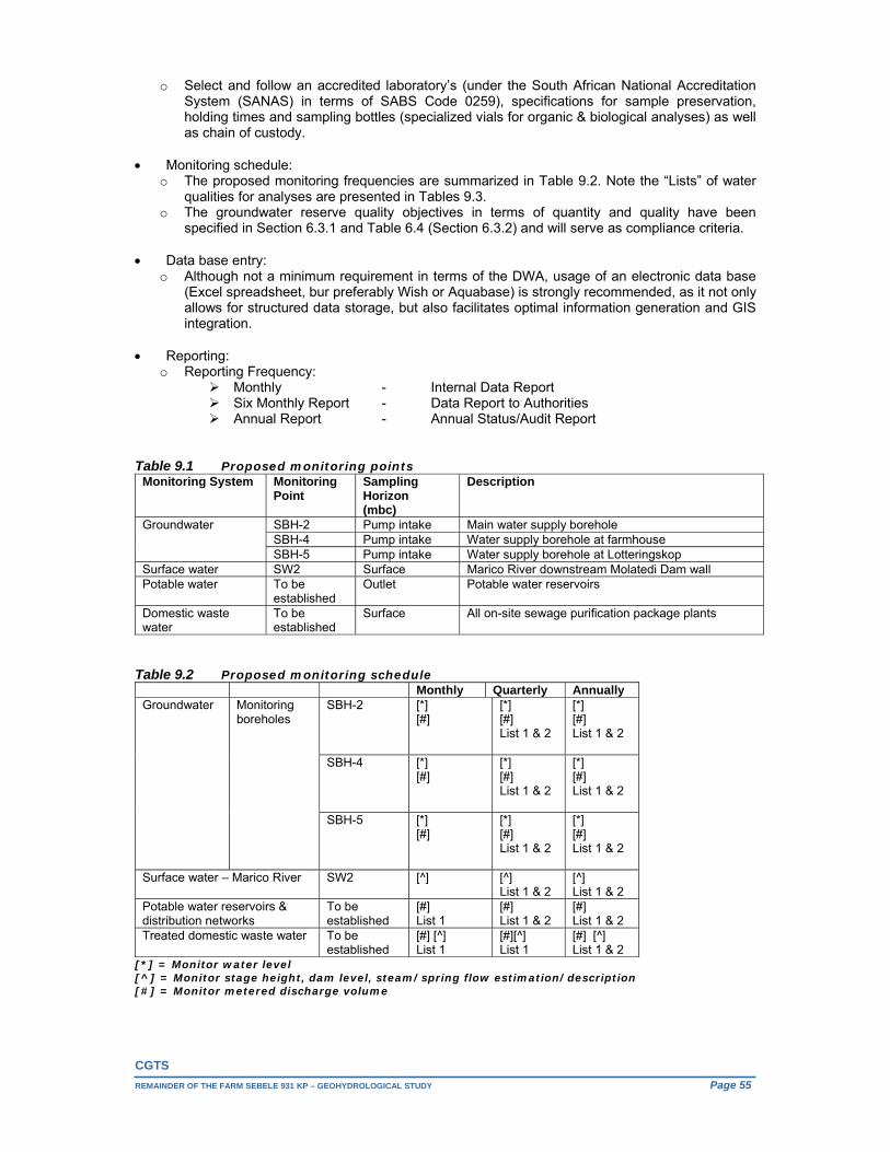
CGTS
REMAINDER OF THE FARM SEBELE 931 KP – GEOHYDROLOGICAL STUDY Page 55
o Select and follow an accredited laboratory’s (under the South African National Accreditation System (SANAS) in terms of SABS Code 0259), specifications for sample preservation, holding times and sampling bottles (specialized vials for organic & biological analyses) as well as chain of custody.
Monitoring schedule: o The proposed monitoring frequencies are summarized in Table 9.2. Note the “Lists” of water
qualities for analyses are presented in Tables 9.3. o The groundwater reserve quality objectives in terms of quantity and quality have been
specified in Section 6.3.1 and Table 6.4 (Section 6.3.2) and will serve as compliance criteria.
Data base entry: o Although not a minimum requirement in terms of the DWA, usage of an electronic data base
(Excel spreadsheet, bur preferably Wish or Aquabase) is strongly recommended, as it not only allows for structured data storage, but also facilitates optimal information generation and GIS integration.
Reporting: o Reporting Frequency:
Monthly - Internal Data Report Six Monthly Report - Data Report to Authorities Annual Report - Annual Status/Audit Report
Table 9.1 Proposed monitoring points
Monitoring System Monitoring Point
Sampling Horizon (mbc)
Description
Groundwater SBH-2 Pump intake Main water supply borehole SBH-4 Pump intake Water supply borehole at farmhouse SBH-5 Pump intake Water supply borehole at Lotteringskop
Surface water SW2 Surface Marico River downstream Molatedi Dam wall Potable water To be
established Outlet Potable water reservoirs
Domestic waste water
To be established
Surface All on-site sewage purification package plants
Table 9.2 Proposed monitoring schedule
Monthly Quarterly Annually Groundwater Monitoring
boreholes SBH-2
[*] [#]
[*] [#] List 1 & 2
[*] [#] List 1 & 2
SBH-4
[*] [#]
[*] [#] List 1 & 2
[*] [#] List 1 & 2
SBH-5 [*] [#]
[*] [#] List 1 & 2
[*] [#] List 1 & 2
Surface water – Marico River SW2 [^]
[^] List 1 & 2
[^] List 1 & 2
Potable water reservoirs & distribution networks
To be established
[#] List 1
[#] List 1 & 2
[#] List 1 & 2
Treated domestic waste water To be established
[#] [^] List 1
[#][^] List 1
[#] [^] List 1 & 2
[*] = Monitor water level [^] = Monitor stage height, dam level, steam/spring flow estimation/description [#] = Monitor metered discharge volume
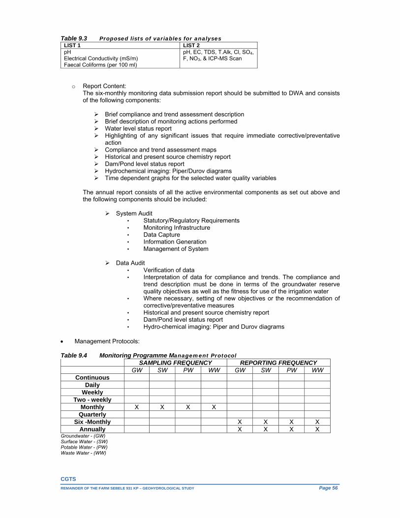
CGTS
REMAINDER OF THE FARM SEBELE 931 KP – GEOHYDROLOGICAL STUDY Page 56
Table 9.3 Proposed lists of variables for analyses LIST 1 LIST 2pH Electrical Conductivity (mS/m) Faecal Coliforms (per 100 ml)
pH, EC, TDS, T.Alk, Cl, SO4, F, NO3, & ICP-MS Scan
o Report Content: The six-monthly monitoring data submission report should be submitted to DWA and consists of the following components:
Brief compliance and trend assessment description Brief description of monitoring actions performed Water level status report Highlighting of any significant issues that require immediate corrective/preventative
action Compliance and trend assessment maps Historical and present source chemistry report Dam/Pond level status report Hydrochemical imaging: Piper/Durov diagrams Time dependent graphs for the selected water quality variables
The annual report consists of all the active environmental components as set out above and the following components should be included:
System Audit • Statutory/Regulatory Requirements • Monitoring Infrastructure • Data Capture • Information Generation • Management of System
Data Audit
• Verification of data • Interpretation of data for compliance and trends. The compliance and
trend description must be done in terms of the groundwater reserve quality objectives as well as the fitness for use of the irrigation water
• Where necessary, setting of new objectives or the recommendation of corrective/preventative measures
• Historical and present source chemistry report • Dam/Pond level status report • Hydro-chemical imaging: Piper and Durov diagrams
Management Protocols: Table 9.4 Monitoring Programme Management Protocol
SAMPLING FREQUENCY REPORTING FREQUENCY GW SW PW WW GW SW PW WW
Continuous Daily
Weekly Two - weekly
Monthly X X X X Quarterly
Six -Monthly X X X X Annually X X X X
Groundwater - (GW) Surface Water - (SW) Potable Water - (PW) Waste Water - (WW)

CGTS
REMAINDER OF THE FARM SEBELE 931 KP – GEOHYDROLOGICAL STUDY Page 57
Table 9.4 summarises the management for the monitoring programme. This enables the Quality Control Manager to control the monitoring interval and to ensure that representative data is gathered in the field during sampling runs.
The existing monitoring system and proposed upgrade which is supported by a well-informed set of resource quality objectives should serve as sufficiently early implementation of corrective/preventative measures or where necessary, the setting of new objectives.
Unsuccessful
Respectfully submitted
__________________ J. Louis. Van der Walt (Pr. Sci. Nat.) for CGTS

CGTS
REMAINDER OF THE FARM SEBELE 931 KP – GEOHYDROLOGICAL STUDY Page 58
References Chief Directorate: Surveys and Mapping; The 1:50 000 Series Topographical Maps 2426CA, CB, CC, CD, DA & DC.
Council for Geoscience, 1978; 1:250 000 Geological Maps, 2426 Thabazimbi.
DWAF, 1995; Groundwater Resources of the Republic of South Africa, SHEET 1 & SHEET 2.
DWAF, 2003; 1: 500 000 Hydrogeological map series of the Republic of South Africa, Sheet 2326 Polokwane.
DWAF, 1996; Groundwater Harvest Potential of the Republic of South Africa.
DWAF, 2002; Republic of South Africa Water Management Areas - Water Availability and Requirements.
DWAF, 2003; Municipal Demarcations of the Republic of South Africa, Task No. Gm653_03.
Midgley DC, Pitman WV, Middleton BJ, 1994; Surface Water Resources of South Africa 1990, Book of Maps, Volume II, WRC Report No 298/2.2/94.
Parsons Roger, 1995; A South African Aquifer System Management Classification, WRC Report No KV 77/95
Schulze RE, 1997; South African Atlas of Agrohydrology and Climatology, ACRU Report No 46.
Standards South Africa’s, (a division of SABS) specification for Drinking Water, SANS 241-1:2015 Edition 2.
Department of Water Affairs and Forestry, 1996. South African Water Quality Guidelines (second edition). Volume 1: Domestic.
E. Van Wyk, August 2010. Estimation of Episodic Groundwater Recharge in Semi-Arid Fractured Hard Rock Aquifers.
DWA, March 2012. “Classification of significant water resources in the Crocodile West and Marico Water Management Area (WMA 3): WP 10506.
Bredenkamp, D.B., Botha, L.J., Van Tonder, G.J. and Van Rensburg, H.J., 1995. Manual on Quantitative Estimation of Groundwater Recharge and Aquifer Storativity based on Practical Hydro- Logical Methods. Water Research Commission. Pretoria.
P.J. Hobbs Khulani Joint Venture, August 2004. Intermediate Groundwater Reserve Determination For Quaternary Catchments A21A & A21B. Project No. 2002-316.
DEPARTMENT: WATER AFFAIRS AND FORESTRY, 2006. Groundwater Resource Assessment Phase II. Task 2: GW Planning Potential.
Woodford et. al, June 2005. How Much Groundwater Does South Africa Have. Biennial Groundwater Conference, Pretoria.
Goba Moahloli Keeve Steyn (Pty) Ltd, Tlou & Matji (Pty) Ltd and Golder Associates (Pty) Ltd, 2004. Internal Strategic Perspective: Crocodile (West) and Marico Water Management Area (WMA). DWA Report No. P WMA 03/000/00/0303, February 2004.
Directorate Water Resource Classification. Department of Water Affairs, South Africa, March 2012. Classification of Significant Water Resources in the Mokolo and Matlabas Catchments: Limpopo Water Management Area (WMA) and Crocodile (West) AND Marico WMA WP 10506: Information Analysis Report: Crocodile West and Marico WMA. Report No: RDM/WMA1,3/00/CON/CLA/0112A
H. S. Swart, P.G. van Rooyen, B. Mwaka, C. Ntuli. Operating Rules for Dams with High Evaporation Losses. (DWAF, 2007).
Derek Peacock Associates, 2015. Memorandum in Support of Tourist Accommodation on the Remainder of the farm Sebele 931 KP. June 2015.
JOHANN van der MERWE (Pty) Ltd, 2015. Geotechnical Desk Study Investigation: Remainder of Sebele 931 KP. September 2015.
DWA, Guideline for groundwater resources within dolomitic areas in SA, Volume 2, August 2006
Civiconsult Consulting Engineers, December 2015. Ramotshere Moiloa Local Municipality (Ngaka Modiri Molema District Municipality)- Sebele Tourist Lodge ( Remainder of the farm Sebele 931- KP )- Services Report. Project No.2216. December 2015