ch 09 flora and fauna - energy resources of australia · flora and fauna species and epbc listed...
TRANSCRIPT

Chapter 9 Flora and fauna

Chapter 9: Flora and Fauna
ERA: Proposed Ranger 3 Deeps Underground Mine 9-i
CONTENTS
9.1 INTRODUCTION 9-1
9.2 STUDY APPROACH 9-2
9.2.1 Likelihood Analysis 9-2
9.2.1.1 Threatened Species 9-2
9.2.1.2 Migratory Species 9-5
9.2.2 Field Survey 9-7
9.2.2.1 Survey Methods 9-7
9.2.2.2 Survey Results 9-14
9.2.3 Significant Impact Assessment 9-21
9.2.3.1 Threatened Species 9-22
9.2.3.2 Migratory Species 9-47
9.3 RADIATION RISKS TO ENVIRONMENT 9-55
9.3.1 Problem Formulation and Conceptual Models 9-56
9.3.2 Environmental Media Concentrations 9-57
9.3.3 Concentration Ratios 9-58
9.3.4 Assessment Results 9-58
9.4 ASSESSMENT OF RISKS 9-60
9.5 MITIGATION 9-61
9.5.1 Habitat Degradation and/or Habitat Loss 9-61
9.5.2 Fauna Injury/Mortality 9-62
9.5.3 Invasive Flora and Fauna 9-62
9.6 SUMMARY 9-68
9.7 REFERENCES 9-69

Chapter 9: Flora and Fauna
ERA: Proposed Ranger 3 Deeps Underground Mine 9-ii
FIGURES
Figure 9-1: Location of flora and fauna survey areas 9-7
Figure 9-2: Location of 2013 fauna survey sites on the RPA 9-12
Figure 9-3: Vegetation habitat types units in the survey area 9-15
Figure 9-4: Vegetation habitat type examples 9-16
Figure 9-5: Riparian and terrestrial habitat condition assessment 9-17
Figure 9-6: EPBC Act and TPWC Act listed fauna species recorded within the survey area 9-20
Figure 9-7: Figure 9-7: a) Feral pig (Sus scrofa) observed in riparian area of Magela Creek; b) Feral
cat (Felis catus) recorded on remote camera 9-20
Figure 9-8: Availability of fauna habitat resources 9-21
Figure 9-9: Conceptual model for terrestrial assessment 9-57
Figure 9-10: Conceptual model for aquatic assessment 9-57
TABLES
Table 9-1: Likelihood of occurrence of EPBC and TPWC listed flora species, and EPBC threatened
ecological community in the survey area 9-3
Table 9-2: Likelihood of occurrence of EPBC and TPWC listed fauna species in the survey area 9-4
Table 9-3: Likelihood of occurrence of EPBC listed migratory fauna species 9-5
Table 9-4: Vegetation Assets, States and Transitions (VAST) vegetation condition descriptors for
terrestrial vegetation 9-8
Table 9-5: Indicators and ratings used to assess riparian condition in the survey area 9-9
Table 9-6: Fauna habitat resources assessment 9-13
Table 9-7: Ranking and broad summary of fauna habitat resources in each vegetation habitat type 9-13
Table 9-8: Mapping units represented under the broad mapping units in Figure 9-3 9-15
Table 9-9: Number of fauna species recorded by each survey method within the survey area 9-18
Table 9-10: Threatened and migratory fauna species recorded during the survey 9-19
Table 9-11: Likelihood of potential impacts on the eastern partridge pigeon 9-23
Table 9-12: Likelihood of potential impacts on the northern masked owl 9-25
Table 9-13: Likelihood of potential impacts on the red goshawk 9-27
Table 9-14: Likelihood of potential impacts on the yellow chat 9-28
Table 9-15: Likelihood of potential impacts on the bare-rumped sheath-tailed bat 9-30
Table 9-16: Likelihood of potential impacts on the brush-tailed rabbit-rat 9-31
Table 9-17: Likelihood of potential impacts on the Northern quoll 9-33
Table 9-18: Likelihood of potential impacts on the fawn antechinus 9-35
Table 9-19: Likelihood of potential impacts on the plains death adder 9-36
Table 9-20: Likelihood of potential impacts on the largetooth sawfish 9-38
Table 9-21: Likelihood of potential impacts on the dwarf sawfish 9-40
Table 9-22: Likelihood of potential impacts on the northern river shark 9-43
Table 9-23: Likelihood of potential impacts on the freshwater sawfish 9-45
Table 9-24: Likelihood of potential impacts on migratory species 9-54
Table 9-25: Dose rates and risk quotients for aquatic pathway 9-59
Table 9-26: Dose rates and risk quotients: terrestrial pathway 9-60
Table 9-27: Five grass species threat abatement plan objectives and actions 9-64
Chapter 9: Flora and Fauna
ERA: Proposed Ranger 3 Deeps Underground Mine 9-1
9 FLORA AND FAUNA
9.1 INTRODUCTION
This chapter presents information on the potential impacts of the Project in relation to flora
and fauna. The EIS guidelines for the Project require an adequate assessment of the
proposed actions and provision of “details of the vegetation community types occurring on
and adjacent to the proposal location, particularly including any species of flora and fauna
conservation significance” under Part 3 of the Environment Protection and Biodiversity
Conservation Act 1999 (EPBC Act) and/or the Territory Parks and Wildlife Conservation Act
2000 (TPWC Act).
In 2013, ERA engaged Eco Logical Australia to conduct a flora and fauna study, which
included a survey in the area adjacent to the proposed Project. The study incorporated the
following components, which are presented in this chapter and drawn from the Eco Logical
Australia report (Appendix 12):
� a literature review to determine the likelihood of occurrence of threatened flora and
fauna species and threatened ecology communities (Section 9.2.1);
� Characterisation of the potential habitat of threatened species in the study area,
including vegetation types and other identifiable features (Section 9.2.2);
� baseline surveys for reptiles, birds, and mammals (including microbats), including
targeted surveys for threatened EPBC and NT listed fauna species that occur in the
study area (Section 9.2.2); and
� Determination of the potential impacts of the Project on EPBC and NTPWC listed
species, using the EPBC Act MNES Significant Impact Guidelines 1.1 developed by the
Commonwealth of Australia (2013) (Section 9.2.3).
This chapter also assesses the potential radiation risk to the flora and fauna as a result of the
Project. Section 9.3 presents the outcomes of this assessment undertaken using the ERICA
tool.1
Eco Logical Australia also participated in the environmental risk assessment workshop
(Appendix 5) for the Project in December 2013, and contributed to the risks identified in
Section 9.4 and the mitigation measures in Section 9.5.
1 ERICA – Environmental Risk from Ionising Contaminants: Assessment and Management and recommended as an
appropriate assessment tool by the Australian Radiation Protection and Nuclear Safety Agency (ARPANSA).

Chapter 9: Flora and Fauna
ERA: Proposed Ranger 3 Deeps Underground Mine 9-2
9.2 STUDY APPROACH
9.2.1 Likelihood Analysis
An assessment was conducted of the likelihood of each EPBC and TPWC listed threatened
flora and fauna species and EPBC listed migratory species occurring within the survey area.
The purpose of the assessment was to provide a focus for the species to be targeted in the
survey (Section 9.2.2) and for the significant impact assessment (Section 9.2.3).
Information was sourced from previous surveys on the RPA, and from the following
databases.
� Commonwealth Department of the Environment (DoE) Protected Matters database,
28 August 2013;
� Flora Atlas NT, Department of Land Resource Management (DLRM), 30 October 2013;
and
� NT Fauna Atlas, DLRM, 30 October 2013.
Full details are available in Appendix 12.
9.2.1.1 Threatened Species
All plant species and ecological communities identified were assessed as highly unlikely to
occur and are not discussed further (Table 9-1).

Chapter 9: Flora and Fauna
ERA: Proposed Ranger 3 Deeps Underground Mine 9-3
Table 9-1: Likelihood of occurrence of EPBC and TPWC listed flora species, and EPBC threatened ecological community in
the survey area
Name EPBC status TPWC status Likelihood of
occurrence*
Distance** to survey
area
Arnhem Plateau Sandstone Shrubland
Complex
Threatened
ecological
community
Not listed Highly unlikely 4 km
Acacia sp. Graveside Gorge Critically
endangered
Critically
endangered
Highly unlikely Incorrect record: 5 km
Actual record: 77 km
Hibiscus brennanii Vulnerable Vulnerable Highly unlikely 9 km
Sauropus filicinus Vulnerable Data deficient Highly unlikely 9 km
Hibbertia brennanii Not listed Vulnerable Highly unlikely 9 km
Hibbertia tricornis Not listed Vulnerable Highly unlikely 9 km
Lithomyrtus linariifolia Not listed Vulnerable Highly unlikely 9 km
*Likelihood definitions:
'Known' = the species has been recorded within the survey area within the last decade.
'Likely' = a medium to high probability that a species uses the survey area. The species has been recorded within the local area and
habitat within the site is considered to be highly suitable.
'Possible' = a medium to low probability that a species used the survey area. The species has been recorded within the local area or region
and habitat within the site is considered to be moderately suitable.
'Unlikely' = a very low to low probability that a species uses the survey area. The species may or may not occur locally or regionally,
however based on the known habitat requirements of the species, and habitat available within the site, the site is considered unlikely to be
suitable or marginal at best.
'Highly unlikely'= habitat on and in the vicinity is highly unsuitable for the species. Based on the known habitat requirements of the species,
the site lacks the required habitat.
**Distance has been recorded to nearest whole kilometre
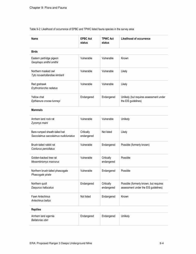
Four bird and four mammal species were assessed as 'known' or 'likely' within the survey
area (Table 9-2). An assessment of the potential impact on these species from the Project is
discussed in Section 9.5. Species that were identified as requiring assessment in the EIS
guidelines are also included, such as the plains death adder and yellow chat (Alligator
Rivers).
Chapter 9: Flora and Fauna
ERA: Proposed Ranger 3 Deeps Underground Mine 9-4
Table 9-2: Likelihood of occurrence of EPBC and TPWC listed fauna species in the survey area
Name EPBC Act
status
TPWC Act
status
Likelihood of occurrence
Birds
Eastern partridge pigeon
Geophaps smithii smithii
Vulnerable Vulnerable Known
Northern masked owl
Tyto novaehollandiae kimberli
Vulnerable Vulnerable Likely
Red goshawk
Erythrotriorchis radiatus
Vulnerable Vulnerable Likely
Yellow chat
Epthianura crocea tunneyi
Endangered Endangered Unlikely (but requires assessment under
the EIS guidelines)
Mammals
Arnhem land rock rat
Zyzomys maini
Vulnerable Vulnerable Unlikely
Bare-rumped sheath-tailed bat
Saccolaimus saccolaimus nudicluniatus
Critically
endangered
Not listed Likely
Brush-tailed rabbit rat
Conilurus penicillatus
Vulnerable Endangered Possible (formerly known)
Golden-backed tree rat
Mesembriomys macrurus
Vulnerable Critically
endangered
Possible
Northern brush-tailed phascogale
Phascogale pirate
Vulnerable Endangered Possible
Northern quoll
Dasyurus hallucatus
Endangered Critically
endangered
Possible (formerly known, but requires
assessment under the EIS guidelines)
Fawn Antechinus
Antechinus bellus
Not listed Endangered Known
Reptiles
Arnhem land egernia
Bellatorias obiri
Endangered Endangered Unlikely
Chapter 9: Flora and Fauna
ERA: Proposed Ranger 3 Deeps Underground Mine 9-5
Name EPBC Act
status
TPWC Act
status
Likelihood of occurrence
Plains death adder
Acanthophis hawkei
Vulnerable Vulnerable Highly unlikely (but requires assessment
under the EIS guidelines)
Fish
Largetooth sawfish
Pristis pristis
Vulnerable Vulnerable Highly unlikely (but requires assessment
under the EIS guidelines)
Dwarf sawfish
Pristis clavata
Vulnerable Vulnerable Highly unlikely (but requires assessment
under the EIS guidelines)
Northern river shark
Glyphis garricki
Endangered Endangered Highly unlikely (but requires assessment
under the EIS guidelines)
Speartooth shark
Glyphis glyhis
Critically
endangered
Vulnerable Highly unlikely (but requires assessment
under the EIS guidelines)
9.2.1.2 Migratory Species
Seven migratory bird species that breed within Australia, six migratory bird species that do
not breed in Australia, and one reptile were assessed as 'known' or 'likely' within the survey
area (Table 9-3). The regional distribution and ecology of each species is discussed below
with an assessment of the likelihood of potential impact.
Table 9-3: Likelihood of occurrence of EPBC listed migratory fauna species
Name EPBC Act
status
TPWC Act
status
Likelihood of occurrence
Migratory birds
Barn swallow
Hirundo rustica
Migratory Not listed Possible
Cattle egret
Ardea ibis
Migratory Not listed Known
Common sandpiper
Actitis hypoleucos
Migratory Not listed Known (but not recorded in 2013 survey)
Derby white-browed robin
Poecilodryas superciliosa cerviniventris
Migratory Not listed Likely
Eastern great egret
Ardea modesta
Migratory Not listed Known

Chapter 9: Flora and Fauna
ERA: Proposed Ranger 3 Deeps Underground Mine 9-6
Name EPBC Act
status
TPWC Act
status
Likelihood of occurrence
Migratory birds
Gouldian finch
Erythrura gouldiae
Endangered,
migratory
Vulnerable Possible
Grey plover
Pluvialis squatarola
Migratory Not listed Possible (but requires assessment under
the EIS guidelines)
Marsh sandpiper
Tringa stagnatilis
Migratory Not listed Known (but not recorded in 2013 survey)
Melville cicadabird
Coracina tenuirostris melvillensis
Migratory Not listed Likely
Oriental plover
Charadrius veredus
Migratory Not listed Likely
Oriental pratincole
Glareola maldivarum
Migratory Not listed Likely
Rainbow bee-eater
Merops ornatus
Migratory Not listed Known
Rufous fantail
Rhipidura rufifrons
Migratory Not listed Likely
Terek sandpiper
Xenus cinereus
Migratory Not listed Likely
Whimbrel
Numenius phaeopus
Migratory Not listed Known (but not recorded in 2013 survey)
White-bellied sea-eagle
Haliaeetus leucogaster
Migratory Not listed Known
Migratory reptiles
Saltwater crocodile
Crocodylus porosus
Migratory Not listed Known

Chapter 9: Flora and Fauna
ERA: Proposed Ranger 3 Deeps Underground Mine 9-7
9.2.2 Field Survey
Flora and fauna surveys were conducted over approximately 220 ha to encompass an area
of potential interaction with the Project (Figure 9-1). The area was selected to include
Magela Creek and the associated riverine vegetation corridor, Georgetown Billabong, and
the transition between riverine and woodland vegetation. Targeted wetland surveys were
also conducted at Retention Pond 1 (RP1) outside the primary survey area, due to the
possibility that it could host migratory species that use the area contained within the
maximum extent of infrastructure for the Project.
Figure 9-1: Location of flora and fauna survey areas
9.2.2.1 Survey Methods
Flora
Vegetation mapping was undertaken in three stages:
1. An interim vegetation map was developed prior to the field survey, based on a World
View 2 satellite image (captured in June 2013). Vegetation community boundaries were
delineated from polygons and classified to level 3 of the National Vegetation Information
System (NVIS) .2 A vegetation community is defined under the NVIS as 'an assemblage
of plant species which are structurally and floristically similar and form a repeating unit
across the landscape' (Brocklehurst, et al. 2007: p. 3).
2 The NVIS is a systematic way to describe vegetation communities at six levels depending on the floristic and structural
information available. Level 6 provides the greatest level of detail.

Chapter 9: Flora and Fauna
ERA: Proposed Ranger 3 Deeps Underground Mine 9-8
2. Detailed site data were collected during broad and detailed field surveys conducted in
September 2013 to validate the interim vegetation map. The surveys followed the 'NT
Guidelines and Field Methodology for Vegetation Survey Mapping' (Brocklehurst, et al.
2007), which are compatible with the NVIS (Department of the Environment 2013) and
'Australian Vegetation Survey Guidelines' (Hnatiuk, et al. 2009). Vegetation units were
mapped to NVIS level 5 from the broad vegetation survey and up to NVIS level 6 from the
detailed surveys.
3. A final vegetation map was produced, which consisted of vegetation mapping units which
were based on the interim map, and amalgamated from the broad and detailed field
survey data. The units were mostly at NVIS level 3 (e.g., Eucalyptus open woodland),
with some at NVIS level 4 (e.g., Eucalyptus tetrodonta open woodland).
4. Vegetation mapping units were further amalgamated into vegetation habitat types to
reflect the provision of similar fauna habitat resources. For example all grassland
mapping groups were amalgamated into the vegetation habitat type 'grassland' since
they provide seed resources.
Vegetation condition assessment
Vegetation condition was assessed to take into account past and present land use,
disturbances and land management, hence providing an overview of the cumulative effects
of these impacts on vegetation communities. The assessment was guided by a desktop
review of the survey area's disturbance history, examination of the field survey data and
consultation with ERA staff. Separate condition assessments were completed for terrestrial
and riparian vegetation communities. The Vegetation Assets, States and Transitions (VAST)
framework developed by Thackway and Lesslie (2006) was used to assess the condition of
terrestrial vegetation in the survey area (Table 9-4).
Riparian vegetation condition was assessed according to the 'Tropical Rapid Appraisal of
Riparian Condition (TRARC), described in Dixon, et al. (2006). An index of condition was
derived from indicators and scored, with final ratings of poor to excellent (Table 9-5). An
index of pressure was also derived from six indicators (bank stability, animals, fire, tree
clearing, flow regime, anthropogenic alterations) which helped to identify the likely causes of
change in condition.
Table 9-4: Vegetation Assets, States and Transitions (VAST) vegetation condition descriptors for terrestrial vegetation
Type Vegetation condition
Residual bare Areas where native vegetation does not naturally exist
Residual Native vegetation community structure, composition and regenerative capacity intact – no
significant perturbation from land use/land management practice
Modified Native vegetation community structure, composition and regenerative capacity perturbed
Transformed Native vegetation community structure, composition and regenerative capacity significantly
altered by land use/land management practice
Replaced - adventive Native vegetation replacement – species alien to locality and spontaneous in occurrence
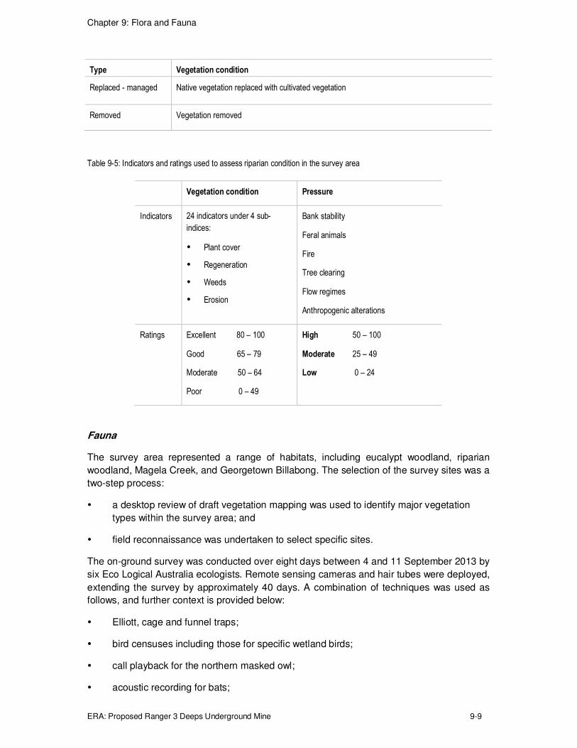
Chapter 9: Flora and Fauna
ERA: Proposed Ranger 3 Deeps Underground Mine 9-9
Type Vegetation condition
Replaced - managed Native vegetation replaced with cultivated vegetation
Removed Vegetation removed
Table 9-5: Indicators and ratings used to assess riparian condition in the survey area
Vegetation condition Pressure
Indicators 24 indicators under 4 sub-
indices:
� Plant cover
� Regeneration
� Weeds
� Erosion
Bank stability
Feral animals
Fire
Tree clearing
Flow regimes
Anthropogenic alterations
Ratings Excellent 80 – 100
Good 65 – 79
Moderate 50 – 64
Poor 0 – 49
High 50 – 100
Moderate 25 – 49
Low 0 – 24
Fauna
The survey area represented a range of habitats, including eucalypt woodland, riparian
woodland, Magela Creek, and Georgetown Billabong. The selection of the survey sites was a
two-step process:
� a desktop review of draft vegetation mapping was used to identify major vegetation
types within the survey area; and
� field reconnaissance was undertaken to select specific sites.
The on-ground survey was conducted over eight days between 4 and 11 September 2013 by
six Eco Logical Australia ecologists. Remote sensing cameras and hair tubes were deployed,
extending the survey by approximately 40 days. A combination of techniques was used as
follows, and further context is provided below:
� Elliott, cage and funnel traps;
� bird censuses including those for specific wetland birds;
� call playback for the northern masked owl;
� acoustic recording for bats;

Chapter 9: Flora and Fauna
ERA: Proposed Ranger 3 Deeps Underground Mine 9-10
� nocturnal and diurnal active searches;
� remote cameras;
� hair tubes; and
� flushing and area surveys.
The survey targeted fauna species that had been identified in the likelihood assessment in
Section 9.2.1 (refer Table 9-1). These species were assessed as likely or possible to occur
in the study area or had been recorded on the RPA in previous surveys (known). Two
species were assessed as being unlikely (yellow chat and Northern death adder); however,
they were targeted as the EIS guidelines require their assessment. The type of survey
methods were determined by the identified species. For example tree-mounted traps were
used specifically to target the golden-backed tree rat.
The techniques incorporate the Commonwealth Department of the Environment guidelines
for the survey of Australia's threatened fauna (DEWHA 2010; 2011; SEWPaC 2011) and
EPBC Act requirements, and are briefly described in the following sections. Additional detail
is provided in Appendix 12.
Trapping was undertaken at six sites (Figure 9-2), where a transect was established
comprising of:
� 20 small Elliott traps3 spaced at approximately 10 m intervals;
� 5 large Elliott traps mounted 1.5 m – 1.8 m above the ground on suitable large trees;
� 4 treadle activated wire cage traps (500 mm x 250 mm x 250 mm); and
� 10 funnel traps distributed in pairs along a 30 m drift fence.
Dawn and dusk wetland bird censuses were conducted at Georgetown Billabong between 8
and 11 September, and a dawn census was conducted at RP1 on 10 September. Each
census was between 25 minutes and 2 hours in duration. All birds observed or identified from
calls within the wetland and the fringing riverine forest were recorded.
All birds observed or heard while working around the survey area were recorded, which
included the time during installation of trap lines and cameras and nocturnal surveys. In
addition, between 6 and 10 September bird surveys were conducted at each transect while
checking traps at dawn.
Call playback for the northern masked owl (Tyto novaehollandiae kimberli) was conducted in
conjunction with one nocturnal active search per night, for five nights. Masked owl calls were
played through car speakers for two minutes, followed by five minutes of observation for a
response (either through call or sighting); this procedure was repeated three times.
A Wildlife Acoustics SM2BAT+ bat detector4 was deployed at three sites for two nights each.
The recorded data was provided to Specialised Zoological (Adelaide)5 who identified the bat
species.
3 An Elliott trap is a rectangular shaped structure constructed from aluminium, and designed to trap rodents and small
marsupials. A trap is usually baited and set in the evening, and checked at dawn.

Chapter 9: Flora and Fauna
ERA: Proposed Ranger 3 Deeps Underground Mine 9-11
Nine nocturnal searches were conducted between 5 and 10 September 2013. One search
was conducted at Georgetown Billabong and two at the trapping transects. The remaining six
searches were independent of other survey sites. During each search, one to four people
searched with high-powered head or handheld torches. Searches lasted between half an
hour and two hours. Two diurnal searches were conducted by three people for one hour.
These searches included recording birds observed and heard, raking through leaf litter,
peeling back loose bark and lifting logs and rocks.
A total of 30 motion-activated cameras were deployed in the survey area for approximately
40 nights. Five cameras were placed 50 m apart in six transects. Three habitat types were
represented (woodland, riparian areas, and within Magela Land Application Area (Magela
LAA) disturbed area) with two transects for each habitat. Cameras were mounted on large
trees approximately 60 cm above the ground and each camera was aimed at a baited hair
tube.
A total of 60 hair tubes (90 mm diameter) were deployed in conjunction with the motion-
activated cameras, in order to attract fauna. Two hair tubes were placed with each camera
(50 m apart). The hair tubes were baited with universal bait, and any hair samples on the
adhesive tape within the rim of the trap were identified post survey by an external party
(Dead Fish, Genoa, Victoria).
Flushing surveys6 and searches for habitat, signs of activity and predator scats were
undertaken by the flora and fauna teams while traversing and working on the site. Signs of
animal activity including tracks and diggings that could be associated with particular species
were also recorded. Any fauna observed while travelling between survey sites were recorded
as incidental observations or opportunistic sightings.
4 A device that records high frequency sounds.
5 http://gaiaresources.com.au/products_anabat.php
6 A survey method in which a group of observers walk parallel at a short spacing between each other, across an area of
suitable habitat in an attempt to flush any birds that may be present.

Chapter 9: Flora and Fauna
ERA: Proposed Ranger 3 Deeps Underground Mine 9-12
Figure 9-2: Location of 2013 fauna survey sites on the RPA
Fauna habitat resource mapping
The EPBC survey guidelines for mammals, birds and reptiles state that a detailed map of the
study area should be developed to reveal the type, locations and condition of important fauna
habitat features (DEWHA 2010; 2011; SEWPaC 2011). To address these guidelines, and to
establish a broader context for evaluating potential impacts of the project on fauna species,
habitat values of the survey area were assessed by integrating information generated from
the vegetation mapping, vegetation condition assessment and fauna likelihood analysis.
Vegetation habitat type (from vegetation mapping) and vegetation condition information were
used to evaluate the location and condition of relevant habitat resources within the survey
area. The method of assessment for each fauna habitat resource is shown in Table 9-6, and
a summary of how the resources were ranked for each vegetation habitat type is shown in
Table 9-7.

Chapter 9: Flora and Fauna
ERA: Proposed Ranger 3 Deeps Underground Mine 9-13
Table 9-6: Fauna habitat resources assessment
Fauna habitat resource Method of assessment
Wetlands and other water sources Distance to water was assessed (e.g., creeks, billabongs, sumps)
Nectar or fleshy fruit bearing flowering
tree species
Quality of resource based on the density, variety, and condition of
flowering and fruiting trees.
Rated 'poor', 'good' or 'excellent'
Tree hollows and hollow logs Hollows cannot always be identified or evaluated via ground-based
inspection, so the quality of available hollows was estimated based on
vegetation height, diversity and fire history.
Rated 'poor', 'good' or 'excellent'
Seed bearing grasses The quality of this resource within each polygon was determined based
on the range and density of grass species.
Rated 'poor', 'good', 'excellent'
Table 9-7: Ranking and broad summary of fauna habitat resources in each vegetation habitat type
Vegetation habitat
type
Availability of nectar, fruit and
seeds
Availability of hollows Availability of grass
seeds
Acacia shrubland Poor – Acacia leaf glands secrete
nectar which is a food source
primarily for invertebrates.
Honeyeaters have also been
observed feeding on Acacia
nectar. Parrots may eat seeds.
Poor – Acacias generally do
not form hollows suitable for
vertebrate fauna
Poor to good – depending
on fire history and
openness, Acacia can have
a grass seed bearing
understorey
Corymbia and
Eucalyptus woodland
Poor to excellent – Corymbia and
Eucalyptus flowers can provide a
good source of nectar used by
mammals, birds and occasionally
geckos. Gumnuts provide a food
source for parrots.
Good to excellent –
depending on fire history,
mature Eucalyptus and
Corymbia woodland can
provide suitable hollows in
live trees and fallen wood
Poor to excellent – the
quality of grassy understory
within woodland is
determined by the fire
history and consequently
openness of the vegetation
community
Georgetown
Billabong surrounds
Poor – the Georgetown Billabong
area is populated by perennial
species
Poor – the Georgetown
Billabong are is populated
by perennial species
Excellent – the Georgetown
Billabong area supports
grasses that seed
throughout the year

Chapter 9: Flora and Fauna
ERA: Proposed Ranger 3 Deeps Underground Mine 9-14
Vegetation habitat
type
Availability of nectar, fruit and
seeds
Availability of hollows Availability of grass
seeds
Grasslands Poor – few species within
grasslands produce nectar or fruit
Poor – grasslands may
support low densities of
hollow bearing trees or
fallen logs,
Good to excellent –
depending on fire history
Riparian Good to Excellent- Melaleuca
flowers produce nectar that is
eaten by birds and mammals,
including bats. Many riparian
trees including Eucalyptus
product fruit.
Good - Hollows occur in
riparian Eucalyptus
Good to excellent –
Riparian areas support
large patches of grasslands
and woodlands with grass
understorey
Cleared Poor Poor Poor
9.2.2.2 Survey Results
Flora
Thirty-three vegetation mapping units were identified and mapped in the survey area. A
detailed description of the vegetation mapping units is given in Appendix 12. The vegetation
habit types derived from the mapping units are shown in Figure 9-3 and Table 9-8.
Photographic examples of these vegetation habitat types are shown in Figure 9-4.
� The shrubland group was characterised by variable stages of vegetation regrowth
following disturbance (mainly from clearing), and was dominated by Acacia sp. (e.g.
Acacia holesericia), with some regrowth of Eucalyptus sp. as shrubs.
� The grassland group was dominated by species such as Eriachne triseta, Heteropogon
triticeus, and Sorghum sp., and some small areas of turkey bush (Calytrix exstipulata)
shrubland.
� The woodland group consisted mostly of Corymbia sp. and Eucalyptus sp. in particular
Darwin stringybark (E. tetrodonta) and Darwin woolybutt (E. miniata).
� The riparian group consisted of Melaleuca sp. in various structural classes – from open
forest to open woodland. There were areas of grassland dominated by Pseudoraphis
spinescens in the creek bed, and Poacea sp. in the transition zone between riparian
and terrestrial vegetation zones.
� The billabong and billabong fringe classes incorporate inundated and dry areas of
Georgetown Billabong respectively. The billabong vegetation consisted of waterlillies
(Nymphaea violacea) in deeper water areas, and sedges (Eleocharis dulcis) in the
shallow water. The billabong fringe consisted of cracked soils, fringed by closed
grassland of Leersia hexandra, and senescent sedgeland comprised of Eleocharis
dulcis.
No threatened flora species or communities were found during the survey, which was
consistent with previous flora surveys on the RPA.

Chapter 9: Flora and Fauna
ERA: Proposed Ranger 3 Deeps Underground Mine 9-15
Table 9-8: Mapping units represented under the broad mapping units in Figure 9-3
Broad mapping unit Mapping unit
Shrubland Acacia auriculiformis shrubland, Acacia holosericea, open shrubland, Acacia holosericea
shrubland, Acacia holosericea sparse shrubland, Acacia open shrubland, Acacia shrubland,
dead Acacia open shrubland, and Calytrix open shrubland.
Grassland Closed grassland, Eriachne triseta grassland Eriachne triseta open grassland, grassland,
Heteropogon triticeus open grassland, Heteropogon triticeus sparse grassland,
Pseudoraphis spinescens closed grassland, Sorghum grassland, and Sorghum open
grassland.
Woodland Corymbia open woodland, Corymbia polycarpa open woodland, Eucalyptus open woodland,
Eucalyptus shrubland, Eucalyptus tetrodonta open woodland, Eucalyptus tetrodonta
woodland, Eucalyptus woodland and Xanthostemon paradoxus open shrubland.
Riparian Melaleuca argentea open woodland/woodland, Melaleuca viridiflora open forest, Melaleuca
viridiflora open woodland, Melaleuca viridiflora shrubland, Melaleuca viridiflora woodland,
and mixed riparian.
Cleared Cleared
Billabong Billabong
Billabong fringe Billabong fringe
Figure 9-3: Vegetation habitat types units in the survey area

Chapter 9: Flora and Fauna
ERA: Proposed Ranger 3 Deeps Underground Mine 9-16
Figure 9-4: Vegetation habitat type examples
Vegetation condition assessment
The outcome of the condition assessment of terrestrial and riparian vegetation communities
in the survey area is presented in Figure 9-5. The survey area has been subject to
significant disturbance ranging from mining related activities such as irrigation by pond water
(or land application) and clearing, to naturally occurring events such as fire, flooding and
storms/cyclones, and impacts due to feral pigs and weeds.

Chapter 9: Flora and Fauna
ERA: Proposed Ranger 3 Deeps Underground Mine 9-17
Terrestrial vegetation communities accounted for 50% of the survey area. The condition of
these communities varied from residual to transformed; most vegetation not affected by
irrigation was rated as residual, with fire being the only disturbance. Vegetation condition
within the Magela LAA varied between modified and transformed. Clearing associated with
exploration and other mine-related activities was evident in terrestrial areas. Cleared areas
occurred predominantly in the central sections of the survey area and consisted primarily of a
network of tracks and drill pads for exploration, and a borrow pit (approximately 2 ha). This
clearing has impacted the availability of habitat resources across the broader survey area
and results in small-scale habitat fragmentation.
Minor occurrences of the introduced annual mission grass (Cenchrus pedicellatum) were
recorded during the survey in the Magela LAA. Four of the five patches were equal to or less
than 1 m in diameter while one patch was 50 m in diameter. Minor occurrences of
passionfruit (Passiflora foetida) were also recorded in the area, but the exotic species is
regarded as a naturalised vine in the NT (Smith 2002). It should be noted that weed
management had recently been undertaken in the area and results from a single survey in
September 2013 should not be taken as a comprehensive assessment of all weeds that may
be present in the survey area under different seasonal conditions.
Riparian vegetation communities represent the remaining 50% of the survey area. The
condition of these communities varied between good and excellent, with most riparian areas
rated as excellent. Those areas rated as good were downgraded from excellent based on
damage from feral pigs. No clearing was evident in the riparian vegetation communities.
Figure 9-5: Riparian and terrestrial habitat condition assessment
Chapter 9: Flora and Fauna
ERA: Proposed Ranger 3 Deeps Underground Mine 9-18
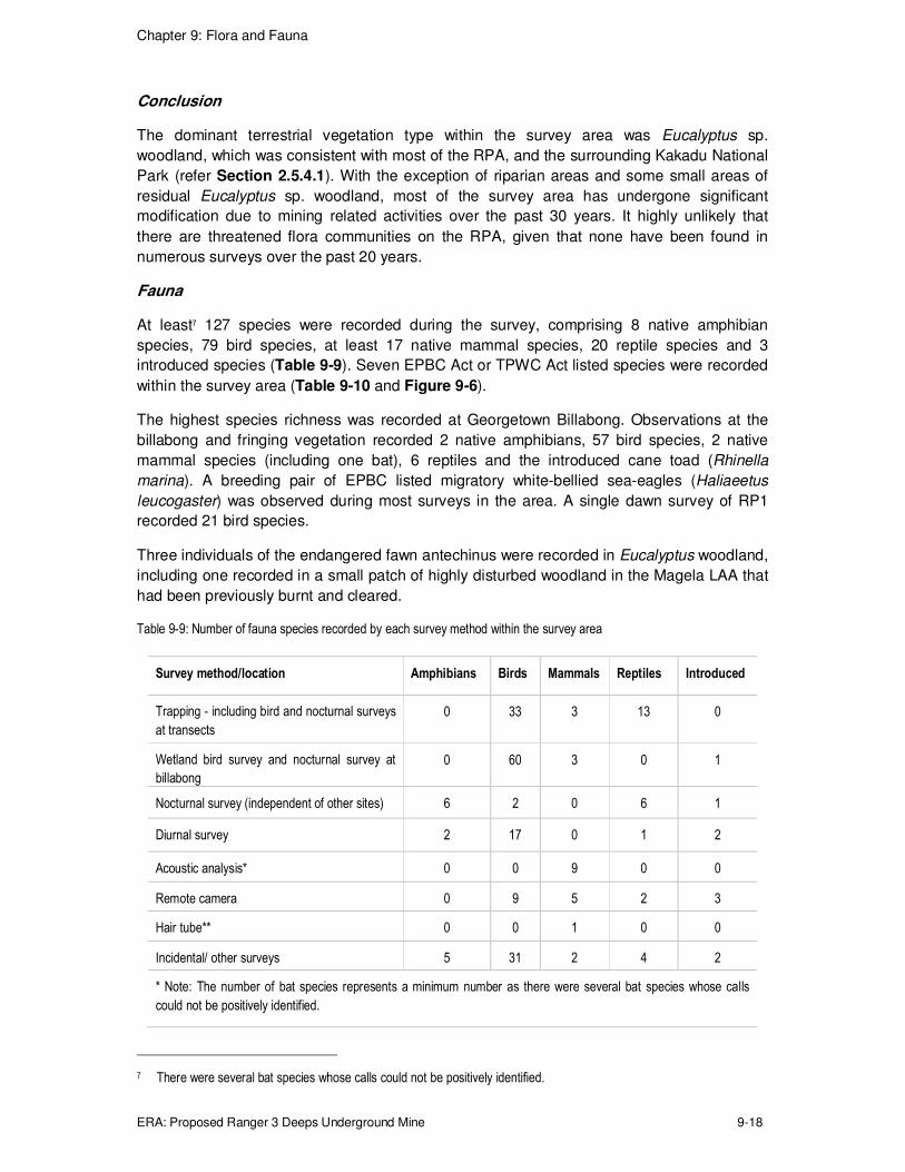
Conclusion
The dominant terrestrial vegetation type within the survey area was Eucalyptus sp.
woodland, which was consistent with most of the RPA, and the surrounding Kakadu National
Park (refer Section 2.5.4.1). With the exception of riparian areas and some small areas of
residual Eucalyptus sp. woodland, most of the survey area has undergone significant
modification due to mining related activities over the past 30 years. It highly unlikely that
there are threatened flora communities on the RPA, given that none have been found in
numerous surveys over the past 20 years.
Fauna
At least7 127 species were recorded during the survey, comprising 8 native amphibian
species, 79 bird species, at least 17 native mammal species, 20 reptile species and 3
introduced species (Table 9-9). Seven EPBC Act or TPWC Act listed species were recorded
within the survey area (Table 9-10 and Figure 9-6).
The highest species richness was recorded at Georgetown Billabong. Observations at the
billabong and fringing vegetation recorded 2 native amphibians, 57 bird species, 2 native
mammal species (including one bat), 6 reptiles and the introduced cane toad (Rhinella
marina). A breeding pair of EPBC listed migratory white-bellied sea-eagles (Haliaeetus
leucogaster) was observed during most surveys in the area. A single dawn survey of RP1
recorded 21 bird species.
Three individuals of the endangered fawn antechinus were recorded in Eucalyptus woodland,
including one recorded in a small patch of highly disturbed woodland in the Magela LAA that
had been previously burnt and cleared.
Table 9-9: Number of fauna species recorded by each survey method within the survey area
Survey method/location Amphibians Birds Mammals Reptiles Introduced
Trapping - including bird and nocturnal surveys
at transects
0 33 3 13 0
Wetland bird survey and nocturnal survey at
billabong
0 60 3 0 1
Nocturnal survey (independent of other sites) 6 2 0 6 1
Diurnal survey 2 17 0 1 2
Acoustic analysis* 0 0 9 0 0
Remote camera 0 9 5 2 3
Hair tube** 0 0 1 0 0
Incidental/ other surveys 5 31 2 4 2
* Note: The number of bat species represents a minimum number as there were several bat species whose calls
could not be positively identified.
7 There were several bat species whose calls could not be positively identified.

Chapter 9: Flora and Fauna
ERA: Proposed Ranger 3 Deeps Underground Mine 9-19
** Note: Unseasonal rain impacted on the hair tubes, reducing the stickiness of the tape within the first week of the
survey period. Two mammal hair samples (each comprising a single hair) were sent for analysis, one was identified
as a dingo hair, and the other was a contaminant human hair
Table 9-10: Threatened and migratory fauna species recorded during the survey
Common name EPBC Act
(C'wealth)
status
TPWC Act
(NT) status
Survey method Observation notes
Partridge pigeon
(Geophaps smithii
smithii)
Vulnerable Vulnerable Incidental
observation
Two flocks of Eastern Partridge
Pigeons were observed on 7 and 10
September in Eliocharis sedgeland in
the southern dry section of
Georgetown Billabong.
Cattle egret (Ardea
ibis)
Migratory None Wetland bird survey
(Georgetown
Billabong)
A Cattle Egret was observed at
Georgetown Billabong, 11
September.
Eastern great egret
(Ardea modesta)
Migratory None Wetland bird survey
(Georgetown
Billabong and RP1)
The Eastern Great Egrets were
observed at Georgetown Billabong 7,
8, 9 and 11 September, and RP1 on
10 September.
Rainbow bee-eater
(Merops ornatus)
Migratory None Bird census, remote
camera, wetland
bird survey
(Georgetown
Billabong, RP1,
Magela Creek)
incidental
observation
Rainbow Bee-eaters were observed
at Georgetown Billabong, transects A,
B, C, E, and F, and in the Magela
Creek bed thought the survey period.
Two burrows were observed.
White-bellied sea-
eagle (Haliaeetus
leucogaster)
Migratory None Wetland bird survey
(Georgetown
Billabong), incidental
observation
A breeding pair of White-bellied Sea-
eagles were observed at Georgetown
Billabong throughout the survey
period.
Saltwater crocodile
(Crocodylus porosus)
Migratory None Nocturnal survey A saltwater Crocodile was observed
at Georgetown Billabong on 7 and 10
September
Fawn antechinus
(Antechinus bellus)
None Endangered Trapping, remote
camera
One female Fawn Antechinus was
trapped adjacent to the proposed vent
corridor at transect A. A further two
were captured on camera at
woodland transects H and J.

Chapter 9: Flora and Fauna
ERA: Proposed Ranger 3 Deeps Underground Mine 9-20
Figure 9-6: EPBC Act and TPWC Act listed fauna species recorded within the survey area
Three species of introduced fauna were recorded during the survey:
� pigs (Sus scrofa) and associated damage were observed in the riparian area of Magela
Creek and at Georgetown Billabong sites (Figure 9-7a);
� a cat (Felis catus) was recorded on a remote camera transect (Figure 9-7b);
� the cane toad (Rhinella marina) was observed at Georgetown Billabong and at some of
the camera and trapping transects.
There was evidence of buffalo grazing in riparian grassland in the south west of the survey
area, but no significant disturbance was evident.
Figure 9-7: Figure 9-7: a) Feral pig (Sus scrofa) observed in riparian area of Magela Creek; b) Feral cat (Felis catus)
recorded on remote camera

Chapter 9: Flora and Fauna
ERA: Proposed Ranger 3 Deeps Underground Mine 9-21
Fauna habitat resource mapping
Three of the four fauna habitat resources (values) were mapped within the survey area
(Figure 9-8):
� nectar, fruit and seeds;
� hollows; and
� grass seeds.
Access to water is excellent across the entire site, due to the proximity of Magela Creek
which incorporates both Georgetown Billabong, and a series of permanent pools. Outside of
the survey area, water is also available from other creeks, and numerous sumps and
constructed wetlands, such as RP1.
Approximately half of the survey area contains riparian vegetation communities, with the
majority in excellent condition and providing excellent fauna habitat values in terms of
availability of nectar/ fruit/ seed; hollows; and grass seeds. Nectar, fruit and seed availability
was highest within the riparian vegetation adjoining Magela Creek.
Figure 9-8: Availability of fauna habitat resources
9.2.3 Significant Impact Assessment
An assessment of the Project on threatened and migratory fauna species against the EPBC
Act significant impact criteria is presented below. The assessment is based on those species
identified in the likelihood assessment (Section 9.2.1) and the flora and fauna survey
(Section 9.2.2).
Each significant impact criterion for a species was assessed as 'likely' or 'unlikely', where to
be likely, the criterion was considered to have a greater than 50% chance of occurring
(DEWHA 2013)

Chapter 9: Flora and Fauna
ERA: Proposed Ranger 3 Deeps Underground Mine 9-22
9.2.3.1 Threatened Species
The following section addresses four bird species, four mammals, four fish and one reptile
species that are known or considered likely to occur on the RPA, or require assessment
under the EIS guidelines
Eastern partridge pigeon (Geophaps smithii smithii)
Regional distribution and ecology
The eastern partridge pigeon is restricted to sub-coastal areas of the Top End of NT where
most recent records are from Kakadu National Park and between Katherine and Darwin. The
eastern partridge pigeon prefers open forest and woodland dominated by Darwin stringybark
(Eucalyptus tetrodonta) and Darwin woolybutt (E. miniata), with a structurally diverse
understorey.
The eastern partridge pigeon is relatively sedentary and, if there is permanent water nearby,
will commonly occupy the same area throughout the year. The pigeon nest on the ground,
usually in a shallow depression lined with grass or leaves and has been known to lay eggs in
all months of the year, although the bulk of nesting occurs in the early to mid-dry season.
The bird is known to forage on a wide variety of seeds from grasses, legumes, herbs and
also shrubs and trees.
Threats to the pigeon include land use activities, such as vegetation clearing and fire, that
result in detrimental floristic and structural changes to the habitat occupied by the bird.
Potential habitat on RPA, survey findings
Critical habitat for the eastern partridge pigeon comprises intricately burnt mosaics within
open forests with grassy understorey, where the species nests in patches of unburnt
Sorghum in that mosaic. This habitat occurs within the survey area and most of the RPA.
Two flocks (of 8 to 12, and 4 individuals) were observed in Eliocharis sedgeland in the dry
southern section of Georgetown Billabong during the September 2013 survey.
Assessment of potential impact
The likelihood of impact on the eastern partridge pigeon by the Project for each significant
impact criterion is described in Table 9-11. It is considered unlikely that there will be
significant impacts on partridge pigeons from clearing of native vegetation associated with
the proposed development.

Chapter 9: Flora and Fauna
ERA: Proposed Ranger 3 Deeps Underground Mine 9-23
Table 9-11: Likelihood of potential impacts on the eastern partridge pigeon
Significant impact criteria Likelihood Assessment
Leads to a long-term decrease in the size of an
important population of eastern partridge
pigeons
Unlikely It is unlikely that clearing associated with the Project will
have any impact on the local population of eastern
partridge pigeons as the species remains common in the
undisturbed parts of the RPA, and a significant population
occurs in neighbouring Kakadu National Park. The above
ground impact of the proposed development will be limited
to a small amount of clearing within a highly disturbed area
and is unlikely to lead to any long term impact on eastern
partridge pigeon populations.
Reduce the area of occupancy of an important
population of eastern partridge pigeons
Unlikely Eastern partridge pigeons remain common in the
undisturbed parts of the RPA, and a significant population
occurs in neighbouring Kakadu National Park. The
removal of < 1 ha of disturbed habitat directly adjacent to
the mine site is unlikely to reduce the area of habitat used
by the local eastern partridge pigeon population.
Fragment an existing important population of
eastern partridge pigeons into two or more
populations
Unlikely The proposed location of Project infrastructure will be
directly adjacent to the existing mine site and abutting the
main access road to the site. It will therefore not fragment
any fauna populations or habitat.
Adversely affect habitat critical to the survival
of eastern partridge pigeons
Unlikely Critical habitat for the eastern partridge pigeon comprises
intricately burnt mosaics within open forests with grassy
understorey (Woinarski 2004). This habitat does not occur
within the area to be cleared.
Disrupt the breeding cycle of an important
population of eastern partridge pigeons
Unlikely The area to be cleared does not include suitable breeding
or feeding habitat for eastern partridge pigeons, and the
scale of the project means it is unlikely to have any impact
on the breeding cycles of the adjacent populations.
Modify, destroy, remove or isolate or decrease
the availability or quality of habitat to the extent
that the eastern partridge pigeons is likely to
decline
Unlikely Clearance of < 1 ha within the heavily impacted Magela
LAA will not reduce the availability or quality of habitat
within the region.
Result in invasive species that are harmful to
eastern partridge Pigeons becoming
established in the vulnerable species' habitat
Unlikely Current operational pest management systems and
procedures will apply to the development. It is unlikely that
any pest that could impact eastern partridge pigeon habitat
will be introduced.
Introduce disease that may cause the eastern
partridge pigeon to decline
Unlikely The proposed action is unlikely to introduce a disease that
would impact eastern partridge pigeons.
Chapter 9: Flora and Fauna
ERA: Proposed Ranger 3 Deeps Underground Mine 9-24
Northern masked owl (Tyto novaehollandiae kimberli)
Regional distribution and ecology
The northern masked owl is a subspecies of the masked owl (Tyto novaehollandiae) and little
is known of the distribution of this species. Three subpopulations have been suggested:
� Kimberley region of Western Australia;
� Top End of the NT; and
� Cape York in far north Queensland.
In northern Australia, the northern masked owl has been recorded from riparian forest,
rainforest, open forest, Melaleuca swamps and the edges of mangroves and along sugar
cane fields margins. Recorded declines of small mammals in the Top End may have reduced
prey availability for masked owls.
The species breeds between March and October, typically nesting in large trees bearing
hollows, within patches of closed forest. A study of T. novaehollandiae reported that pairs
occupy a large home range (approximately 1,000 ha) and occur at low densities. The same
study recorded a female spending more than 80% of its time in, or next to, extensively
modified environments, frequently using the transition between bushland and open country
for foraging.
Threats to the owl include broad-scale changes to the northern Australian environment
caused by altered fire regimes, grazing and weed invasion.
Potential habitat on RPA, survey findings
The survey area does not contain old eucalypts with large hollows suitable for breeding;
however, the area may be used for foraging.
No northern masked owl responses were heard during the call playback that was conducted
during the September 2013 survey.
Chapter 9: Flora and Fauna
ERA: Proposed Ranger 3 Deeps Underground Mine 9-25
Assessment of potential impact
The likelihood of impact on the northern masked owl by the Project for each significant
impact criterion is described in Table 9-12. The maximum extent of infrastructure for the
Project in the Magela LAA represents less than 1% of the 1000 ha home range of any
Northern Masked Owls in the area and breeding. It is therefore considered unlikely that there
will be significant impacts on northern masked owls from the clearing of native vegetation
associated with the Project.
Table 9-12: Likelihood of potential impacts on the northern masked owl
Significant impact criteria Likelihood Assessment
Lead to a long-term decrease in the size of an
important population of northern masked owls
Unlikely The above ground impact from the Project will be
limited to a small amount of clearing within a highly
disturbed area, and is unlikely to lead to any long
term impact on northern masked owl populations.
Reduce the area of occupancy of an important
population of northern masked owls
Unlikely Northern masked owls have not been recorded
within the survey area; the area therefore is unlikely
to support an important population of the species. If
the area does support northern masked owls, the
removal of < 1 ha of disturbed habitat directly
adjacent to the mine site is unlikely to reduce the
area of habitat being used.
Fragment an existing important population of
northern masked owls into two or more
populations
Unlikely The proposed location of Project infrastructure will
be directly adjacent to the existing mine site and
abuts the main access road to the site. It will
therefore not fragment any fauna population or
habitat.
Adversely affect habitat critical to the survival of
northern masked owls
Unlikely The northern masked owl typically nests in large
trees bearing hollows which do not occur within the
proposed area of disturbance. No other critical
habitat features for this species have been identified
(Woinarski, 2004).
Disrupt the breeding cycle of an important
population of northern masked owls
Unlikely The northern masked owl typically nests in large
trees bearing hollows which do not occur within the
proposed area of disturbance. Clearance of < 1 ha is
unlikely to reduce prey abundance at a level that
would impact breeding.
Modify, destroy, remove or isolate or decrease
the availability or quality of habitat to the extent
that northern masked owls is likely to decline
Unlikely Clearance of < 1 ha within the heavily impacted
Magela LAA will not reduce the availability or quality
of habitat within the region.
Result in invasive species that are harmful to a
vulnerable species becoming established in
northern masked owls habitat
Unlikely Current operational pest management systems and
procedures will apply to the development. It is
unlikely that any pest that could impact northern
masked owl habitat will be introduced.

Chapter 9: Flora and Fauna
ERA: Proposed Ranger 3 Deeps Underground Mine 9-26
Significant impact criteria Likelihood Assessment
Introduce disease that may cause the northern
masked owls to decline
Unlikely The proposed action is unlikely to introduce a
disease that would impact northern masked owls.
Red goshawk (Erythrotriorchis radiates)
Regional distribution and ecology
The red goshawk is endemic to Australia and is sparsely distributed across approximately
15% of coastal and sub-coastal Australia (from the western Kimberley in Western Australia to
northeastern NSW) and occasionally found on continental islands.
The species occurs in coastal and sub-coastal areas in wooded and forested lands of tropical
and warm-temperate Australia. In the NT, the hawk prefers tall open forest and woodland, or
tall fringing woodlands along rivers in grasslands, shrublands, and low open woodlands. The
species prefers extensive open forest, open woodlands and riparian vegetation dominated by
mature Eucalyptus tetrodonta, E. miniata, and Melaleuca leucadendron. Forests of
intermediate density are preferred, or transitions between habitats of differing densities; red
goshawks avoid very dense and very open habitats.
The red goshawk is a solitarily breeder, preferring large (over 20 m tall) trees, forested or
wooded areas (within large areas of intact native forest and woodland), and proximity to
permanent water. Nest trees have always been found located within 1 km of permanent
water, often adjacent to rivers or clearings. The hawks hunt and breed in both lowland and
rugged terrain, where their diet consists largely of birds. Records indicate that breeding
activity occurs from August to November.
Threats to red goshawk include habitat loss and fragmentation, disturbance of nests
(including burning), and reduction of prey availability.
Potential habitat on RPA, survey findings
Previous surveys have not found the red goshawk on the RPA. The September 2013 survey
did not record any birds nor identify any nests, and there were no large tracts of native forest
and woodland within the survey area that the species depends upon.
Assessment of potential impact
The likelihood of impact on the red goshawk by the Project for each significant impact
criterion is described in Table 9-13. Given that red goshawks are dependent on large tracts
of intact native forest and woodland, the maximum extent of infrastructure for the Project in
the Magela LAA is unlikely to provide any significant habitat for red goshawks. It is
considered unlikely that there will be significant impacts on red goshawk from the clearing of
native vegetation associated with the Project.

Chapter 9: Flora and Fauna
ERA: Proposed Ranger 3 Deeps Underground Mine 9-27
Table 9-13: Likelihood of potential impacts on the red goshawk
Significant impact criteria Likelihood Assessment
Lead to a long-term decrease in the size of an
important population of red goshawks
Unlikely Infrastructure for the Project will be restricted to the
heavily disturbed areas of the RPA, and is unlikely to
lead to long-term impacts on red goshawk populations.
Reduce the area of occupancy of an important
population of red goshawks
Unlikely The red goshawk has not been reported within the
RPA. The removal of < 1 ha of disturbed habitat
directly adjacent to the mine site is unlikely to reduce
the area of habitat available to red goshawks.
Fragment an existing important population of red
goshawks into two or more populations
Unlikely The proposed location of Project infrastructure is
directly adjacent to the existing mine site and abuts the
main access road to the site. It will therefore not
fragment any fauna populations or habitat.
Adversely affect habitat critical to the survival of
red goshawks
Unlikely Critical habitat for red goshawks comprises large tracts
of intact native forest and woodland. The clearing of a
small area of heavily impacted habitat directly adjacent
to the mine will not affect critical habitat in the region.
Disrupt the breeding cycle of an important
population of red goshawks
Unlikely The small area to be cleared will not reduce the
available suitable habitat, and is unlikely to impact prey
availability for the species during the breeding season.
Modify, destroy, remove or isolate or decrease
the availability or quality of habitat to the extent
that the red goshawks is likely to decline
Unlikely Clearance of < 1 ha within the heavily impacted
Magela LAA will not reduce the availability or quality of
habitat within the region.
Result in invasive species that are harmful to red
goshawks becoming established in the
vulnerable species' habitat
Unlikely Current operational pest management systems and
procedures will apply to the development. It is unlikely
that any pest that could impact red goshawk habitat
will be introduced.
Introduce disease that may cause the red
goshawk to decline
Unlikely The proposed action is unlikely to introduce a disease
that would impact the red goshawk.
Yellow chat (Alligator Rivers) (Epthianura crocea tunneyi)
Regional distribution and ecology
Yellow chats occur patchily across Northern Australia, on alluvial and marine floodplains. The
Alligator Rivers yellow chat is endemic to the NT and is restricted to floodplains from the
Alligator River to the East Alligator. Yellow chats forage for insects within grasses, herbs and
sedges and stands of mangroves, and aggregate around persisting wet areas at the end of
the dry season. Breeding behaviour of the yellow chat is undocumented except for single
breeding records in September, March and April and a few additional records of nests built
near (usually less than one metre above) the ground in low mangroves.

Chapter 9: Flora and Fauna
ERA: Proposed Ranger 3 Deeps Underground Mine 9-28
The main threat the yellow chat in the Alligator Rivers Region is habitat alteration due to
weeds and feral animals.
Potential habitat on RPA, survey findings
Habitat within the Project area and in the vicinity is highly unsuitable for the species (refer
Table 14.3). Despite searching for the species, no birds were recorded during the September
2013 survey.
Assessment of potential impact
The likelihood of impact on the yellow chat by the Project for each significant impact criterion
is described in Table 9-14. It is therefore considered unlikely that there will be significant
impacts on the yellow chat from the clearing of native vegetation associated with the Project.
Table 9-14: Likelihood of potential impacts on the yellow chat
Significant impact criteria Likelihood Assessment
Lead to a long-term decrease in the size of a
population of yellow chat
Unlikely Infrastructure for the proposed action will be
restricted to the heavily disturbed areas of the RPA,
and is unlikely to lead to long term impacts on yellow
chat populations.
Reduce the area of occupancy of the yellow chat Unlikely The yellow chat has not been recorded within the
RPA. The removal of < 1 ha of disturbed habitat
directly adjacent to the mine site is unlikely to reduce
the area of habitat available to yellow chats.
Fragment an existing population into two or more
populations of the yellow chat
Unlikely The proposed Project infrastructure is directly
adjacent to the existing mine site and abuts the main
access road to the site. It will therefore not fragment
any habitat.
Adversely affect habitat critical to the survival of
the yellow chat
Unlikely Critical habitat for yellow chats comprises alluvial
and marine floodplains. The clearing of a small area
of heavily impacted woodland habitat directly
adjacent to the mine will not affect critical habitat in
the region.
Disrupt the breeding cycle of a population of
yellow chat
Unlikely The small area to be cleared will not reduce the
available suitable habitat, and is unlikely to impact
prey availability for the species during the breeding
season.
Modify, destroy, remove, isolate or decrease the
availability or quality of habitat to the extent that
the yellow chat is likely to decline
Unlikely Critical habitat for yellow chats comprises alluvial
and marine floodplains. The clearing of a small area
of heavily impacted woodland habitat directly
adjacent to the mine will not affect the availability of
quality of suitable habitat in the region.

Chapter 9: Flora and Fauna
ERA: Proposed Ranger 3 Deeps Underground Mine 9-29
Significant impact criteria Likelihood Assessment
Result in invasive species that are harmful to a
critically endangered or endangered species
becoming established in the endangered or
critically endangered species' habitat
Unlikely Current operational pest management systems and
procedures will apply to the development. It is
unlikely that any pest that could impact yellow chat
habitat will be introduced.
Introduce disease that may cause the yellow
chat to decline
Unlikely Current operational pest management systems and
procedures will apply to the development. It is
unlikely that any disease that could impact yellow
chat habitat will be introduced.
Interfere with the recovery of the yellow chat. Unlikely The proposed action is unlikely to introduce a
disease that would impact the yellow chat.
Bare-rumped sheath-tailed bat (Saccolaimus saccolaimus nudicluniatus)
Regional distribution and ecology
The distribution of the bare-rumped sheath-tailed bat is disjoined and includes an eastern
population occurring in a narrow coastal band from approximately Townsville through to
northeastern Cape York, and a population in the NT seemingly restricted to the Kakadu
lowlands (within Kakadu National Park) and Darwin area.
The preferred habitat for this species is rugged sandstone environments, typically where
there are many caves, crevices or boulders; however, the specimens collected in Kakadu
National Park were from open Pandanus woodland fringing the sedgelands of the South
Alligator River. The ecology of the species is poorly known, although anecdotal evidence
suggests they forage primarily for aerial insects over the woodland/forest canopy along
vegetation boundaries.
Potential habitat on RPA, survey findings
Critical habitat for the bare-rumped sheath-tailed bat is poorly known; however, the highly
impacted vent corridor is unlikely to be important for roosting or foraging.
Full spectrum recordings captured during the September 2013 survey resulted in the
identification of at least nine bat species, but did not detect the bare-rumped sheath-tailed
bat.
Assessment of potential impact
The likelihood of impact on the bare-rumped sheath-tailed bat by the Project for each
significant impact criterion is described in Table 9-15. It is considered unlikely that there will
be significant impacts on bare-rumped sheath-tailed bats from the clearing of native
vegetation associated with the Project.

Chapter 9: Flora and Fauna
ERA: Proposed Ranger 3 Deeps Underground Mine 9-30
Table 9-15: Likelihood of potential impacts on the bare-rumped sheath-tailed bat
Significant impact criteria Likelihood Assessment
Lead to a long-term decrease in the size of a
population of bare-rumped sheath-tailed bats
Unlikely Infrastructure for the proposed action will be restricted
to the heavily disturbed areas of the RPA, and is
unlikely to lead to long term impacts on bare-rumped
sheath-tailed bat populations.
Reduce the area of occupancy of the bare-
rumped sheath-tailed bat
Unlikely The removal of < 1 ha of disturbed habitat directly
adjacent to the mine site is unlikely to reduce the area
of roosting or foraging habitat available to the bare-
rumped sheath-tailed bat.
Fragment an existing population of bare-rumped
sheath-tailed bats into two or more populations
Unlikely The proposed Project infrastructure will be directly
adjacent to the existing mine site and abuts the main
access road to the site. It will therefore not fragment
any fauna populations or habitat.
Adversely affect habitat critical to the survival of
bare-rumped sheath-tailed bats
Unlikely Critical habitat for the bare-rumped sheath-tailed bat is
poorly known; however the highly impacted area
adjacent to the Project area is unlikely to be important
for roosting or foraging.
Disrupt the breeding cycle of a population of
bare-rumped sheath-tailed bats
Unlikely No suitable roosting habitat occurs within the area to
be cleared. Prey availability during the breeding
season will not be affected.
Modify, destroy, remove, isolate or decrease the
availability or quality of habitat to the extent that
the bare-rumped sheath-tailed bat is likely to
decline
Unlikely The removal of < 1 ha of disturbed habitat directly
adjacent to the mine site is unlikely to negatively
impact any habitat important for bare-rumped sheath-
tailed bat.
Result in invasive species that are harmful to a
critically endangered or endangered species
becoming established in the bare-rumped
sheath-tailed bats habitat
Unlikely Current operational pest management systems and
procedures will apply to the development. It is unlikely
that any pest that could impact bare-rumped sheath-
tailed bat habitat will be introduced.
Introduce disease that may cause the bare-
rumped sheath-tailed bats to decline, or
Unlikely The proposed action is unlikely to introduce a disease
that would impact bare-rumped sheath-tailed bat.
Interfere with the recovery of the bare-rumped
sheath-tailed bat
Unlikely The recovery plan for the bare-rumped sheath-tailed
bat (Schulz & Thomson 2007) is focused on gathering
information on the species, and protecting roosting
habitat. These goals will not be affected by the
proposed clearing.

Chapter 9: Flora and Fauna
ERA: Proposed Ranger 3 Deeps Underground Mine 9-31
Brush-tailed rabbit rat (Conilurus penicillatus)
Regional distribution and ecology
The brush-tailed rabbit rat shelters in tree hollows, hollow logs and occasionally in the
crowns of Pandanus or sand-palms. This species occurs in Eucalypt tall open forest and in
the coastal grasslands. There have been no recent recordings within its historical range in
the NT, including Kakadu National Park, and the brush-tailed rabbit rat is currently known to
persist in the NT on the Coburg Peninsula (approximately 350 km east of Darwin), Groote
Eylandt, and Bathurst, Melville and Inglis islands.
Threats to the rat include feral animals, predators and disease. Altered fire regimes, weeds
and grazing may have changed the availability of preferred food sources and habitat.
Potential habitat on RPA, survey findings
Brush-tailed rabbit rat were common throughout Eucalypt woodland in Kakadu National Park,
but since the late 1980s have declined to near extinction.
The brush-tailed rabbit rat has not been recorded from pervious fauna surveys on the RPA.
Searches for potentially suitable habitat resources, trapping and spotlight surveys during the
September 2013 survey did not locate any brush-tailed rabbit rats.
Assessment of potential impact
The likelihood of impact on the brush-tailed rabbit-rat by the Project for each significant
impact criterion is described in Table 9-16. It is considered unlikely that there will be
significant impacts on Brush-tailed Rabbit-rats from the clearing of native vegetation
associated with the Project.
Table 9-16: Likelihood of potential impacts on the brush-tailed rabbit-rat
Significant impact criteria Likelihood Assessment
Lead to a long-term decrease in the size of an
important population of brush-tailed rabbit-rats
Unlikely The brush-tailed rabbit-rat is thought to have declined
to near extinction in Kakadu since the 1980s.
Infrastructure for the proposed action will be restricted
to the heavily disturbed areas of the RPA, and is
unlikely to lead to long term impacts on brush-tailed
rabbit-rat populations.
Reduce the area of occupancy of an important
population of brush-tailed rabbit-rats
Unlikely The brush-tailed rabbit-rat has not been reported
within the RPA. The removal of < 1 ha of disturbed
habitat directly adjacent to the mine site is unlikely to
reduce the area of habitat available to brush-tailed
rabbit-rats.
Fragment an existing important population of
brush-tailed rabbit-rats into two or more
populations
Unlikely The proposed Project infrastructure will be directly
adjacent to the existing mine site and abuts the main
access road to the site. It will therefore not fragment
any fauna populations or habitat.
Chapter 9: Flora and Fauna
ERA: Proposed Ranger 3 Deeps Underground Mine 9-32
Significant impact criteria Likelihood Assessment
Adversely affect habitat critical to the survival of
brush-tailed rabbit-rats
Unlikely Critical habitat for brush-tailed rabbit-rats comprised
mixed Eucalyptus open forest and woodland, or on
dunes with Casuarina. The species prefers areas that
are not burned frequently. The highly impacted area to
be cleared is not critical habitat.
Disrupt the breeding cycle of an important
population of brush-tailed rabbit-rats
Unlikely The small area to be cleared will not reduce the
available suitable habitat, and is unlikely to impact food
availability for the species during the breeding season.
Modify, destroy, remove or isolate or decrease
the availability or quality of habitat to the extent
that the brush-tailed rabbit-rats is likely to decline
Unlikely Clearance of < 1 ha within the heavily impacted
Magela Land Application Area will not reduce the
availability or quality of habitat within the region.
Result in invasive species that are harmful to
brush-tailed rabbit-rats becoming established in
the vulnerable species' habitat
Unlikely Current operational pest management systems and
procedures will apply to the development. It is unlikely
that any pest that could impact brush-tailed rabbit-rat
habitat will be introduced.
Introduce disease that may cause the brush-
tailed rabbit-rat to decline
Unlikely The proposed action is unlikely to introduce a disease
that would impact brush-tailed rabbit-rat.
Northern quoll (Dasyurus hallucatus)
Regional distribution and ecology
Historically, the Northern quoll ranged across northern Australia, almost continuously from
the Pilbara in WA to near Brisbane in Queensland. The species is now restricted to five
regional distributions: central Queensland coast, northern Queensland, the Kimberley and
the Pilbara of Western Australia, and the Top End (including the mainland and smaller
islands such as Vanderlin, Marchinbar, Inglis, and Northeast, and Groote Eylandt).
The Northern quoll is the smallest, most arboreal and aggressive of the four Australian quoll
species and is a nocturnal, carnivorous marsupial with a moderately large home range. The
species reproduces once per year and has on average seven offspring per year. However,
both male and female northern quolls have short life spans; the male often dies following the
breeding season, due to the intense physical effort from roving, while the female usually
survives only one breeding season. This unique life history can exacerbate the effects of
population decline and habitat loss, and make population recovery very slow.
Habitat for the Northern quoll comprises some form of rocky area or structurally diverse
woodland or forest for shelter purposes, with surrounding vegetated habitats used for
foraging and dispersal. Sandstone escarpment is considered prime habitat. Shelter habitat is
important for breeding, refuge from fire and/or predation, and long-term viability of the
species.
Threats to the northern quoll include predation by feral cats and the cane toad invasion.
Chapter 9: Flora and Fauna
ERA: Proposed Ranger 3 Deeps Underground Mine 9-33
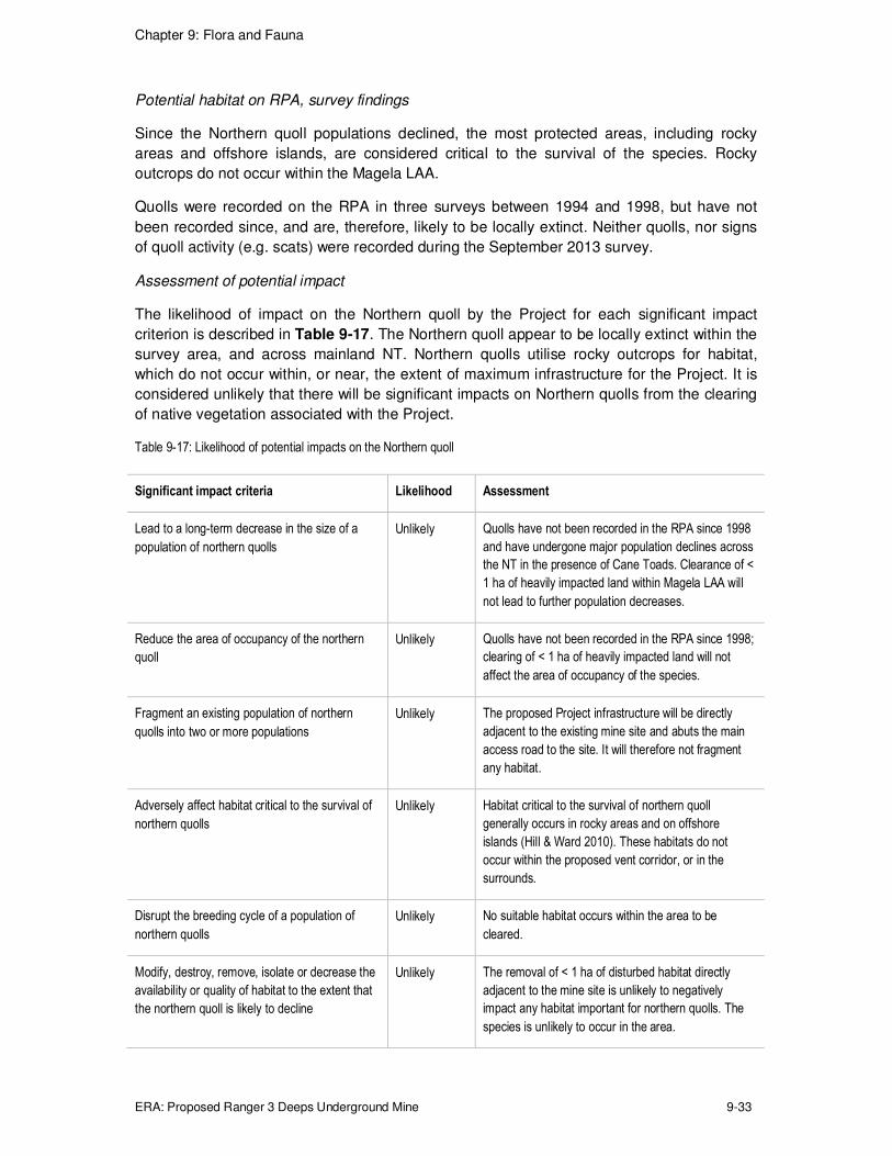
Potential habitat on RPA, survey findings
Since the Northern quoll populations declined, the most protected areas, including rocky
areas and offshore islands, are considered critical to the survival of the species. Rocky
outcrops do not occur within the Magela LAA.
Quolls were recorded on the RPA in three surveys between 1994 and 1998, but have not
been recorded since, and are, therefore, likely to be locally extinct. Neither quolls, nor signs
of quoll activity (e.g. scats) were recorded during the September 2013 survey.
Assessment of potential impact
The likelihood of impact on the Northern quoll by the Project for each significant impact
criterion is described in Table 9-17. The Northern quoll appear to be locally extinct within the
survey area, and across mainland NT. Northern quolls utilise rocky outcrops for habitat,
which do not occur within, or near, the extent of maximum infrastructure for the Project. It is
considered unlikely that there will be significant impacts on Northern quolls from the clearing
of native vegetation associated with the Project.
Table 9-17: Likelihood of potential impacts on the Northern quoll
Significant impact criteria Likelihood Assessment
Lead to a long-term decrease in the size of a
population of northern quolls
Unlikely Quolls have not been recorded in the RPA since 1998
and have undergone major population declines across
the NT in the presence of Cane Toads. Clearance of <
1 ha of heavily impacted land within Magela LAA will
not lead to further population decreases.
Reduce the area of occupancy of the northern
quoll
Unlikely Quolls have not been recorded in the RPA since 1998;
clearing of < 1 ha of heavily impacted land will not
affect the area of occupancy of the species.
Fragment an existing population of northern
quolls into two or more populations
Unlikely The proposed Project infrastructure will be directly
adjacent to the existing mine site and abuts the main
access road to the site. It will therefore not fragment
any habitat.
Adversely affect habitat critical to the survival of
northern quolls
Unlikely Habitat critical to the survival of northern quoll
generally occurs in rocky areas and on offshore
islands (Hill & Ward 2010). These habitats do not
occur within the proposed vent corridor, or in the
surrounds.
Disrupt the breeding cycle of a population of
northern quolls
Unlikely No suitable habitat occurs within the area to be
cleared.
Modify, destroy, remove, isolate or decrease the
availability or quality of habitat to the extent that
the northern quoll is likely to decline
Unlikely The removal of < 1 ha of disturbed habitat directly
adjacent to the mine site is unlikely to negatively
impact any habitat important for northern quolls. The
species is unlikely to occur in the area.

Chapter 9: Flora and Fauna
ERA: Proposed Ranger 3 Deeps Underground Mine 9-34
Significant impact criteria Likelihood Assessment
Result in invasive species that are harmful to a
critically endangered or endangered species
becoming established in northern quoll habitat
Unlikely Current operational pest management systems and
procedures will apply to the development. It is unlikely
that any pest that could impact northern quoll habitat
will be introduced.
Introduce disease that may cause the northern
quolls to decline
Unlikely The proposed action is unlikely to introduce a disease
that would impact northern quolls.
Interfere with the recovery of the northern quoll Unlikely The recovery plan for the northern quoll (Hill & Ward
2010) focuses on mitigating the threat posed by Cane
Toads. The proposed project is unlikely to impact the
spread or density of cane toads already present in the
RPA.
Fawn antechinus (Antechinus bellus)
Regional distribution and ecology
The fawn antechinus is the only species of Antechinus found in the savanna woodland and
tall open forest of the Top End of the NT (Watson & Calaby 2008). The species is restricted
to the NT, largely to the mainland but there is one record of the species from the Tiwi Islands.
The species has been declining in the NT over the past decade due to ongoing inappropriate
fire regimes affecting habitat suitability, and predation by feral cats (Woinarski, et al. 2010).
Potential habitat on RPA, survey findings
The fawn antechinus has been recorded during several previous surveys on the RPA (refer
Figure 2-21, Chapter 2 for locations). Three individuals were recorded during the 2013 Eco
Logical survey – two from remote cameras in the Magela Creek riparian area, and one from
a trap in the Magela LAA (Section 9.2.2).
Assessment of potential impact
The Fawn Antechinus is not listed as threatened under EPBC legislation, and as such the
significant impact guidelines for MNES do not strictly apply. The guidelines are however, a
useful way to address the potential impact of the project on the species and are presented in
Table 9-18.
Although it is considered likely that the area of occupancy of the species will be reduced by a
small amount, the loss of < 1 ha of vegetation is not likely to have a significant impact on the
size of the local populations. Fawn Antechinus were recorded at three locations in woodland
within the survey site, suggesting that the maximum extent of infrastructure for the Project is
not particularly significant habitat for the species, and that there is a population in the
surrounding area that is unlikely to be impacted by the Project
While two of the significant impact criteria are technically considered likely or possible
(reduction of the area of occupancy, and disruption of the breeding cycle), it is considered
unlikely that there will be significant impacts on Fawn antechinus from the clearing of native
vegetation associated with the Project.

Chapter 9: Flora and Fauna
ERA: Proposed Ranger 3 Deeps Underground Mine 9-35
Table 9-18: Likelihood of potential impacts on the fawn antechinus
Significant impact criteria Likelihood Assessment
Lead to a long-term decrease in the size of a
population of fawn antechinus
Unlikely The area to be cleared is a small proportion of suitable
habitat within the RPA. If the population is locally
reduced by clearing, the long term effects should be
mitigated by immigration from the surrounding
woodland.
Reduce the area of occupancy of the fawn
antechinus
Likely The area of occupancy of the fawn antechinus will
likely be reduced by < 1 ha. This does not represent a
significant proportion of suitable habitat in the local
area.
Fragment an existing population of fawn
antechinus into two or more populations
Unlikely The proposed Project infrastructure will be directly
adjacent to the existing mine site and abuts the main
access road to the site. It will therefore not fragment
any fauna population or habitat.
Adversely affect habitat critical to the survival of
fawn antechinus
Unlikely Although the habitat to be cleared may be used by
fawn antechinus, it is not highly suitable unburnt
woodland, and is surrounded by other suitable habitat.
Disrupt the breeding cycle of a population of
fawn antechinus
Possible The species breeds from June to late August, if
clearing takes place during this time period, disruption
of the breeding cycle may take place on a very local
scale within cleared areas.
Modify, destroy, remove, isolate or decrease the
availability or quality of habitat to the extent that
the fawn antechinus is likely to decline
Unlikely The area to be cleared represents a small proportion
of the habitat locally available.
Result in invasive species that are harmful to a
critically endangered or endangered species
becoming established in the fawn antechinus
habitat
Unlikely Current operational pest management systems and
procedures will apply to the development. It is unlikely
that any pest that could impact fawn antechinus habitat
will be introduced.
Introduce disease that may cause the fawn
antechinus to decline
Unlikely Current operational pest management systems and
procedures will apply to the development. It is unlikely
that any disease that could impact fawn antechinus
habitat will be introduced.
Interfere with the recovery of the fawn
antechinus
Unlikely Any impact on the fawn antechinus is likely to be
limited to short term local impacts with no flow on
effects.

Chapter 9: Flora and Fauna
ERA: Proposed Ranger 3 Deeps Underground Mine 9-36
Plains death adder (Acanthophis hawkei)
Regional distribution and ecology
The distribution of the plains death adder is poorly understood; however, the species is
restricted to cracking black soil riverine plains in the north of Australia, from western
Queensland to the northeast of Western Australia. Populations are fragmented, and the
species can be locally common.
Radio tracking suggests that individuals are nomadic, with no fixed home range, and that the
adder travels further distances during the wet season. The species is an ambush predator,
and native frogs make up a large proportion of the diet of smaller individuals, making them
susceptible to cane toads.
Threats to the plains death adder include cane toads and possibly habitat modification from
overgrazing and altered fire regimes.
Potential habitat on RPA, survey findings
No suitable habitat occurs within the RPA and for this reason the September 2013 survey did
not include specific searches for the species.
Assessment of potential impact
The likelihood of impact on the plains death adder by the Project for each significant impact
criterion is described in Table 9-19. It is considered unlikely that there will be significant
impacts on Plains Death Adders from the clearing of native vegetation associated with the
Project.
Table 9-19: Likelihood of potential impacts on the plains death adder
Significant impact criteria Likelihood Assessment
Lead to a long-term decrease in the size of an
important population of plains death adder
Unlikely The above ground impact of the proposed
development will be limited to a small amount of
clearing within a highly disturbed area and is unlikely
to lead to any long term impact on plains death
adders.
Reduce the area of occupancy of an important
population of plains death adder
Unlikely No suitable habitat occurs with the RPA.
Fragment an existing important population of
plains death adder into two or more populations
Unlikely The proposed Project infrastructure will be directly
adjacent to the existing mine site and abuts the main
access road to the site. It will therefore not fragment
any habitat.
Adversely affect habitat critical to the survival of
plains death adder
Unlikely No suitable habitat occurs within the RPA.
Disrupt the breeding cycle of an important
population of plains death adder
Unlikely No suitable habitat occurs within the RPA. Plains
death adders have not been reported in the region.

Chapter 9: Flora and Fauna
ERA: Proposed Ranger 3 Deeps Underground Mine 9-37
Significant impact criteria Likelihood Assessment
Modify, destroy, remove or isolate or decrease
the availability or quality of habitat to the extent
that the plains death adder is likely to decline
Unlikely No suitable habitat occurs within the RPA.
Result in invasive species that are harmful to a
vulnerable species becoming established in the
plains death adder habitat
Unlikely Current operational pest management systems and
procedures will apply to the development. It is
unlikely that any pest that could impact plains death
adders habitat will be introduced.
Introduce disease that may cause the plains
death adder to decline
Unlikely The proposed action is unlikely to introduce a
disease that would impact plains death adders.
Largetooth sawfish (Pristis pristis)
Regional distribution and ecology
The largetooth sawfish has a possible distribution across all major rivers in northern
Australia, from the Fitzroy River in Western Australia, to west Cape York Peninsula in
Queensland (Department of the Environment 2014). The species can be found on sandy or
muddy bottoms of shallow coastal waters, estuaries, river mouths and freshwater rivers and
lakes; generally juveniles are found in fresh water and adults in coastal waters and estuaries
(Stevens, et al. 2005).
Potential habitat on RPA, survey findings
Previous surveys have not found the largetooth sawfish on the RPA. Habitat and species do
not occur on the RPA.
Assessment of potential impact
The biggest threat to sawfish is getting tangled in commercial fishing nets, due to their rostra
(saw), and there is anecdotal evidence of sawfish being caught as by-catch by recreational
fishermen (Stevens, et al. 2008).
The likelihood of impact on the largetooth sawfish by the Project for each significant impact
criterion is described in Table 9-20. It is considered unlikely that there will be significant
impacts on the largetooth sawfish arising from the Project.
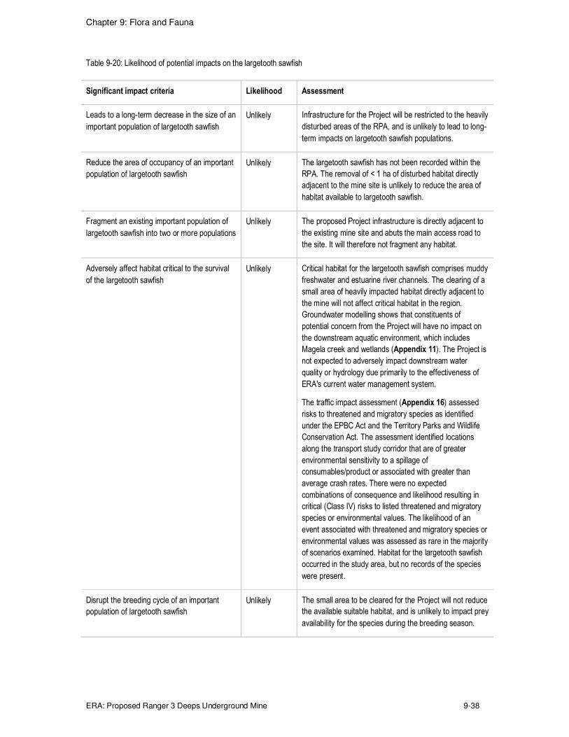
Chapter 9: Flora and Fauna
ERA: Proposed Ranger 3 Deeps Underground Mine 9-38
Table 9-20: Likelihood of potential impacts on the largetooth sawfish
Significant impact criteria Likelihood Assessment
Leads to a long-term decrease in the size of an
important population of largetooth sawfish
Unlikely Infrastructure for the Project will be restricted to the heavily
disturbed areas of the RPA, and is unlikely to lead to long-
term impacts on largetooth sawfish populations.
Reduce the area of occupancy of an important
population of largetooth sawfish
Unlikely The largetooth sawfish has not been recorded within the
RPA. The removal of < 1 ha of disturbed habitat directly
adjacent to the mine site is unlikely to reduce the area of
habitat available to largetooth sawfish.
Fragment an existing important population of
largetooth sawfish into two or more populations
Unlikely The proposed Project infrastructure is directly adjacent to
the existing mine site and abuts the main access road to
the site. It will therefore not fragment any habitat.
Adversely affect habitat critical to the survival
of the largetooth sawfish
Unlikely Critical habitat for the largetooth sawfish comprises muddy
freshwater and estuarine river channels. The clearing of a
small area of heavily impacted habitat directly adjacent to
the mine will not affect critical habitat in the region.
Groundwater modelling shows that constituents of
potential concern from the Project will have no impact on
the downstream aquatic environment, which includes
Magela creek and wetlands (Appendix 11). The Project is
not expected to adversely impact downstream water
quality or hydrology due primarily to the effectiveness of
ERA's current water management system.
The traffic impact assessment (Appendix 16) assessed
risks to threatened and migratory species as identified
under the EPBC Act and the Territory Parks and Wildlife
Conservation Act. The assessment identified locations
along the transport study corridor that are of greater
environmental sensitivity to a spillage of
consumables/product or associated with greater than
average crash rates. There were no expected
combinations of consequence and likelihood resulting in
critical (Class IV) risks to listed threatened and migratory
species or environmental values. The likelihood of an
event associated with threatened and migratory species or
environmental values was assessed as rare in the majority
of scenarios examined. Habitat for the largetooth sawfish
occurred in the study area, but no records of the species
were present.
Disrupt the breeding cycle of an important
population of largetooth sawfish
Unlikely The small area to be cleared for the Project will not reduce
the available suitable habitat, and is unlikely to impact prey
availability for the species during the breeding season.

Chapter 9: Flora and Fauna
ERA: Proposed Ranger 3 Deeps Underground Mine 9-39
Significant impact criteria Likelihood Assessment
Modify, destroy, remove or isolate or decrease
the availability or quality of habitat to the extent
that the largetooth sawfish is likely to decline
Unlikely Critical habitat for largetooth sawfish comprises muddy
freshwater and estuarine river channels. The clearing of a
small area of heavily impacted woodland habitat directly
adjacent to the mine will not affect the availability of quality
of suitable habitat in the region. Groundwater modelling
shows that constituents of potential concern from the
Project will have no impact on the downstream aquatic
environment, which includes Magela Creek and wetlands
(Appendix 11). The Project is not expected to adversely
impact downstream water quality or hydrology due
primarily to the effectiveness of ERA’s current water
management system.
The traffic impact assessment (Appendix 16) assessed
risks to threatened and migratory species as identified
under the EPBC Act and the Territory Parks and Wildlife
Conservation Act. The assessment identified locations
along the transport study corridor that are of greater
environmental sensitivity to a spillage of
consumables/product or associated with greater than
average crash rates. There were no expected
combinations of consequence and likelihood resulting in
critical (Class IV) risks to listed threatened and migratory
species or environmental values. The likelihood of an
event associated with threatened and migratory species or
environmental values was assessed as rare in the majority
of scenarios examined. Habitat for the largetooth sawfish
occurred in the study area, but no records of the species
were present.
Result in invasive species that are harmful to
the largetooth sawfish becoming established in
the vulnerable species' habitat
Unlikely Current operational pest management systems and
procedures will apply to the development. It is unlikely that
any pest that could impact largetooth sawfish habitat will
be introduced
Introduce disease that may cause the
largetooth sawfish to decline
Unlikely Current operational pest management systems and
procedures will apply to the development. It is unlikely that
any pest that could impact largetooth sawfish habitat will
be introduced
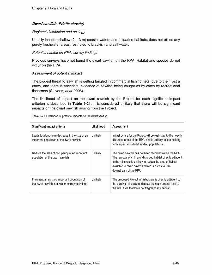
Chapter 9: Flora and Fauna
ERA: Proposed Ranger 3 Deeps Underground Mine 9-40
Dwarf sawfish (Pristis clavata)
Regional distribution and ecology
Usually inhabits shallow (2 – 3 m) coastal waters and estuarine habitats; does not utilise any
purely freshwater areas; restricted to brackish and salt water.
Potential habitat on RPA, survey findings
Previous surveys have not found the dwarf sawfish on the RPA. Habitat and species do not
occur on the RPA.
Assessment of potential impact
The biggest threat to sawfish is getting tangled in commercial fishing nets, due to their rostra
(saw), and there is anecdotal evidence of sawfish being caught as by-catch by recreational
fishermen (Stevens, et al. 2008).
The likelihood of impact on the dwarf sawfish by the Project for each significant impact
criterion is described in Table 9-21. It is considered unlikely that there will be significant
impacts on the dwarf sawfish arising from the Project.
Table 9-21: Likelihood of potential impacts on the dwarf sawfish
Significant impact criteria Likelihood Assessment
Leads to a long-term decrease in the size of an
important population of the dwarf sawfish
Unlikely Infrastructure for the Project will be restricted to the heavily
disturbed areas of the RPA, and is unlikely to lead to long-
term impacts on dwarf sawfish populations.
Reduce the area of occupancy of an important
population of the dwarf sawfish
Unlikely The dwarf sawfish has not been recorded within the RPA.
The removal of < 1 ha of disturbed habitat directly adjacent
to the mine site is unlikely to reduce the area of habitat
available to dwarf sawfish, which is a least 40 km
downstream of the RPA.
Fragment an existing important population of
the dwarf sawfish into two or more populations
Unlikely The proposed Project infrastructure is directly adjacent to
the existing mine site and abuts the main access road to
the site. It will therefore not fragment any habitat.

Chapter 9: Flora and Fauna
ERA: Proposed Ranger 3 Deeps Underground Mine 9-41
Significant impact criteria Likelihood Assessment
Adversely affect habitat critical to the survival
of the dwarf sawfish
Unlikely Critical habitat for the dwarf sawfish comprises shallow
coastal waters and estuarine habitats, which are located at
least 40 km downstream of the RPA. The clearing of a
small area of heavily impacted habitat directly adjacent to
the mine will not affect critical habitat in the region.
Groundwater modelling shows that constituents of
potential concern from the Project will have no impact on
the downstream aquatic environment, which includes
Magela creek and wetlands (Appendix 11). The Project is
not expected to adversely impact downstream water
quality or hydrology due primarily to the effectiveness of
ERA’s current water management system.
The traffic impact assessment (Appendix 16) assessed
risks to threatened and migratory species as identified
under the EPBC Act and the Territory Parks and Wildlife
Conservation Act. The assessment identified locations
along the transport study corridor that are of greater
environmental sensitivity to a spillage of
consumables/product or associated with greater than
average crash rates. There were no expected
combinations of consequence and likelihood resulting in
critical (Class IV) risks to listed threatened and migratory
species or environmental values. The likelihood of an
event associated with threatened and migratory species or
environmental values was assessed as rare in the majority
of scenarios examined. Habitat for the dwarf sawfish
occurred in the study area, but no records of the species
were present.
Disrupt the breeding cycle of an important
population of the dwarf sawfish
Unlikely The small area to be cleared for the Project will not reduce
the available suitable habitat, and is unlikely to impact prey
availability for the species during the breeding season.

Chapter 9: Flora and Fauna
ERA: Proposed Ranger 3 Deeps Underground Mine 9-42
Significant impact criteria Likelihood Assessment
Modify, destroy, remove or isolate or decrease
the availability or quality of habitat to the extent
that the dwarf sawfish is likely to decline
Unlikely Critical habitat for dwarf sawfish comprises shallow coastal
waters and estuarine areas. The clearing of a small area
of heavily impacted woodland habitat directly adjacent to
the mine will not affect the availability of quality of suitable
habitat in the region. Groundwater modelling shows that
constituents of potential concern from the Project will have
no impact on the downstream aquatic environment, which
includes Magela creek and wetlands (Appendix 11). The
Project is not expected to adversely impact downstream
water quality or hydrology due primarily to the
effectiveness of ERA’s current water management system.
The traffic impact assessment (Appendix 16) assessed
risks to threatened and migratory species as identified
under the EPBC Act and the Territory Parks and Wildlife
Conservation Act. The assessment identified locations
along the transport study corridor that are of greater
environmental sensitivity to a spillage of
consumables/product or associated with greater than
average crash rates. There were no expected
combinations of consequence and likelihood resulting in
critical (Class IV) risks to listed threatened and migratory
species or environmental values. The likelihood of an
event associated with threatened and migratory species or
environmental values was assessed as rare in the majority
of scenarios examined. Habitat for the dwarf sawfish
occurred in the study area, but no records of the species
were present.
Result in invasive species that are harmful to
the dwarf sawfish becoming established in the
vulnerable species' habitat
Unlikely Current operational pest management systems and
procedures will apply to the development. It is unlikely that
any pest that could impact dwarf sawfish habitat will be
introduced
Introduce disease that may cause the dwarf
sawfish to decline
Unlikely Current operational pest management systems and
procedures will apply to the development. It is unlikely that
any pest that could impact dwarf sawfish habitat will be
introduced
Northern river shark (Glyphis garricki)
Regional distribution and ecology
The species prefers estuarine habitat. It is known from few records, including in the Northern
Territory from the Adelaide and East and South Alligator River systems.
Potential habitat on RPA, survey findings
Previous surveys have not found the northern river shark on the RPA. Habitat and species
do not occur on the RPA.

Chapter 9: Flora and Fauna
ERA: Proposed Ranger 3 Deeps Underground Mine 9-43
Assessment of potential impact
The likelihood of impact on the northern river shark by the Project for each significant impact
criterion is described in Table 9-22. It is considered unlikely that there will be significant
impacts on the northern river shark arising from the Project.
Table 9-22: Likelihood of potential impacts on the northern river shark
Significant impact criteria Likelihood Assessment
Leads to a long-term decrease in the size of an
important population of the northern river shark
Unlikely Infrastructure for the Project will be restricted to the heavily
disturbed areas of the RPA, and is unlikely to lead to long-
term impacts northern river shark populations.
Reduce the area of occupancy of an important
population of the northern river shark
Unlikely The northern river shark has not been recorded within the
RPA. The removal of < 1 ha of disturbed habitat directly
adjacent to the mine site is unlikely to reduce the area of
habitat available to northern river shark, which is at least
40 km downstream of the RPA.
Fragment an existing important population of
the northern river shark into two or more
populations
Unlikely The proposed Project infrastructure is directly adjacent to
the existing mine site and abuts the main access road to
the site. It will therefore not fragment any habitat.
Adversely affect habitat critical to the survival
of the northern river shark
Unlikely Critical habitat for the northern river shark comprises
estuarine river channels. The clearing of a small area of
heavily impacted habitat directly adjacent to the mine will
not affect critical habitat in the region. Groundwater
modelling shows that constituents of potential concern
from the Project will have no impact on the downstream
aquatic environment, which includes Magela creek and
wetlands (Appendix 11). The Project is not expected to
adversely impact downstream water quality or hydrology
due primarily to the effectiveness of ERA’s current water
management system.
The traffic impact assessment (Appendix 16) assessed
risks to threatened and migratory species as identified
under the EPBC Act and the Territory Parks and Wildlife
Conservation Act. The assessment identified locations
along the transport study corridor that are of greater
environmental sensitivity to a spillage of
consumables/product or associated with greater than
average crash rates. There were no expected
combinations of consequence and likelihood resulting in
critical (Class IV) risks to listed threatened and migratory
species or environmental values. The likelihood of an
event associated with threatened and migratory species or
environmental values was assessed as rare in the majority
of scenarios examined. Habitat for the northern river shark
occurred in the study area, but no records of the species
were present.

Chapter 9: Flora and Fauna
ERA: Proposed Ranger 3 Deeps Underground Mine 9-44
Significant impact criteria Likelihood Assessment
Disrupt the breeding cycle of an important
population of the northern river shark
Unlikely The small area to be cleared for the Project will not reduce
the available suitable habitat, and is unlikely to impact prey
availability for the species during the breeding season.
Modify, destroy, remove or isolate or decrease
the availability or quality of habitat to the extent
that the northern river shark is likely to decline
Unlikely Critical habitat for the northern river shark comprises
estuarine river channels. The clearing of a small area of
heavily impacted woodland habitat directly adjacent to the
mine will not affect the availability of quality of suitable
habitat in the region. Groundwater modelling shows that
constituents of potential concern from the Project will have
no impact on the downstream aquatic environment, which
includes Magela creek and wetlands (Appendix 11). The
Project is not expected to adversely impact downstream
water quality or hydrology due primarily to the
effectiveness of ERA’s current water management system.
The traffic impact assessment (Appendix 16) assessed
risks to threatened and migratory species as identified
under the EPBC Act and the Territory Parks and Wildlife
Conservation Act. The assessment identified locations
along the transport study corridor that are of greater
environmental sensitivity to a spillage of
consumables/product or associated with greater than
average crash rates. There were no expected
combinations of consequence and likelihood resulting in
critical (Class IV) risks to listed threatened and migratory
species or environmental values. The likelihood of an
event associated with threatened and migratory species or
environmental values was assessed as rare in the majority
of scenarios examined. Habitat for the northern river shark
occurred in the study area, but no records of the species
were present.
Result in invasive species that are harmful to
the northern river shark becoming established
in the vulnerable species' habitat
Unlikely Current operational pest management systems and
procedures will apply to the development. It is unlikely that
any pest that could impact northern river shark habitat will
be introduced
Introduce disease that may cause the northern
river shark to decline
Unlikely Current operational pest management systems and
procedures will apply to the development. It is unlikely that
any pest that could impact northern river shark habitat will
be introduced
Speartooth shark (Glyphis glyphis)
Regional distribution and ecology
The species prefers estuarine habitat. It has only been recorded in rivers and estuaries within
Queensland and the Northern Territory, including Adelaide River, South, East and West
Alligator Rivers, Murganella Creek and Marrakai Creek (Stevens, et al. 2005).

Chapter 9: Flora and Fauna
ERA: Proposed Ranger 3 Deeps Underground Mine 9-45
Potential habitat on RPA, survey findings
Previous surveys have not found the speartooth shark on the RPA. Habitat and species do
not occur on the RPA.
Assessment of potential impact
The likelihood of impact on the speartooth shark by the Project for each significant impact
criterion is described in Table 9-23. It is considered unlikely that there will be significant
impacts on the speartooth shark arising from the Project.
Table 9-23: Likelihood of potential impacts on the freshwater sawfish
Significant impact criteria Likelihood Assessment
Leads to a long-term decrease in the size of an
important population of the speartooth shark
Unlikely Infrastructure for the Project will be restricted to the
heavily disturbed areas of the RPA, and is unlikely to
lead to long-term impacts on speartooth shark
populations.
Reduce the area of occupancy of an important
population of the speartooth shark
Unlikely The speartooth shark has not been recorded within the
RPA. The removal of < 1 ha of disturbed habitat directly
adjacent to the mine site is unlikely to reduce the area
of habitat available to speartooth shark, which is at least
40 km downstream of the RPA.
Fragment an existing important population of
the speartooth shark into two or more
populations
Unlikely The proposed Project infrastructure is directly adjacent
to the existing mine site and abuts the main access road
to the site. It will therefore not fragment any habitat.
Adversely affect habitat critical to the survival
of the speartooth shark
Unlikely Critical habitat for the speartooth shark comprises
estuarine areas. The clearing of a small area of heavily
impacted habitat directly adjacent to the mine will not
affect critical habitat in the region. Groundwater
modelling shows that constituents of potential concern
from the Project will have no impact on the downstream
aquatic environment, which includes Magela creek and
wetlands (Appendix 11). The Project is not expected to
adversely impact downstream water quality or hydrology
due primarily to the effectiveness of ERA’s current water
management system.
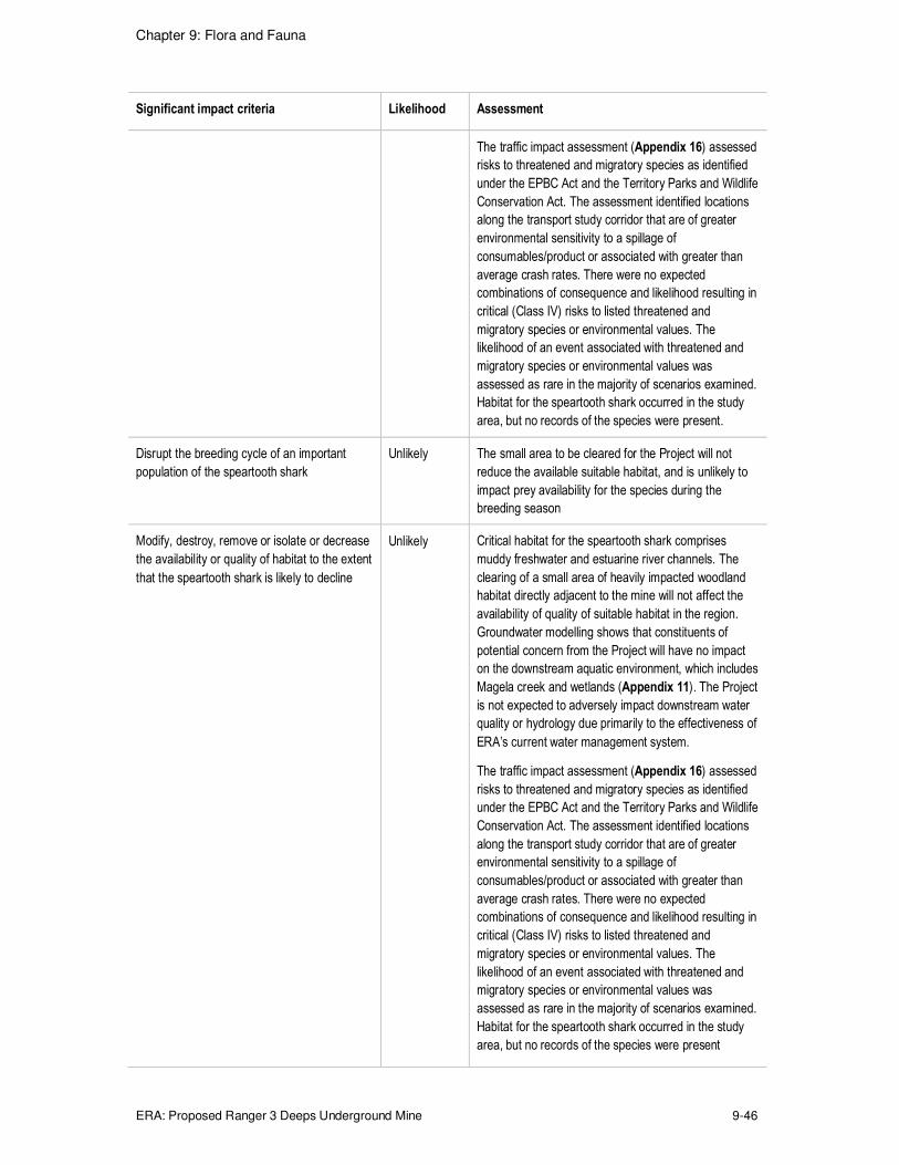
Chapter 9: Flora and Fauna
ERA: Proposed Ranger 3 Deeps Underground Mine 9-46
Significant impact criteria Likelihood Assessment
The traffic impact assessment (Appendix 16) assessed
risks to threatened and migratory species as identified
under the EPBC Act and the Territory Parks and Wildlife
Conservation Act. The assessment identified locations
along the transport study corridor that are of greater
environmental sensitivity to a spillage of
consumables/product or associated with greater than
average crash rates. There were no expected
combinations of consequence and likelihood resulting in
critical (Class IV) risks to listed threatened and
migratory species or environmental values. The
likelihood of an event associated with threatened and
migratory species or environmental values was
assessed as rare in the majority of scenarios examined.
Habitat for the speartooth shark occurred in the study
area, but no records of the species were present.
Disrupt the breeding cycle of an important
population of the speartooth shark
Unlikely The small area to be cleared for the Project will not
reduce the available suitable habitat, and is unlikely to
impact prey availability for the species during the
breeding season
Modify, destroy, remove or isolate or decrease
the availability or quality of habitat to the extent
that the speartooth shark is likely to decline
Unlikely Critical habitat for the speartooth shark comprises
muddy freshwater and estuarine river channels. The
clearing of a small area of heavily impacted woodland
habitat directly adjacent to the mine will not affect the
availability of quality of suitable habitat in the region.
Groundwater modelling shows that constituents of
potential concern from the Project will have no impact
on the downstream aquatic environment, which includes
Magela creek and wetlands (Appendix 11). The Project
is not expected to adversely impact downstream water
quality or hydrology due primarily to the effectiveness of
ERA’s current water management system.
The traffic impact assessment (Appendix 16) assessed
risks to threatened and migratory species as identified
under the EPBC Act and the Territory Parks and Wildlife
Conservation Act. The assessment identified locations
along the transport study corridor that are of greater
environmental sensitivity to a spillage of
consumables/product or associated with greater than
average crash rates. There were no expected
combinations of consequence and likelihood resulting in
critical (Class IV) risks to listed threatened and
migratory species or environmental values. The
likelihood of an event associated with threatened and
migratory species or environmental values was
assessed as rare in the majority of scenarios examined.
Habitat for the speartooth shark occurred in the study
area, but no records of the species were present

Chapter 9: Flora and Fauna
ERA: Proposed Ranger 3 Deeps Underground Mine 9-47
Significant impact criteria Likelihood Assessment
Result in invasive species that are harmful to
the speartooth shark becoming established in
the vulnerable species' habitat
Unlikely Current operational pest management systems and
procedures will apply to the development. It is unlikely
that any pest that could impact speartooth shark habitat
will be introduced
Introduce disease that may cause the
speartooth shark to decline
Unlikely Current operational pest management systems and
procedures will apply to the development. It is unlikely
that any pest that could impact speartooth shark habitat
will be introduced
9.2.3.2 Migratory Species
A description of the studies and surveys that have been undertaken in the RPA are
described in Section 9.2. No survey methods specific to the requirements of migratory
species were employed.
An assessment was conducted (based on the likelihood assessment) of the migratory
species identified that may be impacted by the Project. The following sections address 15
migratory bird and one migratory reptile species that are known or considered likely to occur
on the RPA, or require assessment under the EIS guidelines.
Cattle egret (Ardea ibis)
Regional distribution and ecology
The cattle egret occurs in tropical and temperate grasslands, wooded lands and terrestrial
wetlands around the world. Two major distributions have been located within Australia:
� Northeast Western Australia to the Top End.
� Southeast Australia.
In Western Australia and the NT, the species is located from Wyndham to Arnhem Land,
where it breeds in colonies. The species feeds on insects and small reptiles, amphibians and
mammals.
Major threats facing the cattle egret include persecution of large colonies in urban areas, loss
of breeding habitats through wetland degradation and destruction, hunting, and in Australia,
exotic species, especially feral cats.
Potential habitat on RPA, survey findings
The RPA is not key habitat for the cattle egret. However, a cattle egret was observed at
Georgetown Billabong on one day during the September 2013 survey. No breeding sites
have been identified on the RPA.
Common sandpiper (Actitis hypoleucos)
Regional distribution and ecology

Chapter 9: Flora and Fauna
ERA: Proposed Ranger 3 Deeps Underground Mine 9-48
The common sandpiper is broadly distributed internationally and occurs throughout Darwin
and Kakadu National Park as well as in Western Australian and Queensland; it is widespread
in small numbers. The bird is found along the coastline as well as many inland areas. More
specifically, it is found within a wide range of coastal, and some inland, wetlands, with
varying levels of salinity, and is mostly found around muddy margins or rocky shores, but
rarely on mudflats. The common sandpiper has been recorded in estuaries and stream
deltas, as well as on banks farther upstream; around lakes, pools, billabongs, reservoirs,
dams and claypans. The muddy margins utilised by the species are often narrow, and may
be steep. The species is often associated with mangroves, and sometimes found in areas of
mud littered with rocks or snags. The common sandpiper breeds in Eurasia and moves south
for the Arctic winter, with the eastern breeding populations wintering in south Asia to
Melanesia and Australia.
In Australia, major threats facing the common sandpiper include habitat loss, reduction of
quality and quantity of water, global warming and disturbances from human activities, e.g.
fishing and aquaculture.
Potential habitat on RPA, survey findings
The RPA is not key habitat for the common sandpiper. No breeding sites have been
identified on the RPA and the species was not observed during the September 2013 survey.
Derby white-browed robin (Poecilodryas superciliosa cerviniventris)
Regional distribution and ecology
The Derby white-browed robin has a broad distribution across the northern NT and is found
in woodlands, forests and wetlands. Known and perceived threats to the species include
agriculture, aquaculture, habitat alteration due to trampling and grazing by livestock, and
predation, competition, habitat degradation and/or spread of pathogens by introduced
species.
Potential habitat on RPA, survey findings
The RPA is not key habitat for the Derby white-browed robin. No breeding sites have been
identified within the survey area and the species was not observed during the September
2013 survey.
Eastern Great Egret (Ardea modesta)
Regional distribution and ecology
The eastern great egret is widespread in Australia, occurring in all states and territories,
where the largest breeding colonies, and greatest concentrations of breeding colonies, are
located in near-coastal regions of the Top End. This species roosts in large flocks that may
consist of hundreds of birds. The Eastern grey egret has been reported in a wide range of
wetland habitats, e.g., inland and coastal, freshwater and saline. In Australia, breeding sites
are located in wooded and shrubby swamps including mangrove forests (the main habitat of
the species in the Top End). The egret has a diverse diet that includes fish, insects, reptiles,
small birds and mammals.

Chapter 9: Flora and Fauna
ERA: Proposed Ranger 3 Deeps Underground Mine 9-49
In Australia, major threats facing the eastern great egret include loss and/or degradation of
foraging, and especially breeding, habitat through alteration of water flows, drainage and/or
clearing of wetlands for development, frequent burning of wetland vegetation used as nest
sites, salinisation and invasion by exotic plants.
Potential habitat on RPA, survey findings
The RPA is not key habitat for the eastern great egret. However, Eastern great egrets were
observed at Georgetown Billabong on four days during the September 2013 survey and at
RP1 on one day.
Grey plover (Pluvialis squatarola)
Regional distribution and ecology
The grey plover is a migratory wading species, breeding in tundra at the northern
hemisphere and flying south for the boreal winter. In non-breeding grounds in Australia, grey
plovers occur almost entirely in coastal areas, where forage on large areas of exposed
mudflats and beaches of sheltered coastal shores such as inlets, estuaries and lagoons. The
species is also very occasionally recorded further inland, where they occur around wetlands
or salt-lakes
In Australia, threats to the grey plover (includes all migratory waders) includes pollution,
habitat reduction, disturbance from tourism, recreation, aquaculture, spread of weeds such
as Spartinia on intertidal mudflats.
Potential habitat on RPA, survey findings
The RPA is not key habitat for the grey plover and the species was not observed during the
September 2013 survey.
Marsh sandpiper (Tringa stagnatilis)
Regional distribution and ecology
The marsh sandpiper is found on coastal and inland wetlands throughout Australia. The
species is widespread in coastal Queensland, but few records exist north of Cooktown.
There are scattered records of the bird in Western Australia and the NT.
The species lives in permanent or ephemeral wetlands of varying salinity, including swamps,
lagoons, billabongs, saltpans, saltmarshes, estuaries, pools on inundated floodplains, and
intertidal mudflats. In north Australia, they prefer intertidal mudflats, although surveys in
Kakadu National Park recorded more birds around shallow freshwater lakes than in areas
influenced by the tide. In the Top End, they often use ephemeral pools on inundated
freshwater and tidal floodplains and are found infrequently around mangroves. They occur
singly or in small to large flocks, are often associated with other waders and are often seen
with greenshanks, especially in salt fields. The species breeds in areas from eastern
European to eastern Siberia.
In Australia, threats to the marsh sandpiper include habitat loss and degradation, disturbance
and direct mortality (e.g., as a result of human activities such as wind farm construction).

Chapter 9: Flora and Fauna
ERA: Proposed Ranger 3 Deeps Underground Mine 9-50
Potential habitat on RPA, survey findings
The RPA is not key habitat for the marsh sandpiper and the species was not observed during
the September 2013 survey.
Melville cicadabird (Coracina tenuirostris melvillensis)
Regional distribution and ecology
The Melville cicadabird occurs in northern Australia from Broome in WA to the far eastern
Top End. The bird uses foliage in the canopy of diverse forests and woodlands, including
mangroves and paperbark swamps. Melville cicadabirds feed on insects and breed from
September to June (peaking during November to February), building high nests below the
canopy.
Known and perceived threats to the species include agriculture, aquaculture, land clearing,
habitat fragmentation and habitat degradation.
Potential habitat on RPA, survey findings
The RPA is not key habitat for the Melville cicadabird and the species was not observed
during the September 2013 survey.
Oriental plover (Charadrius veredus)
Regional distribution and ecology
The oriental plover is widely distributed across Australia during the northern hemisphere's
winter as a non-breeding visitor to Australia during this time. The entire world population
breeds in a restricted area centred on Mongolia and adjacent areas of south-eastern Siberia
and north-eastern China.
In Australia, the species occurs in both coastal and inland areas, mostly in northern Australia.
Most records are along the north-western coast, between Exmouth Gulf and Derby in
Western Australia, and there are records at a few scattered sites elsewhere, mainly along the
northern coast, such as in the Top End, the Gulf of Carpentaria and on Cape York Peninsula.
Lake Sylvester, a system of ephemeral lakes about 180 km north east of Tennant Creek, is
one of six internationally important sites for the oriental plover within the NT. None of these
sites is in a conservation reserve, and two are within commercial salt works.
Although there are no threats that apply specifically to oriental plovers, there are a number of
threats that affect all migratory waders. In Australia, the species occurs in sparsely-settled
areas, and there are no immediate threats to its survival. Little is known about the inland
ephemeral wetlands that occur over vast areas of northern Australia, nor about the effects of
grazing on this species' grassland habitat.

Chapter 9: Flora and Fauna
ERA: Proposed Ranger 3 Deeps Underground Mine 9-51
Potential habitat on RPA, survey findings
The RPA is not key habitat for the oriental plover and the species was not observed during
the September 2013 survey.
Oriental pratincole (Glareola maldivarum)
Regional distribution and ecology
The oriental pratincole is widespread throughout Australia and in the northern areas,
especially along the coasts of the Pilbara and Kimberley regions in Western Australia, the
Top End of the NT, and parts of the Gulf of Carpentaria. It is also widespread but scattered
inland, mostly north of 20°S. The species has also been recorded on various outlying islands,
including Lord Howe Island, and Christmas Island and Cocos-Keeling Islands in the Indian
Ocean. Within the NT, nationally important sites include Lake De Burgh, Lake Woods and
Lake Sylvester.
Most birds are thought to spend the non-breeding season in Australia, arriving between late
October and early November, and departing mid-March to early April.
There are no immediate threats to the species as it mostly occurs within sparsely-settled
areas.
Potential habitat on RPA, survey findings
The RPA is not key habitat for the oriental pratincole and the species was not observed
during the September 2013 survey.
Rainbow bee-eater (Merops ornatus)
Regional distribution and ecology
The rainbow bee-eater is distributed across much of mainland Australia, and occurs on
several near-shore islands. The population size has not been determined but is assumed to
be reasonably large based on reporting rates for the species.
The rainbow bee-eater occurs mainly in open forests and woodlands, shrublands, various
cleared or mangroves. Nests are constructed in an enlarged chamber at the end of long
burrow or tunnel that is excavated, by both sexes, in flat or sloping ground, in the banks of
rivers, creeks or dams, in roadside cuttings, in the walls of gravel pits or quarries, in mounds
of gravel, or in cliff-faces. The rainbow bee-eater mainly feeds on insects.
The only identified threat to the rainbow bee-eater is the cane toad, which reduces the
breeding success and productivity of the species by feeding on eggs and especially
nestlings, and usurping and occupying nesting burrows.
Potential habitat on RPA, survey findings
Vegetation within and surrounding the RPA provides habitat for the rainbow bee-eater. The
species was observed at Georgetown Billabong, in five transects and in the Magela Creek
bed throughout the September 2013 survey period; however, no breeding sites were
identified.

Chapter 9: Flora and Fauna
ERA: Proposed Ranger 3 Deeps Underground Mine 9-52
Rufous fantail (Rhipidura rufifrons)
Regional distribution and ecology
The rufous fantail occurs in coastal and near coastal districts of northern and eastern
Australia and has breeding populations occurring from about the South Australia-Victoria
border, through to the Cairns-Atherton region of Queensland. The rufous fantail is considered
a common and secure species that is usually seen singly or in pairs, but occasionally in small
groups. In north and north-eastern Australia, the birds often occur in tropical and monsoon
rainforests.
The species breeds from approximately September to February and are insectivorous,
foraging mainly in the low to middle strata of forests.
The main threats to rufous fantail populations are habitat fragmentation and loss of core
moist forest breeding habitat through land clearing and urbanisation, particularly in forest
remnants and corridors along the species' migration routes.
Potential habitat on RPA, survey findings
The RPA is not key habitat for the rufous fantail and the species was not observed during the
September 2013 survey.
Terek sandpiper (Xenus cinereus)
Regional distribution and ecology
The Terek sandpiper has a primarily coastal distribution, with occasional records inland. It is
more widespread and common in northern and eastern Australia than southern Australia. In
the NT, widespread records occur from Darwin, north to Melville Island, and east to the
western section of the Gulf of Carpentaria, around Gove Peninsula, Groote Eylandt, Sir
Edward Pellew Islands and the mouth of the McArthur River. Sites of international
significance in the NT include Chambers Bay, Fog Bay and adjacent islands, and the
Milingimbi coast.
The species mostly forages in the open, on soft wet intertidal mudflats or in sheltered
estuaries, embayments, harbours or lagoons and has also been recorded on islets,
mudbanks, sandbanks and spits, and near mangroves. Terek sandpipers are occasionally
sighted around drying sewage ponds and saltpans, if surrounded by mudflats, and less often
seen on sandy or shingle beaches, or on rock or coral reefs or platforms. The species is also
found around brackish coastal swamps, lagoons and dune-lakes, and also on gravel or rocky
edges of estuarine pools and freshwater river pools.
Threats to the species include habitat loss, disturbance and climate change.
Potential habitat on RPA, survey findings
The RPA is not key habitat for the Terek sandpiper and the species was not observed during
the September 2013 survey.
Chapter 9: Flora and Fauna
ERA: Proposed Ranger 3 Deeps Underground Mine 9-53
Whimbrel (Numenius phaeopus)
Regional distribution and ecology
The whimbrel is a regular migrant to Australia (non-breeding in Australia) and New Zealand,
primarily with a coastal distribution, but there are also scattered inland records of the species
in all regions. The bird is found in all states but is more common in northern Australia. It has
been found around the coasts of the Top End, where it sometimes follows rivers inland and is
commonly widespread from Carnarvon to the northeast Kimberley Division, Western
Australia. Some of the scattered records elsewhere show the species as a regular visitor to
islands off Western Australia, NT, Queensland, New Zealand and France. Chambers Bay in
the NT is a site of international significance for the species. The southward migration of the
species to Australia is to escape severe winter conditions and the consequent high energy
demand that cannot be met by low prey availability.
The species is often found on the intertidal mudflats of sheltered coasts and is found in
harbours, lagoons, estuaries and river deltas, often those with mangroves, but also open,
unvegetated mudflats. It is occasionally found on sandy or rocky beaches, on coral or rocky
islets, or on intertidal reefs and platforms. It has been infrequently recorded using saline or
brackish lakes near coastal areas and salt flats with saltmarsh, or saline grasslands with
standing water left after high spring tides, and in similar habitats in sewage farms and salt
fields.
In Australia, threats to the whimbrel include habitat loss and degradation, disturbance and
direct mortality.
Potential habitat on RPA, survey findings
The RPA is not key habitat for the whimbrel and the species was not observed during the
September 2013 survey.
White-bellied sea-eagle (Haliaeetus leucogaster)
Regional distribution and ecology
The white-bellied sea-eagle is distributed along the coastline (including offshore islands) of
Asia, Oceania and mainland Australia and Tasmania, and also extends inland along some of
the larger waterways, especially in eastern Australia. Breeding records are patchily
distributed, mainly along the coastline also, especially the eastern coast, extending from
Queensland to Victoria, and to Tasmania.
This species is found in coastal habitats and around terrestrial wetlands in tropical and
temperate regions of mainland Australia and its offshore islands. Breeding territories are
located close to water, and mainly in tall open forest or woodland. The eagle feeds
opportunistically on a variety of fish, birds, reptiles, mammals and crustaceans, and on
carrion and offal.
The main threats to the species are loss of habitat due to land development, and disturbance
of nesting pairs by human activity.

Chapter 9: Flora and Fauna
ERA: Proposed Ranger 3 Deeps Underground Mine 9-54
Potential habitat on RPA, survey findings
The RPA provides suitable habitat for the white-bellied sea-eagle. A breeding pair of white-
bellied sea-eagles was observed at Georgetown Billabong throughout the September 2013
survey.
Saltwater crocodile (Crocodylus porosus)
Regional distribution and ecology
The saltwater crocodile is a large member of the Crocodylidae family and is found in
Australian coastal waters, estuaries, freshwater sections of lakes, inland swamps and
marshes. The species' distribution is widespread across northern Australian and ranges from
Rockhampton in Queensland throughout coastal NT to King Sound (near Broome) in
Western Australia. In the NT, the saltwater crocodile has been found in many rivers including
the Mary, Adelaide, Daly and Moyle rivers. Elevated isolated freshwater swamps that are not
influenced by the tide are the preferred nesting habitat for the saltwater crocodile.
The species feeds on crustaceans, insects and mammals.
In Australia, threats to the saltwater crocodile include incidental mortality from fishing nets,
habitat destruction and, in Arnhem Land, destruction of wetland habitat by feral animals such
as pigs and buffalo.
Potential habitat on RPA, survey findings
The RPA provides suitable habitat for the saltwater crocodile. A saltwater crocodile was
observed at Georgetown Billabong in October 2013. No breeding sites have been identified
on the RPA.
The likelihood of impact on migratory species by the Project for each significant impact
criterion is summarised in Table 9-24.
Likelihood of impact
Table 9-24: Likelihood of potential impacts on migratory species
Significant impact criteria Likelihood Assessment
Substantially modify, destroy or isolate an area
of important habitat for migratory species
Unlikely The removal of disturbed habitat directly adjacent to the
mine site is unlikely to negatively impact any habitat
important for migratory species
Result in an invasive species that is harmful to
the migratory species becoming established in
an area of important habitat for migratory species
Unlikely Current operational pest management systems and
procedures will apply to the development. It is unlikely that
any pest that could impact migratory species will be
introduced.
Seriously disrupt the lifecycle of an ecologically
significant proportion of the populations of
migratory species
Unlikely The proposed area of disturbance has not been identified
as a key habitat for migratory species

Chapter 9: Flora and Fauna
ERA: Proposed Ranger 3 Deeps Underground Mine 9-55
9.3 RADIATION RISKS TO ENVIRONMENT
The risk assessment and management of radionuclides entering or present in the
environment has historically been based on human health considerations alone. This
approach has been underpinned by the International Commission of Radiological Protection
(ICRP) recommendations that state “if man is protected then it can be assumed that the
environment is protected” (ICRP 1991).
More recently, there has been increasing awareness of the potential vulnerability of the
environment and of the need to be able to demonstrate that it is protected against the effects
of industrial pollutants, including radionuclides. The ICRP, in its recent publications (ICRP
2007; 2008), has addressed this issue by recommending that assessments of the risk from
radiation to animals and plants be undertaken.
In 2007, the ERICA tool was developed to assist in the assessment of radiological risk to
plants and animals (Beresford, et al. 2007). The software system is structured on the ERICA
Integrated Approach, which is a three tiered system comprising generic screening, detailed
screening and site-specific analysis. The tool guides the user through the assessment
process, recording information and decisions and allowing the necessary calculations to be
performed to estimate risks to selected animals and plants.
In a report by the Australian Radiation Protection and Nuclear Safety Agency (ARPANSA)
(Doering 2010), the ERICA tool was described as a practical framework for assessing risk to
non-human species that could potentially be adapted to Australian situations. This included
the uranium mining industry as part of the need to integrate best practice standards for
assessing environmental impacts.
The ERICA tool has been used to conduct an assessment of radiation risk to both terrestrial
and aquatic plants and animals. To quantify the risk, the tool calculates the effective radiation
dose rate to a range of representative organisms (plants and animals). This dose rate is then
compared to a screening dose-rate of 10 µGy/h 8 to obtain a risk quotient. Risk quotients are
presented both for the "expected value" and a "conservative value". The expected value is
the ratio of the estimated dose rate to the screening dose rate; the conservative value is
three times higher than the expected value and represents the 95th percentile of the dose
rate distribution, providing an additional layer of conservatism to the assessment and
confidence that the environment will be protected.
Where the ERICA tool shows all risk quotients to be less than one, it can be concluded that
there is no increased risk to the environment. Where this is not the case, then a review of
effects data specific to that organism should be undertaken to qualify if there is a potential
risk. Where the effects data indicate there is a potential risk to that organism, further
assessment needs to be undertaken.
The assessment for the terrestrial environment focussed on the highest potential impact
area, close to the Project footprint and within the RPA. The aquatic assessment assessed
8 This screening dose rate is also described as the predicted no-effect dose rate. It has been derived from a large radiation
effects database and statistically represents the dose rate at which 95% of species will be protected. This screening rate
is thus expected to protect the most radiosensitive organisms likely to be present in an environment (Garnier-Laplace, et
al. 2008).

Chapter 9: Flora and Fauna
ERA: Proposed Ranger 3 Deeps Underground Mine 9-56
impact in Magela Creek downstream of Ranger mine at gauging station MG009. The results
of both assessments demonstrate the risk to plants and animals in terrestrial and aquatic
habitats from the Project are negligible. Full details of the assessment are provided in
Appendix 8 Radiation with a summary of the results provided herein.
9.3.1 Problem Formulation and Conceptual Models
The first step in any risk assessment is the problem formulation phase, for ecological risk
assessments this includes developing conceptual models for transfer of contaminants into
the environment. The conceptual models for aquatic and terrestrial pathways that formed the
basis for the ERICA assessment are provided in Figure 9-9 and Figure 9-10.
The aquatic pathway for the transfer of radionuclides into the environment is the same as
that for current operations; excess water from the underground mining operations will be sent
to RP2 and therefore contained within the current water management system, refer
Chapter 8. As described in Chapter 8, excess pond water will be treated; with clean
permeate water9 being irrigated to the land application areas during the dry season and
discharged to either RP1 or the Corridor Creek wetland filter during the wet season, ahead of
release to the Magela Creek system. During the wet season, surface water runoff from the
land application areas discharges into the Magela Creek system. Since the concentration of
contaminants in permeate water will remain unchanged with the introduction of Ranger 3
Deeps, it is not possible to distinguish between incremental and existing operational sources.
Therefore, a cumulative assessment was undertaken for the aquatic pathway.
The pathway for exposure to the terrestrial environment will be through dust emissions from
new Project sources and its deposition onto local soils. Dust deposition from the Project has
been predicted through the use of an air quality model; refer Appendix 6.
Various organisms present in the environment were also identified as part the conceptual
models. This was done by matching the reference organisms in the ERICA tool with
organisms known to be in the area surrounding the RPA (Kakadu National Park). Matching is
based on the type of species, its habitation, size and shape compared to that of each
reference organism.10 When selecting an example local species for assessment, the following
hierarchy was used; endangered or threatened species, species considered to have cultural
significance, species known to bioaccumulate radionuclides, or a general example of typical
species found in the local area.
Several species in the local area did not match any of the reference organisms and were
considered important enough to require the development of a specific “new” organism. One
reference organism had no matches to local species; this was the large terrestrial mammal
(deer); however, in Australia deer are not (naturally) present and this ecological niche is filled
with macropods (kangaroos and wallabies). The assessment was therefore done using data
for the agile wallaby (macropus agilis), a common species on the RPA.
9 Permeate is a class of mine water that has been treated through one of three existing water treatment plants at Ranger
mine.
10 Details of each reference organism are provided in the ERICA tool help file.

Chapter 9: Flora and Fauna
ERA: Proposed Ranger 3 Deeps Underground Mine 9-57
Figure 9-9: Conceptual model for terrestrial assessment
Figure 9-10: Conceptual model for aquatic assessment
9.3.2 Environmental Media Concentrations
The conceptual models were used to estimate the radionuclide concentrations in the soil or
water in which the plants and animals live (termed the environmental media concentrations).
For the aquatic assessment, the environmental media concentrations were determined from
the historic Magela Creek monitoring data, collected by ERA and the Supervising Scientist,
for uranium and radium respectively. This was used to calculate a wet season median
difference between upstream and downstream concentrations. The media concentration for
this assessment was taken as the worst case (highest) year from the past 11 wet seasons.

Chapter 9: Flora and Fauna
ERA: Proposed Ranger 3 Deeps Underground Mine 9-58
In addition to the water concentration, the aquatic assessment requires a media
concentration for creek or billabong sediment. This parameter can either be entered or the
tool can determine the concentration based on the input water concentration and the use of a
water-to-sediment distribution coefficient (Kd). For this assessment a set of site specific Kd
values were used (Murray, et al. 1992).
For the terrestrial assessment, the increase in soil radionuclide concentrations was estimated
from the results of air quality modelling (refer Appendix 6). This modelling showed an
incremental annual average dust deposition rate over the Project area of 0.2 g/m2/month.
Assuming a five-year Project life and a soil mixing depth of 10 mm, it was estimated that
there will be a small Project-related increase of 11 Bq/kg in soils for each radionuclide in the 238U series.
9.3.3 Concentration Ratios
The activity concentrations of radionuclides in biota were predicted in the ERICA tool from
media activity concentrations and concentration ratios. Concentration ratios represent the
ratio of organism whole body radionuclide activity concentration in fresh weight, compared to
the activity concentration of that radionuclide in the media (soil or water) where the organism
lives. For a terrestrial assessment, this is the Bq/kg whole organism (fresh weight) per Bq/kg
soil (dry weight). For an aquatic assessment, this is the Bq/kg whole organism (fresh weight)
per Bq/L in water (filtered).
Where possible, site specific concentration ratios were obtained from the Supervising
Scientist (Doering, et al. 2012; Ryan, et al. 2009). The ERICA tool requires concentration
ratios for the whole organism; however, some of the concentration ratios available were for
muscle or flesh only. For these cases, the whole organism concentration ratio was obtained
by applying whole-body to tissue ratios published by Yankovich et al (2010). Where site
specific data was not available, the ERICA tool was used to derive appropriate values.11
9.3.4 Assessment Results
The results for the aquatic assessment are provided in Table 9-25. This shows all organisms
to have dose rates below the screening level of 10 µGy/h; however, for one organism
(Bivalve mussel, or the local species of freshwater mussel) the conservative risk quotient
was greater than 1, indicating a potential risk of radiological effects that requires more
detailed review of specific effects data.
Reviewing the specific effects data for mussels in UNSCEAR (1996) shows that cumulative
doses of 80 – 88 Gy, at dose rates as high as 9,000 – 10,000 Gy/h, had no effect on juvenile
molluscs (scallops and clams). In the same report, it was concluded that for aquatic
organisms, dose rates below 400 µGy/h would have not detrimental effects at the population
level.
11 The ERICA tool contains an entire wildlife transfer database which can provide measured concentration ratios for
organism-radionuclide combinations or estimate them using one of several accepted methods.

Chapter 9: Flora and Fauna
ERA: Proposed Ranger 3 Deeps Underground Mine 9-59
More site specific data for mussels in the Magela Creek system shows that the radium load
(and consequently the resulting dose rate) in the population of mussels from Bowerbird
Billabong, 20 km upstream of the Ranger mine is substantially greater than that downstream
(Bollhöfer, et al. 2011). The higher dose rates received by these mussels does not appear to
have impacted on their population in this billabong, indicating that the lower dose rates from
mine sources to downstream mussels will also not have any effects to the population.
Based on this, it has been concluded that the estimated dose rates of <5 µGy/h will not pose
any risk to populations of mussels in Magela Creek downstream of Ranger mine from the
cumulative discharges of treated water. Likewise, the potential impact on other aquatic
organisms is negligible.
The results for the terrestrial assessment are provided in Table 9-26, which shows that the
risk to terrestrial organisms from the Project is insignificant, with all organisms having dose
rates below the screening level of 10 µGy/h and conservative risk quotients less than 1.
Table 9-25: Dose rates and risk quotients for aquatic pathway
Reference organism Dose rate (µGy/h)
Risk Quotient (expected value)
Risk Quotient (conservative value)
Bivalve mollusc 4.76 0.476 1.429
Insect larvae 0.54 0.054 0.162
Phytoplankton 0.46 0.046 0.137
Turtle1 0.37 0.037 0.112
Vascular plant 0.35 0.035 0.104
Crustacean 0.32 0.032 0.097
Crocodile1 0.11 0.011 0.034
Waterlily1 0.09 0.009 0.028
Pelagic fish 0.09 0.009 0.027
Water monitor1 0.09 0.009 0.028
Filesnake1 0.07 0.007 0.020
Aquatic mammal 0.06 0.006 0.019
Bird 0.03 0.003 0.010
Benthic fish 0.03 0.003 0.010
Amphibian 0.01 0.001 0.003
1 New organism created for site specific assessment
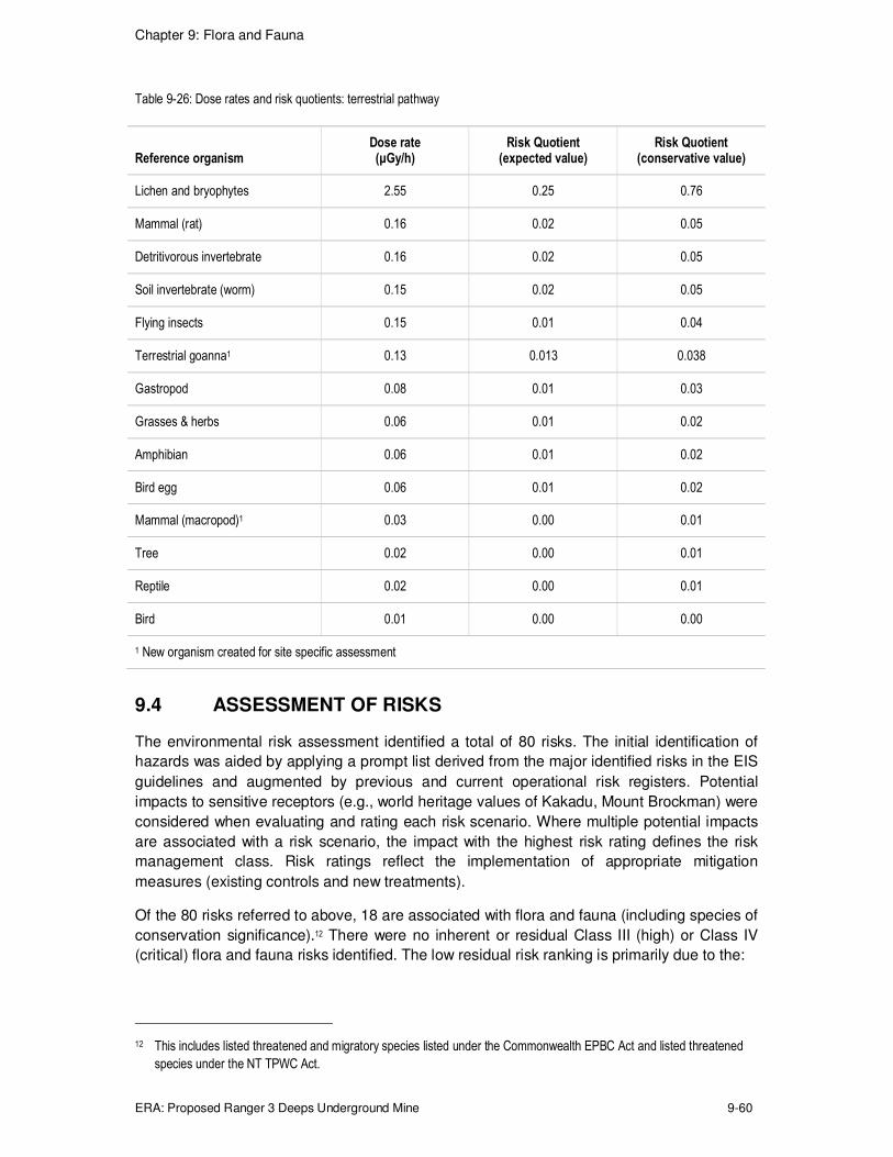
Chapter 9: Flora and Fauna
ERA: Proposed Ranger 3 Deeps Underground Mine 9-60
Table 9-26: Dose rates and risk quotients: terrestrial pathway
Reference organism Dose rate (µGy/h)
Risk Quotient (expected value)
Risk Quotient (conservative value)
Lichen and bryophytes 2.55 0.25 0.76
Mammal (rat) 0.16 0.02 0.05
Detritivorous invertebrate 0.16 0.02 0.05
Soil invertebrate (worm) 0.15 0.02 0.05
Flying insects 0.15 0.01 0.04
Terrestrial goanna1 0.13 0.013 0.038
Gastropod 0.08 0.01 0.03
Grasses & herbs 0.06 0.01 0.02
Amphibian 0.06 0.01 0.02
Bird egg 0.06 0.01 0.02
Mammal (macropod)1 0.03 0.00 0.01
Tree 0.02 0.00 0.01
Reptile 0.02 0.00 0.01
Bird 0.01 0.00 0.00
1 New organism created for site specific assessment
9.4 ASSESSMENT OF RISKS
The environmental risk assessment identified a total of 80 risks. The initial identification of
hazards was aided by applying a prompt list derived from the major identified risks in the EIS
guidelines and augmented by previous and current operational risk registers. Potential
impacts to sensitive receptors (e.g., world heritage values of Kakadu, Mount Brockman) were
considered when evaluating and rating each risk scenario. Where multiple potential impacts
are associated with a risk scenario, the impact with the highest risk rating defines the risk
management class. Risk ratings reflect the implementation of appropriate mitigation
measures (existing controls and new treatments).
Of the 80 risks referred to above, 18 are associated with flora and fauna (including species of
conservation significance).12 There were no inherent or residual Class III (high) or Class IV
(critical) flora and fauna risks identified. The low residual risk ranking is primarily due to the:
12 This includes listed threatened and migratory species listed under the Commonwealth EPBC Act and listed threatened
species under the NT TPWC Act.
Chapter 9: Flora and Fauna
ERA: Proposed Ranger 3 Deeps Underground Mine 9-61
� majority of new infrastructure being located on the inside of the mine access road,
thereby reducing impacts associated with land disturbance; and
� removal of < 1 ha of disturbed habitat directly adjacent to the mine site, which is
unlikely to reduce the area or quality of habitat for flora and fauna.
Section 9.5 discusses flora and fauna risks of particular interest to stakeholders and/or
where additional treatments have been identified. A description of the risk assessment
method is provided in Chapter 5. Additional discussion of the risks associated with the
Project is provided in Appendix 5.
9.5 MITIGATION
As previously outlined, a number of additional treatments were identified during the risk
assessment to further reduce impacts such as habitat degradation and/or habitat loss and
injury/mortality to fauna. Only mitigation measures directly associated with flora and fauna
are discussed below.
9.5.1 Habitat Degradation and/or Habitat Loss
There are several additional controls to reduce impacts resulting in habitat degradation
and/or loss that may occur through emissions (e.g., dust deposition: risks TA1-01 and TA5-
02; and noise: risk TA3-02), creek flow issues (risk TB6-03), radiation contamination (risk
TF3-02), and clearing (risk TA1-02), and light amenity (risk TA5-03). These include:
� Implementing new monitoring at sensitive receptor sites13 on the RPA to gain a greater
understanding of dust deposition on sensitive vegetation communities e.g. the riparian
zone. There are also several additional controls to address potential source dust from
the paste plant, including incorporating dust control into the plant (up to 90%
containment); and locating the plant in the currently disturbed area (Ranger mine
footprint).
� Undertaking active rehabilitation of cleared areas surrounding new infrastructure to
reduce impacts from airborne dust associated with clearing during the construction
phase.
� Noise modelling at ecologically sensitive receptors (Georgetown Billabong and RP1)
(Appendix 7), which concluded that it is unlikely that significant noise impacts will be
experienced in the nearest ecologically sensitive areas, and fauna tend to avoid being
exposed wherever possible to both high levels (potential to cause injury and damage)
and low levels of noise. This study was conducted as part of the EIS study by SLR
Consulting Australia Pty Ltd. Noise sources were based on the plant and equipment
associated with the construction and operation of the Project. The model predicted a
maximum noise level during the construction phase of up to 49 dBA at Georgetown
Billabong, which is expected to cause occasional disturbance to fauna but will have a
minor impact on habitat use for most species. The model also predicted an incremental
increase in operational noise levels at Georgetown Billabong area of up to 6 dBA due
to the operation of ventilation fans. During the construction phase (clearing and
13 Monitoring will occur at the R34 cultural heritage site

Chapter 9: Flora and Fauna
ERA: Proposed Ranger 3 Deeps Underground Mine 9-62
earthworks), it is expected that species composition may change, with less tolerant
species moving away from the noise source. However, some noise tolerant species are
expected to remain in the area, as is already the case with existing operations. In order
to meet sensitive sensor limits during the construction and operation phases,
appropriate equipment selection and noise control technology will be adopted (refer
Section 6.6).
� Habitat degradation through seepage losses into Magela Creek are considered to be
insignificant. Nevertheless, the proposed small stope size which is well below the base
of the weathered zone and backfilling of stopes once mined-out, will minimise the
likelihood of surface subsidence.
� The risk of radiation contamination to the surrounding environment and associated
mitigation measures (e.g., ERICA assessment) are discussed in detail in Section 9.3.
However a key treatment to reduce the impacts of this risk is the location of the
majority of new exhaust shafts and surface infrastructure within the existing mine
footprint – i.e. to the west of the main access road.
� Excess lighting of an area and its surrounds can result in a diminished utilisation of
nearby habit by native fauna. This risk will be mitigated by incorporating illumination
requirements of infrastructure in the design phase, and additional mitigation will be to
minimise excessive light by the use of directional lighting. Lighting will also be located
in current disturbed areas away from sensitive receptors.
9.5.2 Fauna Injury/Mortality
Three risks are associated with vent raises that may result in fauna injury or mortality,
including:
� fauna falling into bore holes during construction of vent raises (risk TA2-01);
� the flight path of birds and bats intersecting the opening of bulk air coolers (that lead
into the intake vents) during operation, causing injury or death (risk TA2-02); and
� fauna falling into open (disused) shafts after closure (risk TE1-02) .
Additional treatments associated with these risks include covering bore holes during
construction; covering the intakes of the bulk air coolers to prevent debris entering, and the
low air velocity will protect against fauna injury in proximity to the fan; and grouting or
capping shafts.
Physical or engineered treatments and mitigations outlined above will be incorporated into
existing environmental management plans and are discussed further in Chapter 15.
9.5.3 Invasive Flora and Fauna
Risks relating to invasive flora (weeds) and fauna (feral animals) were identified as part of
the risk assessment (Chapter 5). There was one weed related risk (Class 1) - that a further
spread of weeds or the introduction of new weed species from land clearing and associated
vehicle movements could cause habitat degradation in the Magela LAA. This risk can be
controlled by continuing the current practice of inspecting equipment for weeds prior to

Chapter 9: Flora and Fauna
ERA: Proposed Ranger 3 Deeps Underground Mine 9-63
entering the mine site, operator training and competency, and a management framework that
incorporates the land disturbance permit procedure, five and one year weed management
plans, and ERA operating procedures. These management tools have recently been revised
to minimise impacts of key threatening processes (which include weeds, fire, and clearing).
An additional control for this risk will be that the majority of new infrastructure will be located
within the existing mine footprint, which will limit vehicle movements in the Magela LAA.
In order to place risks identified from an assessed project within a framework that is
compatible with the EPBC Act, they are considered with reference to a relevant threat
abatement plan. Under the EPBC Act, the Australian Government develops threat abatement
plans for key threatening processes, and facilitates their implementation. The plans identify
research, management and other actions required to ensure the long-term survival of native
species and ecological communities. Social and economic factors are also considered in the
plans - for example collaboration between different agencies across jurisdictions).
There are three threat abatement plans relevant to feral animals: predation by feral cats; the
biological effects, including lethal toxic ingestion, caused by cane toads; and for predation,
habitat degradation, competition and disease transmission by pigs. These plans are not
applicable to the Project for the following reasons:
� no feral animal risks were identified from the risk assessment in Chapter 5;
� feral animals are well established in Kakadu National Park, which surrounds the RPA;
� there are no natural or artificial barriers on the RPA that restrict feral animal access
from Kakadu National Park;
� there are no areas on the RPA that can be considered free of feral animals, or where
feral animals could be eradicated; and
� many of the actions from the three plans require action by federal, state and territory
governments, or pertain to research and development (e.g. control methods and
impacts).
For the single weed risk, the relevant plan is the 'threat abatement plan to reduce the impacts
on northern Australia's biodiversity by the five listed grasses' (SEWPaC 2012). The plan was
developed to address the key threatening process 'Ecosystem degradation, habitat loss and
species decline due to invasion of northern Australia by introduced gamba grass
(Andropogon gayanus), para grass (Urochloa mutica), olive hymenachne (Hymenachne
amplexicaulis), perennial mission grass (Cenchrus polystachios) and annual mission grass
(Cenchrus pedicellatus)'. The objectives and actions of this plan are summarised below in
Table 9-27, with reference to ERA's current weed management:

Chapter 9: Flora and Fauna
ERA: Proposed Ranger 3 Deeps Underground Mine 9-64
Table 9-27: Five grass species threat abatement plan objectives and actions
Objective Action Comment
1: Develop an
understanding
of the extent
and spread
pathways of
infestation by
the five listed
grasses
1.1: Undertake
mapping of the five
listed grasses at a
scale that allows for
appropriate
planning and an
adaptive
management
approach
ERA have conducted annual fine scale weed mapping of the RPA
since 2003. The scale of these surveys has been sufficient to allow
small outbreaks on the RPA to be controlled (e.g. along drainage
lines). It has also enabled ERA to annually assess the effectiveness of
their weed management program. The data has also enabled
predictive modelling to be conducted to determine potential areas of
infestation on the RPA.
1.2: Develop a
better
understanding of
spread pathways
This is beyond the scope to the Project and ERA's weed management
program, given the research focus (e.g. using genetic information to
determine weed spread pathways and sources of infestation.
2: Support
and facilitate
coordinated
management
strategies
through the
design of
tools, systems
and
guidelines
2.1: Encourage
complementary
weed status for the
five listed grasses
across all
jurisdictions to
which the threat
abatement plan
applies
Three species are currently declared under the NT Weeds
Management Act 200 – Olive hypmenachne, perennial mission grass
and gamba grass.
2.2: Develop best-
practice guidelines
for use and/ or
management of the
five listed grasses
in agricultural and
conservation
contexts, and
encourage their
implementation
This objective is only relevant to management of the weeds species as
exotic pasture grasses, and is therefore not relevant to the Project
2.3: Develop
hygiene protocols,
focusing on high-
priority spread
pathways
ERA implements this objective through a weed inspection procedure
that it enforces on all vehicles leaving weed infested areas on the RPA
or entering weed-free areas on the RPA, and on vehicles entering and
leaving the RPA.
2.4: Further develop
prioritisation tools to
identify high priority
areas for monitoring
and management
actions
ERA uses a weed control priority system where weed management
areas are ranked (scored) for priority of weed control using six criteria:
risk of weed spread via traffic; phase of invasion; risk of weed spread
via water; proximity of weeds to sensitive/high value areas; impact on
revegetation areas; and weed quarantine and protection areas

Chapter 9: Flora and Fauna
ERA: Proposed Ranger 3 Deeps Underground Mine 9-65
Objective Action Comment
2.5: Include
strategic
management of the
five listed grasses
in management
plans for all affected
land tenures, giving
priority to identified
key assets.
ERA has a five year weed management plan and associated one year
management plans.
ERA has a five year revegetation management plan, and management
plans are created for each new rehabilitated site. As part of these plans
provision is made for controlling weeds within and adjacent to the site
Outlier populations of weeds that are identified in the annual survey are
given priority over larger more established infestations.
2.6: Improve and
promote
understanding of
invasive grass
control and land
rehabilitation
methods to
maximise native
vegetation
restoration and
minimise site
damage.
ERA has five and one year fire management plans. As part of these
plans, fire is managed to reduce negative impacts on intact native
vegetation (fauna habitat) and decrease the risk of invasion by weeds.
Fire is kept out of rehabilitated areas for at least five years to maximise
the survival and establishment of revegetation. Weeds within these
areas are controlled to reduce the fire hazard and competition.
ERA has a land disturbance permit procedure, which provides a means
of safeguarding cultural and environmental features on the RPA. Any
proposed activity that could affect these features (e.g. fire and land
clearing) must have controls in place to minimise disturbance. Post
disturbance inspections are mandatory under the permit system.
2.7: Facilitate
collaborative
applied research
that can be used to
inform or support
improved
management of the
five listed grasses.
ERA undertook management trials on Para grass downstream of the
RPA on the Magela floodplain (MLN1) in 2012 -2013 (McIntyre 2013).
The trials assessed the effect of different treatment options on different
densities of Para grass (e.g. herbicide volume, effort, timing of fire).
The outcomes from this work have the potential to be applied to the
management of the five grassy weeds on the RPA.
ERA supported a study (Masters research project) in 2010 to
investigate the effect of herbicide (glyphosate) on seed viability and
production in annual and perennial mission grass (Hickey 2010). The
study found that spraying reduced the viability of seeds by up to 50%,
and that spraying was effective in reducing seed viability throughout
the seeding phase.
3: Identify and
prioritise key
assets and
areas for
strategic
management
3.1: Identify key
assets for priority
protection
ERA identifies assets such as billabongs, riparian areas, and cultural
heritage sites as priority areas for controlling weeds. These assets also
incorporate habitat for EPBC Act listed species such as partridge
pigeons and migratory species. Small outbreaks in these areas are a
particular focus of the annual weed surveys, in order to determine and
prevent their spread.

Chapter 9: Flora and Fauna
ERA: Proposed Ranger 3 Deeps Underground Mine 9-66
Objective Action Comment
3.2: Identify areas
at risk of invasion,
prioritise for
monitoring and
determine
appropriate
management
actions
The RPA is divided into weed management zones that are used to
prioritise and plan for weed control each year. As part of the annual
weed surveys, new outbreaks are mapped and existing outbreaks are
monitored for possible spread.
4: Build
capacity and
raise
awareness
among
stakeholders
4.1: Develop and
deliver
communication
strategies to raise
awareness of the
threats posed by
the five listed
grasses
ERA communicates the results of the weed surveys and weed
management outcomes to key stakeholders on an annual basis.
Weed identification training is mandatory for ERA staff working in areas
of the RPA where weed exposure is possible.
4.2: Better assist
the capacity of
Indigenous people
to participate in the
management of the
five listed grasses
ERA has used local indigenous contractors to assist in weed control on
the RPA where applicable.
5: Implement
coordinated,
cost-effective
on-ground
management
strategies in
high-priority
areas
5.1: Foster a
coordinated
partnership
approach to the
management of the
five listed grasses.
Facilitate
information sharing
and encourage
coordination of the
implementation of
management and
monitoring actions
across all land
tenures to maximise
the efficiency and
effectiveness of
management
programs
This action is not relevant to the Project. ERA manages weeds within
the RPA with no cooperation from external agencies (e.g. Parks
Australia).

Chapter 9: Flora and Fauna
ERA: Proposed Ranger 3 Deeps Underground Mine 9-67
Objective Action Comment
5.2: Where feasible,
implement
immediate
management
actions in high-
priority areas
around key assets
and spread
pathways
ERA implements this action through weed inspections of vehicles, and
also by destroying all new gamba grass and para grass infestations on
the RPA, in which there are currently no established populations.
5.3: Where feasible,
implement
management
actions in other
infested areas to
reduce the area
and/or density of
occupancy of the
five listed grasses
Containment of existing large populations is done through weed
quarantine areas on the RPA. Priority is given to existing infestations in
proximity to water and other environmental features (e.g. undisturbed
vegetation).
5.4: Where feasible,
apply land
rehabilitation
methods to high-
priority areas as
they are cleared of
the five listed
grasses
ERA implements this action through progressive rehabilitation of
disturbed areas. Each new area has a revegetation management plan
associated with it. ERA has a closure plan which incorporates large
scale rehabilitation up to closure in 2026. This will include rehabilitation
of large infestations of mission grass.
5.5: Liaise with land
managers of areas
containing key
assets to identify
resources available
for the
implementation of
priority actions
This action is not applicable – ERA does not use external funding
sources or other assistance (e.g. volunteers) for managing weeds on
the RPA.
6: Monitor,
evaluate and
report on the
effectiveness
of
management
programs
6.1: Ensure that
management plans
for high-priority
areas include
recognition of the
asset being
protected as well as
appropriate
monitoring of
managed sites.
ERA monitors by re-surveying weed management areas on the RPA
every 3 - 5 years to evaluate control success.
ERA conducts fuel reduction and weed management before June 30,
for cooler burns, and to reduce the risk of habitat degradation for
threatened species (e.g. fawn antechinus and partridge pigeon).

Chapter 9: Flora and Fauna
ERA: Proposed Ranger 3 Deeps Underground Mine 9-68
Objective Action Comment
6.2: Report on
progress and
effectiveness of
management
programs against
their goals
ERA reports the outcomes of its weed management program to its
stakeholders in an annual weed survey report, as well as in the Ranger
Annual Environment Report.
The annual weed survey report provides recommendations for
improvement (adaptive management) and focus for the next year,
which considered in the following year's one year weed management
plan. The report also assesses progress against targets from the five
year weed management plan.
9.6 SUMMARY
The vegetation communities adjacent to the Project have been heavily impacted by past land
use practices (e.g. clearing, fire management, and land application), and naturally occurring
events such as late dry season fires, flooding and storms/cyclones, and impacts due to feral
pigs and weeds. Moreover, these vegetation communities are not uncommon, and are
indicative of those that occur in surrounding Kakadu National Park. Significant potential
downstream impacts from clearing, including those on drainage lines, watercourses,
wetlands, and sensitive or significant vegetation communities (including nearby sections of
Magela Creek, Georgetown Billabong and all associated riparian habitats) are considered to
be unlikely due to the distance of the proposed development from these water bodies.
There were no EPBC or TPWC Act listed plant species or threatened ecological communities
assessed as likely to occur in the vicinity of the Project. A total of 12 EPBC listed threatened
species and 14 EPBC migratory species were assessed. For each of these species the
following impacts from the Project were considered unlikely:
� long-term decrease in the area of occupancy, or population size or of an important
population;
� fragmentation of an important population;
� adverse effects on critical habitat;
� disruption of the breeding cycle of an important population;
� modification, destruction, removal or reduction of availability or quality of habitat; and
� establishment of harmful invasive species, or disease
Given that most of the Project infrastructure will be located on the (disturbed) mine footprint
and not in the vicinity of Magela Creek, there is a low risk associated with airborne dust,
weeds, and radiation contamination causing habitat degradation in the Magela LAA or
surrounding areas. The removal of less than 1 ha of disturbed habitat directly adjacent to the
mine site is unlikely to reduce the area or quality of habitat for threatened and migratory
species.
In conclusion, the Project is not likely to have a significant impact on the flora and fauna of
the RPA (especially threatened or migratory species). Therefore, the environmental values of
Kakadu and the Alligator Rivers Region will not be affected by the Project.
Chapter 9: Flora and Fauna
ERA: Proposed Ranger 3 Deeps Underground Mine 9-69
9.7 REFERENCES
Beresford, N, Brown, J, Copplestone, D, Garnier-Laplace, J, Howard, B, Larson, C-M, Oughton, D, Prohl, G & Zinger, I (2007) D-ERICA: An INTEGRATED APPROACH to the assessment and management of environmental risks from ionising radiation, Description of purpose, methodology and application, European Commission.
Bollhöfer, A, Brazier, J, Humphrey, C, Ryan, B & Esparon, A (2011) 'A study of radium bioaccumulation in freshwater mussels, Velesunio angasi, in the Magela Creek catchment, Northern Territory, Australia', Journal of Environmental Radioactivity 102 (10): 964-974.
Brocklehurst, P, Lewis, D, Napier, D & Lynch, D (2007) Northern Territory Guidelines and Field Methodology for Vegetation Survey and Mapping, Technical Report No. 02/2007D, Department of Natural Resources, Environment and the Arts, Palmerston, Northern Territory, p 92.
Department of the Environment (2014) Pristis pristis — Largetooth Sawfish, Freshwater Sawfish, River Sawfish, Leichhardt's Sawfish, Northern Sawfish. <http://www.environment.gov.au/cgi-bin/sprat/public/publicspecies.pl?taxon_id=60756>. Viewed online: August 27, 2014.
Department of the Environment (2013) National Vegetation Information System. <http://www.environment.gov.au/topics/science-and-research/databases-and-maps/national-vegetation-information-system>. Viewed online: October 15 2013.
DEWHA (2010) Survey guidelines for Australia’s threatened birds, Department of the Environment, Water, Heritage, and the Arts <http://www.environment.gov.au/system/files/resources/107052eb-2041-45b9-9296-b5f514493ae0/files/survey-guidelines-birds.pdf>.
DEWHA (2011) Survey guidelines for Australia’s threatened reptiles Department of the Environment, Water, Heritage, and the Arts. <http://www.environment.gov.au/system/files/resources/eba674a5-b220-4ef1-9f3a-b9ff3f08a959/files/survey-guidelines-reptiles.pdf>.
DEWHA (2013) Significant Impact Guidlines 1.1 - Matters of National Envrionmental Signficance, Australian Government, <http://www.environment.gov.au/epbc/publications/nes-guidelines.html>. Viewed online: 10 June 2014. p 35.
Dixon, I, Douglas, M, Dowe, J & Burrows, D (2006) Tropical Rapid Appraisal of Riparian Condition Version 1 (for use in tropical savannas), River Management Technical Guideline No. 7, Canberra.
Doering, C (2010) Environmental Protection: Development of an Australian approach for assessing effects of ionising radiation on non-human species. Technical Report Series No. 154.
Doering, C, Bollhöfer, A & Ryan, B (2012) Estimating radionuclide transfer to bushfoods and ingestion doses to the public. In: Jones, D & Webb, A (eds.), eriss research summary 2010 - 2011, Darwin, pp. 146-150.
Garnier-Laplace, J, Copplestone, D, Gilbin, R, Alonzo, F, Ciffroy, P, Gilek, M, Aguero, A, Bjork, M, Oughton, DH, Jaworska, A, Larsson, C & Hingston, J (2008) 'Issues and practices in the use of effects data from FREDERICA in the ERICA Integrated Approach', Journal of Environmental Radioactivity 99: 1474-1483.
Hickey, P (2010) 'Mission grasses - Seed production and viability and interactions with glyphosate.' MSc, Faculty of Education, Health and Science, Charles Darwin University:
Hill, BM & Ward, SJ (2010) National Recovery Plan for the Northern Quoll Dasyurus hallucatus, Department of Natural Resources, Environment, The Arts and Sport,, Darwin, p 36.
Hnatiuk, RJ, Thackway, R & Walker, J (2009). 'Vegetation'. In: McDonald, RC, Isbell, RF, Speight, JG, Thackway, R & Walker, J (eds.), Australian Soil and Land Survey Field Handbook, CSIRO Publishing, Melbourne.
ICRP (1991) '1990 Recommendations of the International Commission on Radiological Protection, ICRP Publication No. 60', Annals of the ICRP (21): 1-3.
ICRP (2007) 'The 2007 recommendations of the International Commission on Radiological Protection, ICRP Publication No. 103', Annals of the ICRP (37): 2-4.
Chapter 9: Flora and Fauna
ERA: Proposed Ranger 3 Deeps Underground Mine 9-70
ICRP (2008) Environmental Protection: the Concept and Use of Reference Animals and Plants, Annals of the ICRP Publication No. 108, International Commission on Radiological Protection, Elsevier.
McIntyre, D (2013) Para grass treatment trials at Djarr Djarr: Interim report, Energy Resources of Australia Ltd, June 2013, p 16.
Murray, A, Johston, A, Martin, P, Hancock, G, Marten, R & Pfitzner, J (1992) Transport of naturally occurring radionuclides in the surface waters of Magela Creek and flood plain, northern Australia. , Open file record 93, Supervising Scientist, Canberra.
Ryan, B, Bollhofer, A & Medley, P (2009) Bioaccumulation in terrestrial plants on rehabilitated landforms. In: Jones, DR & Webb, A (eds.), eriss Research Summary 2007-2008, Darwin, pp. 152-159.
Schulz, M & Thomson, B (2007) National recovery plan for the bare-rumped sheathtail bat Saccolaimus saccolaimus nudicluniatus, Report to Department of the Environment and Water Resources, Canberra, Queensland Parks and Wildlife Service,, Brisbane, p 25.
SEWPaC (2011) Survey guidelines for Australia’s threatened mammals, Department of Sustainability, Environment, Water, Population and Communities < http://www.environment.gov.au/system/files/resources/b1c6b237-12d9-4071-a26e-ee816caa2b39/files/survey-guidelines-mammals.pdf>.
SEWPaC (2012) Threat abatement plan to reduce the impacts on northern Australia’s biodiversity by the five listed grasses, Department of Sustainability, Environment, Water, Populations and Communities, Canberra ACT, p 17. <http://www.environment.gov.au/resource/threat-abatement-plan-reduce-impacts-northern-australias-biodiversity-five-listed-grasses>.
Smith, NS (2002) Weeds of the wet/dry tropics of Australia Environment Centre NT Inc
Stevens, JD, McAuley, RB, Simpfendorfer, CA & Pillans, RD (2008) Spatial distribution and habitat utilisation of sawfish (Pristis spp) in relation to fishing in northern Australia, A report to Department of Environment, Water, Hertiage and the Arts, CSIRO, September 2008, p 31.
Stevens, JD, Pillans, RD & Salini, J (2005) Conservation assessment of Glyphis sp. A (speartooth shark), Glyphis sp. C (northern river shark), Pristis microdon (freshwater sawfish) and Pristis zijsron (green sawfish), CSIRO Marine Research. Final Report, June 2005, p 84.
Thackway, R & Lesslie, R (2006) 'Reporting vegetation condition using the Vegetation Assets, States and Transitions (VAST) framework', Ecological Management and Restoration 7: S53-S62.
UNSCEAR (1996) Report to the General Assembly, Scientific Annexe: Effects of radiation on the environment, United Nations Scientific Committee on the Effects of Atomic Radiation, New York.
Watson, ML & Calaby, JH (2008). 'Fawn Antechinus I (Thomas, 1904)'. In: Van Dyck, S & Strahan, R (eds.), The Mammals of Australia, third edition, Reed New Holland, Sydney, p 85.
Woinarski, J (2004) National Multi-species Recovery plan for the Partridge Pigeon [eastern subspecies] Geophaps smithii smithii, Crested Shrike-tit [northern (sub)species] Falcunculus (frontatus) whitei, Masked Owl [north Australian mainland subspecies] Tyto novaehollandiae kimberli; and Masked Owl [Tiwi Islands subspecies] Tyto novaehollandiae melvillensis, 2004 - 2009., Northern Territory Department of Infrastructure Planning and Environment, Darwin: 29. <http://www.environment.gov.au/biodiversity/threatened/publications/recovery/smithii-whitei-kimberli-melvillensis/index.html#download>. Viewed online:
Woinarski, JCZ, Armstrong, M, Brennan, K, Fisher, A, Griffiths, AD, Hill, B, Milne, DJ, Palmer, C, Ward, S, Watson, M, Winderlich, S & Young, S (2010) 'Monitoring indicates rapid and severe decline of native small mammals in Kakadu National Park, northern Australia', Wildlife Research 37: 116-126.
Yankovich, TL, Beresford, NA, Wood, M, Aono, T, Andersson, P, Barnett, CL, Bennett, P, Brown, J, Fesenko, S, Fesenko, J, Hosseini, A, Howard, BJ, Johansen, M, Phaneuf, M, Tagami, K, Takata, H, Twining, J & Uchida, S (2010) 'Whole-body to tissue concentration ratios for use in biota dose assessments for animals.', Radiation and Environmental Biophysics 49: 549-565.