chaketma phosphate project
TRANSCRIPT

[Type text]
ASX Announcement 9 November 2012
Maiden JORC Resource: 37 million tonnes at Chaketma Phosphate Project
Maiden JORC Resource estimated for one of seven prospects
contained within the Chaketma Phosphate Project, Tunisia:
Prospect Resource
Classification Mt % P2O5
Kef El Louz North Inferred 37 21.0
Resource grades exceed Scoping Study estimates
Provides basis for Engineering stage of Definitive Feasibility
Study to commence in the March Quarter 2013
Allows off-take discussions to be advanced
Celamin Holdings NL (ASX: CNL, “Celamin” or the “Company”) and
Tunisian Mining Services SARL (“TMS”), its Tunisian Joint Venture
partner, are pleased to announce a maiden JORC Resource for its
Chaketma Phosphate Project in Tunisia.
Independent consultant Geos Mining has estimated an Inferred
JORC-compliant Mineral Resource of 37 million tonnes of rock
phosphate at a grade of 21.0% P2O5, prepared using a cut-off
grade of 10% P2O5. This provides a resource base for the initial 10
years of the mining plan as proposed in the Scoping Study,
announced 14 August 2012 (“Scoping Study”).
Ongoing drilling results from the Kef El Louz North prospect of the
Chaketma Project have indicated improved ore thicknesses and a
potential for significantly lower initial strip ratios than the
Company expected at the time the Scoping Study was completed.
Importantly, this maiden resource estimate applies to only one of
the seven prospect areas within the Chaketma permit. Ongoing
site works will focus on upgrading this initial resource estimate
and the delineation of additional resources. In addition, pilot plant
testing will further define the metallurgical properties of the
mineralisation in this resource as well as the remaining prospects.
ACN 139 225 771
Level 4, 100 Albert Road South Melbourne VIC 3205
Phone: +61 (0)3 9692 7222 Fax: +61 (0)3 9077 9233 [email protected]
Board of Directors
Andrew Thomson, Non-Exec Chairman
David Regan, Managing Director
Russell Luxford, Executive Director
Martin Broome, Non-Exec Director
Gary Scanlan, Non-Exec Director
Company Secretary
Melanie Leydin
Securities on Issue
CNL: 152,338,652 ordinary shares CNLOA: 75,984,913 options expiring 28 June 2013 CNLO: 25,358,026 options expiring 31 March 2014
CNLCA: 14,887,796 partly paid shares
1
For
per
sona
l use
onl
y

Celamin Chairman, Hon. Andrew Thomson said, "This is a landmark achievement for the Company. The
maiden JORC Resource at Chaketma defines our target for initial production from the project and sets
the platform for additional resource expansion.
“The establishment of a JORC resource which has exceeded our expectations also highlights our
relatively conservative assumptions as outlined in the Scoping Study.”
Celamin Managing Director, David Regan said, “The delineation of our maiden JORC Resource allows us
to progress with the implementation and development of the Chaketma Project.”
“The next phase of metallurgical evaluations will include pilot plant testing of a 100 tonne bulk sample
from Kef El Louz . In addition, we intend to commence the engineering stage of the Definitive Feasibility
Study in the March Quarter 2013, with the aim completing it by the end of 2013.”
“ Ongoing exploration and resource step out drilling will continue, and is targeted at enlarging and
improving the classification of the resource at Kef El Louz North , and delineating additional resources in
the other prospect areas. Our confidence in ultimately achieving our exploration target of 175 - 280 MT
of economic resources at Chaketma has been improved by our recent successes “ Note - NB: Insufficient
work has been done to define resources additional to the current 37Mt and it is uncertain if further work will define additional resources.
2
For
per
sona
l use
onl
y
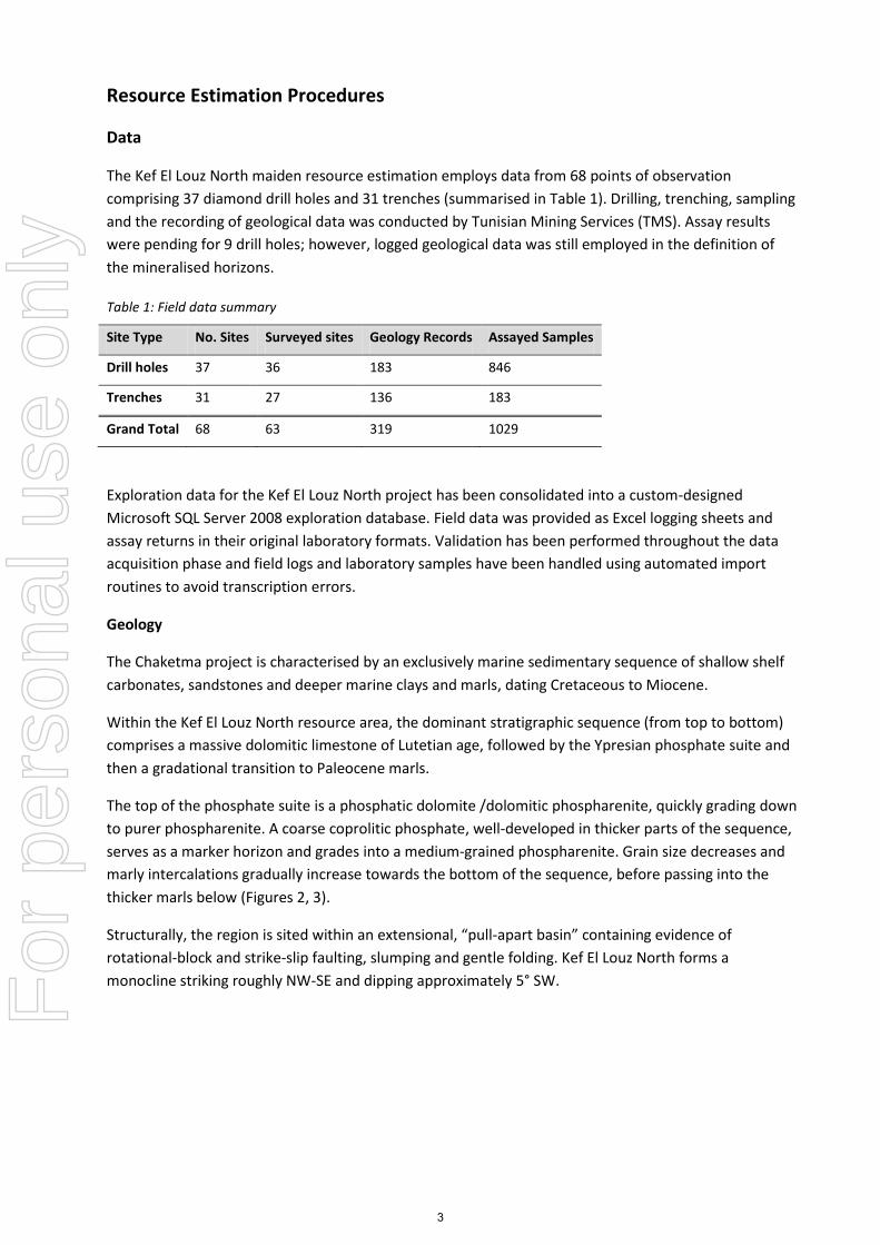
Resource Estimation Procedures
Data
The Kef El Louz North maiden resource estimation employs data from 68 points of observation
comprising 37 diamond drill holes and 31 trenches (summarised in Table 1). Drilling, trenching, sampling
and the recording of geological data was conducted by Tunisian Mining Services (TMS). Assay results
were pending for 9 drill holes; however, logged geological data was still employed in the definition of
the mineralised horizons.
Table 1: Field data summary
Site Type No. Sites Surveyed sites Geology Records Assayed Samples
Drill holes 37 36 183 846
Trenches 31 27 136 183
Grand Total 68 63 319 1029
Exploration data for the Kef El Louz North project has been consolidated into a custom-designed
Microsoft SQL Server 2008 exploration database. Field data was provided as Excel logging sheets and
assay returns in their original laboratory formats. Validation has been performed throughout the data
acquisition phase and field logs and laboratory samples have been handled using automated import
routines to avoid transcription errors.
Geology
The Chaketma project is characterised by an exclusively marine sedimentary sequence of shallow shelf
carbonates, sandstones and deeper marine clays and marls, dating Cretaceous to Miocene.
Within the Kef El Louz North resource area, the dominant stratigraphic sequence (from top to bottom)
comprises a massive dolomitic limestone of Lutetian age, followed by the Ypresian phosphate suite and
then a gradational transition to Paleocene marls.
The top of the phosphate suite is a phosphatic dolomite /dolomitic phospharenite, quickly grading down
to purer phospharenite. A coarse coprolitic phosphate, well-developed in thicker parts of the sequence,
serves as a marker horizon and grades into a medium-grained phospharenite. Grain size decreases and
marly intercalations gradually increase towards the bottom of the sequence, before passing into the
thicker marls below (Figures 2, 3).
Structurally, the region is sited within an extensional, “pull-apart basin” containing evidence of
rotational-block and strike-slip faulting, slumping and gentle folding. Kef El Louz North forms a
monocline striking roughly NW-SE and dipping approximately 5° SW.
3
For
per
sona
l use
onl
y

Drilling
Diamond drilling at Kef El Louz North occurs at a nominal spacing of 160m, although site access issues
result in irregular drill spacing over sections of the deposit. All diamond core has been geologically
logged and lithological, structural and geotechnical data recorded. To date, sample recovery has been
high and the RQD values show the local strata to be competent and well-suited to current drilling
practices. Figure 1 shows the location of the drill sites within the Kef El Louz North prospect.
Drill locations were initially located by handheld GPS and followed up with a professionally-conducted
differential GPS (DGPS) survey. One drill hole lacked DGPS survey coordinates and handheld GPS
coordinates were substituted.
No down-hole surveys have been conducted to date and drilling orientation has been discerned from
measurements directly recorded from the drill rig setup. The database contains a mixture of vertical and
angled holes between 70-75°. Core has not been oriented.
Diamond core sampling procedures stipulate a maximum 1m sample length, with an allowance to
reduce sample lengths to a minimum of 25cm, should the lithological sequence require it. As a result
the majority of drill samples consist of 1m length, HQ diameter half-core splits.
SG testing has been performed on 171 diamond core samples in the resource area using the water
displacement method. Samples were not waxed or wrapped to prevent water ingress. In situ moisture
has not yet been measured.
Figure 1: Kef El Louz North maiden resource area and points of observation employed in resource estimation.
4
For
per
sona
l use
onl
y

Trenching
Trenching is largely restricted to the north and eastern limits of the deposit (see Figure 1), where the
phosphate horizon outcrops along drainages and cliffs. Trench sites have been excavated, where
outcrop was not readily exposed and handheld diamond-blade rock saws were used to carve shallow
sample channels directly into outcrop. Trench spacing is nominally 100m between points, although this
is dictated by accessibility and the nature of the site.
Trench locations and orientations were initially located using handheld GPS and later professionally
surveyed. The DGPS surveys took multiple measurements over each trench: at the start, end and at
major inflection points, to fully define the trench orientation. At the time of resource estimation 4
trenches were without professional survey; all have been excluded from the maiden resource due to the
inability to precisely locate samples in the absence of detailed surveys.
Trench samples are processed under identical sampling protocols to drill samples and possess the
dominant 1m sample length.
Sampling
Drill and trench samples are processed by TMS personnel under a common set of procedures. The
primary field sample is jaw crushed to a 2mm pulp then riffle split to a 500g secondary sample which is
submitted for laboratory analysis.
Sample QAQC procedures are being observed, with the additional of blanks, duplicates and certified
reference standards to each sample batch. Standards and duplicates are a recent addition to the
sampling procedures, so the majority of the early batches do not contain these field QAQC measures.
Blanks have been regularly submitted from early in the program.
Laboratory Analysis
Al Amri Laboratories performed the majority of analytical work, although duplicate samples were sent
to ALS, Seville for QAQC reconciliation of the assay method. Major oxides, including the modelled
quantities (P2O5, MgO, SiO2 and CaO) were assayed using X-Ray fluorescence with borate fusion
extraction, an appropriate technique for the style and chemistry of the mineralisation.
Al Amri is recognised as operating in an ISO 9001:2000 environment and employs various quality control
procedures to ensure credibility in reported results. As part of these procedures, internal laboratory
duplicates and standards are introduced into each batch and monitored for anomalies.
Model Methodology
The primary P2O5 working section in each drill hole/trench was defined by consecutive samples
exceeding a 10%P2O5 bottom cut. Within the working section, three mineralisation domains have been
interpreted from the geological and assay data which are believed to represent fundamental changes in
the paleodepositional environment.
After statistical appraisal of the vertical grade profile, a nominal 4% MgO grade boundary was chosen to
delineate between zones. This results in upper and lower zones above the MgO threshold (Figure 2: A &
C), with a low MgO, high P2O5 layer in between (Figure 2: B)). Custom R scripting was used to partition
assayed samples into each of the 3 domains and supply intervals for wireframe development.
5
For
per
sona
l use
onl
y

Figure 2: Cross-sectional view of P2O5 block model. Horizon domain subdivision division & reconciliation of models with composites (inset). Cross section location shown on Figure 1Figure 5.
Wireframe development and block modelling was undertaken in Micromine 2011 software. Wireframes
were constrained around the periphery of mineralisation by dummy coordinates derived from local
trends in mineralisation geometry. Wireframes were clipped to topography derived from supplied 5m
contours and an outline constructed from a combination of knowledge of major bounding faults, the
distribution of points of observation and the geostatistically-derived range of mineralisation.
Samples were composited to 1m lengths. Geostatistical analysis including omnidirectional variography
onthe composited samples yielded search neighbourhood and kriging parameters for grade
interpolation of P2O5, MgO, SiO2 and CaO. These analyses revealed an approximate range of
mineralisation of 250m in each domain, which was also employed as the maximum search radius.
Figure 3: Cross-sectional view of P2O5 block model showing grade continutity between points of observation. Cross section location shown on Figure 1Figure 5.
Block models were constructed inside each of the three domain wireframes at a block size of 10mE x
10mN x 1mRL (no sub-blocking). This high block resolution was chosen to complement use of a
flattening technique, used to combat deviations in the mineralised horizon geometry. This technique
6
For
per
sona
l use
onl
y

normalised each domain’s blocks and composites to a level plane, permitting the use of a thin data
search to preserve the vertical grade profile between points of observation (Figure 3).
Figure 4: Global grade-tonnage curves (all horizons)
3-dimensional Ordinary Kriging was used to interpolate the grade of each domain in the flattened state.
The resultant grade models were reviewed on a sectional basis against the raw assays and the grade
tonnage curves inspected (see Figure 4). The extent of mineralisation was developed with consideration
of the distribution of points of observation, assumed local continuity of mineralisation and the
likelihood of any interfering local geological features.
Insufficient SG data was available to provide an interpolated value for each block, so average values
were calculated for each domain. The tonnage has been estimated on a dry basis.
Potential for Economic Development
The Kef el Louz North resource outcrops (Figure 1) and the maximum depth of the resource is less than
120m from surface, so the deposit is suitable for open cut mining. Resource thickness contours are
shown in Figure 5.
As outlined in the previously announced scoping study (14th August 2012), the planned mining method
for the Kef el Louz North resource is by conventional open cut. The scoping study assumed use of
reverse flotation to process this resource into a concentrate grading 30% P2O5. The scoping study
indicates good potential for economic extraction of this resource (note that the study assumed
additional resources would be exploited from other Chaketma prospects, and exploration and
geological modelling continue with the aim of defining additional resources). The scoping study
identified no fatal flaws to extraction, processing or ore transport.
0
5
10
15
20
25
30
-
5
10
15
20
25
30
35
40
10 11 12 13 14 15 16 17 18 19 20 21 22 23 24 25 26 27 28
Ave
rage
P2
O5
Gra
de
Ton
ne
s (M
t)
P2O5 Cutoff
Global Grade Tonnage
Tonnes P2O5 Grade
7
For
per
sona
l use
onl
y

Figure 5: Contoured cumulative thickness of all modelled phosphate horizons.
Resource Classification
The resource totals 37Mt at 21% P2O5. This is currently classified as inferred. Geos Mining anticipate
that limited additional work is required to upgrade the majority of this resource to indicated status.
This additional work includes better delineation of the unit geometry, especially of the western
boundary (from geophysical and/or additional drill data), additional analytical results including a larger
dataset of analyses with complete quality control records, and information on in situ moisture contents.
8
For
per
sona
l use
onl
y

About Celamin Holdings NL Celamin Holdings NL (ASX Code CNL) is an ASX listed company focused on the exploration and development of resource projects in North Africa initially in Tunisia and Algeria. Celamin holds the Chaketma Phosphate exploration permit in Tunisia with TMS. This project is Celamin’s current focus as it has larger target potential than Celamin’s other Phosphate project Bir El Afou. Ongoing results from channel sampling, drilling program and historic data at Chaketma have been announced. The Chaketma project would use the same rail and port infrastructure as identified in the Bir El Afou pre-feasibility studies. Celamin continues to step up work to carry out a due diligence drilling program for its farm-in to an Exploitation Permit at the Oued El Kebir precious and base metal project in Algeria. Celamin has also acquired rights to several base metal tailings Projects in Tunisia with TMS and is the holder of three Exploration Permits with base metal (Pb/Zn) targets on a 50/50 basis with TMS.
COMPETENT PERSONS STATEMENT
Information in this report that relates to Exploration Results from Chaketma is based on information compiled by
Ms Sue Border, who is a member of the Australasian Institute of Mining and Metallurgy. Ms Border is
a consultant geologist and has sufficient experience relevant to the style of mineralisation and types of deposit
under consideration and to the activities reported on to qualify as a Competent Person as defined in the 2004
Edition of the “Australian Code for Reporting of Mineral Resources and Ore Reserves. Ms Border consents to the
inclusion in this report of the matters based on information in the format and context in which it appears.
9
For
per
sona
l use
onl
y