challenges in gis researchchallenges in gis researchgood/presentations/gisruk.pdf · time is of the...
TRANSCRIPT

Challenges in GIS ResearchChallenges in GIS Research
Michael F. GoodchildUniversity of California
Santa Barbara

Thanks to…• Ordnance Survey of GB• SPLINT
– Leicester, Nottingham, UCL• Organizers

GIS research• Since 1960s• Changing agenda
– problems solved– technology advancing
social context evolving– social context evolving• What can we not yet do?
what remains to be discovered?– what remains to be discovered?– what new developments need attention?

Three topics• Spatio-temporal GIS• CyberGIS• Fundamental spatial concepts

Time is of the essence• Policy and public interest are driven by
change (Frank)E thi th t h h• Everything that happens happens somewhere in space and time (Wegener)Every major issue has a time scale• Every major issue has a time scale– climate change (decades)
climate tipping points (years)– climate tipping points (years)– economic meltdown (months)– infectious diseases (weeks)( )– disasters (days)

How to design useful tools?• The Waterfall process?
– define the application domainl it ith– sample it with use cases
– define the necessary functionality– design optimal data models– design optimal data models
• Is the domain all of spatiotemporal analysis and modeling?and modeling?– from social to environmental
• Or are there multiple domains?p– and what is driving them?


1. Tracking• Movement of features in space and time
– GPSRFID– RFID
– other technologies

Light-level geolocation (Stutchbury et al., Science 2/13/09)
Purple Martin
Wood ThrushWood Thrush
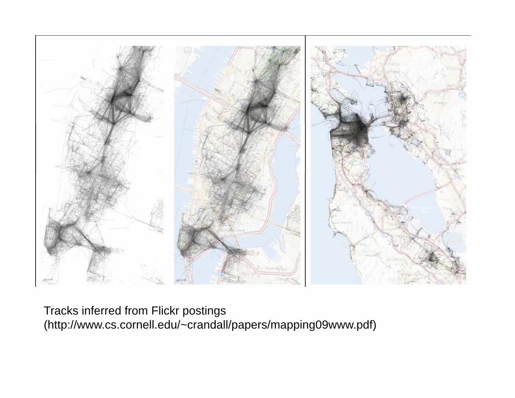
Tracks inferred from Flickr postings (http://www cs cornell edu/~crandall/papers/mapping09www pdf)(http://www.cs.cornell.edu/~crandall/papers/mapping09www.pdf)

Functionality• Hägerstrand’s conceptual framework
– new advances in theoryT k i t l ti• Track interpolation– between infrequent samples
I f b t ti it• Inferences about activity• Track convergence
Shih L Sh ’ A S i• Shih-Lung Shaw’s ArcScene extension


2. Snapshots• Barry Smith’s SNAP ontology• Time-series of remotely sensed images• Video• Change detection

Rondonia Brazil 1975 1986 1992Rondonia, Brazil, 1975, 1986, 1992


3. Polygon coverages• Reporting zones, cadaster• Gail Langran, Time in Geographic
I f ti S t 1992Information Systems, 1992• National Historic GIS
ili h i ti– reconciling change in reporting zones• z(i,t) = f[z(i,t-1),z(j,t),…]
S R ’ STARS S Ti A l i• Serge Rey’s STARS – Space-Time Analysis of Regional Systems

Comparative spatial analysis of the development of the Chinese and US economies through time, 1978-1998
Xinyue Ye, Bowling Green State University

4. Cellular automata• A fixed raster of cells• A set of states for each cell• A set of rules that determine state transitions
through time• PCRaster

Keith Clarke, UC Santa Barbara
CA model of development based on transition probabilities as functions of slope access to transportation zoning and states of neighboringof slope, access to transportation, zoning, and states of neighboring cells

5. Agent-based models• Discrete agents as geographic features• Moving, changing state• Rules governing states, behavior


6. Events and transactions• The domain of the historian
– events in space and timeli k d ti ll– linked spatially
• campaigns of armies
– hierarchically relatede a c ca y e a ed• the battle and the war• the meeting and the election
GIS t hi t i l h l hi ?– can GIS support historical scholarship?• and update the historical atlas

7. Multidimensional data• Environmental data intensively sampled in
time ith fi ed spatial s pport– with fixed spatial support
– NetCDF

One domain or seven?• All seven need the multidisciplinary tools of
GISto interpret assess and is ali e res lts– to interpret, assess, and visualize results
– to package results for public consumption• Are there more (or fewer)?• Are there more (or fewer)?

Tasks for the research community• What are the research questions?
– what are the use cases?d i d i b d t il bilit– some domains are driven by data availability
rather than science questions• What are the functions?What are the functions?
– at what level of granularity?– standardized for discoveryy– elusive even for traditional GIS
• What are the data models?– the focus of much of the research to date

CyberGIS• GIS as a distributed enterprise
– server-based GISS i i t d hit t• Service-oriented architecture
• Fully interoperable

Progress to date• Interoperable location referencing
– coordinate transformationsdi dd– geocoding addresses
– point-of-interest databases
34 deg 24 min 42.7 seconds north, 119 deg 52 min 14.4 sec west
236150m east, 3811560m north, UTM Zone 11 Northern Hemisphere
US National Grid reference 11SKU36151156909 West Campus Lane, Goleta, CA 93117, USAMike Goodchild’s house
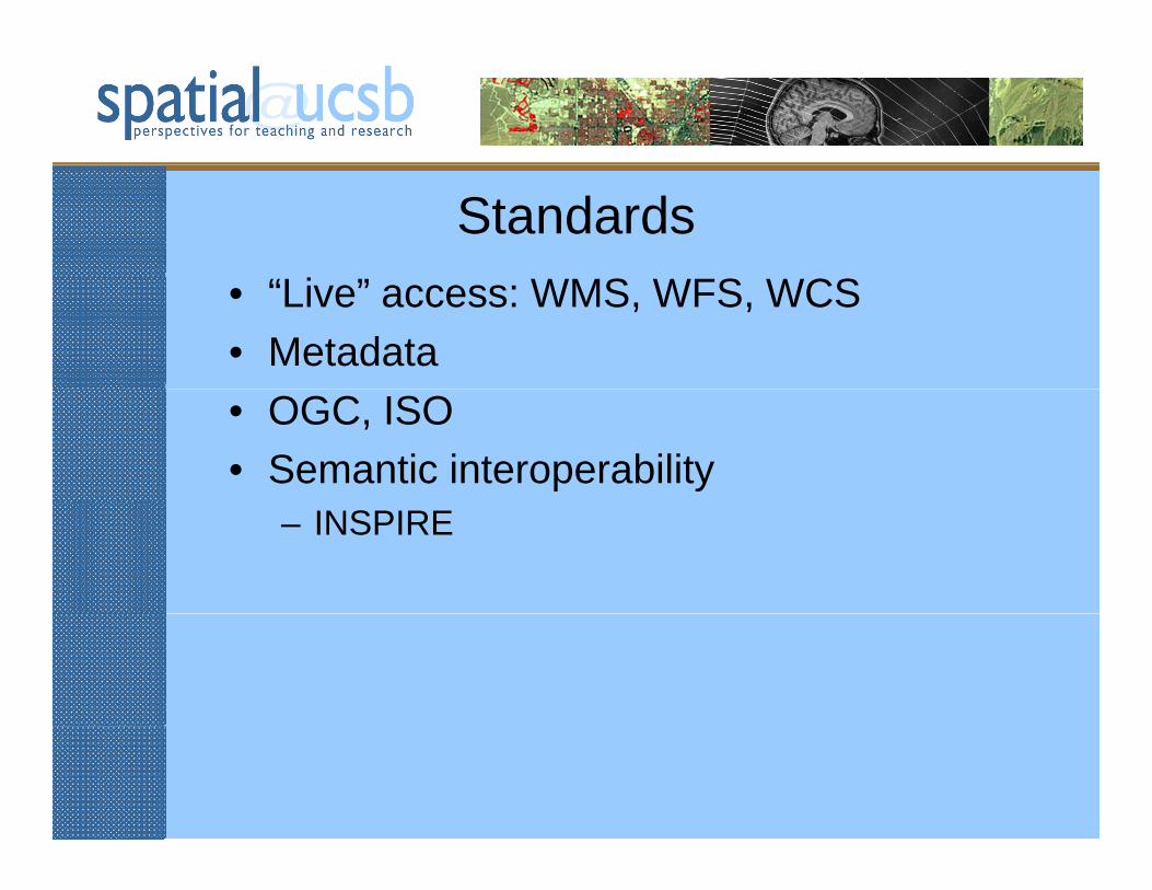
Standards• “Live” access: WMS, WFS, WCS• Metadata• OGC, ISO• Semantic interoperability
– INSPIRE

Engagement• Citizens as both producers and consumers
– enabled by standards, GPS, cartographic softwaresoftware
– neogeography• OpenStreetMap and HaitiOpenStreetMap and Haiti

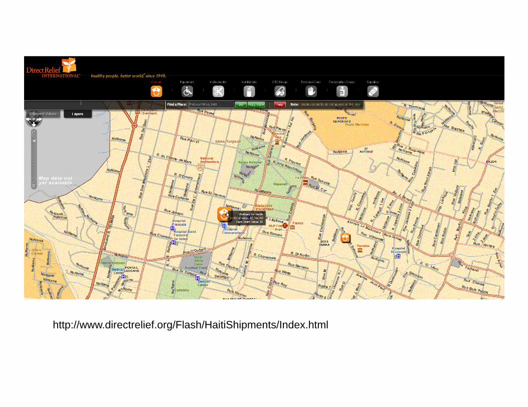
http://www.directrelief.org/Flash/HaitiShipments/Index.html

So why the fuss?• Why cyber geographic information system?
– why not cyber geriatric information system?T i t• Two points– represent impediments
call for fundamental research– call for fundamental research

Location as common key• The stack of layers

But in reality…• Spatial databases are organized as layers
– horizontal integration not “vertical”t b t ll l– property z about all places
– rather than all properties about location x• “tell me everything about location x”tell me everything about location x
– overlay must be invoked explicitly• graphical overlay or topological overlay
– many mashups are merely graphical overlay• a visual spatial join


The spatial join• Using location as a common key to link
tablesAll l ti f bj t t• All location references are subject to uncertainty
measurement error– measurement error– vagueness in feature identification– indeterminate limitsindeterminate limits
• The probabilistic join
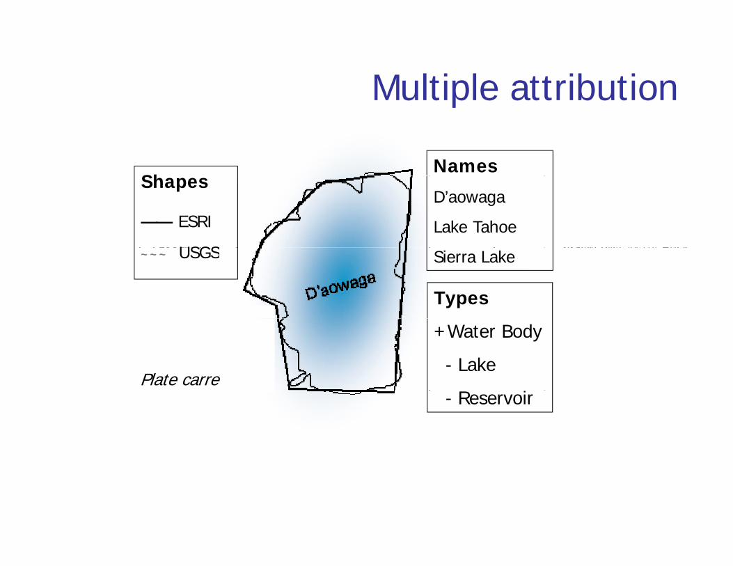
Multiple attributionp
ShNames
Shapes
—— ESRI
USGS
D’aowaga
Lake Tahoe~~~ USGS Sierra Lake
Types
Plate carre
+Water Body
- Lake
- Reservoir

The true spatial join is still elusive• Much better techniques needed
– especially to deal with vague, vernacular referencesreferences
– in text, speech, human discourse generally– beyond formally defined coordinatesbeyo d o a y de ed coo d a es– well-defined metrics of confidence
• We are a long way from realizing the fully g y g yinteroperable vision

The functionality of cyberGIS• CyberGIS requires a formally defined
functionalityWh t i th i t l l f l it f• What is the appropriate level of granularity of cyberGIS functions?How many functions are there?• How many functions are there?– 542 in the ArcGIS 9.3.1 toolbox
• How to navigate among them?• How to navigate among them?– 18 top-level categories
• vaguely defined, overlappingvaguely defined, overlapping
– “Analysis”, “Spatial Analyst”, “Spatial Statistics”, “Geostatistical Analyst”

Requirements• A standard set of functions
– interoperable across all serversd fi d l it– defined granularity
• an atomic level
– in reality functionality is determined in part by ea y u c o a y s de e ed pa bylegacy
• and non-interoperable
hidd f th h i t– hidden from the user where appropriate

What is this really about?• It used to be difficult to do
– senior undergraduate coursesth GIS f i l– the GIS professional
• In a world of Google Earth what does everyone need to know?everyone need to know?– is spatial really special?– do we SAPs think differently?do we SAPs think differently?

“1. Linguistic Children with this kind of intelligence enjoy writing, reading, telling stories or doing crossword puzzles. p
2. Logical-Mathematical Children with lots of logical intelligence are interested in patterns, categories and relationships. They are drawn to arithmetic problems, strategy games and experiments.
3. Bodily-Kinesthetic yThese kids process knowledge through bodily sensations. They are often athletic, dancers or good at crafts such as sewing or woodworking.
4. Spatial These children think in images and pictures. They may be fascinated with mazes or g p y yjigsaw puzzles, or spend free time drawing, building with Lego or daydreaming.
5. Musical Musical children are always singing or drumming to themselves. They are usually quite aware of sounds others may miss. These kids are often discriminating listeners. y g
6. Interpersonal Children who are leaders among their peers, who are good at communicating and who seem to understand others' feelings and motives possess interpersonal intelligence.
7. Intrapersonal pThese children may be shy. They are very aware of their own feelings and are self-motivated.”
Howard Gardner
http://www.professorlamp.com/ed/TAG/7_Intelligences.html

What is spatial thinking?“Three aspects of spatial ability:• Spatial knowledge
– symmetry, orientation, scale, distance decay,symmetry, orientation, scale, distance decay, etc.
• Spatial ways of thinking and acting– using diagramming or graphing, recognizing
tt i d t h fpatterns in data, change over space from change over time, etc.
• Spatial capabilities– ability to use tools and technologies such as– ability to use tools and technologies such as
spreadsheet, graphical, statistical, and GIS software to analyze spatial data”
http://www.nap.edu/catalog/11019.html

Fundamental spatial concepts• Some acquired in early childhood
– distance, directionS i d l i hi h d ti• Some acquired only in higher education– spatial dependence, spatial heterogeneity
not intuitive– not intuitive– can be taught– serve to distinguish the SAPserve to distinguish the SAP


Karl Grossner
www.teachspatial.org


186 concepts• Overarching structures
– alphabetical sortt h l l ti hi– part-whole relationships
– synonyms– domain-specific meanings– domain-specific meanings– mapping to GIS functions– level of conceptual complexityp p y– mapping to curriculum standards
Concluding comments• Much still to be done• Advancing technology creates a constant
l f i t ti tisupply of interesting questions• Need for future vision
h t ill ti ll bl d ld l k lik i– what will a geospatially enabled world look like in 2020? or 2015?
– how will society cope?how will society cope?