change detection in satellite images using reconstruction
TRANSCRIPT

HAL Id: hal-02559342https://hal.archives-ouvertes.fr/hal-02559342
Submitted on 30 Apr 2020
HAL is a multi-disciplinary open accessarchive for the deposit and dissemination of sci-entific research documents, whether they are pub-lished or not. The documents may come fromteaching and research institutions in France orabroad, or from public or private research centers.
L’archive ouverte pluridisciplinaire HAL, estdestinée au dépôt et à la diffusion de documentsscientifiques de niveau recherche, publiés ou non,émanant des établissements d’enseignement et derecherche français ou étrangers, des laboratoirespublics ou privés.
Change Detection in Satellite Images usingReconstruction Errors of Joint Autoencoders
Ekaterina Kalinicheva, Jeremie Sublime, Maria Trocan
To cite this version:Ekaterina Kalinicheva, Jeremie Sublime, Maria Trocan. Change Detection in Satellite Images usingReconstruction Errors of Joint Autoencoders. Artificial Neural Networks and Machine Learning –ICANN 2019: Image Processing, pp.637-648, 2019, �10.1007/978-3-030-30508-6_50�. �hal-02559342�
Change Detection in Satellite Images usingReconstruction Errors of Joint Autoencoders
Ekaterina Kalinicheva1, Jeremie Sublime1,2, and Maria Trocan1
1 LISITE - DASSIP TeamISEP, 10 rue de Vanves, 92130 Issy-Les-Moulineaux, France
[email protected] LIPN - CNRS UMR 7030
99 av. J-B Clement, 93430 Villetaneuse, [email protected]
Abstract. With the growing number of open source satellite image timeseries, such as SPOT or Sentinel-2, the number of potential change de-tection applications is increasing every year. However, due to the imagequality and resolution, the change detection process is a challenge nowa-days. In this work, we propose an approach that uses the reconstructionlosses of joint autoencoders to detect non-trivial changes (permanentchanges and seasonal changes that do not follow common tendency) be-tween two co-registered images in a satellite image time series. The au-toencoder aims to learn a transformation model that reconstructs oneco-registered image from another. Since trivial changes such as changesin luminosity or seasonal changes between two dates have a tendency torepeat in different areas of the image, their transformation model can beeasily learned. However, non-trivial changes tend to be unique and cannot be correctly translated from one date to another, hence an elevatedreconstruction error where there is change. In this work, we compare twomodels in order to find the most performing one. The proposed approachis completely unsupervised and gives promising results for an open sourcetime series when compared with other concurrent methods.
Keywords: satellite images · change detection · autoencoder · unsuper-vised learning · reconstruction loss.
1 Introduction
Nowadays, change detection in satellite image time series (SITS) is required formany different applications. Among them, there are numerous ecological appli-cations such as the analysis and preservation of the stability of ecosystems or thedetection and the analysis of phenomena such as deforestation and droughts, thestudies of economical development of cities, the analysis of vegetation state fordifferent agricultural purposes, etc. While in some applications, we are interestedin seasonal changes such as evolutions in agricultural parcels, others require thedetection of the permanent changes such as buildings or roads constructions.Nevertheless, due to image resolution and preprocessing level (most of the SITS

2 E. Kalinicheva et al.
do not have a correction of the atmospheric factors), properly detecting changesremains a difficult task.
Different algorithms for change detection are proposed in the literature. Forexample, in [5] the authors use PCA and hybrid classification methods for changedetection in urban areas. The authors of [2] propose siamese neural networks forsupervised change detection in open source multispectral images.
However, most change detection algorithms are supervised or semi-supervised,and therefore need some labeled data. Providing the labeled data for remote sens-ing images and especially SITS is a costly and time-consuming task due to thevariance of objects present in them and the time needed to produce the largeamount of labeled images required to train large models.
This lack of labeled data and the difficulty to acquire them is not specificto SITS and remains true for any application with satellite images. This issuehas encouraged the use of unsupervised methods to tackle this type of imagesespecially, when the number of features is large or when the images are verycomplex [12].
In this paper, we propose an unsupervised approach based on a neural net-work autoencoder (AE) algorithm for non-trivial change detection in SITS. Thealgorithm is based on change detection between two bi-temporal images Imn
and Imn+1. Needless to say, it can be also applied to two co-registered imagesinstead of a SITS. In the presented approach, we use joint AEs to create mod-els able to reconstruct Imn+1 from Imn and vice versa by learning the imagefeatures. Obviously, the non-changed areas and trivial changes such as seasonalones will be easily learned by the model, and therefore reconstructed with smallerrors. As the non-trivial changes are unique, they will be considered as outliersby the model, and thus will have a high reconstruction error (RE). Thresholdingon the RE values allows us to create a binary change map (CM). The proposedmethod has showed promising results on a dataset with high ratio of agriculturalareas and outperformed the concurrent approach. Different joint AE models weretested in order to find the most accurate. Our method has a low complexity andgives high quality results on open source high resolution (HR) images.
The remainder of this article is organized as follows: In section 2, we presentrelated works. Section 3 details our proposed approach. Section 4 is dedicatedto experimental results and some conclusions and future work perspectives aredrawn in section 5.
2 Related works
The main difficulty with unsupervised approaches to analyze satellite images isthat they usually produce lower quality results than supervised ones. To improvethe quality of unsupervised change detection between two images, the fusionof results from different algorithms is often proposed [6]. At the same time,automatic methods for selection of changed and unchanged pixels are used toobtain training samples for a multiple classifier system [13]. Following this paper,the authors of [1] propose the improved backpropagation method of a deep belief
Change Detection using Reconstruction Errors of Joint AEs 3
network (DBN) for change detection based on automatically selected changelabels.
Nevertheless, classic feature comparison approaches do not separate trivial(seasonal) changes from non-trivial ones (permanent changes and changes thatdo not follow seasonal tendency). This weakness can drastically complicate theinterpretation of change detection results for regions with high ratio of vegetationareas. In fact, when analyzing two images belonging to different seasons of theyear, almost all the area will be marked as change and further analysis will beneeded to identify meaningful changes (non-trivial).
In [10], a regularized iteratively reweighted multivariate alteration detec-tion (MAD) method for the detection of non-trivial changes was proposed. Thismethod is based on linear transformations between different bands of hyper-spectral satellite images and canonical correlation analysis. However, spectraltransformation between multi-temporal bands is very complex. For these rea-sons, deep learning algorithms which are known to be able to model non-lineartransformations have proved their efficiency to solve this problem [14].
Our method is based on the approach proposed in [14]. In this work, theauthors use a Restricted-Boltzmann Machines-based (RBM) model to learn thetransformation model for a couple of very high resolution (VHR) co-registeredimages Im1 and Im2. RBM is a type of stochastic artificial network that learnsthe distribution of the binary input data. When dealing with the continuousdata, Gaussian-Bernoulli RBM (GBRBM) is used [9].
The principle of the proposed method to detect changes is the following:most of the trivial changes can be easily modeled from Im1 to Im2, at thesame time, non-trivial changes will not be properly reconstructed. Therefore,the reconstruction accuracy can be used to detect the non-trivial change areas.
The proposed approach consist of the following steps: feature learning, fea-ture comparison and thresholding. During the feature learning step, the algo-rithm learns some meaningful features to perform transformation of patches ofIm1 to the patches of Im2. Once the features are learned by the model, Im1
is transformed in Im′2. Then the difference image (DI) of Im2 and Im′2 is cal-culated. The same steps are performed to create a DI of Im1 and Im′1. Thethresholding is then applied on an average DI. Obviously, the areas with highdifference values will be the change areas.
For the feature learning, the authors use an AE model composed of stackedRBMs layers GBRBM1-RBM1-RBM2-GBRBM2. The authors indicate that thealgorithm is sensitive to changing luminosity and has high level of false positivechanges in real change data. To our knowledge, the algorithm was tested onlyon urban areas.
3 Proposed approach
Our method is similar with the one presented in [14] that we have introducedin the previous section. However, contrary to RBM models that are based on astochastic approach and distribution learning, we propose to use a deterministic

4 E. Kalinicheva et al.
model based on feature extraction. Furthermore, we use patch reconstructionerror for every pixel of the image - instead of image difference - as extractingfeatures from every pixel neighborhood is an important step for any eventualsubsequent pixel-wise classification task.
Classical AEs are a type of neural network where the input is the same asthe output. During the learning process, the encoding pass of the model learnsome meaningful representation of the initial data that is being transformedback during the decoding pass. In our work, we test two deterministic AE archi-tectures and assess their performance for change detection in order to pick thebest adapted one. The tested models are joint fully-convolutional AEs and jointconvolutional AEs.
Fully-convolutional AEs consist of a stack of layers that apply different con-volutions (filters) to the input data in order to extract meaningful feature maps(FM) (Figure 1). Convolutions are often used in image processing as they dealwith non-flattened data (2D and 3D). Therefore, unsupervised feature extractionwith fully-convolutional AEs has been proved efficient in different remote sens-ing applications [4]. Convolutional AEs equally contain different convolutionallayers that are followed by some fully-connected layers to compress the featuremaps. Usually these AEs are used for image clustering as FC layers perform thedimensionality reduction [8].
Fig. 1. Fully-convolutional AE model. Pre-training phase.
3.1 Change detection algorithm
Let Im1, Im2, ...., ImS−1, ImS be a SITS made of S co-registered imagestaken at dates T1, T2, ... , TS−1, TS . Our algorithm steps are the followings, seeFigure 2:
– The preprocessing step consists of a relative radiometrical normalization [7].It reduces a number of potential false and missed change alarms related tothe changing luminosity of objects.
– The first step of change detection algorithm consist in model pre-training onthe whole dataset (Figure 2).
– During the second step, we fine-tune the joint AE model for every coupleof images (Imn, Imn+1). Once the model is trained, we calculate the re-construction error of Im′n+1 from Imn and vise versa for every patch of theimages. In other words, the reconstruction error of every patch is associatedto the position of its central pixel on the image.

Change Detection using Reconstruction Errors of Joint AEs 5
Fig. 2. Change detection algorithm.
– In the last step, we identify areas of high reconstruction error using Otsu’sthresholding method [11] in order to create a binary change map CMn,n+1
with non-trivial change areas.
3.2 Model pre-training and fine-tuning
In our method, we use deep AEs to reconstruct Imi+1 from Imi. During themodel pre-training, the feature learning is performed patch-wise for a sampleextracted from the SITS. In our method, we sample H×W
S patches (H and Wrepresent image height and width, respectively) from every image to preventthe model from overfitting. The patches for the border pixels are generated bymirroring the existing ones in the neighborhood. During the encoding pass, themodel extracts feature maps (FM) for the fully-convolutional AE (and featurevector for the convolutional AE) of i, j,m-patch of chosen samples, and thenduring the decoding pass, it reconstructs them back to the initial i, j,m-patch(i ∈ [1, H], j ∈ [1,W ], m ∈ [1, S]).
The fine-tuning part consists of learning two joint reconstruction models AE1
and AE2 for every patch of a couple of co-registered images (Imn, Imn+1). Thepatches are extracted, for every pixel of the images (H×W patches in total) asthe local neighborhood wherein the processed pixel is the central one (i.e., theimage i, j-pixel corresponds to i, j-patch central pixel).
Our joint fully-convolutional AEs model is presented in Figure 2). The jointmodel for the convolutional AE has the same structure. AE1 and AE2 have thesame configuration of layers as the pre-trained model, and are initialized withthe parameters it learned. In the joint model, AE1 aims to reconstruct patches ofIm′n+1 from patches of Imn and AE2 reconstructs Im′n from Imn+1. The wholemodel is trained to minimize the difference between: the decoded output of AE1and Imn+1, the decoded output of AE2 and Imn, and the encoded outputs ofAE1 and AE2.
6 E. Kalinicheva et al.
In our work, we use the mean squared error (MSE) for model optimizationand calculation of the patch reconstruction error.
Once the model is trained and stabilized, we perform the image reconstruc-tion of Im′n and Im′n+1 for every patch, and we create two images representingtheir reconstruction errors. We apply Otsu’s thresholding [11] to the averagereconstruction error of these images in order to produce a binary change map.
4 Experimental results
4.1 Dataset
Our algorithm was applied to a SPOT-5 SITS of Montpellier area, France, takenbetween 2002 and 2008. This SITS belongs to the archive Spot World Heritage3.This particular SITS was chosen due to its high ratio of agricultural zones andprogressive construction of new areas. The preprocessing level of SITS is 1C (or-thorectified images, reflectance of the top of atmosphere). We kept only green,red and NIR bands that have 10 meters resolution as they are the most perti-nent. The original images are clipped to rectangular shapes of 1600×1700 pixels,radiometrically normalized and transformed to UTM zone 31N: EPSG Projec-tion (transformation from geographic coordinate system in degree coordinatesto a projected coordinate system in meter coordinates).
4.2 Results
As mentioned in section 3, we propose different architectures: convolutional andjoint fully-convolutional AEs, and we compare them in order to assess theirstrengths and weaknesses. We further compare our approaches with the RBM-based method presented in [14] that we have discussed in section 2 and withimproved RBM method. Initially, in [14] the images are clipped in H×W
p×p notoverlapped patches. In the improved method, we propose to extract patcheswith neighborhoods of every pixel of the image (H×W patches). Equally, weuse the patch reconstruction error instead of the image difference to detect thechanges. In other words, the improved RBM method uses the same steps as inour proposed algorithms.
In the experiments, we use the architectures presented in Table 1, where B isthe number of spectral bands and p is the patch size (in these reported results,the patch size is 5×5 for all our methods, the patch size is justified later in text).The following parameters were chosen for all convolutional layers: kernel size=3,stride=1, padding=1. Adam algorithm was used to optimize the models. Duringthe pre-training phase, the learning rate was set to 0.0005 and then changed to0.00005 for the fine-tuning phase.
The RBM model presented in [14] is developed for VHR images, but we havekept the patch size 10×10 pixels and the layer sizes suggested by the authors.In the improved RBM method we use 5×5 pixels patch size as in our methods.
3 Available on www.theia-landsat.cnes.fr

Change Detection using Reconstruction Errors of Joint AEs 7
Table 1. Models architecture.
F-conv.AE Conv.AE RBM Impr. RBMen
coder
C(B,32)+RC(B,32)+R C(32,32)+R GBRBM(p2×B,C(32,32)+R C(32,64)+R GBRBM(p2×B,384)+S (p + 1)2×B)+SC(32,64)+R C(64,64)+R RBM(384,150)+S RBM((p + 1)2×B,C(64,64)+`2 L(64×p2, 12×p2)+R (p− 2)2×B)+S
L(12×p2, 2×p2)+`2
dec
oder
L(2×p2, 12×p2)+R
C(64,64)+R L(12×p2, 64×p2)+R RBM((p− 2)2×B,C(64,32)+R C(64,64)+R RBM(150,384)+S (p + 1)2×B)+sC(32,32)+R C(64,32)+R GBRBM(384,p2×B)+S GBRBM((p + 1)2×B,C(32,B)+S C(32,32)+R p2×B)+S
C(32,B)+S
C- Convolutional, L- Linear, R- ReLU, S- Sigmoid, `2- `2-norm
We apply ReLU and sigmoid activation functions as well as `2-normalization tothe different layers outputs.In our approaches and in improved RBM method, before learning the Otsu’sthreshold, we exclude 0.5% of the highest values under the hypothesis that theycorrespond to some noise and extreme outliers.
We assess the algorithms performances on two extracts from the SPOT-5SITS. The image couples were taken between May 2004 and April 2005 for thefirst extract, and between February 2006 and August 2008 for the second one. Toevaluate the proposed approaches, we compare the obtained results with groundtruth change maps. These ground truths were created for an extract of the imageof size 800×600 pixels (48 km2) for the first couple and for 320×270 pixels (8,64km2) for the second one. However, the change detection was performed on thefull images of 1600×1700 pixels (272 km2).
The following quality criteria were used to evaluate the performances of thedifferent approaches: precision (1), recall (2) and Cohen’s kappa score [3].
Precision =TruePositives
TruePositives + FalsePositives(1)
Recall =TruePositives
TruePositives + FalseNegatives(2)
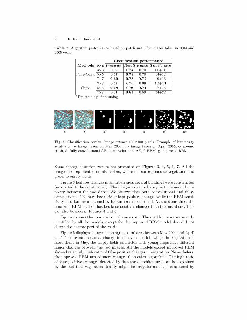
The patch size of 5×5 pixels was chosen empirically, however, the correlationbetween the patch size and the performance of our algorithms is shown in Table 2.We can observe that p = 3 gives us poor results for both methods as the patch donot contain enough information about the neighborhood, p = 7 gives us slightlybetter results for fully-convolutional AE than p = 5 though learning time ishigher. However, we see that for p = 5 performance of convolutional AE is muchbetter than for p = 7. It can be explained by layer flattening when passing fromconvolutional layers to linear.
8 E. Kalinicheva et al.
Table 2. Algorithm performance based on patch size p for images taken in 2004 and2005 years.
Classification performanceMethods p×p Precision Recall Kappa Timea, min
Fully-Conv.3×3 0.69 0.73 0.70 11+105×5 0.67 0.78 0.70 14+127×7 0.69 0.78 0.72 19+16
Conv.3×3 0.67 0.74 0.69 12+115×5 0.68 0.79 0.71 17+167×7 0.61 0.81 0.69 24+22
aPre-training+fine-tuning.
Fig. 3. Classification results. Image extract 100×100 pixels. Example of luminositysensitivity. a- image taken on May 2004, b - image taken on April 2005, c- groundtruth, d- fully-convolutional AE, e- convolutional AE, f- RBM, g- improved RBM.
Some change detection results are presented on Figures 3, 4, 5, 6, 7. All theimages are represented in false colors, where red corresponds to vegetation andgreen to empty fields.
Figure 3 features changes in an urban area: several buildings were constructed(or started to be constructed). The images extracts have great change in lumi-nosity between the two dates. We observe that both convolutional and fully-convolutional AEs have low ratio of false positive changes while the RBM sensi-tivity in urban area claimed by its authors is confirmed. At the same time, theimproved RBM method has less false positives changes than the initial one. Thiscan also be seen in Figures 4 and 6.
Figure 4 shows the construction of a new road. The road limits were correctlyidentified by all the models, except for the improved RBM model that did notdetect the narrow part of the road.
Figure 5 displays changes in an agricultural area between May 2004 and April2005. The overall seasonal change tendency is the following: the vegetation ismore dense in May, the empty fields and fields with young crops have differentminor changes between the two images. All the models except improved RBMshowed relatively high ratio of false positive changes in vegetation. Nevertheless,the improved RBM missed more changes than other algorithms. The high ratioof false positives changes detected by first three architectures can be explainedby the fact that vegetation density might be irregular and it is considered by

Change Detection using Reconstruction Errors of Joint AEs 9
Fig. 4. Classification results. Image extract 180×190 pixels. a- image taken on May2004, b - image taken on April 2005, c- ground truth, d- fully-convolutional AE, e-convolutional AE, f- RBM, g- improved RBM.
Fig. 5. Classification results. Image extract 230×200 pixels. a- image taken on May2004, b - image taken on April 2005, c- ground truth, d- fully-convolutional AE, e-convolutional AE, f- RBM, g- improved RBM.

10 E. Kalinicheva et al.
Fig. 6. Classification results. Image extract 320×270 pixels. a- image taken on February2006, b - image taken on August 2008, c- ground truth, d- fully-convolutional AE, e-convolutional AE, f- RBM, g- improved RBM.
the algorithm as changes. We observe that convolutional AE have slightly betterresults than other models.
Figure 6 represents changes in an agricultural area between February 2006and August 2008 as well as some constructions. The overall seasonal change ten-dency is the following: the fields that are empty in February have vegetation inAugust, and vise versa. Forest’s vegetation state (bottom right corner) has someminor changes. We can see again that the convolutional AE has slightly bet-ter results than the fully-convolutional AE. However, the ratio of false positivechanges is elevated. Moreover, in most cases, only a part of a field is incorrectlylabeled as change. As in the previous example, it can be explained by irregularvegetation density, and further morphological analysis might be needed to obtainbetter results. At the same time, the initial RBM model showed better perfor-mance for the detection of a linear object that corresponds to constructions atthe roadside at the lower left part of the image, though the level of false positivechanges is high both in urban and agricultural areas.
Figure 7 shows the limitations of the proposed approach for the detectionof the construction of a tramway line. Our method have poor quality of changedetection for linear objects that can be explained by the patch-wise learning.As a patch reconstruction error determines the change class of its central pixel,changes in 1-2 pixel width linear objects can not be properly detected.
The different approaches performances are presented in Table 3. The algo-rithms were tested on NVIDIA Titan X GPU with 12 GB of RAM. Based onthe presented results and on the performance estimators, we can conclude thatjoint convolutional AEs slightly outperformed fully-convolutional ones, thoughthe training time stays higher as the model is more complicated. The perfor-

Change Detection using Reconstruction Errors of Joint AEs 11
Fig. 7. Classification results. Algorithm limitations. Image extract 300×280 pixels. a-image taken on May 2004, b- image taken on April 2005, c- ground truth, d- convolu-tional AE.
Table 3. Performance of change detection algorithms on SPOT-5 images.
Classification performanceMethods Precision Recall Kappa Timea, min
2004
2005
RBM AE 0.48 0.64 0.52 8+2Impr. RBM AE 0.52 0.63 0.54 20+10
Conv. AE 0.68 0.79 0.71 17+16Fully-Conv. AE 0.67 0.78 0.70 14+13
2006
2008
RBM AE 0.40 0.61 0.43 8+2Impr. RBM AE 0.50 0.54 0.48 20+10
Conv. AE 0.76 0.79 0.75 17+16Fully-Conv. AE 0.80 0.71 0.73 14+12
aPre-training+fine-tuning.
mance of joint convolutional AEs can be explained by the higher complexityof the convolutional model. At the same time, both models of our approachshowed better performances for change detection than the RBM-based models.However, it can be noted that the initial RBM method still has a high recall andthe best training time despite a high level of false positive changes in urban areascompared to our approaches. We can equally conclude that methods with pixel-wise extracted patches have higher performance than initial RBM method wherepatches are not overlapped. Nevertheless, the improved RBM method detectedless changes than the initial RBM method, though the number of false positiveschanges is much lower and overall classification performance characterized bykappa is higher.
5 Conclusion
In this paper, we have presented unsupervised deterministic approaches forchange detection in open source SITS based on AE models. Our experimentshave shown that our deterministic AE models perform better than state of the artRBM approaches on a large area with various land cover occupation. Among our
12 E. Kalinicheva et al.
proposed architectures, the joint fully-convolutional AEs model showed slightlybetter performances in spite of a longer training time.
In future works, we will focus on developing an algorithm for clustering thesechanges. Furthermore, we will improve our model by adding the analysis ofmorphological features, leading to more robust results for images with highervariance of seasonal changes.
References
1. Cao, G., Wang, B., Xavier, H., Yang, D., Southworth, J.: A new difference imagecreation method based on deep neural networks for change detection in remote-sensing images. International Journal of Remote Sensing 38(23), 7161–7175 (2017)
2. Caye Daudt, R., Le Saux, B., Boulch, A., Gousseau, Y.: Urban change detectionfor multispectral earth observation using convolutional neural networks. CoRRabs/1810.08468 (2018)
3. Cohen, J.: A coefficient of agreement for nominal scales. Educational and Psycho-logical Measurement 20(1), 37–46 (1960)
4. Cui, W., Zhou, Q.: Application of a hybrid model based on a convolutional auto-encoder and convolutional neural network in object-oriented remote sensing clas-sification. Algorithms 11, 9 (01 2018)
5. Deng, J.S., Wang, K., Deng, Y.H., Qi, G.J.: PCAbased landuse change detec-tion and analysis using multitemporal and multisensor satellite data. InternationalJournal of Remote Sensing 29(16), 4823–4838 (2008)
6. Du, P., Liu, S., Gamba, P., Tan, K., Xia, J.: Fusion of difference images for changedetection over urban areas. IEEE Journal of Selected Topics in Applied EarthObservations and Remote Sensing 5(4), 1076–1086 (Aug 2012)
7. El Hajj, M., Begue, A., Lafrance, B., Hagolle, O., Dedieu, G., Rumeau, M.: Rela-tive radiometric normalization and atmospheric correction of a spot 5 time series.Sensors 8(4), 2774–2791 (2008)
8. Guo, X., Liu, X., Zhu, E., Yin, J.: Deep clustering with convolutional autoencoders.In: Liu, D., Xie, S., Li, Y., Zhao, D., El-Alfy, E.S.M. (eds.) Neural InformationProcessing. pp. 373–382. Springer International Publishing, Cham (2017)
9. Hinton, G.E., Salakhutdinov, R.R.: Reducing the dimensionality of data with neu-ral networks. Science 313(5786), 504–507 (2006)
10. Nielsen, A.A.: The regularized iteratively reweighted MAD method for changedetection in multi- and hyperspectral data. IEEE Transactions on Image Processing16(2), 463–478 (Feb 2007)
11. Otsu, N.: A threshold selection method from gray-level histograms. IEEE Trans-actions on Systems, Man, and Cybernetics 9(1), 62–66 (Jan 1979)
12. Sublime, J., Troya-Galvis, A., Puissant, A.: Multi-scale analysis of very high reso-lution satellite images using unsupervised techniques. Remote Sensing 9(5), 495(2017)
13. Tan, K., Jin, X., Plaza, A., Wang, X., Xiao, L., Du, P.: Automatic change detec-tion in high-resolution remote sensing images by using a multiple classifier systemand spectralspatial features. IEEE Journal of Selected Topics in Applied EarthObservations and Remote Sensing 9(8), 3439–3451 (Aug 2016)
14. Xu, Y., Xiang, S., Huo, C., Pan, C.: Change detection based on auto-encoder modelfor vhr images. Proc SPIE 8919, 02– (10 2013)