chapter 1 – central riverside area - ucl - … · draft chapter 1 – central riverside area ....
TRANSCRIPT

DRAFT CHAPTER 1 – CENTRAL RIVERSIDE AREA
The riverside between the former naval dockyard and the Arsenal stretching
back to the High Street is where settlement began more than 2,000 years ago,
on firm and fertile Thanet-sand beds along the edge of the Thames and
between expanses of marshland. Here was the Iron Age fort or oppidum. On a
spur of higher ground immediately to the south-west perched the medieval
parish church. Its successor of the 1730s is slightly further inland – a retreat
from erosion, yet still prominent. Below, where the early town stood, antiquity
is absent and even remnants of the area’s eighteenth- and nineteenth-century
faces are scarce. Old Woolwich has been blasted. This is partly because
industry has been a major presence, and at a large scale, since at least the
sixteenth century. A single wharf, just east of Bell Water Gate and lately a car
park, saw the origins of both the naval dockyard and the Arsenal in the
sixteenth and seventeenth centuries before the establishments moved,
respectively, west and east. The area’s houses were largely humble, so subject
to frequent renewal. Industry and housing have given way to commerce and
public amenities, including a park. It is symptomatic of a churning history that
in 2012 about half the ground covered in this chapter is subject to
development schemes. Housing is scheduled to make a comeback.
Woolwich High Street is the spine of the chapter, and yet it is curiously absent
– so little of substance stands upon it. The High Street may have had Roman
origins as part of a route linking riverside settlements. But of its pre-Georgian
buildings, let alone the Roman, virtually nothing is known, and its north side
has entirely lost the character of a high street. What there is to say about
medieval and earlier Woolwich is mostly presented in the Introduction. This
chapter starts with an account of the area’s industry and institutions from the
sixteenth century to the end of the Georgian period, principally the first
dockyard and gun wharf and England’s first state ropeyard, with the
eighteenth-century parish church of St Mary Magdalene set in place after a
Survey of London © English Heritage 2012 1
DRAFT preliminary description of its medieval predecessor. The rest of the ground is
then divided to look first at the riverside lands north of the High Street, taking
in some old houses, chapels and pubs, and then industrial and other
developments since 1800, including the notorious slum that was known as the
Dusthole, as well as the Woolwich Free Ferry and Foot Tunnel. The history
then crosses the High Street, on the south side of which there are some modest
survivals from the eighteenth century, as well as two spectacular cinemas of
the 1930s where the west end of Powis Street meets Parson’s Hill. Finally,
attention returns to the site of the ropeyard, replaced in the 1830s with
Beresford Street, where there has been a peculiar mix of buildings. Notable
among these are three that have gone – Holy Trinity Church, the Empire
Theatre and the Autostacker.
Early industry and institutions
The military-industrial sites that preceded and stood between the naval
dockyard and the Arsenal have received little attention, though lands here were
in state use from the sixteenth to the nineteenth century. On the riverside,
immediately east of Bell Water Gate, was Gun Wharf and, to its south-east
along the line that is now Beresford Street, was the Woolwich Ropeyard. The
Crown used the wharf for shipbuilding from 1512 for a short while before the
more western dockyard was established. The ropeyard was built in 1573–6. It
closed in 1833, up to which time the wharf appears to have continued in
associated use, though not for guns after 1671 when the Board of Ordnance
moved to the Warren.
Gun Wharf
The origins of the naval dockyard in Woolwich lie in the construction from late
1512 of three galleys and the Henry Grace à Dieu (or Great Harry), a 165ft
(50m)-long and up to 1,500-ton experimental carrack that, when launched in
October 1515, was probably the largest warship in Europe. A ship of this size
required deep water for its launch, and the depth of the river at Woolwich
Survey of London © English Heritage 2012 2
DRAFT might have determined the Crown’s move to the site. It is also possible that use
was made of an earlier and much humbler private shipyard. A key figure in the
project was William Crane, a court musician and merchant who was close to
Henry VIII. He had fingers in many pies and was paid both for work on one of
the galleys and for the hire on a yearly basis of a wharf that was used for
building the Great Harry. A long warehouse, for the safekeeping of timber,
canvas and provisions, and a smithy, for making anchors, nails and tools, were
put up with other buildings and the ships were presumably built in and
launched from one or more mud-cut docks. The first mention of a dock in the
accounts was of that used to house The Sovereign in 1514–15. There is
compelling evidence that Crane’s wharf and, adjoining to the west, another
with a salt-house (hired from Marion Daniel, a fishmonger’s widow) were
combined to form what became known as Gun Wharf or Gun Yard, a 265ft
(about 80m) river frontage immediately east of what is now Bell Water Gate,
extending up to where Globe Lane once ran, with a squarish plot back to the
High Street. This open riverside site would have lain amid the small town of
Woolwich, the disposition of which at this date is essentially unknown, though
there were at least a few substantial buildings on the High Street, Warren Lane
and the west side of Hog Lane by the sixteenth century. The documentary
evidence for the origins of the dockyard at this location seems confirmed by the
fact that in 1912 the remains of a large old vessel, speculatively identified since
as The Sovereign, which is known to have lain in dock at Woolwich in 1521,
were found on a slipway under a disused steamboat graving dock near the
middle of this wharf. In 1518 the Crown purchased outright what had been
Daniel’s wharf, but the warship remains suggest that at least one dock fell into
disuse soon thereafter. By the 1540s naval shipbuilding in Woolwich had been
relocated westwards to higher ground; flooding may have been a problem.1
In time the wharf and its warehouse came to be used for the storage of heavy
ordnance, perhaps also armour, that is as a ‘rudimentary Arsenal’.2 The early
Tudor Office of Ordnance was responsible for supplying ships with guns and
Survey of London © English Heritage 2012 3
DRAFT much other equipment so a base in Woolwich would have been highly desirable
once the naval dockyard was firmly established. Close, but not adjacent, to the
western dockyard, the wharf was comparably close to Tower Place, where
weapons testing began by the mid-seventeenth century. The already
substantial warehouse may have been rebuilt in brick in 1573–6 upon the
formation of the ropeyard. From this point the wharf was also used for the
receipt of imported hemp bales and tar, and the shipping out of finished rope,
all carted or carried about 600ft (180m) to and from the ropeyard along Bell
Water Gate and the High Street. It gained a new crane and a thatch-roofed
workshop in 1586, and there was further rebuilding and improvement to
include a house in 1617–20. Frequent floods necessitated numerous repairs – a
crane was rebuilt in 1646 and the warehouse in 1663, as a big single-storey U-
plan brick block about 100ft (30m) square. By this time, storage was of brass
and iron ordnance, gun carriages, ammunition, including gunpowder, saltpetre
and miscellaneous tools and provisions; in addition, ropeyard transfers aside,
the site was used for minor repairs, as of gun carriages, and for refining
saltpetre. But its usefulness to the Ordnance had been outgrown and the
upheavals of the Dutch war of 1667 stimulated a move.3
In 1671 Ordnance storage transferred to Tower Place and, in exchange, (Sir)
William Pritchard, himself a wealthy supplier of rope to the government, was
granted the Gun Wharf site for use as a private wharf for ‘merchants’ guns,
timber, etc’. In fact it was at least in part leased back to the Crown. This
transition was perhaps managed by Paul Linby, a Crown servant who had been
the Ordnance ‘cranage man’ at the wharf since the 1650s, and who had a
seven-hearth house in 1664 (only seven houses in the parish had more).4 The
ropeyard kept its foothold, but in 1671 William Bodham, Clerk of the Ropeyard,
informed the Navy Commissioners that the wharf was ‘now so much ruined by
the weight of guns, and the ground so worn by brick and tile carts, which daily
make bold to load their lighters there, that the men carrying down cables are
forced to go up to their ankles in mire’.5 He urged fencing in the north-west
Survey of London © English Heritage 2012 4

DRAFT corner of the wharf, where the crane stood, to be a ‘liberty’ for the ropeyard.
Something of this nature seems to have come to pass. The High Street or south
part of the plot was speculatively developed in the 1720s, but the riverside
wharf remained open through the eighteenth century, in part at least for
stacking timber. By 1807 the ropeyard used the whole wharf, with two large
cranes. Cart transfers continued, a much-lamented inefficiency that
contributed, no doubt, to the demise of ropemaking in Woolwich.6
Woolwich Ropeyard
The Crown established the Woolwich ropeyard in the 1570s to make large
cables, an essential requirement for Navy warships, to supply both Deptford
and Woolwich dockyards. This, an exceptional initiative, was the country’s first
naval ropeyard, a substantial state project realized through a contractor. It was
usual for the government to rely on contractors for manufactured goods –
shipbuilding in the naval dockyards was exceptional. Rope was crucial for the
Navy, and, in the quantities used, expensive. It spent £3,916 buying cordage in
1570, as much as twenty-two per cent of its total allowances and a significant
proportional increase on earlier years. An experiment in basing the
manufacture of government rope in Lincolnshire, begun in 1549, had
definitively failed in 1564. Most rope for Navy ships was imported, largely from
the Baltic and Russia, where, in 1557, the Russia Company had set up
production by English ropemakers, an approach thought more economical
than shipping the raw material, hemp, to England – Russian labour was cheap.
But in 1571–2 the Crimean Khan Devlet I Giray burnt Moscow to the ground
and, with Ottoman support, attempted to conquer all Russia. In England it was
perhaps felt that the supply of a vital commodity needed to be made more
secure. In 1573 Thomas Allen, a Muscovy Company merchant and government
contractor who had imported rope from Danzig since 1559, was granted £800
by royal warrant to build a ropeyard in Woolwich to agreed plans, with a
promise that any excess would be reimbursed. It may be relevant that another
eminent Muscovy merchant, George Barne, had bought the Tower Place estate
Survey of London © English Heritage 2012 5
DRAFT in 1569. The new ropemaking facility was situated half a mile from the
dockyard, uphill and south of the riverside settlement with its north end close
to Gun Wharf, on an oblique line now marked by Beresford Street. The
riverside and High Street were probably already largely built up, so this may
have been the best sufficiently long stretch of flat ground available. An estimate
for the buildings covered a 600ft(100 fathoms or 180m)-long cable house, a
300ft(90m)-long two-storey ‘wayhouse’, a smaller yarn-laying house, a tar
house and a hemp house, all of timber, and a brick storehouse by the water,
probably a rebuilding of that on Gun Wharf. Expenditure by 1576 was £1,365
8s 4¾d. Unusually, the ropemaking was enclosed, not in the open air. Allen
leased the yard, paying a substantial annual rent, probably £100. Presumably
holding a contract to supply the Navy with cables from the new factory, he was
succeeded by his heirs, perhaps until 1603.7
Ropemaking changed little until the last years of the Woolwich Ropeyard. Hemp
arrived in bales and was soaked, then beaten and combed straight (hatchelled).
It was then spun into yarn by spinners, or ropewalkers. These men wrapped as
much as 40lbs (18kg) of hemp fibre round their waist, twisted the ends onto
rotating hooks on manually turned spinning frames at one end of a long range,
then, walking backwards and gradually letting out the hemp with their right
hands, formed the yarn – and here was the skill – with the fingers of their left
hands. Spinners walked as much as twenty miles in a working day. The white
yarns thus made were often tarred to prevent rot, thereafter drying as black
yarn. Multiple yarns were then ‘layed’ into strands, several strands making a
rope, three ropes making a cable. By the late eighteenth century a typical
warship needed about 150,000 feet (46,000m) of rigging, of diameters ranging
from one to eighteen inches (2.5 to 46cm).8
From 1610 to 1618 William Greenwell and Thomas Styles held the contract for
the supply of rope from Woolwich; a Dutchman, Harman Barnes, came to run
the yard, building a stove for a new ropemaking technique. A hemp house,
Survey of London © English Heritage 2012 6

DRAFT storehouse and other buildings also went up and the yard was fenced in and
retooled, all at Crown expense. In 1616 Greenwell and Styles sold £12,094
worth of cordage to the state, a sum evidently much inflated by corruption and
inefficiency. Production was probably brought in-house in 1618 when the Navy
also began to make its own rope inside Chatham Dockyard. However, in 1633
Woolwich Ropeyard was leased to the East India Company on condition of
enclosure with a brick perimeter wall, to protect against embezzlement. An
existing wall was extended along the east or roadside of the yard and perhaps
also along the field side to the west.9 By 1661 the yard was back in the Navy’s
hands, making ropes of lesser girth as well as cables. Samuel Pepys, Clerk to
the Navy Board, found shoddy production. He was one of many administrators
to attempt reform. Losses through theft led to the insinuation of coloured
threads into government rope, and new working rules, imposed in 1675,
caused a mutiny. Meanwhile, in 1663, there had been a squabble between the
ropemakers and the dockyard shipwrights, the latter accusing the former of
having taken the garlands from their maypole.10
Substantial building works were undertaken for the Navy in 1695–7 through its
Surveyor, Edmund Dummer, who also laid out the new dockyard at Devonport
at this time, modelling a ropeyard there on a mid-seventeenth-century
precursor in Portsmouth Dockyard. The Woolwich yard’s ‘double ropewalk’, for
spinning and laying in parallel, with hemp storage in a vast roof-space, was a
twin-aisled timber shed through the middle of the site – this may have been the
original cable house. It was now lengthened southwards up to Green’s End to
run 1,061ft (324m), and the ‘single ropewalk’ along the west side of the site, in
which hatchelling was done above the spinning, was similarly extended. To the
north-east, near the High Street, a big brick warehouse (later known as the
cordage house) was built, with a shaped south gable and a central clock turret
that stood proud above the town. The ropeyard’s frontage to the High Street
had two gateways, that to the east surmounted by a panel bearing the royal
arms. Behind the new warehouse were timber houses for the master
Survey of London © English Heritage 2012 7

DRAFT ropemaker and the clerk of the yard, the latter with a belvedere, and both
probably survivals from the sixteenth century. Beyond was a brick tar-kettle
house, to which a long tarred-yarn house was added, and further, beyond
another entrance gate, were brick hemp houses, old and new, over tar cellars,
with high-level galleries linking across to the ropewalks. Around the perimeter
were watch cabins – security was tight.
In the early eighteenth century the single ropewalk was rebuilt and the site
enlarged on its west side through the purchase of just over an acre from the
Bowater Estate. Here substantial hemp stores of three storeys over brick
vaults, for tar cellars, had been built by mid-century; to the south-east another
store had been added, for inferior hemp.11
The Woolwich ropemakers, a workforce that rose to as many as 400 men,
acquired a reputation for tough collective independence, as had the
shipwrights. In 1721 a ‘confederacy’ of journeymen negotiated wage rates, and,
taking advantage of the scarcity of their skills, the ropemakers started the first
of numerous major and effective strikes in the dockyard towns in 1729, soon to
be joined by their peers in Chatham and Portsmouth.12
The site was inescapably inconvenient, but plans from the 1780s to 1800s to
build a wholly new ropeyard within the dockyard came to nothing. In fact, by
1800 most of the older parts of the ropeyard had again been remade, some
work following a fire in 1759 that started when a pitch kettle boiled over, more
datable to the late 1770s, and all of brick with timber internal construction.
The overall layout stayed similar. Along the eastern perimeter, from north to
south, there were hemp stores, a white-yarn house, a tarring house, a black-
yarn house and tar cellars, then two large officers’ houses, with gardens and
stables, and the inferior hemp store. Through the middle of the site there were
big laying houses with upper storeys for hatchelling hemp and spinning yarn,
that to the east of three storeys with two aisles, that further west of two storeys
Survey of London © English Heritage 2012 8

DRAFT with a single aisle. On the western side of the site were offices, the big hemp
warehouses, shorter spinning sheds for small lines and twine, and an
assortment of store sheds, for the remodelling of which Edward Holl drew up
plans after another fire in 1813.13
The Woolwich Ropeyard was then still going strong, with a workforce of 247, of
which about half were spinners. But the establishment’s tenability must have
been in question. It was now surrounded by a town that had seen huge
wartime growth, and the larger Navy ropeyards at Chatham, Portsmouth and
Plymouth were all inside dockyards that were more strategically situated. In
addition, ropemaking methods were changing. Joseph Huddart had introduced
patented techniques to make more uniform and stronger rope, applied in
Limehouse from 1800. He supplied the Navy and some of his machinery went
to Deptford. From 1810 the Navy also began to use wrought-iron chain cable
and the Chatham ropery, wholly rebuilt in 1786–92, was mechanized from
1811 (with machines made by Henry Maudslay) and steam powered from 1826.
Around that time machinery was introduced at Woolwich, though not steam.
Inconveniences proved finally intolerable and in 1832–3 the ropeyard was
closed and sold. Clearance followed in 1835.14
Glass Yard, potteries and a foundry
On the north side of the High Street well to the west of Gun Wharf was Glass
(sometimes Glass House) Yard, which survives as a short service road. This
was the site of two seventeenth-century glasshouses, one making ordinary
glass, the other crown glass and plate (‘Woolwich windowglass’), in works said
to have been erected under Sir Robert Mansell, a naval administrator from
1604 who lived in East Greenwich and had a central role in managing the
dockyards and ropeyard. He also had a monopoly on the nation’s glass
manufacture from 1615 and was notoriously corrupt. His Woolwich works were
run by masters, some of whom appear to have been Huguenot immigrants from
Lorraine. A patent of 1691 anticipated making window and looking glass of the
Survey of London © English Heritage 2012 9
DRAFT highest quality, but production ceased at the beginning of the eighteenth
century as the availability of wood for the furnaces diminished.15
Midway between Glass Yard and Bell Water Gate there was also something of a
pottery industry in the seventeenth century, possibly controlled by potters of
Continental origins. A mid-century kiln for the making of salt-glazed stoneware
(Bellarmine ware) may have been the first place where such manufacture came
to England. Earthenware was also made, and there was brick and tile making
near by, possibly in the fields south of the High Street, that made some use of
Gun Wharf for shipping. Other pottery kilns of the fourteenth and late
seventeenth centuries have been located away to the south-east, between
Warren Lane (formerly the eastern stretch of the High Street) and the ropeyard
site. Nearer the river in this direction there was a later clay-pipe kiln. The
wharf immediately west of Tower Place was used in the eighteenth century for
the shipping of sand excavated from pits on the Burrage estate; from 1782 to
1825 it was owned by the Board of Ordnance.16
A major private foundry for making guns, shot and shells stood by the river
just west of Bell Water Gate. Here Samuel Remnant and his son Stephen were
master smiths and contractors who supplied British and foreign governments
with guns and shot through the eighteenth century. Behind their wharf and
foundry they had a large three-storey house, subsequently extended and
embellished with Gothick canted bays, and, in 1850–1, a clock turret. This was
demolished around 1930.17
Parish Church of St Mary Magdalene
In a list of what are believed to be pre-Conquest churches, the so-called Textus
Roffensis mentions one under the name of ‘WLEUUIC’, almost certainly
Woolwich.18 It was probably a modest building on the same hill site as its
successor, some forty yards north of the present church. That successor lay
just north-east of the bend in Church Hill, across today’s grass plot behind the
Survey of London © English Heritage 2012 10
DRAFT elevated viewing platform over the Thames.19 The conspicuous site was no
doubt chosen as the best high ground close to the river. The hillside
churchyard extended up to the foreshore, with the road (now Church Hill Path)
to its south.
A stone church, first dedicated to St Lawrence but then by the fifteenth century
to the Virgin Mary, translated to St Mary Magdalene a century later, probably
succeeded the original one shortly after the Conquest. Its form and outline are
known from views of 1698 and 1739, and from a full but muddling description
written in 1736 when it was scheduled for demolition.20 From such information
F. C. Elliston-Erwood was able in 1949 to reconstruct a plausible plan of a
church with a west tower, nave, chancel, and narrower south aisle with porch
and chancel or chapel, so that there were two parallel eastern altars and an
arcade running the whole church’s length. In rescue archaeology on the site of
the tower in 1970, the diggers were able to confirm that configuration, but
found a more compact plan, with thicker, irregular walls to the tower. The
main walls, it was reported, were of chalk and flint, faced perhaps with Reigate
stone.21
As to the dating of the church, Elliston-Erwood hazarded that the nave was
Norman, the chancel and body of the south aisle thirteenth-century, and the
tower and east end of the south aisle fifteenth. A brass somewhere on the
south side to William Prene, rector, who died in 1404, described him as builder
of ‘this chapel and the tower of this church’.22 The chapel in question may have
been at the original end of the south aisle, or formed its eastward extension
parallel with the main chancel. If the latter, the presence of a chapel built by
the Boughton family in 1517 can only be explained by the hypothesis that they
took over and recast Prene’s chapel.23
The 1736 document mentions abundant monuments, and in the main chancel
an ‘Alter Piece, consisting of the Decalogue writ on a handsome table under a
Survey of London © English Heritage 2012 11
DRAFT Pitcht Pediment, supported on the sides by two Cartouches, between the Lord’s
Prayer and Creed, over which are Moses and Aron; also the wall on the North
and South side as well as the East is painted with a view of the Cloudes,
Cherubims heads, etc., discovered by the seeming drawing aside of Scarlet
Curtains proceeding from a Piece of Architecture, with Columns, etc.’24
The demise of this church followed from its exposed position near the edge of
what had become a precipitous sandy cliff after the rerouting of the main road
(Woolwich Church Street) in a shallow curve to its north in association with
enlargement of the dockyard in 1607–8 and 1639. As early as 1631 local
residents petitioned the Admiralty that the road was in a poor state, ‘so that
the foundation of the parish church is thereby in danger’. It was ‘in hazard
speedily to fall’, repeated the parishioners three years later when nothing had
been done, ‘and the bones of the dead are washed out of the churchyard into
the river’.25 These fears may have been assuaged, for in 1698 order was made
for the vestry room to be fully fitted out ‘for records and ornaments’;
monuments were still being added right up to the 1730s.26
Alarm was renewed, however, around 1710 (the exact chronology is uncertain)
when part of the roof sagged, ‘and gave such a Crack when it was full of the
Inhabitants, which put them all into a very great Consternation, insomuch,
that many were trampled under Foot, and hurt in crowding to get out of the
Church’.27 This crisis, plus the shaky foundations, the smallness of the old
church and a recent leap in Woolwich’s population, spurred the project of
procuring a new one. The timing looked propitious, for in 1711 the so-called
Fifty New Churches Act was passed. Woolwich was not then adopted by the
Commissioners thus established, but permission was sought and granted from
the Crown to send out a brief or national appeal for money. This went out in
1711–12 attached to an estimate of £5,069 for rebuilding ‘with the utmost
frugality’, prepared by John Windell, bricklayer, John Simmons, joiner, and
Bonham Mansor, workman.28
Survey of London © English Heritage 2012 12
DRAFT
The appeal brought in almost a quarter of the sum required, not enough to
start work and obliging the parish to soldier on with the old church for a
further generation. In about 1718 a further setback took place, as a fresh
appeal of that date describes. ‘Woolwich-Church, Is scituated on the Top of a
Sandy Hill . . . The Fence of the Church-Yard is on the Edge of the said Hill,
and is mostly undermined; above 60 loads of the Surface of the Earth having
slid and been washed down the Hill within these Three Months last past, and
several Bones of dead Bodies have been seen sliding down with the Sand into
the common Cart-road which encreases the Danger of its Foundation, and very
much lessens the Burial Place.’29 Now the Commissioners for New Churches did
make a small grant, but the total raised was still not enough to start. The next
stage came in 1726–7, when the Vestry formally resolved to build a new church
higher up the hill to the south, on one and a half acres purchased from the
Bowater family. Matthew Spray, a bricklayer from Deptford, where he had built
houses and lived on what is now Albury Street, was appointed in August 1727
to dig foundations and carry them up to ground level according to an agreed
plan.30 That no doubt took place, and some 636,000 bricks were made, but the
superstructure was further delayed pending appeals to the King and the
Commons.
In 1732 the parish obtained an Act of Parliament sanctioning the
Commissioners to grant £3,000 on top of the £2,038 already collected, thus
almost realizing the sum of the old estimate, which still held.31 Spray and the
carpenters William Reynolds, who also had property in Deptford near Albury
Street,32 and John Henshaw could now embark on the carcase of the church
which was said to be ‘almost finish’d’ in July 1734. In February 1739 it was,
with the tower, reported ‘some time since built … and well covered in’, but
money had again run out. The situation was rescued by a legacy from Daniel
Wiseman, who had been employed in Woolwich Dockyard before being
promoted to Clerk of the Cheque at Deptford Dockyard. Wiseman died that
Survey of London © English Heritage 2012 13
DRAFT month leaving £1,000 for finishing the church. A further Act of Parliament was
needed to resolve certain implications of the legacy, but once that was passed
the interior could be completed. The consecration took place on 9 May 1740.33
That same year the churchyard was extended by a further purchase from the
Bowater family and walled in, the old church demolished, and a makeshift
vestry added at the south-east corner of the new one.34
The new parish church was a solid, old-fashioned piece of builder’s work in the
guise of plainer buildings by the Office of Works or the Ordnance. There is no
need to look beyond Matthew Spray and his coadjutors for a designer. Six-bay
parish churches in just such a plain stock-brick style, with shallow end-
projections and round-headed windows lighting the galleries over lower
windows to the aisles, had been built in the London area since at least the
1670s. The exterior’s most individual feature is the sparing use of Portland
stone dressings. No doubt for ‘frugality’, these are confined to window and door
surrounds, sills, parapets, plinths and the weighty principal cornice, which is
coved along the sides but slightly enriched on the tower. The corners all round
were marked by virile brick piers. These, together with the way in which the
tower is half-engaged in the body of the church and topped off bluntly without
a balustrade or lantern, help give the west front a sturdy look. The parapets are
deep, and relieved by blank windows. The tiled roof was hidden at the west
end, but it could be clearly seen at the east end, where it finished in a hip. The
slight projection here for a sanctuary was marked by a Venetian window,
similar in form to the one now in the same eastern position at the end of the
lengthened chancel of 1893–4.
The original interior is harder to assess, since early views have not come to
light. The plan is conventional, though the absence of a crypt, perhaps omitted
in order to ensure solid foundations, is rare for a London-area parish church of
the 1730s. Entrances into staircase compartments left and right of the tower
led directly to the aisles and, by means of well-preserved wooden dogleg stairs
Survey of London © English Heritage 2012 14

DRAFT with winders and standard balusters, to the galleries above them. The
doorcases into the body of the church remain. The aisle doors are plain, but
the main door from beneath the tower, probably altered, is framed internally by
fluted pilasters with triglyphs in the frieze. The walls are lined with wainscot to
about the height of the old pews. The body of the nave is divided by a five-bay
colonnade with straight entablature, generally unusual, but an arrangement
that follows that of several late seventeenth-century churches in London’s
eastern suburbs, such as St Nicholas, Deptford. As in these forerunners the
aisles are flat-ceiled with an elliptical arch over the broader nave; the cross axis
that was otherwise usual is absent. Below gallery level, the piers take a crude
octagonal form, but then turn into tall columns with entasis, culminating in
shallow Ionic capitals with pronounced volutes; attached pilasters at the ends
of the colonnade follow the pattern. The entablatures sat directly on the
capitals, but in 1961 they were cut back upwards between the columns,
leaving just pulvinated sections over the capitals as a reminder of their former
depth. The galleries originally extended one bay further east on each side. Their
oak fronts, divided into three compartments between each column, appear
heavily renewed.
The east end stepped in slightly from the easternmost pilasters in order to
frame the sanctuary projection.35 This was entirely lined beneath window level
with the fine oak joinery of which a rearranged portion now forms the reredos
in the south chapel. It was divided into panels containing the tables of the law
by fluted Ionic pilasters and, in the centre, engaged columns. Its quality
suggests that through Wiseman’s legacy the internal finishing may have been
executed to a higher standard than the exterior, but the craftsmen’s names are
not recorded. There was a deep-bellied octagonal pulpit on a high base north of
the centre, moved from its original position at the head of the central aisle. The
only other surviving fitting of note from 1740 is the royal arms, which hung
over the eastern projection before 1893 but are now in the porch beneath the
tower.
Survey of London © English Heritage 2012 15

DRAFT
Records of alterations to the church are scanty before the 1870s. Some
features of the sanctuary in an early photograph, including a pretty iron
communion rail, suggest work of around 1800, tallying with a payment for
work to the cornice round the chancel in 1801; this could have involved the
architect-builder Richard Martyr, who was replanning the churchyard at the
time. An organ made by John Byfield was given in 1754 and installed in the
‘upper gallery’ at the back of the nave, suggesting that there were two levels of
gallery here from the start. The present configuration of the rear gallery over
iron columns may date from 1820, when extra seating was added for children
from the National School. Gas-lighting followed in 1827, and probably also hot-
water heating in about 1838.36 A large and raw-looking east window showing
Christ the Saviour, seven feet high, was installed by George Hoadley in 1846
after a drawing by E. H. Corbould. It involved the destruction of the original
Venetian east window and its replacement by a large single light.37
Presages of the inevitable Victorian makeover followed upon the appointment
as rector in 1875 of the 34-year-old Hon. Adelbert Anson, brother of the 2nd
Earl of Lichfield. Soon came the announcement that the church would be
replaced by ‘a more fitting structure’.38 Anson seems to have tackled the task
desultorily, without serious fund-raising. In 1877 two architects then
fashionable with the aristocracy were asked to submit schemes for recasting
the old church: William Young, not noted for his churches, and the experienced
Arthur Blomfield. Only Young seems to have made a design, published next
year and showing the building reclothed in a heavy French Gothic dress.39 Next
another architect, E. F. C. Clarke, produced an equally grandiose design for
altering the ‘ugly old church’, this time in basilican-Romanesque style40
If these efforts were seriously considered, they had been sidelined by the spring
of 1879, when Anson had the upper gallery removed and chairs substituted for
pews.41 But he had not given up larger ambitions, for in May a rebuilding
Survey of London © English Heritage 2012 16
DRAFT committee resolved to hold a limited competition for a wholly new church
seating 1,000 and costing £12,000.42 Six architects were invited: James Brooks,
Clarke, the obscure Thomas Laslett, J. L. Pearson, R. Norman Shaw, J. W.
Walter (architect for St Michael’s, Woolwich) and Young. Only Brooks, Clarke,
Laslett and Walter agreed to participate; Blomfield reputedly returned in the
role of assessor.43 Brooks having been declared the winner, the designs were
exhibited at Woolwich Town Hall in October.44 Only those by Brooks and by
Clarke, who sent in two versions of a church with a central tower (making three
designs by him for Woolwich altogether), were published. Brooks’s scheme,
illustrated in the Building News from perspectives by Maurice B. Adams, A. H.
Haigh and F. G. Knight, was in his exalted French Gothic manner, with an
exterior of dressed stone, twin towers and spires at the west end, high
transepts, and a vaulted interior from end to end untrammelled by a chancel
arch. It was clearly a costly design, and one of the competitors, Laslett,
protested against Brooks’s flouting of the competition instructions.45
The viability of the winning design must always have been in doubt, and
though a faculty to start with the chancel was sought in 1880, little more was
heard of it.46 In 1883 Anson was appointed first Anglican bishop of Qu’Appelle,
Saskatchewan, to be succeeded by the Rev. Samuel Gilbert Scott. In 1888–9
Scott came forward with a scheme not for a new church but a new chancel and
vestries, along with a restoration and cleansing of the old interior, ‘encrusted
and stained with the dirt of years’. The architect was his cousin J. Oldrid Scott,
who had designed a vicarage for his previous living, St Saviour’s, Battersea
Park.47 It is likely that the scheme then made was essentially the one carried
through. But it did not happen during S. G. Scott’s tenure, for he resigned in
1892 not long after details had been agreed by the parish vestry.48 Perhaps
there was a tacit arrangement that his successor, Charles Escreet, would help
pay for the work, as he was married to a banker’s daughter and the Escreets
are named as benefactors of the church on their memorial. Escreet promptly
took up J. O. Scott’s designs, which were built in 1893–4 by J. W. Bunning &
Survey of London © English Heritage 2012 17
DRAFT Son of Camberwell.49 The work coincided with the churchyard’s transformation
into a public garden.
The extension lengthened St Mary’s by some 39 feet (12m). It does nothing for
the church’s external proportions, while the excrescence of transepts and
south-side vestries in further plain brickwork, this time with Bath-stone
dressings, lacks grace. The liveliest feature is the pedimented gable topping off
the east end over a faithful recreation of the former Venetian east window.
Between window and pediment there is a panel inscribed 'Ne despectetes qui
peccare soletis exemplo meo vos reparate deo' (You who are accustomed to sin,
lest you look down, make by my example reparation unto God). It loomed above
the town, visible, if not legible, from the High Street until blocked from view by
the Odeon Cinema.
Internally, however, J. Oldrid Scott’s work is a most successful solution to the
problem of adding a chancel to a Georgian town church, and one that may owe
something to his brother G. G. Scott junior’s lengthening of Pembroke College
Chapel, Cambridge. At the centre of the design is the chancel compartment,
framed on three sides by Venetian arches that take their cue from the restored
east window. It is slightly deeper than wide, so the arches are round-headed
across the church but elliptical towards the transepts. The tall flanking
columns are of red stone (overpainted in white at the time of writing), while the
smaller ones framing the east window are of red Irish marble (also overpainted).
The floor rises in stages by ten steps to the altar, with compartments in-
between for a pavement in red and white marbles. The chancel ceiling takes the
form of a plaster barrel vault simply embellished with ribs and coved near the
wall-plate. There is a solid dwarf wall beneath the chancel arch.
The fittings are of high quality. They include choir stalls and desks of walnut
inlaid with marquetry; a wrought-iron sanctuary rail; and a group of sedilia.
There is no reredos. The pulpit, also of walnut with inlay and movable on rails,
Survey of London © English Heritage 2012 18
DRAFT was added to Scott’s designs and made by A. Robinson of the Bloomsbury Art
Carving Works in 1899.50 The stained glass in the east window, showing the
Crucifixion, is by A. L. Moore, 1901.51 In the south transeptal space is a chapel
focussed upon the old reredos, re-erected but much cut down. The equivalent
space on the north side was dedicated to an organ chamber. In the first
instance the old instrument was brought down from the west gallery, but in
1906 a larger organ by Harrison & Harrison was installed, though never
supplied with a worthy case. Above the south chapel reredos is a window of
1922 in memory of Charles Escreet by Herbert Hendrie. Some other memorials
remain in this chapel, notably the cartouche to Daniel Wiseman (d.1739).52
In the nave J. Oldrid Scott introduced new benches, cut back the galleries by
one bay and may have reseated them, but seems to have done little structural
work. The nave was further restored in 1924 under the auspices of his son C.
M. Oldrid Scott.53 St Mary’s escaped major damage in the Second World War,
when the young and socially effective rector (1940–4) was Cuthbert Bardsley,
later famous as Bishop of Coventry.
A second young rector arrived in 1960. This was Nicolas Stacey, a radical with
a penchant for publicity. He embarked on an eight-year whirlwind of
experiment, described in detail in his book, Who Cares (1971). He recalls on his
first visit admiring the churchyard gardens, where he could see ships, docks,
factories and ‘the whole of life around me’, and then stepping into a church
‘dark, dank and decaying, and depressing beyond all description. Rats and
mice scurried round the unused galleries, damp patches told their own story of
a leaking roof . . . It seated 700 and had a congregation of about fifty.’54 Both
church and parish Stacey found in an ‘appalling financial mess’.55 He
persuaded his bishop, Mervyn Stockwood, to allow him a large complement of
curates, and set about intensive social engagement coupled with the closure of
subsidiary churches, the drawing-in of other denominations, and the
refurbishment of St Mary’s as the centre for his activities.
Survey of London © English Heritage 2012 19

DRAFT
Alan Ford of the firm of Thomas Ford & Partners, architects to the church
since before the war, provided the architectural component for Stacey’s plans.
To start off, during the first half of 1961 the roof was completely overhauled
and extensive dry rot eliminated. It was at this stage that the nave entablature
was altered, with steel beams substituted for timber bearers. The galleries were
then sealed off behind frosted glass, as yet a rare move in Anglican churches,
and assigned for a parish hall and social space. That May, Princess Margaret
and Antony Armstrong-Jones came to open the ‘contemporary Coffee House,
with its modern coffee and tea making machines’, and the ‘peaceful Lounge’ in
the gallery.56 The works were partly paid for with proceeds from the closing of
Holy Trinity, Beresford Street, and the sale of its church halls.57 An extra south-
eastern vestry followed in 1964–5. Then in 1967 the aisles were also sealed off
and leased as rooms to Greenwich’s Council of Social Service, the nave was
reseated with chairs and carpeted, while the small crypt under the chancel was
enlarged, given new access from beneath the east end, and converted to a
youth club cum discothèque, said to be ‘so successful that local probation
officers fought to get their clients accepted as members’.58
Though his energy and ecumenism revitalized the parish, by 1964 the restless
Stacey was proclaiming in The Observer that St Mary’s had ‘failed’, largely
because the complement of worshippers remained obstinately static. During
the latter half of his incumbency he promoted a scheme whereby the clergy
took secular jobs, reserving church work for the evenings. Stacey also spent
much energy on founding the Quadrant Housing Association. When he left in
1968 to become Deputy Director of Oxfam, his Woolwich experiment dwindled
away.59
More recent works at St Mary’s have included the strengthening of the nave
roof in 1977, and removal of the gallery partitions in 2008, so restoring much
of the church’s former spatial integrity. Both these projects were carried
Survey of London © English Heritage 2012 20

DRAFT through by Thomas Ford and Partners. In 2012 removal of the partitions
cutting off the aisles is also intended.60
St Mary’s Gardens. The enclosed parish churchyard of 1740 had become
inadequate as a burial ground by the 1780s. In a burgeoning local population
more people were dying (young artillerymen in particular quantities). After
1800 the yard was enlarged southwards through piecemeal acquisitions, with a
single-room Sunday School built in 1804–5, facing Parson’s Hill, and the
parish bonehouse rebuilt in 1808.61 Burials continued, about two a day, and in
an attempt to deter graverobbers the whole site was enclosed, with a wall to the
west in 1827 and to the south-east in 1831; from this last work there survives
a run of spearhead railings on a granite plinth – now alongside a works’ yard
these once faced the top leg of Parson’s Hill. There was further enlargement of
the churchyard in 1836–8 through land reclamation and buttressed high
walling to the north. The plans by George Hall Graham evidently included the
insertion of a dead house or mortuary in the cliffside, neatly remote from any
houses. Paths ran across the northern section as a continuation of Church Hill
(Church Passage, latterly Church Hill Path), and diagonally from both eastern
corners, as today, but within railings, to prevent ‘immoral practices’.62 In 1853–
5 the churchyard, ‘crowded to repletion with bodies’,63 was closed to burials, as
were other London parish churchyards; a parish cemetery was formed in
Plumstead. The Woolwich churchyard’s great size notwithstanding, it was
packed with more than 1,200 tombs.64 A memorial cross to the victims of the
Princess Alice disaster, designed by William Young and sculpted by Thomas
Earp, was erected in 1879.65
The churchyard owes the essence of its present form to a transformation of
1893–5 that turned the burial ground into a public garden. The recently formed
Metropolitan Public Gardens Association (MPGA) prepared a scheme for
converting the northern part of the ground in 1884, but this found no favour
with S. G. Scott, and, like plans for the building, the project remained in
Survey of London © English Heritage 2012 21
DRAFT abeyance until Escreet’s arrival in 1892. This was one of many times when
public access to Woolwich Common was being hotly disputed, possibly moving
Escreet, a Headlamite Christian Socialist, to join with Basil Holmes of the
MPGA to see to the conversion of the whole four-acre site. Miss Fanny Rollo
Wilkinson, the MPGA’s landscape gardener, designed the layout, J. Passmore
Edwards underwrote the costs, and the Local Board of Health took on the
upkeep. Gravestones were stacked up against the outer walls, and the ground
was levelled, though coffins, it was said, and a number of large tombs
remained undisturbed. Supplementary gravel paths were laid down, across the
north side of the church and meandering round the margins, new railings went
up and many trees and shrubs were planted. To the east there was an
octagonal open area with a drinking fountain, and to the north, alongside a
steep flight of steps, a viewing point was formed to encourage enjoyment of the
prospect across the river.66
Woolwich Borough Council further enlarged St Mary’s Gardens in the early
1960s as a result of Comprehensive Development Area clearances, to the west
up to the east side of Greenlaw Street, out along the north side of Church Hill,
and to the south-east in connection with the formation of the John Wilson
Street dual carriageway. G. P. Youngman, landscape architect, prepared plans
and by 1966 new paths, raised beds and alpine rockeries had been inserted,
with further clearance of tombs and perimeter railings, and removal of the
drinking fountain. The church added a Calvary on an island to the north-west.
Greenwich Council’s widening of Woolwich Church Street in 1970 was
accompanied by the reformation of the northern viewing platform (on the site of
the medieval church) behind a sheer brick retaining wall.67
Lysons and Vincent record numerous churchyard tombs of the seventeenth to
nineteenth centuries, local notables including a number of military officers,
and hundreds of inscriptions were recorded in 1893.68 The headstones that
remain along the eastern and south-western perimeters include some from the
Survey of London © English Heritage 2012 22

DRAFT eighteenth century, but little remains legible. Foremost in importance of the
tombs cleared in the 1960s was that of Henry Maudslay (1771–1831), the
Woolwich-born mechanical engineer, whose fine and self-designed classical
chest-tomb was made, unusually, of cast iron. One major monument has
remained in place. In the north-east part of the gardens a noble stone lion –
paw on title-belt on urn – mourns Tom Cribb (1781–1848), the British bare-
knuckle boxing champion from 1809 to 1821, who spent his last years living
on Woolwich High Street, in the home of his son, a confectioner. The
monument, sculptor unknown, was erected in 1851, funds having been raised
gradually through a public subscription that culminated in a ‘pugilistic
exhibition’ at Green’s Gymnasium in Leicester Square. George Frederick Boyle,
6th Earl of Glasgow and a financier of Tractarianism, gave £10.69 It has been
stripped of its iron railings, and its lettering has been recut.
Woolwich Market and watch houses
The story of Woolwich Market is complicated, and it has been repeatedly
misunderstood. A market probably existed in Woolwich for a long time before it
was incorporated by Royal Charter in 1618. The privilege of collecting tolls was
then granted to Sir William Barne, a major local property holder and justice of
the peace who lived at Tower Place, and Hugh Lyddiard, Clerk of the Cheque at
the naval dockyard.70 A market house may have been built at this point or soon
after, near the north-east corner of the ropeyard (latterly the corner of Warren
Lane and Ropeyard Rails). This was then on the south side of the High Street,
the only route through Woolwich, and thus a central location. In 1679 Sir
William Pritchard gave this market house to the parish for the benefit of the
poor. It was thereafter rented out for use as a school, perhaps to finance the
building of almshouses somewhat further south on Ropeyard Rails, and stood
until 1774. The market itself may already by the 1670s have moved in part or
whole onto waste ground where the High Street widened, immediately south of
Bell Water Gate, and begun to make use of the south end of the former Gun
Yard, which Pritchard had acquired. By 1671 there was a town cage and stocks
Survey of London © English Heritage 2012 23

DRAFT on the High Street, the former then depicted as four posts enclosed by a lattice
of timber or iron, so literally a cage. A watch-house was added, and the whole
ensemble was rebuilt in 1735, with a pump alongside.71
That southern part of the Gun Wharf plot, along the High Street and the way to
Bell Water Gate – a site that preserves the name Market Hill – was sold on and
built up in 1723–6 as part of the estate of the manor of Charlton. It had
become such through Sir William Langhorne, who had bought the Woolwich
property from Pritchard’s heir in 1707, also acquiring the right to the market
tolls. Sir John Conyers inherited in 1715 and development in the 1720s
provided a new market place, laid out as an open square with a central office
and perimeter sheds for shambles and shops. This market was surrounded by
new houses on three sides, and backed onto the wharf to the north. New Street
was laid out and built up to the east. The watch-house and cage moved to the
other side of the ropeyard, to the site of the old market house, probably in the
1770s; in 1812, the Woolwich Town Commissioners built a new single-storey
facility. This was converted to stables in 1850, once a police station had been
built.72
The market probably spread onto the High Street. By 1807–8 when legislation
set up the Woolwich Town Commissioners and empowered them to form a
market on a new site, the old market was said to be disused for want of
adequate accommodation, and, no doubt more to the point, unregulated.73 New
premises were duly laid out, with streets named after the intended market, but
the chosen site was then on the town’s periphery and the relocation never took
hold. Trade continued in the old market house and at Market Hill, and around
1830 Sir Thomas Maryon Wilson, to whom the Charlton estate had descended,
cleared the area that had been developed in the 1720s. This provided a large
open space, to which the parish pump was moved.74 There was, however, a drift
of traders towards another new open space, Beresford Square. Despite
attempts to re-establish the market at Market Hill, with paving and other
Survey of London © English Heritage 2012 24
DRAFT improvements in 1868, it was to Beresford Square that Woolwich Market
formally moved in 1888. The open ground at Market Hill was later reduced in
size.
Almshouses and parish workhouse
The first recorded almshouses in Woolwich were granted and endowed by Sir
Martin Bowes in 1560–2. This was a group of five dwellings on what was then
East Street and is now Warren Lane’s south-west side; between they were 69–
73 High Street. Bowes, an eminent goldsmith and Mayor of London in 1545,
had bought an estate in Woolwich in the 1530s and built what came to be
called Tower Place. He died in 1566. His almshouses were managed through
the Goldsmiths’ Company, which rebuilt them in 1771 to provide more
generous accommodation for five widows, with two rooms and a kitchen each
in a neat two-storey brick block that survived until 1958. The almshouses had
been sold to the parish and the charity diverted into pensions in the 1880s,
because the neighbourhood had come to be dominated by prostitution.75
In 1621 four small tenements that backed onto the gardens of Bowes’
almshouses and faced the ropeyard were given to the poor of Woolwich by
Richard and Ann Sims. After Sir William Pritchard’s bequest of the old market
house for the poor in 1679 the vestry acquired adjoining ground and built three
more almshouses. A parish workhouse, a three-storey U-plan block, replaced
all these in 1731–2. Following a bequest in 1754 from Ann Withers, who
provided for poor girls in the workhouse to be taught reading, needlework and
knitting, a school-house with an upper room for a mistress was added to its
south. The workhouse itself may have been enlarged in 1783, but even if so it
was quickly outgrown again. By 1820 two additional houses of ten rooms each
had been purchased to accommodate more than 300 people in all, but even
this was fewer than half of those in the parish receiving poor relief.76
Survey of London © English Heritage 2012 25

DRAFT The Woolwich workhouse and its school closed in 1839–41 following the Poor
Law Act and formation of the Greenwich Union. An initiative by the Rev.
William Greenlaw that was taken up through the Town Commissioners led to
redevelopment of the workhouse site in 1843–4 as a row of nine parish
almshouses, that at the centre given to the schoolmistress – schooling had
shifted to St Mary’s National School. This block was paid for by Thomas Clark
of Walworth, designed by George Hall Graham, and built by Hudson and
Burgess. It was a modestly Tudoresque two-storey range, its centre articulated
by slim buttresses topped by crocketed pinnacles. The accommodation was
similar to that in the Goldsmiths’ range. These almshouses managed to stay
respectable, but they were damaged in the Second World War and soon after
found themselves in a slum-clearance area. New almshouses were built in
Greenlaw Street and the building was demolished in the late 1950s.77
North of Woolwich High Street
PATTERNS OF SETTLEMENT AND DEVELOPMENT
Little is known about the early houses of Woolwich. From the eighteenth
century there are fragments, from earlier nothing. Thin documentation and
archaeology of demolished buildings only slightly improves matters. Before the
seventeenth century most houses were probably small, timber-built, of simple
construction and designedly short-lived, few would have risen more than a
single storey with a garret. Some bigger properties stood along the High Street
by the sixteenth century, including the ‘manor’ house, Woolwich Hall, which
until the 1760s stood where Hare Street now joins the High Street, and the
rectory. This had a large plot and was freestanding in ‘the Grove’ at the west
end of the High Street on its north side, until it was replaced on an inland site
in 1809–11.78 It is unusually difficult to do justice to Woolwich High Street as
an historical entity – so little survives, and the evidence for what has gone is so
thin. The south side, where there is still some early fabric, is treated separately
below.
Survey of London © English Heritage 2012 26

DRAFT Two substantial buildings of the fifteenth or sixteenth centuries survived long
enough to be noticed by antiquarians, despite having declined into use as
rough lodging houses. Both had two low storeys with garrets and were timber
framed with continuous jetty fronts. One, perhaps once a tavern, was away to
the east, where Warren Lane now meets Ship and Half Moon Passage. The
other was on the west side of Hog Lane (later Nile Street), an early approach to
a river landing, and therefore a prime location. It was a long range and a
building of some quality. Its northern half was cleared without fuss for the
formation of the free-ferry approach in the late 1880s. The southern half
finished its days in 1905, condemned as unfit for habitation, but the subject of
unsuccessful calls for preservation, and so recorded. There was a crown-post
roof with at least one moulded tie beam.79
Adjoining, at 4 and 5 Nile Street, a twin-gable-fronted timber-framed building
with much taller storey heights was probably seventeenth century in its
origins. This was not entirely demolished until the mid-twentieth century, after
a spell as the Ferry Eel & Pie House.80 The contrast between it and its
neighbour may reflect a wider change of scale in seventeenth-century
Woolwich. Population growth, prosperity associated with the dockyard,
proximity to London and the changing relative costs of materials would have
brought major changes to house-building. At 57–64 High Street, east of
Meeting House Lane (now on Warren Lane), two adjoining ranges, both
probably timber-framed, and perhaps built as seven houses, had a
seventeenth-century look.
In the 1660s seventy per cent (197 of 280) of households in Woolwich, as in
Deptford and Greenwich, had two to four hearths. Late seventeenth-century
Woolwich, like its sister Deptford, appears to have had a broadly new building
stock of small speculatively built houses (four rooms or fewer) for a largely
prospering population. Most rooms in new houses would have had fireplaces.
Some eminent parishioners had sizeable houses near Bell Water Gate.81
Survey of London © English Heritage 2012 27

DRAFT
By the 1740s the old riparian part of the town had become densely built up,
with a complex array of alleys near the water. Along the High Street
developments were now more likely brick, with typical frontages of about 14ft
(4.3m). Behind, plots were generally smaller. Between Bell Water Gate and Hog
Lane, Surgeon Street had one-room plan houses, probably of the early
eighteenth century and timber-framed. The place name ‘Caribbee Isles’ on
Barker’s map may indicate that the area had a small black population, perhaps
in lodging houses.
Poverty had grown increasingly problematic, as reflected in expansion of the
workhouse. In Woolwich things deteriorated quickly when wars did not provide
work. Easy access to the river facilitated transience, and exacerbated nuisance.
By the early eighteenth century parts of the riverside were probably associated
with prostitution, perhaps a result of the lodging of sailors. But other aspects
of public health and anti-social behaviour were more overt matters of concern.
In 1717 the Vestry instituted twice-weekly rubbish collections because, despite
its expense in paving parts of the town to make it more ‘commodious’ and
‘healthful’, ‘many of the Inhabitants do constantly throw out of their houses
into the Streets and places of the said pavement, Rubbish, Soil, Sand, Dirt,
Ashes and other matters of nuisance, which make the said streets very Nasty
and Offensive.’82 Local radicalism is hinted at by the presence, albeit temporary,
of Thomas Paine, as the keeper around 1760 of a stay-maker’s shop, probably
on the north side of the High Street near Glass Yard.83
On Surgeon Street and on narrow alleys west of Hog Lane eighteenth-century
houses were replaced in the 1840s. Further east were smaller houses,
including Richardson’s Buildings, an early nineteenth-century court of eight
back-to-backs off Harding Lane.84
Survey of London © English Heritage 2012 28
DRAFT There were numerous pubs near the river. On the west side of Bell Water Gate
the Bell Inn, present by 1655, was owned by the Coopers’ Company from 1708
along with houses adjoining to the north that were rebuilt in 1846. It closed
around 1940. Across the road the Marlborough (later the Waterman’s Arms
and then, from the 1830s, the Steam Packet) lasted somewhat longer. The
Crown and Cushion on the Market Hill corner probably had early eighteenth-
century origins. It was altered under the hand of Henry Roberts, architect, in
1875, wholly rebuilt in 1930–1 to plans by William Stewart for Mann,
Crossman and Paulin, and demolished in 2008.85
On Hog Lane there was the Green Dragon, grandly rebuilt around 1835 as the
Nile Tavern, then demolished in 1887. The Ship and Half Moon stood next to
an eponymous landing by 1712. It was rebuilt around 1850 and was later a
women’s lodging house into the twentieth century. The King’s Head was part of
the development of the 1720s around the market. Along the north side of the
High Street west of Market Hill stood the Carpenters’ Arms, rebuilt in the
1840s and again in 1924–5. There too was the Crown and Anchor, of
seventeenth-century origins and in a big five-bay building by the early
nineteenth century that was refaced in 1860 and demolished in 1974.86 Further
east on the High Street were the Coach and Horses, and the Duke on
Horseback (formerly Duke William), both demolished in the 1880s, and the
George and Dragon, rebuilt in 1847 and reputedly the roughest public house in
the area in 1900. The north side of what is now Warren Lane had the Three
Daws, the Marquis of Granby, the Royal Standard, and the Crown and Masons’
Arms, the last rebuilt in 1869. This small area north of the High Street held
fifteen of the forty-seven Woolwich taverns and public houses listed in a
directory of 1823.87
Post-Restoration Nonconformity would have been strong among the skilled
working people of Woolwich. Following the Act of Toleration Presbyterians came
out of conventicles and around 1690 built a modest wooden meeting house, in
Survey of London © English Heritage 2012 29

DRAFT what was said to have been an orchard near the river, close to Cutt’s Stairs
and what later became Meeting House Lane. This was enlarged, and then in
1800 abandoned to use by Methodists and then Unitarians before it was
demolished in the 1840s. Near by there was another wooden meeting house for
Baptists from about 1690 to 1772.88
A different group of Baptists gathered from 1754 on Hog Lane, and built a
small meeting house in 1757. The congregation increased and in 1761 built the
Enon Chapel on the north side of the High Street near its west end, on a site
close to that of the rectory. Reportedly rebuilt in 1775 the chapel was a simple
three-by-three bay box to which a lean-to narthex was added in 1886 when its
interior, galleried on three sides, was refitted to seat 285. An associated school,
funded through the will of Christopher Wrenn, a local baker, was built behind
the chapel in 1825 and enlarged with a second room in 1892 to serve purely as
a Sunday School. Chapel and school were demolished for the rebuilding of the
free-ferry approach in 1964.89
Early Victorian improvement
In the eighteenth and nineteenth centuries some of the land between the river
and the High Street pertained to the Bowater Estate, but more, including the
former Gun Wharf site and property to the west of Hog Lane, belonged to what
became the Maryon Wilson Estate. Further east the major landowners were the
Taplin family in the sixteenth century, the Kirk family in the seventeenth, and
then, by marriage in the eighteenth century, the Roupell and Boyd families
most of whose estate was also in Charlton. In the early nineteenth century
Robert Prioleau Roupell and Robert Boyd also held the land between the
ropeyard and the High Street (Warren Lane), where Ropeyard Rails had been
built up with houses on its north-east side, to either side of the almshouses.90
Hog Lane appears still to have been respectably occupied in 1841, with thirteen
watermen and two shipwrights, but the area between Globe Lane and Meeting
Survey of London © English Heritage 2012 30

DRAFT House Lane, owned by Roupell and Boyd, had become known for prostitution.
It was cleared and redeveloped in 1847–52. This was the period of the vigorous
local campaign to clean up Woolwich through drainage, but the opening of the
Eastern Counties Railway Company’s line to North Woolwich in 1847, and the
appointment of George Aitchison as District Surveyor in 1845, seem to have
been more immediate spurs to this initiative. The scheme was overseen by
Philip Hardwick, with whom Aitchison was closely connected, and whose
architectural practice was at this date handled by his son Philip Charles
Hardwick. James Walker, the comparably eminent and even more elderly
engineer, was also retained, to push the embankment out on a straighter line
behind a brick and mass-concrete river wall. This was done in 1848 but an
intended pier was successfully opposed by H. B. Roff. By 1852 two-storey
cottages, somewhat larger than their forerunners, and much more regular, had
been laid out, mostly by James Samuel Sonnex, a local builder, along wide new
streets named after naval heroes – Rodney, Nelson and Collingwood.91
Another part of this project was an early response to the Public Baths and
Wash-houses Act of 1846. In 1848 George Aitchison junior, the later more
famous son of the District Surveyor, put forward an Italianate scheme for
public baths and reading rooms on the north side of the High Street returning
along Nelson Street. The Woolwich Baths and Lecture Hall Company built just
the Nelson Street section of a simpler scheme in 1850 as one of London’s
earliest public baths. This kept Aitchison’s seven-bay front, its embellishment
pared right down to cornices and lower-storey pilasters. There were two plunge
(swimming) baths, the largest of which was only 60ft by 24ft (18m by 7m), and
private (slipper) baths below a first-floor lecture hall designed to hold 700;
there was also a reading room and library. These premises passed through
various ownerships, surviving auctions in 1853 and 1862 at which new uses
were mooted. Mid-century Woolwich saw a number of comparable high-minded
but short-lived initiatives, including the Moral and Intellectual Improvement
Company, based on the High Street. In 1888 Edwin Furlong took on the baths’
Survey of London © English Heritage 2012 31
DRAFT building and converted it to a furniture depository, with van-loading bays
where the baths had been. In 1911 Furlongs built a tall reinforced-concrete
framed warehouse adjoining to the south and facing the High Street, with S. A.
Douglass of Woolwich Church Street as builder. The main depository was
demolished in 1950 after a further conversion into tenements, and the
warehouse came down in 2008.92
The Dusthole
The whole riverside area, including its newer streets became a dismal and
notorious late-Victorian Alsatia known as the ‘Dusthole’, a reference, it seems,
to the prevalence of coal dust from neighbouring wharves. The district, always
industrial, had received growing quantities of coal in transit, and had come to
be populated largely by people of Irish descent. The Salvation Army established
a Rescue Slum Home here and in 1890 General William Booth highlighted the
area’s prostitution: ‘The women living and following their dreadful business in
this neighbourhood are so degraded that even abandoned men will refuse to
accompany them home. Soldiers are forbidden to enter the place . . . One
public house there is shut up three or four times in a day sometimes for fear of
losing the licence through the terrible brawls which take place within. A
policeman never goes down this street alone at night.’93 A decade later Charles
Booth’s social survey also found much to deprecate: the Dusthole was ‘a house
of call for all the tramps from London to Kent and vice versa . . . The male
inhabitants are bullies [pimps], dock and waterside labourers, costers, hawkers
and tramps. The women are prostitutes . . . No law runs in these streets.’ The
north side of the High Street between Nelson Street and Collingwood Street was
‘perhaps the roughest of all the points in the Dust Hole. Women with broken
noses, swollen faces, bare dirty unkempt faces and heads, draggled skirts,
frayed edges everywhere, coarse Irish faces, bare arms. No men about.’ Of the
High Street it was said, in cheerier tones, ‘Seaport town street, fair sprinkling
of brothels, generally in coffee shops’.94
Survey of London © English Heritage 2012 32
DRAFT Ropeyard Rails was deplored as well. The ‘Rails’ were already densely populated
in the 1840s, mostly by labourers, many in a couple of lodging houses. Fifty
years on there had been some rebuilding and the population had almost
doubled; there were eight lodging houses, two of which, in three-storey
buildings of the 1880s, each had more than forty residents at the census of
1891. Most of these people were identified as labourers, hawkers and
‘laundresses’. Ten years on Charles Booth’s survey found sixteen lodging
houses, ‘all the houses practically brothels, used by sailors, loafers, waterside
labourers and by the lowest grade soldiers’.95
This residential riverside was a place apart, a ghetto that the town’s skilled and
respectable workers had deserted. It was not just the coal dust, the poor
quality of the housing and sanitation, high rents and overcrowding, that made
the place undesirable. There was also the river. On hot days in the 1890s the
Thames was ‘an open sewer that sent forth assassinating stinks’.96 Fifty years
later the smell was still ‘so bad in the streets that you shopped quickly away
from the Hare Street and Ferry end, where it was worst, and went home to
breathe in purer air’.97
From 1890 numbers of houses were declared unfit for human habitation and
there were closing orders and clearances in the Globe Lane and Market Hill
areas by 1919. Other clearances came as the High Street was widened, at
several points on its north side. A stretch just east of Market Hill was
broadened in the late 1880s and five-storey tenement blocks with external
staircases, a housing type not seen elsewhere in Woolwich, went up in 1890–1;
they came down in the 1950s. At the High Street’s west end there was further
road widening in 1913 that involved demolition along the north side. Further
slum-clearance sites were declared in 1935–8, at Bell Water Gate, Nile
Cottages, Glass Yard, Ropeyard Rails and Surgeon Street.98
COAL, GAS AND ELECTRICITY
Survey of London © English Heritage 2012 33

DRAFT Coal wharfage was a presence in Woolwich in the eighteenth century and, no
doubt, earlier, but after 1800 huge population growth greatly boosted demand.
Through the nineteenth century much Newcastle coal was landed at several
Woolwich wharves. One was at the end of Glass Yard, another on the former
Remnant’s wharf, west of Bell Water Gate. This became Strother’s Coal Wharf
in the 1830s, keeping that name, though with different operators, until 1906
when it passed to Woolwich Borough Council, which used it into the 1960s.
Sometime around 1808 the former Gun Wharf frontage east of Bell Water Gate
up to Globe Lane was taken by William Roff, a coal merchant, and William
Burgess, a lighterman. Roff and Burgess continued here, with the ropeyard
presence alongside up to 1833, thereafter under Henry Burgess Roff. There
were other coal wharves and lighterage businesses north of Rodney Street
along the frontage east of Globe Lane, through the nineteenth century and into
the twentieth.99
The first gasworks in Woolwich was, from about 1817, on a wharf near Bell
Water Gate, probably at what had been Remnant’s wharf on its west side. In
1832 the undertaking was taken over by the newly formed Woolwich Equitable
Gas Company, which set about supplying gas more cheaply. The works soon
(by 1837) moved to a wharf with a large eighteenth-century house at the end of
Harding Lane, where John Barlow built two small gasholders and a retort
house, supplemented around 1850 by two larger gasholders further inland.100
Complaints about the price of gas led to the formation of the rival Woolwich
Consumers’ Protective Gas Company in 1843–4, led by Lewis and David Davis
of Green’s End. This firm took and redeveloped a wharf on the west side of
Glass Yard. In 1850 its two 32ft(9.8m)-diameter gasholders were replaced to
make room for a retort house, and the premises were extended towards the
High Street, where an Italianate office building was erected next to the
Carpenters’ Arms. These works were further enlarged in 1862 and in 1872
when the embankment to the east of the former naval dockyard was remade
with a steeply sloping brick wall that survives in front of the Woolwich Free
Survey of London © English Heritage 2012 34

DRAFT Ferry’s marshalling yard. Both the Woolwich gas companies were amalgamated
with the South Metropolitan Gas Light & Coke Company in 1884 after which
Woolwich was supplied with gas from the Greenwich peninsula; the western
(Consumers’) wharf closed immediately, the eastern (Equitable) wharf in
1887.101
Charles Tuff (later Tuff and Hoar), wholesale corn, hay and straw merchants
and cartage contractors, took over the old Consumers’ Gas wharf and land to
the west as far as the former naval dockyard in the early 1880s. The site
continued as Tuff’s Wharf until the 1960s when it was taken for the new ferry
approach.102 The former Equitable Gas site was a coal wharf for a short time
before it was taken on by Kirk and Randall, building contractors of more than
local eminence, who built sheds there in 1901–3. John Kirk, of Kirk and Parry,
builders, had been based at the adjoining wharf to the east by 1860. With
much government work his was the biggest building firm in Woolwich,
employing 169 in 1866. The depot was redeveloped as Warren Lane Wharf in
the late 1870s by his son, Frank Kirk, in partnership with Joseph Randall.103
The whole Hardin’s Lane area, everything north of the High Street from the
Arsenal west to Meeting House Lane was taken into the Arsenal in 1915 for the
building of additional wartime factory sheds; these were cleared around
1950.104
Woolwich Power Station (demolished)
Sebastian de Ferranti and the London Electric Supply Corporation built the
world’s first high-voltage AC central electricity-generating station in Deptford in
1887–91. They intended to supply Woolwich. However, a local consortium, the
Woolwich District Electric Light Company, was formed in 1890 as a rival and
gained the favour of the Woolwich Local Board of Health. Nothing was done
until 1893 when the easternmost 46ft (14m) frontage of what had been Roff’s
Wharf, adjoining Globe Lane, was taken and steamboat repair shops there
converted for a modest power station. Street lighting was introduced to
Survey of London © English Heritage 2012 35
DRAFT Woolwich from 1898, and an engine house was added to the west in 1900–1.
Woolwich Borough Council, which already had a pioneering electricity-
generating dust (household rubbish) destructor on Plumstead Marsh, bought
the electricity company in 1903 and took over the running of Globe Lane Power
Station. Frank Sumner, the council’s engineer and surveyor, and John B.
Mitchell, its electrical engineer, oversaw enlargement of the engine house for
early C. A. Parsons Ltd turbines in 1903–5.105
Capacity was gradually increased and the buildings and plant were more or
less continuously rebuilt and replaced, in preference to enlargement of the
Plumstead facility. Further expansion, to supply Bexley and Erith, came with
the building of a larger reinforced-concrete framed turbine hall in 1912–15. The
council bought the whole of Roff’s Wharf and a larger boiler house went up to
the west in phases, with steel chimneys rising to 100ft (31m). This programme
of improvements was completed in 1927 with the engine house elongated and
re-equipped. There was an innovative cooling-water system that included a
220ft(67m)-long tunnel under the river. All this was overseen by G. W. Keats,
the council’s electrical engineer.106
The council continued to make improvements, taking a proudly progressive
role in promoting the use of domestic electricity. Globe Lane was closed and the
reinforced-concrete lattice-framed coaling jetty that still bestrides its line was
built in 1930–1, to designs by John Sutcliffe, Borough Engineer. His successor,
H. W. Tee, replaced irregular river walls, reclaiming land from the river for a
straight frontage all the way from the Arsenal to Bell Water Gate. The eastern
half of this wharf wall was built in 1933–4, the western stretch, including a
gridiron between it and the jetty, followed in 1936–7. About 370 yards (334m)
long, this wall, which survives, is of mass concrete. Facing and backing blocks
were precast on site with coarse granite aggregate. The front is chamfered to
give an appearance of rustication. Precast reinforced-concrete piling below was
by W. & C. French Ltd. The rest was built by direct labour.107
Survey of London © English Heritage 2012 36
DRAFT
Woolwich Power Station was notably efficient. Unlike most municipal stations
in London, and despite its hemmed-in site, it was kept going from 1934 as a
‘selected’ station under the Central Electricity Board, its supply linked into the
National Grid. Further improvement ensued. In 1936–9 the first part of a
hulking new steel-framed boiler house, east of the engine house, was added.
This was the only major power station in the country to be built by council
direct labour. It was not fully brought into use until 1948, when, following
nationalization, the British Electricity Authority ran the station. The southern
section followed in 1952–7. Begun to designs devised under Tee in the 1930s,
the boiler house was seen through thereafter by his successor, W. H. Gimson.
Given the town-centre location, an architectural effort was made. Vertical
‘special brick’ strips in glazed-panel walls added a loosely Art Deco veneer, and
extensions of the older buildings to the south onto Market Hill gave the
complex coherence from the High Street; perimeter walls and railings went up
only in the early 1960s. Three chimneys that rose 263ft (79m) were a local
landmark, fluted ‘for balance and dignity’.108
There were further slum clearances east of the power station by 1940, making
room for a huge coal yard that extended up to the Arsenal. But Woolwich Power
Station soon came to be outmoded. One chimney was taken down in 1976 and
generating stopped altogether in 1978. Demolition followed in 1979–80.109
RIVER ACCESS AND CROSSINGS
There were five river stairs in the town centre in the 1740s, vital links given the
poor state of local roads and the isolated location of Woolwich. From east to
west these were known as Cutts’s, Ship (or Sheep, later Ship and Half Moon),
Blue Anchor (at the end of Globe Lane, previously called Toddy Tree or variants
thereof, possibly Golden Anchor in 1707, and marked Parish Water Gate in
1807), Bell Water, and Green Dragon (later Hog Lane). Further east old Warren
Survey of London © English Heritage 2012 37

DRAFT Lane (what, confusingly, is now Ship and Half Moon Passage) also gave onto
the river.110
Bell Water Gate was the main landing point for traffic in and out of the town,
and it has the last of these river stairs properly to survive. The landing itself
was repaired, altered and improved in 1824 at the expense of the parish. It was
then thought to be the best place for a public landing because of its central
situation and proximity to the High Street. Much altered, these stairs still lead
to a paved causeway with an adjacent stone-sett slip of similar age.111 The Hog
Lane stairs also still exist, but parallel to the river, near the Foot Tunnel and
sealed off from the riverside walkway. They were rebuilt in concrete around
1970 to replace stairs that extended out onto the foreshore adjoining the free-
ferry pier of the 1880s. The river wall here is of the 1980s, but remnants of an
old paved causeway can still be seen at low tides.
Steamboat wharves
In 1834 the Woolwich Steam Packet Company was established, running boats
between Woolwich and Hungerford Market, and thus much improving the
town’s links with London. It did a roaring trade and a good-sized pier was built
in 1840 at Roff’s Wharf, the eastern part of which was given up to the
steamboat company for a workshop. Further connections came with railway
lines. In a scheme to link Woolwich to London that was independently
promoted by its engineer, George Parker Bidder, the Eastern Counties Railway
Company indirectly instituted a paddleboat-steamer ferry service across the
Thames in 1847, using Roff’s pier, to lure customers onto an extension of its
lines from Stratford to uninhabited North Woolwich.
At Roff’s Wharf the steamboat company built the first of two covered graving
docks in 1853–4, reusing parts of an early Tudor slipway. It was from here that
in 1871 the company inaugurated services to Clacton, the beginnings of that
resort. The whole of Roff’s Wharf was run from 1876 by the London Steamboat
Survey of London © English Heritage 2012 38

DRAFT Company, the main operator after amalgamations of Thames estuary
excursions. Here, in September 1878, the office was used as a temporary
mortuary following the sinking of the company’s Princess Alice and the loss of
close to 700 lives; a year later the pier was destroyed by the Canada, a
runaway ship. Declining trade from Roff’s Wharf was overseen in the 1880s by
the Thames Steamboat Company and then the Victoria Steamboat Association,
which around 1890 moved a reduced seasonal service to North Woolwich. The
railway’s ‘penny ferry’ carried on until 1908, after which the rebuilt pier at
Roff’s Wharf was removed; its counterpart on the north bank survives in a
ruinous state.112
The Watermen’s Steam Packet Company, formed in a fight-back against loss of
trade, had taken the frontage between Glass Yard and Hog Lane in the late
1830s. It built workshops at what it called Albion Wharf, but succumbed to its
rival company in 1870. Its wharf was then sold to William Rose and Albert
William Mellish, millers and partners at the Steam Flour Mills on Woolwich
New Road. In 1871 John Kirk built them a tall flourmill. First known as Town
Mills, this was enlarged to the east in 1911–12, by when it had been renamed
A. W. Mellish Ltd’s Free Ferry Mills. It was cleared in the mid-1970s.113
Woolwich Free Ferry terminals
Ferries across the Thames at Woolwich have ancient origins. Through most of
the Victorian period crossings were made by two paying services. One was from
Roff’s Wharf, for foot passengers only, on the ‘penny ferry’ to the railway at
North Woolwich. The other was from immediately west of the Arsenal at the end
of Warren Lane (now Ship and Half Moon Passage) where there was a public
drawdock. From 1839 a horse-raft ferry crossed from here to the ‘barge house’
at North Woolwich (to which the military had long run a ferry from the
Arsenal). The Old Barge House Ferry Company was wound up in 1889, when
the Woolwich Free Ferry opened.114
Survey of London © English Heritage 2012 39

DRAFT In the late 1870s the Metropolitan Board of Works took on all London’s bridges
over the Thames, freeing them from tolls. Unfairly, from the standpoint of east-
London ratepayers, this affected nothing downstream of London Bridge.
Prompted by a ginger group, the Woolwich Local Board of Health was among
several authorities to campaign for this imbalance to be redressed. In 1882
John Robert Jolly, recently elected a Liberal MBW member from Woolwich,
introduced a deputation from the Woolwich Board to the Metropolitan Board,
representing the importance of better vehicular cross-river transport to
Woolwich, for its large population as well as for the state, which, it was pointed
out, would benefit from an improved link between the Arsenal and the newly
opened Albert Dock. The MBW declined to consider a tunnel, so, through Jolly,
the Woolwich Board promoted the cheaper option of a steam ferry, conceding
that such would suffice for the next twenty or thirty years. Its surveyor, H. O.
Thomas, advanced a plan in 1883 and the MBW included provision for a free
steam ferry at Woolwich in a portmanteau bill. Plans worked up under its
engineer, Sir Joseph Bazalgette, and architect, George Vulliamy, showed a
floating pontoon landing next to the stairs at the end of a widened Nile Street.
At first unsuccessful, the scheme was resubmitted and gained War Office
support. The relevant Act was passed in 1885.115
Compulsory purchases for the clearances that were needed to form a broad
approach between Nile Street and Surgeon Street took time. It was the end of
1887 before John Mowlem and Co. could begin work on the contract to form
the approach roads and river walls, with pontoons and bridges (on both sides
of the river) made by the Thames Ironworks and Shipbuilding Company.
Initially Bazalgette oversaw this, but by June 1888 his son Edward was making
progress reports. On Saturday 23 March 1889 the Woolwich Free Ferry opened
to great celebration, including a procession through the town’s streets. Lord
Rosebery presided, as Chairman of the London County Council, which had
succeeded the MBW just two days earlier.116
Survey of London © English Heritage 2012 40
DRAFT The southern ferry approach at the end of Nile Street was flanked by blind-
arcaded walls. From the shore, where there was a new river wall of brick-faced
mass concrete, there extended two 175ft(53m)-long lattice-girder steel fall-
bridges that could be hydraulically operated. Held between a timber guide-
frame at their outer ends, these gave onto the floating pontoon or landing
stage, of wrought iron and timber. This had two decks, an upper one for
vehicles and a lower one, with waiting rooms, for foot passengers. Triple-hinged
flaps on the upper deck lowered onto the correspondingly twin-deck boats. The
pontoon decks were linked by covered staircases and the whole was held in
place by fixed dolphins at either end.117
In 1900 the south end of the ferry approach was widened and equipped with
public lavatories; passenger shelters were projected, but remained unbuilt. The
ferry was very well used, especially by commuters – peak demand came at 6–7
am and 5–6 pm. Daily traffic doubled to about 20,000 passengers by 1910, and
the original three ferries were replaced by four new vessels, also paddle
steamers, between 1922 and 1930. The service generated a good deal of traffic
that passed through central Woolwich; jams of vehicles regularly backed up
Hare Street waiting to embark. Plans for dealing with this problem eventually
included an ambitious scheme for a traversable river barrage.118
In the late 1950s problems generated by demand for the ferry from larger and
more numerous vehicles were taken up in discussions about redevelopments
across Woolwich town centre that hinged on traffic management. The LCC
undertook to provide wholly new ferry approaches, along with replacement
boats. By 1960 there were plans envisaging fixed piers or causeways, that on
the south side to come off a roundabout at the junction of the High Street and
Parson’s Hill, with a new dual carriageway to the south (John Wilson Street),
and open space to the west on Tuff’s Wharf, to hold up to eighty waiting
vehicles, all to help relieve the town of ferry traffic. This superseded an
aspiration that this whole riverside should become public open space.119
Survey of London © English Heritage 2012 41

DRAFT Legislation went through Parliament to modify the provisions of the Act of 1885
and, in 1962, H. C. Husband & Co. were appointed consulting engineers for the
design of the causeways and terminals, reporting to Hubert Bennett, LCC
architect, and F. M. Fuller then P. F. Stott, LCC chief engineers. After a tour to
look at systems elsewhere, Husband and Co. adopted the principles of a fast-
loading mechanism that the Dutch state used for its Flushing–Breskens ferry.
Later in 1963 three new diesel-engine ferries came into service, designed for
rapid end-loading at the new approaches, but side-loaded in the interim at the
old pontoons. Woolwich Borough Council undertook the roadworks and
Marples, Ridgway and Partners took the contract to build the causeways and
terminals. Sir William Arrol and Co. was responsible for mechanical and
electrical works, and the Cleveland Bridge and Engineering Co. for structural
steelwork. The work was carried out in 1964–6. Once again the project
coincided with local-government reorganization – it was the Greater London
Council that saw it through, with Greenwich Council on the south bank.
The causeway, a reinforced-concrete deck on concrete piles with shuttered-
concrete parapets, is 60ft (18m) wide for four lanes of traffic and two footpaths,
curving round through ninety degrees so that the ferries load in almost exactly
the same place as previously. There are greenheart-timber mooring dolphins
and, at the causeway’s end, two steel lattice-girder link spans or hinged-bridge
loading ramps, mechanically operated and adjustable to a 30ft (9m) tidal range.
These are operated by a double-portal hoisting or lifting tower. This massive
structure, which functions by means of 30- and 46-ton counterweights, is
70ft(21m) wide and 97ft(29m) tall above low water. Standing on precast
concrete piles, it is made of reinforced concrete, preferred to steel for the sake
of appearances. The design was approved by Bennett – Woolwich Borough
Council asked in vain whether the tower might be made smaller. With
shuttered concrete everywhere, the terminal is unblinkingly utilitarian.120
Survey of London © English Heritage 2012 42
DRAFT When the new terminals opened in 1966, Desmond Plummer, leader of the
Conservative opposition on the GLC, extracted the fact that each vehicle
journey on the ferry cost 7s 1d. But there were still no other nearby vehicle
river crossings, and the service stayed free. Its capacity had almost doubled, as
had the costs of the building project since 1963, to more than £2 million. It
was acknowledged that the ferry had become somewhat less convenient for foot
passengers, though they were now given small shelters.121
The marshalling yard was not laid out until 1967–8. A vehicle park with a
kiosk café, it always allowed a riverside walk, something of the public space
that was still desired, and paid for, by Woolwich Borough Council. Related
facilities were added around the same time, accounting for some of the
additional costs. Servicing arrangements around the old ferry landing had been
rudimentary and in 1964 it had been decided that the new set-up should
include a ferry maintenance gridiron, with workshops and administration
buildings. This involved raising the river wall. Husband & Co. and Marples,
Ridgway and Partners saw to the engineering while the workshop and office
block was initially designed by architects in the LCC’s Special Works Division,
with Scherrer and Hicks, architects, taken on to finish the job in 1965. The
builders were J. & J. Dean (Contracts) Ltd of Waltham Forest. The block
comprises a top-lit octagonal main workshop, with smaller spaces ringed
round. The project included a raised walkway, to continue the riverside
promenade, with a staircase onto the flat roof of the workshop block, and
another at the south-west corner. This roof access, now long closed off, aimed
to give the public ‘an interesting viewing point’ and was meant eventually to
link to an eastwards extension of the riverside walk. A raised platform between
the workshop and the causeway remains open, though scarcely used, offering
views of the ferry and workshop, and, at low tides, of the big wooden gridiron.
Shuttered concrete wraps round the workshop in a manner more Brutalist
than utilitarian, the staircases particularly reminiscent of the LCC Special
Works Division’s Corbusian approach to the South Bank.122
Survey of London © English Heritage 2012 43

DRAFT
Upon the abolition of the GLC in 1986 Greenwich Council took on
responsibility for the Woolwich Ferry, and a two-storey block of prefabricated
offices was put up to the south of the workshop. The council withdrew in 2008
and management of the ferry passed via Transport for London to Serco Ltd,
which also runs the Docklands Light Railway. The ferry continues in operation,
still busy and still free.123
The ambulance station on the ferry approach is the successor to a smaller
facility that stood on the north side of Woolwich High Street opposite Parson’s
Hill. This was built in 1924–5 for the LCC, under which the Ambulance Service
for London had been established in 1914. Woolwich was already relatively
poorly provided for when it was decided that the nearest station, at Lee, should
be moved to New Cross. Local pressure persuaded the LCC to establish a base
for two vehicles in Woolwich.124
Plans for the new roundabout at the relocated ferry approach forced a move
and provided an opportunity for a larger garage for three vehicles. This was
built in 1967–8 with and alongside the ferry workshop, by J. & J. Dean
(Contracts) Ltd to plans that had been settled in the LCC in 1964. The white-
brick clad ambulance garage is at road level above ancillary spaces on falling
ground.125
Woolwich Foot Tunnel
The Woolwich Foot Tunnel, a free river crossing and a public work by the LCC,
opened in 1912 as a supplement to the free ferry. Once prominent, its southern
riverside rotunda is now well hidden, nestling in a re-entrant angle of the
Waterfront Leisure Centre. It stands at the head of a lift shaft and stairs that
lead down to the tunnel under the Thames.
Survey of London © English Heritage 2012 44

DRAFT A foot tunnel had long been desired, and repeatedly mooted. In 1832 Henry
Palmer’s steamboat-dock and railway scheme included a ‘passage’ under the
river at Woolwich. After a skiff overturned in the fog in 1873, drowning nine
men on their way to work, a private scheme promoted an all-hours toll subway
linking Woolwich at Bell Water Gate to North Woolwich, with ramped
approaches so that field artillery could be wheeled through. The engineers for
this project, which gained Parliamentary approval in 1874, were F. S. Gilbert
and James Henry Greathead, the inventor of a highly efficient tunnelling shield
first used in the Tower subway of 1868–9. Work began on the north bank in
1876 but there were difficulties with both the contractors and the tunnelling.
Thomas Andrew Walker took over, and Parliament granted an extra five years
for completion in 1879. Thereafter, however, attention turned to the possibility
of a free crossing and, like toll-subway initiatives elsewhere, this one came to
nothing.126
The free ferry was not infrequently suspended in bad weather, particularly
during early morning fog, and many Woolwich people were thus prevented from
getting to and from work. From 1898, the Local Board of Health and then the
Borough Council sent regular and increasingly anxious deputations to the LCC
urging the provision of a foot tunnel, like that built between Greenwich and the
Isle of Dogs in 1900–2. Promises were made in 1904 when the LCC stifled
another private initiative, but the Rotherhithe Tunnel of 1904–8 took
precedence and it was late 1908, when the North Woolwich railway ferry
ceased, causing the free ferry to become even more crowded, before anything
was done. The LCC gained Parliamentary powers in 1909 and its Chief
Engineer, Maurice Fitzmaurice, produced plans for a scaled-down version of
his predecessor Alexander Binnie’s Greenwich tunnel. The building contract
went to Walter Scott and Middleton, and work commenced in 1910. The
resident engineer was Edward Henry Tabor, who had worked under
Fitzmaurice on the Rotherhithe Tunnel. As in its earlier projects the LCC’s
tunnelling work took place in compressed air, with a doctor in attendance to
Survey of London © English Heritage 2012 45

DRAFT deal with frequent cases of the ‘bends’. A ‘trap’ shield was used to prevent
water at the work-face from entering the tunnel. Lifts in the shafts were to be
left for a later date, but Woolwich Borough Council lobbied hard for their
inclusion, as at the earlier tunnel, and won the point in 1911; they were
supplied by the Easton Lift Co. The tunnel was formally opened on 26 October
1912 by Lord Cheylesmore, Chairman of the LCC. The intention was to open
the tunnel only when there were no ferries, night services now stopping, but
the Borough Council pressed for it to be open at all times and again
prevailed.127
Atop the foot tunnel’s entrance shaft is the small rotunda, a circular brick
building with recessed panels, a stone cornice and a coped parapet. Unlike its
older sibling at Greenwich it also has sash windows. A shallow leaded dome
rises to a lantern vent. It was entered on its south side because it stood on the
west side of Nile Street, hard by the ferry landing. The entrance now virtually
abuts the leisure centre, but keeps its porch, with decorative bargeboards on
cast-iron columns with foliate capitals. The stair and lift shaft has a 25ft (7.6m)
internal diameter and 51ft (15.6m) depth – its twin at North Woolwich is 64ft
(19.5m) deep. The shaft is lined by brick-faced caissons with concrete between
two steel skins. It houses a spiral steel staircase, with cast-iron treads,
renewed by Harland and Wolff in 1947–8, and an electric lift for forty
passengers, replaced by the Express Lift Co. in 1954–5. At the foot of the shaft
the tunnel runs for a length of 1,655ft (505m), or nearly a third of a mile, with
inclines at either end to maintain a depth of 10ft (3m) or more below the river
bed; it is 69ft (21m) under the water surface at high tide. The bore is lined with
cast iron, as used in London’s underground railways, constructed with nine
pieces to a ring. It has external and internal diameters of 12ft 8in. (3.9m) and
11ft 2in. (3.4m) with a concrete lining faced with white glazed tiles. There is
York-stone flag paving on a 9ft 2in.(2.8m)-wide footway, with space beneath for
service pipes.128 A thorough refurbishment that included another lift
Survey of London © English Heritage 2012 46
DRAFT replacement was carried out in 2010–11 by Greenwich Council through Dean
& Dyball Civil Engineering, with Sheppard Robson, architects.129
POST-INDUSTRIAL RIVERSIDE
Waterfront Leisure Centre
After the move of the ferry terminal in 1966 the old ferry approach had lost its
raison d’être and the whole area between Glass Yard and Bell Water Gate,
much of it owned by Greenwich Council, was ripe for redevelopment. There had
been an intention in 1962 that this area would become public open space, and
there were regular gatherings of elderly Woolwichers on the disused riverside
platform. Want of funds led the Council in 1971 to devise a plan for a
commercial office development that would finance both outdoor landscaping
and indoor recreational facilities. This sports-centre idea had been passed
around. From 1966 there were plans for baths and a recreational centre on
part of the Arsenal, and then there were hopes for similar facilities on the
south side of Beresford Street. In 1973–4 Morgan Grampian put forward a
scheme for offices, rising to nine storeys on the east side of the former ferry
approach, with a council car park and ‘neighbourhood’ sports centre alongside.
The project included public promenades from the High Street to and along the
river, with a ‘sitting-out area’ and viewing platforms. The land was cleared, but
inflation put paid to the scheme in the late 1970s by when a plan for a major
council sports centre in Charlton was also abandoned.130
Greenwich Council, for which the elusive sports centre had become something
of an obsession, was also having difficulties with another large development at
General Gordon Square. It regrouped around new plans for a wider riverfront
area upon the closure and demolition of Woolwich Power Station in 1978–80.
Thereafter Dobby Foard and Partners, architects, prepared plans for a leisure
complex with a small swimming pool, to stand west of Bell Water Gate, with
residential development above and over to Glass Yard across an open path. The
power-station site was to have a Sainsburys supermarket and a Homebase DIY
Survey of London © English Heritage 2012 47
DRAFT store under more flats, with a garden centre, petrol station and pub. There
might also have been a restaurant on the power-station jetty, and car parking
extending up to the Arsenal, all with a riverside walkway.131
Ambitions for the Woolwich leisure centre grew. The scheme was recast and
work began in 1985 with the laying out of the riverside walk behind a new river
wall west of Bell Water Gate. The residential component had been abandoned,
but there were still hopes for a smaller retail store to the east. The project was
handled as a ‘design and build’ contract, undertaken for the council by
Norwest Holst. The leisure centre was built in 1986–8, along with the car park
and a toilet block on the power-station site. N. Twomey was the project co-
ordinator, with Alexander Jones as structural engineer. Sub-contracts went to
Stuart Miller Associates, architects, who in turn employed Robert Noble of the
Charter Partnership, architects. Composite Structures supplied steel roofs and
staircases, and glass curtain walling was by Heywood Glazing Systems.
The development had grown to comprise two blocks either side of a path on the
line of the old ferry approach (once Hog Lane and Nile Street). This separation
was abandoned during the building works, as was an open riverside viewing
balcony. The origins of the sprawling complex as two separate polychromatic
brick-faced buildings with slate roof-aprons are visible, the linking section
having glass walling and separate roofs. The eastern Pool Block was given an
impressive array of swimming facilities, a 25m fitness pool, plus beginners’,
deep-water, lagoon and flume pools. ‘Three hundred thousand gallons of water
are used to provide waves, water falls, fountains, underwater springs and
lighting, monsoon rains, rapids and vortexes, a hot whirlpool spa and a giant
flume slide which goes outside the building and itself incorporates strobe
effects, mists and tunnel sections.’132 The western Sports Block has a large hall,
two games courts, squash courts, a projectile hall, fitness and dance rooms
and a sauna suite. A lounge bar overlooks the pool and the river. The
Waterfront Leisure Centre brought a new hygienic kind of fun to the old
Survey of London © English Heritage 2012 48

DRAFT Dusthole, but it gives little joy to either the High Street or the riverside, where
it so oddly enfolds the Foot Tunnel.133
Royal Arsenal Gardens
The land that had been the Power Station’s coal yard was once again cleared
around 1988. The supermarket scheme was abandoned and plans for
residential development including student housing were considered in the early
1990s. These failed to advance and in 1998 Greenwich Council, via the
Woolwich Development Agency, turned to making this open space a park with a
riverside walkway to link across to the Arsenal. Whitelaw Turkington were the
landscape architects. Opened in 2000 as Royal Arsenal Gardens, the riverside
park includes a promenade flanked by lamp standards of timber posts on stone
plinths, a semi-sunken skateboarding playground and, above a flood-defence
berm, what began as a conservation meadow with wild flowers. Small stone
sculptures of 2002 by Ekkehard Altenburger and Richard Lawrence that allude
to the history of Woolwich were placed around the park in a project by
Groundwork Thames Gateway London South. The park may be short-lived.
From 2004 the area, which corresponds to the greater part of the ancient fort
or oppidum, was subject to new redevelopment proposals, unresolved at the
time of writing.134
South of Woolwich High Street
A short stretch of Woolwich High Street (Nos 108–123) has escaped widening
on its south side and preserves, patchily, a number of early buildings. Old
names for places to the rear – Cow, Cock and Dog yards – may relate to
agricultural use, possibly connected to Woolwich Hall. The subsequent
settlement pattern here was rather different to that across the High Street or
further east. This was essentially ribbon development, a comparatively tidy row
of houses, continuous by the early eighteenth century, that probably always
incorporated shops; these properties faced the market on the widest part of the
High Street. They had good-sized back gardens, beyond which lay orchards.
Survey of London © English Heritage 2012 49
DRAFT Among the trading sections of Woolwich society this would have been a
desirable address. In the eighteenth century the frontage belonged to the
Bowater Estate, parts transferring to the Powis Estate in 1799 before reverting
to the Ogilby Estate a century later. There has been piecemeal redevelopment,
but nothing concerted. Given what has happened elsewhere in Woolwich, these
buildings constitute a remarkable survival.
108–132 Woolwich High Street
At Nos 108–112 there is a group of Georgian shop-houses, much altered, but
still neatly reflecting the changing scale of the High Street throughout that
period, stepping up from the earliest buildings at Nos 111–112 to the latest at
No. 108, providing, as close as can be gained anywhere, an impression of the
eighteenth-century town.
The building at No. 108 was preceded by a smaller house that was occupied
from the late 1780s by James Stone, a grocer. This was rebuilt in the late
1820s as the present three-bay brick-fronted property, for William Stone
Robinson, also a grocer. He had a post office here by 1851 and continued into
the 1870s. In 1886 Henry John Edwards, another grocer, extended the
building to the rear and made other alterations that perhaps included the
present shopfront; the fascia cornice may survive from the 1820s.135 Alfred
Skillman took the premises for a furniture shop in 1909, diversified and spread
to No. 109. Skillman & Sons became ‘known as the best ironmonger in South
London’.136 The building’s east flank wall had a mural, ‘People of Greenwich,
Unite against Racism’, designed and painted in 1984 by the Greenwich Mural
Workshop (Stephen Lobb, Carol Kenna and Chris Cardale) for the Greenwich
Action Committee Against Racism, and funded by the GLC and Greenwich
Council. It was painted over in 2008.137
The shop-house at No. 109 appears to be a rebuild of about 1810, with later
stucco embellishment. From the late 1820s Matthew Smith had a tobacco
Survey of London © English Heritage 2012 50

DRAFT factory here. The building was known as the Kent Tobacco Works in the 1890s
when the stucco band between the upper storeys bore the legend ‘smoke sweet
as a nut’, a packet-tobacco brand reference. The inner parts of the shopfront
aside, the façade has scarcely altered since.138
A smaller house at No. 110 that had been built as one of a group of three with
Nos 111–112 was replaced in 1784–5 with the present three-storey property.
The builder was Robert Everitt, a Woolwich bricklayer who had a brickfield on
the east side of the ropeyard. William Stripe, an auctioneer, was here from
around 1810 into the 1830s. The property became the Bank Tavern beerhouse
in the 1840s, and was partially rebuilt for Charles Beazley’s North Kent
Brewery of Plumstead in 1892, when it was called the Coat & Badge. Soon
after, it became dining-rooms. A hipped roof, nineteenth-century stucco façade
embellishment and interiors were all removed in the late twentieth century.139
The oldest surviving houses in Woolwich are at Nos 111–112. They cannot be
dated more precisely than to the early eighteenth century, when they looked
across the widest part of the High Street to the parish watch-house, cage,
stocks and pump. They appear as the middle and western units of a group of
three equivalent properties in the earliest extant land-tax return of 1737. The
evidence of their fabric suggests that they were then fairly new.140 Houses such
as these would then no doubt have been standard in Woolwich. They are of
timber-frame construction, refronted in brick that has been stuccoed. Each
originally comprised just three rooms, in two full storeys and garrets, and was
almost square on plan, with a winder staircase set behind a party-wall
chimneystack. Fragments of original timber structure and plain panelling at
No. 111 were recorded in 2000. That house was extended back and internally
altered in the early nineteenth century, perhaps for John Pilkington, a
watchmaker, resident from the 1790s into the 1830s. A single-storey timber
bake-house range was added around 1850, for Stephen Wise. Bakery use
continued into the 1970s, with an interruption in the 1860s for William Wood,
Survey of London © English Heritage 2012 51

DRAFT a fruiterer. There were several different shop uses at No. 112 before it settled to
being a chemist’s premises from the 1890s to the 1970s. This property was
partially rebuilt in 1921–2 and raised to the rear in the late twentieth
century.141
Thakrar House (No. 113) replaced a largish house, occupied in the 1820s and
1830s by Robert Woollett, a straw-hat manufacturer, and then by George
Willes, a ships’ chandler. The present even more substantial five-bay building
was put up in the late 1850s for Oliver Henderson, a clothier and outfitter, to
house the manager’s family above the shop. By the 1890s it had been divided,
with dining-rooms west of a bootmaker’s shop. Other retail uses followed, and
the premises have latterly been offices.142
Ferry Place was known as Cock Yard until 1938. It was an alley that linked
the High Street to orchards in the eighteenth century, and was lined by stables
and an open-air rope-spinning ground established around 1750 by William
Jones.143 The alley appears to have been largely obliterated by development
behind the High Street after 1800, but reconstituted around 1844 when the
large workshop that now stands (metal clad) to the rear of No. 113 was built as
a cow-house, with a slaughterhouse opposite. Population pressures were such
as to lead to the building of a row of four tiny houses (Sinnock’s Cottages)
beside the slaughterhouse in 1849–50, and three more houses further south in
1851–2. The census of 1871 has sixty-nine people living in Cock Yard, but
Sinnock’s Cottages had been cleared by the 1890s.144
There is another much-altered eighteenth-century house at No. 114, with early
brick exposed on its flank to Ferry Place. This was once at the east end of a
group of three, built in the early 1780s, possibly for Henry Rideout, a
prospering cheesemonger, on a Bowater lease, granted soon after the formation
of Hare Street. It once had a central chimney rising from its hipped roof,
Survey of London © English Heritage 2012 52

DRAFT suggesting a group laid out like that at Nos 121–123. The other two houses
were cleared for the widening of Hare Street in the 1880s.145
West of Hare Street, beyond the very narrow alley to Dog Yard and Mortgramit
Square, is Plaisted’s Wine House (No. 120) or the Coopers’ Arms. This pub was
established here with the latter name in the eighteenth century, perhaps in
some form around 1740 by John Hare, who ran a brewery that stood just to
the south off Dog Yard. However, somewhat against appearances, the present
building is of 1929–30, erected for E. J. Rose & Co. to the simple neo-Georgian
designs of W. G. Ingram, architect, by Douglass, Halse & Co., local builders. Its
fine lamp may be reset from the earlier public house that had been run by
Thomas Wilkes Plaisted from the 1830s. It was taken over by Rose around
1890 to be a wine shop, retaining both Plaisted’s name and the older one of the
pub.146
The group of three shop-houses at Nos 121–123 is, conversely, older than it
looks. Built in the early 1740s, and leased to John Hare by Edward Bowater in
1745, it abutted a fourth house (No. 124), also then new, that was demolished
in 1994. Separately refronted in the later twentieth century, these properties
retain their eighteenth-century form, with a steeply pitched gambrelled M-roof.
There may still be some original fabric inside, as an original central
chimneystack survives. These, generally laid out with staircases alongside the
chimneys, indicate a traditional house form that was widespread in eighteenth-
century Woolwich.147
Beyond Furlong’s Garage, No. 130 was built in 1936 for the Welling Estate Ltd
and Nos 131 and 132 are probably both early nineteenth-century buildings,
perhaps put up after the widening around 1810 of a particularly narrow stretch
of the High Street. Both the latter have rear-staircase plans, unusual in smaller
Woolwich houses before 1800; 131 has a centre-valley roof and 132 a steeply
pitched roof, probably always tile covered.148
Survey of London © English Heritage 2012 53
DRAFT
Callis Yard
Callis Yard was a municipal-services depot that continued to be used as such
for more than a century. Its main building, a range along its north side, was
built in 1899 for the stabling of dust-cart horses and associated purposes.
An open space hereabouts was known as Cow Yard in the eighteenth century.
The formation of the Powis estate and Powis Street led to gradual infilling of
land behind the High Street after 1800 when the path from the High Street to
Cow Yard had become Callis Alley, taking its name from Thomas Callis, a
landowner and vestryman in the late eighteenth century. Along the west side a
row of six small houses, Callis Cottages, went up around 1807. The ground
behind remained open, save for some private stabling.149
In 1894 Woolwich Local Board of Health acquired the yard site as a storage
depot, alternatively designated a labour yard or a stone yard, for its workforce
and materials associated with building, of roads and otherwise. The Powis
Estate undertook to enclose the ground with brick walls and two pairs of
entrance gates. Before long the yard came into the view of a committee set up
to address the Board’s office accommodation. In 1896 it was agreed that it
should be adapted to replace existing municipal dust-yard facilities that
adjoined the old Town Hall, a site wanted for a public library and offices. The
Board’s surveyor, H. O. Thomas, prepared plans for stables and cart shelters.
The horses that were used for the collection of dust or refuse were big, strong
carthorses, known for their ability both to pull heavy loads and to pick their
way carefully, sometimes walking backwards, through confined spaces and
across unfriendly surfaces.150
Comparisons were made, not with other municipal stabling, but with
commercial facilities, including those of Crosse & Blackwell at Charing Cross,
and Thomas came up with a scheme that was approved in 1897. John Oliver
Survey of London © English Heritage 2012 54
DRAFT Cook was engaged as architect, to design a building for sixteen horses, cart
shelters, accommodation for the stable-keeper and an office, with the potential
for enlargement for another fourteen horses. He prepared alternatives, for the
horses to be at ground level, or on the first floor over the cart shelters and
office. The latter, marginally cheaper, was favoured, and permission to borrow
for the project was sought. It was March 1899 before the building contract
could be let. It went to Edward Proctor, a local builder, and the work was
completed in September.151
The whole multi-part stock-brick building along the north side of Callis Yard is
that of 1899. The eight-bay main range originally comprised a van and cart
shed under first-floor stabling with a forage store above. All the stable windows
would once have been of the small two-pane type, with high sills to light the
stalls from above. Inside, brick piers inserted on the ground floor support
boxed metal girders. Cast-iron columns on the first floor, custom-made for
affixing stall dividers, were supplied by H. & G. Measures of Croydon. The loft
retains matchboard lining and remnants of a hay hoist. The roof line, with
prominent weathervanes atop gablets, is unchanged, though with lantern
glazing replacing slates above what was a louvred-vent clerestorey. Integral to
the east of the main range is what was the horse ramp, latterly remade as
stairs. Adjoining, a three-storey block, also part of the building of 1899, had
offices below the stable-keeper’s residence. A low western section was rebuilt as
a two-storey block in the 1960s or ‘70s.152
The east side of the site was tidied up in 1900, by the removal of Callis
Cottages, the realignment of Callis Alley with a new boundary wall, and the
building of an engine house and a store shed. In 1902 Woolwich Borough
Council converted the ground-floor cart sheds in the main building to
additional stabling. New sheds for carts, a forge and a wheelwright were added
in 1906–7, and, as the shift to motor vehicles gained pace, there was also the
addition of a tyre store. Enclosure of the whole yard ensued gradually. The east
Survey of London © English Heritage 2012 55
DRAFT side was redeveloped in 1938 with buildings that included an office block.
Open sheds along the west side followed.153
Callis Alley was obliterated by the Riverside House development in the early
1960s, and the stable block itself was converted to provide an office floor (stall
dividers being removed) between storage spaces. The council’s operations here
ceased in 2008 and, after the yard and adjacent land up to the High Street
were acquired by MacDonald Egan Developments and Revcap for
redevelopment, the east range of buildings was cleared. Approval was gained
for plans by Allford Hall Monaghan Morris, architects, for a mixed residential
(177 units) and commercial scheme, with blocks rising up to ten storeys
enclosing the retained main stable block, and a public throughway, to be gated
shut at night. These were then put on hold.154
Furlong’s Garage
Furlong’s Garage comprises a forecourt to the High Street with buildings
extending back to Powis Street that straddle rights of way known as Dog Yard
and Mortgramit Square. It is a complete motoring complex of the mid-twentieth
century that was said to be the largest in south-east London at the time.
This was once the site of the Dog Yard brewery, perhaps established by John
Hare (or Hayre), here by the 1730s and probably the son of another John Hare
who had property in Greenwich, including a still, in the 1690s. He was
succeeded by Richard Hare and Robert Salmon, after whose deaths the
brewery, a dozen Woolwich public houses and fields to the south were assigned
in 1782 to the Powis brothers, William, Richard and Thomas, who were
brewers in Greenwich. The brewery passed through various other hands in the
early nineteenth century and was rebuilt in 1849 as Davisson and Bowman’s
Lion Brewery. Around 1870 it was taken by Pickford and Co., carriers, and
replaced with sheds.155
Survey of London © English Heritage 2012 56

DRAFT Western parts of the brewery site had been laid out as Mortgramit Buildings
in 1807–8. Later designated a ‘square’, this development in fact had only three
sides. Woolwich experienced extraordinary population growth and pressure on
housing during the Napoleonic wars. What was built here was, even by the low
standards of the time, an unusually dense and barrack-like speculation. It was
also exceptional among the time’s low-grade housing for being depicted when
new. The developers under a Powis lease, were John Mortis, a High Street oil-
and colourman, George Graham, a local builder, and Thomas Mitchell, a Powis
Street stay- and corset-maker. Thus the odd name, though a John Seeley was
also involved. On ground plan there were thirty-five units round the ‘square’, in
back-to-back ranges on two sides, with seven more across Dog Yard. Those
facing the ‘square’ and the yard, apparently briefly known as Long’s Court
(which seems to imply the involvement of John Long), were evidently built as
one-room dwellings, in two-storey ranges with balcony access to the upper
rooms. However, they may never have been so occupied – they were rated as
two-room cottages. Many fell empty in the 1820s and 1830s, but few were
unoccupied in 1841, when the census found 193 people living here, mostly
labourers where occupations are identified. The courts, abandoned around
1868 when the leases expired, did not last long enough to be chronicled as a
slum.156 In 1883–7 Mortgramit Square was redeveloped with stables and sheds
for George Plume’s cartage business. In 1932 Woolwich Borough Council’s
Electricity Department built a neat sub-station that still stands on the east
side of Dog Yard.157
Plume was succeeded here by Furlong’s, a firm with a long Woolwich pedigree,
and a name that has been well known locally for two centuries. In 1812 John
Furlong set up as a cabinet maker on Powis Street. His sons and grandson
diversified, becoming ‘auctioneers, estate agents, valuers, undertakers, removal
contractors, upholsterers, steam-carpet beaters, etc’.158 A further step into the
world of motoring was a logical progression after the First World War and John
Furlong, great-great-grandson of the founder, set up a motor-car garage at
Survey of London © English Heritage 2012 57

DRAFT Murray’s Yard. This was given up for expansion of the council’s electricity
depot and a more ambitious approach was adopted at Mortgramit Square in
1938–9 when Furlong’s built the still extant multi-storey ramped garage with
additional access from under a showroom at 160–162 Powis Street. The LCC
had undertaken to see to it that this site was used for car parking when two
large cinemas opened to the west in 1937. There was a small filling-station
forecourt and, on the east side of Dog Yard, a three-storey workshop and store
with a caretaker’s flat, linked by a high-level bridge. The architects were Corney
Newman and J. A. Emes, and the builders Thomas & Edge. The four-storey
garage block, brick clad with a reinforced-concrete frame, was mainly for the
maintenance of vehicles, with just one parking level between a north-lit top-
floor workshop and two lower repair floors that included first-floor greasing and
washing bays. The moderne faience showroom façade incorporated a neon sign;
there were two show floors below top-storey offices.159
Furlong’s expanded onto the High Street in 1955–6, demolishing Nos 125–129
for a service and filling station, designed by Lewis Wilson, architect, in
association with T. P. Bennett & Son. Behind a chequer-paved forecourt, still
largely intact, there was another car showroom to the west and an accessories
store to the east, both in front of additional workshops. In 1977 three pump
islands were replaced with one, under a new canopy for self-service operation,
and the showroom was relocated to the east side. The west showroom was
made a shop in 1994 and the forecourt is now used as a car wash. The garage
behind is still used for repairs and parking.160 Redevelopment of the whole site
was intended as part of the Woolwich Triangle scheme of 2007–8, which
envisaged a hotel facing Woolwich High Street.
PARSON’S HILL AREA
Parson’s Hill was originally a path that doglegged up from the High Street to
link the old rectory and parish church. The road and its early nineteenth-
century houses have been all but entirely erased, the lower east side through
Survey of London © English Heritage 2012 58
DRAFT clearance in 1927, the upper parts under the dual carriageway that is John
Wilson Street and into St Mary’s Gardens in the 1960s. As a result it is not
obvious that Woolwich High Street continues across the ferry-approach
roundabout. Despite these changes, two great cinema buildings of 1936–7, the
Granada and the Odeon, do give this place a strong identity, anchoring the
south side of the roundabout with two of the most exciting buildings in
Woolwich. The former Granada has one of Britain’s finest cinema interiors.
Former Granada Cinema
The earlier of the two cinemas to open, by just four months, was the Granada,
to the east and facing Powis Street. By the 1930s there were several cinemas in
Woolwich, but nothing approaching this scale – the Granada had seating for
nearly 3,000. Sidney Bernstein had built up his Granada circuit since 1930
and by the time he came to Woolwich was expanding rapidly with a track
record for building Britain’s most glamorous cinemas. Here Cecil Masey and
Reginald Uren were his co-architects. The builders were Bovis Ltd.161
The west end of Powis Street had been widened in 1934–5 leaving that side of
Bernstein’s plot awkwardly aligned in relation to the High Street, but cinema
architects were accustomed to resolving circulation from tight frontages into
big auditoria on backlands. The layout resulted in what are essentially two
joined buildings. At the front the booking vestibule, foyer and café-restaurant
occupied a low range with an elegantly curved front. Bernstein believed that
the public wanted interiors of traditional architectural characters, not the
Odeon’s ‘streamlined-modern’. Yet his Woolwich cinema is just that externally,
perhaps because of the proximity of a competing Odeon. Masey’s first scheme
was outwardly four-square classical. The change, probably a reflection of the
involvement of Uren, and made after plans for the Odeon had been submitted,
introduced neat Dudok-like asymmetry, with an advertising tower that had a
full-height glazed fin that was neon-lit at night. The main hall behind is in an
outwardly utilitarian brown-brick block that was once less exposed to view, but
Survey of London © English Heritage 2012 59
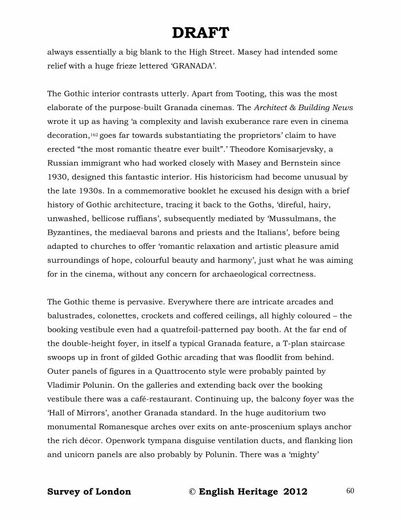
DRAFT always essentially a big blank to the High Street. Masey had intended some
relief with a huge frieze lettered ‘GRANADA’.
The Gothic interior contrasts utterly. Apart from Tooting, this was the most
elaborate of the purpose-built Granada cinemas. The Architect & Building News
wrote it up as having ‘a complexity and lavish exuberance rare even in cinema
decoration,162 goes far towards substantiating the proprietors’ claim to have
erected “the most romantic theatre ever built”.’ Theodore Komisarjevsky, a
Russian immigrant who had worked closely with Masey and Bernstein since
1930, designed this fantastic interior. His historicism had become unusual by
the late 1930s. In a commemorative booklet he excused his design with a brief
history of Gothic architecture, tracing it back to the Goths, ‘direful, hairy,
unwashed, bellicose ruffians’, subsequently mediated by ‘Mussulmans, the
Byzantines, the mediaeval barons and priests and the Italians’, before being
adapted to churches to offer ‘romantic relaxation and artistic pleasure amid
surroundings of hope, colourful beauty and harmony’, just what he was aiming
for in the cinema, without any concern for archaeological correctness.
The Gothic theme is pervasive. Everywhere there are intricate arcades and
balustrades, colonettes, crockets and coffered ceilings, all highly coloured – the
booking vestibule even had a quatrefoil-patterned pay booth. At the far end of
the double-height foyer, in itself a typical Granada feature, a T-plan staircase
swoops up in front of gilded Gothic arcading that was floodlit from behind.
Outer panels of figures in a Quattrocento style were probably painted by
Vladimir Polunin. On the galleries and extending back over the booking
vestibule there was a café-restaurant. Continuing up, the balcony foyer was the
‘Hall of Mirrors’, another Granada standard. In the huge auditorium two
monumental Romanesque arches over exits on ante-proscenium splays anchor
the rich décor. Openwork tympana disguise ventilation ducts, and flanking lion
and unicorn panels are also probably by Polunin. There was a ‘mighty’
Survey of London © English Heritage 2012 60

DRAFT Wurlitzer organ, regularly played by Reginald Dixon, in front of a large stage
under a fly tower; there could be theatrical productions as well as cinema.
The Granada made a huge impact. It ‘was truly magnificent and Woolwich had
never seen anything to equal it. . . . The whole interior was lit by subdued
lighting, enhanced by glittering chandeliers. Crimson velvet seats offered
comfort, which alone was a boon to cinema-goers used to faulty seating.’163
John Earl, latterly the doyen of British theatre history, went as a young boy in
the week that it opened. He ‘thought it was the most wonderful building [he]
had ever seen – in fact it triggered off a childhood interest in architecture. The
interior colours were then unbelievably brilliant.’164
But the Granada’s heyday was short. The café-restaurant was already disused
by 1953, and by the early 1960s Bingo was being played on Thursdays.
Granada was then promoting a development scheme that envisaged demolition
of the cinema, but that hit the buffers and when the cinema closed in 1966 it
was converted for full-time Bingo use; the organ was removed and the main
stalls seating was later replaced. Bingo ceased in 2011 and a further
conversion was proposed. This, to designs by Richmond (Sam and Paul
Stewart), aimed to introduce church use for the Christ Faith Tabernacle,
founded by Apostle Alfred Williams in Deptford in 1989.165
Gateway House (former Odeon Cinema)
Only slightly later, smaller and less ambitious than the Granada, the Woolwich
Odeon made a stronger outward statement of modernity. The proliferous Odeon
cinema chain, begun by Oscar Deutsch in 1928, had become known for its Art
Deco stylishness. The Woolwich cinema was planned from 1935, with George
Coles as architect. It had a capacity of just over 2,000 and the builder was
James Watt (Catford) Ltd.166
Survey of London © English Heritage 2012 61
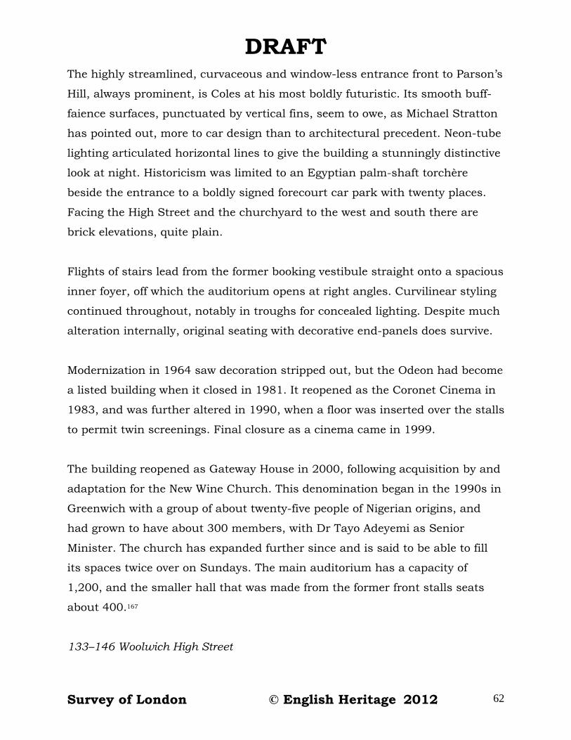
DRAFT The highly streamlined, curvaceous and window-less entrance front to Parson’s
Hill, always prominent, is Coles at his most boldly futuristic. Its smooth buff-
faience surfaces, punctuated by vertical fins, seem to owe, as Michael Stratton
has pointed out, more to car design than to architectural precedent. Neon-tube
lighting articulated horizontal lines to give the building a stunningly distinctive
look at night. Historicism was limited to an Egyptian palm-shaft torchère
beside the entrance to a boldly signed forecourt car park with twenty places.
Facing the High Street and the churchyard to the west and south there are
brick elevations, quite plain.
Flights of stairs lead from the former booking vestibule straight onto a spacious
inner foyer, off which the auditorium opens at right angles. Curvilinear styling
continued throughout, notably in troughs for concealed lighting. Despite much
alteration internally, original seating with decorative end-panels does survive.
Modernization in 1964 saw decoration stripped out, but the Odeon had become
a listed building when it closed in 1981. It reopened as the Coronet Cinema in
1983, and was further altered in 1990, when a floor was inserted over the stalls
to permit twin screenings. Final closure as a cinema came in 1999.
The building reopened as Gateway House in 2000, following acquisition by and
adaptation for the New Wine Church. This denomination began in the 1990s in
Greenwich with a group of about twenty-five people of Nigerian origins, and
had grown to have about 300 members, with Dr Tayo Adeyemi as Senior
Minister. The church has expanded further since and is said to be able to fill
its spaces twice over on Sundays. The main auditorium has a capacity of
1,200, and the smaller hall that was made from the former front stalls seats
about 400.167
133–146 Woolwich High Street
Survey of London © English Heritage 2012 62
DRAFT The Granada Cinema displaced a nineteenth-century row at 133–140 Woolwich
High Street, the formation of the ferry-approach roundabout accounted for a
block of the 1860s at 141–143 in 1964, and 144, which had been on an island
between Powis Street and Parson’s Hill with a few houses behind, had been
cleared in 1927 for a wider approach to Powis Street, which left a small green.
North of the former Odeon is the Mitre public house, its name suggestive of
proximity to the parish church. Established sometime around 1830 at the end
of an early eighteenth-century row that ran up Parson’s Hill, it had become
John Plume’s Mitre Music Hall by the 1880s. It was rebuilt in 1927–8, when
the Parson’s Hill green was formed, to ‘half-timbered’ Brewers’ Tudor designs
by Samuel A. S. Yeo, architect, with Harris and Wardrop, of Limehouse, as
builders. Little altered since, it closed in 2008. Adjacent to the west is Ferry
Cottage, a house that probably has early nineteenth-century origins, much
altered in 1993 when a shopfront was removed. Plans for an extension of the
New Wine Church onto this site were prepared in 2010, to designs by Joe
Edwards of Arcademy.168
West end of Powis Street
Abutting the former Granada Cinema to the east 170–172 Powis Street is a
doctor’s house and surgery of 1898–9, built after reversion of the property to
the Ogilby Estate for occupation by the family of Dr James Tees, an Irish-born
physician, surgeon and medical officer for the East Woolwich district. H. H.
Church was the architect and J. B. Sanford the builder. The consulting room
and dispensary were probably to the east on the ground floor. A double
datestone records the formation of Powis Street in 1798 as well as the
rebuilding.169 Nos 154–168 Powis Street was once a continuous terrace, built in
1899–1900 in a development by Robert James Warren that was supervised by
Church, with one D. Wilson as lessee and builder. The eight houses registered
sixty-four residents in the census of 1901, largely dependent on employment in
the Arsenal. Nos 160–162 were rebuilt for Furlongs in 1938–9 as their faience-
Survey of London © English Heritage 2012 63

DRAFT fronted showroom. The six that survive all have shops, inserted in 1937 after
road widening.170
Across Powis Street was the site (now the western part of a car park) of the
Salem Chapel of 1798–9, three by three bays, with a pilastered, pedimented
and rusticated front. This replaced a chapel on the Plumstead Road that the
Countess of Huntingdon’s movement had founded. Led by the Rev. J. Wilcox
Percy, the Salem Chapel thrived and was enlarged to the rear in 1829. It went
into decline after the foundation of the Rectory Place Congregational Church in
the 1850s.171
The chapel was incorporated into a school. Powis Street Schools, the London
School Board’s only establishment in Woolwich in its first decade, were built in
1873 on a site that extended further back. Infants used the former chapel and
older children were accommodated in a new two-storey rear block with shaped
gables, designed under E. R. Robson, for a total intake of 661. The children
were transferred to Mulgrave Place School and in 1903–4 the premises were
enlarged and converted, the former chapel to take thirty blind children, the
rear building for forty ‘mentally defective’ children on the ground floor, and
twenty deaf children on the first floor. From 1929–36 the premises were used
for adult education. They were ‘broken down’ in the 1950s, and the site was
cleared around 1960.172
From the 1840s Woolwich County Court sat at the Town Hall, but its facilities
had already been found wanting when the Woolwich and Greenwich branch
courts were amalgamated in 1928. The widening of this end of Powis Street in
1934–5 provided a site for a new building. The County Court of 1935–6 is one
of a number built around London in the inter-war years, and is typical of the
group, designed by the Office of Works in the ubiquitous brick and Portland
stone neo-Georgian manner that had been introduced by Sir Richard Allison.
The central public entrance is given strong emphasis, with rusticated quoining
Survey of London © English Heritage 2012 64

DRAFT that incorporates a royal monogram and date, with the royal arms above.
Following convention, a separate judge’s entrance is to the right, and, in
keeping with usual provision and the late nineteenth-century distinction
between a judge’s court and a registrar’s court, there are two courtrooms, that
to the rear lit by an octagonal lantern. There are also chambers for district and
circuit judges.173
The first buildings on the site to the north-west, built around 1805 on Bowater
property, formed a short row of the central-chimneystack type. These were
cleared for the road widening and their neo-Georgian shop and residential
successors were put up in 1937–8 for the Welling Estate Ltd, with Walters and
Blake as builders. The Castle Tavern (No. 179) is the successor to the Castle
Inn, a major Woolwich hostelry in the early nineteenth century when it was
used for petty sessions, rebuilt on a broader footing in 1937 for Watney and
Co., with C. H. Gibson as builders.174 Adjoining, 9 Parson’s Hill is a solitary
much-altered early nineteenth-century survival. Just to its west, where the
dual carriageway now sweeps, there used to be a small stucco-fronted Welsh
Chapel, built in 1806 before there were any roads hereabouts. This was used
as a synagogue from 1906–13 and subsequently as the Woolwich Animals’
Welfare Centre.175
Parson’s Hill Baptist chapel was built in 1857 across Parson’s Hill on what is
now the south-east corner of St Mary’s Gardens. H. A. Fisher was its architect.
From 1879 it was used by Woolwich Tabernacle, another Baptist congregation
led by John Wilson, who added new galleries in 1880. Wilson moved to
Beresford Street and the building was purchased by the Royal Arsenal Co-
operative Society in 1901 for use as the Co-operative Institute, an education
centre which from 1921 hosted Saturday-morning cinema for children. The
building was demolished in the 1960s in the remaking of John Wilson Street.176
Beresford Street area
Survey of London © English Heritage 2012 65
DRAFT George Smith, identified in a lease as a wine merchant of Park Row, Greenwich,
acquired the government’s Woolwich ropeyard in 1832. This George Smith was
not the man appointed surveyor to Morden College, Blackheath, in 1830, nor is
it evident that he was the other namesake who was Secretary to the Navy
Board in 1830–1, but he may have been the man who had a ropemaking
business in Powis Street. If so and he had plans to manufacture rope at the
naval ropeyard, they had already been abandoned by 1833 in favour of
clearance for a new road. Smith laid this straight street along the south-west
side of his property, giving himself development plots that backed onto
Ropeyard Rails. Much of the other side was on the Powis estate. The street
issued to the south at the Arsenal’s Beresford Gate of 1828–9, from which its
name derived. By 1838 Beresford Street had a scatter of eighteen houses, two
of them pubs – the Victoria, later the Beresford Arms, at the north end of the
east side, and the Duke of Sussex, midway along the west side; there was also
a theatre. Thirteen more houses went up in 1842–3, and further activity up to
1847 filled remaining frontages.177 A number of these two-storey houses, at
both ends and on both sides, were double-fronted and just one room deep,
despite having, in most cases, deeper plots.
Horse-trams ran down the road from 1881 and there were soon projects to
make it broader.178 But these came to nought until development schemes of the
1950s changed the picture. The road was eventually widened on its south-west
side in two phases, at the north end by the LCC prior to the building of
Riverside House in the early 1960s, and southwards from the Macbean Street
junction in the 1980s when the GLC rerouted traffic behind Beresford Gate.
Much of the north-east side had been subject to a slum-clearance project in
the late 1950s, the early buildings further south coming down in the 1970s.
Light-industrial buildings of the 1960s were in turn cleared in 2007. Most of
the north-east side awaits redevelopment in 2012. This account of the street’s
more significant buildings, demolished and extant, is arranged in a loosely
chronological sequence.
Survey of London © English Heritage 2012 66

DRAFT
Holy Trinity Church (demolished)
Soon after the sale of the ropeyard a project for a new church sprung up; there
was no place for Anglican worship anywhere near what was becoming the
commercial centre of Woolwich. A local group that included some eminent
military figures – Col. Sir John Thomas Jones, RE, and Col. Sir Alexander
Dickson, RA, formed the Woolwich Proprietary Chapel Company and speedily
raised funds through a share subscription, a rare achievement. The company
bought the south-easternmost part of Smith’s ground, took on John Douglas
Hopkins as architect, and built a substantial chapel in 1833–4. Holy Trinity
could accommodate 1,838. The liturgical east end was placed north-west so
that the building could be entered from Beresford Square, to which it presented
an imposing Greek Revival Portland stone façade that married a tower like that
at St Mark, North Audley Street (by J. P. Gandy Deering), with a prostyle Ionic
portico like that at St Mary, Greenwich (by George Basevi). The nave elevations
were plain brick with pilaster strips and there was only the shallowest of
chancels. Slim cast-iron columns divided a hall-like galleried interior.179
The first minister was the Rev. Capel Molyneux, ‘an eloquent and Calvinistic
Irishman’,180 who brought people flocking and made Holy Trinity the most
fashionable church in Woolwich. In this proprietary chapel sittings were kept at
high rents, excluding the poor. Molyneux built a school behind the church in
1846, to accommodate 140 children. But a falling out between the congregation
and a new minister in 1850–1 led Henry Brown, the Rector of Woolwich, to buy
out the shareholders, aided by a gift of £1,000 from the Board of Ordnance,
and to make Holy Trinity a chapel of ease to the parish church. It was
consecrated, for the first time, by Bishop Blomfield in 1852. There was a
reseating with the central pulpit moved to one side in 1883–4, work carried out
by H. H. Church, and the school building was enlarged towards Ropeyard Rails
in 1892–3. A refurbishment of 1930–1 saw the portico removed, to make space
for tram queues, and the chancel plainly reordered to the designs of Frederick
Survey of London © English Heritage 2012 67

DRAFT Etchells. The church was closed in 1960 and demolished in 1962, its site
bought by Woolwich Borough Council for road widening.181
Empire Theatre (former Theatre Royal, demolished)
J. F. Savill’s travelling theatre set up on Smith’s side of Beresford Street in
1835 in a portable building, probably cast-iron framed. This was designated
the West Kent Theatre and had assumed the prefix ‘Royal’ by 1837 when it
opened a permanent building – three-bay pediment-fronted and chapel-like,
end on to the street, a standard small theatre of its time. Briefly also called the
Duchess of Kent, the venue settled by 1839 to being known as the Theatre
Royal. This was substantially enlarged southwards in 1884 by the addition of a
five-bay block that permitted a new auditorium parallel to the street with a
capacity of 420, work that appears to have been carried out through Frank
Matcham, architect, with Samuel Barnes, of Powis Street, acting as builder for
H. J. Borley and Munro of Astley’s Theatre in Lambeth. Samuel Barnard, from
Peckham, took over and a second extension followed in 1893, taking the
premises further south to wind up with a symmetrical tripartite façade and a
capacity of 825, this time with Edward Clark as architect. Another
reconstruction for Barnard ensued in 1899–1900, Matcham returning to work
with Thomas & Edge, builders, to raise the building a storey and reconstruct
the interior for another doubling of capacity. Though lavish enough, this was
not one of Matcham’s grander theatres.182 It was, in fact, a music hall, with a
line in sensational, if not lurid, productions. A visitor in 1900 found the theatre
‘crammed, about 2,000 people, not more than 12 soldiers in uniform and
hardly 50 women. The rest all young men and boys.’183 Cinema, introduced by
1913, became the only use in 1931 at what had been renamed the Woolwich
Empire, but only until 1937 when variety performances returned. The Empire
ended up as a strip-joint before its license was taken away in 1958. The
building was demolished in 1960.184
Chapels and missions
Survey of London © English Heritage 2012 68
DRAFT A short distance north-west from the theatre there was a Wesleyan Association
Chapel of 1840. The Salvation Army had this in the 1890s, and it was still a
chapel in the 1920s. It was last used as the Hostel of Our Lady. John
Churchill, a resident as a child in the 1930s recalled ‘in one corner of a ver big
room was two forms, one woode table and a big wooden cubbard to keep food
in. There was about five famileys in that room, each hade old woode forms and
an old woode tables and a big coal fire in wich we all sat around. Onley
mothers and childre were allowed in the hostel, no men. . . . The was onley one
out side toilet, no barthroom, we all at to got to the public barthes.’185 The
hostel was demolished in the early 1950s.186
Across Ropeyard Rails, on the site of the former watch-house, at the High
Street (Warren Lane) corner, was St Saviour’s Mission School Church, built in
1873, deep in the impoverished Dusthole. Designed by Arthur Blomfield, in
advance of his work on the parish church, this was a plain but handsome brick
building with a robust dignity befitting a mission in such a deprived quarter. It
was used as auction rooms before it was demolished in 1959.187
Near the High Street end of the north-east side of Beresford Street, the
Salvation Army, with E. J. Sherwood as architect, built a local headquarters in
1884, known as its ‘barracks’ or as a temple. A simple hall, this was a base for
missionaries on the edge of the Dusthole, from which the aim was to rescue
prostitutes and other fallen souls. The castellated building was converted to
commercial use in the 1960s and demolished in 2007.188
Pastor John Wilson, ‘a great burly Scotchman’189 who had come to Woolwich on
the recommendation of Charles Spurgeon, had a peripatetic Baptist
congregation in Woolwich from about 1877. He built it up and then in 1895–6
erected the Baptist Tabernacle, a vast place of worship, to designs by Walter
Henry Woodroffe, architect, with J. Smith & Sons of South Norwood as
builders. The red-brick and stone-dressed classical front gave onto a large
Survey of London © English Heritage 2012 69

DRAFT galleried interior with seating for 2,000. As with earlier foundations in the
vicinity, the location was chosen with a view to missionary improvement in the
Dusthole. But Wilson’s membership was mainly from artisan families, hailing
from a wide area. Membership dwindled and the building was last used for
worship in 1969; it was demolished soon after. The congregation moved to a
site off Sandy Hill Road, exchanging properties with the council.190
Union Street
The south-west side of Beresford Street was once a neighbourhood of small
houses. Into this a school was introduced in 1884.
The block bounded by Creton and Macbean streets, where a supermarket
stands, was laid out at the beginning of the nineteenth century for the Powis
Estate as a rectangle of streets called Union Street and Union Place, linked to
the High Street by Gough’s Yard and otherwise only accessible from Powis
Street. Between 1807 and 1813 some plots were developed with about forty
fourth-rate houses. Little more was done until the frontages were fully built up
in the early 1850s, with the northern arm then called Union Buildings; there
was no link through to Beresford Street until 1871. In the early 1880s the area
was thought to be outside the ‘colony of idle dissolute people’ that was the
Dusthole,191 but whether through actual or perceived decline, it came to be
tarred by association. Most of the houses were replaced in 1898–1900.192
Across Union (now Macbean) Street there had been open ground, a builder’s
yard. The School Board for London moved to acquire this for what was to
become Union Street School in 1881, despite some dissent about the risks of
falling between two stools on a site at the margin between areas of slums and
respectability. The school was built in 1883–4, at first to accommodate 600 in
nine schoolrooms, but immediately enlarged to make space for another 200,
with designs, signed off by E. R. Robson, that left further enlargement a
possibility.193 Asymmetries in the Domestic Revival building, less studied than
Survey of London © English Heritage 2012 70
DRAFT incidental, perhaps marked this stuttering start, though the side elevation to
Macbean Street was regular, with decorative panels bearing the school’s name
and date.
In 1920–1 the LCC remodelled and enlarged the school in the south-eastern
direction always intended, to stripped Arts and Crafts designs, probably
prepared by W. A. Richards. The irregularly massed additions had large
windows for better cross-ventilation, standard for the time. They allowed the
infants and a babies’ room to be accommodated below the girls, with the boys
and their practical workrooms on top. There were now eighteen classrooms and
three halls in what remained ‘an extremely squalid and depressing part of
Woolwich’.194 Attendance fell to below 200 before the school was renamed Powis
LCC School in 1938, with the upper floors used for Woolwich Polytechnic
evening classes. It became the Woolwich Polytechnic Secondary Technical
School for Boys in 1956 and then Woolwich Polytechnic Lower School.195 It was
emptied in 2006 and demolished in 2011. There are no public plans for the
empty site.
South-east of the school a large open area behind the Beresford Street houses
was filled in 1889–90 by a Drill Hall for the Third West Kent Rifle Volunteers.
This was 150ft (46m) long and top-lit, and had a boisterous sub-Vanbrughian
rusticated gatehouse. Later used by the Woolwich and Plumstead Synagogue
(1913–25), the YMCA, and for boxing, dancing and other public events, it was
demolished around 1970, save for its south wall. The site has since been used
as a market pound for the traders of Beresford Square.196
Riverside House
The somewhat anomalous tower that is Riverside House was the main product
of, and is now the only survival from, a post-war development sweep across
Beresford Street.
Survey of London © English Heritage 2012 71

DRAFT In 1952 Woolwich Borough Council began to plan for the relocation of business
premises from its St Mary’s Comprehensive Development Area, zoned as purely
residential. To this end it designated for commercial use an already part-
cleared site south-west of the junction of Beresford Street and Woolwich High
Street, making the Hough Street Relocation Area; Gough’s Yard and its Union
Street continuation had become Gough Street in 1904 and then Hough Street
in 1938. Early assumptions were that there would be several small commercial
premises, above which flats might be built – W. H. Gimson could not foresee
demand for offices. However, what little interest there was fell away and in
1957 the Ministry of Works suggested building offices, dangling the possibility
that it would lease some for its own civil servants. A newly formed property
development group, Gula Investments, previously Gula-Kalumpong Rubber
Estates in Malaya, took this up with Arthur Swift and Partners, architects,
projecting two buildings in 1958, one of three storeys, the other a nine-storey
point block. Another office tower was planned for central Woolwich at the same
time, and, with no firm government commitment, there was nervousness about
the market for offices in this location. The LCC completed the widening of the
roads in front of the site in 1961 and the plans were revised to comprise a
seventeen-storey tower and a five-storey L-plan block along Beresford Street.
The latter was to include shops until that was vetoed by the LCC – shops would
encourage drivers to stop their cars on the intended through route. In the
event, Woolwich Polytechnic was lined up to lease the lower building, the
height of the tower came down to fourteen storeys and the project gained
planning permission, the first large office building in south-east London so to
do. Woolwich Borough Council launched the project as the ‘beginning of
Woolwich as a new commercial centre’.197 The blocks were built in 1962–3, with
Bylander, Waddell and Partners as consulting engineers and Tersons Ltd as
builders. Gula Investments (also then building St Andrew’s House, Sauchiehall
Street, Glasgow, with the same architects) publicly proclaimed faith in the
potential of eastern parts of London to sustain such development, but
remained concerned by the proximity of ‘obsolete’ buildings, thinking likely
Survey of London © English Heritage 2012 72

DRAFT tenants would be put off. In 1963 the firm submitted a scheme for the whole
area west to Hare Street, rejected by the Council which reserved the initiation
of such a large project to itself, thinking it not the place of a private
developer.198
In 1964 J. T. Stratford & Sons, Woolwich barge builders, took a lease of the top
floor in what had (misleadingly) been dubbed Riverside House. Other space was
slow to let, but the block was gradually filled by the LCC Architect’s
Department, Greenwich Council’s Children’s Department, the London
Electricity Board, the British Egg Marketing Board and Artizans and General
Properties Ltd. Many others have followed, latterly in tax offices. The
Polytechnic retained the lower block into the 1990s.199
These starkly utilitarian buildings have precast concrete-panel walls faced with
‘white Norwegian quartzite’, on reinforced-concrete frames with outer load-
bearing columns that terminate as pilotis to part-open ground floors. Beyond a
small sett-paved courtyard, arboreal but desolate, the High Street frontage was
left open for car parking. John Betjeman described Riverside House as ‘an
absolutely square block built solely with the intention of making money and
not to make Woolwich beautiful’.200 The application to the tower of blue paint in
a mottled pattern has scarcely helped. Riverside House was put up for sale in
2011 as a ‘development opportunity’.
Ropeyard Rails industrial area
Redevelopment of most of the area between Beresford Street and Warren Lane
happened in parallel with the Riverside House project. The LCC had put
forward a Ropeyard Rails slum-clearance area in 1939, and then there was
some bomb damage. Woolwich Borough Council took responsibility from the
LCC and in 1952, to help with its St Mary’s redevelopment, zoned the area for
light industry and car parking. This had endured as the place with the worst
housing in Woolwich, so what residential use remained was pushed out.
Survey of London © English Heritage 2012 73

DRAFT Between 1957 and 1964 a number of low-lying industrial premises were built,
offices and sheds for building contractors, a four-storey shoulder-pad and zip-
fastener factory, a printing works and a wholesale chemist’s warehouse, most,
if not all, designed by Eley and Rickcord, architects. All was cleared in 2007 for
use as a car park pending redevelopment through Berkeley Homes.201
The Autostacker (demolished). One building from this phase, much the most
interesting, did not last so long. In a determined attempt to get to grips with
the town-centre’s parking problems Woolwich Borough Council co-ordinated
the building of a multi-storey car park with the introduction of parking meters.
Various sites for this car park were considered and in 1958 W. H. Gimson
reported in favour of Ropeyard Rails, presenting two alternative schemes for
the parking of 500 cars, via ramps or mechanization. There were no
mechanized car parks in Britain at the time, but Gimson had learned about
overseas models. He contacted the Mitchell Engineering Company, which was
developing ideas for a structure wherein drivers would leave locked cars on the
ground in lifts, from the tops of which dollies would move the cars into densely
packed bays. There was also a visit to a ‘semi-mechanised’ facility in
Birmingham. The project became a collaboration when Shell-Mex and BP Ltd, a
joint marketing venture, agreed to buy the site, that of the Empire Theatre, and
to run a petrol station and ground-level workshops while the Council saw to
the building and running of the car park. The plan for two eight-storey
structures involved closing the southern part of Ropeyard Rails. In 1959 the
Parking Research Co., with T. and P. Braddock as architects, worked up a
detailed scheme for what aimed to be the country’s first fully automatic car
park, to patented designs including a scale model by Auto-Stackers Ltd. These
were devised through the inventiveness of one of that firm’s directors, Col. J. A.
Stirling, a Scottish civil engineer, who started from a Meccano model and
adapted methods used for stacking timber to the conveyors, lifts and dollies
principle. This gained the support of Shell-Mex and B.P. Ltd, the Borough
Council and the LCC. It went up at the same time as the comparable Zidpark
Survey of London © English Heritage 2012 74

DRAFT at Southwark Bridge, but that was not a local-authority project. The Borough
Council’s Development Committee’s minutes noted defensively that it was ‘a
somewhat ambitious scheme, but there is no reason why Woolwich should not
be pioneers’. The Autostacker was built in 1960–1 with four lifts for lodging
256 cars on its open decks. Automation systems were supplied by Standard
Telephones & Cables.202
‘Hats off to the Borough of Woolwich! This lively, go-ahead part of London is
setting an example in dealing with its parking problem that ought to be studied
– and copied – by local authorities up and down the country.’203 So said The
Motor magazine, and when the Autostacker was opened by Princess Margaret
on 11 May 1961 most of its spaces had already been booked under contract.
But it could not be made to function properly at the opening, not even for Fyfe
Robertson on the Tonight television programme, nor soon after, and numerous
subsequent tests failed to persuade the Council that it was reliable. Robert L.
Gee, who had succeeded Gimson in March 1960, had, before the opening,
refused to certify payments because of concerns about operability. Stalemate
resulted until the Council took possession in 1963, charging Auto-Stackers Ltd
with failure to complete its contract. Ignominiously, the Autostacker was
demolished in 1965–6.204
Royal Sovereign House and Macbean Street supermarket
The former Union Street block, the roads of which had been renamed Bunton,
Creton, Hough and Macbean streets, had come up for consideration as a site
for a multi-storey car park in 1956–8, to be built by the landowner, the Ogilby
Estate. When the Autostacker failed the idea was revived, and in 1962–4 the
Estate intended a ramped multi-storey garage with a six-storey office block.
The land then became one of several parcels that the Ogilby Estate sold to
Chesterfield Properties Ltd. In 1966 that firm proposed development across the
whole south-west side of Beresford Street up to the backs of properties in Powis
Street and Hare Street, offering new roads and a pedestrian shopping precinct
Survey of London © English Heritage 2012 75

DRAFT alongside the car park and office block. Houses began to be cleared and a bus
station came into the scheme. Chesterfield Properties and Greenwich Council
joined together and, after three years planning, in early 1971 unveiled a grand
project for an enclosed and air-conditioned shopping centre – ‘there will be
“malls” or paths, between the shops’, the council explained. This was to be
under a twelve-storey office block, with a bus station alongside under a car
park. The architect was Max Gordon of the Louis de Soissons Partnership.
There were difficulties over the acquisition of sites on the south side of
Macbean Street and the scheme was withdrawn.205
A much reduced plan emerged from Chesterfield Properties in 1978, initially as
a single block linked to Riverside House, but worked up in 1979 by the same
architects and the Bylander Waddell Partnership, consulting engineers, to be
an office block on Beresford Street, in front of a supermarket with basement
parking, effacing Hough Street. These were built in 1980–1. Unrelieved red-
brick-clad elevations with curved corners rise to turrets on the five-storey office
building. Named Royal Sovereign House, presumably after the ship of 1701
built in Woolwich, it came to be occupied by Hyde Housing and Maritime
Greenwich College, for international students. The supermarket was opened by
Presto and then taken by Safeway, before being divided for Lidl and a gym.206
On Bunton Street (once Union Buildings and then Myrtle Street) adjoining the
south entrance to Callis Yard is Qube House, a seven-storey block of fourteen
flats, grey-clad with patterned green panels. This was built in 2008–9, by
Grangewalk Developments to designs by FCS Building Design Consultants with
Solidoak Ltd, building contractors. It replaced the Union Arms, a tavern of
1936.207
The Baptist Tabernacle was replaced with the Woolwich Catholic Club, built
in 1979–80 after plans to relocate the club from its former premises on
Woolwich New Road to General Gordon Square foundered. It was designed by
Survey of London © English Heritage 2012 76
DRAFT
Survey of London © English Heritage 2012 77
Robinson, Kenning and Gallagher, architectural consultants, working under J.
W. Kennedy & Co., surveyors, with Sykes and Son as builders. It is a low and
severe range with plain brown-brick facing and tinted windows in black
anodized aluminium frames.208 The rerouting of the south end of Beresford
Street left a triangle of open land beside the club. This was landscaped and
paved with benches round a circle; it is scarcely used.
Berkeley Homes
A ‘masterplan’ for the development of a large cleared site, essentially the north-
east half of the area covered in this chapter, was put forward by Berkeley
Homes in 2004. This aimed to take that company’s regeneration work at the
Arsenal westwards as far as the Waterfront Leisure Centre’s car park, the
former Gun Wharf site, which Greenwich Council sold to the developer. Allies
and Morrison Architects prepared a revised scheme in 2007–8. This envisages
the effacement of Warren Lane for a realignment of Royal Arsenal Gardens
following the axis of the old ropeyard (part of the new layout was proposed as
Rope Yard Square). There are to be flanking buildings along Beresford Street
and the Arsenal up to the river. This configuration arises from the need to
allow for the rising tunnel of Crossrail as it approaches a station in the former
Arsenal.209
In 2009 Geminex Hotel and Leisure Management acquired a part of the former
Ropeyard Rails area for a 130-bedroom six-storey Holiday Inn Express.
Berkeley Homes (Urban Renaissance) Ltd and then the Key Homes Group took
this forward in 2010–11 with designs by Allies and Morrison Architects for a
Royal Arsenal Hotel on the north side of Beresford Street, due to open in
2013.210