chapter 1 homework - elements of real estate...
TRANSCRIPT

Chapter 1 Homework - Elements of Real Estate Law
The following questions are a small example of what you might expect to see on the Real Estate Law portion of the Cadastral Mapping exam.
First try answering the questions below without the manual, then use your manual to check your answers.
True or False
1. T F The tax serial number or parcel number noted on a document is considered part of
the legal description.
2. T F County Recorders transmit copies of all the ownership plats to the County Assessor
showing the ownership as of January 1st at Noon.
3. T F Recording gives notice to all persons of the contents of the recorded document.
4. T F Title to the vacated street, or road shall vest to the adjoining record owner, with the
entire width of the road assessed to one of the adjoining owners.
Fill in the Blank
5. ______________________ means; a property in whose name the title appears in the public
records, or a stockholder of record.
6. ______________________ means; an interest in land that, being the broadest property
interest allowed by law.
7. ______________________ means; an undeveloped area of land set aside for farmland or
preserved as natural wilderness.
8. A _____________________ when executed shall have the effect of a conveyance in fee
simple to the grantee, and the grantor guarantees that the property is free from all
encumbrances and will forever defend the title against all lawful claims whatsoever.
Multiple Choice
9. A municipality is a:
A) City B) Town C) Metro Township
D) All of the above
10. Before any unit from a condominium plat can be conveyed this document must be recorded:
A) Warranty Deed B) Easement C) Declaration of CC&R’s
D) HOA Agreement
11. Upon the death of the sole trustee or the last surviving trustee, the trust estate passes to:
A) The heirs B) The appointed successor C) Any blood relative
D) A personal representative
12. A document that is of record in the county recorder’s office may not be recorded again in that same county recorder's office unless:
A) It has been reexecuted by all parties. B) A minor typographical error is corrected. C) The legislative body approves it. D) It contains a brief statement explaining the reason for rerecording. E) It is electronically recorded. F) Both B and C G) Both C and E H) Both A and D I ) None of the Above

Chapter 2 Homework
TITLE SEARCHING PRACTICAL EXERCISE
As a practical application of the principles of title searching and ownership discovery, this practical exercise will lead the cadastral mapper through typical land records. Copies of such records are included herein, and the student should answer the questions found at the end of this exercise.
The following resources are provided:
• Ownership Plat of HOLMES CREEK SUBDIVISION, a part of the Northwest Quarter of Section 27, Township 4 North, Range 1 West, Salt Lake Base and Meridian, U. S. Survey
• Dedication Plat of HOLMES CREEK SUBDIVISION • Section Ownership Plat, NW ¼, Section 27, T4N, R1W, SLB&M • Pages extracted from the Abstract for Section 27, T4N, R1W, SLB&M • Pages extracted from the Abstract for HOLMES CREEK SUBDIVISION • Pages extracted from the computer abstract for Parcel 11-058-0026
QUESTIONS: Using the resources available, fill in the complete abstract of title showing all of the documents in the index previous to the computer for parcel 11-058-0026. Then use both the computer abstract and your written abstract of title to answer the following questions about parcel 11-058-0026:
1. What is the legal description of the property?
2. What is the situs address of the property?
3. What are the dimensions of the Lot?
4. What is the acreage of the Lot?
Chapter 2 Homework
5. Who was the tax title owner(s) as of 10/13/2010?
6. What easements are apparent from given resources?
8. Who was the owner of record on August 20, 1974, of the real property which became this subdivision lot?
9. On what date was this subdivision dedicated?
10. On what date was this subdivision recorded?
11. What was the first document after the subdivision plat that transferred parcel 11-058-0026 to a husband and wife as joint tenants (Etux)?
12. How many times since the subdivision plat has been recorded has this property transferred ownership?

Chapter 2 Homework

Chapter 2 Homework
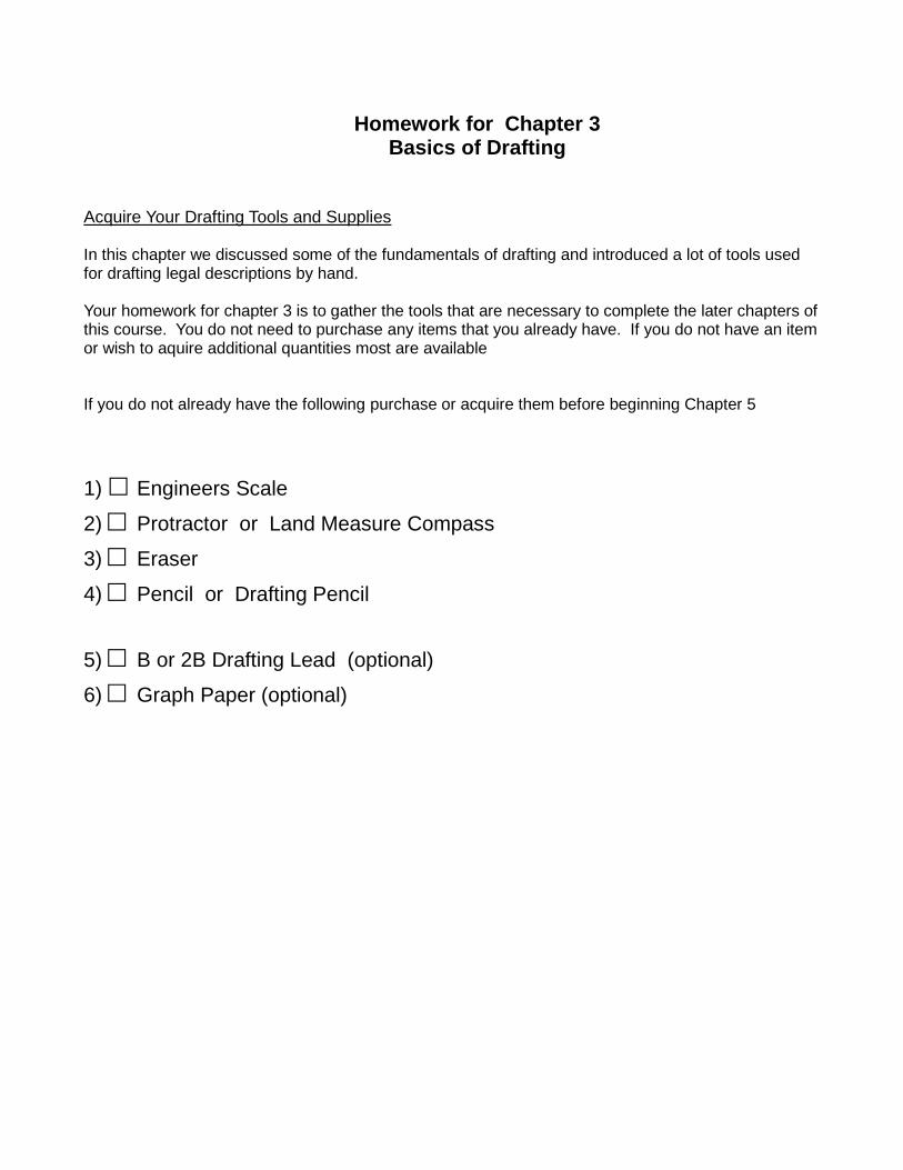
Homework for Chapter 3
Basics of Drafting
Acquire Your Drafting Tools and Supplies In this chapter we discussed some of the fundamentals of drafting and introduced a lot of tools used for drafting legal descriptions by hand. Your homework for chapter 3 is to gather the tools that are necessary to complete the later chapters of this course. You do not need to purchase any items that you already have. If you do not have an item or wish to aquire additional quantities most are available If you do not already have the following purchase or acquire them before beginning Chapter 5
1) □ Engineers Scale 2) □ Protractor or Land Measure Compass 3) □ Eraser 4) □ Pencil or Drafting Pencil 5) □ B or 2B Drafting Lead (optional) 6) □ Graph Paper (optional)

Engineers Scale - Available for purchase on Amazon.
Protractor - Available for purchase on Amazon.
-OR-
Land Measure Compass - Available for purchase on Amazon.
- I recommend the Land Measure Compass instead of a traditional protractor because it is designed to be used for legal description bearings.
Drafting Pencil - Available for purchase on Amazon.
(We won’t be drafting on film for this class so a regular mechanical pencil should work ok.)
- I recommend .07mm because the softer drafting
lead doesn’t break as easily.
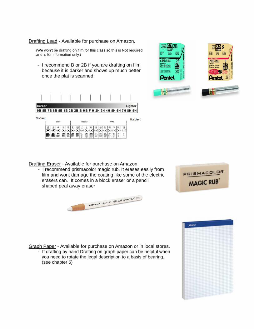
Drafting Lead - Available for purchase on Amazon.
(We won’t be drafting on film for this class so this is Not required and is for information only.)
- I recommend B or 2B if you are drafting on film
because it is darker and shows up much better once the plat is scanned.
Drafting Eraser - Available for purchase on Amazon.
- I recommend prismacolor magic rub. It erases easily from film and wont damage the coating like some of the electric erasers can. It comes in a block eraser or a pencil shaped peal away eraser
Graph Paper - Available for purchase on Amazon or in local stores.
- If drafting by hand Drafting on graph paper can be helpful when you need to rotate the legal description to a basis of bearing. (see chapter 5)
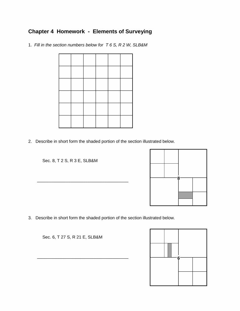
Chapter 4 Homework - Elements of Surveying
1. Fill in the section numbers below for T 6 S, R 2 W, SLB&M
2. Describe in short form the shaded portion of the section illustrated below.
Sec. 8, T 2 S, R 3 E, SLB&M
______________________________________
3. Describe in short form the shaded portion of the section illustrated below.
Sec. 6, T 27 S, R 21 E, SLB&M
______________________________________
8
6
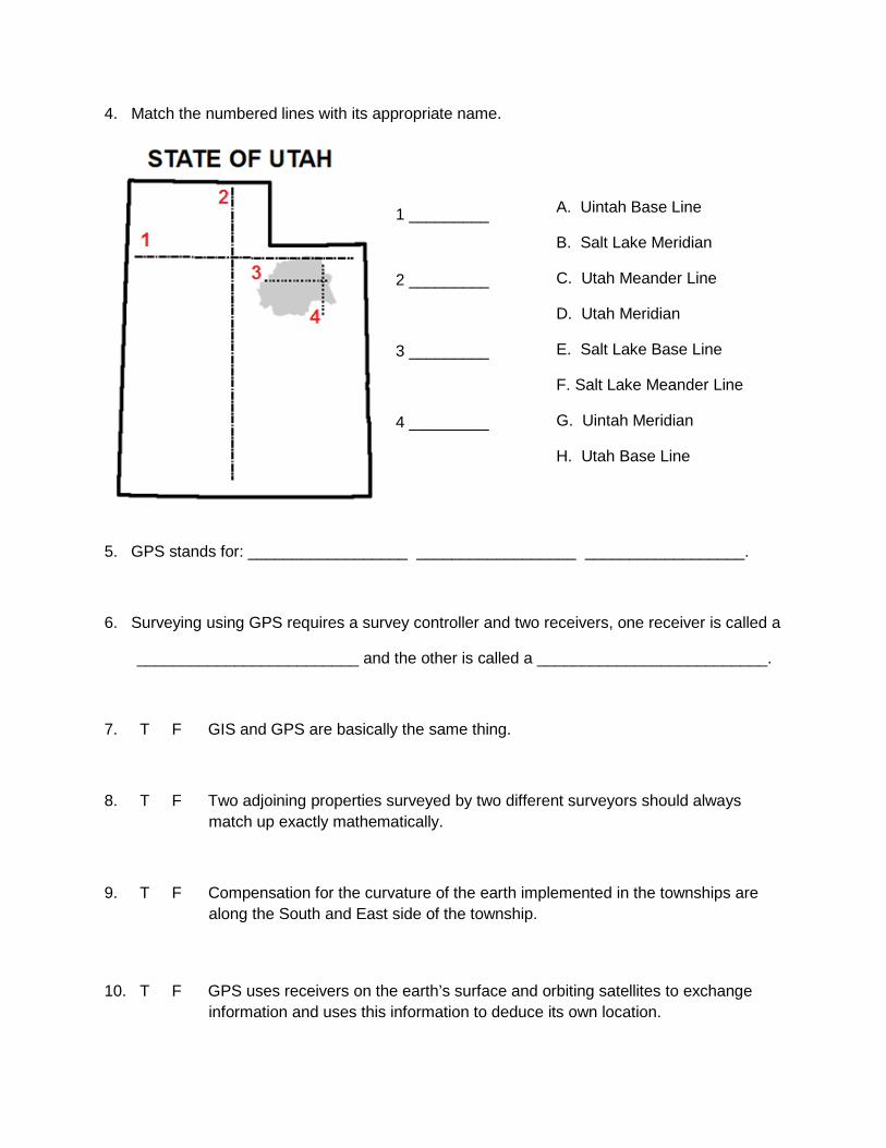
4. Match the numbered lines with its appropriate name.
1 _________
2 _________
3 _________
4 _________
5. GPS stands for: __________________ __________________ __________________.
6. Surveying using GPS requires a survey controller and two receivers, one receiver is called a
_________________________ and the other is called a __________________________.
7. T F GIS and GPS are basically the same thing.
8. T F Two adjoining properties surveyed by two different surveyors should always match up exactly mathematically.
9. T F Compensation for the curvature of the earth implemented in the townships are along the South and East side of the township.
10. T F GPS uses receivers on the earth’s surface and orbiting satellites to exchange information and uses this information to deduce its own location.
A. Uintah Base Line
B. Salt Lake Meridian
C. Utah Meander Line
D. Utah Meridian
E. Salt Lake Base Line
F. Salt Lake Meander Line
G. Uintah Meridian
H. Utah Base Line
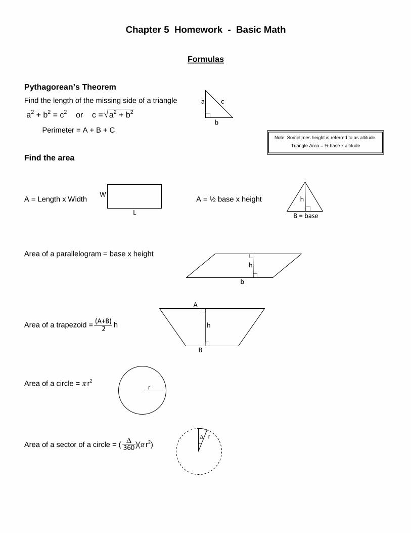
Chapter 5 Homework - Basic Math
Formulas
Pythagorean’s Theorem Find the length of the missing side of a triangle
a2 + b2 = c2 or c =√ a2 + b2
Find the area
A = Length x Width A = ½ base x height
Area of a parallelogram = base x height
Area of a trapezoid = h
Area of a circle = 𝜋 r2
Area of a sector of a circle = ( )(𝜋 r2)
h B = base
a c b
W L
Note: Sometimes height is referred to as altitude.
Triangle Area = ½ base x altitude
h b
360
Perimeter = A + B + C
r
r
(A+B) 2
A h B
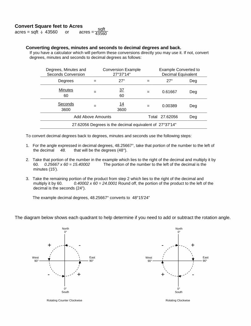
Convert Square feet to Acres acres = sqft : 43560 or acres =
Converting degrees, minutes and seconds to decimal degrees and back.
If you have a calculator which will perform these conversions directly you may use it. If not, convert degrees, minutes and seconds to decimal degrees as follows:
Degrees, Minutes and Seconds Conversion
Conversion Example 27°37'14"
Example Converted to Decimal Equivalent
Degrees = 27° = 27° Deg
Minutes = 37 = 0.61667 Deg 60 60
Seconds = 14 = 0.00389 Deg 3600 3600
Add Above Amounts Total 27.62056 Deg
27.62056 Degrees is the decimal equivalent of 27°37'14"
To convert decimal degrees back to degrees, minutes and seconds use the following steps:
1. For the angle expressed in decimal degrees, 48.25667°, take that portion of the number to the left of the decimal 48. that will be the degrees (48°).
2. Take that portion of the number in the example which lies to the right of the decimal and multiply it by
60. 0.25667 x 60 = 15.40002 The portion of the number to the left of the decimal is the minutes (15').
3. Take the remaining portion of the product from step 2 which lies to the right of the decimal and
multiply it by 60. 0.40002 x 60 = 24.0001 Round off, the portion of the product to the left of the decimal is the seconds (24”).
The example decimal degrees, 48.25667° converts to 48°15'24”
The diagram below shows each quadrant to help determine if you need to add or subtract the rotation angle.
_ sqft 43560
- +
+ -
North 0°
0° South
East 90°
West 90°
Rotating Counter Clockwise Rotating Clockwise
North 0°
0° South
East 90°
West 90°
+ -
- +
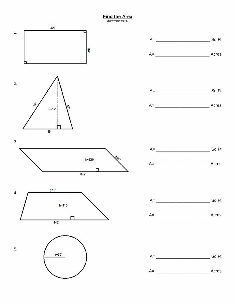
Find the Area
1.
A= _______________________ Sq Ft
A= _______________________ Acres
2.
A= _______________________ Sq Ft
A= _______________________ Acres
3.
A= _______________________ Sq Ft
A= _______________________ Acres
4.
A= _______________________ Sq Ft
A= _______________________ Acres
5.
A= _______________________ Sq Ft
A= _______________________ Acres
Show your work.

Find the Areas of the following
6.
A= _______________________ Sq Ft
A= _______________________ Acres
7.
A= _______________________ Sq Ft
A= _______________________ Acres
8.
A= _______________________ Sq Ft
A= _______________________ Acres
9.
A= _______________________ Sq Ft
A= _______________________ Acres
10.
A= _______________________ Sq Ft
A= _______________________ Acres
Show your work
Find the Areas of the following
11.
A= _______________________ Sq Ft
A= _______________________ Acres
12.
A= _______________________ Sq Ft
A= _______________________ Acres
13.
A= _______________________ Sq Ft
A= _______________________ Acres
14.
A= _______________________ Sq Ft
A= _______________________ Acres
15. Find the area of the shaded portion.
A= _______________________ Sq Ft
A= _______________________ Acres
Show your work
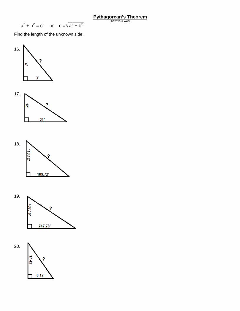
Pythagorean’s Theorem
a2 + b2 = c2 or c =√ a2 + b2
Find the length of the unknown side.
16.
17.
18.
19.
20.
Show your work
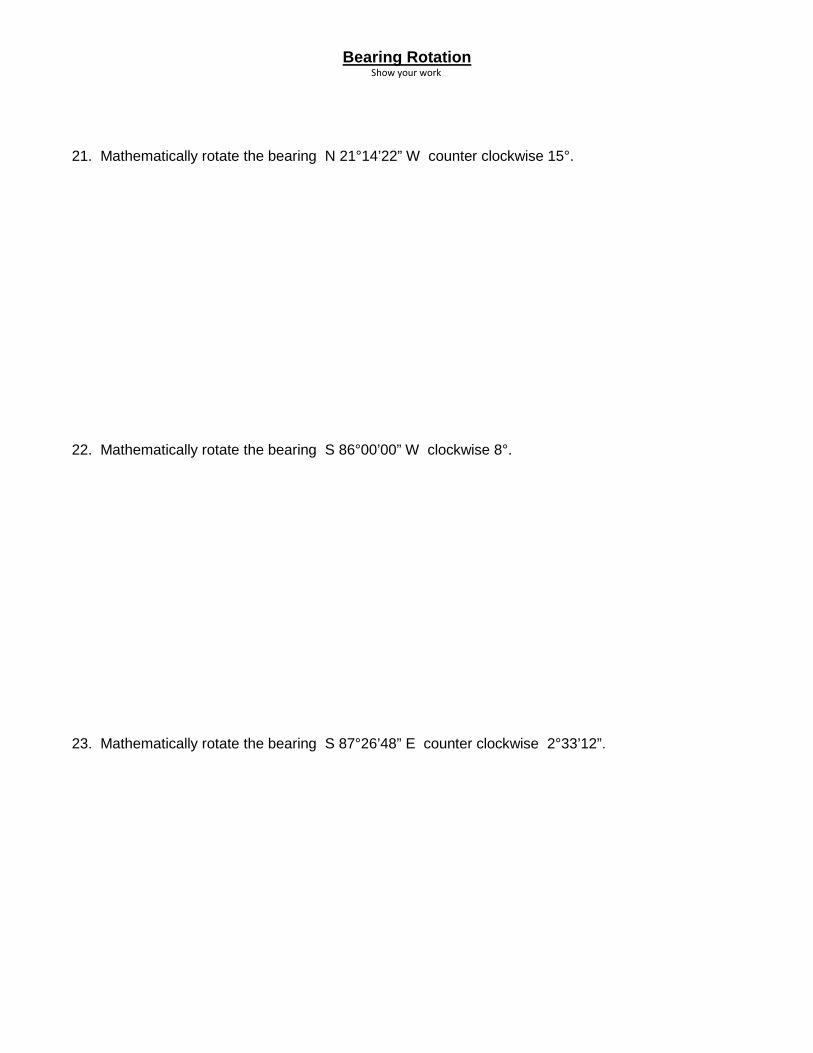
Bearing Rotation
21. Mathematically rotate the bearing N 21°14’22” W counter clockwise 15°.
22. Mathematically rotate the bearing S 86°00’00” W clockwise 8°.
23. Mathematically rotate the bearing S 87°26’48” E counter clockwise 2°33’12”.
Show your work

Chapter 6 Homework – Mapping Descriptions Draw the following descriptions using the Lots and Blocks of Plat B Willard City Survey. Parcel 1 Part of Lots 12 & 13 Block 03 Plat B Willard City Survey. Beginning at a point located South 00°18’32” East 53 Feet from the Northwest corner of said Lot 13. Running thence South 89°41’19” East 164 Feet, Thence North 00°18’32” West 53 Feet, Thence South 89°41’19” East 100 Feet to the Northeast corner of Lot 13, Thence South 00°18’32” East 153 Feet, Thence North 89°41’19” West 264 Feet to the west line of Lot 12, Thence North 00°18’32” West 100 Feet to the point of beginning. Parcel 2 Beginning at the Southeast corner of Lot 08 Block 03 Plat B Willard City Survey. Running thence North 89°41’19” West 105.00 Feet, Thence North 00°18’28” West 122.83 Feet to the North line of said Lot 08, Thence South 89°41’19” East 105.0 Feet to the Northeast corner of Lot 08, Thence South 00°18’28” East 122.83 Feet to the point of beginning. Parcel 3 The East 100 Feet of Lot 02 Block 03 Plat B Willard City Survey. Parcel 4 The West half of Lot 05 Block 03 Plat B Willard City Survey.
↑ N

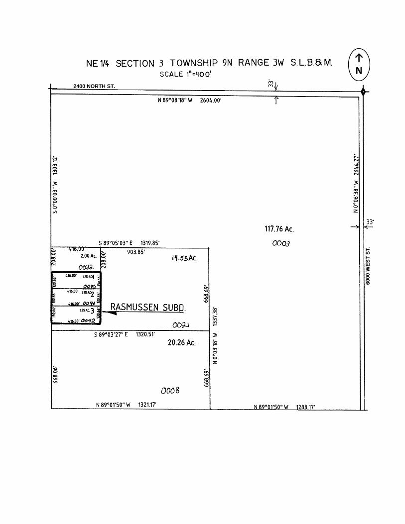
Draw the following legal descriptions based on Section Township and Range. Parcel 1 Part of the Northeast quarter of Section 03 Township 09 North Range 03 West Salt Lake Base and Meridian. Beginning at a point located 33.00 feet South from the Northwest corner of the said Northeast quarter. Running thence South 208 feet along the west line of said Northeast quarter, thence South 89°08’11” East 274 feet, thence North 208 feet to the south line of 2400 North street, thence North 89°08’11” West 274 feet to the point of beginning.
Parcel 2 Beginning at a point 183 feet South 89°53’22” West from the Southeast corner of the Northeast quarter of Section 3 Township 9 North Range 3 West Salt Lake Base and Meridian. Running thence North 00°06’38” West 300.00 feet, thence North 89°53’22” East 150.00 feet to a point on the West right of way line of 6000 West Street, thence along said right of way line South 00°06’38” East 300 feet, thence South 89°53’22”West 150.00 feet to the point of beginning. Parcel 3 Beginning at a point 492.72 feet South (495.72 of record) along the section line from the North quarter corner of Section 3 Township 9 North Range 3 West Salt Lake Base and Meridian. Thence North 164 feet, thence East 207 feet, thence South 90 feet, thence West 76 feet, thence South 74 feet, thence West 131 feet to the point of beginning. Parcel 4 Part of the Northeast quarter of Section 03 Township 09 North Range 03 West Salt Lake Base and Meridian. Beginning at a fence post located 492.72 feet South (495.72 by record) along the section line and South 89°31’19” East 33 feet from the Northwest corner of the Northeast quarter of said section. Running thence along a fence line the following four courses. (1) South 89°31’19” East 98.00 feet (East by record), (2) North 74 feet, (3) South 89°31’19” East 76 feet (East by record), (4) North 90 feet, Thence South 89°31’19” East 390.67 feet, thence South 03°39’12” West 159.77 feet, thence South 89°06’07” West 173.28 feet, thence South 00°43’44” East 173.62 feet, thence North 89°16’22” West 383.46 feet, thence North 171.61 feet to the point of beginning.
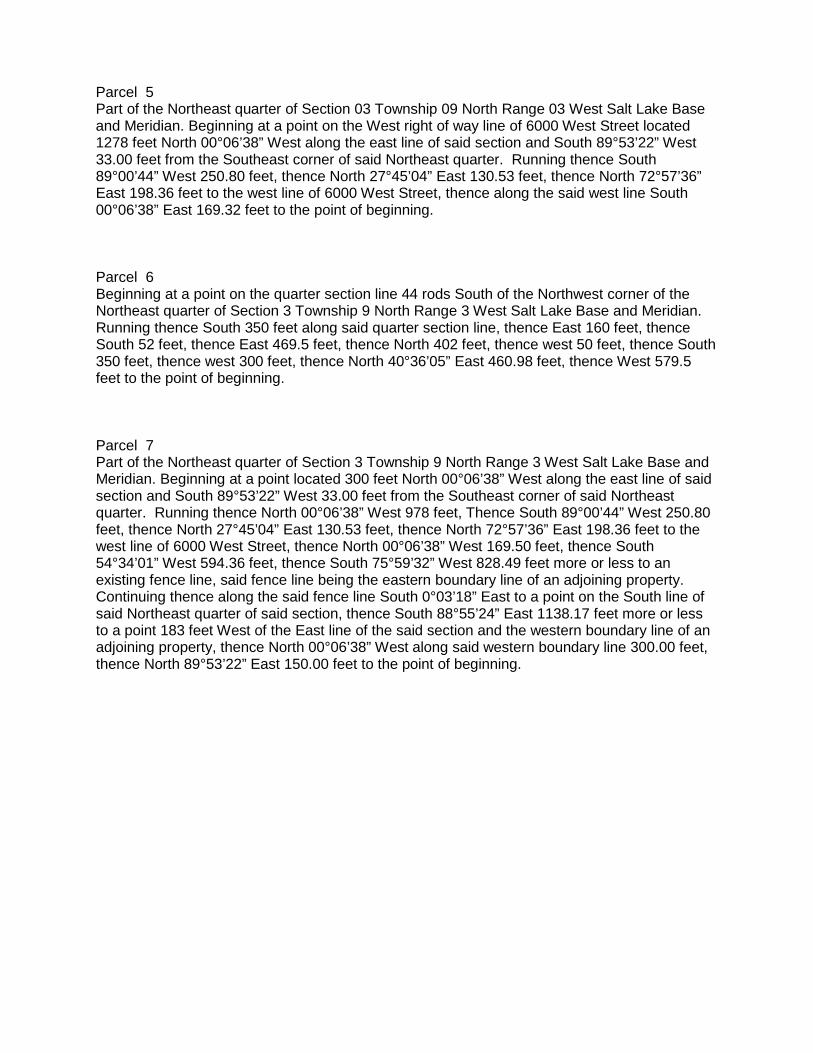
Parcel 5 Part of the Northeast quarter of Section 03 Township 09 North Range 03 West Salt Lake Base and Meridian. Beginning at a point on the West right of way line of 6000 West Street located 1278 feet North 00°06’38” West along the east line of said section and South 89°53’22” West 33.00 feet from the Southeast corner of said Northeast quarter. Running thence South 89°00’44” West 250.80 feet, thence North 27°45’04” East 130.53 feet, thence North 72°57’36” East 198.36 feet to the west line of 6000 West Street, thence along the said west line South 00°06’38” East 169.32 feet to the point of beginning. Parcel 6 Beginning at a point on the quarter section line 44 rods South of the Northwest corner of the Northeast quarter of Section 3 Township 9 North Range 3 West Salt Lake Base and Meridian. Running thence South 350 feet along said quarter section line, thence East 160 feet, thence South 52 feet, thence East 469.5 feet, thence North 402 feet, thence west 50 feet, thence South 350 feet, thence west 300 feet, thence North 40°36’05” East 460.98 feet, thence West 579.5 feet to the point of beginning. Parcel 7 Part of the Northeast quarter of Section 3 Township 9 North Range 3 West Salt Lake Base and Meridian. Beginning at a point located 300 feet North 00°06’38” West along the east line of said section and South 89°53’22” West 33.00 feet from the Southeast corner of said Northeast quarter. Running thence North 00°06’38” West 978 feet, Thence South 89°00’44” West 250.80 feet, thence North 27°45’04” East 130.53 feet, thence North 72°57’36” East 198.36 feet to the west line of 6000 West Street, thence North 00°06’38” West 169.50 feet, thence South 54°34’01” West 594.36 feet, thence South 75°59’32” West 828.49 feet more or less to an existing fence line, said fence line being the eastern boundary line of an adjoining property. Continuing thence along the said fence line South 0°03’18” East to a point on the South line of said Northeast quarter of said section, thence South 88°55’24” East 1138.17 feet more or less to a point 183 feet West of the East line of the said section and the western boundary line of an adjoining property, thence North 00°06’38” West along said western boundary line 300.00 feet, thence North 89°53’22” East 150.00 feet to the point of beginning.
↑ N
2400 NORTH ST.
6000
WES
T ST
.

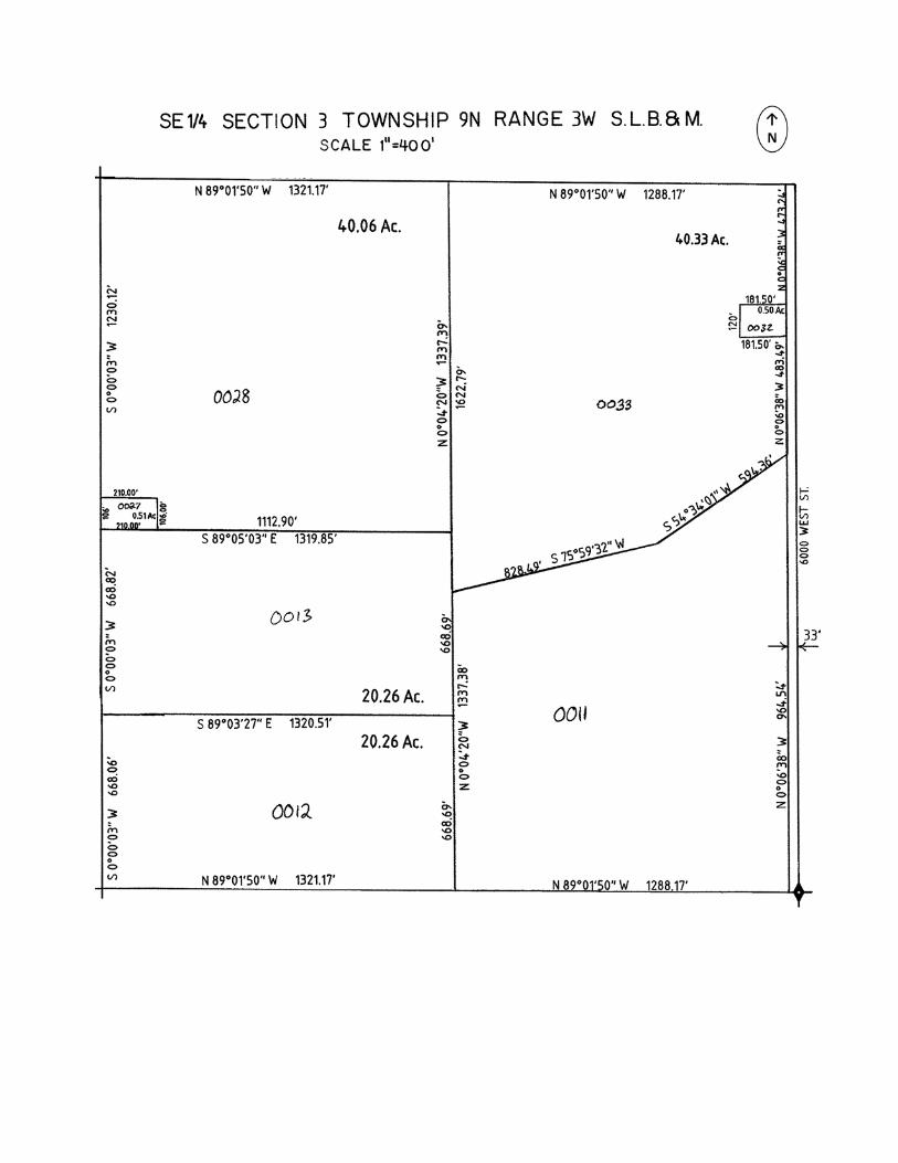
Write a legal description for the following parcels in the Southeast quarter of Section 3 Township 9 North Range 3 West: Parcel # 0013 Parcel # 0028 Parcel # 0033
Chapter 7 Homework – GIS Matching Definitions
1. ______ Traverse
2. ______ GIS
3. ______ COGO
4. ______ GPS
5. ______ PLSS
True or False
6. T F Drafting parcels with GIS uses all of the same six principals as drafting descriptions by hand, but the methods for completing them are different.
7. T F GIS parcel data always replaces a recorded document’s legal description and any survey data.
8. T F In GIS drawing a curve is much more difficult while using the traverse tool from the COGO toolbar.
A - A method for calculating coordinate points from surveyed bearings, distances, and angles.
G - A way of subdividing and describing land in the United States by a rectangular system of Section Township and Range surveys called the public land survey system.
C - To move along the course of a legal description in order to define or trace a property boundary.
D - A complex system of constellation satellites orbiting the Earth that can determine the location of a receiver on the ground.
H - A computer system that integrates hardware, software, and data for capturing, managing, analyzing, and displaying all forms of geographically referenced information.
B - Line work and line weight are two important elements used on a hand drawn cadastral maps to denote important features.
E - A set of numbers which describe the distance north (or south) and east (or west) from a monument or reference point.
F - The art of representing records on a plane surface such as paper, linen or mylar with aid of instruments.

Draw the following seven parcel descriptions using the digital drafting tools that are available to you in your county.
NOTE: If your county uses ArcGIS there is data available for download to help complete the exercise.
Parcel 1 Part of Lots 12 & 13 Block 03 Plat B Willard City Survey. Beginning at a point located South
00°18’32” East 53 Feet from the Northwest corner of said Lot 13. Running thence South
89°41’19” East 164 Feet, Thence North 00°18’32” West 53 Feet, Thence South 89°41’19” East
100 Feet to the Northeast corner of Lot 13, Thence South 00°18’32” East 153 Feet, Thence
North 89°41’19” West 264 Feet to the west line of Lot 12, Thence North 00°18’32” West 100
Feet to the point of beginning.
Parcel 2 The West half of Lot 05 and the South 1 rod of Lot 4 Block 03 Plat B Willard City Survey.
Parcel 3 Beginning at a point 492.72 feet South (495.72 of record) along the section line from the North
quarter corner of Section 3 Township 9 North Range 3 West Salt Lake Base and Meridian.
Thence North 164 feet, thence East 207 feet, thence South 90 feet, thence West 76 feet, thence
South 74 feet, thence West 131 feet to the point of beginning.
Parcel 4 Part of the Northeast quarter of Section 03 Township 09 North Range 03 West Salt Lake Base
and Meridian. Beginning at a fence post located 492.72 feet South (495.72 by record) along the
section line and South 89°31’19” East 33 feet from the Northwest corner of the Northeast
quarter of said section. Running thence along a fence line the following four courses. (1) South
89°31’19” East 98.00 feet (East by record), (2) North 74 feet, (3) South 89°31’19” East 76 feet
(East by record), (4) North 90 feet, Thence South 89°31’19” East 390.67 feet, thence South
03°39’12” West 159.77 feet, thence South 89°06’07” West 173.28 feet, thence South 00°43’44”
East 173.62 feet, thence North 89°16’22” West 383.46 feet, thence North 171.61 feet to the
point of beginning.

Parcel 5 Beginning at a point on the quarter section line 44 rods South of the Northwest corner of the
Northeast quarter of Section 3 Township 9 North Range 3 West Salt Lake Base and Meridian.
Running thence South 350 feet along said quarter section line, thence East 160 feet, thence
South 52 feet, thence East 469.5 feet, thence North 402 feet, thence west 50 feet, thence South
350 feet, thence west 300 feet, thence North 40°36’05” East 460.98 feet, thence West 579.5
feet to the point of beginning.
Parcel 6 Part of the NW quarter of Section 3, Township 9 North, Range 3 West, Salt Lake Base and
Meridian. Beginning at a point South 10° East 106.37 feet and North 80° East 72.48 feet from
the Northwest corner of said section. Running thence North 63°44'45" East 75 feet; thence
South 26°15'15" East 120.87 feet; thence South 70° West 75.45 feet; thence North 26°15'15"
West 112.65 feet' to the point of beginning.
In ArcGIS, rotate the drawing of parcel 6 to match the nearby section line and existing parcel.
Parcel 7 Beginning at point North 0°13’ East 195.63 feet along the section line from the Southwest corner
of Section 34, Township 10 North, Range 3 West, Salt Lake Base and Meridian. Running
thence North 0°13' East 362.81feet; thence North 75°56'26" East 140.33 feet; thence to the left
260 feet along the arc of a curve whose radius is 356.37 feet whose chord bears South
34°57'37" East 254.22 feet; thence South 29°18'36" West 43.50 feet; thence to the right 317.16
feet along the arc of a curve whose radius is 295.05 feet and whose chord bears South
60°06'18" West 302.11 feet to the point of beginning.