chapter 1: purpose and need - washington, d.c. · chapter 1: purpose and need 1.1. ... exposed tree...
TRANSCRIPT

Rock Creek Park Multi-Use Trail Rehabilitation Purpose and Need
Page 1
CHAPTER 1: PURPOSE AND NEED
1.1. INTRODUCTION
The District Department of Transportation (DDOT) in conjunction with the Federal Highway Administration (FHWA), the National Park Service (NPS), and with the cooperation of the National Capital Planning Commission (NCPC) has prepared an Environmental Assessment (EA) to assess the potential effects of various alternatives for the rehabilitation of the Rock Creek Park multi-use trail in Washington, DC. Rock Creek Park is a 2,896 acre park under the jurisdiction of the NPS. The trail is in northwest Washington, DC and extends from Wise Road, NW to Military Road, NW, then from Broad Branch Road south to the Lincoln Memorial Circle. Implementation of the proposed action would be administered by DDOT and funded by FHWA.
The proposed action includes the rehabilitation of a 3.7-mile section of the Rock Creek Park multi-use trail from Broad Branch Road to P Street, NW; a 4,300-foot (0.8 mile) section of the Piney Branch Parkway trail from Beach Drive to Arkansas Avenue, NW; a 1,929-foot (0.4 mile) section of the Rose Park trail from P Street, NW to M Street, NW; a 363-foot ramp connecting the Rose Park trail to P Street, NW; and a 1,247-foot section (0.2 mile) of social trail from Broad Branch Road to Peirce Mill (referred to as the Peirce Mill trail spur). The proposed action includes resurfacing, trail widening where environmentally feasible, modifications to the trail alignments and road crossings, directional and interpretive signage, and connections to and from the trails to other pedestrian and bicycle facilities. Rock Creek Park and the Rock Creek and Potomac Parkway are under the jurisdiction of the NPS, but implementation of the proposed action will be administered by DDOT and funded by FHWA. The majority of the proposed improvements are located on NPS land, with some improvements located within District of Columbia right-of-way. A section of the trail passes through National Zoological Park property. The proposed action does not involve any transfer of ownership or change of jurisdiction of the trail or the land within the project area. Ownership of the trail and land within the project area will remain with the current owners.
DDOT in conjunction with the FHWA and NPS prepared an EA, which identified the agencies’ Preferred Alternative and was released for agency and public review in November 2011. The public comment period ran from December 2, 2011 to January 13, 2012. A public hearing was held on December 14, 2011. The EA evaluated the potential environmental impacts of the No Action Alternative and two Action Alternatives, in accordance with the National Environmental Policy Act of 1969 (NEPA), Section 106 of the National Historic Preservation Act (NHPA), NPS Director’s Order #12: Conservation Planning, Environmental Impacts Analysis and Decision-Making (NPS 2001), FHWA Technical Advisory (T6640.8a), and other applicable laws, regulations, and policies. Section 106 requires federal agencies to take into account the effects of their undertakings on historic properties. In accordance with the regulations implementing Section 106 of the NHPA, coordination has been initiated with the DC Historic Preservation Office (HPO) and Advisory Council on Historic Preservation (ACHP). This Final EA has been prepared to address agency and public comments received.

Purpose and Need Rock Creek Park Multi-Use Trail Rehabilitation
Page 2
1.2. PURPOSE OF AND NEED FOR ACTION
The NPS is in charge of preserving the natural and cultural resources of Rock Creek Park while providing a high quality visitor experience. The purpose of this action is to improve the overall condition and connectivity of the Rock Creek Park multi-use trail system in order to enhance visitor use and experience within Rock Creek Park. The proposed action would result in:
• improved visitor safety and experience and protection of park resources; • improved access to the Rock Creek Park multi-use trail system from other pedestrian and bicycle
facilities, as well as the surrounding neighborhoods; and • more effective drainage and erosion control, thereby reducing trail maintenance.
The action is needed to improve safety caused by the continued deterioration of the trail, resulting in heaving or cracking of the pavement, exposed tree roots, and water ponding during and after storm events. Connectivity of the trail with surrounding neighborhoods, street crossings, existing sightlines, grade changes, curves and approaches may not meet current guidelines for multi-use trails. Additionally, narrow trail widths in some areas may impede the ability of trail users and groups (pedestrians, bicyclists, runners, those enjoying nature, etc.) to safely pass one another, generating a potential for user conflicts or accidents.
Another need for the action is to prevent soil compaction, vegetation damage, and soil erosion caused by social trails. In some areas, visitors leave the trails to take shortcuts, or maneuver around other users or trail sections in need of repair. The creation of social trails at these locations has resulted in areas of soil compaction and vegetation damage. Loss of vegetation may contribute to soil erosion.
The extensive Rock Creek Park trail system is enjoyed by a large number of visitors. However, currently there are connectivity gaps and/or unpaved areas of the existing park trail system. Furthermore, due to the popularity of the park and large number of visitors, there is currently a need for additional connectivity to and from the larger pedestrian and bicycle systems in the surrounding neighborhoods such as sidewalks, bicycle routes, and other trails.
Another need for the project is visitor use and experience, and the need for NPS to continue to support the diverse user groups who enjoy the trails. Heaving or cracked pavement, exposed tree roots, and water ponding issues can be both unsightly and challenging to circumvent. Additionally, potential conflicts may occur among trail user groups – bicyclists, runners, those enjoying nature, pedestrians, etc. – in areas that are difficult to navigate due to short sight lines, narrow widths, or alignment deviations. Additionally, there are currently unrealized opportunities for interpretive programs along the trail, such as signage and ranger walks, that could enhance visitor use and experience by further highlighting the many environmental and cultural resources within the park.
1.3. PROJECT OBJECTIVES
Project objectives are defined in terms of “what must be achieved to a large degree for the action to be considered a success,” and represent more specific statements of purpose and need (NPS 2001). All alternatives selected for detailed analysis must meet all objectives to a large degree and must resolve the purpose of and need for action. The following objectives were identified by the planning team for this project:
Rock Creek Park Multi-Use Trail Rehabilitation Purpose and Need
Page 3
1. Improve trail safety. 2. Provide improved access to the Rock Creek Park multi-use trail from surrounding communities
and the larger bicycle and pedestrian network. 3. Preserve the integrity of Rock Creek Park and its resources. 4. Maximize the distance between the trail and Rock Creek to the extent feasible. 5. Minimize ground disturbance from new trail construction. 6. Minimize the loss of trees and vegetation. 7. Reuse and/or interpret historic trail alignments to the extent feasible.
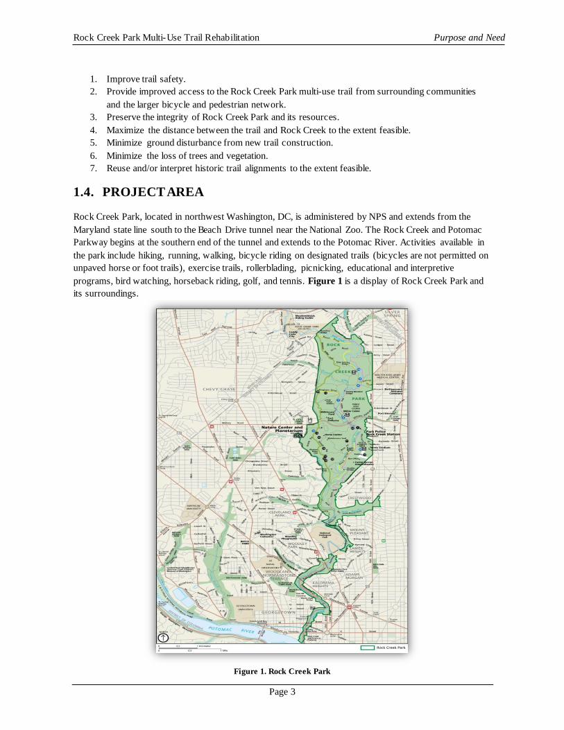
1.4. PROJECT AREA
Rock Creek Park, located in northwest Washington, DC, is administered by NPS and extends from the Maryland state line south to the Beach Drive tunnel near the National Zoo. The Rock Creek and Potomac Parkway begins at the southern end of the tunnel and extends to the Potomac River. Activities available in the park include hiking, running, walking, bicycle riding on designated trails (bicycles are not permitted on unpaved horse or foot trails), exercise trails, rollerblading, picnicking, educational and interpretive programs, bird watching, horseback riding, golf, and tennis. Figure 1 is a display of Rock Creek Park and its surroundings.
Figure 1. Rock Creek Park

Purpose and Need Rock Creek Park Multi-Use Trail Rehabilitation
Page 4
The area of Rock Creek Park and the Rock Creek and Potomac Parkway under consideration in this EA consists of a 3.7-mile section of the Rock Creek Park multi-use trail and connecting pathways. Figure 2 displays the project area.
Figure 2. Project Area
The 3.7-mile section of the Rock Creek Park multi-use trail from the Broad Branch/Grove 2 North parking area to P Street, NW is currently paved with asphalt. From the Broad Branch/Grove 2 North parking area to Piney Branch, the trail is mainly 10 feet in width, with some narrower sections. From Piney Branch Parkway to P Street, NW, the trail is mainly eight feet wide, with some narrower sections. This 3.7-mile

Rock Creek Park Multi-Use Trail Rehabilitation Purpose and Need
Page 5
section of the trail is over 20 years old and has shown deterioration such as erosion, pavement ruts, drainage issues, exposed tree roots and other wear that has made it less safe and less attractive for trail users (Figure 3a and 3b). In addition, current trail widths, sightlines at curves and approaches, and grade changes may not meet current guidelines for multi-use trails. (However, as discussed later in this document, there are instances where environmental constraints impact the ability to widen the trail.) Social trails have been created by users throughout the project area, resulting in areas of soil compaction and vegetation damage (Figure 3c).
Figure 3. Existing Conditions: Rock Creek Park Multi-Use Trail and Piney Branch Parkway Trail
The study area also includes the following sections, directly adjacent to the Rock Creek Park multi-use trail: a 4,300-foot (0.8 mile) section of the Piney Branch Parkway trail from Beach Drive to Arkansas Avenue, NW; a 1,929-foot (0.4 mile) section of the Rose Park trail from P Street, NW to M Street, NW; a 363-foot ramp connecting the Rose Park trail to P Street, NW; and a 1,247-foot (0.2 mile) social trail along Rock Creek from Broad Branch Road to Peirce Mill (i.e., the Peirce Mill Spur). Trail users have created social trails in these process as means for direct connection to the Rock Creek Park multi-use trail from the surrounding community. Improvements to these sections will provide safe and improved connectivity and access to the Rock Creek Park multi-use trail.
The majority of the Piney Branch Parkway trail in the project area is unpaved. Social trails from the Rock Creek Park multi-use trail and Porter Street, NW to the west, and from Arkansas Avenue, NW and 16th Street, NW to the east, connect to a short section of paved trail along Piney Branch Parkway, just east of Park Road, NW. The paved portion abuts Piney Branch Parkway and is not separated from vehicular traffic by any safety barriers (Figure 3d).

Purpose and Need Rock Creek Park Multi-Use Trail Rehabilitation
Page 6
Rose Park is in the Georgetown neighborhood, and is bordered by P Street, NW to the north; M Street, NW to the south; 26th and 27th Streets to the west; and the Rock Creek and Potomac Parkway to the east. The park includes three tennis courts, a basketball court, a baseball diamond, and two playground areas, which are administered by the DC Department of Parks and Recreation, and a trail which is administered by NPS. The Rose Park trail parallels the Rock Creek and Potomac Parkway trail, located to the east and down an approximately 50-foot embankment. The 1,929-foot (0.4 mile) section of the Rose Park trail and its connection to P Street included in this project runs from P Street, NW to M Street, NW. The paved Rose Park trail is mainly five feet in width, with a short section that is currently six feet in width (Figure 4a).
At the north end of Rose Park, a social trail connects to the Rock Creek & Potomac Parkway trail along the entrance ramp that connects P Street, NW to the Rock Creek and Potomac Parkway. At the southern end of the park, a social trail breaks off the main trail and connects to M Street, NW (Figure 4b). A brick pathway meanders through sections of the park and also connects to M Street, NW.
Peirce Mill is a 19th century gristmill that is maintained by the NPS as a historical site. The site is located on Tilden Street, NW and is positioned along the west banks of Rock Creek. A ten-year project to restore the functionality of Peirce Mill was completed in 2011. From Broad Branch Road to Peirce Mill, there is a 1,247-foot social trail. The social trail lies between the Rock Creek Park multi-use trail and Rock Creek.
Figure 4. Existing Conditions: Rose Park Trail and Social Trail to M Street, NW
1.5. PROJECT BACKGROUND
Based on public comments received in 2006, a project to prepare an EA and Assessment of Effects was initiated by FHWA, NPS, and DDOT in 2009. The purpose and need for the project was identified by DDOT and the NPS. Implementation of the proposed action would be administered by DDOT, through FHWA funding. Public scoping for the proposed action was originally initiated by NPS in 2006, at which time a meeting was held to solicit feedback regarding the rehabilitation of the trail. During this time an agency and public scoping period was held to gather input on the scope of the EA and the proposed action. Prior to the release of the EA, the project was put on hold. Funding again became available in November 2010, at which time the Rock Creek Park Multi-Use Trail Rehabilitation was reinitiated and the planning process for this EA commenced.

Rock Creek Park Multi-Use Trail Rehabilitation Purpose and Need
Page 7
1.5.1. ROCK CREEK PARK AND THE ROCK CREEK AND POTOMAC PARKWAY
Rock Creek Park was established on September 27, 1890 as one of the first national parks. It was set aside for the people of the United States as a unique area of natural beauty and to preserve significant natural, historic and archeological resources (Pub. L. 51-297, 26 Statute 482). Over the years, as the Washington metropolitan area has become more urban, the need for undeveloped green spaces like Rock Creek Park has increased. The Rock Creek Park multi-use trail has served as the major access link for visitors who wish to experience the natural and cultural beauty of the park. As noted in the Rock Creek Park and the Rock Creek and Potomac Parkway General Management Plan (NPS 2007), the significance of the park includes the following factors:
• Rock Creek Park is one of the oldest and largest naturally managed urban parks in the United States.
• The areas administered by Rock Creek Park, including Rock Creek and Potomac Parkway, contain nearly 3,000 acres and provide valuable plant and wildlife habitat in a heavily urbanized area.
• Rock Creek Park encompasses a rugged stream valley of exceptional scenic beauty, including forested, natural landscapes and intimate natural details that provide a contrast to the surrounding cityscape of Washington, DC.
• Rock Creek Park’s forests and open spaces help define the character of the nation’s capital. • Rock Creek valley was important in the early history of the region and in the development of the
nation’s capital, and the park’s cultural resources are among the few tangible remains of the area’s past.
• Rock Creek Park is a historic landscape, incorporating early 20th century picturesque and rustic features that were designed to enhance the visitors’ experience in the naturalistic park scenery.
• Rock Creek Park serves as an oasis for urban dwellers, offering a respite from the bustle of the city.
The Rock Creek and Potomac Parkway was established in 1913 by the Public Buildings Act. The parkway was created to prevent pollution and obstruction of Rock Creek and to provide a connector between Potomac Park and the Smithsonian National Zoological Park and Rock Creek Park. The parkway was completed in 1936 and has served as a scenic roadway in and out of Washington, DC. Almost since its opening, the parkway has become a preferred commuter route for many residents of northwest Washington, DC and Montgomery County, Maryland.
The Rock Creek and Potomac Parkway is one of the earliest parkways in the nation, the oldest in the metropolitan region, and the first to be federally funded (Congressional legislation, 1913). It is representative of early parkway design in the United States. Although it was initially intended for carriages, horseback riders, pedestrians, and the occasional recreational automobile, early design changes reflected increased automobile traffic. Accordingly, the Rock Creek and Potomac Parkway reflects issues that affected the evolution of American Parkway design. The prolonged design process ensured that the parkway was a collaborative work of several landscape architects, yet the park reflects the guiding vision of Frederick Law Olmsted, Jr. (HABS, 1992). Initially, he proffered the concept as the landscape architect member of the Senate Park Commission.

Purpose and Need Rock Creek Park Multi-Use Trail Rehabilitation
Page 8
1.6. APPLICABLE FEDERAL LAWS AND REGULATIONS
The following are laws, regulations, and management plans applicable to the proposed action that govern the federal agencies involved in this NEPA analysis.
1.6.1. NATIONAL ENVIRONMENTAL POLICY ACT, 1969, AS AMENDED
The NEPA was passed by Congress in 1969 and established the nation’s environmental policies with the goal of achieving productive harmony between human beings and the physical environment for present and future generations. To implement this goal, NEPA required every federal agency to prepare an in-depth study of the impacts of “major federal actions having a significant effect on the environment” and alternatives to those actions. It also required that each agency make that information an integral part of its decisions. NEPA also requires that federal agencies make a diligent effort to involve the interested members of the public before they make decisions affecting the environment. NEPA is implemented through regulations of the Council on Environmental Quality (CEQ), effective 1978 (40 CFR 1500 – 1508). The NPS has adopted procedures to comply with NEPA and the CEQ regulations, as found in DO-12: Conservation Planning, Environmental Impact Analysis, and Decision-making (NPS 2001), and its accompanying handbook.
1.6.2. ROCK CREEK PARK ENABLING LEGISLATION OF 1890
The Rock Creek Park Authorization was signed into law on September 27, 1890 and states that regulations are to be established which “provide for the preservation from injury or spoliation of all timber, animals, or curiosities within said park, and their retention in their natural condition, as nearly as possible.” This enabling legislation also directed the Engineering Commissioner of the District of Columbia and the Chief of Engineers of the United States Army to “to lay out and prepare roadways and bridle paths, to be used for driving and for horseback riding, respectively, and footways for pedestrians” (NPS 2010).
1.6.3. NATIONAL HISTORIC PRESERVATION ACT OF 1966, AS AMENDED – SECTION 106
The NHPA of 1966, as amended through 2006, protects districts, sites, buildings, structures, and objects significant in American history, architecture, archeology, engineering, and culture (NHPA 2006). The Act established affirmative responsibilities of federal agencies to preserve historic and prehistoric resources. Effects on properties that are listed on or are eligible for the National Register of Historic Places (NRHP) must be taken into account in planning and operations.
Section 106 of the NHPA (16 U.S.C. 470 et seq.) requires federal agencies to take into account the effects of their undertakings on historic properties either listed on or eligible to be listed on the National Register. The historic preservation review process required by Section 106 is outlined in regulations (36 CFR Part 800, Protecting Historic Properties) issued by Advisory Council on Historic Preservation (ACHP), an independent federal agency established by the NHPA in 1966 to promote the preservation, enhancement, and productive use of our nation's historic resources. The goal of the Section 106 review process is to seek ways to avoid, minimize, or mitigate any adverse effects to historic properties (ACHP 2009).

Rock Creek Park Multi-Use Trail Rehabilitation Purpose and Need
Page 9
1.6.4. ENDANGERED SPECIES ACT OF 1973 (16 U.S.C. 1531-1544, 87 STAT. 884), AS AMENDED
This act requires all federal agencies to consult with the Secretary of the Interior on all projects and proposals having potential impact on federally endangered and threatened plants and animals. NPS policy also requires examination of the impacts on federal candidate species, as well as state-listed threatened, endangered, candidate, rare, declining, and sensitive species. Section 7 of the Endangered Species Act requires federal agencies, through consultation with U.S. Fish & Wildlife Service, to insure that any action authorized, funded or carried out by them is not likely to jeopardize the continued existence of listed species or modify their critical habitat.
1.6.5. HISTORIC SITES ACT OF 1935
The Historic Sites Act of 1935 is the second major national historic preservation legislation and declares as national policy the preservation for public use of historic sites, buildings, objects, and properties of national significance. It authorizes the Secretaries of the Interior and NPS to restore, reconstruct, rehabilitate, preserve, and maintain historic or prehistoric sites, buildings, objects, and properties of national historical or archeological significance (PL 74-292).
1.6.6. ORGANIC ACT OF 1916 (NPS)
The Organic Act of 1916 (Organic Act) directs the U.S. Department of the Interior and the NPS to manage units in order “to conserve the scenery and the natural and historic objects and wildlife therein and to provide for the enjoyment of the same in such a manner and by such a means as will leave them unimpaired for the enjoyment of future generations” (16 USC § 1).
Although the NPS seeks to avoid or to minimize adverse impacts on park resources and values, the NPS has discretion to allow impacts on park resources and values when necessary and appropriate to fulfill the purposes of a park (NPS 2006). While some actions and activities cause impacts, the NPS cannot allow an adverse impact that would constitute impairment of the affected resources and values. The Organic Act prohibits actions that permanently impair park resources unless a law directly and specifically allows for the acts (16 USC 1a-1). An action constitutes an impairment when its impacts “harm the integrity of park resources or values, including the opportunities that otherwise would be present for the enjoyment of those resources or values” (NPS 2006). To determine impairment, the NPS must evaluate “the particular resources and values that would be affected; the severity, duration, and timing of the impact; the direct and indirect effects of the impact; and the cumulative effects of the impact in question and other impacts” (NPS 2006).
1.6.7. NATIONAL PARKS OMNIBUS MANAGEMENT ACT OF 1998
The National Parks Omnibus Management Act (NPOMA) (16 USC 5901 et seq.) is fundamental to NPS park management decisions. The Omnibus Management Act provides direction for connecting resource management decisions to the analysis of impacts, using appropriate technical and scientific information. The Act also recognizes that such data may not be readily available; therefore, it provides options for resource impact analysis should this be the case. NPOMA directs the NPS to obtain scientific and technical information for analysis. The NPS handbook for DO-12 states that if “such information cannot be obtained due to excessive cost or technical impossibility, the proposed alternative for decision will be modified to eliminate the action causing the unknown or uncertain impact, or other alternatives will be selected” (NPS 2001).

Purpose and Need Rock Creek Park Multi-Use Trail Rehabilitation
Page 10
1.6.8. AMERICANS WITH DISABILITIES AND ARCHITECTURAL BARRIERS ACT GUIDELINES
Pursuant to the Americans with Disabilities Act of 1990 (ADA) and the Architectural Barriers Act of 1968 (ABA), all public buildings, structures, and facilities must comply with specific requirements related to architectural standards, policies, practices, and procedures that accommodate people with hearing, vision, or other disability; and other access requirements. Public facilities and places must remove barriers in existing buildings and landscapes, as necessary and where appropriate. The NPS must comply with the Architectural Barriers Act Accessibility Standard (ABAAS) as well as ADA standards for this project (NPS 2000).
1.6.9. REDWOOD NATIONAL PARK ACT OF 1978, AS AMENDED
All national park system units are to be managed and protected as parks, whether established as a recreation area, historic site, or any other designation. The Redwood National Park Act of 1978 amended the NPS General Authorities Act of 1970 and states that the NPS must conduct its actions in a manner that will ensure no “derogation of the values and purposes for which these various areas have been established, except as may have been or shall be directly and specifically provided by Congress” (16 USC 1a).
1.6.10. THE CLEAN WATER ACT (1972, AS AMENDED IN 1977 AND 1987)
The Clean Water Act (CWA) was enacted to provide the basic structure for regulating pollutant discharges and ensuring that surface waters meet standards that allow for recreational and sporting activities. As authorized by the CWA, the National Pollutant Discharge Elimination System (NPDES) permit program is organized within the Environmental Protection Agency (USEPA) and controls water pollution by regulating point sources that discharge pollutants into waters of the United States. Any federal, industrial, or municipal facilities must obtain NPDES permits if their discharges go directly to surface waters (USEPA 2009).
1.7. EXECUTIVE ORDERS AND DIRECTOR’S ORDERS
1.7.1. EXECUTIVE ORDER 11988 FLOODPLAIN MANAGEMENT
Executive Order (EO) 11988 (Floodplain Management) requires federal agencies to avoid direct or indirect support of development within the 100-year floodplain whenever there is a practicable alternative. A floodplain is defined as the lowland and relatively flat areas adjoining inland and coastal waters, including flood-prone areas of offshore islands, and including, at a minimum, that area subject to a one percent or greater chance of flooding in any given year (USEPA 2011b).
1.7.2. DIRECTOR’S ORDER 77-2: FLOODPLAIN MANAGEMENT
Director’s Order 77-2 applies to all proposed NPS actions that could adversely affect the natural resources and functions of floodplains or increase flood risks. This includes those proposed actions that are functionally dependent upon locations in proximity to the water and for which non-floodplain sites are not practicable alternatives (NPS 2003).

Rock Creek Park Multi-Use Trail Rehabilitation Purpose and Need
Page 11
1.7.3. DIRECTOR’S ORDER 28: CULTURAL RESOURCE MANAGEMENT
DO-28 directs the NPS to protect and manage cultural resources in its custody through effective research, planning, and stewardship and in accordance with the policies and principles contained in NPS Management Policies (NPS 2006). This order also directs the NPS to comply with the substantive and procedural requirements described in the Secretary of the Interior’s Standards and Guidelines for Archeology and Historic Preservation, the Secretary of the Interior’s Standards for the Treatment of Historic Properties with Guidelines for Treatment of Cultural Landscapes; and the Secretary of the Interior’s Standards for the Treatment of Historic Properties with Guidelines for Preserving, Rehabilitating, Restoring and Reconstructing Historic Building (NPS 1998).
The NPS will comply with the 2008 Service-wide Programmatic Agreement with the ACHP and the National Conference of State Historic Preservation Officers, the purpose of which was to establish a streamlined process for compliance with Section 106 of the NHPA (ACHP 2008).
1.8. NPS MANAGEMENT POLICIES
The NPS Management Policies (NPS 2006) is the basic NPS-wide policy document, adherence to which is mandatory unless specifically waived or modified by the NPS director or certain departmental officials, including the U.S. Secretary of Interior. Actions under this EA are in part guided by these management policies.
• Section 4.1.3: Evaluating Impacts on Natural Resources • Section 4.6.3: Water Quality • Section 4.6.4: Floodplains • Section 4.8.2.4: Soil Resource Management • Section 5.3.1: Protection and Preservation of Cultural Resources • Section 8.2.2: Recreational Activities • Section 8.2.4: Accessibility for Persons with Disabilities • Section 8.2.5.2: Visitor Safety and Emergency Response • Section 8.2.5.5: Public Health Program • Section 9.1.3.2: Revegetation and Landscaping • Section 9.1.4: Maintenance • Section 9.2.2: Trails and Walks
1.8.1. ROCK CREEK PARK AND THE ROCK CREEK AND POTOMAC PARKWAY GENERAL
MANAGEMENT PLAN, 2007
The NPS completed the Final Rock Creek Park and the Rock Creek and Potomac Parkway General Management Plan (Rock Creek Park GMP) in November 2005. The Rock Creek Park GMP was approved and a Record of Decision was executed in June of 2007. Four alternatives were presented in the FEIS and Alternative A was chosen as the preferred alternative. Alternative A called for improvement of visitor safety, better traffic volume and speed controls, enhanced interpretation and education opportunities, and improved use of park resources. The Rock Creek Park GMP is the first comprehensive management plan for Rock Creek Park and provides a basis for decision-making for more specific future plans for Rock Creek Park. This project is consistent with the Rock Creek Park GMP as Alternative A calls for the upgrade and rehabilitation of deteriorating sections of the Rock Creek Park multi-use trail (NPS 2007).

Purpose and Need Rock Creek Park Multi-Use Trail Rehabilitation
Page 12
1.9. LOCAL PLANS AND POLICIES
1.9.1. NATIONAL CAPITAL PLANNING ACT
The National Capital Planning Act (Act) establishes the National Capital Planning Commission (NCPC) as the central planning agency in the Washington, DC region. The purpose of the agency is to coordinate the developmental activities of the Federal and District governments so that the activities conform to general objectives. The Act outlines the functions of the NCPC, which include development of a Comprehensive Plan, review of Federal and District proposed projects, review of District zoning amendments, and review of Federal and District Capital Improvements Programs (40 USC §§8701 et seq.).
1.9.2. THE 2006 COMPREHENSIVE PLAN FOR THE NATIONAL CAPITAL REGION: FEDERAL ELEMENTS
Section 4(a) of the National Capital Planning Act requires that NCPC develop and implement a “comprehensive, consistent, and coordinated plan for the National Capital.” (NCPC 2004) The Plan emphasizes three principles: accommodating Federal and National Capital activities, reinforcing “smart growth” and sustainable development planning principles, and supporting local and regional planning and development objectives.
1.9.3. THE 2006 COMPREHENSIVE PLAN FOR THE NATIONAL CAPITAL REGION: DISTRICT ELEMENTS; PARKS, RECREATION, AND OPEN SPACES SECTION 1.1.2: CONSIDERATION OF FEDERAL PARKLAND
The District of Columbia will work with federal agencies to evaluate the role that federal lands play in meeting the recreational needs of District residents, particularly for regional parks and sports complexes. These federal resources are used by city residents, and therefore should be considered when assessing the need for local park improvements (DCOP 2006).
1.9.4. DISTRICT OF COLUMBIA BICYCLE MASTER PLAN
The DDOT 2005 Bicycle Master Plan includes several core goals and recommendations in order to establish a world-class bicycle transportation system in the District of Columbia. Several strategies are named to increase bicyclist safety and security while improving the connectivity and accessibility of destinations and activity centers within the District of Columbia.
Multi-use trails are specifically cited to provide a high quality walking and bicycling experience in an environment separated from traffic. These types of paths can be constructed within a roadway corridor right-of-way, in their own corridor (such as a greenway trail or rail-trail), or be a combination of both. Shared-use paths should not be used to preclude on-road bicycling but rather to supplement a system of on-road bicycle facilities for less experienced cyclists.
1.9.5. DISTRICT OF COLUMBIA PEDESTRIAN MASTER PLAN
The District of Columbia Pedestrian Master Plan (Toole Design Group, 2009) seeks to reduce the number of pedestrian/motor vehicle crashes and increase pedestrian activity by making walking a comfortable and accessible mode of travel throughout all parts of the District. The Plan also encourages improved facilities and policies to promote the benefits of walking for transportation, recreation, and health.

Rock Creek Park Multi-Use Trail Rehabilitation Purpose and Need
Page 13
1.10. SCOPING PROCESS AND PUBLIC PARTICIPATION
NEPA regulations require an “early and open process for determining the scope of issues to be addressed and for identifying the significant issues related to a proposed action.” To determine the scope of issues to be analyzed in depth in this plan, meetings were conducted with the lead agencies and the public.
Public scoping for the proposed action was originally initiated by NPS in 2006. A meeting was held on October 26, 2006 at Peirce Mill to give the public the opportunity to share ideas on the potential rehabilitation of the trail. Based on comments received during the 2006 scoping, a project to prepare an EA commenced in 2009. During this time, federal and local agencies, as well as community stakeholders, were invited to provide comments on the scope of the EA and the proposed action. Three letters were received from the public during the scoping period. A letter from Friends of Peirce Mill was received describing the restoration efforts underway at the Mill in 2009. The Friends of Rose Park and the Beall Court Condominium Association both submitted commented that the Rose Park trail should not be widened. The NCPC, DC HPO, Smithsonian Institution, and District of Columbia Office of Planning (DC OP) provided comments with recommendations for the EA. Prior to the release of the EA, the project was put on hold.
In November 2010, when funding again became available, the Rock Creek Park Multi-Use Trail Rehabilitation project was reinitiated. In addition to an agency scoping period, a public scoping period was opened January 28, 2011 through February 28, 2011. During this time, the public was invited to provide comments on the proposed action and scope of the EA, and issues and concerns regarding natural, socioeconomic, and cultural resources. Public notices were posted on the Planning, Environment and Public Comment website (PEPC), the DDOT website and Facebook pages, and advertised in The Washington Post and The Current newspapers. The project team also sent email notices or posted to listservs of Advisory Neighborhood Commissioners (ANCs), community groups, and potential stakeholders, including individuals and groups who previously expressed an interest in the project.
A public scoping meeting was held on February 23, 2011, at the National Zoo Visitor Center Auditorium, 3001 Connecticut Avenue, NW, Washington, DC. The purpose of this meeting was to solicit public input on the purpose, need, and objectives of the project, major issues, and alternatives. A total of fifty-four (54) people signed in to the meeting. The meeting was held in an open-house format, followed by an open microphone session in which attendees could sign up to speak at a microphone. Approximately six hundred (600) comments were received during the public scoping period, which took place from January 28, 2011 to February, 28, 2011. In general, the comments articulated support for the Action Alternatives. The majority of respondents favored Rock Creek Park Trail Alternative 3: Trail Resurfacing and Widening, Peirce Mill Trail Spur Option B: Eight-foot Paved Trail Spur, and Rose Park Trail Option C: Eight-foot Resurfaced Trail.
In addition to public scoping, a meeting was held on April 13, 2011 for the Friends of Rose Park to discuss the proposed project and gather information from local residents and community groups as it pertains to the trail in Rose Park.
The EA was released on December 2, 2011 and formal comments on the proposed action and the EA were accepted through January 13, 2012. Prior to the release of the EA, a notice of availability and notice of public hearing was distributed through a variety of outlets including the DDOT and the NPS Planning, Environment and Public Comment (PEPC) websites; printed notices appeared in the Legal Notice sections of the Washington Post and Current newspapers; and electronic notices were sent to the ANC and neighborhood association listservs, as well as approximately 75 individuals who had requested

Purpose and Need Rock Creek Park Multi-Use Trail Rehabilitation
Page 14
periodic updates via the project website. DDOT held a Public Hearing at the Columbia Heights Education Campus on December 14, 2011 from 6:00 p.m. to 8:00 p.m. The hearing was set up in an Open House format from 6:00 – 6:30, with public comments from 6:30 p.m. – 8:00 p.m. The purpose of the public hearing was to give interested parties the opportunity to provide formal comments on the Draft EA and Section 106 Evaluation by signing up to speak at the microphone, by speaking privately to a court reporter, or by providing written comments via comment forms, mail, or the project website. Fourteen (14) individuals attended the hearing, with five (5) providing verbal comments at the hearing. One (1) individual provided formal testimony, and three (3) individuals provided comment cards. Many commenters expressed concern regarding safety issues in Rose Park not being adequately addressed.
1.11. ISSUES AND IMPACT TOPICS ANALYZED IN THIS EA
Issues describe problems or concerns associated with current impacts from existing environmental conditions or current operations as well as problems that may arise from the implementation of any of the alternatives. The project team identified potential issues associated with the rehabilitation of the Rock Creek Park multi-use trail during internal scoping. The issues and concerns identified during scoping were grouped into impact topics that are discussed in “Chapter 3: Affected Environment” and are analyzed in “Chapter 4: Environmental Consequences.”
Impact topics are resources of concern that could be affected either beneficially or adversely by the range of alternatives. The impact topics were considered in accordance with all applicable federal and state environmental regulations, policies, and orders.
1.11.1. ISSUES
Trail Condition and Width within the Parks Rock Creek Park and Rose Park attract many visitors and trail users. NPS owns and administers the entire Rock Creek Park multi-use trail and the trail in Rose Park. The remaining portions of Rose Park, including playing fields, playgrounds, and open space, are administered by District of Columbia Parks and Recreation (DPR). In cooperation with DPR, NPS must strive to meet objectives for visitor use and experience as outlined in Management Policies (NPS 2006) and the Rock Creek Park GMP (NPS 2007), including achieving a balance for all types of park and trail users. NPS and DPR do not restrict the use of their paved trails by type of non-motorized users.
Comments received during the scoping period and during the EA review period indicate that the majority of trail users are interested in improving the condition of and widening both trails where possible. However, in Rose Park, community groups such as the Friends of Rose Park, the Advisory Neighborhood Commission (ANC 2E), and the Citizens Association of Georgetown voiced concern over widening the trail. These community groups see the trail as a pedestrian path through Rose Park, rather than a component of the larger multi-use trail network. According to the community groups, widening of the path would increase bicycle traffic in the Park, potentially increasing the risk of conflicts between trail user groups and other park users including children at play. Specifically, several group members were concerned with the proximity of children’s play areas to the trail. In addition, group members pointed out the importance of preserving a large oak tree adjacent to the trail at the Dumbarton Street playground area.

Rock Creek Park Multi-Use Trail Rehabilitation Purpose and Need
Page 15
Originally constructed over 30 years ago, the Rock Creek Park multi-use trail is in poor condition. The trail in Rose Park is also currently in poor condition. The asphalt is rutted and eroded on both trails and both trails are too narrow in most sections for the current volume and variety of trail users. With over 134 trail users per hour in some sections of the Rock Creek Park multi-use trail and 145 users per hour on Rose Park trail (See Section 3.12.1 of this EA), sharing and passing are challenging, making it difficult to strike a balance. While physical and environmental constraints prevent widening of the trail to nationally-recognized AASHTO standards, any improvement to the trail’s surface condition would benefit the parks’ visitors.
National Zoo Gate / Beach Drive Tunnel During the public involvement process, the majority of the comments received expressed concern regarding the section of the Rock Creek Park multi-use trail that runs through National Zoo property. The National Zoo grounds are closed and this section of trail is gated from dusk to dawn, forcing trail users through the Beach Drive tunnel by way of a two-foot wide raised sidewalk. The sidewalk does not allow adequate room to safely pass other trail users, and there are no physical barriers separating trail users from vehicular traffic (Figure 5).
Figure 5. National Zoo Gate and Beach Drive Tunnel Many trail users commented that the portion of the Rock Creek Park multi-use trail on the National Zoo property should remain open 24 hours-a-day or improvements should be made to the trail as it runs through the Beach Drive tunnel detour.
Trail User / Motorized Vehicle Conflicts During the scoping period, a number of trail users expressed concerns regarding potential trail user/ vehicular traffic conflicts. Based on public comments, the following locations are key areas of concern:
• Beach Drive Bridge over Rock Creek. Currently, trail users cross the bridge, located just south of the Beach Drive tunnel, on an approximate three-foot raised sidewalk separated from vehicular traffic by a curb. The trail is not wide enough for trail users to safely pass one another.
• Shoreham Drive Crossing. Sight distance is limited at the approaches to this intersection/crossing for both trail users and vehicular traffic.

Purpose and Need Rock Creek Park Multi-Use Trail Rehabilitation
Page 16
• Piney Branch Parkway. The unpaved and paved sections of trail along Piney Branch are very narrow in some locations. Currently there is no defined separation between trail users and motorized vehicles.
Piney Branch Parkway Retaining Wall An approximately 1,075-foot long stone masonry retaining wall runs along Piney Branch Parkway between the trail and the Piney Branch stream channel. A 65-foot section of the wall is in various stages of collapse, undermining the existing infrastructure (Figure 6). The deteriorated condition of the trail in this area presents a safety issue and contributes to erosion of the stream bank. During investigations for the EA, DDOT discovered abandoned utilities that would need to be considered in any future rehabilitation of the retaining wall. The rehabilitation of the retaining wall is outside the scope of this project, but DDOT will continue to work with the NPS and the FHWA to determine an acceptable plan. The stone masonry wall is a contributing feature to the Rock Creek Park Historic District and, under the proposed action, any disturbance to the wall would be avoided to the extent possible.
Figure 6. Collapsed Section of Retaining Wall along Piney Branch Parkway Trail
1.11.2. IMPACT TOPICS
Soils The Rock Creek Park multi-use trail is a paved trail; however, due to deteriorating conditions of the trail, particularly along Piney Branch, soil erosion has become an issue. The accelerated loss of soil is a result of several factors. During storm events, soil is eroded from cracked and collapsed sections of the trail. Where users leave the pavement to take shortcuts or maneuver around others, soil is compacted. Compacted soils are unable to support vegetation, and are more easily eroded. The Action Alternatives seek to address these erosion issues. As a result potential impacts to soils would occur from both the No Action and Action Alternatives. This resource topic is addressed as an impact topic in the EA.
Water Quality One of the needs of the project is to improve areas where deteriorating conditions along the trail have led to problems with soil erosion. Soil erosion results in sediment transport, which impacts water quality. Under the No Action Alternative, these conditions would continue to deteriorate. Measures proposed under the Action Alternatives will seek to improve these conditions. Therefore, this impact topic is addressed in the EA.

Rock Creek Park Multi-Use Trail Rehabilitation Purpose and Need
Page 17
Vegetation The visual quality of the park is defined in large part by heavy vegetation, including large specimen trees, which contrasts with the highly urbanized area surrounding the park. Rock Creek Park is a historic landscape and maintaining the existing vegetation in the park is of high concern to many, including the NPS. The No Action Alternative has the potential to impact vegetation as trail users continue to circumvent deteriorated trail sections. The Action Alternatives also have the potential to impact vegetation during construction. As a result, this resource topic is addressed as an impact topic in the EA.
Wildlife Rock Creek Park remains the largest area within the highly urbanized District in which wildlife and its habitat remain largely protected from development (NPS 2010). The No Action Alternative has the potential to impact wildlife, particularly aquatic life, as uncontrolled erosion leads to sediment deposits in Rock Creek. Temporary construction noise associated with the Action Alternatives also has the potential to impact terrestrial wildlife. Therefore, this resource topic is addressed as an impact topic in the EA.
Cultural Resources The National Historic Preservation Act (NHPA; 16 USC 470 et seq.), NEPA, Organic Act, NPS Management Policies (NPS 2006), DO–12 (Conservation Planning, Environmental Impact Analysis and Decision-making), and NPS–28 (Cultural Resources Management Guideline) require the consideration of impacts on any cultural resources that might be affected. The NHPA, in particular, requires the consideration of impacts on cultural resources either listed in, or eligible to be listed in, the NRHP. Cultural resources include historic structures and district cultural landscapes, archeological resources, ethnographic resources, and museum collections (prehistoric and historic objects, artifacts, works of art, archival documents, and natural history specimens). Impacts to historic structures and districts, cultural landscapes, and archeological resources, are the three cultural resource topics carried forward for analysis in this EA.
Historic Structures and Districts The Rock Creek Park multi-use trail is within the Rock Creek Park and Rock Creek and Potomac Parkway historic districts, which are listed in the NRHP. The Rock Creek Park Historic District meets the National Eligibility Criteria A, B, and C and includes areas significant for architecture, community planning and development, conservation, entertainment and recreation, industry, landscape architecture, military and horticulture. The Rock Creek and Potomac Parkway is significant under Criteria A and C in the areas of community planning and development, landscape architecture, architecture, and recreation during the period 1791 to 1951 (NPS 2005b). Both the No Action and Action Alternatives have the potential to impact character-defining elements through possible modification of current circulation patterns and the potential removal of vegetation. Due to the potential of the No Action and Action Alternatives to impact character-defining elements of historic structures and districts, this impact topic is addressed in the EA.
Cultural Landscapes According to The Secretary of the Interior’s Standards for the Treatment of Historic Properties with Guidelines for the Treatment of Cultural Landscapes, cultural landscapes are defined as “a geographic area associated with a historic event, activity, or person or exhibiting other cultural or aesthetic values.” As a result of a cultural landscape inventory completed by the NPS in 1997, Rock Creek Park was determined to meet the criteria for listing in the NRHP as a historic designed landscape. In addition, two component landscapes of the park, Linnaean Hill and the Peirce Mill, were found to be individually eligible elements and contribute to the significance of the Rock Creek Park cultural landscape. The National Park Service currently is developing a cultural landscape report for the historic trails in Rock Creek Park.

Purpose and Need Rock Creek Park Multi-Use Trail Rehabilitation
Page 18
Under the No Action Alternative, trail users will continue to leave the existing trail in areas undermined by erosion and areas too narrow for safe passage. The new unpaved paths established by the users damage the surrounding grounds, circulation patterns, and views, all of which are character-defining elements of the historic districts and properties. The Action Alternatives also have the potential to impact character-defining elements through possible modification of current circulation patterns and removal of vegetation. Due to the potential of the No Action and Action Alternatives to impact character-defining elements of historic structures and districts, this impact topic is addressed in the EA.
Archeology While much of the proposed Rock Creek Park multi-use trail study area has not been surveyed for archeological resources in accordance with Section 106 of NHPA of 1966, as amended, numerous assessment analyses and pedestrian reconnaissance surveys have included portions of the proposed limit of disturbance (LOD). These assessment analyses and pedestrian reconnaissance surveys indicate that areas along Rock Creek and its tributary streams such as Piney Branch have a high potential for the presence of precontact Native American and to a lesser extent pre-20th century Historic period archeological sites, including several archeological sites that have been located either within or adjacent to the proposed LOD. Based on the findings of this review of previous assessment analyses and pedestrian reconnaissance surveys, archeology has been analyzed further in this EA.
Visitor Use and Experience Rock Creek Park is one of the most heavily utilized national parks in the United States and provides a number of natural, historical, and recreational activities for the general public. Because Rock Creek Park is surrounded by a highly developed urban area, it can provide its users a visual and sensory respite from the surrounding environment (NPS 2010).
Under the No Action Alternative, visitor use could be impacted as trail users may be deterred from using the trail due to continued deterioration of the trail surface and elements including sharp turns, narrow passages, and short sightlines that create potential opportunity for user conflicts. The Action Alternatives also have the potential to impact visitor use and experience as visitors may be rerouted or blocked from accessing sections of the trail during construction. Construction noise and activities may deter users from visiting the trail on a temporary basis. Therefore, visitor use and experience is addressed in the EA as an impact topic.
Human Health and Safety Improved visitor safety is identified as a need for this project. Safety improvements to the existing facility are necessary due to the continued deterioration (heaving and cracking) of the trail, creating potential safety issues. Access to the trail at numerous crossing points, the existing sightlines, grade changes, curves and approaches may not meet current guidelines for multi-use trails. Additionally, narrow trail widths in some sections impede the ability of trail users (pedestrians, bicyclists, runners, those enjoying nature, etc.) to safely pass one another, augmenting the potential for user conflicts or accidents. As a result of the potential of the No Action Alternative to impact visitor safety, this resource is addressed in the EA as an impact topic.
Park Operations and Management Due to the length of the trail and its deteriorating condition, maintenance costs and activities are high. Under the No Action Alternative, extensive maintenance of the trail due to heaving, cracking, and erosion would continue. Because the No Action Alternative and Action Alternatives have the potential to impact park operations and management, this resource topic is addressed in the EA.

Rock Creek Park Multi-Use Trail Rehabilitation Purpose and Need
Page 19
Traffic and Transportation The 3.7 mile section of the Rock Creek Park multi-use trail in the study area generally follows Beach Drive to the north and Rock Creek and Potomac Parkway to the south. East/west road crossings occur in several locations along the trail within the study area. Under the Action Alternatives, there is a potential for traffic to be disrupted during times of construction, possibly requiring temporary partial road closures. In addition, the proposed improvements include new connections between Rock Creek Park and the surrounding non-motorized transportation network, including pedestrian and bicycle facilities. Because the No Action and Action Alternatives have the potential to impact traffic and transportation, this topic is addressed in the EA.
1.12. IMPACT TOPICS DISMISSED FROM FURTHER ANALYSIS
Geology and Topography The proposed Action Alternatives call for rehabilitation of the Rock Creek Park multi-use trail. While the Action Alternatives may require minor grading for construction, it is not expected that geology or topography will be disrupted because of the limited grading involved. Therefore, these topics were dismissed from further analysis.
Geologic Hazards There are no known geologic hazards within the project area; therefore, this topic was dismissed from further analysis.
Groundwater The proposed actions would not result in appreciable effects to water resources of the Rock Creek Park watershed. Groundwater resources are present within crystalline-rock aquifers of the region (USGS 1997). The addition of impervious surfaces would reduce groundwater recharge to a degree in the project area, but the reduction would be so small that there would be no measureable effect on groundwater resources. Therefore, this topic was dismissed from further analysis.
Surface Waters There are two primary surface water resources in the project area: Rock Creek and Piney Branch. Both streams are “waters of the United States,” and are under the jurisdiction of the USEPA and the USACE (33 U.S.C. §1251 et seq.). However, no impacts to Rock Creek or Piney Branch would occur as a result of the Action Alternatives. Impacts to surface waters as a result of construction and hazard of erosion are addressed under Water Quality. Because there would be no noticeable effects on surface waters as a result of the proposed actions, surface waters were dismissed from further analysis.
Wetlands NPS wetland management policy (DO 77-1) is to support “no net loss of wetlands” as directed by Executive Order 11990. To define wetlands, the NPS uses the Cowardin Classification System, as outlined in Classification of Wetlands and Deepwater Habitats of the United States (Cowardin 1979). Mapping of Cowardin classified wetlands is available for the project area from the USFWS National Wetlands Inventory (NWI). NWI mapping of the project area identifies Rock Creek and Piney Branch as riverine wetland systems, but no other wetlands are identified within the project area (USFWS 2011b). Therefore, because the proposed Action Alternatives would not require impacts to Rock Creek and Piney Branch, wetlands were dismissed from further consideration. In addition, a cursory field investigation took place during January 2011 to survey potential wetlands of the Rock Creek Park multi-use trail corridor. During the field investigation, there were no observations of wetland soils, vegetation, or hydrology other than Rock Creek and Piney Branch.

Purpose and Need Rock Creek Park Multi-Use Trail Rehabilitation
Page 20
Floodplains Due to its proximity to Rock Creek, most of the project area is within the 100-year floodplain as designated by the National Flood Insurance Program. However, impacts to the floodplain under the proposed Action Alternatives would not be noticeable, due to the existing condition of the project area. The proposed actions represent small modifications to the floodplain, which is already developed with the Rock Creek Park multi-use trail system. In general, new pavement is proposed in areas where soils are compacted and exposed. The effects of new pavement on infiltration and runoff would be similar to existing conditions. In compliance with Executive Order 11988, NPS floodplain management policy (DO 77-2) is to preserve floodplain values, minimize potentially hazardous conditions associated with flooding, and comply with all federal laws pertaining to the management of floodplains. Based on the relatively small size of proposed modifications spread throughout the trail system, the value of the floodplain would generally be maintained as a result of the Action Alternatives. Potentially hazardous conditions associated with flooding would be reduced through the stabilization of eroded and exposed soils throughout the trail system. Therefore, because the proposed actions would represent a continuation of existing conditions in the floodplain, this topic was dismissed from further consideration.
In addition, DO 77-2 requires the preparation of a formal Statement of Findings for any proposed action which would result in impacts to flood-prone sites. Because the Rock Creek Park multi-use trail is already in place, and the Action Alternatives would not impact the existing flood hazard within the project area, a Statement of Findings was not required for the Rock Creek Park Multi-Use Trail Rehabilitation.
Rare, Threatened, and Endangered Species The Endangered Species Act provides for the protection of ecosystems upon which threatened and endangered species of fish, wildlife, and plants depend. Section 7 of the Endangered Species Act requires federal agencies to insure that any action authorized, funded, or carried out by them is not likely to jeopardize the continued existence of listed species or modify their critical habitat (USFWS 2011).
The federally endangered Hay’s Spring Amphipod (Stygobromus hayi) was discovered in five groundwater springs in Rock Creek Park in 1998. The Hay’s Spring Amphipod ranges from one-half to one-inch long. It is colorless, eyeless, and has adaptive hairs for sensing currents and food. They have life spans of eight years or more and a low reproductive rate. Hay’s Spring Amphipods spend the majority of their lives in groundwater below the surface, feeding on detritus. Amphipods are subject to a number of predators when they are at surface springs, such as stonefly larvae and salamanders, but probably have few if any predators below the surface. Threats to groundwater amphipods include alterations of groundwater flows, groundwater pollution, loss of detritus as a food source, and disturbance of spring sites. Common pollution problems for amphipods are nitrates in fertilizers (which can result in groundwater oxygen depletion), pesticides, and petroleum leaking from underground storage tanks.
Through desktop review, verification with NPS park staff, and field observation by consultant environmental scientists in January 2011, no suitable habitat for the Hay’s Spring Amphipod was noted within or surrounding the project area. Additionally, correspondence from the U.S Fish and Wildlife Service (USFWS) dated April 20, 2011 stated, “except for occasional transient individuals, no proposed or federally listed endangered or threatened species are known to exist within the project impact area. Therefore, no Biological Assessment or further Section 7 consultation with the U.S. Fish and Wildlife Service is required.” Because there are no known threatened or endangered species or habitats within the vicinity of the project area, this topic is dismissed from further analysis.

Rock Creek Park Multi-Use Trail Rehabilitation Purpose and Need
Page 21
Scenic Resources (Aesthetics and Viewsheds) The visual and aesthetic quality of a place is affected by its overall visual character as well as the associated views and vistas within and around the area. Views and vistas capture the range of the eye and frame the visual character of a site. Views and vistas are composed of foreground and background elements and are taken from a certain point of view. View describes those unplanned views that result from the construction of other features. Vista defines views of primary importance that were specifically planned, designed, and implemented. Current NPS management practices in Rock Creek Park include maintenance of open spaces through selective vegetation management. However, there are no planned vistas located along the project area. Therefore, this impact topic has been dismissed from detailed study.
Museum Collections The proposed alternatives would not have any direct effects upon recognized museum collections (historic artifacts, natural specimens, and archival and manuscript material); therefore, this impact topic is dismissed from further analysis.
Ethnography Ethnographic resources are defined by the NPS as any “site, structure, object, landscape, or natural resource feature assigned traditional, legendary, religious, subsistence or other significance in the cultural system of a group traditionally associated with it” (NPS 1998). There are no known ethnographic resources within the Area of Potential Effect (APE); therefore, ethnographic resources are dismissed from further analysis.
Land Use Based on a review of geographic data compiled by the DC Office of Planning, land use in the area of the proposed actions is categorized under Parks and Open Spaces and Roads. No changes in land use are expected to result from the proposed actions. Purposes of the project include enhancing the visitor experience and improving access to the trail system from other trails and neighborhoods. These purposes are consistent with current land use.
The proposed actions were also reviewed for consistency with comprehensive planning goals established by the NCPC and described in the Comprehensive Plan for the National Capital Region. Based on the project purpose of enhancing pedestrian and bicycle access to Rock Creek and the Rock Creek and Potomac Parkway, the proposed actions would be compatible with the NCPC principle of reinforcing smarter, coordinated growth. Also, rehabilitation of the trail would address sediment and erosion concerns in the Park, which is compatible with the NCPC principle of sustainable development. Based on these considerations, land use was dismissed from further analysis.
Socioeconomics The NEPA requires an analysis of impact to the human environment including an analysis of social, economic, and demographic elements in the project area. Construction of Action Alternatives may provide a temporary benefit to the local economy with the hiring of construction workers and an increase in local revenue generated from the construction workers and activities. However, this beneficial effect is expected to be minimal and temporary. The No Action and Action Alternatives are not expected to have any appreciable impact on socioeconomics of the surrounding area; therefore, this topic is dismissed from further analysis.

Purpose and Need Rock Creek Park Multi-Use Trail Rehabilitation
Page 22
Environmental Justice On February 11, 1994, President Clinton issued Executive Order 12898, “Federal Actions to Address Environmental Justice in Minority Populations and Low-Income Populations.” This order directs federal agencies to identify and address disproportionately high and adverse human health or environmental effects of their programs, policies, and activities on minority or low-income populations.
The minority and low-income populations directly outside of the project area are consistent along the length of the project area. According to 2010 U.S. Census data for Washington DC, the average African American population is 50.7 percent, the Hispanic population is 9.1 percent, and the Asian population is 3.5 percent (U.S Census 2010). According to the most recent U.S. Census studies of poverty in Washington DC (an estimate between the years 2005-2009), 18.3 percent of the population lives below the poverty level. While minority and low-income populations exist outside of the project area, these populations would not be particularly or disproportionately affected by the alternatives. Therefore, this impact topic is dismissed from further analysis.