chapter 1 water quality standardsadem.alabama.gov/programs/water/nps/305b/2008iwqmarpart1.pdfchapter...
TRANSCRIPT
Chapter 1 Water Quality Standards
1.1 Water Quality Standards Program For information pertaining to Water Quality Standards, contact Mr. Stan Shirley in ADEM’s Montgomery Office at (334) 274-4250 or [email protected]
1.2 Water Quality Rule Changes Changes made to previous Chapter 335-6-10 Water Quality Criteria: • Clarification was made for referencing both Mercury and Selenium in terms of their Total
Recoverable form instead of Dissolved form (Date: May 29, 2007, Section: 335-6-10-.07) • Development of Chlorophyll a criteria for portions of the Upper and Lower Tombigbee Rivers
(Demopolis Lake, Gainesville Lake, Lake Jackson, and Coffeeville Lake) and for a portion of the Black Warrior River (Inland Lake).(Date: September 21, 2005, Section: 335 6-10-.11)
Changes made to previous Chapter 335-6-11 Water Use Classifications For Interstate and Intrastate Waters: • Black Creek was upgraded from Agricultural and Industrial Water Supply (A&I) to Fish and
Wildlife (F&W) which is our Fishable/Swimmable classification. (Date: May 29, 2007, Section: 335-6-11-.02)
• Wolf Bay was upgraded from F&W to Outstanding Alabama Water (OAW) (Date: May 29, 2007
Section: 335-6-11-.02) • A segment of Choccolocco Creek was upgraded to Public Water Supply (PWS) (Date: May 29,
2007, Section: 335-6-11-.02) • Previous designation of PWS was removed for a portion of Shoal Creek (Date: September 21, 2005
Section: 335-6-11-.02)
1.3 Conceptual Approach to Nutrient Criteria Development In developing nutrient criteria, the Department’s objective is to determine nutrient levels that are protective of the beneficial uses designated for each reservoir. Keeping in mind that these reservoirs serve a variety of uses, including swimming and recreation, sport-fishing, and public water supply, while also supporting a wide diversity of aquatic life, nutrient criteria are targeted that support the designated uses and are protective of aquatic communities. Thus, the Department’s rationale is to establish nutrient criteria consistent with the “fishable/swimmable” goal of the Clean Water Act.Located within 14 major river basins and 25 different sub-ecoregions, Alabama’s surface waters represent some of the most biologically diverse aquatic ecosystems in the United States. Because of the large diversity in geographic and climatic conditions from one region to another, as well as the significant variability in dam operations between reservoirs, the Department used best professional judgment to develop nutrient criteria on a lake-specific basis rather than on a more aggregate basis such
1
as an ecoregional approach. The lake-specific approach captures the large variability inherent in man-made reservoirs, where chlorophyll a concentrations are typically affected by such factors as reservoir depth, reservoir retention time, and scheduling of power generation. During the criteria development process, historical data were studied to provide an overall perspective of the condition of each reservoir. This information was analyzed to determine trends in trophic conditions, the degree to which reservoir conditions remained stable over time, and whether any impairment has occurred due to nutrient over-enrichment. From this data, nutrient levels (expressed as seasonal means of chlorophyll a concentrations) were targeted that correlate with reservoir conditions that support the designated beneficial uses. The historical data depicts the diversity of reservoir conditions in Alabama, from lakes in the Tallapoosa River Basin that are naturally oligotrophic-mesotrophic, such as lakes Martin, Yates and Thurlow, to lakes that tend to be more eutrophic in nature, such as the mainstem reservoirs on the Tennessee and Coosa Rivers. The Department recognizes that using reference condition analysis to establish nutrient criteria in reservoirs can be limited due to the fact that there is uncertainty regarding what constitutes “natural” conditions in a man-made water body. Therefore, in developing nutrient criteria, the Department has selected to analyze historical ambient data on an individual reservoir basis to determine if each reservoir continues to support its designated uses. If so, the nutrient concentrations that have historically corresponded to that reservoir’s use support are evaluated to determine a chlorophyll a target specific to that reservoir. This same approach is used regardless of the reservoir’s trophic state (i.e. eutrophic, oligotrophic, or mesotrophic). Thus, the intent is that the selected chlorophyll a criteria values are specifically associated with a condition of full use support in each respective reservoir, taking into account the factors unique to various trophic conditions. Nutrient criteria were developed to support the existing uses that define each reservoir system and protect the aquatic communities that inhabit them. Data were analyzed to determine the ranges of chlorophyll a and total phosphorus concentrations historically occurring in each reservoir. To maintain nutrient levels within the ranges associated with full use-support conditions, best professional judgment was used to derive criteria values that “cap” each reservoir system with a protective chlorophyll a concentration. In establishing chlorophyll a targets, the variability occurring within the growing season was taken into account. The cooler months are generally less productive and lower chlorophyll a values are usually recorded while the warmer months are generally more productive with higher values typically recorded. To determine what constitutes healthy conditions in various types of reservoirs and how trophic gradients relate to use attainment, the Department utilizes research conducted by Dr. David Bayne at Auburn University. This research examines how the quality of fisheries correlates to varying trophic conditions in Alabama reservoirs. The study assesses the potential impacts of reverse eutrophication and nutrient reduction on reservoir fisheries and calculates target levels of primary production that provide both quality fishing and satisfactory water clarity for other recreational users, while protecting all aquatic communities. This research (“Compatibility between Water Clarity and Quality Black Bass and Crappie Fisheries in Alabama”; American Fisheries Society Symposium 16:296-305. 1996) provides substantial evidence that fish biomass and sport-fish harvesting are positively correlated to algal production in reservoirs. The research by Dr. Bayne demonstrates that the size, growth rates and condition of certain species of sports fish are generally higher in eutrophic than in oligo-mesotrophic reservoirs. This study, along with case studies of reservoirs in other regions, raises the concern that the reversal of eutrophication and improvement in water clarity in some reservoirs can be deleterious to its warm-water sports fisheries by reducing fish production and biomass. The Department, therefore, believes that when establishing nutrient criteria it is vital to set water quality standards that adequately consider all the beneficial uses of the reservoir, fishing and swimming alike. Thus, caution is warranted when
2
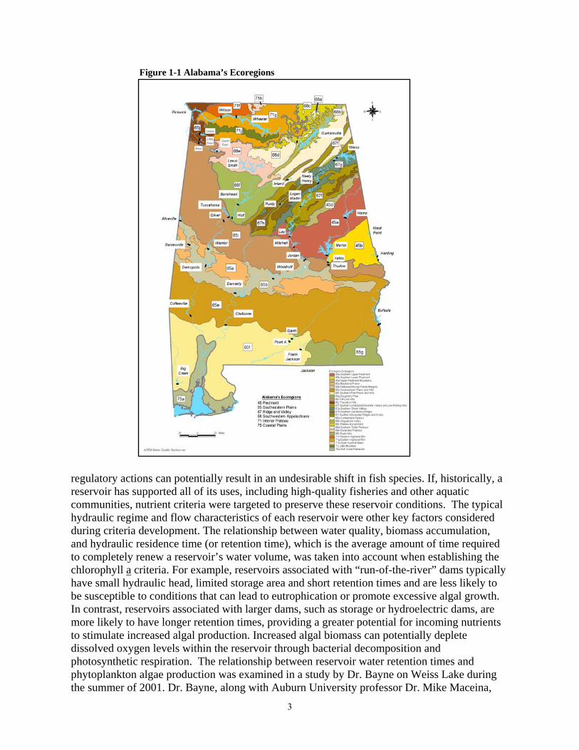
Figure 1-1 Alabama’s Ecoregions
regulatory actions can potentially result in an undesirable shift in fish species. If, historically, a reservoir has supported all of its uses, including high-quality fisheries and other aquatic communities, nutrient criteria were targeted to preserve these reservoir conditions. The typical hydraulic regime and flow characteristics of each reservoir were other key factors considered during criteria development. The relationship between water quality, biomass accumulation, and hydraulic residence time (or retention time), which is the average amount of time required to completely renew a reservoir’s water volume, was taken into account when establishing the chlorophyll a criteria. For example, reservoirs associated with “run-of-the-river” dams typically have small hydraulic head, limited storage area and short retention times and are less likely to be susceptible to conditions that can lead to eutrophication or promote excessive algal growth. In contrast, reservoirs associated with larger dams, such as storage or hydroelectric dams, are more likely to have longer retention times, providing a greater potential for incoming nutrients to stimulate increased algal production. Increased algal biomass can potentially deplete dissolved oxygen levels within the reservoir through bacterial decomposition and photosynthetic respiration. The relationship between reservoir water retention times and phytoplankton algae production was examined in a study by Dr. Bayne on Weiss Lake during the summer of 2001. Dr. Bayne, along with Auburn University professor Dr. Mike Maceina,
3
assessed the potential water quality effects on Weiss Lake of the draft Coosa River water-sharing agreement between Alabama and Georgia. Their study showed that reservoirs with typically short retention times, such as reservoirs on the Coosa River, are more susceptible to hypereutrohic effects and higher chlorophyll a concentrations when retention times are increased even moderately. Historical data shows that higher chlorophyll a concentrations in Weiss Lake have consistently corresponded to longer retention times. Hydrologic models in their study indicated that longer retention times in the reservoir would likely increase phytoplankton algae production and algal biomass accumulation, assuming that other factors remain unchanged. This result is particularly evident during drought periods, such as occurred in 2000 and in 2006. Also, the nutrient criteria were developed to reflect downstream transport of nutrients and the processes by which nutrient uptake occurs in streams. Nutrient concentrations generally tend to decrease as they move downstream. This attenuation occurs as nutrients are absorbed by micro-organisms and plants (biotic uptake) or as they adsorb onto sediment particles (abiotic uptake) and settle out of the water column. Thus, in developing nutrient criteria, the chlorophyll a targets were set so that along certain stretches of river, each successive reservoir has a lower criteria value as you move downstream. This approach takes into account natural processes that determine nutrient concentrations and is protective of downstream water quality.
1.4 Implementation of Alabama’s Antidegradation Policy On June 25, 2002, the Alabama Environmental Management Commission adopted Rule 335-6-10-12, Implementation of the Antidegradation Policy. This rule codifies procedures for implementing the Department’s antidegradation policy (contained in Rule 335-6-10-.04) which was last amended in 1991 and approved that same year by the U.S. Environmental Protection Agency (EPA), Region 4. In response to a petition from the Legal Environmental Assistance Foundation (LEAF), in 1997 EPA requested that ADEM develop written procedures for implementing the state’s antidegradation policy.
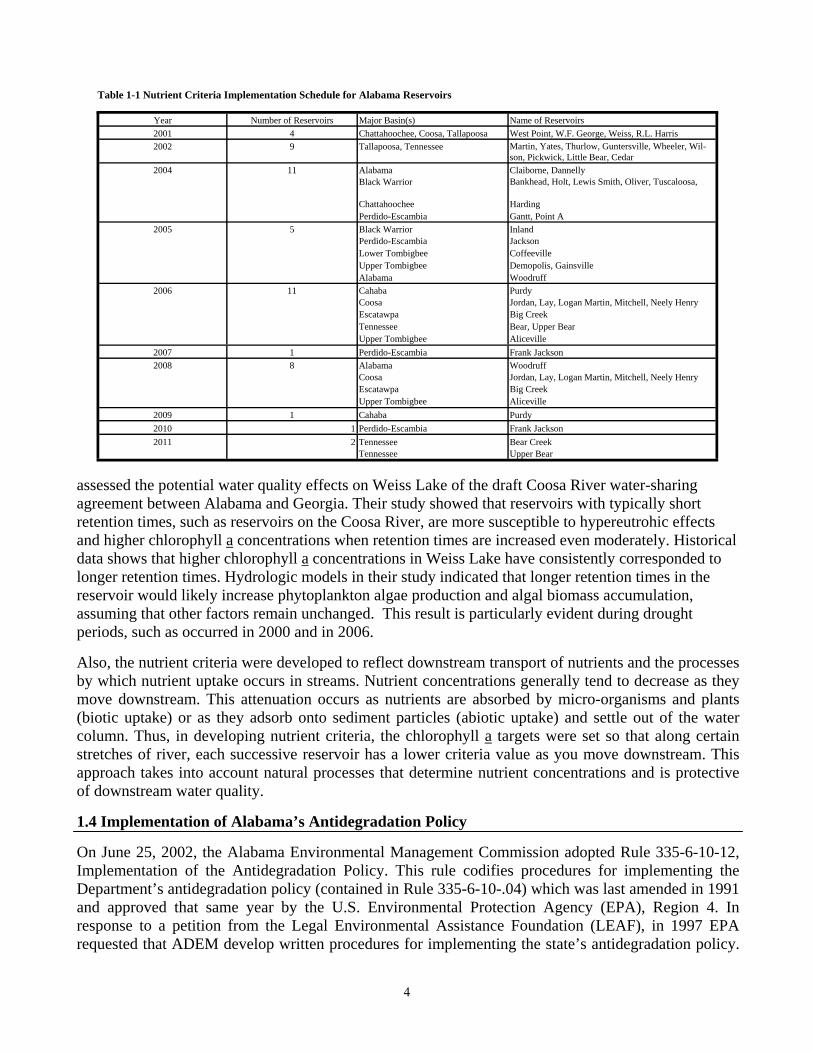
Table 1-1 Nutrient Criteria Implementation Schedule for Alabama Reservoirs
Year Number of Reservoirs Major Basin(s) Name of Reservoirs 2001 4 Chattahoochee, Coosa, Tallapoosa West Point, W.F. George, Weiss, R.L. Harris 2002 9 Tallapoosa, Tennessee Martin, Yates, Thurlow, Guntersville, Wheeler, Wil-
son, Pickwick, Little Bear, Cedar 2004 11 Alabama Claiborne, Dannelly
Black Warrior Bankhead, Holt, Lewis Smith, Oliver, Tuscaloosa,
Chattahoochee Harding Perdido-Escambia Gantt, Point A
2005 5 Black Warrior Inland Perdido-Escambia Jackson Lower Tombigbee Coffeeville Upper Tombigbee Demopolis, Gainsville Alabama Woodruff
2006 11 Cahaba Purdy Coosa Jordan, Lay, Logan Martin, Mitchell, Neely Henry Escatawpa Big Creek Tennessee Bear, Upper Bear Upper Tombigbee Aliceville
2007 1 Perdido-Escambia Frank Jackson 2008 8 Alabama Woodruff
Coosa Jordan, Lay, Logan Martin, Mitchell, Neely Henry Escatawpa Big Creek Upper Tombigbee Aliceville
2009 1 Cahaba Purdy 2010 1 Perdido-Escambia Frank Jackson 2011 2 Tennessee Bear Creek
Tennessee Upper Bear
4
Final written implementation procedures were submitted to EPA in December 1998 and approved by EPA in August 1999.In November 1999, LEAF sued ADEM alleging that the Department’s use of the EPA-approved implementation procedures in the NPDES permitting process was improper because these procedures were, in act, “rules” that had not been adopted through the formal rulemaking process. The Montgomery Circuit Court found in favor of ADEM; a decision later affirmed by the Court of Civil Appeals. LEAF then applied for a writ of certiorari to the Alabama Supreme Court, which was granted, and thereafter the Alabama Supreme Court concluded in a decision dated March 1, 2002, that the implementation procedures are “rules” within the context of the Alabama Administrative Procedure Act, reversed the judgment of the Court of Civil Appeals and remanded the case to the lower courts. As a result of the Supreme Court decision, the Department ceased the review of permit applications for new or expanded discharges of treated wastewater to those waters affected by the Supreme Court decision until April 10, 2002, following adoption by the Alabama Environmental Management Commission of emergency rule (335-6-10-.12-.01ER) establishing implementation procedures. As adopted, the emergency rule procedures incorporate suggestions made by EPA and are essentially equivalent to the written procedures utilized by the Department prior to the Supreme Court decision. The provisions of the permanent rule adopted on June 25, 2002, are the same as those of the emergency rule and, as such, have been determined by EPA to be consistent with the federal requirement for implementation procedures included in EPA’s water quality standards regulation. The final implementation procedures rule became effective on August 1, 2002. The Department’s antidegradation policy serves to conserve and protect the waters of Alabama and their beneficial uses and to prevent the deterioration of a water body even when its water quality surpasses the level necessary to meet the fishable and swimmable goals of the Clean Water Act. The antidegradation implementation policy addresses three categories of waters and beneficial uses:
• High-quality waters that constitute an outstanding national resource (Tier 3 waters);
• Waters where the quality exceeds levels necessary to support propagation of fish, shellfish, and wildlife as well as recreation in and on the water (Tier 2 waters); and
• Existing instream water uses and the level of water quality necessary to protect the existing uses (Tier 1 waters).
• The implementation policy codifies procedures for reviewing applications for new or expanded discharges to waters designated as Tier 2 waters. The two basic components of the implementation policy involve:
• The Departments determination, based on the applicant’s demonstration, that the proposed discharge is necessary for important economic or social development in the area in which the waters are located; and
• An evaluation by the applicant of alternatives other than the proposed discharge to Tier 2 water.
• The antidegradation implementation procedures comply with federal law and provides ADEM with adequate guidelines for making environmentally and economically sound decisions, industries with the predictability needed to operate and the public with the assurances needed to guarantee clean water.
5
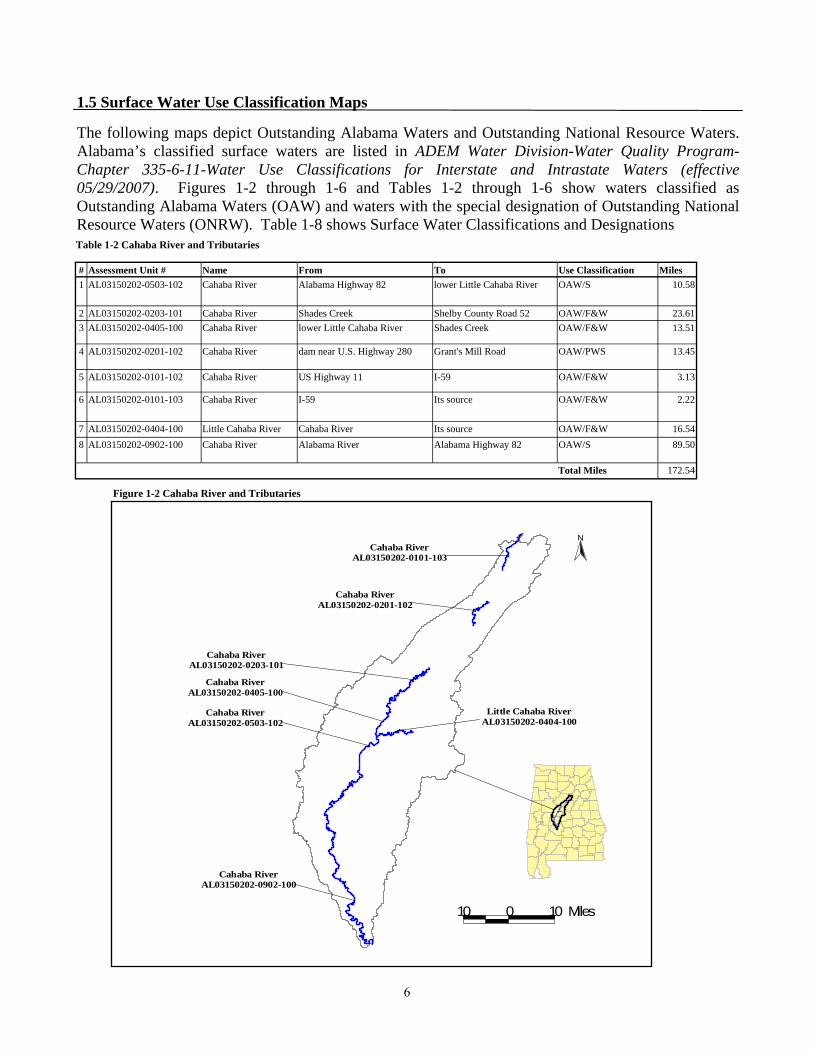
# Assessment Unit # Name From To Use Classification Miles 1 AL03150202-0503-102 Cahaba River Alabama Highway 82 lower Little Cahaba River OAW/S 10.58
2 AL03150202-0203-101 Cahaba River Shades Creek Shelby County Road 52 OAW/F&W 23.61 3 AL03150202-0405-100 Cahaba River lower Little Cahaba River Shades Creek OAW/F&W 13.51
4 AL03150202-0201-102 Cahaba River dam near U.S. Highway 280 Grant's Mill Road OAW/PWS 13.45
5 AL03150202-0101-102 Cahaba River US Highway 11 I-59 OAW/F&W 3.13
6 AL03150202-0101-103 Cahaba River I-59 Its source OAW/F&W 2.22
7 AL03150202-0404-100 Little Cahaba River Cahaba River Its source OAW/F&W 16.54 8 AL03150202-0902-100 Cahaba River Alabama River Alabama Highway 82 OAW/S 89.50
Total Miles 172.54
Table 1-2 Cahaba River and Tributaries
#
C ahab a R iv e rA L0315020 2 - 0 9 02- 100
#
Little Cahaba RiverAL03150202-0404-100
#
Cahaba RiverA L03150202-0201-102
#
Cahaba RiverAL03150202-0101-103
#
C ah ab a Ri v e r A L 0 3 150202 -0 5 0 3- 102 #
C ah ab a Ri v e r A L 0 3 150202 -0 4 0 5- 100
#
C ah aba R i v e r AL03150202- 0 2 0 3 - 1 01
N
10 0 10 M i l e s
Figure 1-2 Cahaba River and Tributaries
1.5 Surface Water Use Classification Maps The following maps depict Outstanding Alabama Waters and Outstanding National Resource Waters. Alabama’s classified surface waters are listed in ADEM Water Division-Water Quality Program-Chapter 335-6-11-Water Use Classifications for Interstate and Intrastate Waters (effective 05/29/2007). Figures 1-2 through 1-6 and Tables 1-2 through 1-6 show waters classified as Outstanding Alabama Waters (OAW) and waters with the special designation of Outstanding National Resource Waters (ONRW). Table 1-8 shows Surface Water Classifications and Designations
6
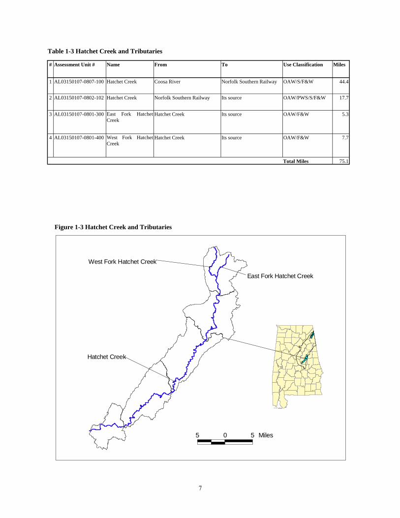
# Assessment Unit # Name From To Use Classification Miles
1 AL03150107-0807-100 Hatchet Creek Coosa River Norfolk Southern Railway OAW/S/F&W 44.4
2 AL03150107-0802-102 Hatchet Creek Norfolk Southern Railway Its source OAW/PWS/S/F&W 17.7
3 AL03150107-0801-300 East Fork Hatchet Creek
Hatchet Creek Its source OAW/F&W 5.3
4 AL03150107-0801-400 West Fork Hatchet Creek
Hatchet Creek Its source OAW/F&W 7.7
Total Miles 75.1
Table 1-3 Hatchet Creek and Tributaries
#
West Fork Hatchet Creek#
East Fork Hatchet Creek
#
Hatchet Creek
5 0 5 Miles
Figure 1-3 Hatchet Creek and Tributaries
7
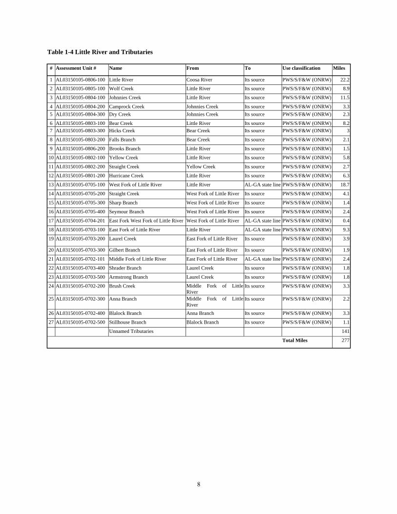
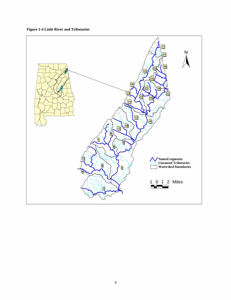
Table 1-4 Little River and Tributaries
# Assessment Unit # Name From To Use classification Miles
1 AL03150105-0806-100 Little River Coosa River Its source PWS/S/F&W (ONRW) 22.2
2 AL03150105-0805-100 Wolf Creek Little River Its source PWS/S/F&W (ONRW) 8.9
3 AL03150105-0804-100 Johnnies Creek Little River Its source PWS/S/F&W (ONRW) 11.5
4 AL03150105-0804-200 Camprock Creek Johnnies Creek Its source PWS/S/F&W (ONRW) 3.3 5 AL03150105-0804-300 Dry Creek Johnnies Creek Its source PWS/S/F&W (ONRW) 2.3
6 AL03150105-0803-100 Bear Creek Little River Its source PWS/S/F&W (ONRW) 8.2 7 AL03150105-0803-300 Hicks Creek Bear Creek Its source PWS/S/F&W (ONRW) 3
8 AL03150105-0803-200 Falls Branch Bear Creek Its source PWS/S/F&W (ONRW) 2.1
9 AL03150105-0806-200 Brooks Branch Little River Its source PWS/S/F&W (ONRW) 1.5
10 AL03150105-0802-100 Yellow Creek Little River Its source PWS/S/F&W (ONRW) 5.8
11 AL03150105-0802-200 Straight Creek Yellow Creek Its source PWS/S/F&W (ONRW) 2.7
12 AL03150105-0801-200 Hurricane Creek Little River Its source PWS/S/F&W (ONRW) 6.3
13 AL03150105-0705-100 West Fork of Little River Little River AL-GA state line PWS/S/F&W (ONRW) 18.7
14 AL03150105-0705-200 Straight Creek West Fork of Little River Its source PWS/S/F&W (ONRW) 4.1
15 AL03150105-0705-300 Sharp Branch West Fork of Little River Its source PWS/S/F&W (ONRW) 1.4
16 AL03150105-0705-400 Seymour Branch West Fork of Little River Its source PWS/S/F&W (ONRW) 2.4
17 AL03150105-0704-201 East Fork West Fork of Little River West Fork of Little River AL-GA state line PWS/S/F&W (ONRW) 0.4
18 AL03150105-0703-100 East Fork of Little River Little River AL-GA state line PWS/S/F&W (ONRW) 9.3
19 AL03150105-0703-200 Laurel Creek East Fork of Little River Its source PWS/S/F&W (ONRW) 3.9
20 AL03150105-0703-300 Gilbert Branch East Fork of Little River Its source PWS/S/F&W (ONRW) 1.9
21 AL03150105-0702-101 Middle Fork of Little River East Fork of Little River AL-GA state line PWS/S/F&W (ONRW) 2.4
22 AL03150105-0703-400 Shrader Branch Laurel Creek Its source PWS/S/F&W (ONRW) 1.8
23 AL03150105-0703-500 Armstrong Branch Laurel Creek Its source PWS/S/F&W (ONRW) 1.8
24 AL03150105-0702-200 Brush Creek Middle Fork of Little River
Its source PWS/S/F&W (ONRW) 3.3
25 AL03150105-0702-300 Anna Branch Middle Fork of Little River
Its source PWS/S/F&W (ONRW) 2.2
26 AL03150105-0702-400 Blalock Branch Anna Branch Its source PWS/S/F&W (ONRW) 3.3
27 AL03150105-0702-500 Stillhouse Branch Blalock Branch Its source PWS/S/F&W (ONRW) 1.1
Unnamed Tributaries 141
Total Miles 277
8
1 0 1 2 Miles
N
Watershed boundariesUnnamed TributariesNamed segments
2
13
5
4
6
7
8
9
1011
12
13
14
15
16
17
18
19
20
22
23
2625
27
24
21
Figure 1-4 Little River and Tributaries
9
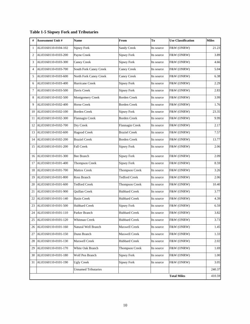
Table 1-5 Sispsey Fork and Tributaries
# Assessment Unit # Name From To Use Classification Miles
1 AL03160110-0104-102 Sipsey Fork Sandy Creek Its source F&W (ONRW) 21.23
2 AL03160110-0103-200 Payne Creek Sipsey Fork Its source F&W (ONRW) 3.89
3 AL03160110-0103-300 Caney Creek Sipsey Fork Its source F&W (ONRW) 4.66
4 AL03160110-0103-700 South Fork Caney Creek Caney Creek Its source F&W (ONRW) 5.04
5 AL03160110-0103-600 North Fork Caney Creek Caney Creek Its source F&W (ONRW) 6.38
6 AL03160110-0103-400 Hurricane Creek Sipsey Fork Its source F&W (ONRW) 2.29
7 AL03160110-0103-500 Davis Creek Sipsey Fork Its source F&W (ONRW) 2.83
8 AL03160110-0102-500 Montgomery Creek Borden Creek Its source F&W (ONRW) 3.99
9 AL03160110-0102-400 Horse Creek Borden Creek Its source F&W (ONRW) 1.76
10 AL03160110-0102-100 Borden Creek Sipsey Fork Its source F&W (ONRW) 23.35
11 AL03160110-0102-300 Flannagin Creek Borden Creek Its source F&W (ONRW) 9.99
12 AL03160110-0102-700 Dry Creek Flannagin Creek Its source F&W (ONRW) 2.17
13 AL03160110-0102-600 Hagood Creek Braziel Creek Its source F&W (ONRW) 7.57
14 AL03160110-0102-200 Braziel Creek Borden Creek Its source F&W (ONRW) 13.77
15 AL03160110-0101-200 Fall Creek Sipsey Fork Its source F&W (ONRW) 2.06
16 AL03160110-0101-300 Bee Branch Sipsey Fork Its source F&W (ONRW) 2.09
17 AL03160110-0101-400 Thompson Creek Sipsey Fork Its source F&W (ONRW) 8.59
18 AL03160110-0101-700 Mattox Creek Thompson Creek Its source F&W (ONRW) 3.26
19 AL03160110-0101-800 Ross Branch Tedford Creek Its source F&W (ONRW) 2.06
20 AL03160110-0101-600 Tedford Creek Thompson Creek Its source F&W (ONRW) 10.40
21 AL03160110-0101-900 Quillan Creek Hubbard Creek Its source F&W (ONRW) 3.77
22 AL03160110-0101-140 Basin Creek Hubbard Creek Its source F&W (ONRW) 4.39
23 AL03160110-0101-500 Hubbard Creek Sipsey Fork Its source F&W (ONRW) 6.59
24 AL03160110-0101-110 Parker Branch Hubbard Creek Its source F&W (ONRW) 3.82
25 AL03160110-0101-120 Whitman Creek Hubbard Creek Its source F&W (ONRW) 3.73
26 AL03160110-0101-160 Natural Well Branch Maxwell Creek Its source F&W (ONRW) 1.45
27 AL03160110-0101-150 Dunn Branch Maxwell Creek Its source F&W (ONRW) 1.33
28 AL03160110-0101-130 Maxwell Creek Hubbard Creek Its source F&W (ONRW) 2.02
29 AL03160110-0101-170 White Oak Branch Thompson Creek Its source F&W (ONRW) 1.69
30 AL03160110-0101-180 Wolf Pen Branch Sipsey Fork Its source F&W (ONRW) 1.00
31 AL03160110-0101-190 Ugly Creek Sipsey Fork Its source F&W (ONRW) 3.05
Unnamed Tributaries 240.37
Total Miles 410.59
10
N
1
23
4
5 6
7
8
9
10
1112
1314
15
16
17
18
1920
212
2
24
2526
228
Water shed boundaryUnn amed Tr ibutar iesNamed Segments
1 0 1 2 Miles
Figure 1-5 Sipsey Fork and Tributaries
11
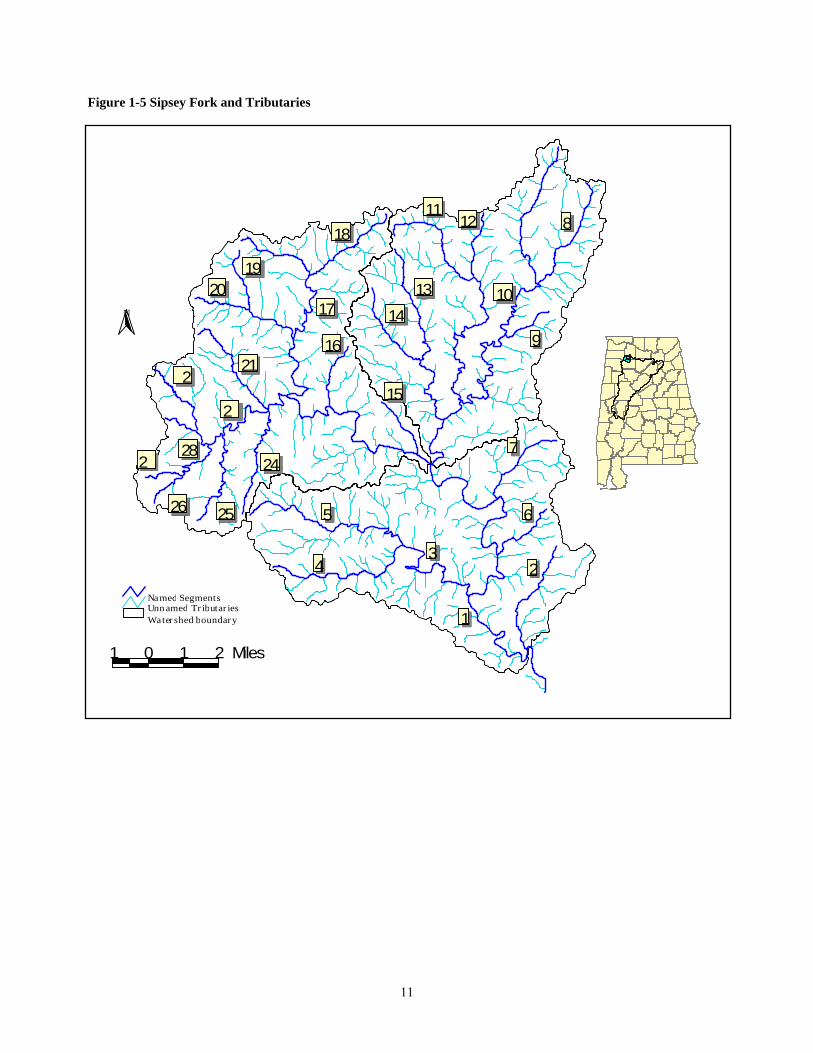
Table 1-6 Tensaw River, Weeks Bay and Tributaries
# Assessment Unit # Name From To Use Classification Miles
1 AL03160204-0505-202 Tensaw River Junction of Tensaw and Apalachee Rivers Junction of Briar Lake OAW/S/F&W 21.73
2 AL03160204-0105-302 Tensaw River Junction of Briar Lake Junction of Tensaw Lake OAW/F&W 2.93
3 AL03160204-0105-700 Briar Lake Junction of Tensaw River Junction of Tensaw Lake OAW/F&W 3.60
4 AL03160204-0105-801 Tensaw Lake Junction of Tensaw River Bryant Landing OAW/F&W 5.20
Total Miles 33.46
Weeks Bay and Tributaries # Assessment Unit # Name From To Use Classification Sq
Miles
1 AL03160205-0307-101 Weeks Bay Bon Secour Bay Fish River S/F&W (ONRW) 2.7
Total Square Miles 2.7
Tensaw River and Tributaries
T e n s a w River
T e n s a w L a k eBriar Lake
W e eks Bay
5 0 5 M i l e s
N
Figure 1-6 Tensaw River, Weeks Bay and
12
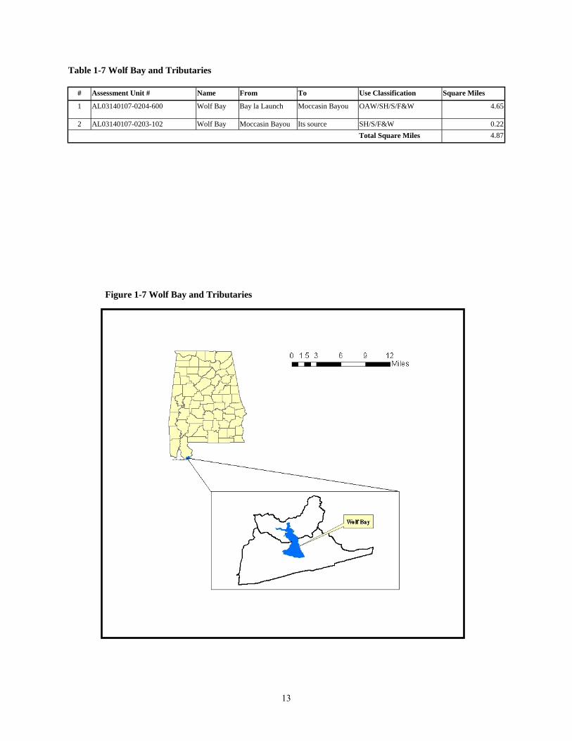
Table 1-7 Wolf Bay and Tributaries
# Assessment Unit # Name From To Use Classification Square Miles
1 AL03140107-0204-600 Wolf Bay Bay la Launch Moccasin Bayou OAW/SH/S/F&W 4.65
2 AL03140107-0203-102 Wolf Bay Moccasin Bayou Its source SH/S/F&W 0.22 Total Square Miles 4.87
Figure 1-7 Wolf Bay and Tributaries
13
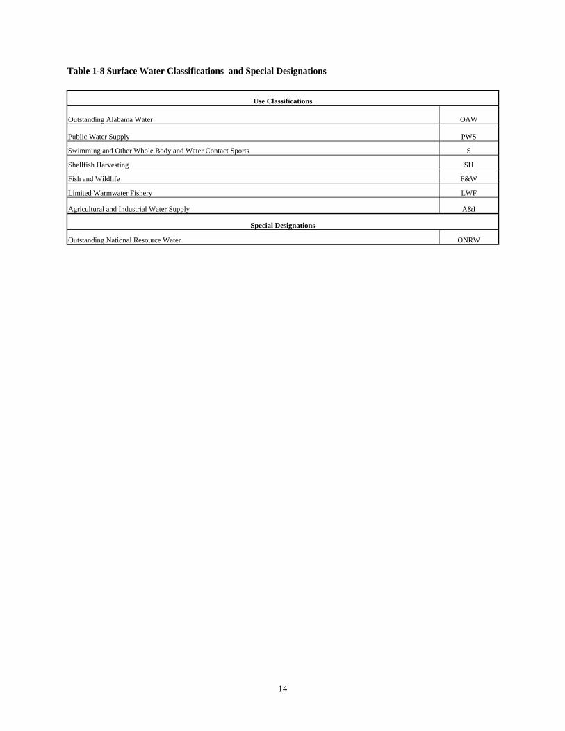
Table 1-8 Surface Water Classifications and Special Designations
Use Classifications
Outstanding Alabama Water OAW
Public Water Supply PWS
Swimming and Other Whole Body and Water Contact Sports S
Shellfish Harvesting SH
Fish and Wildlife F&W
Limited Warmwater Fishery LWF
Agricultural and Industrial Water Supply A&I
Special Designations
Outstanding National Resource Water ONRW
14