chapter 11 c. case study: massachusetts woodlands
TRANSCRIPT

115Chapter Eleven C
Chapter 11 C. Case Study: Massachusetts Woodlands Cooperative: A New Tool for Landscape Planning and Management
Paul Catanzaro, Department of Natural Resources Conservation, University of Massachusetts at Amherst, Holdsworth Natural Resources Center,
160 Holdsworth Way, Amherst, MA 01003 (413) 545-4839
“The most important objective for my property is wildlife.” Sound familiar? Wildlife is very often the objective given by landowners thinking about active forest management. Many people don’t have a particular wildlife species in mind; they just want to see more wildlife and know that they are managing their property in a way that benefits wildlife. In Massachusetts, like most of the Northeast, properties are becoming smaller and smaller and changing hands more frequently. People don’t own enough property to provide all of the habitat required for most species. It is becoming more important every day to look beyond our “stone walls” and develop tools that give landowners the ability to see their property as a part of a larger whole.
A group of like-minded landowners in Massachusetts got together in 1999 to share their forest management goals, as well as their common concerns. They decided to organize, since there is strength and opportunity in numbers. In the summer of 2001, they formally organized as the Massachusetts Woodlands Cooperative (MWC). This case study describes the MWC and how their cooperative efforts are turning into increased management opportunities and impacts, and particularly, how one MWC landowner is creating early-successional habitat to increase the habitat diversity of his landscape.
The landscape The MWC concentrates its efforts in western Massachusetts, with most of its membership concentrated
in the Westfield River watershed, located in the foothills of the Berkshires. Over 90% of the watershed is forested. Eighty percent of those forests are owned by what forestry professionals call
“non-industrial, private forest owners”, or NIPFs which is, of course, a complicated way of saying the forests of western Massachusetts are owned by individuals and families. With the amount of attention paid to publicly owned land, such as state forests, you may think that successful forest management is in the hands of state foresters. It’s not. Ultimately, the health of many of our forests, the quality of our water, and the diversity of our wildlife species is in the hands of what I call the ‘other 80%’…. that’s right - you!
Like much of the Northeast, our forests in the Westfield watershed are very similar in size, age, and species composition. This is due to the fact that our forests were established at relatively the same time in the early 1900s, after the clearing of the “old-field” white pine forest that established post-farm abandonment. The result is heavy forest cover that is very uniform. This is good news if you are a species that likes predominantly maturing forests, and we are seeing the return of many forest species such as bobcat, fisher, scarlet tanager, and thrushes. This is bad news if you are one of the many species that use early-successional habitat including farm fields, meadows, and young forests. These species include songbirds such as golden-winged warblers and eastern towhees as well as New England cottontails, ruffed grouse, American woodcock, and a variety of butterflies.
New tools The MWC is a forest-landowner management, processing, and marketing cooperative organized
by and on behalf of forest landowners in western Massachusetts. The MWC mission is to maintain the environment and character of western Massachusetts through the protection, enhancement, and careful economic development of one of the region’s most plentiful resources, the forest. The cooperative gives

116 Chapter Eleven C
landowners access to information, technology, expertise, and management options that private landowners by themselves simply cannot obtain.
MWC is developing a computerized Geographic Information System (GIS) with a relational database. The GIS system allows for the mapping of property lines and significant property features, such as wetlands or fields, by downloading hand held Global Positioning System readings into the GIS and then transferring them onto a map. The map gives landowners a sense of their property’s spatial relationship with other properties, both public and private. The database is being built to store information from the MWC members’ forest management plans (i.e., what types, sizes, and amounts of trees are on the property as well as any other significant resource areas such as wetlands and streams). When all of this information is put together for all of the MWC properties, it will be possible to assess the location of forest types and their structure, and to consider management opportunities. For example, if a particular landscape was predominantly mature forest, then diversifying the habitat type would include creating more early-successional habitat. Determining that a seven-acre stand of sapling hardwoods abuts a six-acre hay field becomes a management opportunity because the sizes of the trees are small enough to be mechanically removed and, together, the two areas (the sapling stand and the hay field) create a significant area, 13 acres worth, of early-successional habitat. The more landowners that join, the more information the GIS database holds, the more informed the management decisions.
Figure 1. GIS map of western Massachusetts, highlighting the location of current MWC member property locations.
117Chapter Eleven C
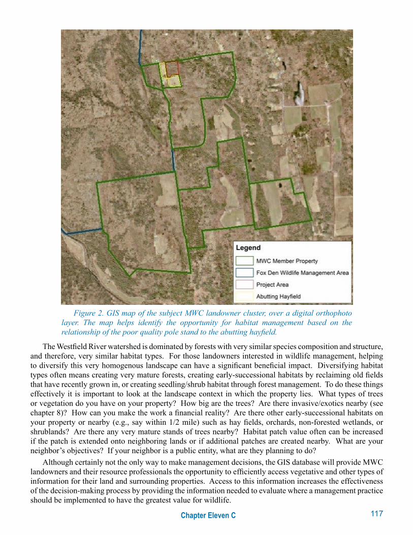
The Westfield River watershed is dominated by forests with very similar species composition and structure, and therefore, very similar habitat types. For those landowners interested in wildlife management, helping to diversify this very homogenous landscape can have a significant beneficial impact. Diversifying habitat types often means creating very mature forests, creating early-successional habitats by reclaiming old fields that have recently grown in, or creating seedling/shrub habitat through forest management. To do these things effectively it is important to look at the landscape context in which the property lies. What types of trees or vegetation do you have on your property? How big are the trees? Are there invasive/exotics nearby (see chapter 8)? How can you make the work a financial reality? Are there other early-successional habitats on your property or nearby (e.g., say within 1/2 mile) such as hay fields, orchards, non-forested wetlands, or shrublands? Are there any very mature stands of trees nearby? Habitat patch value often can be increased if the patch is extended onto neighboring lands or if additional patches are created nearby. What are your neighbor’s objectives? If your neighbor is a public entity, what are they planning to do?
Although certainly not the only way to make management decisions, the GIS database will provide MWC landowners and their resource professionals the opportunity to efficiently access vegetative and other types of information for their land and surrounding properties. Access to this information increases the effectiveness of the decision-making process by providing the information needed to evaluate where a management practice should be implemented to have the greatest value for wildlife.
Figure 2. GIS map of the subject MWC landowner cluster, over a digital orthophoto layer. The map helps identify the opportunity for habitat management based on the relationship of the poor quality pole stand to the abutting hayfield.

118 Chapter Eleven C
Do you need a GIS database to make sound management decisions for your property? Not necessarily. The concept that MWC hopes to apply through the GIS database system can still be applied without the technology. The idea is the same. Take a look at your property, consider it in the context of the surrounding landscape, and talk to your neighbors to find out what resources and management objectives they have. Although the “old-fashioned” way may not be as efficient, it can be equally effective on the ground and it is on-the-ground management that ultimately matters. The old-fashioned way may also have the added benefit of connecting or reconnecting you with your neighbors. Reconnecting this patchwork of properties is what it is all about, ecologically and even socially. Below is a case study that shows how one member of the MWC reconnected his landscape, with the help of a professional forester, by looking at his property as a part of the whole.
On the groundOne MWC member owns 327 acres. The property is a mix of forest types typical for the Westfield
watershed: northern hardwoods, hemlock, and white pine. There are a couple of perennial streams that flow through the property. The landowner has been involved with active forest management for ten years; ranging from timber stand improvement to selection system harvests that maintain the most vigorous trees in all age classes to wildlife clearings. Around the landowner’s home are 20 acres of fields that are mowed annually for hay. In his management plan, the landowner described his objectives as follows:
• Maintain and/or improve aesthetics and recreational access to the property.
• Maintain or enhance the property’s value as wildlife habitat.
• Increase forest productivity by improving stand quality and increasing growth rates.
• Generate revenue from occasional sales of forest products to fund some or all of the carrying costs of the property.
• Provide local employment by using/harvesting natural resources on the property in a small-scale, sustainable way.
The entire property is under the state’s Current Use Forest Tax Program, which reduces local property taxes in exchange for long-term, sustainable forest management. Approximately half of the property is permanently protected from development through a conservation easement with a local land trust that encourages long-term forest management. This easement allows the landowner to own the land, but forbids him, according to the terms of the easement, to develop it. Easement terms vary and can be customized to meet the needs of the owner. Even if the land is sold, the terms of the easement stay with the land. While easements diminish the value of the land, this reduction can translate into lower annual property taxes and reduced federal taxes, as well as lower inheritance taxes. Conservation easements have become a very effective tool for land conservation and estate planning. The landowner intends to put the other half of the property under conservation easement as well. If you’re interested in learning more about conservation easements, contact your local land trust or state environmental agency.
The 327-acre parcel is located in a rural, largely forested area. The property is abutted by private landowners, two of whom also have conservation easements, and by a portion of the 3,000-acre Hiram Fox Wildlife Management Area (WMA) (see Figure 2). The remainder of the WMA lies a short distance away, across a small dirt road. The WMA is managed by the Massachusetts Division of Fisheries and Wildlife. The most recent management activities on the WMA involved a 50-acre cut designed to mimic a natural disturbance. Only 10 to 12 wildlife trees per acre were retained.
The landowner hired a consulting forester and professional wildlife biologist to help him achieve his management objectives. The advantages of hiring professionals are many. They have the technical expertise to develop management plans, to represent the landowner when it is time to implement the plans to ensure that quality work is done at a fair price, and to help the landowner find reputable timber harvest operators and write strong contracts to protect a landowner and ensure goal achievement.
119Chapter Eleven C
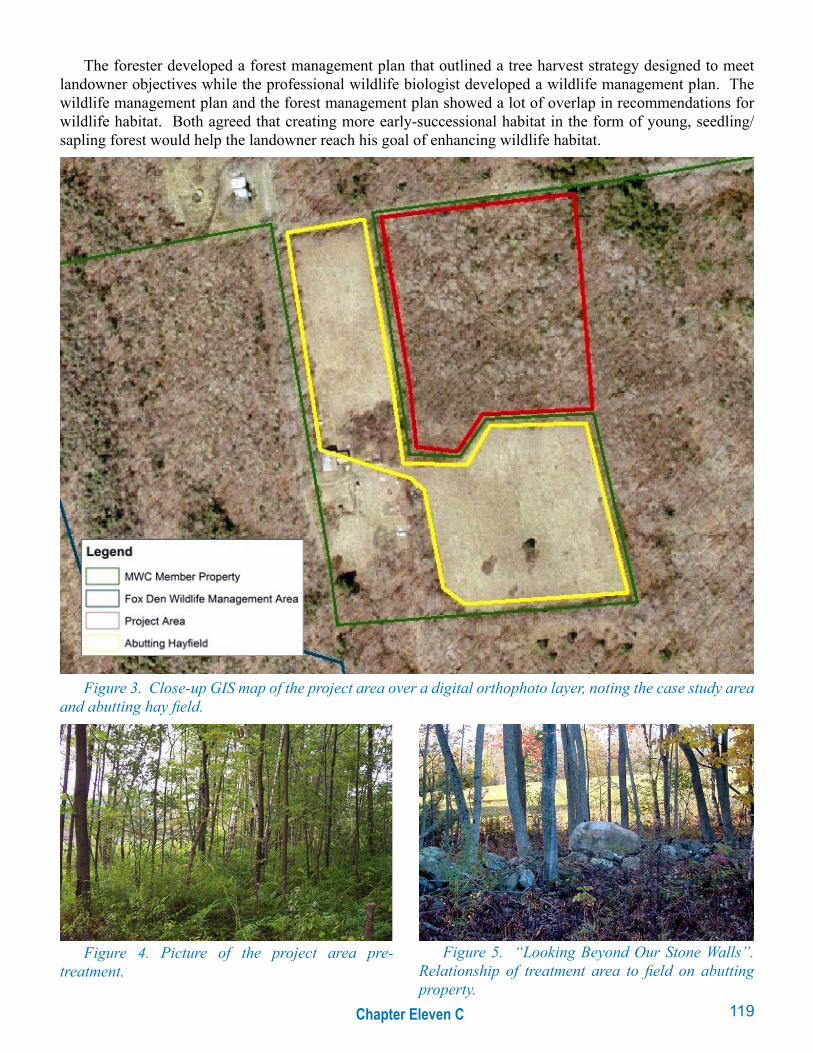
The forester developed a forest management plan that outlined a tree harvest strategy designed to meet landowner objectives while the professional wildlife biologist developed a wildlife management plan. The wildlife management plan and the forest management plan showed a lot of overlap in recommendations for wildlife habitat. Both agreed that creating more early-successional habitat in the form of young, seedling/sapling forest would help the landowner reach his goal of enhancing wildlife habitat.
Figure 3. Close-up GIS map of the project area over a digital orthophoto layer, noting the case study area and abutting hay field.
Figure 5. “Looking Beyond Our Stone Walls”. Relationship of treatment area to field on abutting property.
Figure 4. Picture of the project area pre-treatment.

120 Chapter Eleven C
The stand chosen for the project was an eight-acre area of low-value pioneer species, mostly aspen. Located in the very northwest corner of the property, the stand abuts a neighbor’s hay field. The consulting forester’s intent was not necessarily to attract a particular species of wildlife, but manage to reach an overall landscape target of 10 to 15% early-successional habitat to maximize wildlife diversity. The desire was to create early-successional seedling/sapling habitat by cutting almost everything. The stand boundaries were flagged, as were the shrubs and trees to be retained for food and structure, including highbush blueberry, old apple trees, shadbush, a few elm trees, and a large white-ash tree. The forester also assisted with applying for cost-sharing through the Natural Resource Conservation Service’s (NRCS) Wildlife Habitat Improvement Program (WHIP) and the U.S. Forest Service Forest Stewardship Incentive Program (SIP; renamed to Forestland Enhancement Program: Table 1). Both WHIP and SIP offer cost-share opportunities for wildlife habitat work on private land. Refer to chapter 12 for more information on these and other cost-share programs.
Public money is used on private land since tremendous public benefit flows from private forests, such as wildlife and clean water. Management on private land is essential to maximizing the benefit from our forests. In addition, since it is cost-shared, the limited amount of both public and private money can be stretched to do more work.
Once the job was set up and cost-share secured, the forester then contracted with an experienced operator to implement the harvest. The machine that was used is called a feller buncher, a tool similar to an excavator, but with a head on the boom that holds the tree, cuts it from the stump, then lays it on the ground. The feller buncher operator was able to cut approximately 2 1/2 acres a day. Since there was no merchantable value in the trees being cut and since chipping or hauling the material off-site would have been very costly, a decision was made to pile the slash. The piles were large, 25 feet high in some cases. The piles of slash also serve to act as potential den sites for black bears.
Figure 6. Feller-Buncher used in the treatment.
The location of the area (e.g., close to hay fields and open fields with old apple trees), coupled with the heavy, 50-acre cut on the nearby WMA enhanced the habitat value of the treatment because additional early-successional habitat was created within a relatively homogenous landscape. The site’s size (eight acres), poor species composition, poor quality (no loss in value from harvesting trees before maturity), and accessibility from the road (easier to get machinery to site) all made this a prime area to target for treatment. The goal of creating young, seedling/sapling forest was reached and the area is now valuable early-successional habitat in a mostly mature forested landscape. There are no formal plans to monitor the site, however the area is regularly monitored informally by the landowner and his neighbors while hiking a trail that runs through the opening.
121Chapter Eleven C
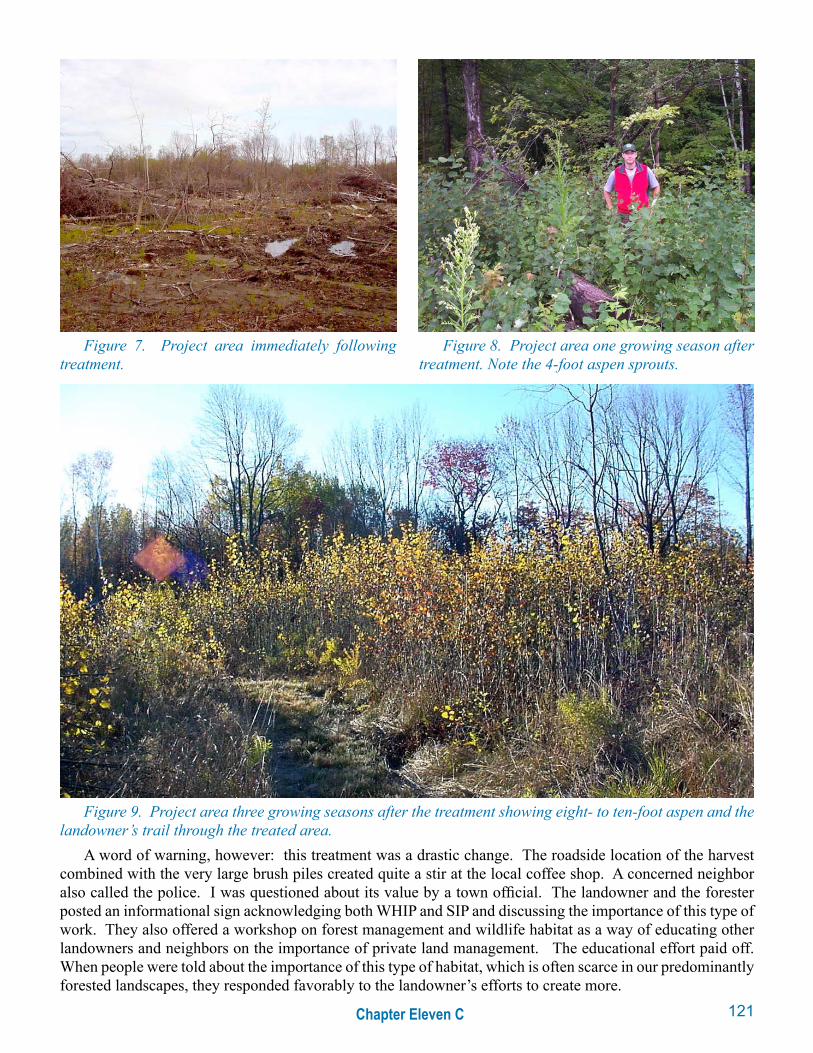
A word of warning, however: this treatment was a drastic change. The roadside location of the harvest combined with the very large brush piles created quite a stir at the local coffee shop. A concerned neighbor also called the police. I was questioned about its value by a town official. The landowner and the forester posted an informational sign acknowledging both WHIP and SIP and discussing the importance of this type of work. They also offered a workshop on forest management and wildlife habitat as a way of educating other landowners and neighbors on the importance of private land management. The educational effort paid off. When people were told about the importance of this type of habitat, which is often scarce in our predominantly forested landscapes, they responded favorably to the landowner’s efforts to create more.
Figure 7. Project area immediately following treatment.
Figure 9. Project area three growing seasons after the treatment showing eight- to ten-foot aspen and the landowner’s trail through the treated area.
Figure 8. Project area one growing season after treatment. Note the 4-foot aspen sprouts.

122 Chapter Eleven C
ConclusionThree hundred acres is a large ownership for Massachusetts, but relatively speaking, it is just a small
fraction of the landscape in which it sits. To improve wildlife habitat, landowners should begin looking across their stonewalls or property boundaries. Considering the placement of a property within a landscape can give a management activity more impact. This case study property is “sandwiched” between two other members of the Massachusetts Woodlands Cooperative. To the northwest of the property is the WMA (see Figure 2). In total the four properties contain 3,728 acres. Taken together, these properties have enough acreage to affect wildlife at the landscape level.
Simply talking about management objectives with neighbors can often provide information to help make better management decisions. Will your neighbor (either public or private) be harvesting in the near future? If yes, can you coordinate to help one another, such as each landowner placing five-acre patches close to the property line to create ten acres of habitat? If no, you now know that their property will continue to fill a particular niche in the landscape, perhaps a mature, even-aged northern hardwood forest. Diversifying habitat would then mean creating something different, such as early-successional habitat. Communicating and working together with neighbors, whether they are public, private or both, can help increase the effectiveness of your management plan and impact the larger landscape in a greater, more efficient way.
Working with neighbors can be done as informally as talking over a cup of coffee at a kitchen table or as formally as joining a group like the Massachusetts Woodlands Cooperative. As technology evolves, planning management activities with a landscape perspective becomes easier. Making these technological wonders available to landowners and professional resource managers can be difficult because of the expense and the time required to learn it. An organization such as the Massachusetts Woodlands Cooperative can provide the mechanism for technology transfer. Through economies of scale, it is hoped that the cooperative will be able to provide its members and their resource managers more information to make better-informed decisions, which will ultimately have a greater effect on the landscape in a more efficient way. Exploring new ways, or re-exploring the old ways in which landowners talk and work together will only become more important as properties continue to break into smaller pieces, while the burden of providing the public benefit of wildlife increases.
BiographyPaul Catanzaro is the Extension Forestry Specialist for the University of Massachusetts at Amherst in
the Department of Natural Resources Conservation. He was one of the innovators of the Massachusetts Woodlands Cooperative and has been instrumental in helping the MWC create a group certification model to achieve FSC Green Certification.
Costs
Clearing 8 acres: $5,600
Consulting forester: $1,120
Total project cost: $6,720
Reimbursements
WHIP cost-share (75%): $5,040
SIP cost-share: $1,222
Total reimbursements: $6,262
Total landowner contribution: $458
Table 1. Project and landowner costs for an 8-acre early-successional habitat opening, Westfield River watershed, Massachusetts.