chapter 11 urban emotions: benefits and risks in using ... · for the extraction of contextual...
TRANSCRIPT
Chapter 11Urban Emotions: Benefits and Risksin Using Human Sensory Assessmentfor the Extraction of ContextualEmotion Information in Urban Planning
Peter Zeile, Bernd Resch, Jan-Philipp Exner and Günther Sagl
Abstract This chapter introduces the ‘Urban Emotions’ approach. It focuses onintegrating humans’ emotional responses to the urban environment into planningprocesses. The approach is interdisciplinary and anthropocentric, i.e. citizens andcitizens’ perceptions are highlighted in this concept. To detect these emotions/per-ceptions, it combines methods from spatial planning, geoinformatics and computerlinguistics to give a better understanding of how people perceive and respond to staticand dynamic urban contexts in both time and geographical space. For collecting andanalyzing data on the emotional perception to urban space, we use technical andhuman sensors as well as georeferenced social media posts, and extract contextualemotion information from them. The resulting novel information layer provides anadditional, citizen-centric perspective for urban planners. In addition to technical andmethodological aspects, data privacy issues and the potential of wearables are dis-cussed in this chapter. Two case studies demonstrate the transferability of the
P. Zeile (&) � J.-P. ExnerDepartment of CAD and Planning Methods in Urban Planning and Architecture—CPE,University of Kaiserslautern, Kaiserslautern, Germanye-mail: [email protected]
J.-P. Exnere-mail: [email protected]
B. Resch � G. SaglDepartment of Geoinformatics—Z_GIS, University of Salzburg, Salzburg, Austriae-mail: [email protected]; [email protected]
B. Resch � G. SaglChair of GIScience, University of Heidelberg, Heidelberg, Germany
B. ReschCenter for Geographic Analysis, Harvard University, Cambridge, USA
G. SaglDepartment of Geoinformation and Environmental Technologies,Carinthia University of Applied Sciences, Salzburg, Austria
© Springer International Publishing Switzerland 2015S. Geertman et al. (eds.), Planning Support Systems and Smart Cities,Lecture Notes in Geoinformation and Cartography,DOI 10.1007/978-3-319-18368-8_11
209
approach into planning processes. This approach will potentially reveal new insightsfor the perception of geographical spaces in spatial planning.
1 Introduction
The question of how people perceive a city and how they feel about it has always beenan important issue in urban planning. Typically, citizens/residents as well as visitorsclassify existing urban situations or new planning projects with the attributes ‘good’ or‘bad’. “From a nonprofessional perspective, visual quality may be the most importantinfluence on how people experience and respond to urban areas and planning initia-tives” (Kaiser et al. 1995, p. 223). For instance, pedestrians or cyclists may emo-tionally respond differently to the city depending on a variety of context factorsincluding personal mood, environmental conditions like the weather, traffic density orroad conditions. Methods for an objective measurement of the quality of architectureand the resulting urban space last boomed in the late 1950s–1970s (Debord 1957;Lynch 1960; Cullen 1961; Franke and Bortz 1972; Krause 1974; Trieb 1974).However, in contrast to landscape design (Bishop and Hull 1991) or especiallyarchitectural design, there is still a scientific lack in the discussion of emotional aspectsin urban planning. This is relevant because the amenity value or perceived safety areimportant aspects for making decisions in many urban design proposals. In recentyears, the integration of technical and human sensors in combination with a directfeedback from citizens to stakeholders via real-time participatory communicationchannels (Burke et al. 2006), such as social media, enabled new insights into urbanpatterns, and dynamic and static contexts like traffic or architecture.
Research fields including computer science, geoinformatics, computational lin-guistics, sensor technology, citizen science, architecture and spatial planning areoverlapping impacts in this interdisciplinary topic, which we call ‘Urban Emotions’.Concisely, the Urban Emotions approach focuses on a new and human-centricperspective onto the city, in which humans as ‘users of a city’ represent the mainsensing element. Therefore, we combine and merge objective elements of sensortechnology with subjective measurement methods to create a ‘human sensor net-work’. The long-term goal is to develop a new information layer for planners, inwhich a visualization of the measured spatial perception is possible. These visu-alizations allow conclusions about human behavior in an urban environment andenable a new citizen-centered perspective in planning processes.
2 Scientific Background
The research field of human perception of the city originated from the 1970s anddeals with the perception of the natural and the built environment (Downs andMeyer 1978). Main components and the chosen cartographic representation are so
210 P. Zeile et al.
called ‘mental maps’ or ‘cognitive maps’. These maps reflect the subjective per-ception of a person in (urban) space segments (Downs and Stea 1974). ‘CognitiveMaps and Spatial behavior’ (Downs and Stea 1974) or ‘Image of the City’ (Lynch1960) describe the concepts of cognitive representation of space. “We are notsimply observers of this spectacle, but are ourselves a part of it, on the stage withthe other participants. […] Nearly every sense is in operation, and the image is thecomposite of them all” (Lynch 1960, p. 2).
These days, up-to-date methods like sensing or crowdsourcing offer a valuablesupplement in creating these maps and using them in spatial planning. Analog tech-niques like sketches or descriptions are combined with digital methods like the abovementioned. Emotions and space are linked closely. Each situation creates its ownspecific atmosphere and triggers an emotional reaction to the respective observer(Mody et al. 2009). The first to combine global positioning systems (GPS) data withbiometric human sensor data and investigate the question of collecting cartographicallyreferenced emotional data was Christian Nold in 2004 with his project ‘Biomapping’.Therefore, it was possible to visualize user gathered psychophysiological data andshare with the community. In his collection of essays entitled ‘Emotional Cartography’,he presents this concept and other works around the topic of collecting data for a betterunderstanding of people’s perception in urban areas (Nold 2009).
Besides the emotion aspects, the perception of humans’ urban surroundings andhow they were created or triggered is another important point/perspective. Feelingsor perceptions are important key facts and not negligible aspects in urban planning,especially for supporting recommendations in design processes and in someinfrastructure projects like trespassing of streets, cycle lanes etc. The UrbanEmotions concept refers closely to new methods of a ‘new understanding of cities’,beginning with Baudelaire’s ‘flaneur’, Patrick Geddes’ ‘outlook tower’ from 1892,Walter Benjamin’s ‘Passagen-Werk’ from the late 1920s/40s (Benjamin andTiedemann 1983), concept of ‘dérive’ (Debord 1956) and ‘guidepsychogéographique de Paris’ (Debord 1957) up to Lynch’s ‘mental maps’.
2.1 New Kinds of Participation—Urban Emotions as NewInformation Layers Within Planning Processes
“Cities have the capability of providing something for everybody, only because,and only when, they are created by everybody” (Jacobs 1961, p. 238). Spatialplanning is cross-sectional and interdisciplinary and takes into account all spatialand social structures within the city. In an ideal case, all public and private interestsare evaluated to minimize conflicts within planning processes. The quote fromJacobs highlights the need to develop an ideal type of participatory spatial planningapproach for a ‘good’ and citizen-centric planning. This includes theoretical visionsas well as human centered implementation strategies.
However, the question is: how can relevant and objective issues be measuredand included in the process of planning and evaluation? And why is the use and
11 Urban Emotions: Benefits and Risks in Using Human Sensory … 211

knowledge about citizens’ emotion so interesting for urban designers and planners?Moreover, how can planners recognize which problems citizens are really con-fronted with in a spatial context?
The use of emotions in urban design is not well-established and far grown. Oneof the few research efforts is presented by Hoch (2006), yet describing the use ofemotional intelligence in communication in planning processes rather than psy-chophysiological measurements. In landscape design, the discussion of an accep-tance of a project is much more integrated in the scientific discourse. Bishop andHull (1991) discussed ‘visual quality’ of landscapes as an important emotionalissue, even for planners and stakeholders. In the context of ‘mental health’, theystate: “Emotional and mental well-being may be one benefit of a high-quality visualenvironment. (…) On the negative side, the cluttered visual environment may bedistracting and cause stress or emotions which hinder the accomplishment of one’sobjectives.” (Bishop and Hull 1991, p. 298). Good visual quality is, according tothe authors, good for residential satisfaction and an overall confidence in landmanagement. These aspects “should be the concern of landscape management andplanning because they are socially relevant” (Bishop and Hull 1991, p. 298). Thesefindings will be adopted in Urban Emotions and transferred to other applicationareas in the domain of urban planning.
The Urban Emotions concept also tries to give the answer by developing a newset of methods for urban planning and spatial planning. Taken into account are theconcepts of a network society (Castells 1996), which will join up today’s funda-mental change of the understanding of planning (Streich 2014). So-called bottom–
up processes of participation, a proactive involvement of citizens, are the coreelements in this strategy. So, the repertoire of methods in spatial and urban planninghas to be extended significantly by using this ‘sensor technologies’; traditionaldeductive planning will be supplemented by inductive planning approaches, like theabove mentioned crowdsourcing processes in bottom-up mode (Streich 2014).
2.2 Techniques, Wearable Computing and ‘Quantified-Self’Movement
There are several techniques for detecting emotions. One is to combine severaltechnical sensors into a new network. A simple configuration and a communicationhub for detecting emotions are enabled by the new generation of smartphones. GPS,microphones and cameras are the basic requirements of participatory sensing(Burke et al. 2006). Smartphones are probably the most efficient standard sensingdevices in daily life, because they are mobile, embedded and, thus in situ (Martinoet al. 2010). Further, the smartphone’s integrated sensors for physical activities willcome into vogue more and more. “The mobile phone is the new gateway to people-centric urban sensing, a new sensor-networking paradigm that leverages humans aspart of the sensing infrastructure” (Martino et al. 2010, p. 2).
212 P. Zeile et al.
Wearable devices are portable mini computers equipped with various sensors,which are always on and always ready and accessible (Mann 1998) and constitute asupplement for smartphones (Schumacher 2013). They should serve as an “intel-ligent daily assistant”, in which the user’s role is passive without any explicit datainput (Kotrotsios and Luprano 2011, p. 279). State-of-the-art wearables allow us tomeasure physiological data like skin conductance, skin temperature or electrocar-diography (ECG) and it is possible to derive indicators of negative arousal fromthese datasets. Hence, wearable technology has an increasingly important role insupporting everyday life and is essential equipment in the Quantified-Self and LifeLogging movement.
Kevin Kelly and Gary Wolf initiated the Quantified-Self movement in 2007.“Self-knowledge through self-observation” is the slogan of the movement. Peoplemeasure their bio data digitally and want to learn from these data, to live better, orat least to be able to understand certain physical and psychological processes better(Klausnitzer 2013, p. 29).
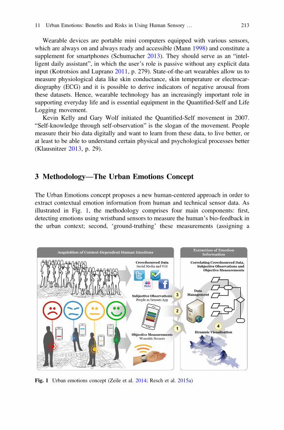
3 Methodology—The Urban Emotions Concept
The Urban Emotions concept proposes a new human-centered approach in order toextract contextual emotion information from human and technical sensor data. Asillustrated in Fig. 1, the methodology comprises four main components: first,detecting emotions using wristband sensors to measure the human’s bio-feedback inthe urban context; second, ‘ground-truthing’ these measurements (assigning a
Fig. 1 Urban emotions concept (Zeile et al. 2014; Resch et al. 2015a)
11 Urban Emotions: Benefits and Risks in Using Human Sensory … 213

formal emotion category to each measurement) using a ‘people as sensors’ location-aware mobile application; third, extracting emotion information from crowdsourceddata and geo-social media like Twitter; and fourth, correlating the measured andextracted emotions in order to provide urban planners with additional insights intothe complex human-city relationships. However, the Urban Emotions concept’smajor innovation is its trans-disciplinary nature as it consolidates the know-howand perspectives of at least four additional scientific disciplines, namely GIScience,computational linguistics, sociology and computer science. Hence, the contextualemotion information extracted can serve as the citizens’ direct feedback for urbanplanning and decision support for ongoing planning and design processes.
The most important factor in this approach is that Urban Emotions is not con-ceived as a general tool of solving all planning tasks, but it can help to createanother view and better understanding of ‘the body of the city’. A big successwould be, if this new knowledge can be integrated as a fact or indicator system inweighting in official planning processes. Urban Emotions can provide valuableinformation not in every case, but in special tasks like the above mentioned designprocesses or in the discussion of personal perceived safety.
3.1 Modes of Measuring Emotions
There are several modes to measure the emotions of people within physical spaces.These range from simple online questionnaires to a basic localization ‘tagging’ ofthe attributes ‘good’ or ‘bad’ using a smartphone app, over automated text-extraction from social media channels up to psychophysiological measurements.These different modes are considered in the Urban Emotions concepts andexplained in detail below.
3.1.1 Tagging
An easy method is to ‘tag’ annotations with the help of a digital place mark withinthe urban space. This is for example possible by using the smartphone RADARSENSING app, with which users can locate explicitly GPS-based positive ornegative impressions within urban areas (Zeile et al. 2012). The RADAR infra-structure (Memmel and Groß 2011) can generate ‘on the fly heat maps’ or ‘densitymaps’ out of the attributed dataset. The RADAR SENSING app runs onAndroidOS devices and saves all the information such as user data and user con-tributions in an appropriate database in RADAR SENSING back-end. Simply aregistration and the installation of the RADAR SENSING app are required. Thenusers can give both negative and positive ratings, with the help of predefinedcategories, all relevant to planning issues. If there is a missing category, it is alsopossible to define a free text for a new classification. In order to ensure easy and fasthandling, the app locates the user’s position directly with the help of several sensors
214 P. Zeile et al.
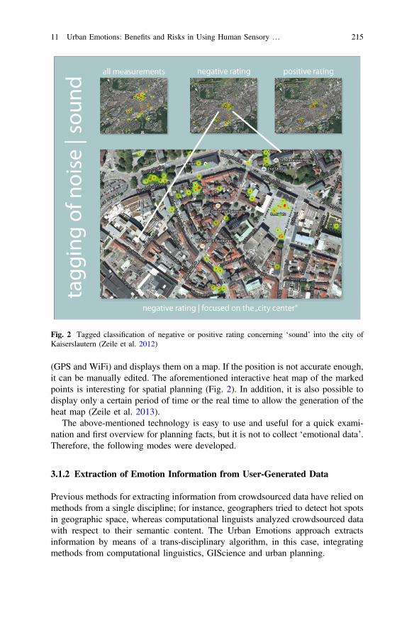
(GPS and WiFi) and displays them on a map. If the position is not accurate enough,it can be manually edited. The aforementioned interactive heat map of the markedpoints is interesting for spatial planning (Fig. 2). In addition, it is also possible todisplay only a certain period of time or the real time to allow the generation of theheat map (Zeile et al. 2013).
The above-mentioned technology is easy to use and useful for a quick exami-nation and first overview for planning facts, but it is not to collect ‘emotional data’.Therefore, the following modes were developed.
3.1.2 Extraction of Emotion Information from User-Generated Data
Previous methods for extracting information from crowdsourced data have relied onmethods from a single discipline; for instance, geographers tried to detect hot spotsin geographic space, whereas computational linguists analyzed crowdsourced datawith respect to their semantic content. The Urban Emotions approach extractsinformation by means of a trans-disciplinary algorithm, in this case, integratingmethods from computational linguistics, GIScience and urban planning.
Fig. 2 Tagged classification of negative or positive rating concerning ‘sound’ into the city ofKaiserslautern (Zeile et al. 2012)
11 Urban Emotions: Benefits and Risks in Using Human Sensory … 215

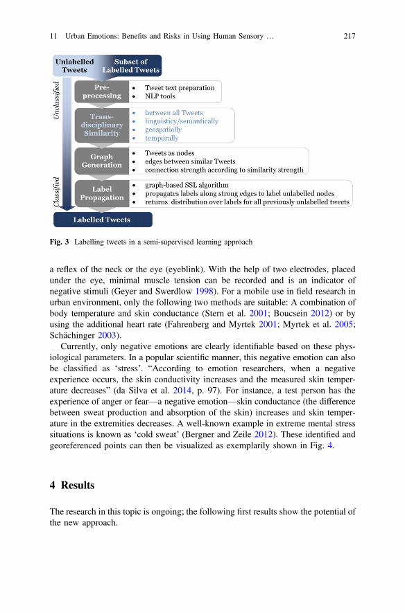
Figure 3 shows the workflow for the extraction of information from unstructureddatasets like Twitter tweets. Generally speaking, the algorithm assigns an emotionalquality (joy, anger, fear, sadness, surprise and disgust) to each tweet. In practice,this means that we produce a set of labelled tweets from initially unlabeled tweets infour steps. First, the tweet text is pre-processed by applying basic text processingalgorithms (part-of-speech [POS] tagging to detect emoticons, negations, etc.) andby comparing their content to the Affective Norms for English Words (ANEW)word list. Second, the similarity between all tweets is computed according to threedimensions: linguistic and semantic content, temporal distance, and geo-spatialdistance. Third, a tweet graph is constructed, where “thicker” edges between tweetsindicate higher similarity scores. Fourth, a graph-based label propagation algorithmis applied to the graph, resulting in a probability distribution over all labels for eachpreviously unlabeled node. The methodological details of the approach aredescribed in Resch et al. (2015a).
3.1.3 “People as Sensors” for Ground-Truthing EmotionMeasurements
Current emotion sensors are able to detect spikes in different biometric parameterslike additional heart rate, skin conductance or body temperature, but they are notcapable of identifying the emotional quality, as mentioned above. To address thisshortcoming, a ‘people as sensors’ smartphone app was developed, with whichpersons can manually enter the emotional category and the according context in thecase of an emotional spike (Resch 2013). So, the app’s inputs are twofold, namelyobjective sensor measurements, and subjective observations—both are send to theback-end (refer to Fig. 1). In the design of the app, the main challenge was toaccount for technological requirements for web development and at the same timeintegrate psychological theories for interaction design and emotion detection. Moreinformation about the design can be found in Resch et al. (2015a). The technicaldesign considerations including the standardized communication with the back-endwill be presented in Resch et al. (2015b).
3.1.4 Psychophysiological Monitoring
The so-called psychophysiological monitoring is the technology to measure thearousal of a person. In principle, the measurement occurs in nearly real time andprovides data about the change in body reactions (body physiology) of a participant.There is a variety of assessment methods to identify emotions (Schumacher 2014).Using ‘emotional stimuli’ with IAPS (International Affective Picture System), inwhich a collection of pictures is shown representing the range of human experienceand the users rate them with the attributes ‘positive’, ‘negative’ or ‘neutral’(Bradley and Lang 2007). Another method is to measure the ‘startle reflex’, aperipheral physiological parameter. Thereby, negative stimuli can be measured over
216 P. Zeile et al.
a reflex of the neck or the eye (eyeblink). With the help of two electrodes, placedunder the eye, minimal muscle tension can be recorded and is an indicator ofnegative stimuli (Geyer and Swerdlow 1998). For a mobile use in field research inurban environment, only the following two methods are suitable: A combination ofbody temperature and skin conductance (Stern et al. 2001; Boucsein 2012) or byusing the additional heart rate (Fahrenberg and Myrtek 2001; Myrtek et al. 2005;Schächinger 2003).
Currently, only negative emotions are clearly identifiable based on these phys-iological parameters. In a popular scientific manner, this negative emotion can alsobe classified as ‘stress’. “According to emotion researchers, when a negativeexperience occurs, the skin conductivity increases and the measured skin temper-ature decreases” (da Silva et al. 2014, p. 97). For instance, a test person has theexperience of anger or fear—a negative emotion—skin conductance (the differencebetween sweat production and absorption of the skin) increases and skin temper-ature in the extremities decreases. A well-known example in extreme mental stresssituations is known as ‘cold sweat’ (Bergner and Zeile 2012). These identified andgeoreferenced points can then be visualized as exemplarily shown in Fig. 4.
4 Results
The research in this topic is ongoing; the following first results show the potential ofthe new approach.
Fig. 3 Labelling tweets in a semi-supervised learning approach
11 Urban Emotions: Benefits and Risks in Using Human Sensory … 217

4.1 Barrier-Free Planning
The topic of accessibility plays an increasingly important role in urban planningprocesses. Due to demographic changes and high expectations and demands onmobility, especially in old ages, the accessibility of infrastructures in new planningprojects is now more and more important. A requirement for accessibility is thatpeople can use objects, media and infrastructure fully independently, regardless ofpossibly having a disability or mobility limitation. Especially in the design of publicspace, various problems can thereby arise concerning accessibility.
At the core of Urban Emotions, georeferenced and time stamped psychophysi-ological measurements from the combination of human and technical sensors enrichtraditional planning methods with a new layer of contextual emotion information.This is a new and objective method of rating the accessibility of infrastructures.Besides the known experiments (da Silva et al. 2014), the example shows thepotential benefits of using this technology in planning processes. This study is set-up in the small village of Kirchheimbolanden, which is characterized by having ahigh age structure and a correspondingly high number of senior residences. Thefour participants included a woman with an electric wheelchair, a visual impairedwoman, a mother with a stroller and a non-handicapped reference person (Bergnerand Zeile 2012).
In Kirchheimbolanden, an urban renewal project to renovate old infrastructurelike pavements, streets, stairs and crossing sections was planned. The announce-ment of the project included a part to implement ‘barrier free planning’. Aftertermination, the accessibility towards special industry standards like DIN 18024(surface indicators in public space) and DIN 32984 (barrier-free construction) waschecked again. This served as a reference to compare these results to the
Fig. 4 Identified stress points of the test persons within the city of Kirchheimbolanden (Bergnerand Zeile 2012)
218 P. Zeile et al.

psychophysiological monitoring, where the participants delivered data to identify‘stress points’ within the urban area.
As shown in Fig. 4, a number of individual stress points were identified, whichwere compared with the DIN survey on-site. With the help of the DIN survey,recorded movies of the walk and the stress points, it was possible to interpret ifthere really is a planning deficiency, a temporal barrier or only a personal negativeimpression. For example, it was noticeable in this study, that in the pedestrian zone,located in the southwest, different cobblestones and temporary barriers of theretailers had a considerable impact on the handicapped participants, especially tothe blind person. The results were presented to the public, stakeholder participantsand the representative of people with disabilities. The subsequent debate discusseda limitation of mobile billboards within the pedestrian zone and if it was possible toremove the identified deficiencies.
4.2 Emocycling
The topic of cycling in urban areas emerged as another application field in theUrban Emotions approach. The possibility to detect urban development problemsfor bicycle traffic can give hints for better planning and a resulting acceptance ofusing cycles, especially against the background of the need to conserve energy andthe search for alternatives in modal choice. ‘Emocycling’ examines negativearousals of a cyclist while riding a bike in the city (Höffken et al. 2014). Again,participants were equipped with a variety of ‘wearables’ to measure psychophysi-ological data. A GoPro-camera and a GPS-tracker to geolocate the measurementmade it possible to detect areas of negative arousal in the city. Because of theanalysis, we identified hotspots of ‘stress’ in the city, where an increased change ofvital data was detected. Even nonprofessionals can clearly identify potential dangerspots with this technology. Consequently, this kind of survey helps in public dis-cussions of traffic safety to communicate between all parties concerned.
In addition to cycling, this study also compared whether or not there are dif-ferences in the subjective feeling of safety by using a traditional bicycle or a‘pedelec’ (pedal electric cycle), especially if the drivers ride on tracks withexhausting topography like ramps or streets with more than 6 % gradient. All therecords were aggregated to identify stress hotspots, and the trigger points wereextracted and condensed into a heat map, as shown in Fig. 5. Subsequently, par-ticular areas of increased stress reactions can be viewed by video material anddeliver hints for optimization in traffic planning. A lower stress density is noticeablewhen riding up the hill during the test with a pedelec. One reason for this is thereduced physical effort of the drivers. They are not deflected and thereby attentivein detecting obstacles. The subjective feeling of security is increased (Höffken et al.2014). The simultaneously recorded movie material proves this assumption, thetraffic conditions and obstacles didn’t change in comparison to the test rides withnormal bicycles.
11 Urban Emotions: Benefits and Risks in Using Human Sensory … 219

5 Risks and Limits of Using Physiological Data
As elaborated above, the results of the various studies show that the use of technicaland human sensor data brings an enormous potential for a variety of applications,specifically in urban areas. However, an issue like data privacy has to be borne inmind, because people as mobile users produce the most sensitive data. If there areadditional parameters involved, such as private messages or the physical sense, thedemands for data protection are even higher. Hence, the smartphone itself is infocus of various privacy concerns […] “Could mobile phones become the mostwide spread surveillance tools embedded in history” (Shilton 2009, p. 48).
Apple’s privacy policy in terms of location-based services reveals, for instance,that the company and its partners use and share precise location data in real time.Also, installed apps can access a variety of relevant data from the GPS sensor,calendar, browser history, etc. (Kersten and Klett 2012). There are no reliable facts,but it is assumed that about one third of all free apps access the location of its
Fig. 5 Potential danger spots for cyclists, identified by psychophysiological monitoring (top) anddifferent stress points by using a pedelec (bottom left) or a bike (bottom right) (Höffken et al. 2014)
220 P. Zeile et al.

mobile device. Furthermore, about 50 % of free Android apps have a so-calledThird Party Code and “support the sending and showing of mobile advertising andthe analysis and tracking of user behavior” (Kersten and Klett 2012, p. 88). This canbring users into permanent conflict between participative motivation and concernsfor their own privacy. The postulated freedom in the internet is equally compro-mised by commercial companies, which use the data for their own purposes (Caesar2012). This dilemma can also be seen in the Internet, because “lack of clarity,commercialization and information overload must be monitored continuously.Nevertheless, it can be stated that the advantages of using social media in terms ofstrengthened legitimacy, transparency and democracy prevail through citizens’participation” (Caesar 2012, p. 84).
Some approaches which consider four geographic locations as sufficient toreveal a person’s identity through the analysis of movement patterns (Montjoyeet al. 2013), although the requirements for an effective anonymization have to bediscussed continuously in the light of the technological development because thepossibility of geographical traceability will increase. Zang and Bolot explored intheir study for example, that the location of call via call details records (CDR)together with publicly available data will make it possible to re-identify usersdespite anonymized data records (Zang and Bolot 2011). The concerns about dataprotection and privacy have to be dealt with wisely in the context of the ongoingdevelopment. Hence, the problems are less about technical hurdles, but are rather toraise awareness of the multi-dimensional connections. A biased attitude against theuse of sensor data for planning purposes is not beneficial in this case. As Shilton(2009, p. 53) explains: “participant engagement in privacy decision making musttherefore be fortified by supporting social structures”. Thus, it should be noted, thatas well as technical protection mechanisms, people’s awareness for transparency,openness and especially control over the data are all important. For instance, everynew or edited ‘End User License Agreements’ (EULA) of Facebook opens a publicdebate. Following campaigns, public debates and blogs can contribute to socialacceptance as well as clear and easy to understand EULAs (Shilton 2009). Or, if theusage of personal data is not well documented, people quit the service or won’t takepart of a survey.
6 Conclusion
Urban Emotions is an interdisciplinary approach at the interface between theresearch domains of geoinformatics/GIScience and spatial planning, between lan-guage processing, sensor technology, citizen science and architecture. It can be seenas a novel anthropocentric approach for understanding the complex spatio-temporaldynamics and interactions in the human-space framework. Thus, the approachfocuses on the human being with their perceptions and sensations in the urbancontext.
11 Urban Emotions: Benefits and Risks in Using Human Sensory … 221

The objective and subjective measurements of human feelings and perceptions interms of urban circumstances like architecture or traffic represent the basis for theextraction of contextual emotion information in a fine-grained spatial and temporalresolution. The extracted information can be used and implemented in planningprocesses and provide innovative opportunities for citizen-centered urban andspatial planning. Moreover, such contextual information as emotion data enablesnew forms of validation to make planning more sustainable; for example—do thenewly designed traffic management systems reveal the desired effect, or how is thenewly created city park perceived at different times of the day by citizens?
Technological advances in sensor technology, smart-phones and networks aswell as the evolution of web 2.0 and social media enable new opportunities fornetworking and the collaboration of different research domains—these possibilitiesare not limited to geoinformatics and spatial planning. It is rather a question ofjoining the paradigms of engineering, applied science, natural sciences, socialsciences and humanities to identify synergies and potential benefits.
Measuring emotions in a complex microstructure what we know as a city is acore element in the Urban Emotions approach. The methods of detecting emotionsare manifold, ranging from a simple localization of opinions (‘good’ or ‘bad’) up topsychophysiological measurements. By using such sensitive data, a prognosis ofthe acceptance of the above-mentioned approach is difficult to estimate.Accessibility or emocycling are only a two examples of a range of relevant issues inspatial planning, in which emotions and human beings are increasingly beingfocused on in the shift towards human-centric planning.
Privacy issues have to be discussed in an open and transparent way to inform andclarify the methods. However, a tendency in sharing personal information throughonline platforms, even sensitive physiological data or personal emotions can beobserved in the above mentioned ‘Quantified-self’ movement. How these datasetscan influence or be used in urban planning processes remains to be determined. It ispositive to note that ‘life loggers’, with their personal motivation and initiative, canplay an important factor in the collection of emotion data. Spatial planning shouldrecognize this potential and use them to enhance participation processes.
Acknowledgments The authors would like to express their gratitude to the German ResearchFoundation (DFG—Deutsche Forschungsgemeinschaft) for supporting the project UrbanEmotions, reference number ZE 1018/1-1 and RE 3612/1-1. This research has been supported bythe Klaus Tschira Stiftung GmbH. We would also like to thank Linda Dörrzapf, Anja Summa,Martin Sudmanns, Daniel Broschart, Johann Wilhelm, Claire Dodd and Dennis J. Groß for theirsupport.
References
Benjamin, W., & Tiedemann, R. (1983). Das Passagen-Werk (1st edn, Edition Suhrkamp).Frankfurt: Suhrkamp.
Bergner, B. S., & Zeile, P. (2012). Ist Barrierefreiheit messbar? Planerin, 2012(2), 20–24.
222 P. Zeile et al.

Bishop, I. D., & Hull, B. R. (1991). Integrating technologies for visual resource management.Journal of Environmental Management, 32(4), 295–312. doi:10.1016/S0301-4797(05)80068-4.
Boucsein, W. (2012). Electrodermal activity (2nd ed.). New York: Springer Science + BusinessMedia LLC.
Bradley, M. M., & Lang, P. J. (2007). The International Affective Picture System (IAPS) in thestudy of emotion and attention. In J. A. Coan, & J. J. B. Allen (Eds.), Handbook of emotionelicitation and assessment (Series in affective science). Oxford, New York: Oxford UniversityPress.
Burke, J., Estrin, D., Hansen, M., Parker, A., Ramanathan, N., Reddy, S., et al. (2006).Participatory sensing. World Sensor Web 2006 Proceedings, 1–5.
Caesar, I. (2012). Social Web-politische und gesellschaftliche Partizipation im Netz:Beobachtungen und Prognosen. Berlin: Simon Verlag für Bibliothekswissen.
Castells, M. (1996). The rise of the network society (Information age, v. 1). Malden, Mass:Blackwell Publishers.
Cullen, G. (1961). Townscape. New York: Reinhold Publishing Corporation.da Silva, R., Zeile, A. N., Aguiar, P., de Oliveira, F., Papastefanou, G., & Bergner, B. S. (2014).
Smart sensoring and barrier free planning—project outcomes and recent developments. In N.N. Pinto, J. A. Tenedório, A. P. Antunes, & J. R. Cladera (Eds.), Technologies for urban andspatial planning: Virtual cities and territories (pp. 93–112). Hershey, PA: IGI Global.
Debord, G. (1956). Theory of the Dérive. Les Lèvres Nues (9). Paris. Reprinted inSituationistische Internationale (1976), Band 1. Körle: SI-Revue.
Debord, G. (1957). Guide psychogéographique de Paris: Discours sur les passions de l’amour.Copenhagen: Permild & Rosengreen.
Downs, R. M., & Meyer, J. T. (1978). Geography and the mind: An exploration of perceptualgeography. American Behavioral Scientist. doi: 10.1177/000276427802200104.
Downs, R. M., & Stea, D. (1974). Image and environment: Cognitive mapping and spatialbehavior. Piscataway, NJ: Transaction Publishers.
Fahrenberg, J., & Myrtek, M. (2001). Progress in ambulatory assessment: Computer-assistedpsychological and psychophysiological methods in monitoring and field studies. Seattle:Hogrefe & Huber Publishers.
Franke, J., & Bortz, J. (1972). Beiträge zur Anwendung der Psychologie auf den Städtebau: 1.Vorüberlegungen und erste Erkundungsuntersuchung zur Beziehung zwischenSiedlungsgestaltung und Erleben der Wohnumgebung. Zeitschrift für experimentelle undangewandte Psychologie, 19(1), 76–108.
Geyer, M. A., & Swerdlow, N. R. (1998) Measurement of startle response, prepulse inhibition, andhabituation. In C. Gerfen, A. Holmes, D. Sibley, P. Skolnick, S. Wray (Eds.), Currentprotocols in neuroscience (pp. 8.7.1–8.7.15). New York: Wiley.
Hoch, C. (2006). Emotions and planning. Planning Theory & Practice, 7(4), 367–382. doi:10.1080/14649350600984436.
Höffken, S., Wilhelm, J., Groß, D., Bergner, B. S., & Zeile, P. (2014). EmoCycling—Analysenvon Radwegen mittels Humansensorik und Wearable Computing. In M. Schrenk, V.V. Popovich, P. Zeile, & P. Elisei (Eds.), Real CORP 2014 (pp. 851–860). Wien.
Jacobs, J. (1961). The death and life of great American cities. New York: Random House VintageBooks.
Kaiser, E. J., Chapin, F. S., & Godschalk, D. R. (1995). Urban land use planning (4th ed.).Chicago: University of Illinois Press.
Kersten, H., & Klett, G. (2012). Mobile device management (1st edn). Heidelberg u.a.: mitp.Klausnitzer, R. (2013). Das Ende des Zufalls: Wie Big Data uns und unser Leben vorhersagbar
macht (1st ed.). Salzburg: Ecowin-Verl.Kotrotsios, G., & Luprano, J. (2011). The commercialization of smart fabrics: Intelligent textiles.
In A. Bonfiglio & D. de Rossi (Eds.), Wearable monitoring systems (pp. 277–294). US:Springer.
Krause, K.-J. (1974). Stadtgestalt und Stadterneuerung. Bonn: Bundesvereinigung DeutscherHeimstätten e.V.
11 Urban Emotions: Benefits and Risks in Using Human Sensory … 223
Lynch, K. (1960). The Image of the city: Cambridge Mass: MIT Press.Mann, S. (1998). Wearable computing as means for personal empowerment: Keynote address. In
Keynote address for the first international conference on wearable computing, ICWC-98.Fairfax, VA, 12 May.
Martino, M., Britter, R., Outram, C., Zacharias, C., Bidermann, A., Ratti, C. (2010). Senseable city—digital urban modelling and simulation. Working paper. MIT senseable city lab. http://senseable.mit.edu/papers/pdf/2010_Martino_et_al_DUMS.pdf. Accessed 25 Feb 2015.
Memmel, M., & Groß, F. (2011). RADAR—potentials for supporting urban development with asocial geocontent hub. In M. Schrenk, V. V. Popovich, & P. Zeile (Eds.), REAL CORP 2011(pp. 777–784). Wien: Essen.
Mody, R. N., Willis, K. S., & Kerstein, R. (2009). WiMo: location-based emotion tagging. In N.Milic-Frayling, J. Häkkilä, J. Crowcroft, C. Mascolo, & E. O’Neill (Eds.): Proceedings of the8th International Conference on Mobile and Ubiquitous Multimedia (pp. 1–4). New York:ACM.
Montjoye, Y.-A. de, Hidalgo, C. A., Verleysen, M., Blondel, V. D. (2013). Unique in the Crowd:The privacy bounds of human mobility. Scientific reports, doi: 10.1038/srep01376
Myrtek, M., Aschenbrenner, E., & Brügner, G. (2005). Emotions in everyday life: an ambulatorymonitoring study with female students. Biological Psychology,. doi:10.1016/j.biopsycho.2004.06.001.
Nold, C. (2009). Emotional cartography: Technologies of the self. http://emotionalcartography.net.Accessed 15 Jan 2015.
Resch, B. (2013). People as sensors and collective sensing-contextual observations complementinggeo-sensor network measurements. In J. M. Krisp (Ed.), Lecture notes in geoinformation andcartography (pp. 391–406). Berlin, Heidelberg: Springer.
Resch, B., Summa, A., Sagl, G., Zeile, P., & Exner, J. P. (2015a). Urban emotions—geo-semanticemotion extraction from technical sensors, human sensors and crowdsourced data. In G.Gartner & H. Huang (Eds.), Progress in location-based services 2014 (pp. 199–212, LectureNotes in Geoinformation and Cartography). Berlin: Springer International Publishing.
Resch, B., Sudmanns, M., Sagl, G., Summa, A., Zeile, P., & Exner, J. P. (2015b). Crowdsourcingphysiological conditions and subjective emotions by coupling technical and human mobilesensors. In T. Jekel, A. Car, J. Strobl & G. Griesebner (Eds.), GI_Forum 2015—geospatialminds for society (in press).
Schächinger, H. (2003). Herz-Kreislauf-Erkrankungen. In U. Ehlert (Ed.), Verhaltensmedizin(pp. 225–263, Springer-Lehrbuch): Berlin, Heidelberg: Springer.
Schumacher, F. (2013). Angewachsen—Wie Wearables unseren Alltag verändern werden. c’t(25),86ff.
Schumacher, S. (2014). Psychophysiological responses to emotional stimuli and their alterationsin stress—related mental disorders: Universität Konstanz.
Shilton, K. (2009). Four billion little brothers? Communications of the ACM, 52(11), 48–53.doi:10.1145/1592761.1592778.
Stern, R. M., Ray, W. J., & Quigley, K. S. (2001). Psychophysiological recording (2nd edn).Oxford [England], New York: Oxford University Press.
Streich, B. (2014). Subversive Stadtplanung. Wiesbaden: Springer VS.Trieb, M. (1974). Stadtgestaltung: Theorie und Praxis (Bauwelt-Fundamente, 43: Städtebau,
Architektur). Düsseldorf: Bertelsmann-Fachverlag.Zang, H., & Bolot, J. (2011). Anonymization of location data does not work. In P. Ramanathan, T.
Nandagopal, & B. Levine (Eds.), Las Vegas, Nevada, USA, 19.9.-23.9.2011 (pp. 145–156),New York, NY: ACM.
Zeile, P., Exner, J. P., Bergner, B. S., & Streich, B. (2013). Humansensorik und Kartierung vonEmotionen in der räumlichen Planung. In E. Buhmann, S. Ervin, & M. Pietsch (Eds.), DLAConference 2013 (pp. 129–141). Berlin: Wichmann Verlag.
224 P. Zeile et al.

Zeile, P., Memmel, M., & Exner, J. P. (2012). A new urban sensing and monitoring approach:Tagging the city with the RADAR SENSING app. In M. Schrenk, V. V. Popovich, P. Zeile &P. Elisei (Eds.), REAL CORP 2012 (pp. 17–25). Wien.
Zeile, P., Resch, B., Exner, J. P., Sagl, G., & Summa, A. (2014). Urban Emotions—KontextuelleEmotionsinformationen für die räumliche Planung auf Basis von Echtzeit- Humansensorik undCrowdsourcing-Ansätzen. In J. Strobl, T. Blaschke, G. Griesebner, & B. Zagel (Eds.),Angewandte Geoinformatik: Beiträge zum AGIT-Symposium Salzburg (pp. 664–669). Berlin:Wichmann.
11 Urban Emotions: Benefits and Risks in Using Human Sensory … 225