chapter 17: atmosphere, winds, and deserts. introduction: wind as a geologic agent (1) mars is an...
TRANSCRIPT
Chapter 17: Atmosphere, Winds, and Deserts

Introduction: Wind as a Geologic Agent (1)
Mars is an arid, windy, and dusty planet, extensively modified by wind action.
Wind is also an important agent of erosion and sediment transport on Earth, bur its effects are visible mainly in desert regions.
In the relatively moist part of the temperate and tropical latitudes where a protective cover of vegetation exist, wind is an ineffective geologic agent.

Introduction: Wind as a Geologic Agent (2)
Wind has been important in shaping the landscape at times when the continents were drier and windier places than they are today.
Wind is the movement of air, principally horizontal movement caused by: Heating by the Sun. Rotation of Earth on its axis.

Planetary Wind System (1)
The basic reason the atmosphere is always in motion is that more of the Sun’s heat is received per unit of land surface near the equator than near the poles.
This unequal heating gives rise to convection currents.
The heated air near the equator becomes lighter, rises, and expands.

Planetary Wind System (2)
High up, the air spreads outward in the direction of both poles.
As it gradually cools, it becomes heavier, and sinks.
This cool, descending air flows back toward the equator completes a cycle of convection.

Planetary Wind System (3)
The Coriolis effect is named for the nineteenth-century French mathematician, Gaspard-Gustave de Coriolis.
Earth and the atmosphere are rotating eastward at a speed of 1670 km/h at the equator (at the North Pole, the speed of rotation is zero).
The amount of the deflection is a function of the speed of the moving air mass and the latitude.

Planetary Wind System (4)
The Coriolis effect breaks up the simple flow of air between the equator and the poles into belts: Between the equator and about 300 latitude are the Hadley cells:
the prevailing winds are northeasterly. These wind system are called the tradewinds.
A second cell of circulating air, called the Ferrel cell, lies poleward of the Hadley cell. In these middle-latitude cells, westerly winds prevail.
A third cell of circulating air, a polar cell, lies over each polar region. These two cells are called the polar easterlies.

Planetary Wind System (5)
Where cold air descends, dry conditions are created at the land surface.
Other factors in explaining the global pattern of airflow include: The topography of the land. The distribution of oceans, continents, high
mountains, and plateaus.
The global pattern of airflow ultimately controls the variety and pattern of Earth’s climates.

Figure 17.1

Movement of Sediment by Wind (1)
Sediment size blown by the wind depends on wind speed: In extraordinary wind storms, when wind speeds
locally reach 300 km/h or more, coarse rock particles up to several centimeters in diameter can be lifted to height of a meter or more.
In moist regions, where wind speed rarely exceeds 50 km/h, the largest particles of sediment that can be suspended in the air stream are grains of sand.

Movement of Sediment by Wind (2)
At lower wind speeds, sand moves along close to the ground surface, and only finer grains of dust move in suspension.
If a wind blows across a bed of sand, the grains begin to move when the wind speed reaches about 4.5 m/s (16 km/h).
The resulting forward rolling motion of the sand is called surface creep.
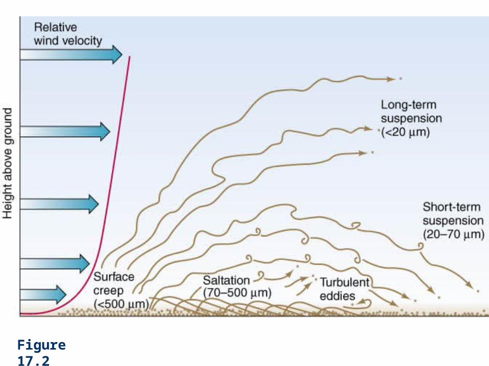
Figure 17.2
Movement of Sediment by Wind (3)
With increasing wind speed, turbulence lifts moving sand grains into the air: this is saltation.
Saltation accounts for at least three-quarters of the sand transport in areas covered by sand dunes.
Sand movement increases rapidly with increasing wind speed.
Sheets of well-sorted sand that have accumulated on the land surface are unstable.

Movement of Sediment by Wind (4)
Saltation moves the smaller, most easily transported grains.
Sand grains too large to be moved are left behind. The coarse grains form a series of small, linear ridges
of sand called sand ripples.

Figure 17.3

Windblown Dust (1)
Fine particles of dust travel faster, longer, and much farther before settling to the ground.
The dustiest places on Earth tend to coincide with some of the world’s major desert regions.
Windblown Dust (2)
Many types of terrain give rise to large quantities of dust:
Dry lakes. Stream beds. Alluvial fans. Outwash plains of glacial streams. Regions underlain by deposits of windblown dust that have
lost their vegetation cover.

Windblown Dust (3)
As a result of frictional drag, the velocity of moving air decreases sharply near the ground surface.
Right at the surface lies a layer of relatively quiet air less than 0.5 mm thick, within which airflow is smooth and laminar rather than turbulent.

Figure 17.5
Windblown Dust (4)
Sand grains that protrude above this layer of quiet air can be swept aloft by rising turbulent eddies.
Dust constitutes the wind’s suspended load. In most cases suspended sediment is deposited
fairly near its place of origin.

Windblown Dust (5)
However, strong winds associated with large dust storms are known to carry very fine dust into the upper atmosphere, where it can be transported thousands of kilometers.
Dust storms are most frequent in the vast arid and semiarid regions of central Australia, western China, Russian central Asia, the Middle East, and North Africa.

Figure 17.6

Windblown Dust (6)
In the United States, blowing dust is especially common in the southern Great Plains and in the desert regions of California and Arizona.

Deposition of Dust (1)
Windborne dust can be deposited under several conditions: Wind velocity and air turbulence decrease so that
particles can no longer remain in suspension. The particles collide with rough or moist surfaces that
trap them. The particles accumulate to form aggregates, which
then settle out because of their greater mass. The particles are washed out of the air by rain. Vegetated landscapes reduce wind velocity.

Deposition of Dust (2)
Deposition occurs where a topographic obstacle causes a reduction of wind velocity.
Deposits of dust are generally thick on the lee, or downwind, side of obstacles.
Deposits of dust are thin or absent on the windward, or upwind, side.

Figure 17.7

Figure 17.8

Detrimental Effects of Windblown Sediment (1)
Crops and other vegetation can be severely damaged.
Engines of vehicles can be ruined. Reduced visibility on roads can cause accidents. Inhalation of dust can cause emphysema. Quartz inhalation can lead to silicosis.

Detrimental Effects of Windblown Sediment (2)
Deadly germs, such as anthrax and tetanus, can be transported in windblown dust.
In central China, a close correlation has been found between deaths due to cancer of the esophagus and the distribution of dust deposits.

Wind Erosion
Erosion is important wherever winds are strong and persistent.
Flowing air erodes in two ways: Deflation: the wind picks up and carries away sand
and dust. Abrasion: wind-driven grains of sediment impact
rock.

Deflation (1)
Nondesert sites where deflation occurs include: Ocean beaches. Shores of large lakes. The floodplains of large glacial streams.
Deflation may occur seasonally when farmland is plowed. Especially severe during times of drought, when no
moisture is present to hold soil particles together.
Deflation (2)
In the dry 1930s, deflation in parts of the western United States amounted to 1 m or more within only a few years.
Deflation hollows and basins are small saucer- or trough-shaped hollows created by wind erosion.
Most are less than 2 km long and only a meter or two deep.

Deflation (3)
The immense Qattara Depression in the Libyan desert of western Egypt lies more than 100 m below sea level due to intense deflation.
The depth to which deflation can reach is limited by water table. As deflation lowers the land, the surface soil becomes
moist, encouraging the growth of vegetation.

Deflation (4)
When sand and dust are either blown away from a deposit of alluvium or locally removed by sheet erosion, stones too large to be moved become concentrated at the surface.
Eventually, a continuous cover of stones forms a desert pavement.

Figure 17.9

Figure 17.10
Abrasion
Abrasion occurs when rock is scoured by windborne grains of sediment.
Results include distinctive rock shapes called ventifacts. A ventifact is any bedrock surface or stone that has
been abraded and shaped by windblown sediment. The common landforms of some desert regions is
an elongate, streamlined, wind-eroded ridge called a yardang.

Figure 17.11
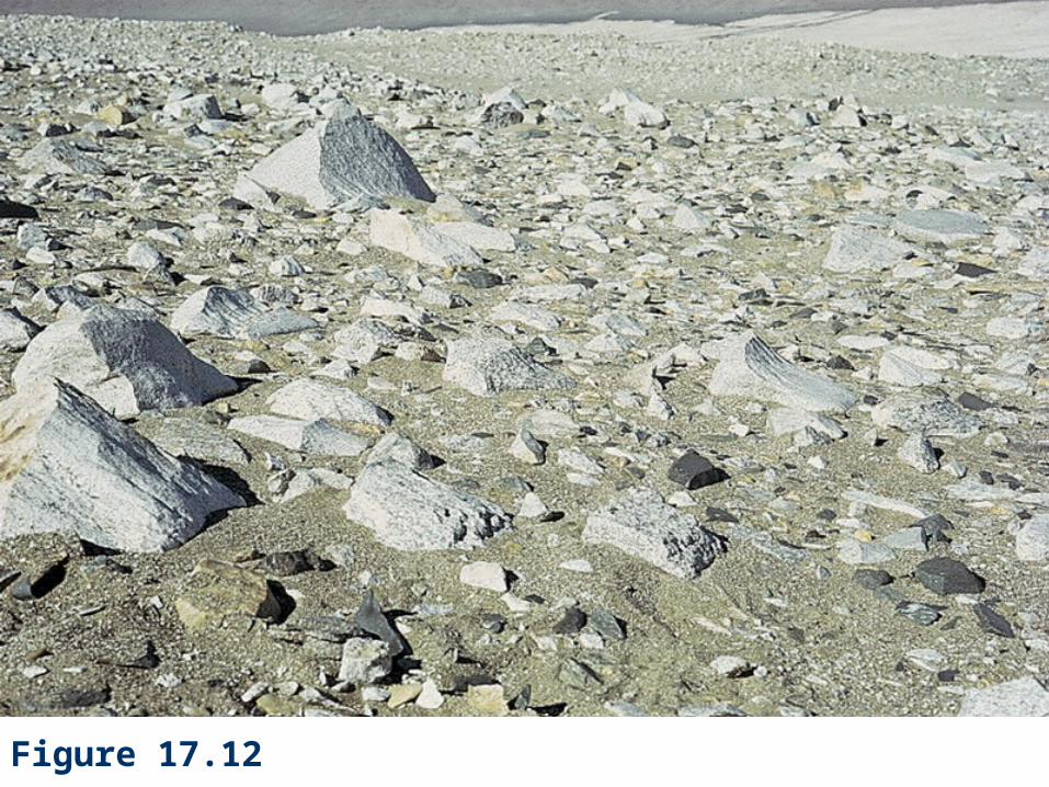
Figure 17.12

Figure 17.13

Eolian Deposits
Sediments deposited by wind are called eolian deposits.
The major kinds of eolian deposits are: Dunes. Loess. Dust in oceans. Glacial sediments. Volcanic ash deposits.
Dunes (1)
A dune is a hill or ridge of sand deposited by winds.
A typical isolated dune: Is asymmetrical. Has a gently sloping windward face (angle of repose: 33-34o).
The lee face of an active dune is called the slip face.
Dunes (2)
The angle of the windward slope of a dune varies with wind velocity and grain size but is always much less than that of the slip face.
This asymmetry of form provides a means of telling the direction of the wind that shaped the dune.
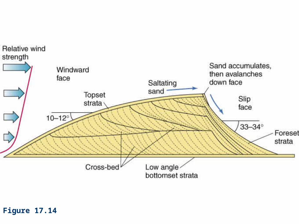
Figure 17.14
Dune Types
There are five different types of dunes:1. Barchan dune.
2. Transverse dune.
3. Linear dune.
4. Star dune.
5. Parabolic dune.

Figure T17.1
– Barchan dune.
– Transverse dune.
– Linear dune.
– Star dune.
– Parabolic dune.
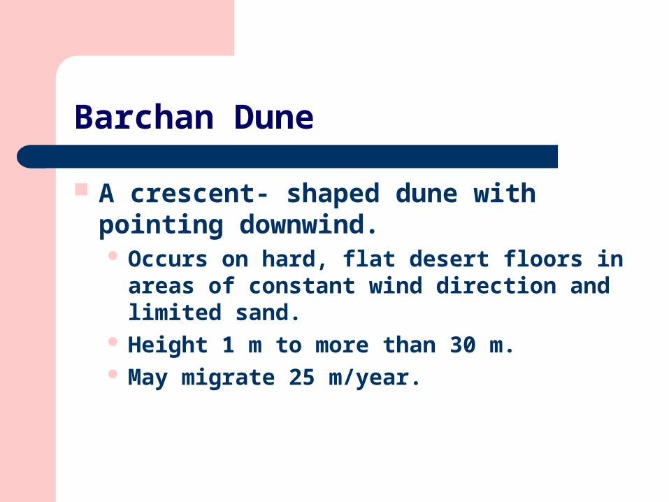
Barchan Dune
A crescent- shaped dune with pointing downwind. Occurs on hard, flat desert floors in areas of constant
wind direction and limited sand. Height 1 m to more than 30 m. May migrate 25 m/year.
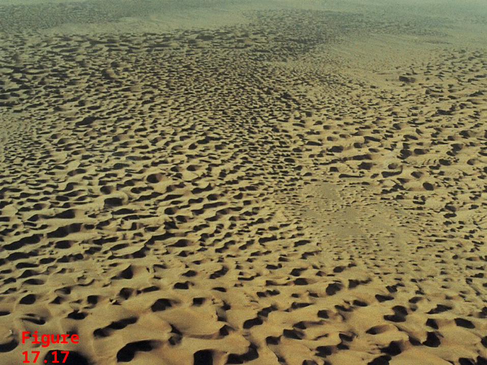
Figure 17.17

Transverse Dune
A dune forming an asymmetrical ridge transverse to dominant wind direction. Occurs in areas with abundant sand. Can form by merging of individual barchans.

Linear Dune
A long, relatively straight, ridge-shaped dune. Occurs in desert with limited sand supply where
winds are variable (bi-directional). Slip faces change orientation as wind shifts direction.

Star Dune
An isolated hill of sand having a base that resembles a star in outline. Sinuous arms of dune converge to form central peak
as high as 300 m. Tends to remain fixed in place in areas where wind
blows from all directions.

Parabolic Dune
A dune shaped like a U or V, with the open end facing upwind. Trailing arms. Generally stabilized by vegetation. Common in coastal dune fields.

Sand Seas
Sand seas are vast tracts of shifting sand. Found in northern and western Africa, the Arabian
Peninsula,and the large desert of western China; Contain a variety of dune forms.
Loess
Loess is wind-laid dust consisting largely of silt. Important resource in countries where it is thick and
widespread because it provides rich agricultural lands.
Upper Mississippi Valley. The Columbia Plateau of Washington State. The loess Plateau region of central China. Much of eastern Europe.
Characteristics of Loess (1)
Loess has two characteristics that indicate that it was deposited by the wind:
1. It forms a rather uniform blanket over hills and valleys alike.
2. It contains fossils of land plants and air-breathing animals.

Characteristics of Loess (2)
Typical characteristics of Loess: Homogeneous. Lacks stratification. Can form vertical cliffs.

Origin of Loess (1)
2 principal sources of loess are: Deserts. Floodplains of glacial meltwater.
The loess that covers central China was blown from the great desert basins of central Asia. Part of the sediment may have come from the
breakdown of rock by frost action and glacial processes in the high glaciated mountains of inner Asia.

Origin of Loess (2)
Glacial loess is widespread in the middle part of North America, and in east-central Europe. The shapes and compositions of its particles resemble
the fine sediment produced by the grinding action of glaciers.

Figure 17.18

Origin of Loess (3)
Glacial loess is thickest downwind from former large braided meltwater streams such as: The Mississippi. The Missouri. The Rhine. The Danube.

Figure 17.19

Dust in Ocean Sediments and Glacier Ice (1)
Dust blown over the ocean forms an important component of deep-sea sediments.
Deposits of eolian dust trend: Eastward across the North Pacific from China. Westward across the subtropical North Atlantic from
Africa. Westward into the Indian Ocean from Australia.

Figure 17.20

Dust in Ocean Sediments and Glacier Ice (2)
Fine particles of quartz deflated from Asian deserts have been found in soils of the Hawaiian Islands.
Windblown dust is also found in cores drilled through polar ice sheets and low-latitude mountain glaciers.

Dust in Ocean Sediments and Glacier Ice (3)
Large quantities of tephra can be ejected into the atmosphere during explosive volcanic eruptions.
A distinctive igneous mineralogy and tiny fragments of volcanic glass make tephra layers easy to recognize.

Dust in Ocean Sediments and Glacier Ice (4)
Fine ash that reaches the stratosphere may circle the Earth many times before it finally settles to the ground.
Eruptions commonly form elongate plumes of sediment that decrease in particle size and thickness downwind from the source volcano.
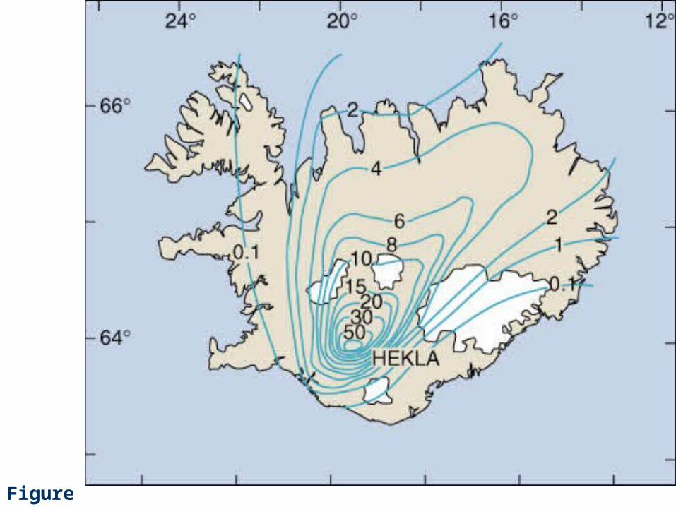
Figure 17.21
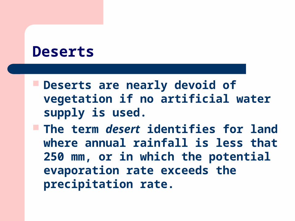
Deserts
Deserts are nearly devoid of vegetation if no artificial water supply is used.
The term desert identifies for land where annual rainfall is less that 250 mm, or in which the potential evaporation rate exceeds the precipitation rate.

Types and Origins of Deserts (1)
Desert lands total about 25 percent of the Earth’s land area.
Five types of desert are recognized: Subtropical. Continental. Rainshadow. Coastal. Polar.
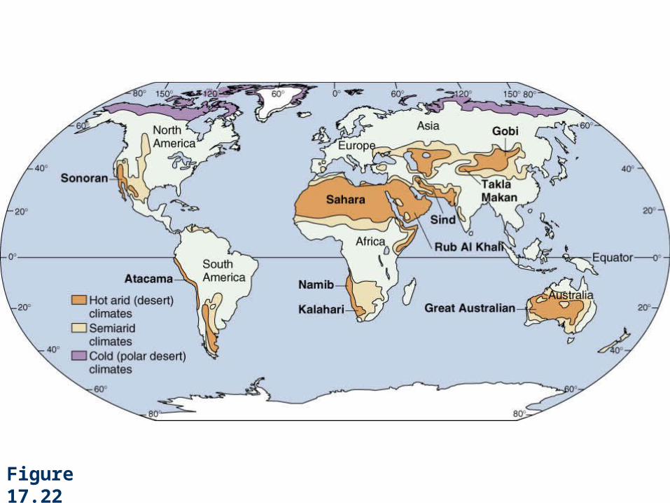
Figure 17.22
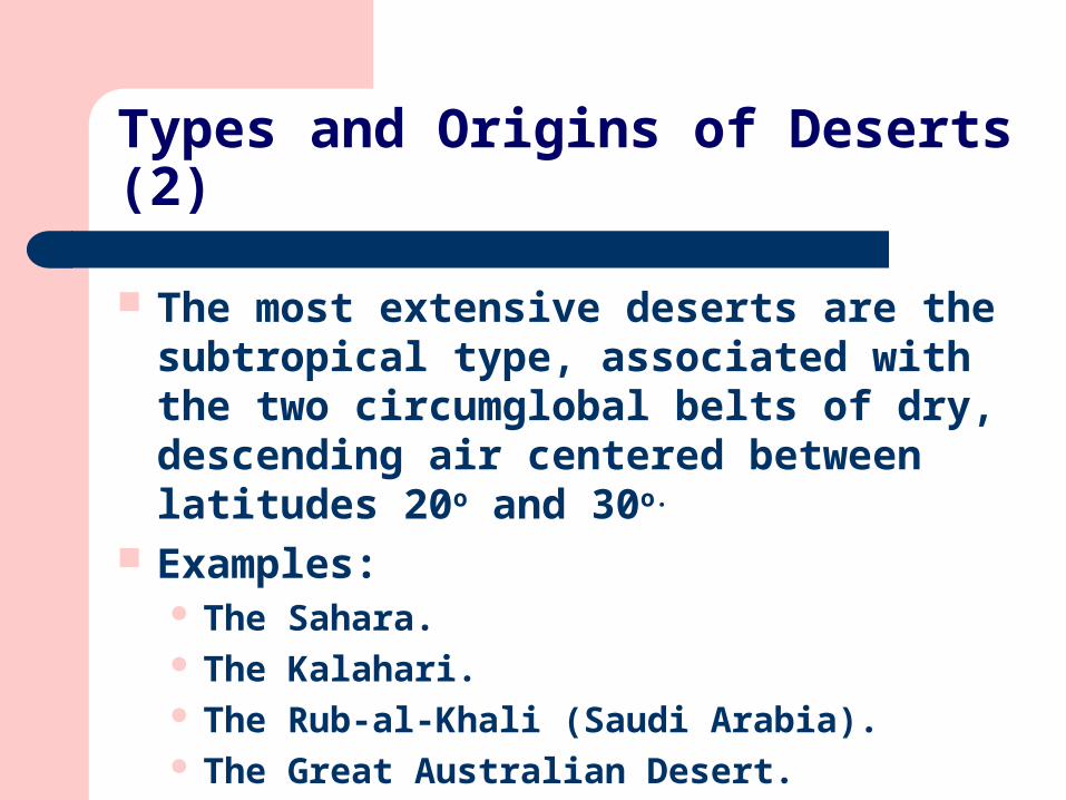
Types and Origins of Deserts (2)
The most extensive deserts are the subtropical type, associated with the two circumglobal belts of dry, descending air centered between latitudes 20o and 30o.
Examples: The Sahara. The Kalahari. The Rub-al-Khali (Saudi Arabia). The Great Australian Desert.
Types and Origins of Deserts (3)
Continental deserts are found in continental interiors, far from sources of moisture.
Polar deserts have extremely low precipitation due to the sinking of cold, dry air. The surface of a polar desert is often underlain by
abundant water, but nearly all in the form of ice. Polar deserts are found in northern Greenland, artic
Canada, and in the ice-free valleys of Antarctica.

Types and Origins of Deserts (4)
Where a mountain range creates a barrier to the flow of moist air, it produces a rainshadow, on the lee side of mountains.
Coastal deserts occur along the margins of continents, where cold upwelling seawater cools maritime air flowing onshore. This decreases the air’s ability to hold moisture.

Desert Climate
The arid climate of a hot desert results from the combination of: High temperature. Low precipitation. High evaporation rate.
Other characteristics: Irregular rainfall. Strong winds.
Surface Processes and Landforms in Deserts (1)
The regolith in a desert is thinner, less continuous, and coarser in texture.
Much of the regolith is the product of mechanical weathering.
Chemical weathering is greatly diminished because of reduced soil moisture.

Surface Processes and Landforms in Deserts (2)
In deserts, because particles created by mechanical weathering tend to be coarse, slopes are generally steeper and more angular.
Among the most distinctive landforms in deserts are: A butte (erosional remnant carved from resistant,
flat-lying rocks units). A flat-topped mesa (wider landform of the same
origin).
Surface Processes and Landforms in Deserts (3)
In many desert areas, older deposits are darker because of desert varnish (a thin, dark, shiny coating, commonly manganese oxide).

Desert Streams and Associated Landforms (1)
Most streams that flow into deserts from adjacent mountains never reach the sea. They soon disappear as the water evaporates or soaks
into the ground. Exceptions are long rivers like the Nile.
A major rainstorm is likely to be accompanied by a flash flood (a sudden, swift flood that can transport large quantities of sediment).

Desert Streams and Associated Landforms (2)
The debris from flash floods forms fans at the base of mountain slopes and on the floor of wide valleys and basins.
Alluvial fans are common in arid and semiarid lands, where they typically are composed of both alluvium and debris-flow deposits. Entire cities have been built on alluvian fans or fan
complexes (for example, San Bernardino, California, and Tehran, Iran).
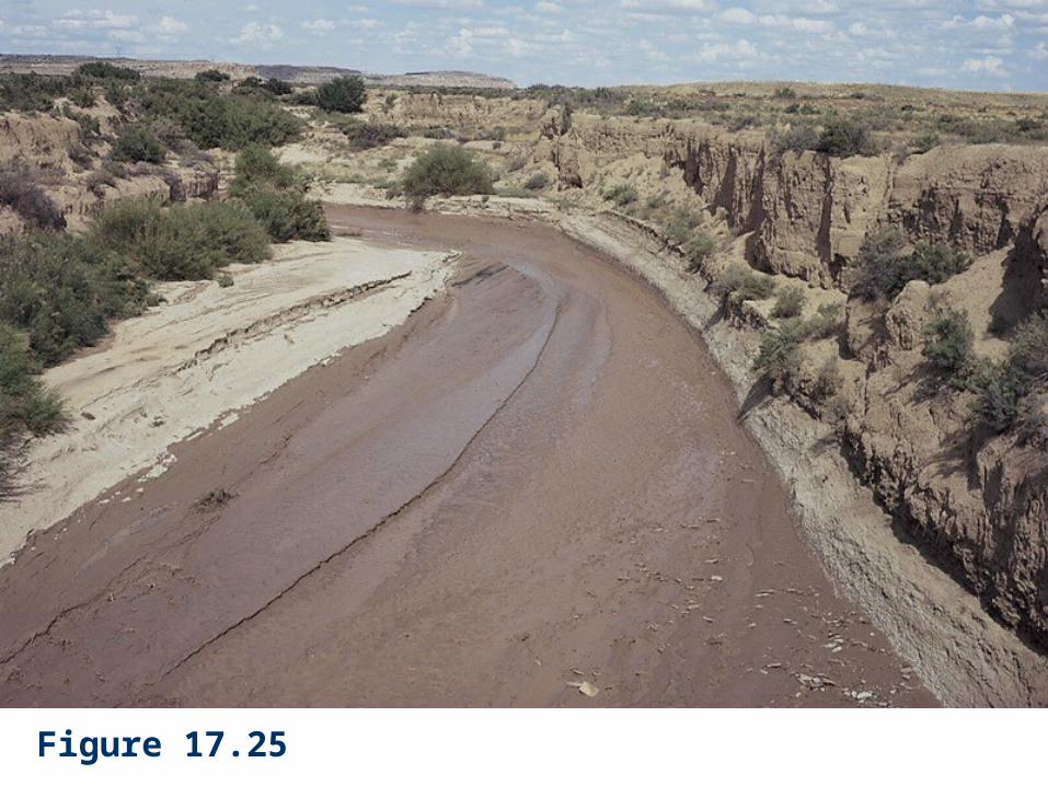
Figure 17.25

Desert Streams and Associated Landforms (3)
Where a mountain front is straight and its canyons are widely spaced, each fan will encompass an arc of about 180o.
If canyons are closely spaced along the base of a mountain range, coalescing adjacent fans form a broad alluvial apron, or bajada.

Desert Streams and Associated Landforms (4)
Runoff in arid regions is rarely abundant enough to sustain permanent lakes.
The floor of a desert basin may contain a dry lakebed called a playa.
Runoff may be sufficient to form a temporary playa lake that will last up to several weeks.

Desert Streams and Associated Landforms (5)
One of the most characteristic landforms of dry regions is the pediment, a broad, relatively flat surface, eroded across bedrock.
A pediment is a bedrock surface rather than a thick alluvial fill.
The long profile of a pediment, like that of an alluvial fan, is concave upward, becoming progressively steeper toward a mountain front.

Figure 17.28
Desert Streams and Associated Landforms (6)
Steep-sided mountains, ridges, and isolated hills that rise abruptly from adjoining plains like rocky islands standing above the surface of a broad flat sea are called inselbergs (German for island mountain).
Inselbergs form in areas of relatively homogeneous resistant rock that are surrounded by rocks more susceptible to weathering.

Desertification (1)
In the region south of the Sahara lies a belt of dry grassland known as the Sahel (rainfall is normally only 100 to 300 mm).
In the early 1970s, the drought-prone Sahel experienced the worst drought of the twentieth century. For several years in succession the annual rains failed to appear,
causing adjacent desert to spread southward (as much as 150 km).
The drought affected a population of at least 20 million people, many of them seminomadic herders of cattle, camels, sheep, and goats.
Desertification (2)
Overgrazing during years of drought killed most of the vegetation. Without vegetation, soil blows away and the desert advances.

Figure 17.31

Figure 17.32

Figure 17.B02