chapter 2 framework for water and sewer planning
TRANSCRIPT

ADOPTED 2018 WATER AND SEWER PLAN
Chapter 2, Framework for Water and Sewer Planning 2- 1
CHAPTER 2 FRAMEWORK FOR WATER AND SEWER PLANNING
A water and sewer service network is important in managing and directing development in
the County. Urban development requires community or multi-use water and sewer service; urban growth is directly dependent on expansion of this service. On the other hand, individual water supply and septic systems, as well as shared facilities, can only support relatively low-density development. Water and sewer management that provides for adequate water supplies, healthy drinking water and appropriate sewage disposal methods promotes public health and environmental quality.
Water and sewer systems provide the basic building blocks for a modern, growing and
environmentally healthy community. Water and sewer planning is critical to the staging and promotion of orderly growth of communities and the prevention of urban sprawl. Therefore, water and sewer planning must be based on consideration of geographical features and environmental factors, community needs as expressed in the County's land use and development policies, Federal and State policy guidance, and public health requirements.
The contextual framework for water and sewer planning includes the natural environment, community planning and development, and legal requirements. These parameters are discussed in more detail in this chapter. 2.1 POLICIES AND PROCEDURES FOR WATER AND SEWER PLANNING The State of Maryland requires every County to develop a Water and Sewer Plan to ensure that there is adequate public water and sewer for planned development. Since the public drinking water supply is a precious resource, the County must plan to provide this supply for its residents in a comprehensive and staged manner. One aspect of the Plan is the designation of every piece of property into service categories used to stage development.
Pursuant to State Law, each County and all municipalities governed by the Land Use Article must prepare a comprehensive water resources element (WRE) plan. This Water and Sewer Plan will be amended to address the policies contained in the 2010 Approved Water Resources Plan. As part of the water resources plan element being developed by the County, an assessment will be made of the adequacy of each aquifer in the County, its capacity to accommodate future growth and the impact of development in adjacent counties. 2.1.1 Sewer Envelope The Sewer Envelope is depicted on the Category Maps as a boundary beyond which no community water and sewer facilities will be approved. The Sewer Envelope boundary is based on topography, existing sewer service areas, and proposed development density according to the General Plan and the Area Master Plans. The Sewer Envelope boundary was established in 1994. The County Council reaffirmed the envelope boundary by adopting it as the template for the Rural Tier boundary adopted in the Commission 2000 Biennial Growth Policy Plan and the 2002 General

ADOPTED 2018 WATER AND SEWER PLAN
Chapter 2, Framework for Water and Sewer Planning 2- 2
Plan. Plan Prince George’s 2035, adopted in 2014, approved several areas from the Rural Tier to the Growth Tier that will require amending the boundary for consistency and compliance with the General Plan. The Sewer Envelope serves to encourage growth in communities where water and sewer services are approved and are sufficient for handling this growth. The Sewer Envelope, as it is known, was based on the County’s topography and drainage into sewer basins. While it remains the Sewer Envelope, it encompasses both water and sewer service categories. By defining a geographic boundary in which public water and sewer service can be provided, it also serves to preserve the County’s rural, agricultural, and environmentally sensitive lands. Shared septic facilities and innovative technologies are encouraged in sensitive areas, especially outside the Sewer Envelope. Provisions for the use of these facilities may be found under “Strategies” outlined in Policy 12 of the Rural and Agricultural Areas of the General Plan. Applicable County policies on rural sanitation, individual systems, and shared facilities are described in Chapter 5. Adjustments of the Sewer Envelope boundary may only be achieved through a master plan, sector plan or general plan process and approved by the County Council. A property’s location in proximity to the boundary is not, in itself, justification for changing the boundary. There are many factors that contribute to the decision to retain or modify the Sewer Envelope boundary, including consistency with the General Plan. Each factor must be thoroughly reviewed against criteria that were used in establishing the Sewer Envelope and new criteria for determining compatibility with other County growth policies. Map 2-1 reflects the Sewer Envelope boundary consistent with the General Plan Growth Boundary, and the prevailing sewer (and water) service categories. The General Plan Growth Policy map – from which the Sewer Envelope boundary is revised for consistency thereto– may be found in the Community Planning Framework section of this chapter. 2.1.2 Water and Sewer Categories
Water and sewer categories represent different planning levels for the provision of public water and sewer service. Prince George's County has been using water and sewer categories, also known as "service areas" and "system areas", since the adoption of its first Comprehensive Water and Sewer Plan in 1977. The process of changing categories allows public water and sewer service to be staged according to development proposals, and assures high quality development by the landowner consistent with County policies.
The policy of linking water and sewer categories to stages of the development process assures that the water and sewer systems will expand appropriately to reach new development as it comes on line. Conversely, this system assures that when new developments are built, adequate water and sewer service will be available. The County Executive is charged with ensuring that this process is done in accordance with the goals, objectives and legal authority granted Prince George’s County under the State Environment Article.

Map 2-1Sewer Envelope Boundary Prince George's County Maryland
Document Name: Sewer Envelope Boundary.
THIS MAP MAY NOT BE REPRODUCED, STORED IN A RETRIEVAL SYSTEM, OR TRANSMITTED IN ANY FORM, INCLUDINGELECTRONIC OR BY PHOTO REPRODUCTION, WITH OUT THE EXPRESSED, WRITTEN PERMISSION OF THE DEPARTMENT OF
Legend
Howard County
Montgomery County
District of Columbia
District of Columbia
Potomac River
Patuxent River
Anne Arundel County
Charles County
WaterLand
Land_TypePG County
S-6P Private, Shared or Community SystemS-6 Individual System
S-5 Future Community SystemS-4 Community System Adequate for Development PlanningS-3 Community System
Water_Sewer
MAJORROADS
Envelope
AË
AÌ
AÑ
K²
I|
AÑ
AÉ
AÔ
AÍ
AÏ
Io
?¼
AÊ
!"d$
AÌ
?½
%&k(
!"d$
K²
AÌ
I|
Aè
AÈ
AÎ
Io
AÆ
%&h(
0 2 4 6 81
Miles
:

ADOPTED 2018 WATER AND SEWER PLAN
Chapter 2, Framework for Water and Sewer Planning 2- 4
To facilitate the orderly extension of community water and sewer service, State regulations
(COMAR 26.03.01.04) have established six category designations for water and sewer service areas. Prince George’s County has modified the State’s category definitions to more accurately reflect the planning needs of the County. These determine where public water and sewer service is or will be available (Categories 3, 4, and 5) and where private well and septic systems must be used (Category 6). Under State regulations, Categories 1 and 2 refer to existing service areas or areas with approved connections or extensions, via the Washington Suburban Sanitary Commission (WSSC). Prince George’s County has included these properties in Category 3. Category designations inside the Sewer Envelope reflect planning stages for the public water and sewer system(s). Monitoring the expansion of water and sewer service is the most effective way to manage and phase growth. Therefore, the County uses the following water and sewer categories for the staging of development and its processes: Category 3 Community System Category 4 Community System Adequate for Development Planning Category 5 Future Community System Category 6 Individual Systems - Well and Septic Systems or Shared Facilities Category 6P Private, Shared/Community System It is necessary to know a property’s water and sewer category to determine whether to develop using public water and sewer, or individual wells and septic systems. Properties are usually designated in the same category for both water and sewer service. The water category map and the sewer category map are included as appendices to this Plan. Amendment processes and the criteria for re-designation are discussed further in Section 2.1.4 and in Chapter 6. The following water and sewer categories further define usage as designated on the maps in Prince George’s County: Category 6. Individual Systems. This category consists of all areas outside the limit of planned water and sewer service (Sewer Envelope), and of certain larger tracts of parkland and open space inside the Sewer Envelope. Development in Category 6 must use permanent individual water supply and wastewater disposal systems (i.e., well and septic systems) or shared facilities and smaller community systems (Category 6P) as approved by the County (see Section 5.2.3 in Chapter 5). Re-designation to and from Category 6 or 6P must proceed through a legislative amendment process (see Chapter 6). Category 5. Future Community System. This category consists of land inside the Sewer Envelope that should not be developed until water and sewer lines are available or planned to serve proposed development, its community, as needed to meet growth projections, or when additional residential capacity is required. Properties in Category 5 require a re-designation to Category 4 prior to the approval of a preliminary plan of subdivision, having first demonstrated its ability to meet the aforementioned criteria. Minor residential developments may be approved for the use of interim individual systems in certain circumstances. This is known as the “Waiver” process (see Chapter 6).

ADOPTED 2018 WATER AND SEWER PLAN
Chapter 2, Framework for Water and Sewer Planning 2- 5
Redesignation requests from Category 5 to Category 4 must proceed through a legislative amendment to the Water and Sewer Plan (see Chapter 6). Category 4. Community System Adequate for Development Planning. This category includes all properties inside the Sewer Envelope for which the subdivision process is required. Redesignation from Category 4 to Category 3 may be requested through the Administrative Amendment process. In addition to the final plat requirements, the redesignation will require that (1) the development proposal is consistent with the County's development policies and criteria (Section 2.1.4) and the State Growth Act; (2) adequate capacity exists; and (3) the projects for necessary system improvements are included in the approved WSSC Capital Improvement Program (CIP). Inconsistencies or inadequacies with the above criteria shall be eliminated prior to redesignation to Category 3. Category 3. Community System. This category comprises all developed land (platted or built) on public water and sewer, and undeveloped land with a valid preliminary plan approved for public water and sewer. The expiration of a preliminary plan reverts the property to Category 4 even if the maps have not been amended to reflect the change. In instances where the change has not been effected, DPIE will indicate these properties to be “Dormant Category 3”. At the time of preliminary plan review, DPIE will verify that a property shown on the maps in Category 3, in fact meets the stated criteria (i.e., developed land, platted or built on public water and sewer, and undeveloped land with a valid preliminary plan approved for public water and sewer). If not, the property is considered to be in Category 4, being designated “Dormant Category 3” on the Water and Sewer Maps, and will follow the Administrative Amendment process for renewal of Category 3. Individual water supply and wastewater disposal systems may not be approved for properties in Category 3 unless special circumstances exist (see Chapter 6, Waiver Process).
2.1.3 Water and Sewer Category Maps The Water and Sewer Plan adopts redrafting of the County’s Water and Sewer Category Maps in accordance to legislative and administrative amendments and in consistency with the approved General Plan and amendments. The Category Maps are prepared using the County’s Geographic Information System (GIS). The 2018 maps are based on the Adopted 2008 Water and Sewer Category Maps and all category change amendments approved since CR-91-2008, and impact of changes as a consequence of the approval of Plan 2035. DPIE is the delegated authority to determine the validity of any subsequent challenges to the maps. The adoption of the 2018 Water and Sewer Category Maps reflects the following:

ADOPTED 2018 WATER AND SEWER PLAN
Chapter 2, Framework for Water and Sewer Planning 2- 6
1. All property outside the Sewer Envelope boundary is designated in Category 6 (dark green hue
on the category maps) except certain parcels approved for and connected to public water or sewer service prior to the adoption of this Plan. These properties are listed in Appendix 2-1 of this Chapter. Properties approved for shared community systems, outside the Sewer Envelope, are shown outlined on the water and sewer maps (Category 6P).
2. All property located inside the Sewer Envelope is designated in Category 5, 4 or 3 with the
exception of certain larger tracts of open space, generally parks and cemeteries. 3. Administrative and technical mapping changes and corrections of drafting errors, including
changes to incorporate the adoption of Subregion plans that may not have been affected by the prior versions of the Prince George’s County Water and Sewer Category Maps.
Properties referenced above are listed in Appendices 2-1, and 2-2 of this chapter. Small-scale water and sewer category maps are included as appendices to this Plan. Special printouts and larger scale maps may be obtained from DPIE, and follow the applicable fee structure adopted for the Water and Sewer Plan. See Appendix 6-2 for related fee structure.
2.1.4 Category Change Policies and Criteria Based upon its legal authority, Prince George's County has developed special policies to govern water and sewer planning in a manner consistent with the County’s goals for development review. The County Executive and the County Council review these policies, which must be in concert with the County’s goals and objectives and, through a legislative process, amend categories within the adopted Water and Sewer Plan. This is known as the “Category Change” procedure. Executive authority delegates the processing of category amendments to DPIE, which acts as the County’s steward on development and permitting matters and, as the administrator to the Water and Sewer Plan. The policies governing changes to a designated category must take into account environmental factors, economic concerns, planning requirements, regulatory policies, engineering constraints, and public health concerns. An application may be rejected if these policies and criteria are not met unless a hardship in meeting the policies and criteria is demonstrated by the applicant and concurred by the elected body. Specifically, these include: A. Environmental factors
Under this criterion, the proposal must: • Protect the integrity of the water supply and the receiving waters; • Protect natural resources; and • Preserve, protect, and enhance environmental quality.

ADOPTED 2018 WATER AND SEWER PLAN
Chapter 2, Framework for Water and Sewer Planning 2- 7
B. Economics and general fiscal concerns
Under this criterion, the proposal must: • Be analyzed for its fiscal impact related to location, community needs, public facilities,
services and infrastructure. • Correlate with County strategies and not unduly burden the existing taxpayers or the WSSC
ratepayers. • Enhance business, housing, retail development and employment opportunities throughout
the County. C. Planning, zoning, and subdivision requirements
• No Water or Sewer Category Change Request shall be processed or approved for land for which a change in zoning is proposed in:
1. A Sectional Map Amendment transmitted by the Planning Board to the District Council; or
2. A Zoning or Special Exception application pending before the Hearing Examiner or Prince George's County District Council.
Once the District Council has adopted a zoning change, the processing of a water and sewer category change can proceed.
• No Water or Sewer Category Change request shall be processed or approved for properties
designated Category 6 where the following conditions exist: 1. Properties in Water and/or Sewer Category 6 within the defined planning or study
area for which a master, or sector plan, or sectional map amendment, has been initiated by the District Council but not yet adopted/disapproved by the Planning Board and/or District Council.
2. Properties in Water and/or Sewer Category 6 within the defined planning or study area for which a master, or sector plan, or sectional map amendment, has been initiated by the District Council and adopted by the Planning Board, but remanded by the District Council for further Planning Board review.
Applicants may submit Water and/or Sewer Category Change Requests for these properties upon a Planning Board disapproval or District Council approval of a master plan, sector plan, sectional map amendment, or zoning application, if necessary.
• A hydraulic planning analysis (HPA) should be submitted to WSSC prior to submittal of the preliminary plan of subdivision to M-NCPPC.
• All preliminary plans of subdivision must show a conceptual alignment of all proposed onsite and offsite water and sewer facilities before DPIE may deem the public water and sewer facilities adequate and allocated for the proposed development.
• All final plats of subdivision must be approved by DPIE for public water and sewer service, or by the County Health Department for individual well and septic systems.
D. Federal, State, Regional, County and Municipal land use plans and planning policies
Under this criterion, the proposal must conform to governed mandates, policies and ordinances:

ADOPTED 2018 WATER AND SEWER PLAN
Chapter 2, Framework for Water and Sewer Planning 2- 8
• Water and sewer service shall be provided in concert with the availability of other public facilities, and in accordance with the General Plan and applicable Area and Functional Master Plans.
• Water and sewer lines traversing the Rural and Agricultural areas are designated as controlled access facilities and are not available for connection or extension. Controlled access facility lines serve the purpose of transmission to a public entity (Federal, State, Regional, County, and Municipal) or a project that has been granted a Certificate of Public Convenience and Necessity by the Maryland Public Service Commission. Water and sewer lines for extension of service into the rural and agricultural areas of the County may be approved if the following applies:
-An approved Area Master Plan or Sector Plan designates the area for public water and sewer service consistent with the policies in the General Plan or the proposed development has been determined to be compatible with other County growth policies relating to location, community needs, residential capacity, public facilities and other appropriate policies.
• Proposed development in the Growth Policy Areas shall meet existing contiguity policies, and demonstrate:
- Contiguity to existing built developments; - Location within 1,500 feet of existing public water and sewer systems; - Roadways are capable of supporting demands from the proposed development; and, - Require developer(s) to bear the full responsibility of the costs of on- and off-site public facilities. • Proposed development may not hinder the County’s ability to provide adequate public
services to the County and its residents. Adequacy of public facilities shall be measured in accordance with subdivision and zoning ordinances.
• Proposed development shall be analyzed for consistency with the General Plan, master/sector plans, and functional master plans as defined by the land use article of the Maryland Annotated Code. This analysis shall include, but not be limited to, the impact of proposed developments and water and sewer extensions on land use, development patterns, historic sites and districts, public facilities, green infrastructure, and transportation system, including, but not limited to, traffic impacts, road construction needs, sidewalks, pedestrian trails and road connectivity in the surrounding neighborhoods.
E. Water and sewer facility plans, engineering constraints, and the availability of transmission
and treatment capacity • Public water and sewer service extensions shall not be allowed in the area outside the limit
of planned sewer services – also called the Sewer Envelope – unless the project is deemed to be compatible with other County growth policies after an analysis of the impact of the project related to its location, community needs, residential capacity, services, infrastructure, public facilities and other appropriate policies have been evaluated.
• Any proposed use of grinder pumps shall be in accordance with WSSC policy and standards.
• A development proposal must meet any conditions of an allocation policy set for the specific basin or water pressure zone.

ADOPTED 2018 WATER AND SEWER PLAN
Chapter 2, Framework for Water and Sewer Planning 2- 9
• Water and sewer systems must have adequate transmission and treatment capacities to serve the proposed development.
F. The need to alleviate and abate public health problems
• The County’s primary responsibility is to protect public health and safety. • Water and sewer service is restricted by any moratorium orders issued by MDE, WSSC,
or the Federal Government. • No new developments will be approved that may impose a water and sewer moratorium on
the County. • The County Health Department may request a category change for a community based on
findings of a sanitary survey. The County, by its adopted Water and Sewer Plan, has a reasonable expectation that service will be available in accordance with the specific category designation. The designation, however, does not constitute a guarantee, a binding promise, a firm offer or a representation that water or sewer service will actually be provided. It is important to emphasize that the Water and Sewer Plan, as interpreted by the Maryland courts and by its nature as a planning tool, provides considerable flexibility in its implementation to accommodate growth within the County. Furthermore, the ability of the County to provide service must be secondary to the responsibility of the County to protect public health and safety, including the prevention of wastewater overflows and the pollution of the County's waters. The developer must also be aware that actual water and sewer service is further dependent on one or more of the following:
• The transmission and treatment capacities of the water and sewer systems; • Moratorium orders issued by MDE, WSSC, and Federal and State Planning processes; • An extension approval for the project from the WSSC before construction can begin; • The acquisition of any necessary rights-of-way and the completion of engineering
feasibility studies; • The financial ability of the developer or the utility to fund construction of water and
sewer lines; • Land use plans and zoning constraints; • Any defaults by parties contracting with WSSC to construct water and sewer facilities;
and, • The County’s allocation policies, which are discussed below.
2.1.5 Allocations of Capacity In the process of evaluating category change requests, development proposals are reviewed for adequacy of available capacity in the water pressure zone and the sewer basin where the project

ADOPTED 2018 WATER AND SEWER PLAN
Chapter 2, Framework for Water and Sewer Planning 2- 10
is located. The capacity of each sewer basin in Prince George's County is monitored by the WSSC. The WSSC publishes quarterly reports on the available sewer capacity that are reviewed by DPIE and the Health Department. Specific allocation of sewer capacity may be required if the treatment or transmission flows and commitments exceed 90 percent of the capacity in a particular sewer basin. If this occurs, system capacity will continue to be monitored by WSSC and DPIE. Upon notice from WSSC that 90 percent of the capacity is being exceeded in any sewer basin or for another good reason, the County may re-institute a sewer allocation process when deemed necessary for the orderly expansion of the water and sewer system or for the health, safety and welfare of the citizens of the County. For each sewer basin where 95 percent of the capacity has been exceeded, WSSC shall notify DPIE and the Health Department, then WSSC, and DPIE or the Health Department will jointly approve all subsequent record plats. An amendment to the allocation policy must be approved in the Water and Sewer Plan.
2.1.6 Public Use Service Allocations A public use allocation is required for all projects that are undertaken by a public entity (Federal, State, Regional, County or Municipal) and require service connection to the public system. A public use allocation is obtained through the Administrative Amendment approval process described in Chapter 6, Section 6.4. In addition to a public use allocation, the Administrative Amendment process may be used to approve water and sewer category change, water withdrawal point, or point of discharge for certain projects as described below: A. A public project that meets the following criteria:
1. The project is in the adopted Capital Improvement Program of the Prince George’s County Government, the M-NCPPC or WSSC;
2. The project description states that public water and sewer service is required for project implementation; and 3. The proposed project site is clearly identified.
B. A project that has been granted a Certificate of Public Convenience and Necessity by the Maryland Public Service Commission.
C. A project that is undertaken by any County public safety agency, and is wholly or partially
funded through the adopted Operating Budget of the Prince George’s County Government.

ADOPTED 2018 WATER AND SEWER PLAN
Chapter 2, Framework for Water and Sewer Planning 2- 11
2.1.7 Relationship to Other Development Review Processes
The development review process includes consideration of environmental factors, the cost of public investments to support development, and the need to improve the County's community environment while strengthening its economic position. When implemented in conjunction with a master plan and zoning map amendment, these efforts allow for a comprehensive and cohesive process that discourages haphazard and piece-meal development. Water and sewer planning is coordinated with other development review processes in the County. Listed below are the more common development review processes that are linked to water and sewer planning. Water and sewer service categories used are described in more detail in Section 2.1.2 of this Chapter. A. Zoning. DPIE accepts applications to amend the Water and Sewer Plan only when the
development proposal for the subject property is in conformance with current zoning, including applicable Special Exceptions. Prior to approval, Zoning Amendments and Special Exceptions must be reviewed for conformance with the Water and Sewer Plan.
B. Preliminary Plan of Subdivision. Subdivision of properties in water and sewer service
Category 6 must be based on individual wells and septic systems. Development plans based on public water and sewer service must be designated in water and sewer service Category 4 or 3, and must display a conceptual alignment of onsite and offsite water and sewer facilities, before a preliminary plan of subdivision can be approved. A hydraulic planning analysis (HPA) should be submitted to WSSC prior to submittal of the preliminary plan of subdivision to M-NCPPC.
C. Site Development Concept Plan Review (formerly known as Stormwater Management
Concept). An approved Site Development Concept Plan is required prior to approval of water and sewer service Category 3.
D. Water and Sewer System Expansion Permit (SEP) Extensions. Water and sewer service
Category 3 and allocation, if applicable, must be approved before the WSSC can approve an extension of public water and sewer service. A WSSC approval of a HPA is required for recordation of a final plat if water and sewer service requires the extension of existing lines.
E. Recordation of Final Plats. A final plat of subdivision based on public water and sewer
service can be recorded after DPIE certifies that the subject property is in Category 3 and has an allocation, if applicable. It must also certify that water and sewer lines either abut all of the lots to be recorded, or that WSSC has approved an extension of service and has notified DPIE of such action through a WSSC Letter of Findings that includes a sketch of necessary extensions.

ADOPTED 2018 WATER AND SEWER PLAN
Chapter 2, Framework for Water and Sewer Planning 2- 12
2.2 NATURAL ENVIRONMENT
Among the geographical and environmental factors to be considered in planning water and sewer facilities, are the drainage patterns, soils, aquifers, and surface waters with associated floodplains and wetlands. These factors determine availability of water, feasible transmission patterns for both water and sewer, and percolation characteristics. The natural environment also sets a framework for development. In 2017 Prince George's County adopted the Resource Conservation Plan, a Countywide Functional Master Plan that combines the related elements of green infrastructure planning and agricultural and rural conservation to support a platform for sustainable growth. The plan identifies the green infrastructure network, and sets goals for the preservation, enhancement, and restoration of the network and its ecological functions while supporting the desired development pattern of the General Plan. The green infrastructure network is established with two categories: countywide Regulated Areas and Evaluation Areas. The countywide Regulated Areas contain environmentally sensitive features, such as streams, wetlands, buffers, the 100-year floodplain, and adjacent steep and severe slopes. The areas identified as Network Gaps on the 2005 Green Infrastructure network map are not identified on the 2017 GI network map because the new network is too complicated to identify network gaps at the countywide scale. Network gaps will be identified using one of two methods in the future: (1) when master and sector plans are prepared, the GI network boundaries can be adjusted as needed and Network Gaps can be identified; and (2) when development applications are reviewed for areas where Network Gaps have not been identified. The plan also designates 13 Special Conservation Areas of the countywide significance that are to be carefully considered when land development proposals are reviewed. The Green Infrastructure Plan is used as a guide by decision-makers when making land use and acquisition decisions and contains policies and strategies to preserve, protect, enhance and restore the green infrastructure network and its ecological functions. Master plans and sector plans can also designate special conservation areas of local significance or add areas to the designated green infrastructure network that are of local significance. These locally significant features are also considered with land development proposals.
The General Plan provides an annual target for land conservation countywide of 1,500 acres. All types of land conservation programs are included in the goal, as are the acres of woodlands preserved and planted as a result of implementation of the Woodland and Wildlife Habitat Conservation Ordinance. The Green Infrastructure plan provides guidance regarding targeted woodland preservation to protect waterways and support a contiguous forest. Sector and area plans as well as Sections 5B, 24, 25, 27, and 32 of the Prince George’s County Code contain regulations, objectives and strategies for land conservation.
2.2.1 Physiography, Topography, Drainage and Wetlands Prince George's County is mostly in the physiographic province called the Atlantic Coastal Plain, but a small area along the Montgomery County line is in the Piedmont province. The Piedmont is underlain by crystalline rocks of pre-Cambrian age. It is gently rolling to hilly and moderately dissected by broad, shallow valleys. The Atlantic Coastal Plain is underlain by

ADOPTED 2018 WATER AND SEWER PLAN
Chapter 2, Framework for Water and Sewer Planning 2- 13
deposits of gravel, sand, silt and clay that range in age from Cretaceous in the northern part of the County to Recent Alluvium on the floodplains. The northern part of the Coastal Plain in Prince George's County is gently rolling and has broad valleys. The rest is a partly dissected low plateau that extends into Charles County. In the central part of the County, this plateau is nearly level to gently sloping, but near the Patuxent and Potomac Rivers, it is cut by V-shaped valleys that have short, steep slopes. Old alluvial terraces border the Patuxent and Potomac Rivers. Elevations range from sea level along the lower reaches of the major rivers to 365 feet in the northern part of the County. Slopes of 15 percent or greater comprise almost 43,000 acres or 14 percent of the total land area of the County (see Map 2-2). Approximately half of Prince George's County drains eastward into the Patuxent River; the remainder drains southwestward through the Anacostia River and other streams to the Potomac River. Map 2-3 delineates the watersheds. The major tributaries of the Potomac River are the Anacostia River, Oxon Run, Henson Creek, Piscataway Creek, Mattawoman Creek and Zekiah Swamp. The largest of these, the Anacostia, has tributaries of its own. The major tributaries of the Patuxent River are Western Branch, Bear Branch, Mattaponi Creek, Rock Branch and Swanson Creek. Western Branch is the largest of these tributaries. All of the major streams in the County flow at a low velocity under normal conditions. Most are in broad valleys and many have large accumulations of silt. Tidal waters occur where the streams flow into the Patuxent and Potomac rivers, primarily in the southern part of the County. The total area of surface water in the County is 7,000 acres or 2.4 percent.
2.2.2 Soils Water quality is often dependent on the amount of sediment-laden runoff that enters surface waters from agricultural uses and unregulated development activity. In order to protect surface water quality, erodible soils must be managed by using best management practices and sediment controls. Refer to soils and drainage class further within this chapter.
Soils play an important role in determining whether on-site sewage disposal systems (septic systems) can be used. Soils characterized as well-drained are considered conducive for underground sewage disposal. These soil types are commonly found along sloping ground and below the crests of ridgelines and hilltops.
Soils characterized as poorly drained are not considered to be conducive for underground sewage disposal. These soil types are most commonly found on the top of plateaus, on very flat land, and near or at the bottom of ravines, hills or ridgelines. Soils displaying these characteristics often have seasonally high water tables.


ADOPTED 2018 WATER AND SEWER PLAN
Chapter 2, Framework for Water and Sewer Planning 2- 16
The U.S. Department of Agriculture (USDA) Soil Survey written for Prince George's County aids in identifying specific soil types and various limitations associated with them. The Soil Survey also combines several soil series into soil groupings or associations. A soil association is a landscape that has a distinctive pattern of soil. It normally consists of one or more major soils, at least one minor soil, and is named for the major soils.
The soils in one association may occur in another, but in a different pattern. Map 2-4 identifies the soil associations found in Prince George's County. Additional information concerning soils can be found in the USDA Soil Survey for Prince George’s County or by contacting the Prince George’s County Soil Conservation District.
Beltsville-Leonardtown-Chillum association: moderately deep, well-drained to poorly drained, predominantly gently sloping soils that have a compact subsoil, substratum or both.
Bibb-Tidal Marsh association: poorly drained soils of floodplains and tidal marshes that are subject to tidal flooding.
Christiana-Sunnyside-Beltsville association: deep, level-to-steep, well-drained, sandy and clayey soils and level-to-sloping, moderately deep, moderately well-drained soils that have a compact subsoil, substratum or both.
Collington-Adelphia-Monmouth association: deep, nearly level to strongly sloping, well-drained and moderately well-drained soils of the uplands that develop in sediments containing glauconite. Soil in this association has fairly friable subsoil and a friable-to-loose substratum.
Collington-Matapeake-Galestown association: deep, well-drained to excessively drained, nearly level to strongly sloping soils on terraces along the Patuxent River. Soils in this association have fairly friable subsoil and a friable-to-loose substratum. Manor-Glenelg association: deep, well-drained and somewhat excessively drained, nearly level to very steep soils of the Piedmont province. Sassafras-Croom association: gently sloping to steep, well-drained, predominantly gravely soils, some of them with compact subsoil, substratum or both.
Sassafras-Keyport-Elkton association: nearly level to strongly sloping, well-drained to poorly drained soils on terraces along the Potomac River. Westphalia-Evesboro-Sassafras association: deep, well-drained to excessively drained soils of uplands that are mostly moderately sloping to steep. Soils in this association have fairly friable subsoil and a friable-to-loose substratum.


ADOPTED 2018 WATER AND SEWER PLAN
Chapter 2, Framework for Water and Sewer Planning 2- 18
Westphalia-Marr-Howell association: deep, well-drained, nearly level to strongly sloping soils of the uplands. Soils in this association have fairly friable subsoil and a friable-to-loose substratum.
In addition to the soil types identified, there is a deeper geologic formation that places
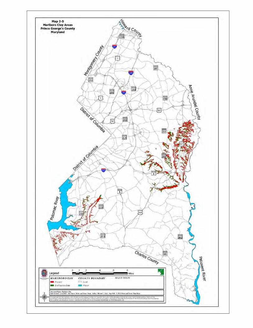
constraints on development in Prince George's County – Marlboro Clay. These soils may slump or slide when bearing the weight of structures, and they are not suitable for effective onsite sewage disposal systems. Areas with Marlboro Clay are shown on Map 2-5. The Coastal Plain sediments underlying Prince George's County frequently contain sulfidic material at some depth. While posing few hazards when left undisturbed, these sulfidic materials exposed to air oxidize fairly rapidly and create conditions that are extremely corrosive to concrete and steel. Geologic formations inherent to Prince George’s County are identified in Map 2-6. The listing below provides descriptions of the identified formations. Additional information on geologic formations may be obtained by contacting the Maryland Department of Natural Resources.
Laurel Formation – Medium to coarse-grained, moderately to well foliated sedimentary mélange consisting of a quartzofeldspathic matrix that contains quartz “eyes” and fragment to blocks of metamorphic rocks which specifically include fragments of meta-arenite and biotitie schist in the mapped area. The rock weather s to a porous, spongy brown saprolite and grades upward to sticky micaceous red and gray clay. Silt-Clay Facies – Clay, silt, and subordinate fine-to medium-grained clayey sand. Red, tan, gray, buff, or mottled; dark-gray, where heavily organic. Sand- Gravel Facies – Interbedded quartz sand, pebbly sand, gravel, and subordinate silt-clay. Sands and gravels typically whit, buff, yellow to brown; weathered zone commonly limonitic with ironstone pods and layers. Silt-clay is white, pale gray, or variegated; dark-gray where highly organic.
Alluvium – Interbedded sand, silt-clay, and subordinate gravel. Light-to dark-gray, tan, or brown; weathers pale-gray, yellow, or brown.
Terrace Deposits – Interbedded sand, gravel and silt-clay. Typically tan, brown, or shades of gray; weather to yellow, orange, or brown hues, commonly limonitic.
Brightseat –Severn Formations, undivided – Sand and silt, clayey in part, variably glauconitic. Dark-gray to dark greenish gray; weathering pale-gray to brownish gray.
Severn Formation – Sand, fine-grained, variably glauconitic. Pale-gray to medium-gray; weathering mottled pale-gray and yellow.
Aquia Formation – Sand, variably glauconitic, and minor calcareous or ferruginous sandstone. Dark greenish gray to medium-gray; weathering “salt and pepper” speckled to rusty brown.


ADOPTED 2018 WATER AND SEWER PLAN
Chapter 2, Framework for Water and Sewer Planning 2- 21
Calvert Formation – Sand quartz silt, and diatomaceous silt. Olive-green to olive-gray where unweathered; pale-gray, tan, brown, yellow or orange in weathered sections.
Marlboro Clay – Clay, pale-red to silvery-gray and minor interbedded silt, yellowish gray to pale-gray.
Nanjemoy Formation – Sand, glauconitic, variably clayey and silt-clay. Glauconitic sand, medium-gray to dark greenish gray, where unweathered; silt-clay, dark-gray to chocolate-brown. Mottled yellow and pale-brown in weathered outcrop.
Upland Deposits – Sand pebbly sand, and gravel, capped by sandy pebbly loam in places. Pale-gray, tan, or buff in color, weathering to yellow, orange, and shades of brown.
2.2.3 Aquifers The major groundwater resources of Prince George's County are the aquifers of the Patuxent, Patapsco, Magothy and Aquia formations, and the deposits of Pliocene and Pleistocene Age. The water supply in the aquifers is replenished by precipitation slowly filtering through sand and gravel deposits in the so-called “recharge areas.” The County’s major aquifers’ outcrop and recharge areas are shown on Map 2-7. The Patuxent Formation underlies the entire County and constitutes an important source of groundwater for the northern, northwestern and western parts of the County. The water quality of the Patuxent formation is generally soft, low in total dissolved solids, low in chlorides, and of a moderate pH. However, high iron content is often a problem that can necessitate treatment, and because of its depth, this aquifer serves mainly as a groundwater source for only very large users such as the Beltsville Agricultural Research Center, the Patuxent Wildlife Research Center, and the City of Bowie. The Patapsco Formation underlies the entire County and is also an important aquifer. Due to its depth, it is not economically feasible for domestic use in the southeastern part of the County. The quality of the water from this aquifer is generally good, but local treatment for iron removal and acidity is normally required. The City of Bowie and the Chalk Point Generating Station use the Patapsco as their primary source of water. In recent years, extensive withdrawal of water from this aquifer for community well water systems in nearby Charles County has resulted in aquifer level declines of approximately five feet per year in the Accokeek area. For new domestic use wells in the Accokeek area, the use of larger diameter casing (4.5” versus 4.0”) to a depth of 500 feet is recommended, but not required by the Health Department. Although they are more expensive to drill, the deeper wells with large diameter casings have a significantly longer useful life and provide the homeowner with long-term protection against declining water levels.


ADOPTED 2018 WATER AND SEWER PLAN
Chapter 2, Framework for Water and Sewer Planning 2- 23
The Magothy Formation is the major aquifer within Prince George's County used for individual water supplies. Besides serving individual users, this formation also supplies water for the City of Bowie, the Western Branch Wastewater Treatment Plant, and the Chalk Point Generating Station. The natural water quality of the Magothy Formation is generally acceptable for most users, but localized acidity and elevated levels of iron occasionally require treatment. Extensive withdrawal of water from the Magothy aquifer for community water systems in Charles County has also resulted in significant lowering of the water level of this aquifer in the southern portion of Prince George’s County. In order to limit the decline of the water level in the aquifer, the Maryland Department of the Environment (MDE) is approving future withdrawals to residential and small commercial users. Requests for larger appropriations of groundwater will be required to utilize the Patapsco and Patuxent aquifers. The Aquia Formation yields small to moderate supplies of water in the central eastern portion of the County, and moderate supplies in the southeastern areas. However, because the aquifer is generally not as productive as the deeper Magothy Formation, it is often overlooked or bypassed as a potential water supply in these areas, even though its water quality is typically superior. In areas where the Aquia is confined by Marlboro clay, it generally can be used with little or no treatment. The lowland and upland deposits from the Pliocene and Pleistocene Age forming irregularly bedded sands, gravel, silts and clays can yield small to moderate amounts of water. However, the yield and bacteriological quality of the water are unpredictable. For this reason, the Health Department does not approve the use of this water for potable water supply. The aquifers of the Northern Atlantic Coastal Plain Aquifer System can be either confined or unconfined. A particular aquifer is considered to be confined where it is bounded above and below by beds of distinctly lower permeability (i.e., clay) than that of the aquifer itself and, therefore, contains groundwater under pressure. This term is synonymous with artesian aquifer. An aquifer is considered to be unconfined where it is not bounded above by a bed of distinctly lower permeability than that of the aquifer itself and groundwater is under no or low pressure. This term is synonymous with “water-table aquifer.” Typically, the aquifers of the Northern Atlantic Coastal Plain here in Prince George’s County are unconfined in their outcrop areas, where there is an absence of a clay layer above the aquifer sands, and become confined to the southeast where younger clay layers overlay the aquifer sands. Some important differences between the unconfined and confined portion of the aquifers are that where they are unconfined they are more susceptible to contamination from sources at the land surface, are more readily influenced by short-term drought and climate change, and are more likely to discharge water into nearby surface water systems. Hence, groundwater in the shallow unconfined portion of the aquifers of the Coastal Plain is sensitive to how people manage and use the overlying land. 2.2.4 Water Quality Standards The purpose of water quality standards is to protect, maintain and improve the quality of surface waters. There are three components of water quality standards: Designated Uses, Water Quality Criteria, and Antidegradation policy. Each water body in the State of Maryland is assigned
ADOPTED 2018 WATER AND SEWER PLAN
Chapter 2, Framework for Water and Sewer Planning 2- 24
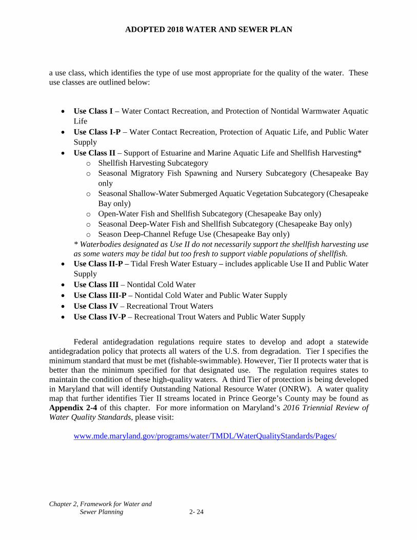
a use class, which identifies the type of use most appropriate for the quality of the water. These use classes are outlined below:
• Use Class I – Water Contact Recreation, and Protection of Nontidal Warmwater Aquatic Life
• Use Class I-P – Water Contact Recreation, Protection of Aquatic Life, and Public Water Supply
• Use Class II – Support of Estuarine and Marine Aquatic Life and Shellfish Harvesting* o Shellfish Harvesting Subcategory o Seasonal Migratory Fish Spawning and Nursery Subcategory (Chesapeake Bay
only o Seasonal Shallow-Water Submerged Aquatic Vegetation Subcategory (Chesapeake
Bay only) o Open-Water Fish and Shellfish Subcategory (Chesapeake Bay only) o Seasonal Deep-Water Fish and Shellfish Subcategory (Chesapeake Bay only) o Season Deep-Channel Refuge Use (Chesapeake Bay only)
* Waterbodies designated as Use II do not necessarily support the shellfish harvesting use as some waters may be tidal but too fresh to support viable populations of shellfish.
• Use Class II-P – Tidal Fresh Water Estuary – includes applicable Use II and Public Water Supply
• Use Class III – Nontidal Cold Water • Use Class III-P – Nontidal Cold Water and Public Water Supply • Use Class IV – Recreational Trout Waters • Use Class IV-P – Recreational Trout Waters and Public Water Supply
Federal antidegradation regulations require states to develop and adopt a statewide
antidegradation policy that protects all waters of the U.S. from degradation. Tier I specifies the minimum standard that must be met (fishable-swimmable). However, Tier II protects water that is better than the minimum specified for that designated use. The regulation requires states to maintain the condition of these high-quality waters. A third Tier of protection is being developed in Maryland that will identify Outstanding National Resource Water (ONRW). A water quality map that further identifies Tier II streams located in Prince George’s County may be found as Appendix 2-4 of this chapter. For more information on Maryland’s 2016 Triennial Review of Water Quality Standards, please visit:
www.mde.maryland.gov/programs/water/TMDL/WaterQualityStandards/Pages/

ADOPTED 2018 WATER AND SEWER PLAN
Chapter 2, Framework for Water and Sewer Planning 2- 25
2.3 COMMUNITY PLANNING FRAMEWORK The rapid urbanization of Prince George's County has created an increasing awareness of the need for protecting environmental quality while providing the necessary infrastructure for the community. Until the late 1980s, it was the County's policy that all areas developed at densities less than one dwelling unit per acre were to be served by individual wells and septic systems, and that public systems should not be extended into such areas. This policy was based on the assumption that lots would be uniformly large, the cost of extending service prohibitively high, and such extensions might encourage inappropriate requests for increased density. In 2006 new legislation was passed that established regulations for the “conservation subdivision” techniques which allows a reduction in the minimum lot size required in the zone. The reduced lot size allowed for an increase in the preservation of valuable environmental, historic and cultural resources, and unique site characteristics. The conservation subdivision regulations are the required method of residential development in Sustainable Growth Tier IV (Environmental Strategy Area 3, or ESA 3, formerly the Rural Tier), for minor preliminary plans of subdivision and major preliminary plans of subdivision in Sustainable Growth Tier III, and are optional in specific zones in Environmental Strategy Areas 1 and 2, or ESA 1 and 2 (formerly the Developing and Developed tiers, respectively). In ESA 1 and 2 the conservation subdivision option results in a reduction in the costs for sewer extensions because of the reduced lot sizes. Land in ESA 3 is typically outside the public water and sewer service boundaries. 2.3.1 Role of the General Plan in Water and Sewer Planning The Prince George's County Council approved Plan Prince George’s 2035 Approved General Plan as the General Plan on May 6, 2014. As a comprehensive 20-year general plan, the General Plan is a blueprint for long-term growth and development in Prince George’s County. The General Plan contains six principles that guide the plan’s vision, policies, and strategies:
1. Concentrate future growth 2. Prioritize and focus our resource 3. Build on our strengths and assets 4. Create choice communities 5. Connect our neighborhoods and significant places 6. Protect and value our natural resources
The General Plan addresses the provision of public facilities which includes water and sewer needed to serve existing and future county residents and businesses. The effectiveness, sustainability, design, and location of these facilities are essential components to the County’s quality of life, economic competitiveness, and environmental health. It recognizes the mounting cost of providing and maintaining water and sewer service will increasingly burden the County’s budget. This underscores the importance of curbing the County’s sprawling development pattern.
The majority of recent development in the County occurred in suburban locations outside the Capital Beltway and outside of designated growth centers, resulting in a sprawling development pattern (see Plan 2035, p.78). Residential development has continued to encroach

ADOPTED 2018 WATER AND SEWER PLAN
Chapter 2, Framework for Water and Sewer Planning 2- 26
on our rural and agricultural areas, endangering our farmland and natural resources, resulting in costly water, sewer, and road expansions, and triggering the construction of large stormwater management facilities (see Plan 2035, p.93).
Natural resources are increasingly being degraded and county financial resources are
stretched across numerous priorities, such as our schools and police, community services, and economic development initiatives. It is critical that new development not disproportionately use our county’s limited resources and harm our natural environment. One way to do this is to proactively encourage development to build on our existing infrastructure – our transit, roads, trails, water and sewer system, and public facilities – rather than to build new infrastructure. This will help ensure that we use our tax dollars efficiently and protect our rural and agricultural communities and open spaces.
Prince George’s County is at a crossroads. The easy road continues our sprawling
development pattern, strains our county’s budget, degrades our natural environment, complicates health issues, and fuels congestion. The bold road, proposed by the General Plan, leads to a strong economy built upon concentrated public investment in targeted transit-oriented commercial and mixed-use centers. The strategic approach attracts new private investment, businesses, and residents to the county and generates the revenue the county needs to provide well-maintained, safe, and healthy communities, improved environmental resources, high-quality public schools, and other critical services (see Plan 2035, p.7). Map 2-8, the General Plan Growth Policy Map, conveys this strategic approach.
The Growth Policy Map visually communicates where and how we should grow and evolve
as a county over the next 20 years, as well as which parts of the county will not experience substantial change (see Plan 2035, p.17). It introduces six new area classifications:
1. Regional Transit Districts 2. Employment Areas 3. Local Centers 4. Established Communities 5. Future Water and Sewer Service Areas 6. Rural and Agricultural Areas
These six new area classifications replace the 2002 General Plan tier, center, and corridor
designations. The Growth Policy Map takes into account our existing development patterns, environmental features, existing and planned transportation investments, and projected growth and balances these factors with the county’s underlying capacity to meet the needs of existing communities and to accommodate future development (see Plan 2035, p.17).
The General Plan designates eight centers – Branch Avenue Metro, College Park/UM
Metro, Greenbelt Metro, Largo Town Center Metro, National Harbor, New Carrollton Metro, Prince George’s Plaza Metro, and Suitland Metro – with extensive transit and transportation infrastructure and the long-term capacity to become mixed-use, economic generators for the county as Regional Transit Districts (see Plan 2035, pp.18-20)


ADOPTED 2018 WATER AND SEWER PLAN
Chapter 2, Framework for Water and Sewer Planning 2- 28
Regional Transit Districts are high-density, vibrant, and transit-rich mixed-use areas envisioned to capture the majority of future residential and employment growth and development in the County.
Employment Areas are areas commanding the highest concentrations of economic activity
in four targeted industry clusters – healthcare and life sciences; business services; information, communication, and electronics; and the Federal Government.
Local Centers are focal points of concentrated residential development and limited
commercial activity serving our Established Communities. The General Plan contains recommendations for directing medium- to medium-high residential development, along with limited commercial uses, to these locations rather than scattering them throughout the Established Communities.
Established Communities make up the county’s heart – its established neighborhoods,
municipalities, and unincorporated areas outside designated centers. These are existing residential neighborhoods and commercial areas served by public water and sewer outside of the Regional Transit Districts and Local-Centers. Established communities are most appropriate for context-sensitive infill and low- to medium-density development.
Future Water and Sewer Service Areas are holding areas that are located inside the Growth
Boundary, but have not been approved for a water and sewer category change. Development here is largely determined by the availability and capacity of water and sewer service. Controlling the expansion of water and sewer service is the easiest and most effective way a jurisdiction can manage and phase growth.
Rural and Agricultural Areas are areas with significant natural and agricultural resources
that are best suited for low-density residential development on well and septic, agricultural activity, and forest preservation. The General Plan proposes this area remain low-density residential or support park and open space land uses and focuses new investment on maintaining existing infrastructure and stabilizing small-scale neighborhood-oriented commercial activities that support the areas’ rural lifestyle and character (see Plan 2035, p.106).
The growth boundary is important because it designates the areas that are eligible to receive
public water and sewer service and impacts where we grow and develop. The rural and agricultural areas are not eligible for public water and sewer service (see Plan 2035, p.18). This has made them useful in assessing the capacity and potential of each center to support future growth and development. The General Plan offers a range of policy choices for controlling sprawl and ensuring cost-effective use of public resources to maintain a high and sustainable quality of life. Implementation of the General Plan’s policies and strategies will involve making choices concerning future development patterns, while taking into consideration the cost of providing needed infrastructure and protecting the environment. Successful implementation should occur through a combination of regulations, programs and plans, including the Water and Sewer Plan.

ADOPTED 2018 WATER AND SEWER PLAN
Chapter 2, Framework for Water and Sewer Planning 2- 29
2.3.2 Projected Growth Rate, Land Use and Zoning The County’s future growth pattern directly influences the cost, sizing, and siting of water and sewer facilities. Population, employment, households, and dwelling units are the four major parameters affecting the demand for water and sewer facilities, the amount of biosolids generation, and the amount of land needed for collection, transmission, storage, treatment, and disposal facilities. Map 2-9 is reflective of the land use in Prince George’s County. Table 2-1. Approximate Population Forecasts by WSSC Sewer Basins for Prince George’s County
Sewer Basin 2010 2015 2020 2025 2030 2035 2040 2045 Beaverdam 67,586 67,761 69,505 70,129 70,539 72,525 74,376 76,369 Broad Creek 94,541 95,671 96,673 98,610 99,377 100,001 101,091 102,543 Horsepen 15,880 17,032 17,045 17,230 17,389 17,389 17,390 17,392 Lower Anacostia 25,333 26,724 26,807 26,823 26,923 27,228 27,303 27,499
Mattawoman 8,678 9,856 17,554 18,680 18,964 18,979 18,980 18,980 Northeast Branch 119,789 122,270 123,328 126,120 131,597 133,758 135,673 137,941
Northwest Branch 63,808 64,732 64,735 64,789 65,433 66,501 66,982 67,038
Oxon Run 75,891 76,651 77,173 77,474 77,925 79,039 80,567 81,507 Paint Branch 38,841 39,789 39,837 39,874 40,073 40,075 40,130 40,137 Parkway 52,821 54,521 54,523 54,525 54,747 54,746 54,754 54,993 Patuxent Central 35,119 36,123 38,236 39,216 39,296 40,243 40,665 40,702
Patuxent North 195 205 205 205 205 205 205 205
Patuxent South 5,187 5,710 5,711 5,731 5,769 5,843 5,922 5,977
Piscataway Creek 70,934 74,411 74,439 76,764 78,559 79,559 82,525 83,839
Potomac River South 3,903 4,035 4,078 4,291 4,314 4,314 4,314 4,314
Sligo Creek 19.395 19,678 19,679 19,680 19,684 19,719 19,685 19,814 Western Branch 184,512 188,367 192,724 196,988 201,266 206,826 210,929 215,733
Zekiah 383 894 894 894 894 894 894 894 Grand Total 863,420 904,430 923,144 938,023 952,955 967,842 982,385 995,876
Source: Prince George’s County Planning Department (M-NCPPC) Round 9.0 Cooperative Forecast


ADOPTED 2018 WATER AND SEWER PLAN
Chapter 2, Framework for Water and Sewer Planning 2- 31
Table 2-2. Land Use and Zoning, Prince George’s County
Existing Land Use (already developed)
Zoned
Land Use Category Acres % of Total Acres % of Total
Residential 80,320 28.3% 237,074 84.7% Commercial/Industrial 13,488 4.8% 20,316 7.3% Institutional/Open Space 49,796 17.6% - - Mixed Use 286 0.1% 7,491 2.7% Forest 79,619 28.1% - - Agriculture 27,188 9.6% - - Extractive/Barren/Bare 22,675 8.0% - - Wetland 7,015 2.5% - - R-O-W/Unclassified 14,929 5.3% Total 283,479 279,810 100%
Source: Prince George’s County Planning Department (M-NCPPC), April 2011. These forecasts of growth for Prince George’s County are contained in the Round 9.0 Cooperative Forecasts, prepared by the Prince George’s County Planning Department, Maryland-National Capital Park and Planning Commission (M-NCPPC), in conjunction with the Metropolitan Washington Council of Governments (MWCOG). These forecasts cover the time period from 2010 to 2045 and are shown in Table 2-3. TABLE 2-3. Prince George’s County Forecasts: 2010-2040
2010 2015 2020 2025 2030 2035 2040 2045 Population 863,420 904,430 923,144 938,023 952,955 967,842 982,385 995,876 Dwelling Units
328,182 344,818 350,947 357,706 367,453 375,582 382,675 389,907
Households 304,042 321,143 334,268 343,865 355,494 363,283 370,023 376,787 Employment 333,942 338,565 349,048 366,326 375,741 385,510 393,336 402,147
Source: M-NCPPC, Countywide Planning Division, Research Section, Cooperative Forecast, Round 9.0, 2016.

ADOPTED 2018 WATER AND SEWER PLAN
Chapter 2, Framework for Water and Sewer Planning 2- 32
Growth and its distribution generate physical, economic and environmental pressures on the County’s water and wastewater systems. The population increase between 2015 and 2025 is expected to be 33,593. Table 2-4 presents the projected growth for the period from 2015 – 2045. By the year 2045, The County’s population is estimated to reach 995,876. The population over three decades will have grown by 91,446 or 10.1 percent. TABLE 2-4. Projected County Growth Patterns, 2015-2045
Type of Growth 2015-2025 % Change 2025-2035 % Change 2035-2045 % Change Population 33,593 3.71% 29,819 3.18% 28,034 2.90% Dwelling Units 12,888 3.74% 17,876 5.00% 14,325 3.81% Households 22,722 7.08% 19,418 5.65% 13,504 3.72% Employment 27,761 8.20% 19,184 5.24% 16,637 4.32%
Source: M-NCPPC, Countywide Planning Division, Research Section, Cooperative Forecast, Round 9.0, 2016 Since 2000, the central and southern portions of the County outside the Beltway experienced increased population growth. This growth is expected to continue to 2045 with an increasing share of growth going to the southern portion of the County. After 2015, areas inside the Capital Beltway are expected to receive increased population growth with the promotion of infill development and redevelopment around Metro stations. Infill development is the term used to describe development of land located in areas that are already developed, and that have the infrastructure in place. Forecasted redevelopment around Metro stations is based on the General Plan goal of more intense development at transit stations. During the same time period, more growth is also expected in the northern part of the County. Factors, such as transportation and job opportunities, will play an important role in defining this growth within the County. Map 2-10 depicts the 2010 population density for Prince George’s County. During the period from 2015 to 2025, total employment in the County is projected to increase by 27,761 jobs. From 2015 to 2045, total employment is expected to increase by 63,582 or 18.8%. The northern half of the County will remain the dominant employment center but new concentrations of growth will occur in the central and southern sections. An increase of 22,722 households is expected between 2015 and 2025 with an additional 19,418 between 2025 and 2035. The increase in households between 2035 and 2045 is expected to be an even smaller 13,504. Household growth is expected in the southern part of the county, as well as in master-planned developments such as Westphalia and Konterra. Infill development and redevelopment will characterize new dwelling unit growth inside the Capital Beltway after 2010. In the southern portion of the County, new growth will continue along MD 5 and U.S 301 and in the north along U.S 1. These trends will generally continue from 2015 to 2025. A projected 12,888 new dwelling units are expected to be built from 2015 to 2025 with an additional 32,201 more units between 2025 and 2045. Public Land Map 2-11 is provided to show the areas in which Federal, State, County and Municipal facilities makeup the County, having provided for a 12.7% increase in employment growth. Appendix 2-3 provides the names for these public facilities.


ADOPTED 2018 WATER AND SEWER PLAN
Chapter 2, Framework for Water and Sewer Planning 2- 35
2.4 LEGAL FRAMEWORK The County’s Water and Sewer Plan is governed by State law and is directly and indirectly guided by Federal and State law. Since the early 1970s, there have been numerous legislative actions that directly correlate to water resources and sewer planning. No longer is water and sewer planning merely a process of extending water and sewer lines to owners’ properties. Now the County is required to consider a number of issues prior to approving water and sewer service. These include: • Adequacy of water resources • Water quality standards • Effluent standards • Methods of sewage treatment and disposal • Water supply • Cost effectiveness • Fulfillment of County plans and goals 2.4.1 Federal Law A. Federal Water Pollution Control Act Amendments of 1972. These represented a complete
rewrite of all existing water pollution control laws. As stated in the declaration of goals and policy statement, “The objective of this Act is to restore and maintain the chemical, physical, and biological integrity of the nation’s waters. In order to achieve this objective, it is hereby declared that, consistent with the provisions of this Act:
1. It is the national goal that discharge of pollutants into the navigable waters be eliminated; 2. It is the national goal that, wherever attainable, an interim goal of water quality, which
provides for the protection and propagation of fish, shellfish, and wildlife and provides for recreation in and on the water, be achieved;
3. It is the national policy that discharge of toxic pollutants in toxic amounts be prohibited; and 4. It is the national policy that a major research and demonstration effort be made to develop
technology necessary to eliminate the discharge of pollutants into the navigable waters, waters of the contiguous zone, and the oceans.”
B. Clean Water Act of 1977. This legislation introduced the concept of effluent limitations,
which is the elimination of pollution before wastewater is discharged into a waterway. Under the Clean Water Act, water pollution control is based on the concept of stream standards and the capacity of a waterway to assimilate pollutants that are discharged.

ADOPTED 2018 WATER AND SEWER PLAN
Chapter 2, Framework for Water and Sewer Planning 2- 36
Essential to the Clean Water Act is the National Pollutant Discharge Elimination System (NPDES), which requires permits from either the U.S. Environmental Protection Agency (EPA) or the State for every point source discharge such as power plants, certain industrial processing plants, and sewage treatment plants. Each permit is for five years and must contain a schedule of compliance. The Maryland Department of the Environment (MDE) is responsible for implementing the NPDES program for the State of Maryland. Prince George’s County has obtained a nonpoint source NPDES permit from the MDE to cover stormwater runoff and stormwater discharges. C. Safe Drinking Water Act. On December 16, 1974, Congress enacted the Safe Drinking Water
Act that provides national standards for public water supply systems and sources of drinking water for any community water supply that serves 15 service connections or 25 individuals. Federal standards for drinking water have been in effect since 1914, when the Federal Government enacted measures to prevent the interstate spread of communicable diseases. The Act authorizes the EPA to do the following:
1. Conduct research on technological and health aspects of providing public drinking water; 2. Assist the states to improve their drinking water programs by providing technical assistance,
employee training and financial support; 3. Assure adequate material supply for treatment for public systems; and 4. Establish a regulatory program to protect underground sources of water. Implementation and enforcement of this Act is the responsibility of MDE. The 1996 amendment to the Safe Drinking Water Act called for source water assessments (SWA) to protect water supply sources. The Washington Suburban Sanitary Commission’s on-going work on the Patuxent reservoirs and the source water assessments being conducted on the Potomac River are on behalf of MDE. These SWA projects are further discussed in Sections 3.2.1 and 3.2.2 of this Plan.
2.4.2 State Law Maryland State laws guide components within the Prince George’s County Water and Sewer Plan. The components herein described are subject to the State Environment Article, Title 9, Subtitle 5; the Annotated Code of Maryland Regulation (COMAR), Title 26, Subtitle 03; and Senate Bill 1107 (1975). These specific laws are appendices to this Plan. A. Prince George’s County Comprehensive Water and Sewer Plan: State law requires all
counties within the State to prepare and submit a comprehensive water and sewer plan. Prince George’s and Montgomery counties are required to submit their plans triennially. The

ADOPTED 2018 WATER AND SEWER PLAN
Chapter 2, Framework for Water and Sewer Planning 2- 37
purpose of the plan is to coordinate and control the extension of community water and sewer systems in a manner consistent with local development policies and objectives. The Water and Sewer Plan is subject to review and approval by the MDE.
B. Washington Suburban Sanitary Commission (WSSC): Chapter 392, Laws of Maryland, 1975,
requires actions of the WSSC to conform to adopted and approved plans, programs and policies of the elected governing body of Prince George’s County. The Commission may not grant water or sewer service connections, hook-ups, or authorization for service, or otherwise extend water and sewer service to any new development within the Prince George’s County portion of the Sanitary District unless the development is in conformance with adopted and approved plans, programs and policies of the County governing body or other rules and regulations that the governing body may desire to include in their duly adopted and approved comprehensive Water and Sewer plans, amendments, or revisions.
C. WSSC Six-Year Capital Improvement Program (CIP) and Capital and Operating Budget:
The Maryland Annotated Code requirements governing the Six-Year CIP and the Capital and Operating Budget of the WSSC provide a limited degree of County control over WSSC construction programs. With both the six-year program and the annual budget, WSSC must submit a proposed list of projects planned for the County, including treatment and storage facilities, major water and sewer lines, pumping stations and force mains, and other major facilities.
The County Executive reviews the WSSC CIP proposal and, along with his or her comments and recommendations, submits them to the County Council by March 15 of each year. After public hearings, the County Council approves the WSSC Six-Year CIP and annual operating budgets with modifications as desired. In addition to approving the construction schedule for major water and sewer facilities, the County Council may impose restrictions on the area to be served by individual sewer and water projects. Following County Council action, the WSSC must adopt the CIP as approved by the County Council. Although WSSC is prohibited from undertaking any project that is not scheduled in the first year of this program, WSSC is not obliged to implement any project that the Commission determines to be financially infeasible. Also, when WSSC proposes a project lying totally or partially within Montgomery or Prince George’s counties that is designed to provide services in whole or in substantial part to the other County, the project may be disapproved with the concurrence of the governing body that is to receive the designed services. In addition, the County in which the project is physically proposed has the authority to direct modifications in project location and scheduling provided that such modification or change does not prevent the services from being available when needed. This authority to modify locations may be exercised to affect reasonable changes during the County Council’s action in reviewing the WSSC CIP during the year in which the project is first introduced. Thereafter, the authority to make further modifications is limited to those that would not result in substantial net additional costs to the WSSC, unless the County directing the modifications reimburses the WSSC for any additional net cost increases that may be required.

ADOPTED 2018 WATER AND SEWER PLAN
Chapter 2, Framework for Water and Sewer Planning 2- 38
D. State Water Pollution Control Regulations: MDE has the responsibility for water quality regulations and standards. The standards shall protect public health, safety and welfare, and the present and future use of the waters for public water supply, the propagation of fish and other aquatic life and wildlife, recreational purposes, and agricultural, industrial, and other legitimate uses. All standards may be amended from time to time by MDE and shall include, but not be limited, to:
1. Water quality standards specifying, among other things, the maximum short-term and
long-term concentrations of pollutants in the water, minimum permissible concentrations of dissolved oxygen and other desirable matter in the water and the temperature range for the water;
2. Effluent standards specifying the maximum loading or concentrations and the physical,
thermal, chemical, biological and radioactive properties of wastes that may be discharged into the waters; standards must be at least as stringent as those specified by the NPDES;
3. Rules and regulations defining techniques for filling and sealing of abandoned water
wells and holes, for disposal wells and for landfills to prevent groundwater contamination, seepage, and drainage into the waters of the State;
4. Rules and regulations regarding the sale, offer, use or storage of articles that constitute
a water pollution hazard as determined by MDE;
5. Rules and regulations outlining the procedures for water pollution episodes or emergencies that constitute an acute danger to health or the environment;
6. Rules and regulations prescribing method, facilities, standards, and devices for transfer,
storage, separation, removal, treatment, and disposal of oil and other unctuous substances; and
7. Rules and regulations specifying standards for equipment and procedures for
monitoring pollutants, collection of samples, log-keeping and reporting. E. The Chesapeake Bay Critical Area Law: The Chesapeake Bay Critical Area Protection
Program was enacted by the State legislature in 1984 because of concern about the decline of natural resources in the Chesapeake Bay. It is acknowledged that this decline is related to the intensity of human activities within the Bay watershed. The intent of the Critical Area legislation is to address the impact of human activities on the Bay by designating a 1,000-foot wide geographical area around the waters of the Chesapeake Bay and its tidal tributaries as the “Chesapeake Bay Critical Area.” Within the designated “Critical Area,” it is County policy to mitigate the negative impact of development on the water quality and habitat of the Bay. Land within the Critical Area is subdivided into three zones: Intensely Developed

ADOPTED 2018 WATER AND SEWER PLAN
Chapter 2, Framework for Water and Sewer Planning 2- 39
Overlay (IDO), Limited Development Overlay (LDO), and Resource Conservation Overlay (RCO). The purpose of the Critical Area legislation is to generally encourage the siting of intensive development away from the Critical Area, but at the same time allow a limited amount of such development where appropriate.
The County’s Water and Sewer Plan may be utilized to implement the three Critical Area designations and to direct the extension of water and sewer service accordingly. For example, in the Resource Conservation Overlay, the permitted residential density is one dwelling unit per 20 acres. Such areas may be redesignated to water and sewer Category 6 (no planned service) if the properties are not already in that category. The Water and Sewer Plan is reviewed regularly to ensure consistency with the policies and ordinances of the Prince George’s County Chesapeake Bay Critical Area Program.
F. Wetlands Regulations: Impacts to tidal wetlands or within tidal waters are regulated by the
U.S. Army Corps of Engineers under the River and Harbors Act of 1899 (33 USC 403) and by the Maryland Department of the Environment (Title XVI of the Environment Article). Locally, impacts to tidal wetlands and tidal waters are regulated by the Prince George’s County Chesapeake Bay Critical Area Program. Prior to the issuance of any permit by DPIE, appropriate permits, licenses, or letters of permission must be obtained by the applicant from the Federal and State permit agencies. Non-government projects must have a Chesapeake Bay Critical Area Plan approved by the Prince George’s County Planning Board. The Chesapeake Bay Critical Area Commission in Annapolis must approve government projects.
Impacts to nontidal wetlands or the 25-foot wetland buffer must be approved by MDE via a Joint Federal/State Wetland Permit or Letter of Permission pursuant to Maryland General Permit MGPD-1 issued by the U.S. Army Corps of Engineers, or have an approved U.S. Army Corps of Engineers Permit or Letter of Permission pursuant to Section 404 of the Clean Water Act (33 USC 1344). Maryland law governing nontidal wetlands is contained in Title V of the Environment Article.
Impacts to nontidal wetlands are locally reviewed and regulated by the Subdivision Ordinance (Section 24-130), and review and approval of Tree Conservation Plans are required through the Prince George’s County Woodland Conservation Ordinance.
In general, impacts to tidal or nontidal wetlands should be avoided unless necessary. Necessary impacts must be minimized and, where appropriate, mitigation will be required.
G. Smart Growth Legislation: In 1997, the State of Maryland initiated the Smart Growth and
Neighborhood Conservation Program. Through a variety of legislative efforts, the General Assembly has approved the following:
• Smart Growth Areas Act: A law limiting most State infrastructure funding to existing
communities or those designated for growth. • Rural Legacy: A grant program to purchase development rights and to preserve large rural
areas from sprawl.

ADOPTED 2018 WATER AND SEWER PLAN
Chapter 2, Framework for Water and Sewer Planning 2- 40
• Brownfields programs: Several programs to facilitate cleanup of contaminated industrial areas and redevelopment of those sites.
• Job Creation Tax Credit: Income tax credits for businesses creating new jobs within designated areas.
• Live-Near-Your-Work Program: Matching grants to homebuyers who purchase homes near their workplace.
The designation of the Smart Growth Priority Funding Areas is required to evaluate the availability of existing or planned water and sewer service and the development density. MDE has redirected most of its capital programs to facilitate development and redevelopment in accordance with the Smart Growth legislation.

ADOPTED 2018 WATER AND SEWER PLAN
Chapter 2, Framework for Water and Sewer Planning 2- 41
APPENDIX 2-1
Category Exceptions to the Sewer Envelope
I. Category 6 Designations inside the Sewer Envelope
1. Greenbelt Park 2. U.S. Department of Agriculture, College Park 3. U.S. Department of the Interior, Greenbelt 4. Fort Lincoln Cemetery, Port Towns 5. Belt Woods, Bowie/Mitchellville 6. Nash Woods, Bowie 7. National Harmony Cemetery, Landover 8. Lincoln Memorial Cemetery, Suitland 9. Oxon Hill Farm 10. Rosaryville State Park, Upper Marlboro 11. Louise M. Cosca Park, Clinton 12. Duval Woods, Upper Marlboro. Water and Sewer Category 6. Approved by
CR-15-2004. Tax Map 128 C-1/2 & D-1. Parcels 48, 49 & 54. 13. Magruder Tract West, Upper Marlboro. Sewer Category 6. Approved by CR-64-2006.
Tax Map 118 E-2. Part of Parcel 10. 14. Woodyard Estates, Upper Marlboro. Sewer Category 6. Approved by CR-17-2009. Tax
Map 109 B-3. Lots 7 – 12 & 43 – 49 II. Category 3 Designations outside the Sewer Envelope
(Descriptions of the referenced properties reflect proposals at the time of approval) Group A – Properties are currently served or will be served by public water and/or sewer facilities
1. Federally owned property: U.S. Department of the Interior – Patuxent Research Refuge, Laurel. Selected
areas. Water and Sewer Category 3. U.S. Department of Agriculture – Beltsville Agricultural Research Center,
Beltsville. Selected areas. Water and Sewer Category 3. U.S. Air Force Communications Site, Brandywine. Tax Map 155 E-3. Parcel
5. Approved for Water and Sewer Category 3 – currently using well and septic facilities.
U.S. Department of Agriculture – College Park. Tax Map 19 A-4, Parcel 155; Developed; Amend to Water and Sewer Category 3. Tax Map 26 A-1, Parcel 6. Undeveloped. Water and Sewer Category 6.

ADOPTED 2018 WATER AND SEWER PLAN
Chapter 2, Framework for Water and Sewer Planning 2- 42
Group A (continued) – Properties are currently served or will be served by public water and/or sewer facilities
2. Normal School Road area, Bowie: Tax Map 29 D-1/2. Parcels 12, 16, 32, 34, 35, 44, 45, 46, 47, 133, 134, 135, 136, 175, 191, 230, 243, 254, 276, 279, 308, 321, 322, and Lot 1. Water Category 3.
3. State of Maryland property, Upper Marlboro. Tax Map 111 A-1. Parcel 48. Water and
Sewer Category 3.
4. Old Indian Head Road area, Cheltenham: Maryland Department of Natural Resources – Tax Map 126 D-4. Parcel 65. Tax Map 127 B-4. Parcel 111. Water Category 3.
5. Broadcreek area, Fort Washington. Tax Map 122, F-3, P. 83. Developed. Water and Sewer Category 3. Harmony Hall Elementary School. 122, F-3, Parcel A. Developed. Amend to Sewer 3.
6. Ridges I & II, Piscataway. Tax Map 143 E-2. Water and Sewer Category 3.
7. Brandywine VFD, Brandywine. Tax Map 145 E-3. Parcels 76, 106 and 107. Water and
Sewer Category 3.
8. Accolawn Road area of Accokeek: • Tax Map 151 A-4. Lots 1-4, Jamestowne Estates and Lots 29-36, Accolawn Estates.
Water and Sewer Category 3. • Tax Map 151 A-4. Lots 7, 8, 11, 14-20, 25, 27, 28, and Parcel 94, Accokeek Lawn
Subdivision. Water Category 3.
9. Hickory Hills Road, Accokeek. Tax Map 160 D-2, Lots 1 and 2. Water Category 3.
10. Cherry Hill Park, College Park. Tax Map 18 C-3/4. Parcels 103, 105, 106 and 186. Water and Sewer Category 4 approved by CR-64-2006; Water and Sewer Category 3, approved July 2011. Rural Tier, outside the Sewer Envelope.
11. Former WSSC Property, West Laurel Recreational Center (M-NCPPC). Tax Map 2, D/E-
2, P/O Parcel 26. Developed. Amend to Water and Sewer Category 3. Group B – Properties served by or approved for shared facilities or smaller community systems.
1. Forest Hills, Bowie. Tax Map 47 D-1. Lots 3-21. The property is served by the City of Bowie water system. Water Category 3. Tax Map 47 D-1. Lot 4. Delaney Property. (Formerly Sewer Category 3) Shared Septic.
2. Bragg Motel, Upper Marlboro. Tax Map 110 C-2. Parcel 10. (Formerly Water and
Sewer Category 3) Private Community System.

ADOPTED 2018 WATER AND SEWER PLAN
Chapter 2, Framework for Water and Sewer Planning 2- 43
Group B (continued) – Properties served by or approved for shared facilities or smaller community systems.
3. Croom Vocational School, Croom. Tax Map 120 A-1. Parcel A. (Formerly Sewer Category 3) Community System.
4. Brandywine Estates, Brandywine. (Formerly Sewer Category 3) Shared Septic Facility.
Tax Map 165 B-2, C-2, Parcel 1 and Parcel 42.
5. Cedarville Mobile Home Park, Cedarville. (Formerly Sewer Category 3) Private Community Septic System. Tax Map 166 A-2. Parcel 91.
6. Danville Estates, Piscataway. Tax Map 143 D-4. Part of Lot 23. Shared Septic Facility.
III. Compliance in accordance to the Water and Sewer Plan
1. Albani Knolls and Marion Acres subdivisions; Category 3; CR-20-2013 2. Vistas at Laurel Lakes; Category 3; CR-16-2015 3. Greencastle Manor; Sewer 3; CR-16-2015 4. Glendale Subdivision; Category 3; CR-16-2015 5. Old Chapel Estates; Category 3; CR-16-2015 6. Cleary Lane & Romsey Drive; Category 3; CR-16-2015 7. Holmehurst Subdivision; Sewer 3; CR-16-2015 8. Cabin Branch/Pyles subdivisions; Category 3; CR-16-2015 9. Kings Council Condo/Villages of Marlborough; Category 3; CR-16-2015 10. Sunrise subdivision; Category 3; CR-16-2015 11. Temple Hills Acres; Sewer 3; CR-16-2015 12. Ridgevale subdivision; Sewer 3; CR-16-2015 13. Williamsburg Estates; Category 3; CR-16-2015 14. Marlton Town Center; Category 3; CR-16-2015 15. Clinton Grove/Hyde Field Estates; Sewer 3; CR-16-2015 16. Boniwood area; Category 3; CR-16-2015 17. Brandywine Heights/Early Haven area; Category 3; CR-16-2015 18. Shafer Lane; Sewer 3; CR-43-2016 19. Crescent Drive area; Sewer 3; CR-43-2106 20. Allentown Road & Webster Place; Sewer 3; CR-43-2016 21. Lanham Lane; Sewer 3; CR-43-2016 22. River Bend area; Category 3; CR-43-2016 23. Allentown Road area; Sewer 3; CR-43-2016 24. Riverview Road/Gates Drive area; Category 3; CR-43-2016 25. Old Fort Road; Sewer 3; CR-43-2016 26. Gallahan Road; Sewer 3; CR-43-2016 27. Allen Gayles Acres; Category 3; CR-43-2016 28. West Manning Road parcels; Category 3; CR-43-2016 29. Livingston Grove; Sewer 3; CR-43-2016 30. Marchegiani/Bellevue/Bealle Hill area; Sewer 3; CR-43-2016

ADOPTED 2018 WATER AND SEWER PLAN
Chapter 2, Framework for Water and Sewer Planning 2- 44
III. Compliance in accordance to the Water and Sewer Plan (continued)
31. Simmons Acres; Category 3; CR-43-2016 32. Spring Grove; Category 3; CR-43-2016 33. Brock Hills subdivision; Sewer 3; CR-23-2017 34. Poplar/Oak Road area; Sewer 3; CR-23-2017 35. Old Allentown Road area; Category 3; CR-23-2017 36. Riverside Baptist Church/9111 Oxon Hill Road; Category 3; CR-23-2017 37. Littleworth subdivision; Category 3; CR-23-2017

ADOPTED 2018 WATER AND SEWER PLAN
Chapter 2, Framework for Water and Sewer Planning 2- 45
APPENDIX 2-2
General Plan Compliance Subregion Master Plan Changes
Water and Sewer Category Designations 5, 4, & 3 and Sewer Envelope Realignment

ADOPTED 2018 WATER AND SEWER PLAN
Chapter 2, Framework for Water and Sewer Planning 2- 46
This page intentionally left blank

ADOPTED 2018 WATER AND SEWER PLAN
Chapter 2, Framework for Water and Sewer Planning 2- 47
I. Compliance in accordance to the General Plan (and amendments)
During the drafting of this Plan, the following properties previously designated according to the 2002 General Plan, were redesignated within the Growth Boundary or within the Rural Agricultural area in accordance to the policies of the adopted General Plan. Consequently, the water and sewer categories are reversed or amended to reflect the appropriate servicing of the redesignation.
1. WSSC Property, Laurel. Tax Map 2 E-2. Parcel 26. Formerly Water and Sewer
Category 5. Developed. Rural and Agricultural areas; outside the Sewer Envelope. Exception to the Sewer Envelope. Amend to Water and Sewer Category 3.
2. Patuxent Greens Golf Course area, Laurel. Tax Maps 6, F-3, E/F-4 & 10, E/F-1/2/3/4.
Water and Sewer Category 6; within the Growth Boundary; inside the Sewer Envelope; Amend to Water and Sewer Category 5. Further advanced to Category 4, CR-6-2018, and ultimately Category 3, CR-44-2019.
3. U.S.DA south area, Beltsville. Tax Maps 25, B/C-1/2 & D-3/4. Water and Sewer
Category 6; within the Growth Boundary; inside the Sewer Envelope; Amend to Water and Sewer Category 5.
4. City of Greenbelt, Crescent Road. Tax Maps 27, A/B-2/3. Water and Sewer Category 6;
within the Growth Boundary; inside the Sewer Envelope; Amend to Water and Sewer Category 5.
5. Race Track Road/Bowie State University area, Bowie. Tax Maps 22, D/E-3/4. Water and
Sewer Category 6; within the Growth Boundary; inside the Sewer Envelope; Amend to Water and Sewer Category 5.
6. City of Bowie, Public Works Road. Tax Maps 38, C/D-1. Water and Sewer Category 3 &
5; Rural and Agricultural areas; outside the Sewer Envelope; Reversed to Water and Sewer Category 6.
7. Prince George’s Stadium and surrounding areas: Jesuits Property/Sacred Hearts Church
area, Bowie. Tax Map 38 D/E-3. Parcels 55, 60 & p/o Lot 1-A. Growth Boundary; inside the Sewer Envelope. Water and Sewer Category 5. Zehner property, Bowie. Tax Map 48 A-4. Parcel 4. Water and Sewer Category 5 & 6. Not Developed. Rural and Agricultural areas; outside the Sewer Envelope. Reversed to Water and Sewer Category 6.
8. Broadcreek Area(s), Fort Washington. Tax Maps 113, E/F-4; 114, A-4; 122, E/F-1/2/3;
123, A-1/2/3. Water and Sewer Categories 5& 6. Developed/Not Developed. Rural and Agricultural areas; outside the Sewer Envelope. Reversed/Retained as Water and Sewer Category 6.

ADOPTED 2018 WATER AND SEWER PLAN
Chapter 2, Framework for Water and Sewer Planning 2- 48
II. Compliance in accordance to Sectional Map Amendments
Subregion 5
9. Robin Dale Golf Course. Brandywine. Tax Map 164, C-1, Parcel A. Water and Sewer Category 3. Rural and Agricultural areas; outside the Sewer Envelope. Reversed to Water and Sewer Category 6.
10. Thomas Property (Rubino). Accokeek. Tax Map 160, E-3, Parcel 77. Water and Sewer
Category 4. Rural and Agricultural areas; outside the Sewer Envelope. Reversed to Water and Sewer Category 6. Subregion 6
11. Clagett Farm and contiguous parcels along Farm Road. Tax Map 100, C/D/E-3/4; 109, E/F-1. Water and Sewer Category 6; within the Growth Boundary; inside the Sewer Envelope. Amend to Water and Sewer Category 5. For specific information on other properties that may have been affected by Subregion 5 and Subregion 6 Master Plans and Sectional Map Amendments, please refer to the General Plan or the specific sectional map amendments.

General Plan Boundary Changes Prince George's County Maryland
Document Name: General Plan Boundary Changes.
THIS MAP MAY NOT BE REPRODUCED, STORED IN A RETRIEVAL SYSTEM, OR TRANSMITTED IN ANY FORM, INCLUDINGELECTRONIC OR BY PHOTO REPRODUCTION, WITH OUT THE EXPRESSED, WRITTEN PERMISSION OF THE DEPARTMENT OF
Legend
Howard County
Montgomery County
District of Columbia
District of Columbia
Potomac River
Patuxent River
Anne Arundel County
Charles County
S-6P Private, Shared or Community SystemS-6 Individual SystemS-5 Future Community SystemS-4 Community System Adequate for Development Planning
S-3 Community SystemSewer
MAJORROADS
Envelope
AË
AÌ
AÑ
K²
I|
AÑ
AÉ
AÔ
AÍ
AÏ
Io
?¼
AÊ
!"d$
AÌ
?½
%&k(
!"d$
K²
AÌ
I|
Aè
AÈ
AÎ
Io
AÆ
%&h(
WSSC Property
Patuxent Greens GC area
City of GreenbeltCrescent Road
Race Track/BSU area
City of Bowie
USDA South area
PGEO Stadium area
Clagett, Hamilton, Troutman area
Broad Creek area
Rubino Property
Robin Dale GC area
1 86420
Miles
:

ADOPTED 2018 WATER AND SEWER PLAN
Chapter 2, Framework for Water and Sewer Planning
This page intentionally left blank

ADOPTED 2018 WATER AND SEWER PLAN
Chapter 2, Framework for Water and Sewer Planning
APPENDIX 2-3
Public Facilities in Prince George’s County

ADOPTED 2018 WATER AND SEWER PLAN
Chapter 2, Framework for Water and Sewer Planning
This page intentionally left blank


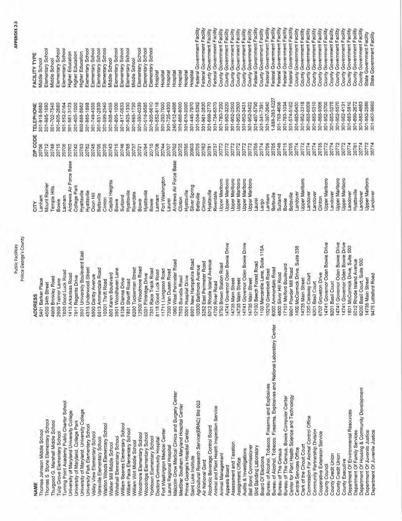


ADOPTED 2018 WATER AND SEWER PLAN
Chapter 2, Framework for Water and Sewer Planning
APPENDIX 2-4
Water Quality Criteria Prince George’s County
(State identified waterbodies & Tier II streams)

This page intentionally left blank


This page intentionally left blank