chapter-2 geographical profile of the study...
TRANSCRIPT
‘A Study of Tourism in Gujarat: A Geographical Perspective”
CHAPTER-2
GEOGRAPHICAL PROFILE OF THE
STUDY AREA
‘A Study of Tourism in Gujarat: A Geographical Perspective’
28
2.1 GUJARAT : AN INTRODUCTION
Gujarat has a long historical and cultural tradition dating back to the days of the
Harappan civilization established by relics found at Lothal(Figure-1).It is also called as
the “Jewel of the West”, is the westernmost state of India(Figure-2). The name
“Gujarat” itself suggests that it is the land of Gurjars, which derives its name from
‘Gujaratta’ or ‘Gujaratra’ that is the land protected by or ruled by Gurjars. Gurjars were
a migrant tribe who came to India in the wake of the invading Huna’s in the 5th century.
The History of Gujarat dates back to 2000 BC. Some derive it from ‘Gurjar-Rashtra’ that
is the country inhabited by Gurjars. Al-Beruni has referred to this region as ‘Gujratt’.
According to N.B. Divetia the original name of the state was Gujarat & the above-
mentioned name are the Prakrit& Sanskrit forms respectively. The name GUJARAT,
which is formed by adding suffix ‘AT’ to the word ‘Gurjar’ as in the case of Vakilat etc.
There are many opinions regarding the arrivals of Gurjars, two of them are,
according to an old clan, they inhabited the area during the Mahabharat period and
another opined that they belonged to Central Asia and came to India during the first
century. The Gurjars passed through the Punjab and settled in some parts of Western
India, which came to be known as Gujarat.Gujarat was also inhabited by the citizens of
the Indus Valley and Harappan civilizations. This was fortified by the excavations at
Lothal and Dholavira.
The signs of civilization in the Gujarat region dated back to the period from 3000
to 1500 BC. In the 3rd century BC under King Ashoka, the region was part of the
Mauryan Empire. The state saw various kingdoms like Mauryas, Guptas, Pratiharasetc,
but it was under the regime of Chalukyas (Solanki) when Gujarat witnesses progress and
prosperity. Inspite of the plundering of Muhammad Ghazni, the Chalukyan kings were
able to maintain general prosperity and well being of the state. After this glorious respite,
Gujarat faced troubled times under the Muslims, Marathas and the British rules.In 1818
AD, the British East India Company took control of Gujarat by administering the state
through local princely rulers. With the independence of India in 1947, Gujarat became
part of the state of Bombay. On 1st May 1960, Bombay state was split and Gujarat was
formed from the northern and western portions, which were predominantly Gujarati-
speaking areas. The remainder of Bombay state became the state of Maharashtra.
According to the census 2011, the state currently has 26 districts and 225 sub districts
encompassing 18,225 villages and 348 towns.

‘A Study of Tourism in Gujarat: A Geographical Perspective’
29
Figure 1:(The map showing early expansion of Indus Valley Civilization)1
The word ‘Gujarat’ gained currency during the Chaulukya period (942-1299
A.D.). Before this period parts of Gujarat were known as Anarta, Lata and Saurashtra.
North Gujarat from Abu up to Sabarmati River was known as Anarta. Latawas the
region between Narmada and Tapi and generally the whole southern Gujarat was known
as Lata. When the Muslim rule extended to southern Gujarat, the word Lata ceased to be
used. Kathiawar Peninsula was known as ‘Surastra’ and now it is called as Saurashtra.
Because of the predominance of Kathi tribes who opposed Marathas, they gave the name
Kathiawar to this peninsula. The whole mainland of Gujarat was known by this name
from thirteenth (13th) century onwards2.
Gandhinagar, the capital of Gujarat, lies on the banks of the Sabarmati River,
north of the former capital of Ahmedabad. Laid out in 30 residential sectors, in an ordered
style influenced by the work of Le Corbusier, who designed Chandigarh, its near-
symmetrical numbered streets are wide and strangely quiet, lined with a total of 16 lakh
trees. An expressway connects Gandhinagar with Ahmedabad.Gujarat is the birthplace of
many who played an important role in shaping modern India. Prominent among them are
ShriDadabhoyNavroji, the grand old man of the freedom fight, SardarVallabhbhai Patel,
1 The Map has been taken from an article published on website by Anil Mulchandani on the topic, “The Indus
Valley Civilization at Lothal. 2 ‘GujaratnoRajakiya and SanskriticItihas’, Vol.I. (1972), pp. 253-256, 274, 279-283.

‘A Study of Tourism in Gujarat: A Geographical Perspective’
30
an ‘Iron Man’ & the architect of a united India and Mahatma Gandhi, the father of the
Nation. These men carried the torch of national freedom and integration by infusing the
qualities of tolerance, brotherhood, non-violence and patriotism (Jingoism) amongst
Indians.
The Gujarat is one of the most prosperous states in the country, and considered to
be the most financially secure communities. In India and abroad, Gujarati’s with their
indomitable spirit have reputed among the world's premier business communities.One can
see the hardworking Gujarati’s operating hotels and motels in California, running stores
in Australia and New Zealand and newspaper kiosks in England & also engaged in
various jobs in USA and Canada. The most distinguished son of Gujarat was Mahatma
Gandhi who won for India its independence through non-violence movement. The
Gujarat is not a popular tourist destination for national & international tourists. Although
it is easy to travel to Gujarat during trips to Mumbai or Rajasthan, few people pause to
explore this very interesting part of India. Gujarat has the longest coastline in
India,stretching 1600 km, is dotted with 9 ports (including 1 international & 8 domestic).
In spite of possessing a variety of tourist attractions, state has not been able to
accelerate the pace of tourism in comparison to other states. In 1991, the state did declare
a tourism policy but it did not elicit adequate response from the private sector since the
policy contained only a handful of benefits while the implementation was tardy (belated)
due to legal and administrative constraints. This was at a time when the Government of
India had already declared tourism as an industry and a large number of states had
followed suit. This enabled the tourism industry to avail of incentives, reliefs & benefits
available to the industry in those states.
Figure 2-Geographical Location of Gujarat in the world map
‘A Study of Tourism in Gujarat: A Geographical Perspective’
31
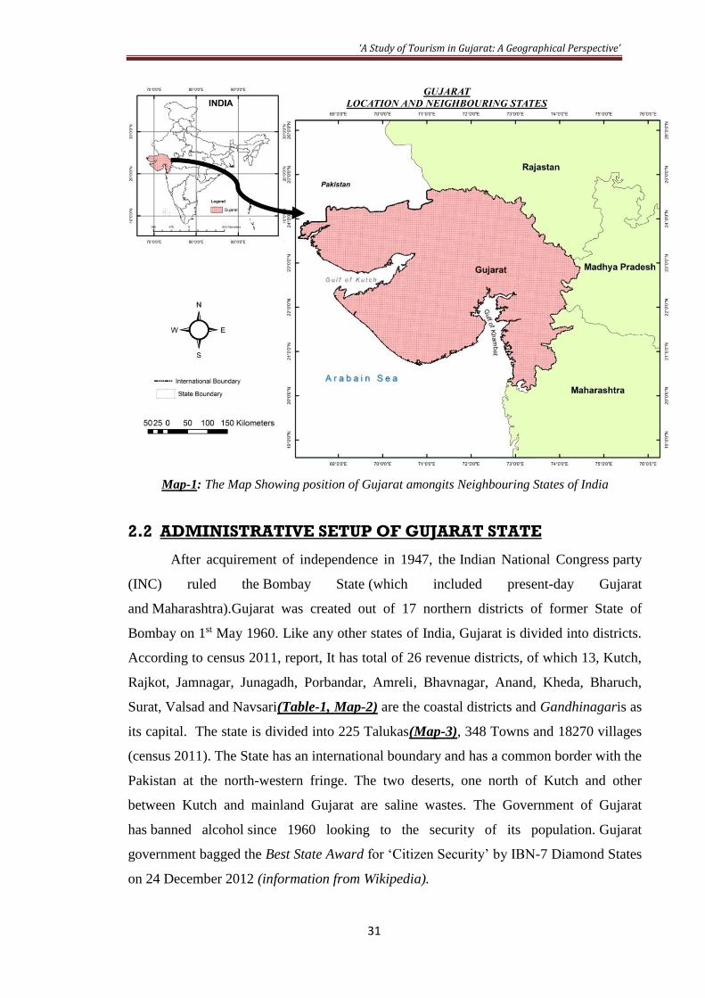
Map-1: The Map Showing position of Gujarat amongits Neighbouring States of India
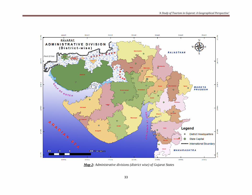
2.2 ADMINISTRATIVE SETUP OF GUJARAT STATE
After acquirement of independence in 1947, the Indian National Congress party
(INC) ruled the Bombay State (which included present-day Gujarat
and Maharashtra).Gujarat was created out of 17 northern districts of former State of
Bombay on 1st May 1960. Like any other states of India, Gujarat is divided into districts.
According to census 2011, report, It has total of 26 revenue districts, of which 13, Kutch,
Rajkot, Jamnagar, Junagadh, Porbandar, Amreli, Bhavnagar, Anand, Kheda, Bharuch,
Surat, Valsad and Navsari(Table-1, Map-2) are the coastal districts and Gandhinagaris as
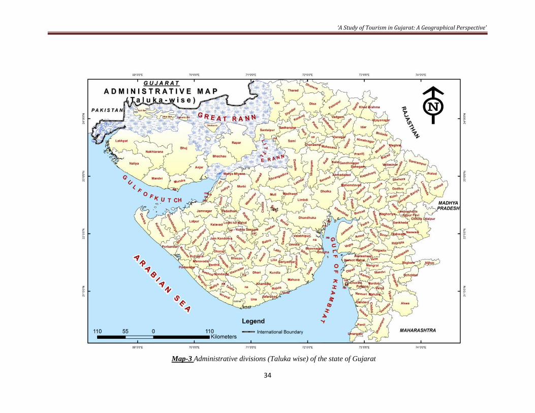
its capital. The state is divided into 225 Talukas(Map-3), 348 Towns and 18270 villages
(census 2011). The State has an international boundary and has a common border with the
Pakistan at the north-western fringe. The two deserts, one north of Kutch and other
between Kutch and mainland Gujarat are saline wastes. The Government of Gujarat
has banned alcohol since 1960 looking to the security of its population. Gujarat
government bagged the Best State Award for ‘Citizen Security’ by IBN-7 Diamond States
on 24 December 2012 (information from Wikipedia).
‘A Study of Tourism in Gujarat: A Geographical Perspective’
32
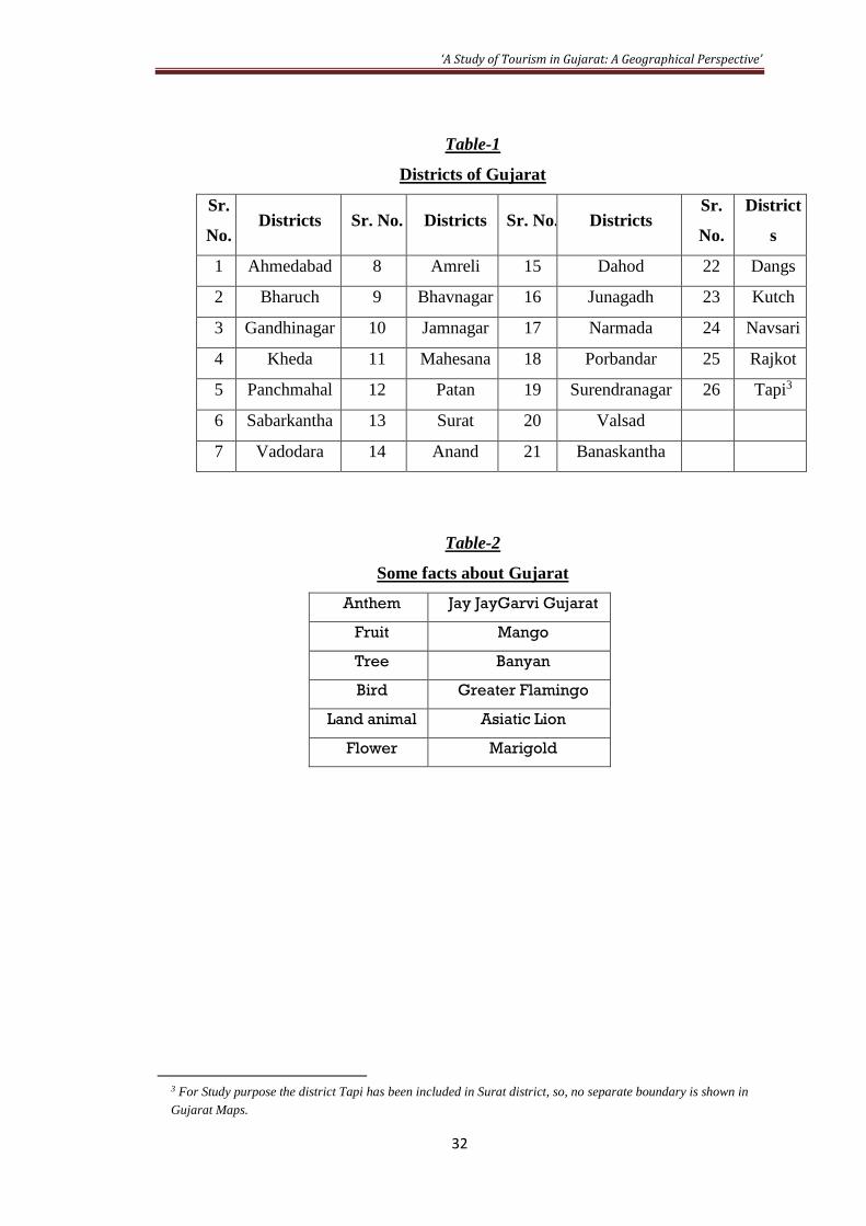
Table-1
Districts of Gujarat
Sr.
No. Districts Sr. No. Districts Sr. No. Districts
Sr.
No.
District
s
1 Ahmedabad 8 Amreli 15 Dahod 22 Dangs
2 Bharuch 9 Bhavnagar 16 Junagadh 23 Kutch
3 Gandhinagar 10 Jamnagar 17 Narmada 24 Navsari
4 Kheda 11 Mahesana 18 Porbandar 25 Rajkot
5 Panchmahal 12 Patan 19 Surendranagar 26 Tapi3
6 Sabarkantha 13 Surat 20 Valsad
7 Vadodara 14 Anand 21 Banaskantha
Table-2
Some facts about Gujarat
Anthem Jay JayGarvi Gujarat
Fruit Mango
Tree Banyan
Bird Greater Flamingo
Land animal Asiatic Lion
Flower Marigold
3 For Study purpose the district Tapi has been included in Surat district, so, no separate boundary is shown in
Gujarat Maps.
‘A Study of Tourism in Gujarat: A Geographical Perspective’
33
Map 2: Administrative divisions (district wise) of Gujarat States
‘A Study of Tourism in Gujarat: A Geographical Perspective’
34
Map-3 Administrative divisions (Taluka wise) of the state of Gujarat
‘A Study of Tourism in Gujarat: A Geographical Perspective’
35
2.3 GEOGRAPHICAL SETTING OF THE STUDY AREA
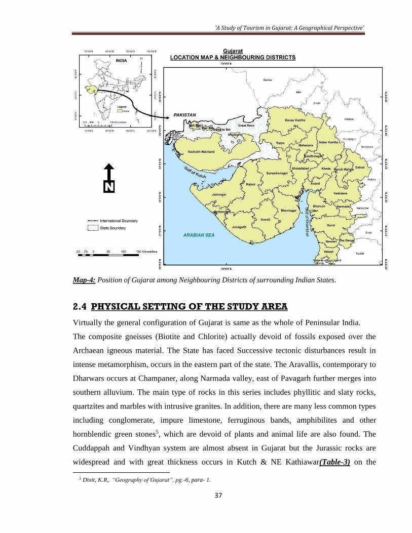
The State of Gujarat is situated on the west coast of the Indian Peninsula. It is
extended between 20º 02’ N and 24º 39’ N latitudes, and 68º 10’ E and 74º 37’ E4 longitudes.
Its establishment as a State of the Indian Union completed on 1st May, 1960, after separation
of Bombay into Gujarat and Maharashtra with occupied area is 196,024 square km. The best
time to visit the state is October through March. The state is further divided into 26 sub-
regions (Districts) for administrative purpose. The state is the sixth largest economy in the
country. Relatively, the State is bounded in the west by the Arabian Sea, on the north-west by
Sindh (Pakistan), by Rajasthan on the north & north-east by Madhya Pradesh and
Maharashtra (Map-1)on the east and by Nasik district on the south, by ‘Konkan’
(Maharashtra) on the south east & Union territories of Diu, Daman, Dadra and Nagar Haveli
to the south. Forests and hills of Vindhyas, Satpuras&Sahyadri lie on the eastern border
while mount Abu and the outliers of Aravalli range forms the border in the north. The river
Damanganga once formed the southernmost limit of Gujarat.
The state’s 1600 km (994 miles) coastline has attracted the sea-farers through the
ages, lured by the rich prospects of trade. The Arabs Portuguese, Dutch. Mughals and British,
as well as Parsis fleeing their native Iran, have all left their mark on Gujarat culture. The
major languages spoken are Gujarati, Marathi, Hindi& English.
The sparkling Arabian Sea at its verge by its gentle touch makes the hot sands blush.
The astounding beauties of the State can be witnessed in the areas of Kutch and Bhuj. The
sunlight makes a netted sunbeam dance over its shimmering silver sands. In the Gir Forest
the 'Kings of the Jungle', Lions crouch to maintain their privacy that is hampered by the
visitors. The temples of Gujarat that are emblem of rich cultural tradition by the fragrance of
incense sticks and chanting of mantras spread peace and unique euphoria.
Table-3
PHYSIO-GEOGRAPHIC ZONES (1991)
Divisions (Micro) Total/ Area in Districts/
4 “India Guide Gujarat”, edited by Desai, Anjali H., published by India Guide Publications, ISSBN 978-0-9789517-
2-6 (2011) pg.-17.

‘A Study of Tourism in Gujarat: A Geographical Perspective’
36
Sq. Km
Rural/ 1991 (States/
Urban Union
Territories)
Regions (Macro): The Coastal Plains and Islands
Sub-Regions (Meso): Gujarat Region
Gujarat Plain
Total 75966
Ahmadabad, Bharuch,
BanasKantha, Gandhinagar
Kheda, Mahesana,
SabarKantha, Surat, Vadodara
Valsad, Daman and Dadra &
Nagar Haveli (Gujarat, Dadra
& Nagar Haveli U.T. and
Daman & Diu U.T)
Rural 73649.15
Urban 2316.85
Eastern Hilly
Region
Total 10630 PanchMahals and the Dangs
(Gujarat)
Rural 10510.55
Urban 119.45
Kathiawar -
Peninsula
Total 64379 Amreli, Bhavnagar, Jamnagar,
Junagadh,
Surendrenagar, Rajkot and
Diu
(Gujarat and Daman & Diu
U.T.)
Rural 61997.45
Urban 2381.55
Kutch - Peninsula
Total 45652 Kutch (Gujarat)
Rural 45302.48
Urban 349.52
Source: Population Atlas India, Census of India 1991.
‘A Study of Tourism in Gujarat: A Geographical Perspective’
37
Map-4: Position of Gujarat among Neighbouring Districts of surrounding Indian States.
2.4 PHYSICAL SETTING OF THE STUDY AREA
Virtually the general configuration of Gujarat is same as the whole of Peninsular India.
The composite gneisses (Biotite and Chlorite) actually devoid of fossils exposed over the
Archaean igneous material. The State has faced Successive tectonic disturbances result in
intense metamorphism, occurs in the eastern part of the state. The Aravallis, contemporary to
Dharwars occurs at Champaner, along Narmada valley, east of Pavagarh further merges into
southern alluvium. The main type of rocks in this series includes phyllitic and slaty rocks,
quartzites and marbles with intrusive granites. In addition, there are many less common types
including conglomerate, impure limestone, ferruginous bands, amphibilites and other
hornblendic green stones5, which are devoid of plants and animal life are also found. The
Cuddappah and Vindhyan system are almost absent in Gujarat but the Jurassic rocks are
widespread and with great thickness occurs in Kutch & NE Kathiawar(Table-3) on the
5 Dixit, K.R,. “Geography of Gujarat”, pg.-6, para- 1.

‘A Study of Tourism in Gujarat: A Geographical Perspective’
38
Dhrangadhara plateau6. The discovery of Jurassic dinosaur eggs indicates the well existence
of Jurassic era. During the close of the Cretaceous the enormous outpouring and
solidification of lava form extensive trap covering the whole of Kathiawar and eastern
margin of south of Narmada. The thickness of this trap in Gujarat varies between 1000 and
3000 feet. During Pleistocene the recent formation such as the lithification of calcareous
rocks, coral reefs etc. occurred. The Quaternary period is marked by the upliftment of
continental shelf in Kutch.
The physiography of Gujarat shows a variety of physical features from mountainous
highlands to coastal lowlands. The varied landscape, beautifully branched drainage system,
inconsistence soil deposition & type of vegetation cover make it impressively different from
other states of India. Gujarat State spread over a vast area &physiographically, it is divisible
into three well defined regions, namely: The mainland that extends from the Rann of Kutch
and the Aravalli hills to the river Damanganga, The Peninsula, which is also known as
Saurashtra, is essentially a hilly tract & finally the Kutch, which is barren and rocky with
large patches of salt tract, further it is divided into the Great and Little Rann.
Most of the land of Gujarat is dry and arid in nature on account of nearness to Thar
Desert. It consists of four broad zones viz., (i) the Upland zone (hilly area), (ii) the Pediment
Zone with a thin sediment cover, (iii) the Basinal Zone and (iv) Coastal Zone7.(Map-5) The
Hilly Zone comprises the highlands of Aravallis&Vindhyans, which practically forms a
water divide for river flowing into the Arabian Sea &Rann of Kutch. The Pediment Zone is
the prominent feature bordering the hilly areas. The Basinal Zone is mainly a featureless
plain area. It includes the Aeolian landforms of north Gujarat and small hilly areas in the
north. The coastal zone includes broad estuarine inlets, mudflats, mangrove swamps, salt-
marshes and other associated features of the Narmada, Tapi, Mahi, Sabarmati rivers.
(Mathur, 2005) The Saurashtra peninsula forms watershed of almost all the radially flowing
rivers, falls into Arabian Sea. The highlands of Kathiawar have resulted from the denudation
of the basaltic plateau8. The Chotila hill forms the highest topographic feature in north (340
m AMSL). More rugged topography occupied part of Sabarkantha, Panchmahals, Baroda,
6Dixit, K.R., “Geography of Gujarat”, pg.-7 para 2. 7Mathur, U.B., (2005), “Quaternary Geology, Indian Perspective”, Geological Society of India, Bangalore, pp. 243. 8Dixit, K.R., “Geography of Gujarat”, pg.-19 para 2.

‘A Study of Tourism in Gujarat: A Geographical Perspective’
39
Surat and Bharuch districts, include Vanmala, Rajpipla, Satpura, Ratanmal and Pavagadh
hills.
Moreover, the topography of Gujarat is characterized by the small hilly tracts
especially around the Rann of Kutch region consists of five broad zones viz., The Hilly Zone,
the Pediment Zone, the Alluvial Plain, Banni Plains, Mud Flats and the Coastal Zone. The
Kaladungar hill in the Pachcham Island forms the highest point (465 m AMSL). The Banni
Plain is salt affected plain with low tableland and sparsely distributed grasses and bushes.
The plain is well demarcated by its confinement between the coastal marshes on the west and
a rupture slope on the east rising up to the mountains9. The today’s plains are mostly has
alluvial deposition brought by rivers of Sabarmati, Mahi, Narmada and Tapi. They are
broader in north & tapers towards south. Thus, it can be concluded that the topography of
Gujarat is divided into many regions based on the texture of the land and its geographical
features.
Map-5: Physiographic divisions of the Gujarat State.
9Dixit, K.R., “Geography of Gujarat”, pg.-16 para 2.
‘A Study of Tourism in Gujarat: A Geographical Perspective’
40
2.4.1 CLIMATE
The Gujarat state is situated along the Tropic of Cancer (crossing northern Gujarat)
with low land relief in most partsfalls in the sub-tropical climatic zone and has a varied
climate. The state experiences extreme type of climate. The summer season temperature are
high and vary from 27°C & 42°C10 and have been known to reach as high as 48°C, while the
winter temperature vary from 14°C to 29°C 11 , although freezing levels have also been
recorded in the state. The rains are moderate to heavy between June and September. The
northwestern part (semi-desert Kutch) of the state is dry, with less than 500 mm rain a year.
In the southern part (Table-4)of Gujarat, rainfall averages 2000 mm a year. The district
Dangs records highest average of about 190 cm. All over the state the average rainfall varies
from 33 to 152cms. Some areas in Ahmedabad, Mehsana, Banaskantha, Panchmahals,
Surendranagar, Jamnagar and Kutch districts face chronic shortage of water because of
inadequate rains. These factors account for the wide diversity in the climate of Gujarat. Due
to proximity to Arabian Sea, the climate of Gujarat is mainly moist in the southern districts
as compared to north because of adjoining desert. In Gujarat, a year can be roughly divided
into the winter season (November to February), summer season (March to May), southwest
monsoon season (June to September), and the transitional month of October. Best time to
visit is October to March.
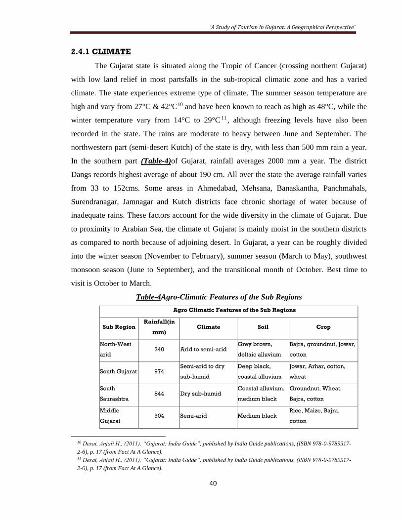
Table-4Agro-Climatic Features of the Sub Regions
Agro Climatic Features of the Sub Regions
Sub Region Rainfall(in
mm) Climate Soil Crop
North-West
arid 340 Arid to semi-arid
Grey brown,
deltaic alluvium
Bajra, groundnut, Jowar,
cotton
South Gujarat 974 Semi-arid to dry
sub-humid
Deep black,
coastal alluvium
Jowar, Arhar, cotton,
wheat
South
Saurashtra 844 Dry sub-humid
Coastal alluvium,
medium black
Groundnut, Wheat,
Bajra, cotton
Middle
Gujarat 904 Semi-arid Medium black
Rice, Maize, Bajra,
cotton
10 Desai, Anjali H., (2011), “Gujarat: India Guide”, published by India Guide publications, (ISBN 978-0-9789517-
2-6), p. 17 (from Fact At A Glance). 11 Desai, Anjali H., (2011), “Gujarat: India Guide”, published by India Guide publications, (ISBN 978-0-9789517-
2-6), p. 17 (from Fact At A Glance).

‘A Study of Tourism in Gujarat: A Geographical Perspective’
41
North
Saurashtra 537 Dry sub-humid Medium black
Bajra, Jowar, groundnut,
cotton
South Gujarat
(heavy
rainfall)
1793 Semi-arid to dry
sub-humid
Deep black,
coastal alluvium
Rice, Ragi, sugarcane,
Jowar
North
Gujarat 735 Arid to semi-arid
Grey brown,
Coastal alluvium
Bajra, cotton, Jowar,
wheat
2.4.2 THE DRAINAGE SYSTEM
The Aravalli hills forms the main watershed for the rivers of north Gujarat. The Luni,
Banas, Saraswati, Khari, Rupen, and Sabarmati drain the plains and debouching into Rann of
Kutch and Gulf of Khambhat. The Luni forms the part of the mighty Saraswati(Welhelmy,
1969), which had its origin in the Himalayas. Today this river is dried up and lies buried
beneath desert sand. Banas River originates near Sirohi hills in southwestern Rajasthan.
Rupen, originates from the slopes of Tarangda Hills.
The Sabarmati is one of the important rivers of northern Gujarat, originating near
Mount Abu,(Map-6) flowing all through 400 km crossing Sabarkantha, Banaskantha and
Mahesana districts, carries water into Gulf of Khambhat. The Mahi is the third largest river
in Gujarat after Narmada and Tapi, originates in the Malwa plateau in Madhya Pradesh, run
for 550 km, through Panchmahal and Kheda districts (K. R. Dikshit). Narmada and Tapi are
the two important west flowing rivers and both originate in the Vindhyan Mountains.
Narmada flows for 1313 km and Tapi for 720 km before joining Arabian Sea. The main
tributaries of Narmada are Orsang&Karjan. As compare to Narmada, the river Tapi is a
smaller river but the area drained by it in Gujarat is large. The other important rivers draining
south Gujarat are Kim, Mindhola, Purna, Ambika. The Dhadhar and its tributary Vishwamitri
rise from near Pavagadh hills in Panchmahals.
The drainage of Saurashtra follows radial pattern, flowing out in all directions from
central highlands. The drainage pattern is controlled by two major hill ranges, viz., Mandva
range near Rajkot (383m AMSL) and Gir ranges in southern Saurashtra (higher than 390 m
AMSL). The Bhadar is the largest westerly flowing river (260 km) of Saurashtra. The
Shetrunji, The Machhu and The Aji are other important river of Saurashtra. The Kutch
drainage also shows radial pattern with central highlands forming main watershed towards
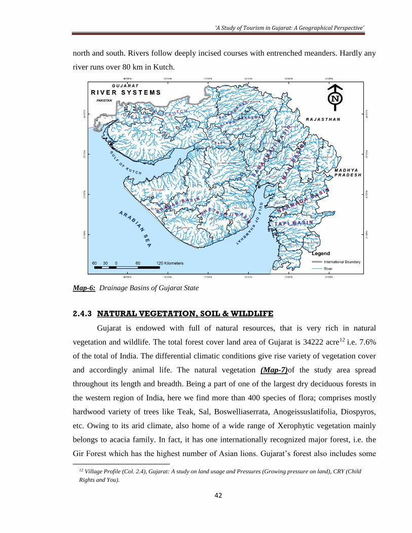
‘A Study of Tourism in Gujarat: A Geographical Perspective’
42
north and south. Rivers follow deeply incised courses with entrenched meanders. Hardly any
river runs over 80 km in Kutch.
Map-6: Drainage Basins of Gujarat State
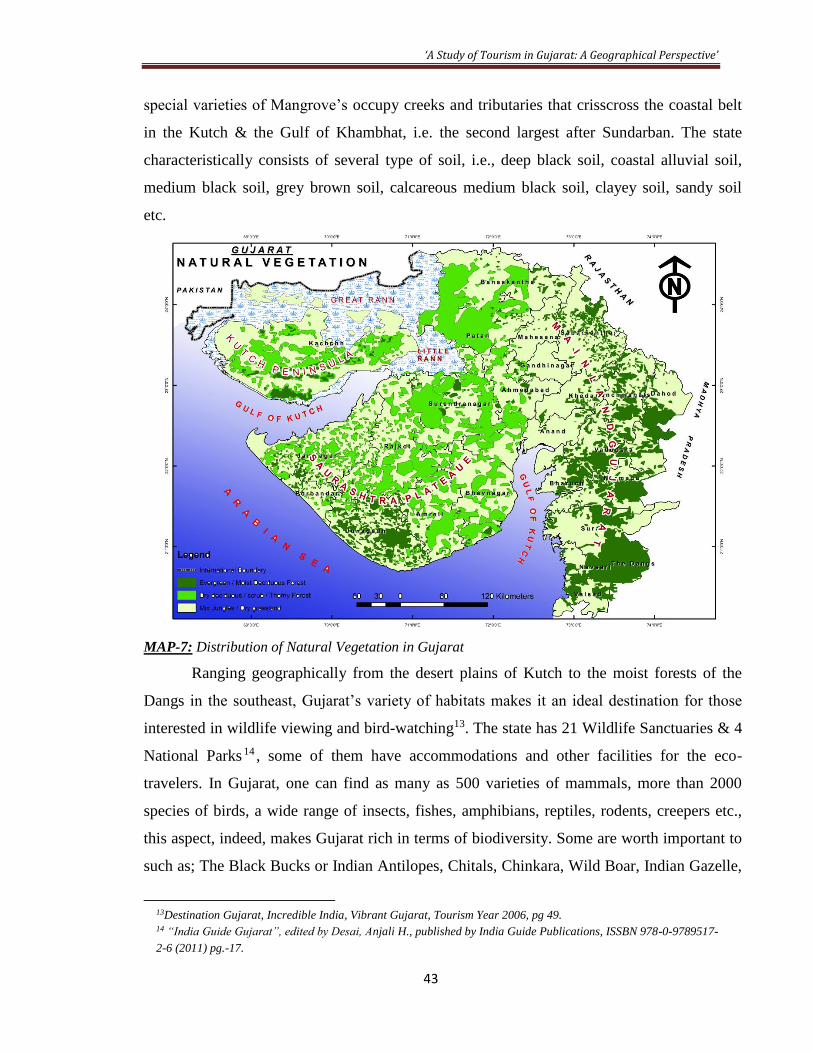
2.4.3 NATURAL VEGETATION, SOIL & WILDLIFE
Gujarat is endowed with full of natural resources, that is very rich in natural
vegetation and wildlife. The total forest cover land area of Gujarat is 34222 acre12 i.e. 7.6%
of the total of India. The differential climatic conditions give rise variety of vegetation cover
and accordingly animal life. The natural vegetation (Map-7)of the study area spread
throughout its length and breadth. Being a part of one of the largest dry deciduous forests in
the western region of India, here we find more than 400 species of flora; comprises mostly
hardwood variety of trees like Teak, Sal, Boswelliaserrata, Anogeissuslatifolia, Diospyros,
etc. Owing to its arid climate, also home of a wide range of Xerophytic vegetation mainly
belongs to acacia family. In fact, it has one internationally recognized major forest, i.e. the
Gir Forest which has the highest number of Asian lions. Gujarat’s forest also includes some
12 Village Profile (Col. 2.4), Gujarat: A study on land usage and Pressures (Growing pressure on land), CRY (Child
Rights and You).
‘A Study of Tourism in Gujarat: A Geographical Perspective’
43
special varieties of Mangrove’s occupy creeks and tributaries that crisscross the coastal belt
in the Kutch & the Gulf of Khambhat, i.e. the second largest after Sundarban. The state
characteristically consists of several type of soil, i.e., deep black soil, coastal alluvial soil,
medium black soil, grey brown soil, calcareous medium black soil, clayey soil, sandy soil
etc.
MAP-7: Distribution of Natural Vegetation in Gujarat
Ranging geographically from the desert plains of Kutch to the moist forests of the
Dangs in the southeast, Gujarat’s variety of habitats makes it an ideal destination for those
interested in wildlife viewing and bird-watching13. The state has 21 Wildlife Sanctuaries & 4
National Parks 14 , some of them have accommodations and other facilities for the eco-
travelers. In Gujarat, one can find as many as 500 varieties of mammals, more than 2000
species of birds, a wide range of insects, fishes, amphibians, reptiles, rodents, creepers etc.,
this aspect, indeed, makes Gujarat rich in terms of biodiversity. Some are worth important to
such as; The Black Bucks or Indian Antilopes, Chitals, Chinkara, Wild Boar, Indian Gazelle,
13Destination Gujarat, Incredible India, Vibrant Gujarat, Tourism Year 2006, pg 49. 14 “India Guide Gujarat”, edited by Desai, Anjali H., published by India Guide Publications, ISSBN 978-0-9789517-
2-6 (2011) pg.-17.
‘A Study of Tourism in Gujarat: A Geographical Perspective’
44
endangered Indian Wolf, four horned Antelope, Rusty Spotted Cats and more important the
Wild Ass. The Gujarat also has a number of global label (proposed in 2011 on World
Migratory Bird Day) wetlands such as; Wadhwana, NalSarovar, Thol, ChhariDhand,
Khijadia etc. which becomes the home of lakhs of migratory birds such as; Great Indian &
Macqueen’s Bustard, Flamingos, Storks, Ibises Spoonbills, Pelicans, Cranes etc. The wildlife
is well sheltered in a natural environment with proper care in the form of national parks (04)
and sanctuaries (21) such as; Gir Forest National Park & wildlife sanctuary, Blackbuck
National Park, Vansda National Park, Marine National Park, DevgadhBaria Bear sanctuary,
Wild Ass sanctuary etc. The Gujarat coast is also famous for breeding ground for some
endangered species such as Whale shark and Dugong.
2.5 DEMOGRAPHY
The people of Gujarat trace their lineage from the people originally known as Gujjars.
They are believed to have come to India with the Huns and while passing through Punjab,
settled in Gujarat. According to census 2011, Gujarat ranks 10th (4.99%) in population15, 9th
in area & 2nd in urbanization16 among the other states, union territories republics of India.
According to the latest census of 2011, the provisional estimation (because Gujarat was hit
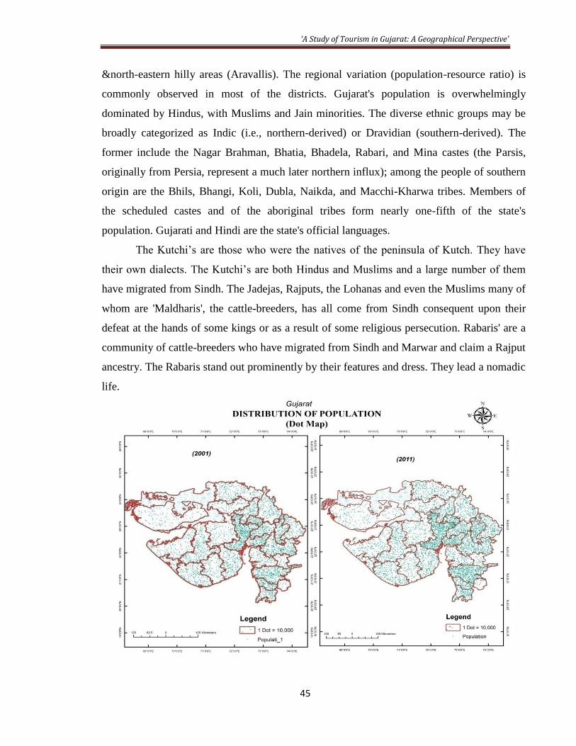
by earth quake, no survey was conducted) showed that the population (Map-8)of Gujarat is
approx. 6.03crores. The density of population(Map-9) of the state is also very high i.e. 308
persons/sq km. The decadal changes in population also have been significant in the state
(Map-10 & Map-11).In terms of literacy rate the state has gained its prestige by increase of
79.31% as compare to 69.14% in 2001. The big achievement is in high increase of female
literacy (70.73%) in the state which was 57.80% in 200117. The sex ratio of the population of
Gujarat state has worsened in that period. The number of females has come down to 918
from the 920 number recorded during the preceding census 18 . In terms of migratory
character, the Gujarati’s are among the top to foreign countries primarily to Canada & U.K.
Gujarat’s Non-Ecumene areas are confined partly to deserts (Great Rann) and northern
15 Gujarat Census, 2011, Table-1, Distribution of Population, Decadal Growth Rate, Sex-Ratio and Population
Density - Gujarat State 16PrabhudesaiArun “Urban India 2030” (in numbers) on April 4, 2010, Urbanized states, 2008. 17 Gujarat Census, 2011, Table-4, Literacy rate by sex for Gujarat State and District-2001 & 2011. 18 Gujarat Census, 2011, Table-1, Distribution of Population, Decadal Growth Rate, Sex-Ratio and Population
Density - Gujarat State
‘A Study of Tourism in Gujarat: A Geographical Perspective’
45
&north-eastern hilly areas (Aravallis). The regional variation (population-resource ratio) is
commonly observed in most of the districts. Gujarat's population is overwhelmingly
dominated by Hindus, with Muslims and Jain minorities. The diverse ethnic groups may be
broadly categorized as Indic (i.e., northern-derived) or Dravidian (southern-derived). The
former include the Nagar Brahman, Bhatia, Bhadela, Rabari, and Mina castes (the Parsis,
originally from Persia, represent a much later northern influx); among the people of southern
origin are the Bhils, Bhangi, Koli, Dubla, Naikda, and Macchi-Kharwa tribes. Members of
the scheduled castes and of the aboriginal tribes form nearly one-fifth of the state's
population. Gujarati and Hindi are the state's official languages.
The Kutchi’s are those who were the natives of the peninsula of Kutch. They have
their own dialects. The Kutchi’s are both Hindus and Muslims and a large number of them
have migrated from Sindh. The Jadejas, Rajputs, the Lohanas and even the Muslims many of
whom are 'Maldharis', the cattle-breeders, has all come from Sindh consequent upon their
defeat at the hands of some kings or as a result of some religious persecution. Rabaris' are a
community of cattle-breeders who have migrated from Sindh and Marwar and claim a Rajput
ancestry. The Rabaris stand out prominently by their features and dress. They lead a nomadic
life.

‘A Study of Tourism in Gujarat: A Geographical Perspective’
46
Map-8: Distribution of Population in Gujarat (both the above map)

‘A Study of Tourism in Gujarat: A Geographical Perspective’
47
Map-9:Density of Population of Gujarat

‘A Study of Tourism in Gujarat: A Geographical Perspective’
48
Map-10: Percentage Growth of Population in Gujarat

‘A Study of Tourism in Gujarat: A Geographical Perspective’
49
Map-11: Decadal change in population of Gujarat
‘A Study of Tourism in Gujarat: A Geographical Perspective’
50
2.6 CULTURE
The culture, as the whole way of life of a people, is both a part of nature and apart
from nature. Such ways of life are also usually well-adapted to their environment and are
easily seen as a part of nature. The Gujarati’s are known all over the world for their cultural
contribution. The contribution of oldest civilization is not untouched with Gujarat tourism
history. The state is steeped in tradition, where festivals abound. The folklore and folk
culture of Gujarat can be traced to the mythology of Krishna an incarnation of the God
Vishnu. Dances in honour of Krishna have survived in the form of the popular folk dance, the
'Garba'. A folk drama, the 'Bhavai', also has survived. On 14 January, every year on the day
of ‘Makar-sakranti’ Ahmedabad hosts an international kite festival. A three-day
extravaganza takes place towards the end of August every year at Tarnetar, 176 km from
Ahmedabad. And the most-eagerly awaited festival is Navaratri consisting of nine nights of
festivity when the entire state resounds with the beat of the dhol, cymbals, flute and the
thrilling wail of the shehnais. Every street and village square comes alive with men and
women, young and old, dancing the ‘raas-garba’ from late night to the wee hours of the
morning.
Gujarat is also famous for its art and craft products. The religion and religious
impulses have acted as a catalyst for producing the purest and intensely delightful art,
architecture, painting, poetry and music in Gujarat. Temples in the state, like anywhere else
in India, were built as abodes of Gods. All are sculptured with great design. The Shetrunjay,
Dilwara and Girnar are some of exclusive examples. Among the most durable and effective
of the state's cultural institutions are the trade and craft guilds known as 'mahajans', which
often solves disputes, acted as channels of philanthropy (humanity), and encouraged the arts.
The Gujarat’s cultural value is very high as its people have great strongholds on their cultural
heritage, festivals, fairs, songs etc.
2.7 ECONOMY OF THE STATE
Gujarat, located in the west of India, is the sixth (6th) largest economy in the country,
contributing 6.2% of India’s national income. It endowed with important economic resources
such as agriculture, minerals, marine, besides animal and human resources. In the past 50
years Gujarat, as a state, has been on the move. Looking back now, Gujarat has certainly

‘A Study of Tourism in Gujarat: A Geographical Perspective’
51
come a long way from where it was. The journey of Gujarat has been marked by several vital
transformations. Back in the 1960’s, the economy of Gujarat used to be driven by textiles. In
contrast, Gujarat’s economy today is being driven by a wide array of industries viz., salt,
diamonds, pharmaceuticals, chemicals, milk products and much more. Due to state’s poor
quality of soils, inadequate rainfall & drainage, frequent droughts and floods, and
underdeveloped irrigation facilities, the yield from agriculture is distressingly poor. But
agriculture & animal husbandry continues to be the primary occupation of the large majority
of its people (59.8%). The principal revenue generation from agriculture comes from the cash
crops such as castor, cotton, tobacco & groundnuts. Gujarat is also well known for its success
in dairy cooperatives, owned by the GCMMF. The diary industry has made tremendous
advance and the now the accounts for major percentage of infant milk produced in the
country19. The economy of Gujarat is one of the most prosperous state economies within the
Indian Republic. After the division & formation of the new State, industrial development has
also taken rapid rate. The natural entrepreneurship of the native Gujaratis has led to an
enviable resurgence of the industrial economy, which makes it ranked just behind
Maharashtra in manufacturing gross state domestic product (GSDP)20.
The economy of the state is highly industrialized, although dominated by service
sector, which contributes 43.3% of the GSDP. The largest component in this sector is trade,
hotels, restaurants, banking and financial facilities. There has been impressive development
of mineral based mining industries (4% of the state’s income), such as limestone, marble,
lignite, bauxite, china clay & granite; besides oil and natural gas. The graph of annual growth
succeeded every year except during droughts, industrial recession and earthquakes, that
disrupted the economy. Business & financial acumen, industry and thrift are the three
principal characteristics, which discern the residents of this part of the country. The per
capita income is among the highest among the large states of India. Almost 14.07% lives
BPL, which is much lower than the national average of 26.1% (2005-06). The long coastline
facilitates trade have enabled Gujaratis to carry on brisk maritime trade with foreign
countries since ancient times. Even now many people from this part of the country have
settled for business reasons in other parts of the country and abroad. Today, Gujaratis have
19Rahman S.A., (editor-in-chief) (2005), “The Beautiful India”, p. 4, para-3. 20 Kale S., Bhandari L., “Gujarat, Performance, Facts and Figures”, edited, State at a Glance 2006-07, A PHDCCI
initiative, pp 11.

‘A Study of Tourism in Gujarat: A Geographical Perspective’
52
penetrated in the countries of East and South Africa, Aden, New Zealand, U. K and U. S. A,
In view of these connections the residents here have a cosmopolitan and noninterventionist
outlook.
Besides Industries the tourism also has contributed a lot in development of the state.
The entrepreneurship skill of the Gujarati people has led them to become economic
developers and marketers also. In areas of the world where the Industrial Age has ended,
there is only a semantic distinction between tourism developers and economic developers, in
terms of how they function to serve prospects. Most people worldwide still think of
economic development in terms of industrial development. Separating economic
development activities into "industrial" or "tourism" is of little importance until it causes
confusion for those who own opportunities and have decisions to make that affect locations
or expansions and start-ups21. Entrepreneurs are more likely to be involved in tourism-related
product development. In addition to entrepreneurs, investors and property or project
developers are generally what make up a "whole" tourism-related prospect.
2.8 MAJOR ATTRACTIONS OF THE STUDY
Gujarat has tremendous prospective for developing all domestic, national and
international tourism. There is everything that provides such opportunities: vast territory, rich
historical and cultural legacy, in some regions virginal locations. The variety of landscape
provides for development of different types of tourism. There are number of hotels and
resorts almost all over the state, which makes Gujarat a good place to enjoy beach recreation
and health recreation at seas. One could enjoy by taking ethnic tours to different areas in the
state.
Any kind of mountain tourism (alpinism, speleo-tourism, hiking, rafting in
“turbulent” mountain rivers, mountain biking and hang-glider riding) is possible to do in the
state. One can also visit health recreation resorts in the areas of water springs. The full-
flowing and long rivers, such as the Narmada, Tapi and Sabarmati seem to have been created
for fishing, rafting, riding catamarans and boating. The long coastline surrounded from west,
south of the state offer cruises for tourists. Numerous lakes at some places (mostly Saputara)
21 Glover Bob, article on ‘Tourism as Economic Development’ A Brief Guide for Communities and Enterprise
Developer.

‘A Study of Tourism in Gujarat: A Geographical Perspective’
53
are visually more appealing and impressive. Water in these lakes is not only pure but one can
drink.
Forests of south central and south Gujarat are full of birds and animals (biodiversity).
This fact attracts many educational and naturalist tourists. There are many areas of the
untouched and virginal nature. That is where ecologic tours are best. The Gir Forest is the
only natural habitat for Asiatic lions, where one does not meet any personal cars driving
along a forest for several hours. However, it is very likely that one will see a wild Bears
among the trees in Panchmahal area of Dahod district. An interested tourist will point out
rare migratory birds such as flamingos, pelicans and other at different wetlands. None of
those who are fond of adventure tours left untouched by paragliding in the fabulous region of
Dang’s district.
The reputation of Gujarat is famed all over the world as a popular tourist destination
of optimum class and high quality. It provides to keep that impression alive in the hearts of
its thousands of tourists. It is famous for its temples, beaches, wildlife, national parks, hill
stations, festivals and all other types of tourist attractions. Gujarat is also famous all over the
world for its exceptional cuisine. It's not one of India's most regular visited regions, but has
long been an important centre for Jains. It is one of India's wealthiest states, supporting
modern industrial complexes as well as thriving village handicrafts. The last Asiatic lions are
here, and the pleasant beaches make for a good evening.
Gujarat with its immense tourism has unending list of tourist destinations, right from
Ahmedabad- the Manchester of India, Gandhiji'ssabarmati Ashram, spectacular peninsula of
Saurashtra, the historic Jain Temple of Palitana, SasanGir the last natural habitat of majestic
Asiatic lions, the coastal towns of Porbandat and Dwarka the semi-inland of Kutch etc, the
list is unending.
Various fairs and festivals are celebrated in every month in Gujarat. Some of the main
festivals which are celebrated in Gujarat are the Kite Flying Festival or MakarSankranti,
Navaratri Festival, Dang Darbar and three day Tarnetar Fair. Each year in January different
venues decided for IKF competition to promote that particular area through the kite festival22.
Apart from this the Modhera Dance Festival in January, the Kutch Rannotsav in
22MittraVipul, Secretary Tourism, Gujarat, during a press conference held in Mumbai to promote IKF on Jan 5,
2010.

‘A Study of Tourism in Gujarat: A Geographical Perspective’
54
February/March, Bhavanath Fair (Junagadh), Chitra-Vichitra fair in March, Janmashtami in
August, BhadraPurnima at Ambaji in September, Shamlaji Fair in November &Somnath Fair
in November/December are peculiar in its cultural characteristics.
The handicrafts of the Gujarat are also unique like the Gujarati cuisine. Craftsmen
and women who left their villages to work as stone crushers for the living have been brought
back to practice their traditional arts. Their products are also available & can be purchased
from Gujarat emporiums in Ahmedabad, Delhi and Mumbai. Besides these, the Patola silk
saris are another famous item of Gujarat that are extremely fine and quite expensive and
made by very small master craftsmen at Patan. The zari or gold thread embroidery work
comes from Surat. Jamnagar in Saurashtra is known for its woolen shawls, blankets, rugs,
wooden chest and traditional furniture. Gujarat is also known for the famous and unique
Kutch embroidery.
There are about four national parks and twenty one wildlife sanctuaries in Gujarat.
Some of the wildlife sanctuaries and national parks are the Marine National Park at
Jamnagar, Gir National Park at Junagadh, Indian Wild Ass Wildlife sanctuary at Kutch,
Velavadar National Park at Bhavnagar. Nalsarovar, Khijadia Bird Sanctuary at Abmedabad
and the Porbandar Bird sanctuary are the other bird sanctuaries in different districts of
Gujarat.
Some of the famous cities in Gujarat are Ahmedabad, Bhavnagar, Gandhinagar,
Junagadh, Somnath, Surat, Dwarka, Porbandar and Vadodara, have an archaeological,
historical and cultural and architectural importance. Many fine examples of Muslim
architecture found in Ahmedabad. Baroda was the capital of the princely state of Gaekwad.
Apart from natural, the historical and cultural factors that contribute to development
of foreign tourism in Gujarat. For example the State has introduced ‘Walk in the Ashram’
tours in Sabarmati ashram, which has a historical connection with Mahatma Gandhi. Foreign
and domestic tourism in the state is characterized by variety of its types. Such types as
ecologic, sport, extreme tourism, mountain touring, cognitive tourism, business tourism,
health recreation tourism, cruising & fishing, event tours and gastronomic tourism are
developing most rapidly. Such types as individual tours and youth tourism are also becoming
more popular now days.

‘A Study of Tourism in Gujarat: A Geographical Perspective’
55
In spite of possessing a variety of tourist attractions such as wildlife, scenic beauty,
pilgrimage centres, exotic traditional crafts, beaches and a varied healthy and tasteful cuisine,
the State has been ranked number 7 in terms of tourist arrivals in India. The State can
accelerate the pace of tourism development by improving the tourism infrastructure and
aggressively promoting tourism in India and outside. In recent years, Gujarat has faced
increased competition from other states who have aggressively promoted tourism e.g.:
Kerala- “Gods Own Country” and “Maharashtra Unlimited” campaign23.
Besides all above mentioned tourist attractions the activities like religious and
archeological tourism, heritage, corporate tourism, coastal and beach tourism, medical
tourism, adventure tourism, highway tourism etc. are being encouraged in certain areas. The
State thus offering a new scope for investment in tourism related activities in the form of
accommodation projects, food oriented projects, amusement parks and water sports,
handicraft village complexes, sea/river cruise, safari project, sports/health facility complexes,
etc. The Government would also like to encourage service-oriented projects like travel
operation, tour operation, transport operation, etc.
Gujarat had a strong tourism base dating from Jurassic era to modern times, the
dinosaur fossils at Balasinor and Kutch and the Indus Valley sites of Lothal and Dholavira,
the natural beauties of unindulged golden sand beaches and having the vast modern life like
dolphins, whale-sharks and other mammals, excellent heritage sites and religious places like
Somnath, Dwarka, Ambaji, Pavagadh, Palitana etc., the huge scenic beauties of hills and
mountains of Saputara, Taranga, Girnar, Wilson Hill and Jessor Hill, rich wild-life
sanctuaries of Asiatic lion, leopard, tigers, sloth bear, wild ass, wolf, Indian Bustard,
flamingos and pelicans, historical monuments like Patan’sSahashtralingh Lake and
RankiVav, AdalejVav, Modhera Sun Temple, VadnagarToranetc24. All this shows the real
attractive potential of Gujarat tourism. The specialty of Kutch District of Gujarat has to be
put to the optimum use on the tourism sector. The district has the distinct features of sea and
desert in the same district and the rich dinosaur fossils. There is a good scope for exploiting
these indigenous resources for the development of Tourism sector in Gujarat
23A discussion note on “Accelerating Growth in Gujarat” by KPMG in India, pg. 19. 24 Tourism Policy 2003-10, Tourism at a Glance, A Global Scenario, B., Industries, Mines & Tourism Department
Government of Gujarat