chapter 2 geography and environment -...
TRANSCRIPT
39
Chapter 2
Geography and Environment
Arunachal Pradesh shows a wide variation in the topography of the land .The topography of
Arunachal Pradesh is characterized by an undulating hilly terrain, towering hill slopes,
enthralling river valleys and imposing peaks. For a very long time the region remained
remote from mainstream India due to its location in difficult terrain with impenetrable
vegetation.
2.1. Topography
Topography wise Arunachal Pradesh has been divided into 4 distinct physiographical
divisions:
1. The Himalayan Ranges
2. The Mishmi Hills
3. The Naga-Patkoi Ranges and
4. The Brahmaputra Plains
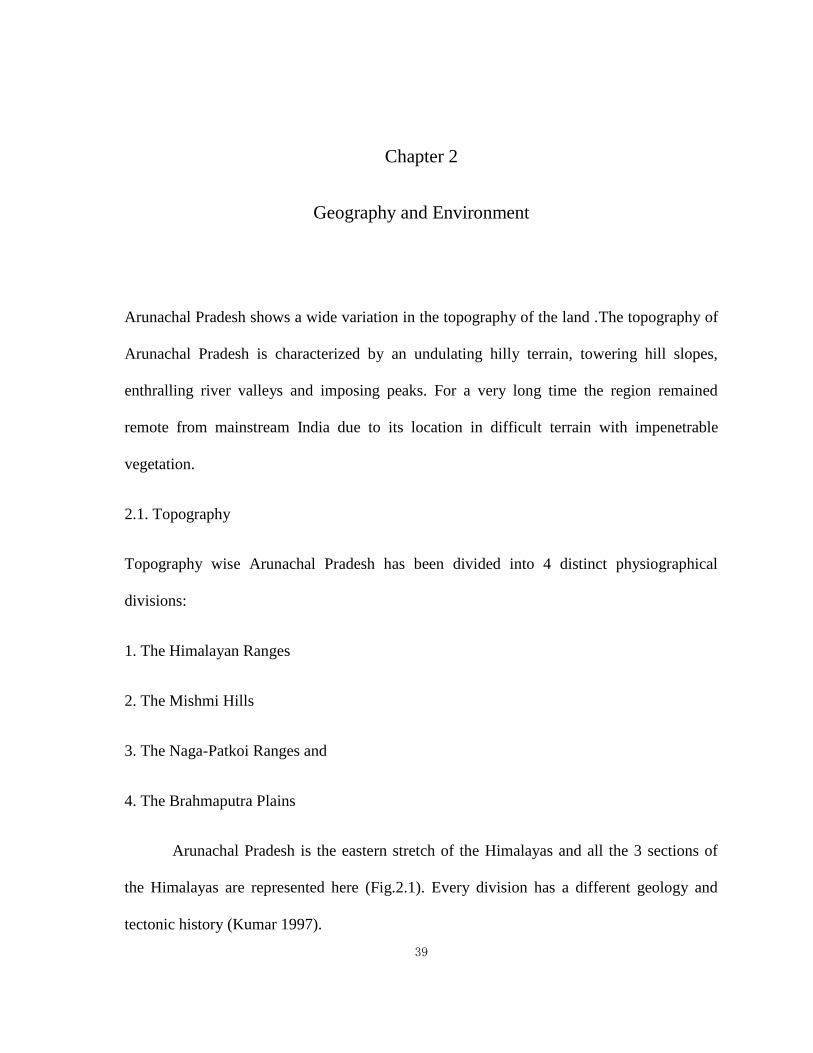
Arunachal Pradesh is the eastern stretch of the Himalayas and all the 3 sections of
the Himalayas are represented here (Fig.2.1). Every division has a different geology and
tectonic history (Kumar 1997).
40
Fig. 2.1: Shows the Physiographic divisions of Arunachal Pradesh
From the Brahmaputra Plains at an average elevation of 100m, the Himalayas attain
an elevation of 7089m. The Himalayas can be further sub-divided into physio-tectonic
Zones:
(i) The sub-Himalayan zone rising abruptly from the Brahmaputra Plains along a
tectonic plane-the Foot Hill Fault. It is about 10 -20 km wide but narrows down to 1 -2 km
in the Dibang valley.
(ii) The lesser or Lower Himalayas: Elevation 2500-4000 m and 80-90 km wide. Take a
syntaxial bend towards SE to abut against Mishmi Hills. Its southern limit is defined by the
Main Boundary Fault/Thrust.
41
(iii) The Greater or Higher Himalayas. A zone of very high relief with heights greater
than 6000m having precipitous slopes and deep gorges. This zone is generally devoid of
vegetation. Its southern limits are defined by the Main Central Thrust.
(iv) Trans-Himalayan Tibetan or the Thethyan zone: It is the northernmost zone which is
about 30-40 km wide and of low relief (Elevation 3000 – 6000m). All important Passes are
located in this zone (Preliminary Feasibility Report on 1120 MW Bhareli- H.E. Project, Ar.
P, 2003).
The Eastern Himalayas that cover 18,518 sq. km area of East and West Siang
districts is almost wholly a rugged mountainous terrain extending over the central region of
Arunachal Pradesh.
The region has been described as ‘an intricate labyrinth of precipitous, rocky and
high hills and mountains, with beautiful green valley’s drained by innumerable rivulets and
mighty rivers cascading down from upper elevations. The tangle of hills and mountains
throwing a series of spurs and towering to majestic heights of eternal snow is the most
imposing topographic feature of Siang. The elevation of the hills varies from 305 to 3050 m.
The tract to the right of the Siang River is less hilly than the area lying between the Siang
and Dibang, which has mountains rising from 3050 to 4572 m. There are lofty snow-clad
mountains in the north. Strips of flat land are interspersed in the riverine tracts, of which the
most prominent is the level area of Pasighat. The hills are docked with wooded forests. The
lower regions and the foothill areas adjacent to the plains of Assam have a luxuriant growth
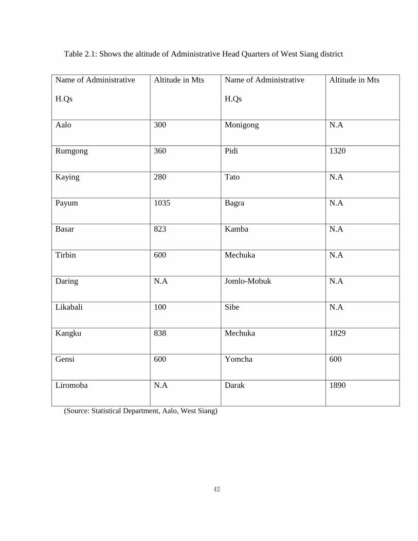
of vegetation with tall trees and thick undergrowth of scrubs (Choudhury1994) (Table 2.1).
42
Table 2.1: Shows the altitude of Administrative Head Quarters of West Siang district
Name of Administrative
H.Qs
Altitude in Mts Name of Administrative
H.Qs
Altitude in Mts
Aalo 300 Monigong N.A
Rumgong 360 Pidi 1320
Kaying 280 Tato N.A
Payum 1035 Bagra N.A
Basar 823 Kamba N.A
Tirbin 600 Mechuka N.A
Daring N.A Jomlo-Mobuk N.A
Likabali 100 Sibe N.A
Kangku 838 Mechuka 1829
Gensi 600 Yomcha 600
Liromoba N.A Darak 1890
(Source: Statistical Department, Aalo, West Siang)
43
2.2. Physiography
The area under study is lying in the Lower Himalaya region. The trend of hill ranges in
Siang valley is mostly North East-South West to North South. The area is highly jagged and
the hill slopes are usually steep. The flat alluvial tract lies to the south of Pasighat foothills.
The Siang River forms a deep gorge cutting across the sub-Himalayan ranges in Northwest
to Southeast direction and upstream wards swings into North-South direction across the
inner ranges of the Lower Himalaya.
2.3. Drainage
Rivers constitute an important part of the topography of the state. Arunachal Pradesh is
divided into five major river valleys:
1. The Siang Valley
2. The Kameng Valley
3. The Subansiri Valley
4. The Lohit Valley and
5. The Tirap Valley
These valleys are named after the important rivers of the state. The major rivers and
their tributaries traversing the state are Siang, Kameng, Subansiri, Subansiri, Lohit, Tirap
etc. All these and other countless rivers and rivulets are fed by snow from the Himalayas.
Therefore, mostly these small rivulets are perennial in nature.
44
The rivers draining Arunachal Pradesh form part of the mighty river Brahmaputra
which originates on the northern slopes of the Himalaya in Tibet. Almost all the major river
system flows in the North-South direction and ultimately drains into the Brahmaputra. The
River Kameng and the River Subansiri are its principal north bank tributaries draining the
Himalayan ranges while the Dibang (Sikang) and the Lohit drain Mishmi hills. The Disang,
Nao Dihing and Burhi Dihing rivers are the main drainage channels in the Naga-Patkoi
ranges of Arunachal Pradesh and meet the Brahmaputra from the south (Kumar 1997).
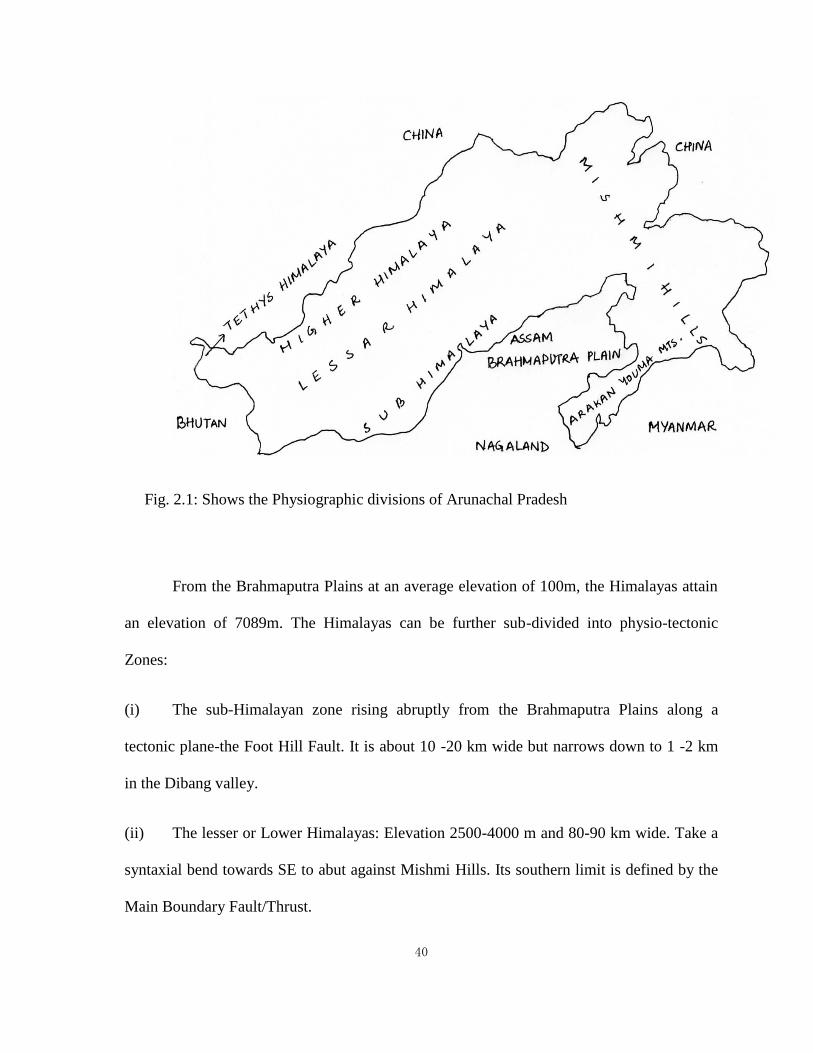
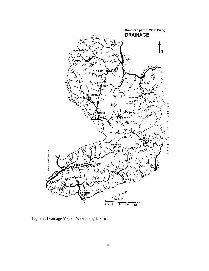
The West Siang district is watered by many rivers and streams. The important rivers
of the district are Siyom (Yomgoo), Sipuu, Hirik, `Hiruu, Huu, Kidii, `Iigoo, Siji, `Sigen etc.
These principal rivers of the district are drained by the westerly flowing Brahmaputra (Fig.
2.2).
2.4. Geology
The mountains of Arunachal Pradesh are of much later origin than the peninsular India
which originally belonged to the Continent known as Gondwana. The Himalayas on the
eastern fringes of which Arunachal is situated were formed gradually due to the rise of the
bed of the ocean called Tethys (Chatterjee 1991).
Geological research in the Arunachal Himalaya can be traced back to the 19th
century during which several reconnaissance investigations were conducted along its
foothills (Yin et al. 2006). The earliest knowledge on the geology of Arunachal Pradesh are
based on notes, not by the geologists, but by the army personnel who made brief references
45
Fig. 2.2: Drainage Map of West Siang District
46
during their punitive expeditions like Lt. Wilcox (1832), Rowllete (1845), Medlicot (1865)
and Pascoe (1911).
However, the foundation of the systematic knowledge about the geology was laid by
workers like Godwin Austen(1875), La Touche (1885), Mclaren (1904), Coggin Brown
(1912), A.M.N Ghosh (1935), Mathur and Evans(1964).
Coggin Brown (1912) took a rapid reconnaissance traverse in Siang valley. Laskar
(1958-59) surveyed a portion of the Siang valley. Near Rengging in search of coal and
limestone deposits Mullick and Basu Chowdhury (1966-67 and 1967-68) carried out
traverse mapping in parts of Siang district including the present area in degree sheets and
brought out the geology of the area in more detail.( Kumar 1997).
Though not much could be done even after independence up to late sixties, because
of its inaccessible terrain, remoteness, hostile climate, dense vegetation and sparsely
distributed human habitants but some significant geological works were undertaken in the
outermost parts of the Akas, Dafla, Miri, Abor, and Mishmi hills.
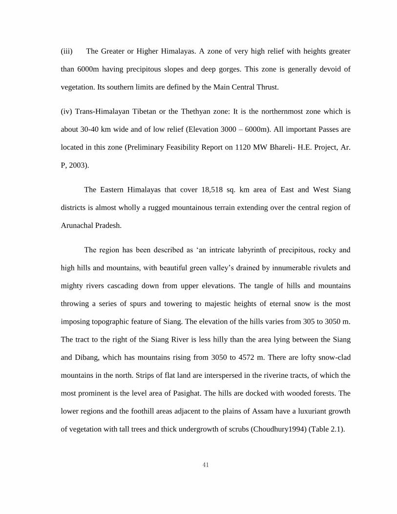
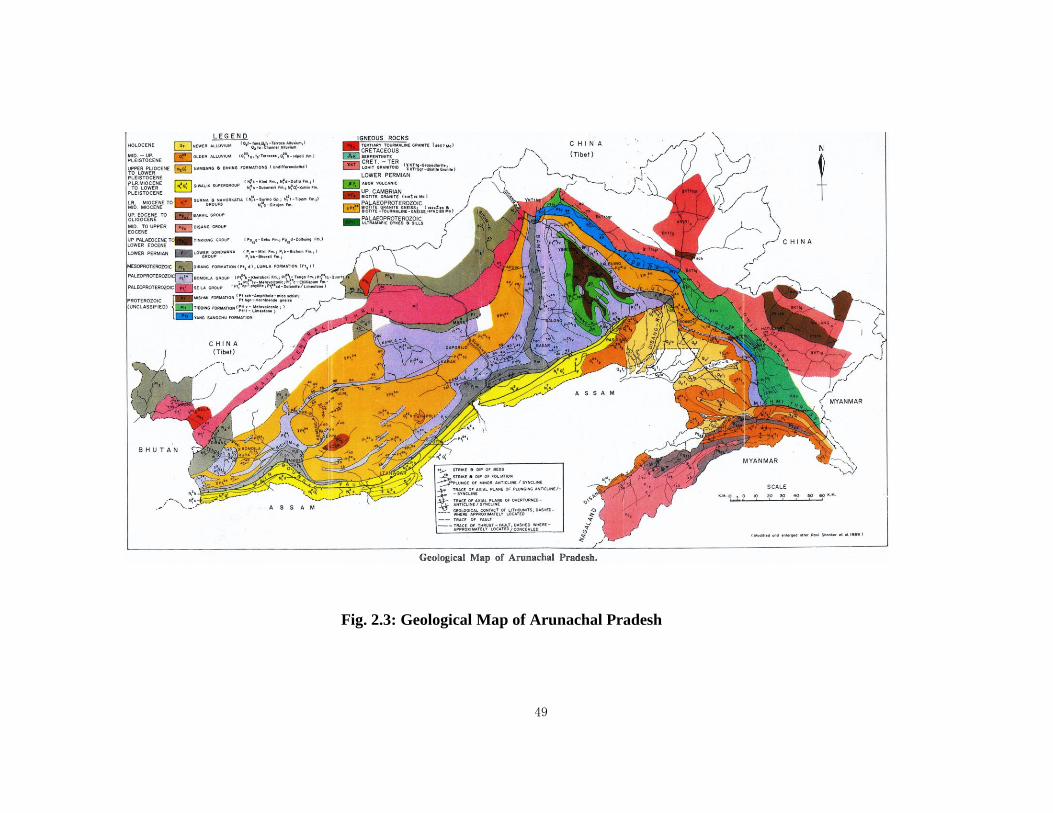
Geologically, Arunachal Pradesh is the least explored state but preliminary studies of
geological formations promise important mineral deposits in considerable quantities. The
geological domain of Arunachal Pradesh is unique and is much different than the other parts
of the Himalaya (Fig. 2.3).
47
2.5. Minerals
The important mineral deposits in the West and East Siang district of Arunachal Pradesh are
sulphide minerals, limestone, coal, graphite, marble, ferrous minerals, clay, kynite etc. The
locally available rocks are sandstone, basalt, gneiss, schist and talcose.
2.6. Climate
Climatically, North- East India falls within the sub-tropical monsoon rain forest belt which
receives the heaviest rainfall in the country. In Arunachal Pradesh the wide altitudinal
difference along with physiography, contributes great climatic variations in the state. It is
hot and humid in the Brahmaputra plain, the Sub-Himalayan and the Naga-Patkoi ranges,
cooler in Lesser Himalaya and Alpine type in Higher and Tethyan Himalayan zones.
The state has variegated climate due to wide altitudinal range. The climate varies
from sub-tropical in the south to temperate and alpine in the north with large areas
experiencing snowfalls during winter. It becomes progressively cold as one move
northwards to higher altitudes.
Along the foothills, bordering the plains of Assam, the climate is humid and hot
while along the international border towards China, the state has high and lofty mountains.
All along the border with China, many of the high mountains are permanently snow capped.
Winter season sets in from October and continuous up to February, followed by summer
season from March to Mid-June. Summer season is hot and humid but is less pronounced
because of the early start of the pre-monsoon rains. The area receives rainfall under the

48
influence of south-west monsoon which generally starts from the month of May to
September/October.
49
Fig. 2.3: Geological Map of Arunachal Pradesh
72
The state receives heavy rainfall of 80 to 160 inches (2,000 to 4,000 mm) annually,
most of it falling between May and September. Winters are severe with thick mist formation
and occasional rainfall. Prolonged period of Monsoon has resulted in luxuriant forest growth
over the hill slopes. The climate throughout the years is damp which results in varieties of
fauna and flora.
As per the Seismic Zoning Map, Arunachal Pradesh has been placed in Zone V
which is susceptible to major earthquakes. Between 1897 and 1984 about 20 major
earthquakes with magnitude greater than 7 (Richter), and 5 with more than 8.0 (Richter)
have been recorded in the area (Kumar 1997).
2.7. Flora
As per State of Forest Report, 1999 of Forest Survey of India, out of total geographical area
of 83,740 sq. kms 68,045 sq.kms which is 81.37% of the total geographical area is under the
forest cover thus making Arunachal Pradesh the largest dense forest cover state in the
country.
The forests of Arunachal Pradesh possess a phenomenal range of biological
diversity, both in flora and fauna. The richness of life forms i.e. the flora and fauna that
occur in these forests has biological diversity with over 5000 plants, about 85 terrestrial
mammals, over 500 birds and a large number of butterflies, insects and reptiles.
The region is endowed with lush green tropical, subtropical, temperate coniferous as
well as broad-leaved forests, sub-alpine scrub and alpine pastures having unique diversity of
plant and animals. The region has very high humidity throughout the year, which supports
73
luxuriant growth of epiphytic plants. The flora of the region has close affinity with that from
Indo- Malayan region and elements from other parts of India and other neighbouring regions
have contributed to richness and diversity. The region is well known for its orchids and
bamboo.
India is one of the leading countries with vast bamboo cover represented by 23
genera and 128 species of which Arunachal Pradesh contributes 15 genera and 50 species.
The different species of bamboo found in the region are Bambusa pallida, B. tulda,
Chimonobambusa callosa, Dendrocalamus hamiltonaii, D. Sikkimensis, Phyllostachys
mannii, Schizostachyum arunachalensis, S. Fuchsianum etc. to name a few. The wide
variety of altitudinal and climatic conditions have given rise to different forest types which
create corresponding natural shelter, food etc. to varieties of wildlife.
The forests of Arunachal Pradesh have been broadly grouped into 5 major types.
These are Tropical Forests, Subtropical Forests, Pine Forests, Temperate Forests and Alpine.
Apart from these forest types there are Degraded Forests, Bamboo Forests and Grasslands
too. Most of the food requirement of the different tribes living in the remote area of
Arunachal Pradesh is met by the different species of plants grown in the forest.
2.8. Fauna
Since the state is widely covered with dense forest, it supports a vast and diverse group of
faunas. The region is home to seven species of primates, Assamese macaque, pig-tailed
macaque, hoolock gibbon, capped langur, rhesus macaque, slow loris and stump-tailed
macaque. The state harbours a rich variety of wildlife which includes 4 major types of cats
such as snow leopard, leopard, tiger and clouded leopard and three goat antelopes- serow,
74
goral and takin. High altitude animals include musk deer, bharal, Himalayan black bear, red
panda and other animals like elephants, gaur, wild buffalo civets, rodents, squirrels,
porcupine and rats, mongoose, linsang, shrew and bat species are also commonly found. The
state animal is Mithun (Bos frontalis) existing both in wild as well as in semi-domesticated
form. This animal has religious significance and intimate relation with socio-cultural life of
the people.
Arunachal Pradesh fauna also comprises of around more than 500 birds species,
many of which are highly endangered like White-winged Duck, Sclater’s Monal, Bengal
Florican, Temminck tragopan, Rufous-necked Hornbill, Yellow-rumped Honeyguide,
Spotted Wren Babbler, Broad-billed Flycatcher, Rufous-breasted Bush Robin, Long-billed
Thrush and the Black-necked Crane etc. This is the richest state for pheasants with some
species found at different altitudes. The great Indian Hornbill is the state bird of Arunachal
Pradesh. Apart from birds, there are numerous species of butterflies, moths, beetles in
Arunachal Pradesh. Arunachal Pradesh is equally rich in reptiles, amphibian and Pisces. The
rivers contain a wealth of fish.
The state is unique in having traditional rights of various tribes over land, water and
forest within their jurisdiction. Each tribe as a community exercises control over the natural
resources within their surrounding habitation. They sustainably use the resources for shelter,
cultivation, food and other day to day multifarious uses. This rich bio-diverse area however
does have threats associated with biodiversity loss. Some of the major causes for
biodiversity loss being deforestation, jhum cultivation, forest fires, unscientific methods of
harvesting and to some degree poaching and hunting of wildlife.
75
T. Bloch (1906-7) who conducted his first archaeological survey of this area during
1906-7, observed that due to the unfavourable conditions of the climate of North-East India,
with its torrential rainfall, perpetual recurrences of seismic disturbances, highly acidic soil
this area is most unsuitable for preservation of ancient relics and monuments. The thick
vegetative cover in this area presents, so as to say, an unfavourable condition for
archaeological investigations.
Though T. Bloch made this observation a century back in which he meticulously
summarized the various reasons which explain the lack of archaeological remains in this part
of the country, his observations hold true even in the present time. Way back in 1972, H.C
Sharma also realized the difficulties regarding archaeological investigation in Northeast
India as it falls under the Tropical Rain Forest Zone.
To understand archaeology of a region the ecological perspectives plays an important
role. There is a strong correlation that exists between people and the physical environment
that they live in for their survival.
This chapter as a whole gives an insight into the topography, flora, fauna, climate,
geological history and minerals of the region to understand the crucial human-environment
relationship; how the environment impacts and shapes a culture. Same physical environment
does not necessarily produce identical cultures as different communities use its own unique
strategies to survive in its given natural setting, therefore, an understanding of the
environmental setting of the Adi-Galo tribe is imperative. The survival strategies of the Adi-
Galos are based on sustainability. Their relationship with the environment is deeply intense
and their livelihood is mostly depended on it.
76
The understanding of the natural environment of this region is paramount for the
study of past social behaviour. The interactions between humans and environment help to
understand spatial variations of culture, its development, and distributions. The inaccessible
topography but the availability of edible wild plants and animals in surplus of the region
provide the present population a unique strategy to survive in its natural setting and this
interaction resulted in a unique individual adaptive strategy for the Adi- Galos.
Chapter 3
Archaeology of Arunachal Pradesh
Despite constant efforts, very little is known about the prehistory of North-East India.
Archaeological exploration in the region is as yet at a reconnaissance stage. Heavy
precipitation, dense vegetation, excess humidity and highly acidic soil have made the work
of archaeologists in the region difficult in archaeological investigation.
Sir John Lubbock (1867) was the first person to find a jade Neolithic implement in
Upper Assam and subsequently there were reports of findings of stone tools from other
77
region also but archaeological study of the region actually started from the mid 20th century.
It was the continuous efforts of archaeologists whose important discoveries brought to light
the important of archaeology in this part of the country.
The important Neolithic site in North-East India are Daojali Hading (Sharma 1967),
Sarutaru (Rao 1973) in Assam, Napachik (Singh 1993) in Manipur, Parsi-Parlo (Ashraf
1990) in Arunachal Pradesh and Garo Hills (IAR 1966-67, 67-68) in Meghalaya.
Garo Hills in Meghalaya has become the focus of interest in the study of prehistoric
archaeology of North-East India after the discovery of a number of palaeolithic sites at
Rongram River Valley.
In Arunachal Pradesh Parsi-Parlo in Kurung Kumey district, is the only Neolithic site
excavated so far. The prehistoric human occupation in the Kamla Valley was first reported
by D.K. Duarah in 1979 when he collected three Neolithic celts. Later in the year 1982-83,
A. A. Ashraf, Assistant Director of Research Department, Arunachal Pradesh carried out an
extensive exploration in nearby villages like Vigo, Lia, Nindung, Pagam, Paleng, Sangram
and Taba which led to the discovery of a neolithic settlement and a number of prehistoric
stone artifacts (Ashraf 1990). Therefore in the succeeding year in 1983-43 a trial trench was
taken by him, which revealed a single culture horizon which he divided into three phases
viz.
Phase I: Aceramic Neolithic Stage
Phase I is characterized by the presence of scrapers and large cutting tools with the
rudiments of pecked and polished ground techniques.
Phase II: Ceramic Neolithic Stage
78
Ceramic Neolithic Stage is the continuation of the preceding phase with conspicuous
absence of scraper and large cutting tools and also the presence of hand-made pottery
(stamped/cord impressed ware). The tools in general provide hafting facilities and are
mostly for agricultural use.
Phase III: Ferrolithic Stage
Ferrolithic Stage is the continuation of the preceding phase but with the emergence of iron
tools. A single piece of iron implements probably a hoe-blade, along with a lump of raw
material has been found. The tools of this phase are round butted pecked and ground celts.
No structural remains were found, open fire-places were encountered. Pottery forms small
part, continued to be same in all respects as that of Phase II.
Ashraf reports that the Neolithic tools found in the region are mainly of 2 types,
celts with lenticular cross sections, hog-backed type and slender chisels of jadeite. The tools
were mostly made in jadeite. He further adds that the archaeological materials recovered
from the site bear similarity with that of the material from South East Asia.
In the absence of horizontal excavation, information regarding the physical layout of
the Neolithic communities is very meagre.
Earlier archaeologists who worked in the region have already established that the
Neolithic of North-East India is a product of the Neolithic of Southeast Asia (Medhi 1993).
According to Worman (1949) the Neolithic tradition of East Asia made its way into India
through North-East India. Archaeologists working in the region have identified the pebble
axes, choppers and pounders found in North-East India as Hoabinhian tool which is
suggestive of link with South-East Asia (Medhi 1993).
79
The Hoabinhian techno-complex has long been considered as a manifestation of the
relative crudity of Southeast Asian stone tool technology. H.L Movius coined the
expression: crude, colourless, and unenterprising” to refer to the stone tool technology of
South east Asia, which he characterized as a chopper-chopping tool complex of large heavy
tools requiring little skill to produce and demonstrating no artistic inclinations. Some
archaeologists tried to counteract the inevitable impression that people who produced such
tools were also probably crude and unenterprising by postulating theories based on
environmental factors. According to such theories, stone did not play a key role in
prehistoric Southeast Asian technology, because bamboo and other organic materials were
available and more efficient (Miksic 1995).
3.1. Material Remains
Generally, the Neolithic tools collected from the state are stray finds, mostly found in
surface collection. The Neolithic Celts have a wide distribution in different regions of
Arunachal Pradesh but without any stratigraphic context and thus throw little light on the
date of the Neolithic culture in this area.
The occurrences of such Neolithic celts and the beliefs associated with them are
widespread all over the world. These are reported from Europe, Russia, North America,
Africa, Japan, Burma, China, Malays and in the Eastern part of India. In Ejura, Ashanti, the
Neolithic celt is called nyame akuma (god-axes), in Malay, batu-lintar, batu-hali lintar or
batu petir (thunder stones) in Burma, mu ningwaa (Mu’s axe heads), in Japan raifu
(thunderbolts) and in Central Italy, fulmini, or folgori. The belief that stone celts are
“thunderbolts” is widespread in the Naga Hills among different Naga tribes like Konyak,
80
Sema, Angami, Ao and Lhota (Hutton and Mills 1872). Some of the Naga tribes regard them
as luck-bringing but the Lhotas on the other hand usually will not touch them (Balfour
1929). Neolithic celts are reported from almost all the states of North-East India.
Throughout the world celt is believed to possess one of the following powers:
These celts are believed to have prophylactic use against illness. The surface of the
celt is scraped and the powder that comes out of the scraping is mixed well with
water. This mixed liquid is then taken by the sick person as a medicine which is
believed to heal the ailed person.
Celt is also looked both as charms objects which bring good luck and as devil’s axe
which brings misfortune.
Though the theory of “thunderbolt” is just a fictitious product of imaginations to the cold
and unemotional eyes of the scientist but the general adherence to the older belief steadily
persisted and such objects continue to be regarded as either freaks of nature or of extra-
telluric provenance. The “thunderbolt” theory still remains dominant (Balflour 1929).
In Arunachal Pradesh neolithic celts are considered as celestial objects fallen from
the sky by the local tribes. There are various ideas about these celts among them; some of
the tribes consider celts as good omen and worships them while for others the celt is
believed to cause misfortune if kept inside the house. So these are discarded immediately at
the sight of it or left untouched. The celts are occasionally found during mountain clearings
because that is when the forest is cleaned to be prepared for cultivation. As pointed earlier,
these celts when encountered are discarded or thrown away into the nearby forest
immediately before the bad effects of the celts start affecting their life.
81
The celt is known by different names among different tribe all over the region (Table
3.1). The Adi-Galos believe that these celts bring bad-luck thus these celts are not brought
home and even encountered in the forest and are discarded.
Ashraf (1998) has classified the types represented in Arunachal Pradesh as
shouldered celt, facetted celt, tanged axe, chisel and celts of more or less triangular and sub-
rectangular shape. Typologically, there are two dominant types, viz., stone axes with
lenticular cross section and faceted quadrangular type with rectangular cross section. The
minor types are hog-backed type of celt slender chisel of jadeite. Technologically, most of
the neoliths, so far collected from Arunachal are chipped and edge ground or fully ground
tools. Jadeite and shale are the most commonly used stone to manufacture these celts.
Ground and polished stone tools represent the neolithic phase of prehistoric culture
in North-East India. These celts were used by men during their pre-metallic cultural phase.
These celts are now artefacts of vanished cultures.
Table 3.1: Shows the different names of celts among different tribes of Arunachal Pradesh
Tribes Local Names of the celt
Aka Jeu- forje (Axe of Jeu deity)
Digaru Bura –tapah (bura-cloud, tapah-thunder)
Galo Mugli Ege
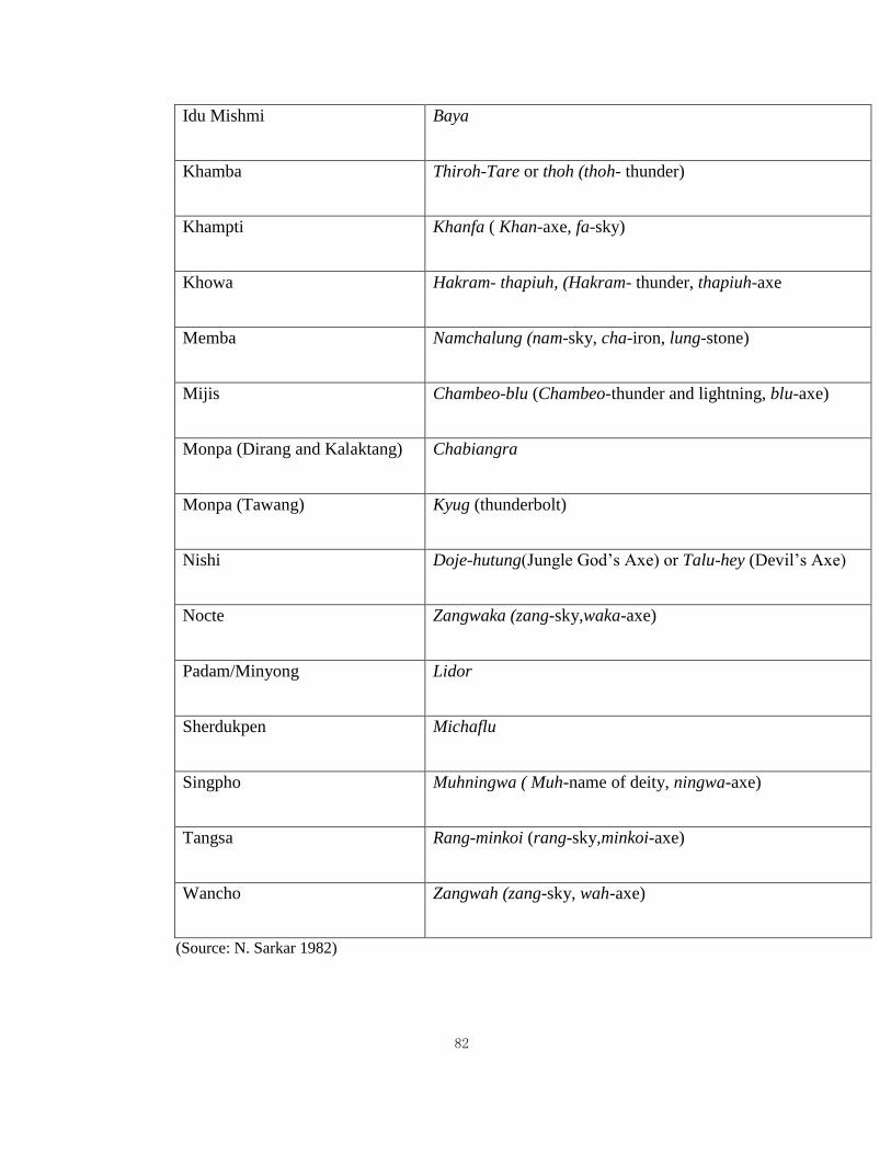
82
Idu Mishmi Baya
Khamba Thiroh-Tare or thoh (thoh- thunder)
Khampti Khanfa ( Khan-axe, fa-sky)
Khowa Hakram- thapiuh, (Hakram- thunder, thapiuh-axe
Memba Namchalung (nam-sky, cha-iron, lung-stone)
Mijis Chambeo-blu (Chambeo-thunder and lightning, blu-axe)
Monpa (Dirang and Kalaktang) Chabiangra
Monpa (Tawang) Kyug (thunderbolt)
Nishi Doje-hutung(Jungle God’s Axe) or Talu-hey (Devil’s Axe)
Nocte Zangwaka (zang-sky,waka-axe)
Padam/Minyong Lidor
Sherdukpen Michaflu
Singpho Muhningwa ( Muh-name of deity, ningwa-axe)
Tangsa Rang-minkoi (rang-sky,minkoi-axe)
Wancho Zangwah (zang-sky, wah-axe)
(Source: N. Sarkar 1982)
83
However, archaeology in itself is not adequate to understand past human cultures in
North-East region. Hence incorporating ethnographical approach is essential and
exceedingly constructive to understand the use and function of celts in this region.
According to E.C Worman (1949) “The neolithic problem in the prehistory of India
pointed out that Assam was the corridor through which celt-making techniques entered
India”. He proposed that the Indian smoothed stone celts of neolithic type, regardless of the
cultural affiliation, appear to be derived from the eastward.”
3.2. Archaeology in West Siang district
Not much is known about the prehistoric archaeology of West Siang district. This was a
further motivation to undertake this research work in this particular area.
The only excavated site in the district is the Malinithan temple complex, a historical
religious site. It is situated at the foothills of West Siang district under the Likabali sub-
division. Malinithan is a place of great sanctity. It is associated with Siva-Parvati. This site
is also associated with Krisna legends. The excavation proved that the ruins are of Hindu
influence. L.N Chakravarty, the former Director of Research, Government of Arunachal
Pradesh places the approximate date of the ruins of Malinithan as of the 13th and 14th
century A.D.
Any conclusive attempt, to identify the temple with any particular dynasty or king
has not been possible yet despite the belief that the temple was constructed during the Pala
period of Assam (Kamarupa) (Dutta 1997) who roughly ruled from 10th to 12th century
A.D.
84
The focus of the present research is on the prehistoric and aboriginal culture hence
no attention was given to the early historical remains and influence from outside. Before any
attempt to start this study it was known to the research scholar that some stone tools have
been collected by the locals in their region. The Adi Galos of villages like Bagra, Jini are
well aware of the existence of stone tools. However, no importance is given to these tools by
the villagers because the celts are considered as Devil’s Axe (Mugli or Yapom Ege) by them.
In fact the Adi-Galos classify any objects with unknown origin as the possession of devil.
Any kind of object not referred in their myth or oral tradition is of an unknown origin to
them.
During the village to village survey there was an attempt to search for archaeological
artefacts through explorations and interactions with the local villagers. No tools were
personally collected during the surveys. The only clear area is the settlement area and the
rest of the area which is not inhabited is thickly forested which is one of the deterrent factor
in finding any tool. However, during the interviews villagers narrated coming across those
tools but of course thrown far away as these are considered as a sign of bad omen.
Fortunately, two villagers had kept the tools which they found. On request they brought the
tools and agreed to lend it for documentation and also provided important information about
the context from where the tools were collected.
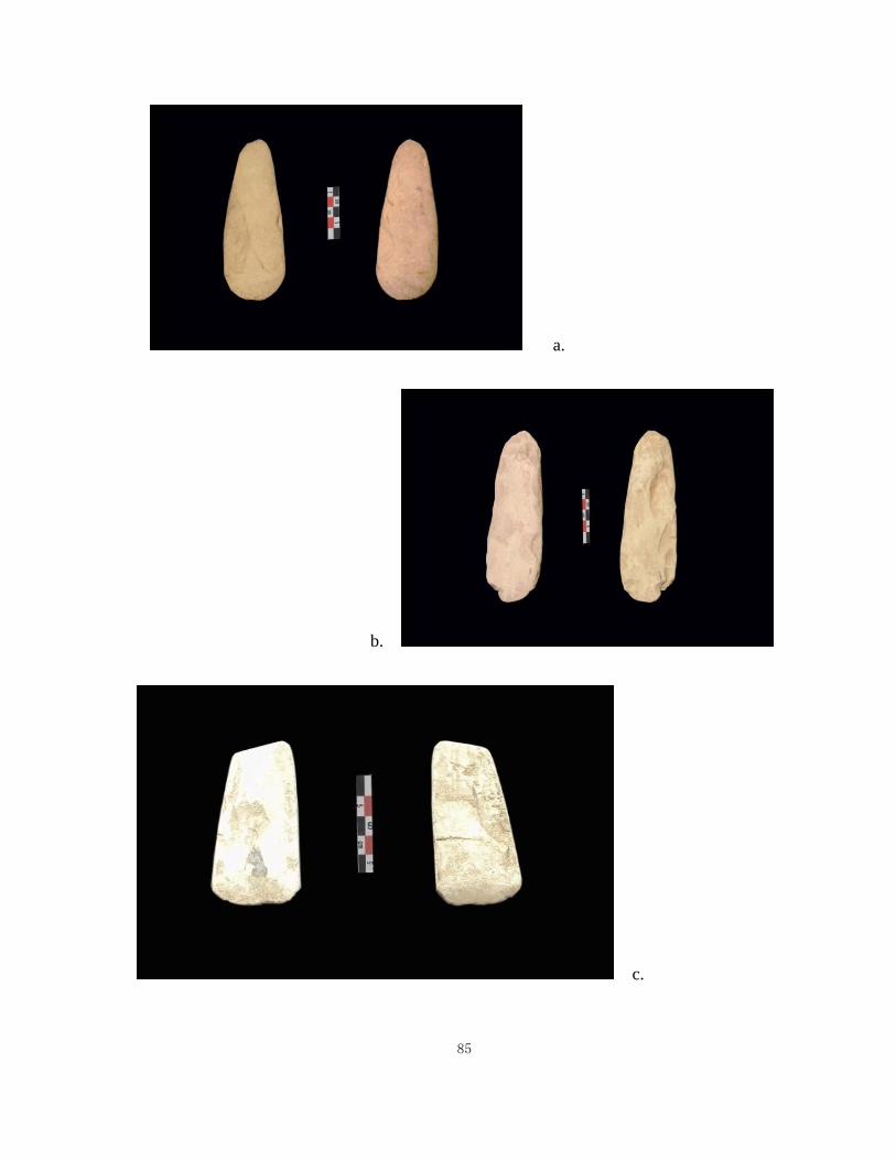
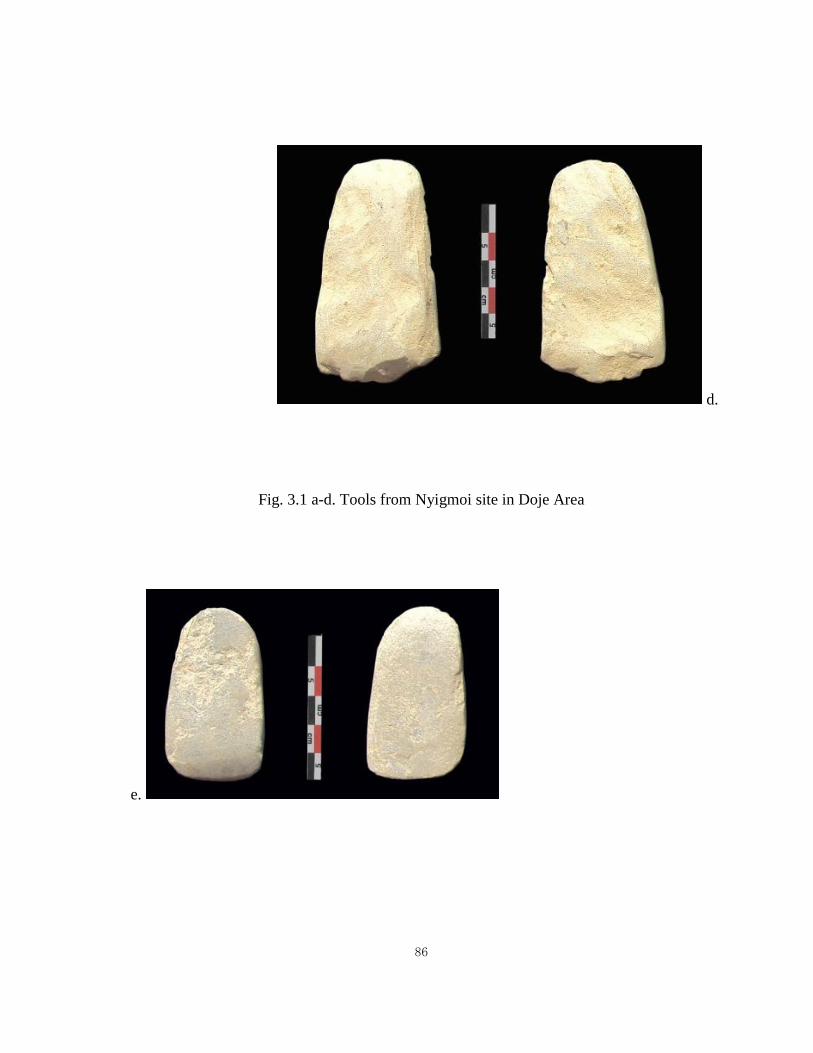
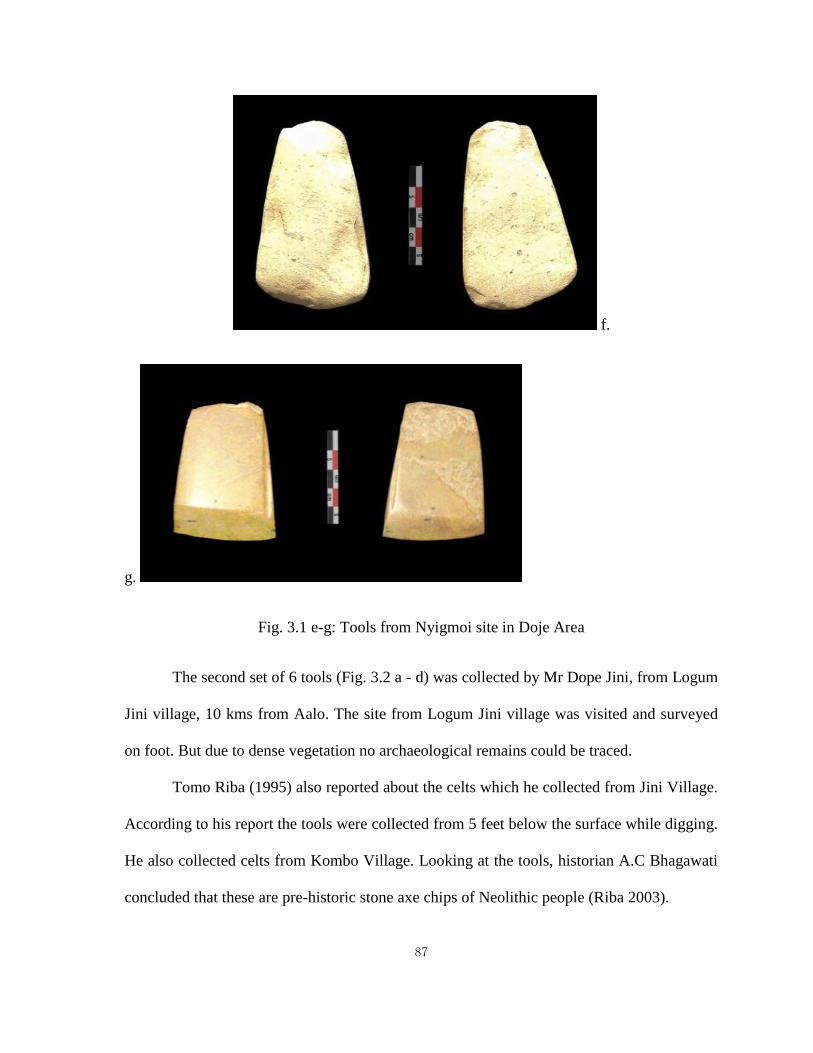
A total of 15 tools were found. The first set of 9 tools (Fig. 3.1 a - g) was collected
by Gumtum Ete from Nyigmoi site in Doje which is 28 Kms away from the West Siang
district headquarter, Aalo. The tools were collected while ploughing the field in 1995-96.
85
a.
b.
c.
86
d.
Fig. 3.1 a-d. Tools from Nyigmoi site in Doje Area
e.
87
f.
g.
Fig. 3.1 e-g: Tools from Nyigmoi site in Doje Area
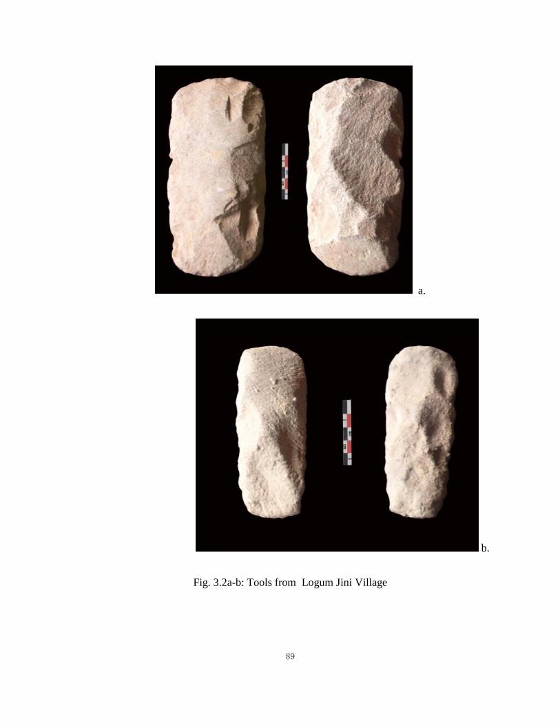
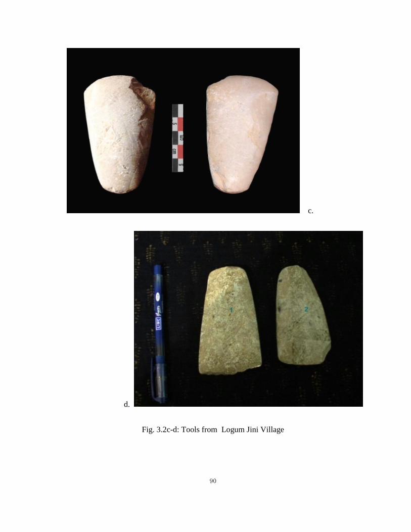
The second set of 6 tools (Fig. 3.2 a - d) was collected by Mr Dope Jini, from Logum
Jini village, 10 kms from Aalo. The site from Logum Jini village was visited and surveyed
on foot. But due to dense vegetation no archaeological remains could be traced.
Tomo Riba (1995) also reported about the celts which he collected from Jini Village.
According to his report the tools were collected from 5 feet below the surface while digging.
He also collected celts from Kombo Village. Looking at the tools, historian A.C Bhagawati
concluded that these are pre-historic stone axe chips of Neolithic people (Riba 2003).
88
In both these Galo villages, celts are called Mugli ege (thunderbolt) or Yapom Ege
(devil’s axe) and considered as a sign of bad omen. The locals of these two villages have no
memory of the functional use of these stole tools. Even in their oral tradition there is no
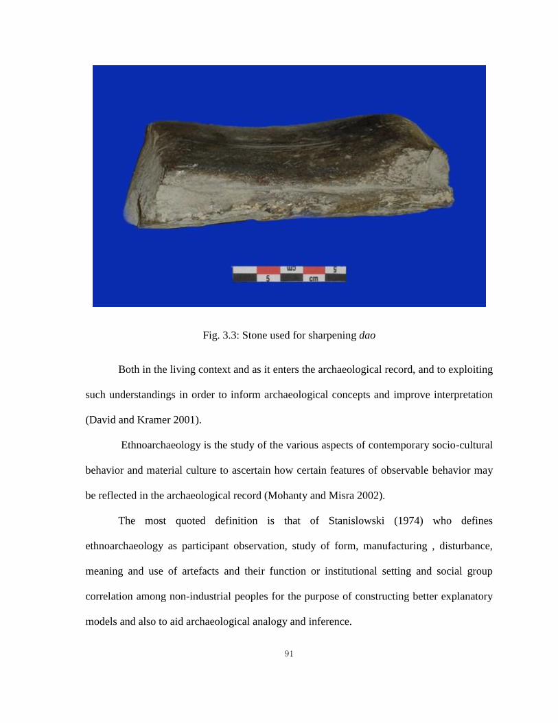
mention of the use of stone as tool. In their living memory stone was only used as sharpener
to sharpen dao (Fig.3.3) and therefore no direct association is found between the local
inhabitants and the stone tools found from the region. Stone celt is seen as an object of the
devil. Thus in the light of the evidence it can be said that the Adi-Galos did not use stone
tools but the stones tools found in the region may belong to the earlier group of people who
occupied that region before them. However, more evidence is needed to reinforce this
hypothesis.
3.3. Ethnoarchaeology
Ethnoarchaeology has emerged in recent decades as an important tool for the
interpretation of archaeological data. Ethno-archaeology is the ethnographic study of living
cultures from archaeological perspectives. It is a research strategy embodying a range of
approaches to understanding the relationships of material culture to culture as a whole.
89
a.
b.
Fig. 3.2a-b: Tools from Logum Jini Village
90
c.
d.
Fig. 3.2c-d: Tools from Logum Jini Village
91
Fig. 3.3: Stone used for sharpening dao
Both in the living context and as it enters the archaeological record, and to exploiting
such understandings in order to inform archaeological concepts and improve interpretation
(David and Kramer 2001).
Ethnoarchaeology is the study of the various aspects of contemporary socio-cultural
behavior and material culture to ascertain how certain features of observable behavior may
be reflected in the archaeological record (Mohanty and Misra 2002).
The most quoted definition is that of Stanislowski (1974) who defines
ethnoarchaeology as participant observation, study of form, manufacturing , disturbance,
meaning and use of artefacts and their function or institutional setting and social group
correlation among non-industrial peoples for the purpose of constructing better explanatory
models and also to aid archaeological analogy and inference.
92
Ethnoarchaeology has been variously termed as “action archaeology” (Kleindienst
and Watson 1956), “Living Archaeology” (Gould 1968, 1974), “archaeoethnography”
(Oswalt 1974) and ethnographic archaeology (Pastron 1974).
Since 1960’s, the field of ethnoarchaeology has emerged as a discipline explicitly
concerned with examining the archaeological relevance of contemporary phenomena,
including such topics as site formation and depositional processes; documentation of
traditional technologies, community forms, and settlement patterns, the relations between
humans and their environment; and the study of the material implications of a variety of
social systems and social strategies as well as ideologies and belief systems (Sinopoli 1991).
In her article, “Seeking the Past through the Present, Recent Ethno-archaeological
Research in South Asia” Carla A. Sinopoli has taken a very broad definition of the field and
included not only explicitly ethnoarchaeological studies but also ethnographic studies that
have focused on material culture without necessarily being concerned with their
archaeological implications. According to her, ethnoarchaeological study has also served as
a warning, alerting us to the complexity of human behaviour and the tremendous diversity
and creativity manifest in human manipulation of the material world (Sinopoli 1991).
The strength of ethnoarchaeology lies in the fact that it involves “actualistic studies”
of the practices of everyday life through which observations are made. Ethnoarchaeology
can provide some valuable information since it involves the study of material culture in
context, the study of an actual situation as opposed to a fabrication or simulation (Schiffer
1978).
Ethnoarchaeological studies can be directed at settlement patterns, artefacts
distribution, pottery-making and hunting practices.
93
Majority of ethno-archaeological reports and projects of South East Asia are on
hunter- gatherers and ceramics. Ethnoarchaeological research work in Southeast Asia is
affected by certain difficulties, there is hardly any work done in the field of environmental
analysis.
There is very little data regarding the long term adaptation of humans to the many
habitats which the region affords. There is no adequate means of testing the hypothesis that
much of Southeast Asia’s vaunted cultural diversity is linked to the special environment
factors which characterize the region (Miksic 1995).
3.3.1 Ethnoarchaeology in Arunachal Pradesh
The dimensions of ethnoarchaeology in North-East India can, in fact, be diverse. In this
thesis an attempt has been made to use ethnoarchaeology as a tool to refine our explanations
for the interpretation of past human behaviour in the region under study.
This view is strongly supported by Gould and Watson (1982), who clearly remarked that
“Ethnoarchaeology, formally or informally applied, is the source of all observations that
enable archaeological interpretation” (Agorsah 1990).
In North-East India, most of the ethno-archaeological work conducted so far has
mainly been done on megalithic culture and ceramics; Sharma (2011), Kaping (1998),
Medhi (1983) etc.
Though, it has to be noted that ethnoarchaeology of the aborigines in North-East
India is centered around ethnographic data due to the high use of locally available perishable
94
materials and poor preservation of any kind of remains. This fact will be clearly
demonstrated in the present work.
Ethnographic data has been gathered which has proved to be of immense help to
reconstruct the extinct cultures which are poorly preserved in the archaeological record and
also in understanding the process of cultural development in the area. Data gathered from
observing living peoples can help shape ideas about process, variability in form and
function, and specific interrelationships between non-tangible aspects of culture and their
material counterparts (Hayter 1994).
Ethnographic data can also help to understand many complex issues related to the
past of this region. The archaeological record consists of the material traces of behaviour
and not the behaviour itself so ethnographic data is used in archaeology to fill these
behavioural voids in the record. Ethnographic data is further used to document what cannot
be recovered as archaeological records that are perishable material.
A.A. Ashraf (1998) remarked that the archaeological problem of this region may be
better understood if the existing ethnographic conditions are studied. He carried out
ethnoarchaeological research work among the Nishi tribe of Kamla Valley, Kurung Kumey
district to understand their traditional subsistence technique and prehistoric technological
strategy.
The present work is an attempt to contribute in the ethnoarchaeological research of
Arunachal Pradesh. Nevertheless, it is to be noted that ethnography is the main tool for not
only understanding the present communities of the region but also the past. Thus,
ethnographic approach has been the principle method for the present research.