chapter 2 goals, management intent, and guidelines
TRANSCRIPT

Chapter 2 Goals, Management Intent, and Guidelines Introduction ............................................................................................................................... 1
Definitions........................................................................................................................... 1 Goals ................................................................................................................................... 1 Management Intent ............................................................................................................. 2 General Framework of the Plan .......................................................................................... 2 Guidelines by Activity or Resource Value ......................................................................... 3 General ................................................................................................................................ 3 Other State Land ................................................................................................................. 4
Aquatic Farming ....................................................................................................................... 5 Management Guidelines ..................................................................................................... 6
Coordination and Public Notice ................................................................................................ 8 Management Guidelines ..................................................................................................... 8
Fish and Wildlife Habitat and Harvest Areas ........................................................................... 9 Management Guidelines: Habitat Areas ............................................................................ 9 Management Guidelines: Harvest Areas ......................................................................... 16 Management Guidelines: Special Management Areas – Tidelands &
Submerged Lands; Other ............................................................................................... 18 Floating Facilities.................................................................................................................... 20
Management Guidelines ................................................................................................... 21 Forestry ................................................................................................................................... 24
Management Guidelines ................................................................................................... 24 Heritage Resources ................................................................................................................. 28
Management Guidelines ................................................................................................... 29 Figure 2.1: Historical and Archeological Sites .......................................................... 31
Instream Flow ......................................................................................................................... 32 Management Guidelines ................................................................................................... 32
Materials Resources ................................................................................................................ 33 Management Guidelines ................................................................................................... 33
Mineral Resources .................................................................................................................. 35 Management Guidelines ................................................................................................... 37
Table 2.1: Mineral Closing, Opening, and Leasehold Location Orders .................... 38 Figure 2.2: Mineral Closure Orders, Leasehold Location Orders, and
Mineral Opening Orders .......................................................................................... 40 Figure 2.3: Mineral Resources: Deposits, Prospects, and Occurrences .................... 41
Oil and Gas ............................................................................................................................. 42 Management Guidelines ................................................................................................... 43
Figure 2.4: Oil & Gas and Coal Basins...................................................................... 44 Public Access Easements, Neighborhood Trails, and Public Access .................................... 45
Management Guidelines: Public Access – General ......................................................... 45 Management Guidelines: Access Corridors..................................................................... 45 Management Guidelines: Public Access .......................................................................... 47

Recreation, Tourism, and Scenic Resources ........................................................................... 50 Management Guidelines ................................................................................................... 51
Table 2.2: Nushagak & Mulchatna Rivers Recreational Management Guidelines (same as Table 3.1 in the RRMP) ............................................................................ 56
Settlement ............................................................................................................................... 58 Management Guidelines ................................................................................................... 61
Shorelines, Stream Corridors and Coastal Areas .................................................................... 67 Management Guidelines ................................................................................................... 67
Table 2.3: Application Requirements for Easements and Buffers Along Waterbodies and Related Environmental Features ....................................................................... 72
Transportation ......................................................................................................................... 74 Management Guidelines ................................................................................................... 75
Figure 2.5: Transportation Corridors ......................................................................... 78

Chapter 2 - Goals, Management Intent, and Guidelines
Bristol Bay Area Plan September 2013 2 - 1
Chapter 2 Goals, Management Intent, and Guidelines
Introduction This chapter presents land management policies for each of the major resources affected by the plan: fish and wildlife; forestry; materials; mineral resources; recreation and tourism; and water. The chapter also presents management policies for several specific land management concerns: protection of fish and wildlife habitat; public and private access; settlement; shoreline and stream corridors; trail management; public recreation and tourism; oil and gas; etc. In addition, this chapter addresses types of land uses including: aquatic farming; forestry; fish and wildlife harvest; floating facilities; settlement; transportation and trails management; and shoreline use and waterfront development. Note: This chapter was partly revised in 2013 in order to incorporate those revisions associated with the 2013 plan amendment and to reflect changes in organizational structure and/or statute that were changed subsequent to the approval of the 2005 BBAP. These policies apply to state land throughout the planning area regardless of the land use designation. This chapter consists of goals and management guidelines. Goals are the general condition the department is trying to achieve, and guidelines are specific directives that will be applied to land and water management decisions as resource use and development occurs. Definitions For definitions of terms commonly used in this chapter and others, please see Appendix A, Glossary. Goals The following are goals for state lands in the planning area. Goals are general conditions that DNR attempts to achieve through management actions. The goals are listed alphabetically. No single goal has a priority over the others. Economic Development. Provide opportunities for jobs and income by managing state land and resources to support a vital, self-sustaining local economy.

Chapter 2 - Introduction
2 - 2 September 2013 Bristol Bay Area Plan
Fiscal Costs. Minimize the needs for, and the fiscal cost of, providing government services and facilities such as schools and roads. Public Health and Safety. Maintain or enhance public health and safety for users of state lands and resources. Public Use. Provide and enhance diverse opportunities for public use of state lands, including uses such as hunting, fishing, boating, and other types of recreation. Quality of Life. Maintain or enhance the quality of the natural environment including air, land and water, and fish and wildlife habitat and harvest opportunities; protect heritage resources and the character and lifestyle of the community. Settlement. Provide opportunities for private ownership and leasing of land currently owned by the state. Sustained Yield. Maintain the long-term productivity and quality of renewable resources including fish and wildlife, and timber. Management Intent Management intent for state land is expressed through statements of management emphasis identified on a management unit specific basis. These statements are based on resource and use inventory, existing and potential trends, existing authorizations, existing plans, and public participation. General Framework of the Plan A. State land within the planning area will be managed to allow for multiple use unless legislatively designated or a management unit of state land is less than 640 acres and managed under a management agreement by another state agency. It is the intent of the plan to provide land use designations for all state-owned and state-selected lands in the planning area. Any lands inadvertently missed or any state lands, lacking a land use designation, situated in gaps between this plan and adjoining plans are designated using the guidelines in Chapter 4 under ‘Applicability of Plan Designations/Classifications to State Lands not Identified in the Plan Text or Plan Maps’. B. State land will also be managed to protect access and public resources. Types of resources to be protected include, but are not limited to habitat, recreation, water quality, anchorages, watersheds, scenery, and trails.

Chapter 2 - Introduction
Bristol Bay Area Plan September 2013 2 - 3
C. State land will remain open to mineral entry unless specifically closed. This plan does not recommend any new areas be closed to mineral entry nor to be managed under a leasehold location order. Consequently, all land within the planning area is open to entry, except for those areas closed in previous mineral closing orders by DNR. D. In management units where a primary use has been designated, activities and authorizations pertaining to that primary designated use may take precedence over other uses. Although there may be a priority for use in certain management units, other uses may also be allowed if they do not foreclose the area for its priority use. This plan emphasizes minimizing land use conflicts through plan guidelines and management intent rather than through prohibitions. All other uses are initially presumed compatible with the primary use. However, if DNR determines that a use conflict exists and that the proposed use is incompatible with the primary use, the proposed use shall not be authorized or it shall be modified so that the incompatibility no longer exists (11 AAC 55.040 (c)). E. This plan designates state lands in categories that are generally consistent with current use patterns and the most significant resource values in the planning area. F. This plan honors the intent of existing settlement agreements with the Mental Health Trust Authority and the University of Alaska. These settlement agreements shall prevail over the area plan if inconsistencies exist. Guidelines by Activity or Resource Value The following guidelines are specific directives that will be applied to management decisions. DNR will use these guidelines when considering issuing authorizations and conveyances or making management decisions on state lands. These guidelines will also apply to lands that are currently state selected and ANILCA filed when they are tentatively approved or patented into state ownership. Chapter 2 guidelines apply to all state land covered by the Bristol Bay Area Plan unless the plan explicitly exempts some management units or designations from a guideline or the resource or use for which a guideline is intended does not exist in the unit in question. General A. All authorizations for use of state land within the planning area will be consistent with the management intent in this plan. B. In considering authorizations for use of state land, DNR will adjudicate applications to:
1. minimize damages to streambeds, fish and wildlife habitat, vegetation, trails, anchorages, and other resources;

Chapter 2 - Introduction
2 - 4 September 2013 Bristol Bay Area Plan
2. minimize conflicts between resources and uses; and 3. protect the long-term value of the resource, public safety, and the environment.
C. If authorizations from other agencies are required, DNR will consider issuing a permit or lease contingent upon issuance of these other authorizations. Other State Land Management units that are donated or acquired after the plan is adopted will be designated for the uses for which they were acquired or donated without an amendment to the plan. Lands that come into state ownership through other means will be classified Resource Management Land, or another land use classification following consultation with other state resources departments, without an amendment to the plan.

Chapter 2 - Aquatic Farming
Bristol Bay Area Plan September 2013 2 - 5
Aquatic Farming Background Currently, there are no aquatic farms within the planning area. However, experimentation is being conducted and as market conditions, technology, and the economics of this industry change, aquatic farms can be expected in the planning area during the next twenty years. Management guidelines for their siting and operation follow. Goal Economic Opportunities and Community Development. Provide opportunities to increase income and diversify the state’s economy through the use of state tidelands and submerged lands for aquatic farming. General Conditions. Alaska Statute (AS 38.05.083) provides that state tidelands and submerged lands may be used, under lease, for aquatic farming or related hatchery operations. It also mandates regulations that: 1) require the Department to establish application siting guidelines; 2) specify the criteria for the approval or denial of lease applications; 3) consider limiting the number of sites to be leased within an area in order to reduce cumulative impacts on the environment and natural resources; and 4) protect the public’s right of access and use of navigable waters and the land beneath them for navigation, commerce, fishing, and other purposes, as required under the Public Trust Doctrine. DNR is required to provide siting guidelines for potential farmers during the application process. The siting guidelines include state regulatory agencies’ requirements and federal laws that provide for the protection of fish and wildlife. Other guidelines are provided that assist in selecting sites that may enhance production or operations, such as areas with good water circulation that provide for abundant food sources and adequate flushing to remove wastes generated from the species being cultured. The state regulatory agencies involved in authorizing farmsites include DNR, the Alaska Department of Fish and Game, and the Alaska Department of Environmental Conservation. If the applicant follows these guidelines, their chances of obtaining the necessary authorizations are greatly improved. State and Federal Review Processes. Regulations at 11 AAC 63 require the Department to make a best interest finding before issuing a lease. The proposed operation must be in the overall best interest of the state before an authorization may be issued. Factors that are to be considered in this decision are identified in 11 AAC 63.050 (b). These factors include: whether the proposed aquatic farm will conflict with other uses; whether it is compatible with land management policies in adopted federal, state, and local plans at the proposed location and nearby uplands; how public access, including the adjacent upland owner’s right of reasonable access, and the public’s rights under the Public Trust Doctrine will be protected;

Chapter 2 - Aquatic Farming
2 - 6 September 2013 Bristol Bay Area Plan
and whether the proposed aquatic farm will have any significant social, economic, and environmental effects. The Preliminary Best Interest Finding is subject to a public and agency review under AS 38.05.945. This review includes localities/boroughs/communities, Native organizations, Fish and Game Advisory committees, adjacent upland owners, and affected valid third party interests. Concurrent with this review is a review under the Alaska Coastal Management Program (ACMP).1 All aquatic farm proposals must be consistent with ACMP statewide standards and the enforceable policies of local coastal district plans, if applicable, in order to be authorized. Federal authorizations that have previously undergone a coastal consistency review may also be required in aquatic farming operations and include the U.S. Army Corps of Engineers’ General Permit 91-7N for aquatic farm structures within navigable waters and Nationwide Permit (NWP 4) which pertains to fish and wildlife harvesting, enhancement, and attraction devices and activities. Aquatic farm proposals that do not meet the requirements of these permits must undergo a separate individual review and authorization process conducted by the U.S. Corps of Engineers. As stated previously, all aquatic farm requests must meet the requirements of 11 AAC 63.050 and the current joint-agency application guidelines provided by DNR. State Authorizations for Aquatic Farms. Should the aquatic farm proposal be found to be in the state’s best interest, an Aquatic Farm Lease will be approved by the Department. The lease specifies operation, siting, environmental and habitat criteria that must be satisfied during the lease term. An Aquatic Farm Operation Permit must also be acquired from the Alaska Department of Fish and Game (ADF&G) in order to ensure that the proposal is technically and operationally feasible, the physical and biological suitability of the area can support the operation, and habitat and public uses of fish and wildlife are protected (AS 16.40.105). ADF&G also requires a transport and acquisition permit in order to obtain and transport seed and/or broodstock between a hatchery and the farmsite and to be able to sell their product. In addition, the Alaska Department of Environmental Conservation (ADEC) requires that the water quality in the growing area meet both the state water quality standards and the requirements of the National Shellfish Sanitation Program, incorporated by reference in 18 AAC 34.200, to ensure the product is safe for human consumption. Product may only be sold from within areas classified by ADEC. Management Guidelines The combination of state and federal review and authorization requirements provides a comprehensive basis for the approval of proposed aquatic farm operations. Additional operational, siting, habitat, or environmental requirements in this plan are therefore generally unnecessary in order to effectively manage aquatic farming operations within the planning area. The subsequent management guidelines delineate standards for the approval of aquatic
1 The Alaska Coastal Management Program was terminated on July 1, 2011, pursuant to AS 44.66.030.

Chapter 2 - Aquatic Farming
Bristol Bay Area Plan September 2013 2 - 7
farm operations and the factors that are to be considered in the siting of these operations next to sensitive uses and resources, and adjacent to federal or state land managed its scenic, recreation, wildlife, or other natural values. A. General Management Approach. Aquatic farming will be allowed on state tidelands or submerged lands unless there is significant conflict with other uses of the immediate area or it is inconsistent with the requirements of 11 AAC 63.050 or this management plan. The siting of aquatic farming facilities may be more difficult on tidelands designated for: log transfer or storage; mineral transfer or access; critical or crucial fish and wildlife habitat or harvest; anchorages; or developed recreation. In addition, siting of aquatic farm facilities may be more difficult on tidelands adjacent to proposed land sales or existing residential areas, legislatively designated areas such as state critical habitat areas or game refuges/sanctuaries, and federal conservation system units such as national parks, monuments, preserves, or wildlife refuges where the upland management objective is to retain a natural environment. Specific stipulations related to siting, operations, and maintenance may be imposed by the Department in addition to those otherwise required in order to achieve site and use compatibility. B. Tidelands Adjacent to State Legislatively Designated Areas or Federal Conservation System Units. The Department will consider adjacent upland resource management goals and objectives when granting authorizations on tidelands and submerged lands adjacent to management units subject to state legislatively designated areas or federal conservation units. When an aquatic farm request is received, the Department will review applicable state or federal management plans for compatibility. Aquatic farming operations that are not compatible with the management intent for uplands set forth in these plans and cannot be made compatible through mitigation measures will usually not be authorized. If however, there is an overriding state interest, there is no feasible or prudent alternative site, and all the other conditions of the local, state and federal permits or authorities are met, then an aquatic farming operation can be authorized. Generally, aquatic farming operations involving the presence of caretaker facilities, structures used for storage or other operational needs, or the presence of personnel on a frequent basis are incompatible adjacent to uplands where the management intent is to retain land in an undeveloped state. The Department will consult the appropriate upland agency when determining compatibility of aquatic farm activities in these areas. C. Other Guidelines Affecting Aquatic Farming. Other guidelines will affect aquatic farming management practices. See other sections of this chapter.

Chapter 2 - Coordination and Public Notice
2 - 8 September 2013 Bristol Bay Area Plan
Coordination and Public Notice Goals Coordination with Other Landowners. Coordinate the use of state land with that of private and other public landowners to provide for the optimal use, development, and protection of area resources. Public Participation. Provide local governments, state and federal agencies, adjacent landowners, and the general public with meaningful opportunities to participate in the process of making significant land use decisions. Management Guidelines A. Notice for Decisions Requiring Public Notice (Under AS 38.05.945). As required by statute, public notice will be given for decisions involving the sale, lease, or disposal of (or interests in) land, property, or resources. Actions not involving a disposal of interest will require public notice in accordance with Division of Mining, Land and Water (DMLW) procedures. Notice will be given to parties known or likely to be affected by an action proposed by the state or an applicant to the state, including upland property owners of adjoining state tidelands or submerged lands. B. Coordination with Local Planning. The enforceable policies of district coastal management plans as well as the comprehensive plans and zoning map/ordinances of communities should be reviewed by DNR prior to issuing permits, leases, or other forms of use authorizations. See http://www.alaskacoast.state.ak.us/ 2 for information on the enforceable policies of district coastal management plans. C. Avoiding Conflicts with Adjacent Upland Owners. Before DNR issues a land use authorization on tidelands, submerged lands, or shorelands, DNR will require applicants to use areas that will reduce the likelihood of possible land use disagreements with upland owners. DNR will consider comments from private landowners and others before making a decision. DNR will retain the right to issue a land use authorization over the objection of adjacent landowners. D. Other Guidelines Affecting Coordination or Public Notice. Several other guidelines may affect coordination or public notice. See other sections of this chapter.
2 The Alaska Coastal Management Program was terminated on July 1, 2011, pursuant to AS 44.66.030.

Chapter 2 - Fish and Wildlife Habitat and Harvest Areas
Bristol Bay Area Plan September 2013 2 - 9
Fish and Wildlife Habitat and Harvest Areas Goals Ensure Access to Public Lands and Waters. Ensure access to public lands and waters to promote or enhance the responsible public use and enjoyment of fish and wildlife resources. Mitigate Habitat Loss. When resource development projects occur, avoid or minimize reduction in the quality and quantity of fish and wildlife habitat. Contribute to Economic Diversity. Contribute to Alaska’s economy by protecting the fish and wildlife resources that contribute directly or indirectly to local, regional, and state economies through commercial, subsistence, sport, and non-consumptive uses. Maintain and Protect Publicly Owned Habitat Base. Maintain in public ownership and protect habitat for fish and wildlife resources. The aim is to supply sufficient numbers and a diversity of species to support commercial, recreational, or traditional uses on an optimum sustained yield basis, or protect a unique or rare assemblage of a species of regional, state, or national significance. Management Guidelines: Habitat Areas A. Mitigation. When issuing permits and leases or otherwise authorizing the use or development of state lands, DNR will recognize the requirements of the activity or development and the effects to habitat when determining stipulations or measures needed to protect fish, wildlife, or their habitats. The costs of mitigation relative to the benefits to be gained will be considered in the implementation of this policy. The underlying integrity of the ecological system and traditional way of life in this region is to be maintained to the maximum extent practicable. All land use activities will be conducted with appropriate planning and implementation to avoid or minimize adverse effects on fish, wildlife, or their habitats. The Department will enforce stipulations and measures, and will require the responsible party to remedy any significant damage to fish, wildlife, or their habitats that may occur as a direct result of the party’s failure to comply with applicable law, regulations, or the conditions of the permit or lease. When determining appropriate stipulations and measures, the department will apply, in order of priority, the following steps. Mitigation requirements listed in other guidelines in this plan will also follow these steps:

Chapter 2 - Fish and Wildlife Habitat and Harvest Areas
2 - 10 September 2013 Bristol Bay Area Plan
1. Avoid anticipated, significant adverse effects on fish, wildlife, or their habitats through siting, timing, or other management options.
2. When significant adverse effects cannot be avoided by design, siting, timing, or other management options, the adverse effect of the use or development will be minimized.
3. If significant loss of fish or wildlife habitat occurs, the loss will be rectified by repairing, rehabilitating, or restoring the affected area to a useful state.
4. DNR will consider requiring replacement or enhancement of fish and wildlife habitat when steps 1 through 3 cannot avoid substantial and irreversible loss of habitat. The ADF&G will identify the species affected, the need for replacement or enhancement, and the suggested method for addressing the impact. Replacement with or enhancement of similar habitats of the affected species in the same region is preferable. DNR will consider only those replacement and enhancement techniques that have either been proven to be, or are likely to be, effective and that will result in a benefit to the species impacted by the development. Replacement or enhancement will only be required by DNR if it is determined to be in the best interest of the state either through the AS 38.05.035 (e) or permit review process.
B. Allowing Uses in Fish and Wildlife Habitats (Ha). These habitats are defined as Areas that serve as a concentrated use area for fish and wildlife species during a sensitive life history stage where alteration of the habitat and/or human disturbance could result in a permanent loss of a population or sustained yield of the species. Fish and wildlife categories used to identify “Ha” (Habitat) designations in this plan include the following:
• Anadromous fish spawning and rearing areas in fresh water or brackish intertidal zones
• Estuaries important for rearing or schooling of anadromous fish • Kelp beds covering large areas that are important marine nurseries • Pacific herring spawning and rearing concentrations areas • Eel grass beds that are important marine nurseries • Waterfowl and/or shorebird concentration areas
• Seabird breeding habitat within each colony area of 500 birds and a two-mile radius around major breeding colonies (more than 20,000 birds)
• Bald eagle nest sites or nest site areas, and known concentrations • Sea lion haulouts and rookeries • Harbor seal haulouts and rookeries • Walrus haulouts and rookeries • Sea otter pupping areas • Bear concentration areas (including concentrations by season)

Chapter 2 - Fish and Wildlife Habitat and Harvest Areas
Bristol Bay Area Plan September 2013 2 - 11
• Important wildlife migration corridors, including nearshore migration routes
• Caribou and moose rutting, wintering and calving concentration areas. The areas designated Habitat (Ha) in Chapter 3 of the plan were defined using the best available information when the plan was written. Most of the areas designated “Ha” are tidelands, shorelands, and submerged land areas; few upland management units were given this designation. It should be noted that many of the large, interior upland management units contain areas of sensitive habitat but were not assigned a Habitat designation. Instead, these large management units were assigned the designation of General Use, reflecting the large size, lack of dominance of any one resource, or absence of known or anticipated development. In these instances, information about the sensitive resource(s) as well as management intent language has been provided. The management intent indicates the kind and level of protection to be afforded the resource(s). It should be emphasized that the use of the Habitat designation does not preclude compatible human uses. In the designation of habitat areas on tidelands, data sources were sometimes of a generalized nature. Because of this and in order to be conservative in the delineation of habitat areas, large tideland areas were identified. The wildlife and fishery information identified for specific management units in Chapter 3 occupy either part or all of the area of a management unit. The resource that was used to determine that an area should be designated “Ha” is identified in the management unit descriptions contained in Resource Allocation Tables in Chapter 3 under the column, “Resources and Uses”. In some cases, there is only a single resource but in other instances, several resources exist, with these resources sometimes occupying different portions of the management unit. The spatial distribution of habitat resources is described in the management intent language, if known. Management units are to be managed to protect the resource identified in these tables. Areas of sensitive habitat in management units designated General Use are, similarly, to be managed to protect the resource that is identified. Since there is a distinct seasonality associated with the critical life periods of certain terrestrial or marine mammals and fish, seasonality shall be taken into consideration during project review and approval. Seasonality and critical life cycle stages are identified in various publications3. Thus, it may be possible that uses and facilities may be appropriate within areas designated “Ha” if the seasonality criteria are satisfied by including mitigating measures in project design. Tideland and upland uses that are not consistent with the approved designation, not authorized in the management intent statement for a specific management unit, and, if permitted, would result in the degradation of the resource(s) associated with areas designated “Ha”, are to be considered incompatible with the plan’s management intent and, specifically, with the “Ha” designation. Degradation of the resource might result from actions involving
3 These publications include, but are not limited to the following: ADF&G Regional Habitat Guides and NOAA Oil Spill Response Atlas. Consult ADF&G for further information.

Chapter 2 - Fish and Wildlife Habitat and Harvest Areas
2 - 12 September 2013 Bristol Bay Area Plan
one or more of the following factors: dredging, filling, significant compaction of vegetation and sediment, alteration of flow patterns, discharge of toxic substances, or disturbance during sensitive periods. If there is a question as to whether a use would be appropriate or whether it would degrade a listed resource, DNR shall consult with ADF&G in making the determination of initial incompatibility. Non-designated uses that cause significant adverse impacts to the resources identified within a given “Ha” management unit can be allowed if:
• ADF&G or the DNR Office of Habitat Management and Permitting determines through new information or more detailed analysis that the area is not “Ha” as defined in the plan; or
• If DNR in consultation with ADF&G or the DNR Office of Habitat Management and Permitting determines that the non-designated use can be made compatible, and significant adverse impacts to the “Ha” area can be avoided with appropriate design, siting, and operating stipulations; or
• Within areas where the ACMP4 policies are not in effect, the use (project) is determined to be in the best interest of the state.
C. Allowing Uses Outside of Designated Fish and Wildlife Habitat Areas. Outside of areas designated Habitat, habitat-altering uses will be sited consistent with the management guidelines in this chapter, and the management intent and guidelines in Chapter 3. D. Habitat Manipulation. Habitat restoration through water control, timber management practices, removal of pollution sources, or other measures may be used to improve habitat for certain fish and wildlife species where ADF&G determines it is beneficial to the species or habitat and DNR determines that it is compatible with other primary uses. E. Hatchery and Aquatic Farm Source Waters. To preserve the quality of an existing hatchery’s water supply, uses should not be located on state land where they would risk reducing water quality or quantity below that needed by the hatchery or aquatic farm. F. Water Intake Structures. When issuing water rights for waters providing fish habitat, DNR will require that practical water intake structures be installed that do not result in entrainment or impingement of fish and will maintain instream flows needed to sustain existing fish populations. The simplest and most cost-effective technology may be used to implement this guideline. Water intake structures should be screened, and intake velocities will be limited to prevent entrapment, entrainment, or injury to fish. The structures supporting intakes should be designed to prevent fish from being led into the intake. Other effective techniques may also
4 The Alaska Coastal Management Program was terminated on July 1, 2011, pursuant to AS 44.66.030.

Chapter 2 - Fish and Wildlife Habitat and Harvest Areas
Bristol Bay Area Plan September 2013 2 - 13
be used to achieve the intent of this guideline. DNR’s DMLW and Office of Habitat Management and Permitting should be consulted to determine screen size, water velocity, and intake design if the intake structure is in fish habitat. G. Alteration of the Riverine Hydrologic System. To the extent feasible, channelization, diversion, or damming that will alter the natural hydrological conditions and have a significant adverse impact on important riverine habitat will be avoided. H. Threatened and Endangered Species. All land use activities will be conducted consistent with state and federal Endangered Species Acts to avoid jeopardizing the continued existence of threatened or endangered species of animals or plants, to provide for their continued use of an area, and to avoid modification or destruction of their habitat. Specific mitigation recommendations should be identified through interagency consultation for any land use activity that potentially affects threatened or endangered species. Within the planning area, ten species are under the jurisdiction of the U.S. National Marine Fisheries Service, U.S. Fish and Wildlife Service, or Alaska Department of Fish and Game as threatened (T) or endangered (E) in accordance with the state and federal Endangered Species Acts, as amended. Ten species are identified by the federal government as either Threatened or Endangered, while the state identifies two of these ten as either Threatened or Endangered. The table, below, identifies the species identified by the federal government as Threatened or Endangered. The two species identified as Threatened or Endangered by the state are noted.
Species Status Short-tailed albatross (Diomedea albatros)* Eskimo curlew (Numenius borealis) Humpback whale (Megaptera novaeangliae)*
Blue whale (Balaenoptera musculus) Fin whale (Balaenoptera physalus) North Pacific right whale (Eubalaena japonica) Sperm whale (Physeter macrocephalus)
Stellar sea lion (Eumetopias jubatus) Spectacled eider (Somateria fischeri) Steller’s eider (Polysticta stelleri)
E E E E E E E E (western population) T T
* Also included on the State’s Threatened and Endangered list. The U.S. Fish and Wildlife Service, Division of Ecological Services or the National Marine Fisheries Service will be consulted on questions that involve endangered species. I. Eagles. Authorizations or disposals that potentially affect bald eagles will be consistent with the state and federal Endangered Species Acts and the Bald Eagle Protection Act of 1940 as amended. Applicable standards are drawn from a cooperative agreement signed by the U.S. Forest Service and the U.S. Fish and Wildlife Service (USFWS), or such subsequent standards that may be promulgated. However, the USFWS may not determine them to be

Chapter 2 - Fish and Wildlife Habitat and Harvest Areas
2 - 14 September 2013 Bristol Bay Area Plan
adequate in all circumstances. In addition, meeting the guidelines does not absolve the party from the penalty provisions of the Bald Eagle Protection Act. Therefore, the USFWS should be consulted when activities may affect bald or golden eagles.
1. Siting Facilities to Avoid Eagle Nests. Facilities determined by the U.S. Fish and Wildlife Service to cause significant disturbance to nesting eagles will not be allowed within 330 feet of any bald eagle nest site, whether the nest is currently active or not.
2. Activities Disturbing Nesting Eagles. Activities the U.S. Fish and Wildlife Service determines likely to cause significant disturbance to nesting eagles will be prohibited within 330 feet of active bald eagle nests between March 15 and August 31. Temporary activities and facilities that do not alter eagle nesting habitat or disturb nesting eagles, as determined by the USFWS, may be allowed at other times.
J. Sea Lion and Walrus Haulouts and Rookeries, and Seabird Colonies. Seabird colonies and walrus, sea lion, and seal haulouts and rookeries shall not be physically altered. Structures or activities that would preclude or significantly interfere with the continued use of these areas should not be authorized and should be situated at least one-half mile distant from haulouts or seabird colonies, except as noted. Uses with high levels of acoustical or visual disturbance should not be allowed within: one mile of seabird colonies from April 15 through August 31; one-half mile of walrus haulouts from May 1 through December 1; and one-half mile of seal or sea lion haulouts from May 1 through July 31. Consult with the U.S. Fish and Wildlife Service and ADF&G prior to granting authorizations to identify marine mammal haulout, rookery and seabird colony locations more specifically, and to define minimum distance separation requirements and specific use restrictions. Consult the ‘Resources & Uses’ section of tideland management units in the Resource Allocation Tables to determine haulouts, rookeries, or seabird colonies likely to be present in an area. Individual sea lion and walrus haulouts and rookeries and seabird colonies5 not contained within specific tideland management units or state protected tideland areas6 are designated Habitat (Ha) and are to be managed according to Management Guideline B, ‘Allowing Uses in Fish and Wildlife Habitats (Ha)’ and the restrictions described above. K. Caribou and Moose Rutting, Wintering, and Calving Areas. Large portions of the planning area contain areas important for caribou and moose calving, wintering, and rutting. Calving typically occurs from May through June, depending upon location. Uses that are likely to produce levels of acoustical or visual disturbance sufficient to disturb calving, rutting, or post-calving aggregations that cannot be seasonally restricted should not be authorized in these areas. Uses may be authorized in these areas at other times of the year. DNR authorizations should include seasonal restrictions on activities that would produce significant acoustical or visual disturbance during sensitive periods.
5 Defined as 500 or more seabirds. 6 The term ‘state protected areas’ includes state game refuges, state game sanctuaries, and state critical habitat areas.

Chapter 2 - Fish and Wildlife Habitat and Harvest Areas
Bristol Bay Area Plan September 2013 2 - 15
Caribou and moose calving, wintering, and rutting areas change over time. In particular, caribou wintering areas show no particular concentration and, in fact, there is a fairly widespread distribution of these habitats throughout the planning area. The location of caribou wintering varies throughout this range from year to year and within years and does not exhibit the same concentrated pattern that is characteristic of moose wintering areas. ADF&G should be consulted prior to issuing an authorization in order to better determine: 1) the location of calving, wintering, and rutting areas; 2) when activities within these areas should be avoided; and 3) identify appropriate mitigation measures if no feasible or prudent alternative site exists. Refer to an upland management unit’s ‘Uses and Resources’ section in the Resource Allocation Tables to determine whether the presence of a rutting, wintering, or calving area is likely. L. Tundra Swan Nesting Areas. In tundra swan nesting areas, uses that would disturb nesting swans or detrimentally alter the nesting habitat should be avoided. The siting of permanent facilities, including roads, material sites, storage areas, and other forms of permanent structures should be avoided within one-quarter mile of known nesting sites. Surface entry should also be avoided within one-quarter mile of nesting sites between April 1 and August 31. Leases or permits may require seasonal restrictions on activities to avoid disturbance to swans. Consult with ADF&G to identify current or potential nesting habitat and to determine guidelines to follow and activities to avoid. The standards of Guideline M, ‘Activities in Important Waterfowl Habitat’, also apply. Refer to an upland management unit’s ‘Resources and Uses’ section in the Resource Allocation Tables to determine if the presence of a nesting area is likely. M. Activities in Important Waterfowl Habitat. In important waterfowl habitat, activities requiring a lease, permit, or development plan, and producing high levels of acoustical or visual disturbance from sources such as boat traffic, blasting, dredging, and seismic operations, will be avoided during sensitive periods such as nesting, staging, or brood-rearing periods. Where it is not feasible and prudent to avoid such activities, other mitigation measures will consider avoiding significant adverse impacts. Consult with ADF&G to identify areas of important waterfowl in addition to those identified in the tidelands management units in this plan and to determine appropriate mitigation or avoidance measures. N. Dredge and Fill in Important Waterfowl Habitat. Permits for dredging and filling in important waterfowl habitat, including permits for gravel extraction and construction of roads and pads, should not be granted unless it is determined that the proposed activity will not cause significant adverse impacts to important waterfowl or that no feasible and prudent alternative exists. Where dredging or filling occurs, other mitigation measures are to be used to avoid significant adverse impacts. O. Eel Grass Beds. Development activities, structures, and facilities should not significantly disturb eel grass beds or interfere with the exchange of nutrients or waters between estuarine lagoons and the marine environment.

Chapter 2 - Fish and Wildlife Habitat and Harvest Areas
2 - 16 September 2013 Bristol Bay Area Plan
P. Soil Erosion. Soil erosion will be avoided by restricting soil disturbance along waterbodies and by stabilizing disturbed soil as soon as possible. Q. Fish and Wildlife Enhancement on State Lands. Fish and wildlife enhancement activities on state lands, whether by ADF&G or other parties, will be consistent with the management intent for those lands. Enhancement activities likely to attract significant public use, including sport fishing use, will be designed and located to minimize the impact of additional public use on the existing recreation resources, including anchorages, campsites, and existing and intended natural values. R. Grounding of Floating Facilities. Floating tideland facilities will not ground at any tide stage unless the ADF&G determines there will be no significant impact to the habitat values, or the applicant demonstrates to the satisfaction of DNR that there is no feasible and prudent alternative and DNR determines it is in the state’s best interest. S. Protection of Fish and Wildlife Resources - Transportation Facilities. Important fish and wildlife habitats such as those described as riparian areas, wildlife movement corridors, important wintering areas, and threatened or endangered species habitat should be avoided in siting transportation routes unless no other feasible and prudent alternatives exist. Location of routes and timing of construction should be determined in consultation with the ADF&G and DNR, Office of Habitat Management and Permitting, as appropriate. T. Conflicts with Traditional Uses of Fish and Game. Decisions to authorize land use activities will consider the effect on and minimize significant conflicts with traditional uses of fish and wildlife resources. Management Guidelines: Harvest Areas A. Allowing Uses Within Designated Harvest Areas (Hv). Considerations similar to those identified in the Habitat portion above apply to areas designated Harvest (Hv). Only tideland management units are affected by the Harvest designation. These Harvest areas are defined as areas of intense fish and wildlife harvest (compared to the rest of the planning area) where the level of harvest has reached, or is projected to reach, the harvestable surplus for the resource, or discrete fish and wildlife harvest areas historically important to a community for the harvest of a species where alteration of habitat could permanently limit sustained yield for traditional uses:
• important areas for human use of fish and wildlife, • areas with multiple uses of fish and wildlife, • localized areas of subsistence or community harvest, • localized, very intense, harvest areas, • intensive sport/personal use fishing areas,

Chapter 2 - Fish and Wildlife Habitat and Harvest Areas
Bristol Bay Area Plan September 2013 2 - 17
• intensive commercial use fishing areas, • intensive commercial crab or shrimp harvest areas, • intensive hunting or trapping areas for a game or furbearer species.
The areas designated “Hv” in Chapter 3 of the plan were defined using the best available information at the time of plan preparation. In the designation of these areas, data sources were of a generalized nature, oftentimes at the 1:250,000 scale. In order to be conservative in the delineation of harvest areas, large tideland areas were identified. In some cases, there is only a single harvest resource, but in other instances several resources exist, with these resources sometimes occupying different portions of the management unit. The spatial distribution of harvest resources is described in the management intent language, if known. The resource(s) used to make the determination that an area should be designated Harvest are identified in the management unit descriptions contained in the Resource Allocation Tables in Chapter 3 under the column, “Resources and Uses”. Management units designated Harvest will be managed to ensure minimal disturbance to the harvest resources identified for a given area. Since there is a distinct seasonality associated with the critical life periods of certain marine mammals and fish, seasonality shall be taken into consideration during project review and approval. Seasonality and critical life cycle stages are identified in various publications7. Thus, it may be possible that uses and facilities may be appropriate within areas designated Harvest if the seasonality criteria are satisfied by including mitigating measures in project design. Tideland and upland uses that are not consistent with the approved designation, not authorized in the management intent statement for a specific management unit, and, if permitted, would result in the degradation of the resource(s) associated with areas designated Harvest or Ha/Hv, are to be considered incompatible with the plan’s management intent and with the Harvest and Ha/Hv designations. If there is a question as to whether a use would be appropriate or whether it would degrade a listed resource, DNR shall consult with the ADF&G, in making the determination of initial incompatibility. Uses may be permitted if the proposed use avoids the resource or if, through stipulations, it can be made to have minimal adverse impact on the harvest activity for which the area was designated. In instances when the proposed use cannot avoid the harvest area or cannot mitigate significant impacts through design, siting, or operation stipulations, the use may be permitted if one of the following conditions is satisfied:
• ADF&G determines through new information or more detailed analysis that the area is not Harvest or Ha/Hv as defined in the plan;
7 These publications include, but are not limited to, the following: ADF&G Regional Habitat Guides and NOAA Oil Spill Response Atlas. Consult ADF&G for further information.

Chapter 2 - Fish and Wildlife Habitat and Harvest Areas
2 - 18 September 2013 Bristol Bay Area Plan
• The use is of sufficient public importance or lacks a feasible and prudent alternative consistent with the applicable management guidelines of this plan; or
• The significant adverse impacts of the use (project) are mitigated under Management Guideline A.
B. Allowing Uses in Other than Designated Harvest Areas. Within the plan boundary, essentially all tidelands and submerged lands are used for some form of subsistence, sport, or commercial harvest at some time during the year. The entire planning area is fully utilized by fisheries for one species or another. Even though only intensively used areas were designated Harvest, significant harvest areas often occur in areas designated General Use (Gu). Under that portion of the “Gu” definition (see Definitions, Chapter 3) applying to intertidal and submerged lands, some lands designated “Gu” are recognized to contain important resources for one or more subsistence, recreational and commercial harvest fisheries. Maps depicting the areas used for harvest (sport, subsistence, and commercial) are identified in the ADF&G publication, “Atlas to the Habitat Management Guide: Southwest Region (1985)”. More detailed information on harvest areas is included within ADF&G publications. These reports should be consulted for site-specific decisions. C. Activities Adjacent to Designated Harvest Areas. To protect access, uses adjacent to intensively used commercial, recreation, community, or subsistence harvest areas will not preclude access for harvest activities during the harvest or use season. Management Guidelines: Special Management Areas – Tidelands & Submerged Lands; Other A. Activities in Intensive Purse Seine and Gill Net Areas. Tideland facilities should not be located where they would obstruct drift or set gill net or purse seine use of the shoreline in intensive fishery areas. B. Activities in Traditional Use Commercial Herring Areas. Activities should avoid disruption of the harvest within traditional herring fishery areas including the sac roe and wild kelp harvest fishery areas. C. Anchorages. See Management Guidelines for Floating Facilities. D. Special Management Areas – Tidelands and Submerged Lands. Special management areas termed ‘Tideland Resource Management Zones’ for tidelands and submerged lands apply where large areas of tide and submerged lands should be managed in a coordinated manner. These areas are significantly larger than typical tideland management units, and do not properly fit into the definition of a “management unit” as used in this plan. There is a single Tideland Resource Management Zone (TRMZ) within the planning boundary. This TRMZ affects tideland and submerged lands adjacent to federal conservation units, including National Wildlife Refuges (Togiak, Alaska Maritime, Alaska Peninsula, Izembek, and

Chapter 2 - Fish and Wildlife Habitat and Harvest Areas
Bristol Bay Area Plan September 2013 2 - 19
Becharof), and Aniakchak National Monument and Preserve. These areas are depicted on regional plan O-1 through O-4. Management intent language and guidelines are identified for TRMZs, similar to tidelands management units and are contained in Chapter 3. These management statements are contained in the section termed ‘Management Summary, Tidelands’ in the introduction for Chapter 3. Those parts of the TRMZ specific to a region are described and included as specific management subunits within the Resource Allocation Table for each region. E. Other Guidelines Affecting Fish and Wildlife Habitat. Other guidelines may affect the protection and management of fish and wildlife habitat. See other sections of this chapter.

Chapter 2 - Floating Facilities
2 - 20 September 2013 Bristol Bay Area Plan
Floating Facilities Background There are few permitted floating facilities within the planning area. This is unlike areas of Southeast Alaska or Prince William Sound in Southcentral Alaska, that have a wide variety of residential, industrial (largely forestry), administrative, or commercial floating facilities (primarily commercial lodges). Floating facilities tend to occur near communities or at sites that support the fishing industry of Bristol Bay, and are intended to support the area’s fishing industry. This type of use may grow during the planning period and thus the inclusion of standards for this type of use is prudent. Goals Economic Development Opportunities. Provide opportunities to increase personal income, diversify the state’s economy, accommodate residential uses, in support of commercial and industrial developments, tourism, upland resource extraction, and provide services for community needs. Public Access. Public access shall be maintained along the coastline in any authorization for floating facilities issued by the Department. Definitions Floating Facilities8. This is a general phrase used to encompass the types of “occupied” floating residential facilities further described below. These facility types do not include commercial fishing vessels engaged in commercial fishing activities. Residential floating facilities require an authorization if moored or anchored within a bay or cove in one location for a period of 14 days or more. Moving the floating facility at least two miles starts a new 14-day period. Commercial floating facilities require authorization before occupying state tidelands and submerged lands.
8 Not included in this definition are numerous other types of unoccupied facilities and structures authorized by DNR on state tidelands including but not limited to such things as floats, docks, floating docks, floating rafts used for gear storage, buoys, floating breakwaters, and barge ramps. Management guidelines for unoccupied floating structures are covered under Management Guideline L.

Chapter 2 - Floating Facilities
Bristol Bay Area Plan September 2013 2 - 21
Facility Types Definition Floathomes Floathouses, houseboats, barges and boats, powered or not,
that are intended for non-commercial residential use. A floathome is generally for single family use and not associated with economic development activities.
Floatlodge A floating residential facility providing overnight accommodations for commercial recreation services to the public.
Floating Camp, Floating Caretaker Facility
Single or multi-family floating residential facilities used as housing, or that are necessary to contain equipment or processing to support facilities for economic development activities such as commercial timber harvest, mineral exploration or aquatic farming operations, or associated with public activities.
Management Guidelines A. Siting, Development, and Operational Standards: General. Floating facilities9 will be sited, designed and operated consistent with: 1) the requirements of the U.S. Corps of Engineers General Permit for floathomes (currently 89-4) and all successor general permits or with an individual Corps permit; 2) federal and state water quality standards; coastal zone standards under the ACMP regulations 6 AAC 8010; and 3) the management guidelines of this section. If necessary, DNR may impose additional stipulations to protect the environment or habitat; ensure use compatibility; or meet the objectives of this plan. B. General Siting Criteria. Floathomes are not considered an appropriate use within the planning area unless authorized in an adopted local land use or coastal plan for specific locations. Other types of floating facilities may be authorized if it is determined that the permitting of a floating facility is in the best interest of the state, the use conforms to the management guidelines of this section, and the use is consistent with the standards of the Alaska Coastal Management Program9 and with local land use or coastal district management plans. Floating facilities should not be authorized where the use is considered inappropriate in the management intent statement for a particular management unit or tideland resource management zone. C. Siting: Floating Facilities Inside Municipalities. Within the corporate boundaries of municipalities, DNR will regulate floating facility siting consistent with the Alaska Coastal Management Plan (ACMP)9, including the district coastal zone management plan, and local comprehensive plan or zoning.
9 This management guideline also applies to unoccupied floating facilities. 10 The Alaska Coastal Management Program was terminated on July 1, 2011, pursuant to AS 44.66.030.

Chapter 2 - Floating Facilities
2 - 22 September 2013 Bristol Bay Area Plan
D. Siting: Floathomes Adjacent to Residential Areas. Floating facilities should only be authorized adjacent to upland residential areas if these uses are allowed under a local land use or district coastal management plan11. However, a short-term authorization, not to exceed two years, may be given on an individual basis to the upland owner if the floathome is to be occupied while the upland owner is constructing a residence on his/her upland management unit. E. Siting: Floating Facilities5 within or near Sensitive Uses, Habitats, or Resources. To protect existing habitats, resources and uses, floating facilities should not be authorized in areas: 1) designated Habitat (Ha)12, Harvest (Hv), Settlement (S), or Public Recreation and Tourism-Dispersed (Rd); 2) that adjoin an upland subdivision (except for those floathomes that are currently permitted, or as authorized under Guideline D, above); 3) would occur within important anchorages; 4) near an authorized aquatic farming operation (except for associated caretaker residences); or 5) near known cultural, historic sites or public use cabins. A floating facility may only be authorized in these areas if there is no other prudent and feasible alternative site, the facility will not impair the functions of the resources and uses identified above, and is determined in the permitting process to be in the overall best interest of the state. F. Siting: Floating Facilities Adjacent to State Game Refuges, Sanctuaries, or Critical Habitat Areas, and National Wildlife Refuges, or Aniakchak National Monument and Preserve. Floating facilities are not considered appropriate adjacent to state game refuges or sanctuaries, state critical habitat areas, National Wildlife Refuges, or the Aniakchak National Monument and Preserve. Certain commercial, governmental or research facilities may be authorized if, at the discretion of DNR, the facility is determined to be of low impact, is compatible with the back-country or natural character of the adjoining uplands, other prudent and feasible alternative sites do not exist, and it is in the overall best interest of the state. Areas adjacent to a federal conservation unit are managed under a Tideland Resource Management Zone (TRMZ) for tidelands and submerged lands. See the discussion of TRMZs under the Management Summary, Tidelands in Chapter 3 for a more complete description of management intent and allowed facilities and structures. G. Area Occupied by Floating Facility. All floating facilities, including attached floats and anchors, shall occupy the smallest area of tideland or submerged land practicable, consistent with the requirements of the proposed use. H. Form of Authorization of Floating Structures. Floating facilities may be authorized through the use of a permit. Permits are currently issued for a five-year duration and may be renewed. Renewal may be authorized by DNR for another like duration if the floating structure meets the requirements of the initial permit and any other stipulations that DNR
11 The Alaska Coastal Management Program was terminated on July 1, 2011, pursuant to AS 44.66.030. 12 Where it would be inconsistent with the resources that are to be managed for a particular parcel as given in the Resource Allocation Tables in Chapter 3.

Chapter 2 - Floating Facilities
Bristol Bay Area Plan September 2013 2 - 23
may impose to conform the use to the current standards or regulations. Commercial structures may also be allowed by, or be converted to, a lease when the use is of a permanent nature in the opinion of the Department. I. Authorization of Temporary Floating Camps. Floating camps and related facilities should be temporary, with full occupancy restricted to the time when resource development is occurring. To the extent practicable, camps and associated facilities should be consolidated to minimize impacts and limit their proliferation. Temporary floating camps shall not be sited in sensitive habitat, resource, or use areas described more specifically in Management Guidelines E and F, and may not be sited in other areas unless they are for a designated use or support a designated use in the plan. Authorizations for floating camps should terminate when the upland use, which created the need for the floating camp, has ended or when the need for the floating facility ends. Authorization for this type of use should be by permit. J. Public Notice. The adjacent upland owner(s) shall be notified by DNR during permit review of a proposed floating facility. This shall be in addition to the general public notice requirements of the department. K. Anchoring of Floating Facilities. In order to protect public access to and along public tidelands, shore ties that would conflict with public access should not be authorized if floating facilities can be safely moored through the use of anchors or rock bolts. In addition, shore ties above Mean High Water will not be used unless authorized by the upland owner. L. Siting: Unoccupied Floating Structures. In order to protect certain uses and resources, unoccupied floating facilities, including but not limited to floats, docks, floating docks, rafts used for gear storage, floating breakwaters, buoys, and barge ramps, should not be authorized within anchorages, areas designated Public Recreation and Tourism-Public Use Site, or near public use cabins. Unoccupied floating facilities may be authorized in these areas by DNR if it is determined that the permitting of such facilities is in the best interest of the state, the use conforms to the applicable management guidelines of this section, and the use is found consistent with the Alaska Coastal Management Program13. M. Other Guidelines Affecting Floating Facilities. Other guidelines will affect floating facilities. See other sections of this chapter.
13 The Alaska Coastal Management Program was terminated on July 1, 2011, pursuant to AS 44.66.030.

Chapter 2 - Forestry
2 - 24 September 2013 Bristol Bay Area Plan
Forestry Background Most of the area within the Bristol Bay plan boundary has little timber value. There are areas of timber on state lands along the Nushagak and Wood Rivers, within Wood-Tikchik State Park, and on the eastern side of Lake Iliamna. Since Wood-Tikchik State Park is a legislatively designated area, timber harvest is precluded. Other isolated areas of timber exist but due to remoteness of these areas, and distance to any market, there are no planned timber sales in the planning area. The Division of Forestry (DOF) is responsible for the implementation of the Forest Practices Act on any harvest on private lands including Native corporations. Very little commercial harvest has occurred in the area and little is expected in the future. Goals Personal Use Timber. Provide timber to meet the needs of Alaskans. This program will be limited in scope and provided on a demand basis when the operational costs of administering this program are satisfactory. Economic Opportunities. Provide for economic opportunities and stability in the forest products industry by allowing the use of state tidelands and submerged lands for log storage and transfer sites, and beach log salvage. Support Timber Industry. Perform reviews of private timber harvest should they occur for adherence to the Forest Practices Act. Provide information and technical expertise in the management of forest resources if and when it may be needed by the industry. Wildland Fire Suppression. DOF shall continue to provide wildland fire suppression within the planning area consistent with the requirements of the Alaska Interagency Fire Management Plan. Management Guidelines A systematic program of scheduled timber harvests is not appropriate within the planning area at the present time; however, a few sales may be possible on an opportunistic basis. Should this occur they are likely to be small, isolated sales associated with the development of a subdivision, disposal of state land, or some other form of intensive land use. Harvest for personal use or salvage from disease or other destructive agents is likely at some time during

Chapter 2 - Forestry
Bristol Bay Area Plan September 2013 2 - 25
the planning period. Timber management activities are subject to the following management guidelines in addition to the requirements of the state Forest Practices Act and any Forest Land Use Plan (FLUP) for a specific area. The central focus of the state forestry program within the planning area is fire management. A management guideline is included that describes the broad aspects of this program. The implementation of the state fire management program is identified and controlled in detail by the Alaska Interagency Fire Management Plan. A. Timber Harvest Guidelines
1. All timber harvest activities must be compatible with the management guidelines of this section and with the management intent statements and land use designations identified in specific management units of this plan found in Chapter 3. Most of the management units of state land that are not part of a state park or a designated Habitat area are designated General Use, Public Recreation and Tourism-Dispersed, or Settlement. The management guidelines for the management units with the latter designations do not preclude forest harvest. Forest harvest may be an appropriate use, consistent with the management intent and management guidelines of specific management units. Forest harvest operations conducted on a management unit of state land intended for subdivision development by DNR can precede actual construction. However, these operations must be consistent with the subdivision plan for the management unit. Consultation with DMLW is required before commencing operations.
2. All timber harvest operations will be conducted in accordance with the stipulations in the Forest Land Use Plan, the Alaska Forest Resources and Practices Act (AS 41.17 & 11 AAC 95), the Alaska Land Act (AS 38.05 & 11 AAC 71), and other pertinent state guidelines and laws. The Forest Practices Act provides statewide guidance and policy for managing forestry related activities. The specific layout and other site-specific requirements of a timber sale are addressed through a FLUP, which is prepared prior to any commercial timber harvest or sale (AS 38.05.112). FLUPs developed for timber sale or harvests in the planning area are to be consistent with the Forestry Management Guidelines of this Chapter and the Management Guidelines specified for particular management units in Chapter 3. FLUPs shall consider sensitive resources, wildlife, or any other significant factors identified in the Management Guidelines for a management unit.
3. Land conveyed out of state ownership for the purpose of settlement, or another form of active land use, shall not be used for commercial timber harvest and sale. Such disposals of state land by DNR shall preclude the sale of merchantable timber harvested on lots or management units conveyed out of state ownership. The format used to impose this restriction is at the discretion of the Regional Manager, Southcentral Office. This guideline is not intended to preclude the cutting of trees or other vegetation as part of the process of land clearing or site development.

Chapter 2 - Forestry
2 - 26 September 2013 Bristol Bay Area Plan
B. Log Transfer Facilities and Sort Yards. Sort yards and log transfer facilities (LTF) will be constructed, sited, operated, and monitored in order to minimize the impact on state land and resources. The design, development, and use of these facilities shall be consistent with the Log Transfer Facility Siting, Construction, Operation, and Monitoring/Reporting Guidelines (October 1985), or successors to these standards that may be approved by DNR and ADF&G. C. Beach Log Salvage. Although beach log salvage may be categorically consistent with the Alaska Coastal Management Program14, a license is required from the Department before salvage commences. Beach log salvage administered under the provisions of AS 45.50 and 11 AAC 71 shall be consistent with standards developed by the DOF and GC-10 (General Permit) of the ACMP14. D. Timber Salvage from Rights-of-Way. Timber with commercial or personal use value should be salvaged from lands that are to be cleared for other uses such as roads, transmission lines, material sites, mining, and habitat enhancement projects (AS 41.17.083). The Regional Manager of the Southcentral Region of DMLW shall determine the amount and kind of material that is to be salvaged. E. Personal Use Wood Harvest. When forested lands are available near communities and where personal use harvest is consistent with other purposes for which the land is being managed, DOF may consider providing wood products for personal use. This program will only be undertaken, however, if it can be effectively and efficiently administered by DOF. Only limited use of this program is expected given the relatively low demand for personal use wood, the absence of a good supply, the high administrative costs of a small personal use wood supply program, and the difficulty of managing such a program from a distance. F. Sustained Yield of Forest Resources. Forestland will be managed to guarantee perpetual supplies of renewable resources to serve the needs of all Alaskans for the many products, benefits, and services obtained from them. The annual allowable harvest will be calculated using the area control method. G. Salvage of Damaged Trees. Trees damaged due to wind throw, insect, or disease conditions may be salvaged on all land use designations unless management intent statements for specific management units in Chapter 3 specifically prohibit salvage harvest. A FLUP, if required, will provide the rationale for conducting the salvage harvest and describe how the action will not conflict with the management intent for each management unit. H. Fire Disturbance. The intent of fire management is to identify where wildland fire can be allowed or management ignited fires can be used to reduce costs of fire suppression, reduce the risk of damaging fires, and maintain the natural diversity and productivity of forest stands. Fire suppression will be a priority near residential areas or other forms of
14 The Alaska Coastal Management Program was terminated on July 1, 2011, pursuant to AS 44.66.030.

Chapter 2 - Forestry
Bristol Bay Area Plan September 2013 2 - 27
active land use, high value recreation use areas, and areas with infrastructure development. Consistent with AS 41.15.010 and AS 41.15.020, DOF will protect forest resources from destructive agents commensurate with the values needing protection. However, where feasible, wildland fires will be allowed to burn and suppression will be limited to decrease the long-term risk of damaging fires and to maintain the natural diversity of forest stands, stand ages, and habitat types. Where allowing wildland fire is not feasible, timber harvest, management ignited fires, and habitat enhancement techniques will be used to disturb the forest and maintain a natural range of forest types and stand ages. Specific fire suppression levels are identified in the Alaska Interagency Fire Management Plan. I. Other Guidelines Affecting Forestry. Other guidelines will affect management practices for timber development support facilities and forestry. See other sections of this chapter.

Chapter 2 - Heritage Resources
2 - 28 September 2013 Bristol Bay Area Plan
Heritage Resources Background This diverse and culturally complex area is known, archaeologically, as an area of Pacific Eskimo co-traditions. In late prehistoric times, the population of this extensive region fell into two major linguistic divisions, Aleutian and Eskimoan, with the dividing line between them falling on the Alaska Peninsula, near 159 degrees west longitude. Both groups shared many traits as they were derived from a common Eskaleutian language. Cultural influences from the Bering Sea coast can be seen on the Peninsula in Paleoarctic sites at Ugashik Lake and at the mouth of the Kvichak River on Bristol Bay. The Northern Archaic tradition appeared in the area about 5,000 BP (before present), with sites at Kvichak River and in Katmai National Park. By 7,000 years ago, maritime hunters were living on the Alaska Peninsula and probably throughout the Pacific area. This culture is referred to as the Takli Alder phase (of Ocean Bay tradition) on the Pacific Coast of the Peninsula. At the base of the Alaska Peninsula, the 4,500 year old Pedro Bay site shows variations from the Ocean Bay II tradition as does the Brooks River Strand phase on the Bering Sea slope of the Peninsula. At the Brooks River site, the arrival of Arctic Small Tool people from the Bristol Bay region is evident by 3,800 BP and lasted until 3,100 BP. The next wave of influence from the north shows up around 2,300 BP in the Norton culture, which was resident until 1,000 BP and marked a shift to an economy based on coastal resources. Norton appears to have shared this marine orientation with the developing Kachemak or Kodiak tradition on the Pacific Coast. They shared many characteristics but Norton doesn’t seem to have ever firmly established itself on Kodiak or the Pacific Coast. The last centuries of the first millennium AD were ones of fusion of ideas and cultures of the Bering Sea and Pacific traditions. This period is seen as the time of the development of the historically known Yup’ik Eskimo. The triggering event for this growth was the fluorescence of the Thule Eskimo culture to the north and its rapid spread to the east and the south from its origins around the northern Bering Strait. By around 1,100 AD, the ancestors of the historically known Pacific Eskimo may have been present on the Alaska Peninsula. A long series of events, and the ongoing operation of cultural processes tending to obliterate cultural differences was involved in the formation of the Yup’ik Eskimo culture. The Norton influences and possible migrations of the late first millennium of the Christian era, the subsequent Thule influences transformation on the Alaska Peninsula at the beginning of the second millennium, or the ongoing local development cannot explain fully the later prehistoric and ethnographic cultures of the region. Ethnographically and archeologically, there also is an impressive body of material and nonmaterial culture with a distinctive North Pacific cast variously shared by the Yup’ik Eskimo, Aleut, Eyak, and other Northwest Coast peoples.

Chapter 2 - Heritage Resources
Bristol Bay Area Plan September 2013 2 - 29
By 1500 AD, in Cook Inlet and on the upper Alaska Peninsula, Dena’ina Athabascans were expanding from the east, establishing themselves as far south as Lake Iliamna and Lake Clark. In Prince William Sound and on the western coast of the Gulf of Alaska, Kachemak influences were little impacted despite expanding contact with the Athabascans. By European contact times, their descendants, the Chugach Eskimo, inhabited the area and were expanding their territory. On the Aleutian Islands, the Aleutian Tradition of maritime hunters developed and remained strong until the invading Russians disrupted that area. It is possible that the Aleuts ventured as far east and north as the lower Alaska Peninsula to Aniakchak. Although the prehistory archeological database for the planning area remains limited and sketchy, evidence indicates a record of the first entries of humans into North America in the post-Pleistocene era, approximately 11,500 years ago. Sites vary in age from around 7,000 BP to the age of first European contact – 1750. Archeological sites associated with the historic past also abound. The earliest are those associated with the Russian colonization of Alaska. The gold rush era also created a large number of sites. The state Office of History and Archeology lists approximately 1,207 sites within the boundaries of the Bristol Bay Area Plan and more sites are being discovered every year. The National Register of Historic Places lists approximately two dozen sites in the planning area. Goals The Alaska Historic Preservation Act establishes the state’s basic goal: to preserve, protect, and interpret the historic, prehistoric, and archaeological resources of Alaska so that the scientific, historic, and cultural heritage embodied in these resources may pass undiminished to future generations. Management Guidelines A. Heritage Resources Identification. Identify and determine the significance of all heritage resources on state land through the following actions:
1. Cooperative efforts for planned surveys and inventories between state, federal, and local or Native groups;
2. Heritage resources surveys conducted by the Department of Natural Resources personnel; and
3. Research about heritage resources on state land by qualified individuals and organizations.

Chapter 2 - Heritage Resources
2 - 30 September 2013 Bristol Bay Area Plan
B. Heritage Resources Protection. Protect significant heritage resources through the following actions:
1. Review of construction projects or land uses for potential conflict with heritage resources.
2. Cooperation with concerned government agencies, Native corporations, statewide or local groups, and individuals to develop guidelines and recommendations on how to avoid or mitigate identified or potential conflict.
C. Cultural Surveys Prior to Land Offerings. Cultural surveys or inventories should be conducted prior to the design of land offerings in areas the state Office of History and Archaeology determines have high potential to contain important heritage sites and for which information is inadequate to identify and protect these sites. D. Heritage Resources and Municipal Conveyances. The Office of History and Archaeology will review plans for land conveyance and notify the Division of Mining, Land and Water if there are known sites in the area being considered for conveyance. DNR will consider retaining heritage sites in state ownership, especially if they are on the National Register of Historic Places. E. Heritage Resources in Timber Management Areas. The Division of Parks and Outdoor Recreation Office of History and Archaeology (OHA) will review proposals for timber management activities through the interagency review processes for the Five-Year Schedule of Timber Sales and Forest Land Use Plans for individual sales. Areas of reported significant historic, archaeological, or paleontological sites should not be disturbed. Timber operations shall not occur within 300 feet from the boundaries of known sites unless the OHA determines, in consultation with the Division of Forestry, that certain activities can occur without significantly impacting the heritage resource. The OHA shall assess the extent and significance of the heritage resource and work with the Division of Forestry to develop site-specific mitigation measures to protect the heritage sites while allowing timber management. F. Heritage Resources Adjacent to Recreation Facilities. Recreation facilities that might subject heritage sites to vandalism because of increased public use should not be placed adjacent to the heritage sites. G. Heritage sites should be reported when found. The Alaska Heritage Resources Survey (AHRS) is an inventory of all reported historic and prehistoric sites within the State of Alaska and is maintained by the Office of History and Archaeology (OHA). The AHRS is used to protect heritage resource sites from unwanted destruction. Knowledge of possible heritage remains prior to construction can aid in avoidance of project delays and can prevent unnecessary destruction of heritage sites. While over 22,000 sites have been reported within Alaska, this is probably only a very small percentage of the sites that may actually exist but are as yet unreported. The AHRS is not complete or static, so heritage sites, when found, should be reported to the OHA.
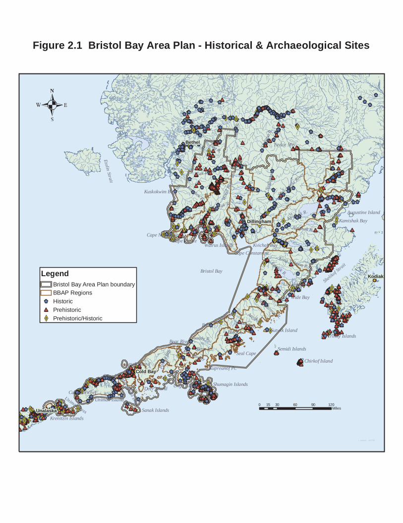
Kodiak
Bethel
Cold Bay
Unalaska
Dillingham
Ilnik
Fog R.
Bear L.
Wood R.
Sandy R.
Aniak R.Black L.
Nusha
gak
Aniak
R.
Wide Bay
Meshik R.
Egegik R.
Seal Cape
Otter Pt.
Togiak R.
Eek River
Bear River
Pavlo
f Bay
Alagnak R.
Kvichak R.
Holitn
a R.
Kanetok R.
Togiak Bay
Bering Sea
Amak Island
Deer Island
Port Moller
Cape Pierce
Taylor Mts.
Unimak Pass
Kvichak Bay
Bristol Bay
Unga Island
Seal Islands
Kamishak Bay
U. Ugashik L.
Sutwik Island
Kupreanof Pt.
Morzhovoi Bay
Cape Sarichef
Cape Newenham
Kuskokwim Bay
Etolin Strait
Unimak IslandSanak Islands
King Salmon R.
King Salmon R.
Walrus Islands
Chirkof Island
Semidi Islands
Mulchatna
River
Shelikof Strait
Trinity Islands
Cape Constantine
Augustine Island
Shumagin Islands
Krenitzin Islands
Wood
River
Mou
ntains
LegendBristol Bay Area Plan boundaryBBAP RegionsHistoricPrehistoricPrehistoric/Historic
0 30 60 90 12015Miles
r. carlson 6/17/05
Figure 2.1 Bristol Bay Area Plan - Historical & Archaeological Sites

Chapter 2 - Instream Flow
2 - 32 September 2013 Bristol Bay Area Plan
Instream Flow Goal Instream Flow. Maintain water quantity and quality sufficient to protect the human, fish, and wildlife resources and uses of the region. Management Guidelines A. Stream Uses to Consider for In-stream Flow Reservation (General). Streams and other waterbodies may be considered for instream flow reservations under AS 46.15.145. Such reservations are intended to maintain a specified instream flow or level of water at a specified point on a stream or body of water, or a specified part of a stream, throughout the year or for specified times. The purposes of the reservation (defined in the statute) include: 1) protection of fish and wildlife habitat, migration, and propagation; 2) recreation and park purposes; 3) sanitary and water quality purposes; and 4) navigation and transportation purposes. B. Priorities. No additional in-stream reservations of water are recommended within the planning area. The need for such reservations should be reevaluated should the plan be revised in the future. Proposals for major new developments requiring substantial water use or uses of water that will negatively impact instream flows needed to produce fish, sustain water quality, provide for navigation, and/or recreation should include an evaluation of the need for an instream water reservation or other forms of instream flow protection. C. Process for Determining Reservations. Requests for instream water reservations will be adjudicated by the Department following the procedures identified in 11 AAC 93.141-147. In general, these procedures require establishing the management objectives of the waterbody, estimating the quantity of water seasonally available, determining the amount of water already appropriated, and projecting the instream flow requirements for the uses and resources to be protected. D. Other Guidelines Affecting In-stream Flow. Several other guidelines will affect instream flow. See other sections of this chapter.

Chapter 2 - Materials Resources
Bristol Bay Area Plan September 2013 2 - 33
Materials Resources Background The planning area has an abundance of sand, gravel, and quarry materials to meet the needs of construction. Of course, these resources are not always ideally suited or ideally located for a given project. Nonetheless, most needs can be met with local materials. Goal Land for State-Owned Material Sites. Maintain in state ownership and make available to public and private users. Assure that material sites are sufficient and suitably located to meet long-term economic needs of the area for materials resources. Management Guidelines A. Preferred Material Sites. When responding to a request for a material sale or identifying a source for materials, the highest priority should be given to using existing upland material sources. Using materials from wetlands, lakes, tidelands, and active or inactive floodplain rivers or streams should be avoided unless no feasible public upland alternative exists. As a general policy, sales or permits for gravel extraction will not be permitted in known fish spawning areas. Material sites shall be maintained in public ownership. B. Maintaining Other Uses and Resources When Siting and Operating Material Sites. Before materials are extracted, the manager will ensure that the requirements of the permit or lease adequately protect other important resources and uses. The disposal of materials should be consistent with the applicable management intent statement and management guidelines of the plan. C. Land Sales in Areas of High Material Potential. Generally, if a settlement area contains sand and gravel deposits, rock sources or other similar, high value material resources, a pit area should be identified during subdivision design and retained in state ownership for future use. D. Screening and Rehabilitation. Material sites should be screened from roads, residential areas, recreational areas, and other areas of significant human use. Sufficient land should be allocated to the material site to allow for such screening. Rehabilitation of the site shall follow the requirements of AS 27.19.020 and 11 AAC 97.250.

Chapter 2 - Materials Resources
2 - 34 September 2013 Bristol Bay Area Plan
E. Coordination with Local Governmental Bodies. Prior to granting authorization for materials sales, the DNR should coordinate with the appropriate borough and/or city to determine the applicable zoning requirements. F. Other Guidelines Affecting Materials. Other guidelines will affect the use of material resources. See other sections of this chapter.

Chapter 2 - Mineral Resources
Bristol Bay Area Plan September 2013 2 - 35
Mineral Resources Background Mineral resources in the Bristol Bay planning area include metallic base, precious, platinum-group, rare earth, and the industrial rocks and minerals. The minerals occur in a wide range of deposit types. The metallic mineral deposits can be divided into placers and lodes. Almost all state land within the planning area is managed for multiple use and is open to mining. The state selected much of the land in the planning area because of its mineral potential, as well as its potential for oil and gas, agriculture, and its recreation and wildlife values. Exploration and development of mineral resources involves considerable investment of time and monetary resources. A small fraction of prospects that are investigated actually result in identification of a site that is economic to develop. If a deposit proves economic for development, state and federal regulations and additional stipulations determined through the permitting process, will ensure that other resource values are protected. The area has not been a significant producer of placer gold, compared with other areas of the state. The most significant placer gold district is the Nyac district, located in the extreme northwest portion of the planning area. The district has produced approximately 500,000 ounces gold and active placer mining continues to the present; due to the number of placers at Nyac, it is speculated that significant lode sources may be present. Placer gold has also been produced as a byproduct or co-product from the platinum placers in the Goodnews district. This district has produced a significant amount of platinum and for many years was the only domestic platinum producer in the U.S. The area has been the focus of a number of exploration programs to locate the lode source or sources of the platinum and gold. Some consider the tide and submerged lands to contain significant additional reserves of platinum and gold. Lastly the Bonanza Hills area has produced a modest amount of placer gold from reworked glacio-fluvial deposits. Lode deposits of the area can be divided into several deposit types: 1) mesothermal gold deposits15, 2) epithermal gold deposits16, 3) porphyry copper17 systems with related skarns18, 4) magmatic segregation deposits, and 5) greisens19. The most significant mesothermal gold system found to date is perhaps that in the Shotgun Hills; a drill indicated resource of
15 Gold deposit formed at intermediate depths and temperatures; commonly with good continuity and a distinct alteration sequence. 16 Precious metal deposits formed at shallow depths and formed at low temperatures; commonly in volcanic terranes. 17 Large tonnage and low-grade copper deposits associated with granitic plutons; gold, silver, and molybdenum commonly occur as byproducts or co-products. 18 Deposits formed in the wall rocks adjacent to a pluton such as a granite. 19 An altered granitic rock composed of quartz and mica (muscovite) and rich in fluorine; usually associated with tin and topaz.

Chapter 2 - Mineral Resources
2 - 36 September 2013 Bristol Bay Area Plan
approximately one million ounces has been estimated. Epethermal gold deposits can be divided into two separate types based on location and associated pathfinder elements. A group of mercury-gold epithermal deposits occurs in a wide belt trending northeast in the uplands areas west of the Nushagak basin. The other epithermal system is of a low-sulfur, gold-silver dominant variety that occurs in Tertiary and younger volcanic rocks on the Alaska Peninsula. The porphyry copper deposits consist of intrusive related copper±molybdenum±gold±silver systems and associated skarn (wall rock-hosted) deposits with base and precious metals. These are part of a complex magmatic terrane which extends down the Alaska Peninsula; many prospects are known. The most significant and well documented of these deposits is the Pebble Copper deposit, 19 miles northwest of Iliamna, which is currently being considered for development; a very large (a billion tons or more) low-grade copper-gold-molybdenum resource has been outlined by drilling at Pebble Copper. The Kemuk deposit, located sixteen miles west of Koliganek, is a magmatic segregation deposit of iron and titanium hosted in a pyroxenite; an inferred resource of 2.4 billion tons is present. The Kemuk deposit has potential to contain platinum group metals. Nearby Sleitat Mountain contains a tin-tungsten-silver-bearing topaz-quartz greisen. An inferred resource of 29 million tons is indicated. It is anticipated that exploration activities will intensify on the large block of state lands in the north central portion of the planning area due to the perceived attractiveness of working on state-owned lands, especially during periods of rising metal prices. The planning area, in general, has large quantities of sand, gravel, and quarry materials. There has been little need for these materials except in the vicinity of communities that require them for airport and road construction or upgrades. There has been little study of the occurrence of the industrial rocks and minerals. Because the region contains a number of young volcanic rocks, zeolites, a group of minerals used as filter media and produced from the alteration of vitreous volcanic rocks, are abundant locally. Notable zeolite occurrences are found in the Lake Iliamna area. Asbestos minerals form from the alteration of olivine-rich ultramafic rocks. Potential for asbestos occurs wherever these ultramafic rocks are found, especially in the Goodnews mafic-ultramafic belt where some asbestos minerals have been identified. Goals Mineral Resources. Make metallic and non-metallic minerals available to contribute to the mineral inventory and independence of the United States and Alaska. Economic Development. Contribute to Alaska’s economy by making subsurface resources available for development, which will provide job opportunities, stimulate economic growth, and establish a source of state revenue. Environmental Quality and Cultural Values. Protect the integrity of the environment and affected cultures when developing subsurface resources.

Chapter 2 - Mineral Resources
Bristol Bay Area Plan September 2013 2 - 37
State Support of Mining. Aid in the development of infrastructure such as ports, roads, railroads, and continue to provide geologic and geophysical mapping and technical support to the mining industry. Management Guidelines A. Access. Access to and across public lands for mineral exploration and development is to be ensured. Land disposals and other authorizations are to be cognizant of access and road corridors proposed by the DNR and ADOT/PF and should not be allowed where such disposals or authorization would conflict with access considerations. B. Mineral Exploration. By statute, exploration for locatable minerals is allowed on all state lands except those specifically closed to location. A land use permit is required under most circumstances. Hand prospecting and exploration activities which involve no significant surface disturbance generally do not require a permit. The DNR may determine that some forms of access will not be allowed in specific areas to avoid resource damage. C. Open to Mineral Location. By statute, all state lands are open to mineral location unless specifically closed. Where an area is open to mineral location, a miner has the right to stake a mining location regardless of the surface use designation or classification. Any adverse effects of mining on surface resources or uses will be managed through compliance with state laws and regulations and borough ordinances and management intent and guidelines in this plan. Reclamation activities are regulated under the Mining Reclamation Act (AS 27.19) and state regulations (11 AAC 97). D. Mining in Fish Habitat. When the DNR issues a permit for mining in or adjacent to a fish stream, conditions of the permit will require any necessary measures such as levees, berms, seasonal restriction, and settling ponds that will allow the operation to meet water quality standards, and statutes and regulations governing the protection of fish. Mining in fish streams requires permits from the ADEC and ADF&G. Such permits are not required in tide and submerged lands or estuarine areas outside of the intertidal channel exposed at mean low water. The intertidal channel is that portion of the bed and banks below the mean high water level. However, a Special Area Permit issued by ADF&G is required if the project is located within a legislatively designated area, including uplands, estuaries or tidelands. E. Offshore Prospecting Permits (OPP). Under AS 38.05.250 an exclusive right to prospect for deposits of minerals offshore may be granted through authorizations issued by DNR. DNR determines what areas will be offered for offshore prospecting. No areas within the plan boundary are currently open for permits. If workable mineral deposits are found offshore, the permittee must apply for a lease in order to develop the mineral deposit. Units designated Habitat because of high fish or wildlife habitat values are areas of significant surface use by fish or wildlife. The ADF&G has stated that it has initially determined mining

Chapter 2 - Mineral Resources
2 - 38 September 2013 Bristol Bay Area Plan
in estuarine areas designated Habitat to be a nonconforming use under the ACMP20. The ACMP procedures will be used to determine whether mining can be made a conforming use and if mitigation is possible, impose the appropriate mitigating measures needed to protect fish and wildlife resources. F. Mineral Closing and Leasehold Location Orders. No new mineral closing orders have been adopted as part of this plan. Users should check for any closure orders that may be in effect for areas in which they intend to work. One mineral closing order, adopted with the original (1984) Bristol Bay Area Plan closed a large number of streams to mineral entry; Mineral Closing Order 393 closed a large number of streams in the Nushagak-Mulchatna river drainage as well as some on the Alaska Peninsula. The 2005 BBAP inadvertently changed the designation of Habitat in the 1985 BBAP to another designation for certain streams. The 2013 BBAP revision corrects this unintended change and all streams, including their adjacent riparian area, are designated Habitat that are affected by this MCO21. A number of other mineral closing and opening orders affect settlement lands in the Dillingham, Aleknagik, and the Nunavaugaluk Lake area. Mineral Leasehold Location Order 1 affects large acreages of state land in the upper Mulchatna drainage as well as state lands around the eastern portion of Lake Iliamna. As of the date of this plan, the following mineral orders are in effect: Table 2.1: Mineral Closing, Opening, and Leasehold Location Orders
Mineral Order General Vicinity Acreage Mineral Closing Order 393 Nushagak-Mulchatna R. and AK Peninsula 213,697 Mineral Closing Order 562 Aniak River portion of this plan ------- Mineral Closing Order 304 Nunavaugaluk Lake 2,360 Mineral Closing Order 305 Weary R.-Snake River Settlement Area 13,393 Mineral Closing Order 196 Warehouse Mountain Area 10,386 Mineral Closing Order 443 East Side of Aleknagik Road 2,368 Mineral Closing Order 570 Nelson Lagoon Reconveyance 3,840 Mineral Closing Order 249 Jack Rabbit Hills 22,831 Mineral Closing Order 552 Various University Lands in Alaska N/A Mineral Closing Order 754 Ekuk 5 Mineral Closing Order 650 King Cove 185 Mineral Closing Order 598 Balboa Bay (north of Sand Point) 52 Mineral Closing Order 644 Sand Point 59
20 The Alaska Coastal Management Program was terminated on July 1, 2011, pursuant to AS 44.66.030. 21 Note to adjudicators: The riparian area affected by MCO 393 may be greater than 100’. Consult the case-file to determine the actual width. USGS quadrangle maps are included that indicate specific widths and these may be greater than 100’.

Chapter 2 - Mineral Resources
Bristol Bay Area Plan September 2013 2 - 39
Mineral Order General Vicinity Acreage Mineral Closing Order 622 Sand Point 2 Mineral Closing Order 521 Morzhovoi Bay 4 Mineral Closing Order 642 False Pass 27 Mineral Closing Order 239 North end of Upper Ugashik Lake (Univ.) N/A Mineral Closing Order 733 Egegik 3 Mineral Opening Order 702 Warehouse Mountain Area 1,112 Leasehold Location Order 1 Upper Mulchatna R.-East Iliamna Lake 1,920,327 Leasehold Location Order 6 Aniak River portion of this plan --------
Leasehold Location Order 1 (1984) restricted mining over large areas of Regions 7, 8, and 9 to leasing. Rights to locatable minerals on lands owned by the State of Alaska are obtained by making a mineral discovery, staking the boundaries of the location, and recording the certificate of location in the designated time period. In most areas, such a location is a “mining claim”, which gives the owner an immediate property right to mine the deposits. However, in areas of the state that have been restricted to leasing, the location is a “leasehold location”, not a mining claim. The leasehold location must be converted to an upland mining lease before mining begins. No mining of minerals on leasehold locations may take place, except for limited amounts necessary for sampling or testing until a mining lease has been obtained. The leasing process includes the exclusive right to convert the leasehold location to a noncompetitive lease. There is no lease sale or open bidding. G. Coal Leasing. Those lands that are currently available for coal leasing will continue to be available under this plan.

Kodiak
Bethel
Cold Bay
Unalaska
Dillingham
Bering Sea Bristol Bay
Kuskokwim Bay
Sanak Islands
Shelikof Strait
Shumagin Islands
LegendBristol Bay Area Plan boundaryBBAP Region boundaryMineral Closing OrderMineral Opening OrderLeasehold Location Order
0 30 60 90 12015Miles
r. carlson 6/15/05
Figure 2.2 Bristol Bay Area Plan - Mineral Closure Orders, Leasehold Location Orders, & Mineral Opening Orders

Kodiak
Bethel
Cold Bay
Unalaska
Dillingham
Bering Sea Bristol Bay
Kuskokwim Bay
Sanak Islands
Shelikof Strait
Shumagin Islands
LegendBristol Bay Area Plan boundaryBBAP RegionsDeposits and ProspectsPlacers
0 30 60 90 12015Miles
r. carlson 6/16/05
Figure 2.3. Bristol Bay Area Plan - Mineral Resources: Deposits, Prospects, and Occurrences
Goodnews
Nyac
Kemuk
Shotgun
Pebble
Sleitat
Fog Lake
Pyramid
ApolloAlaska
Kamishak
BonanzaHills
RexMike
Bee Crk

Chapter 2 - Oil and Gas
2 - 42 September 2013 Bristol Bay Area Plan
Oil and Gas It is probable that significant oil and gas resources are present in the Bristol Bay region. The planning and decision making processes for oil and gas lease sales occur under a separate section of Alaska Statutes (AS 38.05.180) and these processes are not included as part of area plans. For this reason, the Area Plan does not make development decisions related to these resources. Nonetheless, surface facilities related to oil and gas development are recognized as appropriate where oil and gas potential is present. Background The area encompassed by the Bristol Bay Area Plan contains high potential for oil and gas reserves. It contains parts of, or is on the margin of, major sedimentary basins which are believed permissive of hydrocarbon formation since naturally occurring oil seeps are found in the region. The northwest side of the Alaska Peninsula is underlain by a major sedimentary basin that trends sub-parallel to the Peninsula. This basin, variously referred to as the North Aleutians basin, the Bristol Bay basin, or the Alaska Peninsula basin has an offshore axis (Figure 2.4). The extreme northern portion of the basin is sometimes referred to as the Nushagak basin. The basin thickens to the southwest and thus is shallowest in the lower Nushagak-Dillingham area. Considering the great size of the area, only a small number of exploratory or stratigraphic wells have been drilled onshore and offshore. A number of these have contained oil and gas showings. Two other small unexplored offshore basins are on the southeast (Pacific Ocean) edge of the Bristol Bay planning area; these are known as the Shumagin basin and the Sanak basin. Little is known of the potential for these two basins and they would require offshore exploration and production facilities. The highest potential for discoveries of economically recoverable oil and gas on state land is probably that area of the western Alaska Peninsula on the margin of the North Aleutians (Bristol Bay) basin. The potential for substantial gas reserves may be higher than the potential for oil. The Bristol Bay Basin is comprised of sedimentary and volcaniclastic rocks that range in age from Jurassic to Holocene. However, the thickest portion of the stratigraphy, and that which will be of interest to those exploring on state lands, is the thick Tertiary section and portions of the Cretaceous. Important Cretaceous and Tertiary formations, i.e. those that have yielded oil and gas shows, include the Milky River, Bear Lake, Stepovak, Tolstoi, and Chignik formations. These rock units show the proper thermal maturity to host petroleum resources. The greatest unknown factor is the effect that clays which are derived from altered volcanic

Chapter 2 - Oil and Gas
Bristol Bay Area Plan September 2013 2 - 43
rocks may have played on limiting the large scale migration of oil to suitable traps. Approximately nineteen wells have been drilled on the uplands of the Alaska Peninsula in an area extending from Egegik to Cape Leontovitch. A number of these wells have showings of oil and gas. The Alaska Division of Oil and Gas, has proposed an exploration licensing and exploration leasing program for the Bristol Bay onshore area that generally encompasses the Dillingham-King Salmon and Alaska Peninsula areas of state land. The program is currently supported by a range of regional Native corporations, communities, and borough governments. This is largely part of an effort by the various entities to bring about economic diversification to an area that has been heavily dependent upon commercial salmon fishing, an industry which in recent times has struggled with low commodity prices and unpredictable returns. The Alaska Department of Natural Resources, Lake and Peninsula, Bristol Bay, and Aleutians East Boroughs have signed a memorandum of understanding (MOU) in support of oil and gas lease sales and licensing of state land in the Bristol Bay and Alaska Peninsula region (March 17, 2004). Similar MOUs are in effect between the DNR and The Aleut Regional Native Corporation (December 18, 2003) and the DNR and Bristol Bay Native Corporation (July 10, 2003). The 1984 Bristol Bay Area Plan designated or co-designated most state lands on the Alaska Peninsula as Oil and Gas Lands. Oil and gas lease planning is however, no longer part of the purview of area land plans. Changes in state statutes (AS 38.05.180) created a separate planning and permitting process for oil and gas exploration and development that is coordinated by the DNR’s Division of Oil and Gas. The exploration licensing program for Bristol Bay and the leasing program for the Alaska Peninsula onshore areas will be the subject of a future Best Interest Finding by the Alaska Division of Oil and Gas. Management Guidelines This plan defers any decisions regarding licensing or leasing of oil and gas to the DNR’s existing licensing and leasing process. Oil and gas sales are not subject to the regional land planning process, but follow the planning process established under AS 38.05.180. The land use designations of the plan are multiple-use in character (primarily General Use) and do not preclude oil and gas development.

Kodiak
Bethel
Cold Bay
Unalaska
Dillingham
Bering Sea Bristol Bay
Kuskokwim Bay
Sanak Islands
Shelikof Strait
Shumagin Islands
LegendBristol Bay Area Plan boundaryBBAP RegionsOil & Gas WellsOil & Gas BasinsCoal Basins
0 30 60 90 12015Miles
r. carlson 6/16/05
Figure 2.4 Bristol Bay Area Plan - Oil & Gas and Coal Basins
ShumaginBasin
Kodiak Shelf
St. George
Shelikof
TugidakBasin
SanakBasin
UnimakPlateau
Bristol Bay Basin
Nushagak Basin
Holitna

Chapter 2 - Public Access Easements, Neighborhood Trails, and Public Access
Bristol Bay Area Plan September 2013 2 - 45
Public Access Easements, Neighborhood Trails, and Public Access Goals Trails. Maintain, enhance, or provide adequate access within areas of development and between areas of current or future development. Public Access. Maintain, enhance, or provide adequate access to public and private lands and resources. Provide for future trail and access needs. Protect or establish trail corridors to ensure continued public access. Management Guidelines: Public Access – General Before selling, leasing, or otherwise disposing of the land estate, DNR will reserve public use easements pursuant to the requirements of 11 AAC 51.015. This section of administrative code establishes when public access easements are to be reserved and the widths of these easements. Specific standards for section-line easements are identified in 11 AAC 51.025 and for easements along, and to and along navigable and public waters, in 11 AAC 51.045. These sections of Administrative Code shall be used as the basis for the reservation of public access easements in authorizations granted by DNR. Management Guidelines: Access Corridors A. General. The following guidelines pertain to the access corridors22 provided by trails within developed or developing areas, trails between these areas, and trails of regional or statewide significance. This is a more specific application of the general public use easement. Access corridors provide movement areas for people and wildlife. They include the area of movement and, as appropriate, a buffer area adjacent to the corridor sufficient to provide separation from other uses. The width and siting of trail corridors depends upon their function and location. Easements are used to create an access corridor, similar to the more general public use easements described previously.
22 Access corridors differ from public use easements in that they apply to the trail but may also include a buffer area. Access corridors can be created by the imposition of a public use easement for the trail or through the creation of a buffer, which is usually an area of transition space between different and often conflicting uses. Where it is an easement, a single public use easement is created; it would include both the trail and the buffer area adjacent to the trail. Where a buffer is used, a separate easement would be formed for the area of the buffer, reflecting the distinct use of a buffer in addition to the public use easement for the purpose of movement.

Chapter 2 - Public Access Easements, Neighborhood Trails, and Public Access
2 - 46 September 2013 Bristol Bay Area Plan
B. Requirement for Access Corridors. The Department shall assess the need for public access before selling, leasing, or otherwise disposing of the land estate. If local access needs are identified through the adjudication and agency or public review process, access corridors shall be reserved. This will occur through the retention of state land in public ownership or through the creation of a public use easement. Under either approach, the public is to have the right of access within the area of state land or the public use easement. C. Ownership Considerations. The following factors shall be considered by DNR in making the decision to retain the access corridor under state ownership or to provide for public access through a public use easement:
1. If the access (usually a trail within a developed or developing area) is used as a neighborhood collector trail that connects to a public open space system or a trail of regional significance, access should be retained in public ownership.
2. If a trail is used as access by neighborhood residents, it should be dedicated to local government or established as an easement to an entity willing to accept maintenance and management responsibility. This would typically occur when the purpose is to establish access between lots or to improve pedestrian circulation within a subdivision.
3. If the access provides a connection to other areas and is considered of regional or statewide significance, it should be retained in public ownership.
D. Width of Trail Corridors. The width of the access corridor23 shall be determined according to its function and location:
1. Within developed or developing areas, access corridors shall not be less than 20 feet in width for pedestrian movement and not less than 40 feet if motorized movement (other than car or truck) can be expected in addition to pedestrian travel. In areas where topographic or other conditions restrict development, reduced widths may be considered if public safety and the movement function provided by the trail are adequately maintained.24
2. In all other areas, the width shall vary with terrain, function, and the need for separation from other uses, but shall not be less than 50 feet.
3. Trails or other access facilities of statewide or regional significance shall not be less than 100 feet in width.
23 An access corridor includes the tread of the trail and an area immediately adjacent to the tread. 24 Note: These standards apply to motorized uses other than cars or trucks, or similar sizes and types of vehicles. If a public use easement is to be established for use by cars or trucks, then the standards of 11 AAC 51.015 apply and the width of this easement is not less than 60 feet.

Chapter 2 - Public Access Easements, Neighborhood Trails, and Public Access
Bristol Bay Area Plan September 2013 2 - 47
E. Buffers. The widths of an access easement may be increased to include an area for a buffer. This area is in addition to the minimum access widths described above in item D. Buffers may be necessary to minimize land use and ownership conflicts, to allow the future siting of public facilities, allow flexibility in routing, provide an adequate area for wildlife movement, or to adapt a trail to specific public uses or aesthetic or environmental concerns. Where buffers are authorized, they will be maintained in their natural condition unless enhancement is required because of existing site degradation. If the buffer is to function as a wildlife movement corridor, then DNR shall consult with ADF&G in the design of the buffer. The width of the buffer will depend upon the function of the access corridor and consideration of the above factors. However, there shall be a minimum of an additional fifteen feet on either side of the access corridor when DNR requires buffers. F. Trail Rerouting. Standards for the vacation and modification of trails are identified in 11 AAC 51.065. Rerouting of trails may be permitted to minimize land use conflicts, reduce duplication in trail routings, or minimize habitat destruction. If trails are rerouted, provision should be made for construction of new trail segments if warranted by type and intensity of use. Rerouting trails shall be done in consultation with affected private users and public agencies. Rerouted trails should allow the same uses and activities as the original trail. G. Alignment with Crossings. When it is necessary for power lines, pipelines or roads to cross trail buffers, crossings should be at a 90-degree angle to the buffer. Vegetative screening should be preserved at trail crossings. H. Access to Trailheads. Coastal access across state tidelands to designated trail corridors that begin at the shoreline will be protected. Management Guidelines: Public Access A. Retain access: General. Improve or maintain public access to areas with significant public resource values by retaining access sites and corridors in public ownership; reserving rights of access when state land is sold or leased; or identifying, managing and legally validating RS 2477 (Revised Statute Section 2477) rights-of-way. Standards for the vacation of easements are contained in 11 AAC 51.065. Information regarding RS 2477 rights-of-way easements can be found at the DNR web site: http://dnr.alaska.gov/mlw/trails/index.cfm or is available in DNR’s Bristol Bay Easement Atlas. B. Retain Access: Road Corridors. Retain state land situated within proposed road corridors, as identified in maps 3-1 to 3-22. The Alaska Department of Transportation has identified a variety of road routes necessary to support community expansion, access

Chapter 2 - Public Access Easements, Neighborhood Trails, and Public Access
2 - 48 September 2013 Bristol Bay Area Plan
between communities, and industrial/mineral development25. These routes are identified on maps 3-1 to 3-22. DNR should avoid disposing of state land situated within these corridors. Prior to undertaking disposals or authorizations that would create permanent and substantial uses, DNR shall consult with ADOT/PF on route placement. Disposals or authorizations within these road corridors are only appropriate if it is determined that a proposed use would not be situated within a road corridor, ADOT/PF determines that the proposed use would not be inconsistent with the intended road, or ADOT/PF determines it is unlikely that the final road route would encompass the proposed use. See also the Resource Allocation Tables in Chapter 3 for specific management intent for management units containing portions of a proposed road corridor. C. Access to Non-State Lands. Reasonable access will be provided across state lands to other public and private lands. Existing legal access will not be precluded unless equivalent access is available. D. Management of ANCSA 17(b) Easements. The state will identify and assert 17(b) easements in order to provide access to federal and state land. Generally, DNR will not accept management of 17(b) easements unless the state already actively manages a portion of the trail or easement, or state management will best protect public access to state lands. Information regarding ANCSA 17(b) easements can be found at the DNR web site: http://dnr.alaska.gov/mlw/trails/index.cfm or is available in DNR’s Bristol Bay Easement Atlas. E. Access for Development. When an access route is constructed for resource development over state land, public access to mineralized areas, recreation, fish, wildlife, or other public resources should be retained. If the new resource facility is likely to be of limited duration and provides superior access to the current means of access, the state should retain the new facility for public access. If the new facility will not or should not provide public access, the current means of public access should be retained. F. Limiting Access. Access to state lands may be curtailed at certain times to protect public safety, provide for the remediation of public use areas, allow special uses, and prevent harm to the environment, fish, and wildlife. Public access may be limited because of the presence of fire management operations, timber harvest, high soil moisture content when vehicular traffic may cause damage to the base or sub-base, and sensitive populations of fish or wildlife. G. Siting and Constructing Temporary and Permanent Roads or Causeways. Temporary and permanent roads or causeways will, to the extent feasible and prudent, be routed to avoid vegetated tidal flats, avoid streams and minimize alteration of natural 25 Southwest Alaska Transportation, Alaska Dept. of Transportation and Public Facilities, 2002. These routes include the following: Williamsport to Pile Bay Road, Pebble Copper Road, Alaska Peninsula Road Corridor, King Cove to Cold Bay, Ekuk to Clarks Point Road, and Iliamna to Nondalton Road. These routes adjoin a combination of private, state, Native, and federal lands.

Chapter 2 - Public Access Easements, Neighborhood Trails, and Public Access
Bristol Bay Area Plan September 2013 2 - 49
drainage patterns, and avoid long-term adverse effects on water quantity or water quality. If a temporary road is routed through vegetated tidelands, clean fill will be required and construction methods that facilitate removal of the fill will be required. H. Joint Use and Consolidation of Surface Access. Joint use and consolidation of surface access routes and facilities should be encouraged wherever it is feasible and prudent to do so26. Surface access also should be sited and designed to accommodate future development and avoid unnecessary duplication. I. Anchorages. Activities within anchorages27 are allowed if they will not significantly diminish the public’s continued ability to use the anchorage. This policy is to be interpreted conservatively, particularly if the anchorage has been historically used (or can be expected to be used) as a safe harbor for vessels from storms. Aquatic farms and floating facilities should not be sited in anchorages necessary to, and used for, the anchoring of vessels, and are not to be authorized if the anchorage has been historically used as a safe harbor. The effect upon anchorage capacity should be considered when adjudicating authorizations for uses and facilities, to ascertain that continued public use of the anchorage can occur. J. Other Guidelines Affecting Public or Trail Management. A number of other guidelines may affect public and trail access management. See other sections of this chapter.
26 Note: There are instances where access routes should not be consolidated; their purposes may be at odds with one another or one consolidated route cannot effectively provide access to resources required by the public. 27 The Bristol Bay Area Plan does not identify anchorages on its plan maps. There are many potential anchorages but these are not identified in official sources. Therefore, in adjudication decisions affecting tidelands, whether the tideland area is used as an anchorage must be established.

Chapter 2 - Recreation, Tourism, and Scenic Resources
2 - 50 September 2013 Bristol Bay Area Plan
Recreation, Tourism, and Scenic Resources Background The Bristol Bay area is known for its world class fishing, hunting and other outdoor recreation opportunities. In part to support these activities, many federal and state parks, refuges, preserves, monuments, and recreation sites have been created. The largest state park in Alaska, the 1.6 million acre Wood-Tikchik State Park, is a major recreational asset of the region. Other significant sites include: Lake Clark National Park, Aniakchak National Monument and Preserve, Katmai National Park and Preserve (Brooks Camp and the Valley of 10,000 Smokes), the Alaska Peninsula, Alaska Maritime, Izembek, Togiak, and Becharof National Wildlife Refuges, as well as several National Wild and Scenic Rivers: the Alagnak, Chilikadrotna, Mulchatna, and Tlikakila Rivers. There are also many private camps and lodges that provide support for recreational users. While many of these private operations are in or adjacent to the public lands mentioned above they also serve other areas. Notable concentrations outside of these dedicated public lands are found in the Iliamna Lake, Naknek Lake, lower Nushagak and Alagnak drainages. Goal Recreation Opportunities. Lands will be provided for accessible outdoor recreational opportunities with recreational facilities where the demand warrants such facilities. In addition, undeveloped lands should be provided for recreation pursuits that do not require developed facilities. These opportunities shall be realized by:
• providing recreation opportunities on less developed land and water areas that serve multiple purposes such as habitat protection or mineral resource extraction;
• assisting communities through cooperative planning, conveyance of state lands, and grants-in-aid for parks and trails within population centers;
• encouraging commercial development of recreational facilities and services through concession contracts, land sales, leases, and permits where public recreation needs can most effectively be provided by private enterprise, while minimizing environmental impacts and conflicts with the existing users of an area; and
• protecting recreation resources including public access, viewsheds, quiet, fish and wildlife important for recreation, and the unique natural characteristics of the planning area.

Chapter 2 - Recreation, Tourism, and Scenic Resources
Bristol Bay Area Plan September 2013 2 - 51
Management Guidelines A. Coordination with Other Landowners and Users of an Area. Recreation management, including the location and management of recreation facilities, will take into account the current, and likely, management of lands managed by local governments, Native corporations and other private landowners, and compatibility with the existing uses of an area. B. Roles of Different Public Land Owners in Providing Public Recreational Opportunities. Generally, the state’s role is to retain and manage land supporting recreational opportunities of regional or statewide significance. State and federal governments are most capable of providing recreational opportunities that require large land areas, while local government is generally best suited for providing and managing community recreation opportunities. To recognize local government’s role in providing community recreation needs, the state may transfer state land including those designated General Use (Gu), Public Recreation and Tourism-Dispersed (Rd) or Public Recreation and Tourism-Public Use Sites (Rp) within or near existing communities, if this action is in the overall best interest of the state (AS 38.05.810). The selection of these sites shall be agreed to by local government and the state, and shall be contingent on the local government’s commitment to develop and maintain the recreation uses, facilities, and values of these areas. In areas where the state is retaining public use sites (management units designated Public Recreation and Tourism-Public Use Site (Rp) the state may consider cooperative management with local government if this would improve management of the resource. Entering into a management agreement with an entity with more direct presence in the area should result in better protection of the resource and enjoyment by the public. This management agreement to operate the public use site should fulfill all of the obligations that the state would normally bear (protecting public safety, habitat, etc.) but will gain the efficiency of having more local control of the site. C. Public Use Sites. Uses that adversely affect public use sites or areas should not be authorized. Uses that are made available to the public, are recreational or other sites (such as airstrip development or docks) may be authorized if consistent with the management intent for the public use site or area, and if there is a demonstrated public need. Specific requirements relating to the siting and development of public use sites exist in the Nushagak & Mulchatna Rivers Recreation Management Plan (DNR, April 2005) (RRMP). Consult this plan when authorizing activities at public use sites within the planning area of the RRMP. See also Management Guideline J, which defines the area of application of the RRMP. D. Public Recreation Facilities
1. Public Use Cabins. A system of public use cabins should be established in state parks. Generally, such facilities should not be provided on general state land, which is the focus of this plan.

Chapter 2 - Recreation, Tourism, and Scenic Resources
2 - 52 September 2013 Bristol Bay Area Plan
2. Location of Recreation Facilities a. Preferred Locations. Recreation facilities, including public use cabins, minimum development campsites, mooring buoys and other low intensity facilities for the general public (i.e. not private commercial facilities), are appropriate at sites that encourage public use at a particular location, direct public use away from inappropriate locations, accommodate competing or conflicting uses, and minimize damage to the environment. b. Inappropriate Locations. Recreation facilities are not appropriate where the management intent of this plan is to maintain the natural condition of the area free from additional concentrations of recreation users or significant evidence of human use. In addition, recreation facilities should not be placed adjacent to cultural resource and archaeological sites that might subject these sites to vandalism or disturbance because of increased public use.
E. Private Commercial Recreation Facilities and Operations on State Land. Lodges (including floating lodges), tent camps, floats, or other private commercial facilities and operations designed to be run as or to support private commercial recreation facilities may be authorized if the facility or operation fulfills the conditions outlined in this section, conforms to the requirements of AS 38.05.070-.075, AS 38.05.850, or conforms to a management plan prepared in accordance with AS 41.21.302(c) authorizing the facility. The Nushagak & Mulchatna Rivers Recreation Management Plan, April 2005, also has restrictions on structures related to commercial recreation.
1. Siting, Construction, and Operation. The facility or operation should be sited, constructed, and operated in a manner that creates the least conflict with natural values and existing uses of the area. The commercial facility and the use it generates should avoid significant adverse impacts on fish and wildlife habitat and existing uses of an area. To the extent practical, floatlodges should be visually and acoustically hidden from main travel routes, frequently used anchorages, regionally important campsites, and frequently used recreation areas.28 For facilities supporting recreational fish and wildlife harvest, ADF&G should be consulted on the possible effects of increased harvest on fish and wildlife resources, and on established commercial, recreation, and subsistence users. To protect existing habitats, resources, and uses, floating private commercial recreation facilities should not be authorized in the following areas: designated habitat or harvest areas, anchorages, areas designated recreation (Rp or Rd), or areas adjacent to an upland residential subdivision. In addition, they should not be permitted near an authorized aquatic farming operation, known cultural or historic sites, public use cabins, or where the use is prohibited in the management intent statement for a specific management unit in this plan.
28 See the Floating Facilities section in this chapter for additional standards on this use.

Chapter 2 - Recreation, Tourism, and Scenic Resources
Bristol Bay Area Plan September 2013 2 - 53
Private commercial recreation facilities may be authorized in these areas by DNR if it is determined that the permitting of a floating facility is in the best interest of the state and the use is found consistent with the Alaska Coastal Management Program29.
2. Upland Access to Floatlodges. Where the need for upland access to a floatlodge is anticipated, the floatlodge should be anchored or tied where there is legal upland access to the site.
3. Authorizations for Floatlodges. Floatlodges shall also meet the requirements for these structures under Floating Facilities.
F. Commercial Recreation Leasing Processes. There are two processes for leasing state land for commercial recreational facilities – one process is described by AS 38.05.073, the other by AS 38.05.070 and .075. Unless Chapter 3 specifically requires the .073 commercial leasing process, applications may be adjudicated under either process. DNR will determine the appropriate process on a case-by-case basis. ADOT/PF has its own leasing process that applies to land it manages in rights-of-way, airports, materials sites, and other lands and facilities it manages.
1. The .070 / .075 Process. The .070 / .075 process is simpler and faster, but it offers the state less flexibility in choosing the lessee and in structuring lease payments. It is generally suited to small projects with few anticipated impacts. The management intent for the management unit need not specifically state that this type of leasing is an allowed use for it to be authorized under this process.
2. The .073 Process. The .073 process is longer, but it allows submission of alternative proposals for a particular lease, requires more public involvement in reviewing a proposed lease, and offers the state more choices for structuring payments on the lease. The .073 process is generally suited to large projects that are likely to have significant impacts on surrounding areas. Under the .073 process, DNR will give public notice that it intends to solicit proposals for a lease. DNR will then prepare a “request for proposals” that must include specific information on the lease and must be advertised in state and local newspapers. Once a prospective lessee has been chosen, DNR must give public notice and hold public meetings on the preliminary decision to issue the lease. For a .073 lease to be considered in a management unit, the plan must specifically allow for this type of leasing in a given unit before it can be authorized. Since no management units are identified in this area plan specifically for commercial recreation leasing under the .073 process, a plan amendment will be required to accommodate this use. DNR may impose eligibility standards, including proof of the developer’s financial backing and capability, experience in this type of development, ability to meet bonding or insurance requirements, and ability to comply with resource and environmental analysis requirements.
29 The Alaska Coastal Management Program was terminated on July 1, 2011, pursuant to AS 44.66.030.

Chapter 2 - Recreation, Tourism, and Scenic Resources
2 - 54 September 2013 Bristol Bay Area Plan
The .073 process requires that potential economic, social, and environmental impacts of the proposed project must be evaluated. DNR may require the prospective developer to fund additional studies; the studies must involve the appropriate state agencies, and ADF&G must approve any studies involving fish and game.
G. Tideland Permits and Leases Adjacent to Recreation Facilities. Tideland activities may be allowed adjacent to public recreation facilities, including public use cabins, lodges, or fuel stops if the land manager determines that the two uses can be made compatible by design, siting or operating guidelines, or if the land manager determines there is no feasible and prudent alternative for the activity. This guideline also applies to sites reserved for future recreation facilities. The land manager’s determination will be made after consultation with the facility manager. H. Scenic Resources. Facilities on state-owned uplands and tidelands in areas designated Public Recreation and Tourism-Dispersed (Rd) or Public Recreation and Tourism-Public Use Site (Rp) should be located and designed to blend in with the natural surroundings. Stipulations to accomplish this guideline may be attached to a development plan to address location, size, color, materials, requirements for vegetative or topographic screening, or other measures as appropriate. I. Municipal Selections. Some areas of state land that are designated Public Recreation and Tourism-Dispersed (Rd) or Public Recreation and Tourism-Public Use Site (Rp) may be suitable for selection under the Municipal Entitlement Act. The Resource Allocation Tables in Chapter 3 specify if a management unit is considered suitable for municipal conveyance. In order to protect the public values in these recreational lands, the state may attach stipulations to the conveyance. This may include easements to preserve access (trails and campsites), habitat, wildlife, scenic and other values associated with the recreation resources. State land designated Rd or Rp affected by a municipal selection considered appropriate for conveyance will maintain a protected area adjacent to anadromous streams or lakes. This protected area, which will be established by an easement, will extend 100 feet upland from the ordinary high water mark. In areas where the river provides a significant corridor for wildlife movement, the size of this easement may be increased to 200 or 300 feet. The intent of this type of easement is to maintain habitat and public use values, including public access. Within the easement there should be no permanent structures or significant alteration of vegetation. See Table 2.3. J. Nushagak & Mulchatna Rivers Recreation Management Plan. The original Nushagak & Mulchatna Rivers Recreation Management Plan (RRMP) was developed by DNR and other entities to provide the basis for the management of recreation uses and

Chapter 2 - Recreation, Tourism, and Scenic Resources
Bristol Bay Area Plan September 2013 2 - 55
structures on state land within the Nushagak and Mulchatna drainage basin. It was originally adopted in 1990 as an element of the Bristol Bay Area Plan and as an Area Meriting Special Attention in the District Coastal Plan of the Bristol Bay Coastal Resource Service Area30. This plan revision continues the use of the RRMP as an element of the Bristol Bay Area Plan within the navigable waters of the Nushagak-Mulchatna drainage basin and those adjacent uplands designated in the Area Plan as General Use, Public Recreation and Tourism-Dispersed (Rd), Recreation and Tourism-Public Use Site (Rp), or areas co-designated Habitat (Ha) for specific types of recreation activities and facilities. The Revised RRMP is to be used as the basis for decision making for the following types of recreation and related uses: Permanent Facilities, Temporary Facilities, Trapping Cabins, Boat Storage, Airstrip Development, Docks, and ‘Other Uses’, as more fully described in Chapter 3 of the Revised RRMP.31 These definitions are also included in the Glossary. There are a number of restrictions in the application of the Revised RRMP to DNR decision making. It does not apply to areas designated Settlement and Mining in the BBAP, and it does not affect decisions related to municipal entitlement selections, mining or other forms of subsurface use, or oil and gas development. All other types of uses other than those specifically related to recreation are also managed under the auspices of the BBAP. DNR adjudicators should therefore review the management guidelines for specific management units in the BBAP in addition to the listing of allowed and prohibited uses identified in the RRMP. K. Other Guidelines that Affect Recreation, Tourism, and Scenic Resources. Other guidelines will affect recreation, tourism, and scenic resources. See the other sections of this chapter.
30 The Alaska Coastal Management Program was terminated on July 1, 2011, pursuant to AS 44.66.030. 31 The RRMP only covers certain types of activities related to short-term and long-term uses. These are listed in Tables 2.1 and 3.1 of the RRMP. Table 3.1 of the RRMP, for convenience, is also included as Table 2.2 in this Plan; however, adjudicators should read the entire section on allowed uses in Chapter 2 of the RRMP as well as the specific requirements for particular river segments.

Chapter 2 - Recreation, Tourism, and Scenic Resources
Bristol Bay Area Plan September 2013 2 - 56
Table 2.2: Nushagak & Mulchatna Rivers Recreational Management Guidelines (same as Table 3.1 in the RRMP)
RRMPUnit
BBAPUnit Name
ManagementIntent
Perm.Facilities
Temp.Facilities
TrappingCabins
BoatStorage
AirstripDevelopment
Docks -Perm.
Docks -Temp.
OtherUses
1 5-20Lower Nushagak River,Keefer Cutoff to Wood River
Semi-developed Prohibited Prohibited Prohibited
May be Allowed
May be Allowed
May be Allowed
May be Allowed
May be Allowed
25-22,6-49 Iowithla River Corridor Primitive Prohibited Prohibited Prohibited Prohibited Prohibited Prohibited Prohibited
May be Allowed
3 6-26Lower Nushagak River,Ekwok Vicinity
Semi-developed Prohibited Prohibited Prohibited
May be Allowed
May be Allowed
May be Allowed
May be Allowed
May be Allowed
4 6-35 Kokwok River Corridor Semi-primitive ProhibitedMay be Allowed
May be Allowed
May be Allowed
May be Allowed Prohibited
May be Allowed
May be Allowed
5 6-26
Lower Nushagak and Mulchatna River Corridors, New Stuyahok Vicinity
Semi-developed Prohibited Prohibited Prohibited
May be Allowed
May be Allowed
May be Allowed
May be Allowed
May be Allowed
6 6-42 Lower Nushagak Uplands Semi-primitive ProhibitedMay be Allowed
May be Allowed
May be Allowed
May be Allowed Prohibited
May be Allowed
May be Allowed
76-26,6-33
Middle Nushagak River Corridor, Koliganek Vicinity
Semi-developed Prohibited Prohibited Prohibited Prohibited Prohibited
May be Allowed
May be Allowed
May be Allowed
8 6-25 Nuyakuk River Corridor Primitive Prohibited Prohibited Prohibited Prohibited Prohibited Prohibited Prohibited Prohibited
9 6-26Middle Nushagak Corridor, Harris Creek to Nuyakuk River Semi-primitive Prohibited Prohibited Prohibited
May be Allowed
May be Allowed
May be Allowed
May be Allowed
May be Allowed
10 6-02
Middle Nushagak Corridor, Chichitnok River to Harris Creek Semi-primitive Prohibited
May be Allowed
May be Allowed
May be Allowed
May be Allowed Prohibited
May be Allowed
May be Allowed
11 6-13 Middle Nushagak Uplands Semi-primitiveMay be Allowed
May be Allowed
May be Allowed
May be Allowed
May be Allowed
May be Allowed
May be Allowed
May be Allowed
12 6-02 King Salmon River Corridor Primitive Prohibited Prohibited Prohibited Prohibited Prohibited Prohibited ProhibitedMay be Allowed
Amended Plan (2005) for Nushagak &Mulchatna Rivers Recreation Units Management Guidelines Related to Recreation Uses and Structures

Chapter 2 - Recreation, Tourism, and Scenic Resources
Bristol Bay Area Plan September 2013 2 - 57
RRMPUnit
BBAPUnit Name
ManagementIntent
Perm.Facilities
Temp.Facilities
TrappingCabins
BoatStorage
AirstripDevelopment
Docks -Perm.
Docks -Temp.
OtherUses
13 6-02Upper Nushagak and Chichitnok Rivers Corridor Primitive Prohibited Prohibited Prohibited Prohibited
May be Allowed Prohibited Prohibited
May be Allowed
14 6-01 Nushagak Hills Semi-primitiveMay be Allowed
May be Allowed
May be Allowed
May be Allowed
May be Allowed
May be Allowed
May be Allowed
May be Allowed
15 6-09 Lower Mulchatna Rliver Corridor Semi-primitive ProhibitedMay be Allowed
May be Allowed
May be Allowed
May be Allowed Prohibited
May be Allowed
May be Allowed
166-09,6-41 Stuyahok River Corridor Primitive Prohibited Prohibited Prohibited Prohibited Prohibited Prohibited Prohibited
May be Allowed
17
6-09,6-246-30 Koktuli River Corridor Primitive Prohibited Prohibited Prohibited Prohibited Prohibited Prohibited Prohibited
May be Allowed
18 6-09Middle Mulchatna River Corridor, Keefer Creek to Koktuli River Semi-primitive Prohibited
May be Allowed
May be Allowed
May be Allowed
May be Allowed Prohibited
May be Allowed
May be Allowed
19 6-05 Lower Mulchatna Uplands Semi-primitiveMay be Allowed
May be Allowed
May be Allowed
May be Allowed
May be Allowed
May be Allowed
May be Allowed
May be Allowed
20
6-07,6-09,7-06
Middle Mulchatna River Corridor, Chilikadrotna River to Keefer Creek Semi-primitive Prohibited
May be Allowed
May be Allowed
May be Allowed
May be Allowed Prohibited
May be Allowed
May be Allowed
21 7-06 Chilchitna River and Tutna Lake Semi-primitive ProhibitedMay be Allowed
May be Allowed
May be Allowed
May be Allowed Prohibited
May be Allowed
May be Allowed
22 7-06 Upper Mulchatna River Corridor Semi-primitive ProhibitedMay be Allowed
May be Allowed
May be Allowed
May be Allowed Prohibited
May be Allowed
May be Allowed
23 7-06 Chilikadrotna River Corridor Primitive Prohibited Prohibited Prohibited Prohibited Prohibited Prohibited ProhibitedMay be Allowed
24 7-04 Half Cabin Lakes AreaSemi-developed
May be Allowed
May be Allowed
May be Allowed
May be Allowed
May be Allowed
May be Allowed
May be Allowed
May be Allowed
25 7-02 Upper Mulchatna Uplands Semi-primitiveMay be Allowed
May be Allowed
May be Allowed
May be Allowed
May be Allowed
May be Allowed
May be Allowed
May be Allowed

Chapter 2 - Settlement
2 - 58 September 2013 Bristol Bay Area Plan
Settlement Background Some state lands within the planning area are designated Settlement (Se) or Settlement-Commercial (Sc).32 Settlement areas are primarily found in the northern part of the planning area within Regions 6, 7, 8, and 9. Fewer settlement areas occur on the Alaska Peninsula, due to that area’s more remote location, limited accessibility, and suitable areas for settlement. The Settlement designation of a particular management unit is based on whether it has reasonable access by road, water, or air, includes topography that would be suitable for development, and poses minimal conflict with recreation, scenic values, important fish and wildlife resources, or resource development. A summary of the plan’s settlement evaluation follows. Region 5 – Dillingham Area. Past state land sales in the Dillingham area have shown a demand for more private land in proximity to this, the largest community in the Bristol Bay region. State lands in the area of Lake Nunavaugaluk (Snake Lake) and along the road corridor leading north from Dillingham remain in their prior Settlement classification with minor expansion to add some equally suitable land and to allow more flexibility in land disposal design. Region 6 – Nushagak Drainage. Much of the land in the lower drainage is privately owned. There are some lands on the upper Nuyakuk River with suitable terrain and access to be designated Settlement. There are extensive state lands in the remainder of this region, but they are further removed from any population centers, and have higher value for habitat, harvest and recreation. Region 7 – Upper Mulchatna and Chulitna. A former Settlement area at Half Cabin Lakes was maintained in the Mulchatna River drainage. A new block of Settlement land was designated in the Tutna Lake area because of its suitable terrain and the access provided via the lake and other waterbodies. In the Chulitna drainage, a block of state land around the Nikabuna Lakes is designated Settlement because of its suitable terrain and the access provided via the lakes and other waterbodies. Region 8 – Newhalen River. A former block of Settlement land on the west side of the Newhalen River has been expanded into equally suitable adjacent lands. This land is close to the communities of Nondalton, Iliamna and Newhalen and is along a proposed overland
32 There is only one area within this area plan that is designated Settlement-Commercial. This designation is used where state land is to be used for a variety of purposes, including commercial, industrial, or residential development, and few areas exactly fit this need. Once state land is conveyed out of state ownership local zoning, if applicable, controls its use. Use restrictions in state patent are rare.

Chapter 2 - Settlement
Bristol Bay Area Plan September 2013 2 - 59
transportation corridor. Most of the lands are state-selected and cannot be used for Settlement until conveyed from the federal government. Three sections of land near Nondalton are state-owned lands suitable for Settlement. Region 9 – Eastern Iliamna Lake. A former block of Settlement land around Chekok Lake has been expanded into suitable adjacent lands. A block of land along the Pile River is designated Settlement due to its suitable terrain and access. Both of these blocks are close to the community of Pedro Bay and are located along a proposed overland transportation corridor. Another former block of Settlement land around Kakhonak Lake has been expanded into equally suitable adjacent land. Region 11 – Naknek River. An area of state-owned and state-selected land along King Salmon Creek is designated Settlement due to its gentle terrain and suitable access. This land is close to the communities of King Salmon and Naknek. Region 12 – Egegik. A small block of land north of the mouth of the Egegik River is designated Settlement due to its suitable terrain and access. This land is close to the community of Egegik and can be utilized for community expansion. There is also a small block of land around the Jensen Airstrip, west of Becharof Lake, that is designated Settlement. Region 14 – Ugashik Bay. A small block land north of Ugashik Bay is designated Settlement due to its suitable terrain and access. This land is close to the community of Pilot Point. Region 16 – Port Heiden. A block of land around Barbara Creek is designated Settlement. This land has suitable terrain, nearby access, and is located close to the community of Port Heiden. Region 18 – Cape Seniavin/Port Moller. A small block of land, formerly classified Settlement along the coast north of Port Moller will remain so designated. Another block of land around the north shore of Bear Lake is designated Settlement. Though remote from any existing community, this land has suitable terrain and good air access. Region 19 – Herendeen Bay. A block of land at the head of Herendeen Bay has suitable terrain, marine access, and is designated Settlement. Region 21 – Pavlof Bay, Salt Water Lagoon, and David River. A small parcel of land at the head of Pavlof Bay is designated Settlement. Though remote from any community, terrain and access are suitable, and this area may be appropriate for a marine related transportation facility. Other areas designated Settlement include a small tract near Salt Water Lagoon on the Bristol Bay coast and a fairly large area near the David River containing many lakes and streams.
Chapter 2 - Settlement
2 - 60 September 2013 Bristol Bay Area Plan
Other Regions. Because of other values, such as habitat and harvest, and low suitability for settlement due to terrain and access issues, there are no other major blocks of state land designated for Settlement. However, there are large areas of state land, especially in the Nushagak drainage and on the north side of the Alaska Peninsula, that are designated General Use, a multiple use designation which allows settlement if indicated in the management intent of a management unit. Areas designated General Use are usually even more inaccessible and remote and are generally unsuitable for settlement because of adverse topography, poor drainage, and the presence of extensive wetlands. Thus areas designated General Use in the planning area may be less likely to be used for settlement purposes. It is not intended that these areas will be developed for settlement during the planning period. Goals Private Land Ownership. Provide suitable public land for transfer to private ownership for settlement purposes. Significant portions of the state land suitable for settlement have been or will be selected by the present or future boroughs within the planning area; however, some of the land suitable for settlement will remain in state ownership. With these remaining lands, DNR will attempt to satisfy three settlement categories in the planning area:
1. Seasonal residences for recreation (remote recreation). DNR will offer land suitable for seasonal recreation use. This land will be provided as demand warrants, subject to the availability of funding. This category of land disposal is intended to provide land, often in remote locations, for recreational needs. No public facilities or services are intended to be provided. Most of the areas designated Settlement are intended to provide residential uses of this type.
2. Year-round residences for community expansion (subdivisions). DNR will offer accessible land suitable to meet the needs of existing communities. This category serves people whose principal place of residence and work is, or will be, in the area of the disposal. It also includes land disposals of commercial and industrial land to accommodate the expansion needs of communities. This land will be provided as demand warrants, subject to the availability of funding.
3. Industrial or commercial development. DNR will sell, lease, or protect for future use suitable land for private commercial and industrial uses. If DNR sells the land, the timing of this disposal will depend on market demand and adequate funding.
Community, Social, and Aesthetic Values. In designing future disposals, DNR will maintain compatibility with the cultural lifestyle and aesthetic values of residents and users, and minimize undesirable impacts on those values while considering the needs and demands of all state residents.

Chapter 2 - Settlement
Bristol Bay Area Plan September 2013 2 - 61
Fiscal Impacts. Land disposals should be sited and planned to minimize the costs of infrastructure and other services resulting from settlement. Disposals should be focused on areas of existing settlement, areas along the road system or areas that can be easily accessed by water or air transport, and/or areas where service requirements may be provided by local government or community organizations. Coordination with Local Governments and Landowners. Coordinate state land offering programs with similar programs of local governments, Native corporations and other major landowners to best achieve common objectives. Management Guidelines A. Planning and Coordination
1. Competition. The state may compete with the private sector or local governments if necessary to satisfy demand, provide market choice, or moderate unreasonably high prices.
2. Local Plans. DNR will comply with provisions of local comprehensive plans and zoning ordinances regarding the location and density of land development except to the extent that local requirements are inconsistent with a major overriding state interest.
3. Coordination with Local Governments and Native Corporations. Where DNR and either a municipality or Native corporation both have land, state land offering programs should be coordinated with similar programs of local government or Native corporations to best achieve common objectives. To this end, DNR would consider developing a joint disposal plan for state and municipal or Native lands with any entity that is interested. This plan would consider the fiscal planning for road extension priorities and plans for levels of services in different areas. If a municipality has a comprehensive land use plan, that plan will provide direction for settlement areas.
4. Pacing. Settlement offerings may be phased over the life of this plan. The timing and extent of disposals will depend upon anticipated demand, availability of funding, the rate of community expansion, and the particular land requirements of such expansion. Another factor may be whether the disposal will generate a demand for services that cannot be reasonably expected to be met by local government or community organizations. The pacing of land disposals should also consider the effect on subsistence activities, including fish and wildlife resources.
5. Areas Designated General Use. The areas of state land designated General Use allow for settlement if this use is indicated as appropriate in a management unit’s management intent statement. Most general use areas are inaccessible and remote and generally unsuitable for development because of adverse topography, drainage,

Chapter 2 - Settlement
2 - 62 September 2013 Bristol Bay Area Plan
and the presence of extensive areas of wetlands. Settlement during the planning period in areas designated General Use is considered generally inappropriate except in those areas that adjoin management units designated Settlement and/or that are necessary to the development of a residential land disposal.
6. Areas Affected by Municipal Selections. Areas designated Settlement or Settlement-Commercial and selected by the Bristol Bay, Lake and Peninsula, or Aleutians East Borough are considered appropriate for conveyance, subject to a separate and subsequent state Best Interest Finding. Such areas are likely to be conveyed out of state ownership and will be subject to local zoning requirements, if applicable, once conveyed.
B. Types of Settlement Land and Land Offerings. The nature of state land available for private ownership is influenced by both the characteristics of land designated for settlement and the type of land sales program that makes it available. The Bristol Bay Area Plan designates certain lands for settlement and provides guidelines for land sales, but does not develop or require a specific land sales program.
1. Settlement Land. Various types of state lands are identified for settlement in order to accommodate a broad range of options for Alaskans to acquire land. In determining the location and extent of lands to be designated for settlement, the state must balance settlement needs with other resource values and land uses. Once an area has been identified for settlement, the size and location of the area may make it more suitable for a certain type of sales program, but that does not necessarily preclude other types of sales. Two types of settlement areas are identified and designated in this plan: a. Community Settlement Areas. These areas are relatively small, usually closer to communities or existing settlements, and are accessible from the road system or by water. They are generally suitable in meeting potential needs for community expansion, public facilities, or other purposes that do not require a large amount of acreage. Areas of this type are designated Settlement and concentrate in the vicinity of Dillingham. b. Remote Settlement Areas. These settlement areas are further away from communities and the road system, are accessed by water or air, and can be small or large in size. Generally, they are more challenging to access and develop than other types of management units, and are most suitable for residential or recreational use. Areas of this type are designated Settlement and include management units R05-14 in the lower Nushagak drainage, R06-03 along the Nuyakuk River, R07-01 near Half Cabin Lakes, R07-02 near Tutna Lake, R07-03 around the Nikabuna Lakes, R 07-04 along the Chulitna River, R09-05 near Chekok Lake, R09-06 along the Pile River, R09-07 in the vicinity of Meadow and Moose Lakes, R10-08 near Big Mountain, R12-03 around the Jensen airstrip southwest of Becharof Lake, R16-03 around Barbara Creek near Port Heiden, R18-03 around Bear Lake near Port Moller, R19-01 in Herendeen Bay, and R21-05 in the area of the David River.

Chapter 2 - Settlement
Bristol Bay Area Plan September 2013 2 - 63
2. Land Offerings. Specific types of state land offerings are established by the legislature, and are subject to change. Since statehood, there have been many different land sales programs, and it is possible that new programs will be developed in the future. Generally, land offerings can be categorized by the way that the parcels are established. Both types of land offerings should be made available as follows: a. Presurveyed Parcels. In this type of land offering, the state identifies an area of suitable land, surveys and plats parcels, and then offers them for sale. These are also referred to as “subdivision” sales. They can include a large number of parcels or just a few, and the size of the parcels, sometimes called “lots,” can vary. This type of land offering is usually more suitable for smaller, Community Settlement Areas, but may also occur in large Remote Settlement Areas where appropriate. The decision on which type of parcel to create, large or small, is to be made at the time of subdivision design and development. b. Staked Parcels. In this type of land offering, eligible applicants are allowed to identify a parcel of land within a specified area by staking it, and the parcel is surveyed prior to actual sale. Staking is usually subject to certain restrictions such as parcel size limits and setbacks from sensitive areas in order to protect other resources within the staking area. Staking areas generally coincide with the areas designated as ‘Remote Community Areas.’
C. Isolated Parcels of State Land. The state has acquired and will continue to acquire isolated parcels of land through foreclosure, escheat, and other methods. The following guidelines apply to management and possible disposal of these parcels. See also the section on Applicability of Plan Designations/Classifications to State Lands not Identified in the Plan Text or Plan Maps in Chapter 4.
1. In or Near Existing Communities. If the parcel is in or immediately adjacent to an existing community or past state land offering, the parcel can be offered for settlement unless it is appropriate as a site(s) for schools, material sites, roads, parks, or other public facilities.
2. Parcels Near Other State Land. If the parcel adjoins or is surrounded by other state land, it should be managed according to the management intent and guidelines applicable to the adjacent lands.
3. Parcels Not Near Other State Land. Parcels, such as mining claims acquired by foreclosure in the middle of a federal conservation system unit, may be considered for exchange or sale to the adjacent property owner.
D. Protection, Management, and Enhancement of Other Resources.
1. Protect Life and Property. DNR will retain public lands and coordinate with local governments to discourage development in areas of flooding, unstable ground, or other hazards. Public lands within a 100-year floodplain should remain in public ownership. The 100-year floodplain area is that area designated “100 Year

Chapter 2 - Settlement
2 - 64 September 2013 Bristol Bay Area Plan
Floodplain” in FEMA floodway/floodplain management mapping, or the area designated as a 100 year floodplain in detailed hydrologic studies prepared by other government agencies or prepared by a hydrologist or other competent professional.
2. Protect and Manage Valuable Environmental Areas. In land disposals, the state will provide a publicly owned open-space system to preserve important fish and wildlife habitats and natural areas such as shorelands, freshwater wetlands, and riparian lands. These areas should be designed to provide the necessary linkage and continuity to protect or increase values for human uses and wildlife movements. In some places, large areas may be protected to provide adequate terrestrial habitat.
3. Priority of Public Uses in Stream Corridors. Within stream corridors, DNR will set a higher priority on protecting public use values than on providing opportunities for private ownership of land. Disposals near streams with important recreation value will be designed to protect riparian habitat and protect access to and along the stream for fishing, hiking, camping, and other recreational activities. Disposals near streams that have important fish or wildlife habitat or wildlife value will be designated to insure the protection of the habitat or wildlife. A minimum distance of 100 feet measured each along each side of an anadromous fish stream or a stream with high value resident fish is to be protected. See also the standards governing the retention of state land adjacent to waterbodies (Management Guideline D in the Shorelines, Stream Corridors, and Coastal Areas section of this Chapter). In certain limited cases, it may be appropriate to provide land for private use, but such an action must be in the overall best interests of the state. Before lands are disposed of in stream corridors, DNR will assess existing and projected public use needs associated with the stream corridor in consultation with other affected agencies and the public.
4. Protect and Enhance Scenic Features. The state generally will retain in public ownership unique natural features such as cliffs, bluffs and waterfalls, and foreground open space for panoramic vistas. Public access to such amenities will be preserved. Such lands include islands in bays unless land disposals can be designed to prevent negative effects on the scenic and recreational values of the area.
5. Mineral Closing Orders. Generally, state upland management units designated Settlement do not coincide with patterns of historical or potential mining activity in the planning area. Since little potential conflict can be expected to exist, this plan does not propose any new Mineral Closing Orders or Leasehold Location Orders. However, Mineral Closing Orders are recommended for use at the time that an area is being considered for disposal for purposes of settlement or other forms of development that would be inconsistent with mining activity. The timing of the closure is at the discretion of the Department, but should be early enough in the process to avoid the inadvertent staking of mining claims. The current Mineral Closing Orders affecting existing areas of settlement or proposed settlement will be retained. See discussion on mineral closing orders in the Mineral Resources section of this Chapter for more detail.
Chapter 2 - Settlement
Bristol Bay Area Plan September 2013 2 - 65
6. Timber Harvest. Timber harvests are considered appropriate in areas designated Settlement if intended to support the costs of subdivision development, provide access to the subdivision, or support ancillary facilities subject to the other requirements of the Forestry standards in this Chapter. Selective harvesting of timber before construction of the subdivision is considered appropriate, if authorized by the Regional Manager, DMLW. Land conveyed out of state ownership for the purpose of settlement, or another form of active land use, shall not be used for commercial timber harvest and sale. Subdivisions or disposals of state land by DNR shall preclude the sale of merchantable timber harvested on lots or parcels conveyed out of state ownership. The format used to impose this restriction is at the discretion of the Regional Manager, DMLW. This guideline is not intended to preclude the cutting of trees or other vegetation as part of the process of site development.
7. Protect and Enhance Recreational, Educational, and Cultural Opportunities. DNR should determine the need for and retain appropriate areas for outdoor recreation, hunting, fishing, trails, campsites, boat launches, cultural sites, and scientific study. Areas for both intensive and dispersed use will be preserved.
E. Design.
1. Provide State Land for Important Environmental and Resource Development Purposes. DNR, as a general policy, will retain appropriate green belts, public-use corridors, water supply areas, riparian and coastal buffer areas, material sites, roads and other public facilities, as well as other open space to create a desirable land use pattern in developing areas.
2. Cost of Public Services. In accordance with AS 38.04.010, DNR will focus year-round settlement to areas where services exist or can be provided with reasonable efficiency. State land that is located beyond the range of existing schools and other necessary public services or that is located where development of sources of employment is improbable will be sited and designed to encourage seasonal use with sufficient separation between residences so that public services will not be necessary or expected. Wildfire management costs that result from settlement will be considered and minimized to the extent feasible.
3. Ensure Access. DNR shall ensure that legal, practical public access (roads, trails, or other options most appropriate to the particular situation) is identified and reserved within land offerings. However, the state is not legally obligated to construct roads. The location of access points onto the road system should be coordinated with ADOT/PF. DNR will ensure actual physical access is available or can be developed (road, air, or water) to each new state land offering. Section line or other easements should not be relied on for access without field inspection of the practicality of such routes, where topography or other conditions might make the practicability of the section line location suspect. Identified access routes should be described in the land-offering brochure. Where needed to reduce the likelihood of conflicts with existing private owners, DNR may brush or flag public access routes to land offering projects.

Chapter 2 - Settlement
2 - 66 September 2013 Bristol Bay Area Plan
4. Subdivision Design. Subdivisions will be designed to preserve and enhance the quality of the natural setting and the recreational opportunities that make an area attractive to potential buyers. State subdivision design will take account of site limitations and opportunities such as slope, drainage, soils, erosion, riparian zone and coastal buffer, and other features to ensure that sites offered are buildable and can be developed without the need for extensive public infrastructure. DNR should review any applicable subdivision requirements of local government prior to the initiation of subdivision design.
5. Easements. Easements will be used as one means to retain public use rights needed on privately owned lands. Easements generally will not be used to retain a public interest in lands within a subdivision. Instead, DNR will generally retain such lands in public ownership. Exceptions to this policy may be made where the interest protected is very limited, such as for local pedestrian access that is not part of an integrated neighborhood or community trail system.
F. Other Guidelines Affecting Settlement. Other guidelines will affect management practices for Settlement. See other sections of this chapter.

Chapter 2 - Shorelines, Stream Corridors and Coastal Areas
Bristol Bay Area Plan September 2013 2 - 67
Shorelines, Stream Corridors and Coastal Areas Goals Recreation. Provide opportunities for a variety of recreational activities within publicly owned stream and tideland corridors, including both undeveloped and developed recreational activities. Habitat. Protect fish and wildlife habitats along tidelands, lakeshores, stream corridors and wetlands. Water Quality. Protect water quality to support domestic uses, fish and wildlife production, and recreational activities. Protect watersheds that supply community drinking water. Provide for Water Dependent and Water Related Uses. Provide for needed water dependent and water related uses. Coastal Use and Maintenance Area. Maintain areas within 500 feet of the coast for public use on lands to be retained by the state during the planning period for the purposes of public access, recreation, maintenance of scenic viewsheds, and the conservation of fisheries and wildlife habitat. Management Guidelines A. Alaska Clean Water Actions (ACWA). In accordance with the ACWA program, DNR will work with the departments of Fish and Game and Environmental Conservation to protect and improve water quality, water quantity and fish habitat. B. Priority of Public Uses in Stream Corridors. DNR will place a higher priority on protecting public use values in stream corridors than on providing opportunities for private ownership or development of land. However, the department recognizes the demand for property along streams and will provide land for private purchase in some stream corridors. Prior to the disposal of stream corridor lands, DNR, in consultation with other affected agencies and the public, will assess existing and projected public use needs associated with the stream corridor. State land sales programs near streams having important recreation value will be designed to protect access to and along the stream for fishing, hiking, camping, and other recreational activities. Similarly, disposals near streams that have important fish or wildlife habitat or wildlife value will be designed to ensure the protection of the habitat or wildlife.

Chapter 2 - Shorelines, Stream Corridors and Coastal Areas
2 - 68 September 2013 Bristol Bay Area Plan
C. Public Access Adjacent to Waterbodies (see Table 2.3). Pursuant to AS 38.05.127, legal public access will be reserved in order to protect the public’s right to travel to and along the shore of a waterbody without encouraging trespass. Permits, leases, and plans of operation for commercial and industrial uses, transportation facilities, pipelines and other water dependent uses may be authorized on state uplands adjacent to waterbodies if their activities are consistent with the management intent for the area; they maintain tideland and stream bank access; and protect important fish and wildlife habitat, public water supplies, and public recreation. Trails and other forms of non-motorized public access are generally considered to be appropriate within these areas, if they meet the conditions listed in 11 AAC 96.025. Where feasible and prudent, there should be setbacks between these activities and adjacent waterbodies. The width of this setback may vary depending upon the type and size of the use, but must be adequate to maintain public access to and along riparian areas. D. Retention of State Owned Buffers Adjacent to Waterbodies (see Table 2.3).
1. When the management intent for state land adjacent to waterbodies (including tidelands, streams, or lakes) is to permit recreation uses such as fishing, picnicking, hunting, camping, or other similar uses, the state should retain ownership of the adjacent uplands. This approach would also apply if the protection of important habitat or wildlife use area is intended. For anadromous and high value resident fish streams, a minimum of 100 feet landward from ordinary high water on each side of the stream must be retained.
2. In state subdivisions, buffers for streams with anadromous or high value resident fish should either be retained in state ownership or dedicated to a local government and managed to maintain important fish and wildlife habitat, public access, and recreation values.
3. State owned buffers or parcels adjacent to waterbodies may be retained along the full length of the waterbody or on segments of the waterbody determined to have high current or future use, public use, or to require habitat protection. If the intent is to provide forested wildlife habitat, the width and configuration of this buffer shall be determined prior to or during preliminary subdivision design by DNR in consultation with ADF&G.
E. Retention of Access Easements Adjacent to Waterbodies (see Table 2.3). For non-fish bearing streams, an easement should be used if the primary management intent is to protect the public’s right to travel or provide access for utilities. The public rights retained in an easement shall be identified and noted in the DNR decision document and on the subdivision plat. In areas that may be sensitive to vehicular travel, the easement should be reserved for pedestrian access only. Access easements may be used in combination with

Chapter 2 - Shorelines, Stream Corridors and Coastal Areas
Bristol Bay Area Plan September 2013 2 - 69
state land that is to be retained for public use or for the protection of environmental resources. In these situations, easements may be used to provide access to areas of state retained sensitive land, or provide access corridors between lots or parcels within the subdivision. F. Protection Easements and Setbacks to Non-Fish Bearing Waterbodies (see Table 2.3). Easements or building setbacks may be used in those instances where public recreation use is moderate or where sensitive habitat or other environmental resources exist but are not of the same importance as described under Management Guideline C. The purpose of the easement should be noted in the Department decision document, and on the subdivision plat. Where a protection easement is to be applied, vehicular use within the area of the easement is inappropriate and should not be authorized. Building setbacks may be used in lieu of a protection easement in those instances where it is not appropriate or necessary for the state to retain any easement rights. Building setbacks may also be used in combination with buffers, access easements, and protection easements. Building setbacks used in this fashion provide an added level of protection, while allowing private ownership of the land within the area of the setback. G. Buffer, Easement, and Building Setback Widths (see Table 2.3).
1. The width of state retained land, access and protection easements, and building setbacks adjacent to waterbodies (tidelands, lakes, streams) will vary, depending on whether the area is a retained parcel or imposed easement, and according to management intent and the specifics of the parcel under consideration. In addition, this width may vary along the area of the tideland, stream, or lake that is to be protected. Establishing widths, especially for publicly retained lands, will be based on the following considerations: recreational activities to be accommodated, habitat protection and management objectives, visual quality, use compatibility, prevention of erosion, or retention of a significant hydraulic resource (like a wetland).
2. Although these widths may vary, the following criteria are provided to establish the minimum width that can be expected on various types of buffers, easements, and setbacks. They are specified here in order to establish some consistency in application and ensure a minimum level of resource and habitat protection or public access. Distances are measured landward from ordinary high water along streams and other inland waterbodies and from the line of mean high water adjacent to coastal waters. Because of the linear nature of streams and certain other habitat or hydraulic features, these minimum dimensions will apply to both sides of the feature that is to be protected. For example, the total protected area along a stream with a 100 foot setback would be 200 feet (100 feet each side). In nearly all instances involving retained state land, it will be preferable to retain a larger width, usually 300 feet on each side. Widths greater than 300 feet may also be warranted, depending on the specific site characteristics and the importance of the habitat or resources to be protected.

Chapter 2 - Shorelines, Stream Corridors and Coastal Areas
2 - 70 September 2013 Bristol Bay Area Plan
a. Riparian buffers on retained public land along anadromous and high value resident fish streams and waters: 100 feet along each side of the anadromous stream or water. (Widths greater than this amount, up to 300 feet, should be authorized if, after consultation with ADF&G, it is determined that larger widths are necessary to protect fisheries, wildlife, or habitat). b. Buffers on other freshwater waterbodies on retained public land: 50 feet along each side of the stream or 50 feet along the shoreline of lakes. c. Protection easements used in areas of important environmental features: 50 feet on each side of important environmental features, such as high value wetlands. In instances where a protection easement is included as part of a disposal to a local unit of government under their Municipal Entitlement, this width is also 50 feet. d. Public access easements, including ‘to and along’ easements required under AS 38.05.127, or utility easements adjacent to tidelands, lakes, and streams: 50 feet.33 e. Building setbacks: refer to Table 2.3.
H. Standards Adjacent to Anadromous Fish Streams and Waterbodies and Coastal Areas (see Table 2.3).
1. Riparian Protection Standard. Activities which are or can be made compatible with the objectives of protecting, maintaining, or enhancing anadromous or high value resident fish habitat34 will be authorized in the zone occurring within 300 feet of ordinary high water, measured from each stream bank. Riparian protection shall be provided on each side of the anadromous stream or waterbody whose purpose is the maintenance of fish and wildlife protection. Activities that are consistent with this policy are to be authorized by DNR in its issuance of permits, leases, or other types of development authorizations.
2. Standards for Coastal Use/Maintenance Area. A coastal use/maintenance area shall be provided within 500 feet from the mean high water on state uplands to be retained during the planning period. These areas shall be maintained in their existing natural condition for the purposes of providing public access, recreation, the protection of scenic viewsheds, and the conservation of fisheries and wildlife habitat. This area applies to areas designated Public Recreation and Tourism-Dispersed (Rd) or General Use (Gu). Limited, site specific development may be authorized in these areas by DNR but only if the objectives of this area, identified above, are maintained and after consulting ADF&G on fisheries and wildlife habitat issues.
33 Other types of utility easements may be less than this width, depending on the purposes of the easement. 34 As used here, ‘habitat’ refers to areas of migration, spawning and rearing (only).

Chapter 2 - Shorelines, Stream Corridors and Coastal Areas
Bristol Bay Area Plan September 2013 2 - 71
I. Application Requirements for Easements and Buffers Along Waterbodies and Related Environmental Features. Table 2.3 specifies widths and other requirements for easements, buffers and public access in order to ensure consistency between authorizations along waterbodies and related environmental features. On a case-by-case basis, widths may be wider, in order to accommodate floodplain width, bank characteristics, size of the waterbody, extent of present or expected future public use, the need to protect important environmental features, or other relevant factors. Widths can be narrower on a case-by-case basis if it is determined that the harm intended to be avoided by the requirement is not likely to occur because of site-specific circumstances. However, the strip of land must be of sufficient width to allow for public access as well as to screen the waterbody from development, where possible, with an undisturbed strip of vegetation. J. Filling or Leasing of Tidelands for Residential Uses or Structures. No filling or leasing for residential uses or structures shall be allowed. Access improvements on state tidelands and submerged lands for residential uses and structures, such as docks and boat haul outs, shall also not involve the use of fill. K. Filling or Leasing of Tidelands for Non-Residential Uses and Structures. If consistent with the requirements of the Alaska Coastal Management Program35 or a Coastal District Plan, authorizations may be granted for the filling of state tidelands and submerged lands for those non-residential uses or structures that are water-related or water-dependent. L. Other Guidelines for Shorelines and Stream Corridors. Other guidelines will affect management practices for shorelines, stream corridors, and coastal areas. See other sections of this chapter.
35 The Alaska Coastal Management Program was terminated on July 1, 2011, pursuant to AS 44.66.030.

Chapter 2 - Shorelines, Stream Corridors and Coastal Areas
Bristol Bay Area Plan September 2013 2 - 72
Table 2.3: Application Requirements for Easements and Buffers Along Waterbodies and Related Environmental Features
Guideline/ Description
Minimum Width/Measured
from Where it Applies Primary Purpose Guidelines
1. Public Access (To and Along Easement)
Adjacent to all navigable waters36
50 feet * Landward from ordinary
high water line ** Landward and seaward from
mean high water line
Along: * Lakes * Streams ** Tidelands
Provide public access along navigable and other waterbodies.
• Prohibited: Residential structures, fences, and other non-water-dependent structures that will obstruct passage.
• ‘Along’ portion of ‘To and Along’ easement is to be continuous unless topography or land status prevents a continuous easement.
• The ‘To’ portion of the ‘To and Along’ easement has a minimum width of 50 feet but may be increased to 60 feet if DNR determines that the need for increased public access to navigable and public waters may justify construction of a road along an easement.
• A section line easement under AS 19.10.010 can function as a ‘To’ easement to the extent that the section line easement runs on state land and if the section line easement provides a practical route to the shore or river.
2. Riparian Buffers 100 feet * Landward from ordinary
high water line ** Landward and seaward from
mean high water line
Along: * Retained public land * Public use easements * Municipal Entitlements * Anadromous and high value resident fish streams and lakes.
Protect riparian areas adjacent to anadromous and high value resident fish streams and lakes.
• Prohibited: Residential structures, fences, and other non-water-dependent structures that will obstruct passage.
• Widths up to 300 feet may be authorized if, after consultation with ADF&G, it is determined that larger widths are necessary to protect fisheries, wildlife, or habitat. See also ‘Riparian Protection Standard’.
• The ‘Riparian Protection Standard’ applies in instances where necessary to control the types of uses and structures adjacent to anadromous and high value resident fish streams in order to achieve the objectives of protecting, maintaining, or enhancing anadromous fish streams or lakes. Consult with ADF&G prior to imposing the requirements of the ‘Riparian Protection Standard’.
3. Freshwater Waterbodies 50 feet * Landward from ordinary high water line along streams and lakes that are not covered in item #2 or from the edge of the waterbodies, including wetlands, that are to be protected.
Freshwater waterbodies.
Protect areas adjacent to freshwater waterbodies that are not important riparian areas but that may be important for other public purposes.
• Prohibited: Residential structures, fences and other non -water dependent structures.
• Imposed as a public easement with the previous prohibitions.
Can be imposed in instances where the To and Along Easement is not applicable.
36 See 11 AAC 51.035 for determination of Navigable and Public Water. See also 11 AAC 51.045 for easements ‘To and Along Navigable and Public Water’. Other waters may be considered on a case-by-case basis.

Chapter 2 - Shorelines, Stream Corridors and Coastal Areas
Bristol Bay Area Plan September 2013 2 - 73
Guideline/ Description
Minimum Width/Measured
from Where it Applies Primary Purpose Guidelines
4. Sensitive Environmental Features
50 feet *** Measured from edge of sensitive environmental feature.
Areas of important environmental features.
Protect sensitive environmental features not otherwise protected under Public Access, Riparian Buffers, or Freshwater Waterbodies.
• Sensitive environmental features may include wetlands, important upland habitat, prominent scenic features, and the like.
• Prohibited: Residential (or other) structures and associated out buildings but not including utilities or minor accessory structures.
• Imposed as a public easement with the previous prohibitions.
• Where this easement is imposed as part of a municipal entitlement action, this width is also 50 feet.
5. Building setback Adjacent to all waters except anadromous and high-value resident fish waters (see guideline 6 below)
50 feet * Landward from ordinary
high water ** Landward from mean high
water
Non-anadromous and non-high-value resident fish: * Lakes * Streams ** Tidelands
Protect public values, including access, recreation, and water quality along all waterbodies.
• Where feasible and prudent, and necessary to protect public values along the stream.
• Does not apply to exceptions listed at bottom of table.
6. Building setback Adjacent to anadromous and high-value resident fish waters
100 feet * Landward from ordinary
high water ** Landward from mean high
water
Anadromous and high-value resident fish: * Lakes * Streams ** Tidelands
Protect riparian habitat, water quality, and recreation values along anadromous and high value resident fish waters.
• Where feasible and prudent. • Applies only to non-water-dependent uses. Does not apply
to exceptions listed at bottom of table. • Existing vegetation shall not be disturbed. The setback
shall remain vegetated to maintain habitat values and stream stability.
Incorporate measures to prevent adverse changes including erosion, turbidity, sedimentation, and temperature differences within the waterbody or adjacent wetlands.
7. Coastal Use/Maintenance Area
500 feet ** Landward from mean high
water.
Areas of state land to be retained during the planning period.
Maintain the existing conditions of retained state lands for the purpose of providing public access, recreation, scenic resources, and the conservation of fisheries and wildlife habitat.
• This standard only applies to areas of retained state land during the planning period of the BBAP.
• This standard, in addition, only applies to uplands and only those uplands designated General Use, Habitat, or Public Recreation and Tourism-Dispersed.
• Certain types of uses may be authorized within the 500-foot area. See ‘Standards for Coastal Use/Maintenance Area’ in the Shorelines, Stream Corridors, and Coastal Areas section of Chapter 2 for a listing of these uses.
Where widths apply: * Freshwater areas ** Tidally-influenced areas *** Sensitive Environmental Features For the definition of anadromous waters and high-value resident fish waters (derived from AS 41.17.950) see the Glossary in Appendix A. Exceptions that apply to items 5 and 6 above: a) Structures such as docks, bridges, and culverts whose purpose is access to or across the stream or lake; b) Uses that must be in or adjacent to the waterbody in order to function, such as placer mining activities, fish culturing, water supply intakes, and similar uses.
Chapter 2 - Transportation
2 - 74 September 2013 Bristol Bay Area Plan
Transportation37 Background Infrastructure. The Bristol Bay Area is not accessible to the rest of the state by road. The area is heavily dependent upon marine and air transportation and this is likely to continue during the planning period. The existing road network is discontinuous and limited to the areas surrounding various communities. For example, there are small road networks at Dillingham, King Salmon-Naknek, Iliamna-Newhalen, Williamsport-Pile Bay, and Cold Bay. The Alaska Department of Transportation and Public Facilities has completed a Southwest Alaska Transportation Plan (November 2002) which defined a number of potential regional and community ground transportation improvements. These include:
• Regional Transportation Corridors O Cook Inlet to Bristol Bay Transportation Corridor O Dillingham/Bristol Bay Transportation Corridor O Alaska Peninsula Transportation Corridor
• Community Transportation Projects O Chigniks Road Intertie O King Cove-Cold Bay Connection O Newhalen River Bridge O Iliamna-Nondalton Road Intertie O Naknek-South Naknek Bridge and Intertie
In addition to the above projects this plan also recognizes three Trans-Peninsula transportation corridors (Figure 2.5) along routes which have potential to serve as road corridors or routes for oil and gas pipelines or other utilities. Such corridors could prove important should oil and gas development on the Alaska Peninsula prove successful. A fourth corridor is possible that would extend from the David River area to Pavlof Bay; this is the only locale on the Alaska Peninsula where state-owned uplands extend from one side of the peninsula to the other. The transportation corridors depicted in the plan are primarily those currently identified by the state Department of Transportation and Public Facilities’ Southwest Alaska Transportation Plan. Other transportation corridors are possible and may become necessary
37 Also see the Trails and Access section in this Chapter.

Chapter 2 - Transportation
Bristol Bay Area Plan September 2013 2 - 75
as need arises. This plan in no way intends to limit such corridors; it seeks to ensure that land disposals do not take place on or adjacent to the transportation corridors without consultation with the ADOT/PF. Goals Support Plan Designations. Through coordination with other state agencies and local governments, devise transportation routes that integrate areawide transportation needs. Minimize Costs. A transportation system, where appropriate, should have the lowest possible long-range costs, including construction, operations, and maintenance. Avoid unnecessary duplication of transportation facilities. Minimize Adverse Effects. The transportation system vehicle uses should have minimal adverse impacts on local residents, the environment, fish and wildlife resources, and aesthetic and cultural features. Promote Efficiency. A transportation system should have land and energy resources efficiently and encourage compact, efficient development patterns. Ensure Public Safety. The transportation system should have a high standard of public safety. Management Guidelines A. Access Plans for Land Offerings or Resource Development Projects. Before a land offering or the start of a resource development project, DNR will work with ADOT/PF to identify appropriate locations, if any are needed, for access and will also identify responsibilities for design, construction, and maintenance of any proposed transportation facilities. Access plans will be developed in consultation with affected local governments. B. Joint Use and Consolidation of Surface Access. Joint use and consolidation of surface access routes and facilities will be encouraged wherever it is feasible and prudent to do so. Surface access also should be sited and designed to accommodate future development and avoid unnecessary duplication. The feasibility of using an existing route or facility should be evaluated before the use of a new route or facility is authorized. C. Protection of Hydrologic Systems. Transportation facilities will, to the extent feasible and prudent, be located to avoid significant effects on the quality or quantity of adjacent surface water resources or detracting from recreational use of the waterway. The following guidelines apply:

Chapter 2 - Transportation
2 - 76 September 2013 Bristol Bay Area Plan
1. Minimize Stream Crossings. Stream crossings should be minimized. Crossings in specified anadromous fish streams or construction of a structure crossing a specified anadromous stream require permits from the Office of Habitat Management and Permitting. Where stream crossings are planned, they should be located within a stable reach of the stream. All crossings should be located so that they intersect the stream channel at a right angle and be sited to avoid adverse grades on either approach to prevent runoff from entering the stream. Bridges are the preferred alternative to culverts and should be designed and constructed so that abutments, fill, or other materials are not located below the ordinary high water line (OHW) of the stream and do not constrict the floodplain of the stream.
2. Minimize Construction in Wetlands. Construction in wetlands, floodplain, and other poorly drained areas should be minimized and existing drainage patterns maintained. Culverts should be installed where necessary to enable free movement of fluids, mineral salts, and nutrients.
3. Rehabilitate Disturbed Stream Banks. Disturbed stream banks should be recontoured, restored and revegetated employing bio-engineering techniques, or other protective measures taken to prevent soil erosion into adjacent waters.
D. Rehabilitating Disturbed Stream Banks. Disturbed stream banks shall be restored and revegetated employing bio-engineering techniques to adequately stabilize banks and prevent soil erosion into adjacent waters. E. Winter Stream, Lake and Wetland Crossing. During winter, snow ramps, snow bridges, or other methods should be used to provide access across frozen rivers, lakes, wetlands, and streams to avoid cutting, eroding, or degrading of banks. These facilities should be removed immediately after final use. F. Protection of Fish and Wildlife Resources. Important fish and wildlife habitats such as riparian areas, wildlife movement corridors, important wintering or calving areas, and threatened or endangered species habitat or other important habitat areas should be avoided in siting transportation routes unless no other feasible and prudent alternatives exist. Location of routes and timing of construction shall be determined in consultation with ADF&G. OHMP should be consulted for any projects that may affect anadromous or resident fish habitat. G. Road Pullouts. Where road corridors intersect streams, habitat corridors, or other areas of expected recreational use and tourism, sufficient acreage should be retained in public ownership to accommodate public access, safety requirements, and expected recreational and tourism use. The size and location of pullouts should be determined in consultation with the Division of Parks and Outdoor Recreation, ADOT/PF, and ADF&G. H. Timber Salvage from Rights-of-Way. All timber having high value for commercial or personal use should be salvaged on rights-of-way to be cleared for construction.
Chapter 2 - Transportation
Bristol Bay Area Plan September 2013 2 - 77
I. Roadless Areas. Some areas may be designated by the state or future local governments as roadless and managed to exclude construction of new roads to protect particular resources or forms of resource use. Settlement projects may be included in roadless areas. Roadless areas would be designated during transportation planning, the disposal project review process, or other interagency decision process conducted with public participation. J. Roads near Wetlands. To minimize impacts on riparian areas or wetlands, summer use roads that do not use fill shall be located away from riparian zones and wetlands to discourage the formation of parallel trails and very wide river crossings. Riparian and wetland zones are defined in Table 2.4 in the Shorelines, Stream Corridors and Coastal Areas section in this chapter. DNR may authorize trails or roads across wetlands if it is determined that the proposed activity will not cause significant adverse impacts to important fish and wildlife habitat, important ecological processes, or scenic vistas, a feasible and prudent alternative does not exist, and it is determined to be in the state’s best interest. K. Section-line Easements. See this guideline under the Public Access Easements, Neighborhood Trails, and Public Access section in this chapter. L. Other Guidelines for Transportation. Other guidelines affect transportation. See other sections of this chapter.

Kodiak
Bethel
Cold Bay
Unalaska
Dillingham
Bering Sea Bristol Bay
Kuskokwim Bay
Sanak Islands
Nusha
gak R
iver
Shelikof Strait
Shumagin Islands
LegendBristol Bay Area Plan boundaryBBAP RegionsDOT Transportation CorridorsTrans-Peninsula Transportation Corrdiors
0 30 60 90 12015Miles
r. carlson 6/16/05
Figure 2.5. Bristol Bay Area Plan - Transportation Corridors
.