chapter 2: land use, zoning and public policy€¦ · special west chelsea district rezoning and...
TRANSCRIPT

Special West Chelsea District Rezoning and High Line Open Space EIS Chapter 2
Page 2-1
Special West Chelsea District Rezoning and High Line Open Space EIS
CHAPTER 2: LAND USE, ZONING, AND PUBLIC POLICY
A. INTRODUCTION
The proposed action would not result in significant adverse land use impacts and would be consistentwith zoning and public policies in West Chelsea and adjacent areas.
A detailed assessment of land use, zoning, and public policy is appropriate if an action would resultin a significant change in land use or would substantially affect regulations or policies governingland use. The proposed action would result in substantial land use changes on Tenth and EleventhAvenues, between W. 16th and W. 22nd Streets and W. 24th and W. 30th Streets. West Chelseais currently occupied by art galleries, parking lots, auto-repair facilities, manufacturing and storageuses, and bars and nightclubs. By 2013, with the proposed action, West Chelsea would betransformed into a mixed-use community, with much of the area occupied by primarily residentialbuildings with commercial, including retail and gallery uses, community facilities such as museumsand a new linear open space on the High Line.
While the anticipated changes are significant, they are not expected to result in significant adverseland use impacts. In recent years, the adjacent Chelsea neighborhood east of Tenth Avenue hasexperienced an increase in residential development, in the form of new construction and conversionsand enlargements of existing buildings. Similarly, the northwest corner of the West Village, directlysouth of West Chelsea has experienced a rise in residential and commercial redevelopment, asformer industrial buildings have converted to residential and commercial uses. New construction inthe area includes residential buildings and hotels.
Because of West Chelsea’s manufacturing zoning, residential expansion to areas west of TenthAvenue and north of W. 14th Street has generally not advanced. Exceptions to this include the usevariances granted by the New York City Board of Standards and Appeals (BSA). The manufacturinguses allowed under the current zoning have been on the decline for years. Commercialredevelopment in West Chelsea has occurred in the form of galleries, bars and nightclubs, whichhave generally located in converted warehouse space and loft buildings. This trend is expected tocontinue in the future with and without the proposed action, generally in the midblock areas betweenW. 20th and W. 27th Streets. The existing, underlying M1-5 zoning mapped over much of themidblock area would be retained, permitting the continued operation of existing manufacturingestablishments, as well as new ones; however, the trend of commercial conversions is expected tocontinue given the overall decline of manufacturing in Manhattan and new manufacturing uses arenot expected to locate in these areas. The new residential and community facility uses generated by

Special West Chelsea District Rezoning and High Line Open Space EIS Chapter 2
Page 2-2
the proposed action would be compatible with commercial retail and gallery uses expected in thefuture conditions.
Under CEQR Technical Manual guidelines, an assessment of zoning is typically performed inconjunction with a land use analysis when the action would change the zoning on the site or resultin the loss of a particular use. Similar to zoning, assessment of public policy typically accompaniesan assessment of land use. Under CEQR, a land use analysis characterizes the uses and developmenttrends in the study area, and assesses whether a proposed action is compatible with or may affectthose conditions.
The proposed action is an application by the New York City Department of City Planning (DCP) forzoning map and zoning text amendments involving the establishment of the Special West ChelseaDistrict (WCh) as well as acquisition and site selection actions to facilitate a conversion of the HighLine into a publicly accessible open space. The directly affected rezoning area, located in ManhattanCommunity District 4, encompasses 13 whole and 2 partial blocks located in an area bounded by W.30th Street on the north, Tenth Avenue on the east, W. 17th Street on the south, and EleventhAvenue on the west, but also including the east side of Tenth Avenue between W. 16th and W. 18thstreets to a point approximately 400 feet east of the avenue. The rezoning involves the mapping ofcommercial zoning districts in areas currently zoned with manufacturing districts and the MX-3Special Mixed-Use District. These districts are mapped over the entire proposed WCh District. Theexisting M1-5 zoning would be retained in five and a half blocks of midblock areas.
The proposed action also includes special zoning text amendments for the WCh District. Amongthese, portions of the rezoned areas would have both a base floor area ratio (FAR) and a maximumFAR. Under the proposed Special District regulations, the FAR could be increased to the maximumthrough the purchase of development rights from a new High Line Transfer Corridor, and/or use ofbonuses related to the improvement of and access to the High Line. The FAR could also increasein one of the C6-4 districts through use of current Inclusionary Housing bonus provisions. Specialbulk controls would apply to new development and enlargements throughout the Special District toensure that new development is compatible with the existing built character, and to allow forenhancement of the proposed High Line open space. Museums and art galleries also would beallowed as-of-right throughout the Special District, including the M1-5 district (a special permit iscurrently required).
Overall, the proposed action would result in a net increase of 657 affordable housing units to beoccupied by low- and moderate-income households, and 4,051 market rate dwelling units to beoccupied by higher income households. In addition, the proposed action is projected to result in anet increase of non-residential uses, including 292,676 195,215 sf of retail space and 198,726 sf ofmuseum space (defined as “community facility” use for zoning purposes), and net decreases of816,847 796,947 sf of office, 131,100 sf of hotel, 40,809 74,818 sf of storage/manufacturing,318,580 225,940 sf of parking/auto related uses, and 25,064 4,080 sf of vacant space on the 25projected development sites.

Special West Chelsea District Rezoning and High Line Open Space EIS Chapter 2
Page 2-3
In addition to the zoning changes, the proposed action also includes acquisition of and site selectionfor the High Line to facilitate its conversion to a publicly accessible open space. This includes theHigh Line easement extending from a point at approximately Eleventh Avenue and W. 30th Streetto its southern terminus at Gansevoort Street, as well as the Post Office spur extending east of TenthAvenue at W. 30th Street. The section of the High Line west of Eleventh Avenue and W. 30th Streetis not part of the proposed acquisition and open space. The High Line is a 1.45 mile former elevatedfreight rail line which was decommissioned in 1980. The railway extends from Gansevoort Streetto the Hudson Yards and traverses the proposed Special West Chelsea District. For most of thedistrict, it extends parallel to and approximately 100 feet west of Tenth Avenue. The directlyaffected area therefore extends south of the proposed rezoning area boundary and includes a smallportion of Manhattan Community District 2.
The goal of the proposed action is to ensure an appropriate mix of uses that better reflects currentland use trends and responds to the planning efforts occurring in adjacent areas, specifically thegreater Chelsea area which surrounds the West Chelsea rezoning area and Hudson Yards, which iscurrently proposed for which the City adopted a comprehensive rezoning on 19 January 2005. Asthe proposed action includes zoning map and text amendments and is expected to result in changesto land use, an assessment of its effects on land use, zoning, and public policy is warranted.
B. BACKGROUND AND DEVELOPMENT HISTORY
In 1750 Captain Thomas Clarke acquired all of the land from what is now W. 14th to W. 27th streetsbetween Seventh Avenue and the Hudson River - the area now known as Chelsea. The land wassubdivided by Clarke’s grandson Clement Clarke Moore in the 1830s and he later sold the propertyfor residential development. Many Federal and Greek Revival style townhouses were built over thenext few decades along W. 20th, W. 21st, and W. 22nd streets between Ninth and Tenth avenues.During this time the Hudson River shoreline stood at approximately Tenth Avenue. Moore alsodonated a portion of his holdings, the land bounded by Ninth and Tenth avenues and W. 20th andW. 21st streets, to the General Theological Seminary. West Chelsea was permanently shaped as theHudson River Rail Road was extended to W. 30th Street in 1851.
During this same time period, the Hudson River shoreline was gradually moved westward throughlandfilling. Introduction of the rail line and the proximity to the river facilitated the transition of thearea west of Tenth Avenue into an industrial, manufacturing, and shipping hub. The nineteenthcentury industrial area in West Chelsea included a mix of activities, including lumber yards,breweries, factories, and warehouses, while piers were developed along the landfilled shoreline.Tenements were built to the east of Tenth Avenue to support the burgeoning immigrant populationthat worked in the area. In the early 1870s, the Ninth Avenue El was built, becoming the City’s firstelevated transit line, and ultimately making the surrounding area undesirable to residents and furthereroding the overall appeal of the area for future residential uses.

1 Online: www.Manhattancb4.org/Planning_Items/1969_Plan.htm “Community District 4 History.” Last updated 3/4/2004. Viewed
on 3/4/2004.
2 Online: www.thehighline.org/history.html “High Line History.” Last updated 2004. Viewed on 3/4/2004.
Special West Chelsea District Rezoning and High Line Open Space EIS Chapter 2
Page 2-4
By 1900 the area began to decline and this neighborhood, which used to be one of the wealthiestareas in the city, gradually became home to an immigrant and low-income working population.1 TheHigh Line was built in the 1930s in order to eliminate the dangerous conflict that existed betweenrail, pedestrian and vehicular traffic on the street level, further solidifying West Chelsea as anindustrial and manufacturing center. It was constructed as part of the West Side ImprovementProject in order to eliminate street-level conflict at 105 street crossings and to safeguard the rail linewhich had become one of the primary means of bringing food and merchandise into the City.2 Asthe area subsequently transformed into a predominantly industrial and shipping hub, those residentswho could afford to move chose to relocate to other areas of the city. The construction of theLondon Terrace Towers on the block bound by Ninth and Tenth avenues and W. 23rd and W. 24thstreets around this time was the first attempt in this area to re-introduce upscale residential uses.
In the postwar era, echoing trends occurring locally and nationally, Chelsea experienced a declinein manufacturing and in freight-related economic activity. With the advent of containerized shipping,river-based freight activity on the piers dwindled during the 1950s and 1960s to a point of completeabandonment. Similarly, though more gradually, rail freight activity declined on the High Line, withthe final freight train passing over the trestle in 1980. Again the area fell into a transition period asthe decline of industrial and transportation jobs diminished the economic base that had long providedemployment for area residents. The predominantly residential sections experienced change asresidents moved away from the area. Large scale affordable housing initiatives were constructed bythe New York City Housing Authority after World War II, including the Elliot Houses, the ChelseaHouses, and the Fulton Houses. Additionally, the Penn Station South Houses, completed in 1962,were constructed by the International Ladies’ Garment Workers Union.
Over the last 50 years, West Chelsea has continued to retain a mix of uses, with many buildingsdating from the late nineteenth and early twentieth centuries. Industrial uses were the predominantland use in the area, but have steadily declined reflecting long-term trends experienced by the Cityas a whole. The area still contains industrial buildings, many of which have been adapted for otheruses. Over the past quarter century, the predominantly residential area of Chelsea has experienceda revival. Upwardly mobile residents were attracted to the area for the available housing stock,affordable prices, and location with convenient access to Lower Manhattan and Midtown. Manyolder townhouses were rehabilitated and new developments were constructed along Sixth andSeventh avenues, particularly following rezonings in the 1990s. Also, new development occurredon sites that had been occupied by parking lots or low-rise buildings as a result of the 1999 Chelsearezoning, primarily along the W. 23rd Street corridor between Tenth and Eleventh avenues.Additional residential uses are concentrated outside the primary study area to the east of TenthAvenue within the Chelsea Historic District and in the Fulton and Chelsea/Elliot Houses.

Special West Chelsea District Rezoning and High Line Open Space EIS Chapter 2
Page 2-5
At the same time, the West Chelsea area experienced a transformation as former industrial loftbuildings were converted to art galleries, museums, office space, and nightclubs. Many of thegalleries and museums are concentrated on the midblocks and along Eleventh Avenue north of W.23rd Street. Additionally, auto-related uses, including auto-repair, parking, and vehicle storage havebecome an increasing presence. The Hudson River waterfront also has been experiencing successfulredevelopment efforts. Chelsea Piers were converted into a sports and entertainment complex in the1990s while other piers and waterfront areas are being incorporated into Hudson River Park.
The built character reflects the intricate mix of land uses and the various stages of developmentwithin the West Chelsea area. Three to five-story walkup residential buildings are the predominantbuilding form along Tenth Avenue and large loft buildings are predominant along Eleventh Avenueand on the midblocks. Low-scale auto repair shops, parking garages and similar auto-related facilitiesare now located throughout the rezoning area, as are surface parking lots.
C. LAND USE
Existing Conditions
The land use assessment considers uses within both a primary study area, where the land use effectsof the proposed action are direct, and a secondary study area consisting of the properties within anapproximately quarter-mile radius of the boundaries of the rezoning area where land use effects areindirect. These study areas are shown in Figure 2-1.
The primary study area consists of 13 whole and 2 partial blocks in West Chelsea. The primary studyarea is generally bounded by W. 30th Street, W. 17th Street, Tenth Avenue and Eleventh Avenue.The secondary study area covers an area that extends beyond the primary study area boundaries toinclude portions of the surrounding Midtown, Chelsea, West Village and Clinton neighborhoods.The secondary study area is generally bounded by W. 35th Street on the north, Eighth Avenue on theeast, Gansevoort Street on the south, and the Hudson River on the west.
Primary Study Area
The assessment of existing conditions focuses on the land uses occupying the primary study area.Land uses in the primary study area include a mix of commercial, auto-related, manufacturing,storage and residential. While not a land use, the High Line, the most prominent structure in WestChelsea, is located generally 25 feet above grade and traverses 15 blocks within the primary studyarea, from W. 16th Street to W. 30th Street. South of W. 16th Street, the High Line crosses TenthAvenue, and travels at approximately 100 feet west of Tenth Avenue to W. 30th Street, where itcurves to the west to enter into the rail yards. As discussed below, parking and auto-repair are thepredominate land uses beneath the High Line between W. 16th W. 30th Streets. Generally, the HighLine runs from W. 34th Street, parallel to the Hudson River, through West Chelsea, and into theMeat Packing District to its terminus at Gansevoort Street. Unused since 1980, the 1.45 mile

Rezoning Area
Quarter Mile Radius
LEGEND
SPECIAL WEST CHELSEA DISTRICT REZONING AND HIGH LINE OPEN SPACE EISFigure 2-1
Land Use Study Area

Special West Chelsea District Rezoning and High Line Open Space EIS Chapter 2
Page 2-6
elevated railway has been essentially untouched, resulting in a rail bed that is now overgrown withgrass and small shrubs.
Art galleries are the predominant commercial use in the primary study area, located both on theground floor in converted garages, and in the upper floors of converted loft buildings. Galleries arelocated on nearly every block (with the exception of the block bounded by W. 18th and W. 19thStreets), with a concentration of gallery uses on the two blocks between W. 24th and W. 26th Streets.Other commercial uses include restaurants, bars, nightclubs, and photo and film production studios.The number of galleries and nightclubs, in particular, has increased over the last few years.Nightclubs are generally found in the midblock areas between W. 27th and W. 29th Streets;however, these uses are also found in the midblock areas along W. 18th and W. 21st Streets. Bars,typically smaller than nightclubs, are located along Tenth Avenue north of W. 23rd Street, EleventhAvenue between W. 20th and W. 24th Streets and along W. 27th and W. 29th Streets.
Warehouse and storage uses continue to remain in some of the area’s loft buildings. These uses arescattered throughout the primary study area, generally north of W. 20th Street, with most of theseuses located between W. 27th and W. 30th Streets. Parking lots, garages, and auto-repair facilitiesare common throughout the primary study area, but are primarily located along Tenth Avenue, underthe elevated High Line and in the midblocks south of W. 20th Street and north of W. 25th Street.The entire block bounded by W. 17th and W. 18th Streets is occupied by parking.
Residential use is increasingly prominent in West Chelsea. Residential uses are found along the westside of Tenth Avenue, between W. 21st and W. 30th Streets and along W. 17th Street east of TenthAvenue. In addition to walk-up tenements located on Tenth Avenue, three new 14-story residentialbuildings have been constructed along W. 23rd Street. Four loft buildings on W. 22nd Street werealso converted to residential use in the late 1990s. Within the primary study area, the heaviestconcentration of residential use occurs in the midblocks between W. 22nd and W. 23rd Streets.
In addition to the land uses described above, the primary study area also contains a number ofcommunity facility uses, including houses of worship and museums. There are seven communityfacility buildings within the rezoning area. A Pentecostal church is located at 534 W. 29th Street.The Guardian Angel Roman Catholic Church is located at the corner of W. 21st Street and TenthAvenue and its rectory is located on the adjacent parcel immediately to the north of the church onTenth Avenue. Kingdom Hall of Jehovah’s Witnesses is located at 512 W. 20th Street. The ChelseaArt Museum and the Dia Chelsea Museum are located on adjacent parcels on W. 22nd Street. TheNew Museum is temporarily using 7,000 sf within the Chelsea Art Museum until its new buildingis completed in the Bowery. Additionally, the Flemister House is located at 527-531 W. 22nd Street.This facility is an outpatient medical clinic and provides residences for people with HIV.
One institutional use is located within the primary study area. The 8-story Bayview CorrectionalFacility, a New York State Department of Corrections facility, is located at W. 20th Street andEleventh Avenue. As discussed in Chapter 7, "Historic Resources," the building is an eligiblehistoric resource. It was constructed in 1931 as the Seaman's House YMCA, where sailors stayed
3 Online: www.geocities.com/motorcity/downs/3548/facility/Bayview.html. “Bayview.” Last updated 2004. Viewed
on 9/1/2004.
Special West Chelsea District Rezoning and High Line Open Space EIS Chapter 2
Page 2-7
while their ships were docked at the nearby Chelsea Piers. The facility has housed a women'sgeneral confinement program since 1978.3
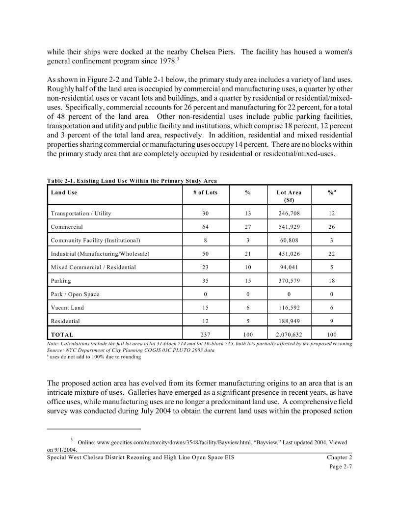
As shown in Figure 2-2 and Table 2-1 below, the primary study area includes a variety of land uses.Roughly half of the land area is occupied by commercial and manufacturing uses, a quarter by othernon-residential uses or vacant lots and buildings, and a quarter by residential or residential/mixed-uses. Specifically, commercial accounts for 26 percent and manufacturing for 22 percent, for a totalof 48 percent of the land area. Other non-residential uses include public parking facilities,transportation and utility and public facility and institutions, which comprise 18 percent, 12 percentand 3 percent of the total land area, respectively. In addition, residential and mixed residentialproperties sharing commercial or manufacturing uses occupy 14 percent. There are no blocks withinthe primary study area that are completely occupied by residential or residential/mixed-uses.
Table 2-1, Existing Land Use Within the Primary Study Area
Land Use # of Lots % Lot Area
(Sf)
% a
Transportation / Utility 30 13 246,708 12
Commercial 64 27 541,929 26
Community Facility (Institutional) 8 3 60,808 3
Industrial (Manufacturing/Wholesale) 50 21 451,026 22
Mixed Commercial / Residential 23 10 94,041 5
Parking 35 15 370,579 18
Park / Open Space 0 0 0 0
Vacant Land 15 6 116,592 6
Residential 12 5 188,949 9
TOTAL 237 100 2,070,632 100
Note: Calculations include the full lot area of lot 31-block 714 and lot 10-block 715, both lots partially affected by the proposed rezoning
Source: NYC Department of City Planning COGIS 03C PLUTO 2003 dataa uses do not add to 100% due to rounding
The proposed action area has evolved from its former manufacturing origins to an area that is anintricate mixture of uses. Galleries have emerged as a significant presence in recent years, as haveoffice uses, while manufacturing uses are no longer a predominant land use. A comprehensive fieldsurvey was conducted during July 2004 to obtain the current land uses within the proposed action


Special West Chelsea District Rezoning and High Line Open Space EIS Chapter 2
Page 2-8
area. The following is a block-by-block analysis of the existing land uses as observed during fieldvisits. As one lot may consist of several buildings, there may be more land uses than tax lots on agiven block.
The block bounded by W. 30th Street, W. 29th Street and Tenth and Eleventh avenues (Block 701)consists of 3 commercial buildings, two of which include gallery space ; 7 9 auto-related uses, whichincludes parking and auto repair facilities; 4 storage facilities, two of which are mini-storage; 2mixed use residential buildings; 1 manufacturing facility; and 5 3 vacant lots/buildings.
The block bounded by W. 29th Street, W. 28th Street and Tenth and Eleventh avenues (Block 700)consists of 3 commercial buildings; 4 galleries; eleven auto-related uses; 1 warehouse/storagefacility; 3 mixed-use residential buildings; 2 building supply yards; one religious facility (with 1 DUon-site); and 1 residential building.
The block bounded by W. 28th Street, W. 27th Street and Tenth and Eleventh avenues (Block 699)consists of 5 commercial buildings; 3 commercial buildings with galleries; 2 auto-related uses; 3industrial/manufacturing facilities; 5 mixed-use residential buildings with ground-floor retail; 2building supply yards; one religious facility; and 1 vacant building.
The block bounded by W. 27th Street, W. 26th Street and Tenth and Eleventh avenues (Block 698)consists of 5 commercial buildings; 1 commercial building with galleries; 3 auto-related uses; 2manufacturing facilities; 2 mixed-use residential buildings with ground-floor retail; 3 galleries; 1residential building; and 2 vacant buildings.
The block bounded by W. 26th Street, W. 25th Street and Tenth and Eleventh avenues (Block 697)consists of 2 commercial buildings; 3 commercial buildings with galleries; 2 auto-related uses; 3galleries; and 2 vacant buildings (one undergoing renovations).
The block bounded by W. 25th Street, W. 24th Street and Tenth and Eleventh avenues (Block 696)consists of 2 commercial buildings; 4 commercial buildings with galleries; 6 auto-related uses; 5galleries; 1 mixed-use building; and 1 vacant building.
The block bounded by W. 24th Street, W. 23rd Street and Tenth and Eleventh avenues (Block 695)consists of 5 commercial buildings; 1 commercial building with galleries; 6 auto-related uses; 1gallery; 5 mixed-use buildings; 5 sites were under construction; 1 manufacturing facility; and 4vacant building/sites.
The block bounded by W. 23rd Street, W. 22nd Street and Tenth and Eleventh avenues (Block 694)consists of 10 commercial buildings; 2 auto-related uses; 3 galleries; 5 mixed-use buildings; 1manufacturing facility; and 1 residential building.
The block bounded by W. 22nd Street, W. 21st Street and Tenth and Eleventh avenues (Block 693)consists of 3 commercial buildings; 1 commercial building with galleries; 1 auto-related use; 1

Special West Chelsea District Rezoning and High Line Open Space EIS Chapter 2
Page 2-9
gallery; 4 mixed-use buildings; 2 warehouses/storage facilities; 2 religious uses; two museums; and2 vacant building/sites.
The block bounded by W. 21st Street, W. 20th Street and Tenth and Eleventh avenues (Block 692)consists of 5 commercial buildings; 3 commercial buildings with galleries; 1 auto-related use; 1gallery; 2 mixed-use buildings; 2 warehouses/storage facilities; 2 commercial/manufacturing uses;and 1 vacant building/site.
The block bounded by W. 20th Street, W. 19th Street and Tenth and Eleventh avenues (Block 691)consists of 2 commercial buildings; 8 auto-related uses; 3 galleries; 2 institutional buildings; and 1vacant building/site.
The block bounded by W. 19th Street, W. 18th Street and Tenth and Eleventh avenues (Block 690)consists of 2 commercial buildings; 2 sites were under construction at the time of the field survey;1 institutional use; 1 mixed-use building; and 1 auto-related use.
The block bounded by W. 18th Street, W. 17th Street and Tenth and Eleventh avenues (Block 689)consists entirely of a private parking lot.
The western half of the block bounded by W. 18th Street, W. 17th Street and Tenth and Ninthavenues (Block 715) consists of 6 8 commercial buildings; 1 gallery; 2 mixed-use buildings; and 1residential building and play area (comprises the eastern limits of the proposed action area); and 1vacant building/site.
The western half of the block bounded by W. 17th Street, W. 16th Street and Tenth and Ninthavenues (Block 714) consists of 4 lots. Several commercial uses, including a garden center; 1commercial building; 2 1 auto-related uses; 1 mixed-use building; and a governmental office arelocated on the western half of the block. Additionally, the area under the High Line (part of lot 1)is vacant and used for auto storage.
The assessment of land uses in the primary study area also includes a description of conditions onthe 25 projected development sites (shown in Figure 1-10), which have been identified in theRWCDS as the sites most likely to be developed as a result of the proposed action by the analysisyear of 2013. The existing conditions of these sites, described below, are also based on the fieldsurveys conducted during July 2004. The rezoning area is a dynamic area in which land uses changeover time. Therefore, the following site descriptions represent the conditions of the area at the timethe survey was conducted. The existing conditions of the lots which would be affected by theproposed action are as follows:
• Site 1: This 27,950 sf site is located at 306-310 Eleventh Avenue (block 701, lot 1), locatedon the corner of W. 29th Street and Eleventh Avenue. The site is zoned M1-5, with apermitted FAR of 5.0. It currently has a 10-story, 229,000 sf building, with a built FAR ofapproximately 8.2. It is partially occupied by Manhattan Ministorage.

Special West Chelsea District Rezoning and High Line Open Space EIS Chapter 2
Page 2-10
• Site 2: This site is comprised of eight tax lots (lots 30, 33, 35, 36, 37, 42, 43, and 45) onblock 701. Lot 30 is a 7,406 sf parcel at 509 W. 29th Street. An existing one-story, 7,406sf warehouse is currently on-site with a built FAR of 5.0. The building has been convertedinto a licensed public parking garage. Lot 33 is a 4,229 sf parcel located at 505 W. 29thStreet. The built FAR is 0.9. It currently has a 1-story, 3,800 sf warehouse building on sitewhich is used as storage space. Lot 35 is a 1,750 sf parcel located at 329 Tenth Avenue witha built FAR of 4.4. It currently has a 5-story, 7,758 sf old-law tenement with 12 dwellingunits and a 1,500 sf restaurant on the ground-floor. Lot 36 is a 1,850 sf vacant parcel locatedat 331 Tenth Avenue with 1,850 sf of parking/auto use. Lot 37 is a 4,933 sf parcel locatedat 333 Tenth Avenue. It is currently a vacant lot. An auto rental company currently uses thelot for vehicle storage. Lot 42 is a 9,875 sf parcel located at 337 Tenth Avenue. It iscurrently used as a licensed public parking lot. Lot 43 is a 6,172 sf parcel located at 502-504W. 30th Street. It currently has a seven-story, 37,500 sf building with a built FAR of 6.1.At the time of the site visit, it was covered in scaffolding and it appeared to be vacant. Lot45 is a 13,578 sf parcel located at 506 W. 30th Street. It currently has a one-story, 13,578sf warehouse with a built FAR of 1.0. The building is used for push cart storage. All ofthese lots are within the M1-5 zone and all have an allowable FAR of 5.0. These six lots areat the eastern-most edge of block 701 with four of the eight lots having frontage on TenthAvenue.
• Site 3: This 24,425 sf site is located at 282-298 Eleventh Avenue (block 700, lot 1). The siteis zoned M1-5, with a permitted FAR of 5.0. It currently has a 2-story, 33,890 38,615 sfbuilding, with a built FAR of approximately 1.7. It is partially occupied by two auto bodyshops and a licensed public parking lot.
• Site 4: This 17,275 sf site is located at 547-559 W. 27th Street (block 699, lot 5), a mid-blockthrough-lot that is 100 feet east of Eleventh Avenue, which runs from W. 27th to W. 28thStreet. It is zoned M1-5, with a permitted FAR of 5.0. It currently has a 6-story, 96,654 sfbuilding, with a built FAR of approximately 5.6. It is occupied by various commercial usesand some of the warehouse has been partially converted to gallery space.
• Site 5: This site is comprised of seven tax lots (lots 22, 23, 24, 25, 26, 27, and 44) on block699. Lot 22 is a 2,468 sf parcel located at 517 W. 27th Street with a built FAR of 1.0. Itcurrently has a 2-story, 2,465 sf warehouse for wholesale industrial machinery andequipment. Lot 23 is a 2,469 sf lot located at 515 W. 27th Street. It is currently occupiedby a 1-story, 2,465 sf commercial building with a built FAR of 1.0. Lot 24 is a 2,469 sf sitelocated at 513 W. 27th Street. This parcel currently has a 2-story, 3,700 sf combinedworkshop /office for a construction company with a built FAR of 1.5. Lot 25 is a 2,469 sfparcel located at 511 W. 27th Street. It is occupied by a 4,450 sf building with a built FARof 1.8. The building contains a gallery and three dwelling units are located above. Lot 26 isa 2,468 sf parcel located at 509 W. 27th Street. It currently has a 7,405 sf building with a4,500 sf metal recycling facility and two residential units on site with a built FAR of 3.0. Lot27 is located at 507 W. 27th Street. The 17,275 sf lot is predominantly open and is being

Special West Chelsea District Rezoning and High Line Open Space EIS Chapter 2
Page 2-11
used as a metal scrap yard. Lot 44 is a 14,800 sf site located at 514-520 W. 28th Street. Itis occupied by an open storage/manufacturing use divided into two portions: a 14,800 sfbuilding partially covers the site and is occupied by gallery space; the remaining lot area isvacant and is used as a private parking lot. All of these tax lots are within the M1-5 zone andall have an allowable FAR of 5.0. This site is 100 feet west of Tenth Avenue. If these sevenlots are combined as projected, the new lot would have 225 foot frontage on both W. 27thand W. 28th streets and would be approximately 197.6 feet deep.
• Site 6: This site is comprised of five tax lots (lots 30, 31, 32, 33, 37) on block 699. Lot 30is a 2,469 sf site located at 503 W. 27th Street with a built FAR of 5.2. It currently has a 6-story, 12,864 sf residential building including a vacant 2,469 sf commercial space locatedon the ground-floor and five residential units above. Lot 31 is a 2,469 sf parcel located at299 Tenth Avenue with a built FAR of 3.8. It currently has a 5-story, 9,370 sf residentialbuilding with 19 dwelling units and a bar located on the ground-floor. Lot 32 is a 2,469 sfparcel located at 301 Tenth Avenue. It has a five-story, 9,370 sf residential building with 19dwelling units and a ground-floor deli. This building has a built FAR of 3.8. Lot 33 is a9,875 sf parcel located at 303-309 Tenth Avenue. There lot is occupied by an one-story,4,937 sf auto repair facility and gas station on-site including open areas and a building whichhas a built FAR of 0.5. Lot 37 is a 2,467 sf parcel located at 311 Tenth Avenue. It has a4,000 sf, four-story residential building with six dwelling units and a 2,467 sf ground-floordeli. This building has a built FAR of 1.6. All of these tax lots are within the M1-5 zone andall have an allowable FAR of 5.0. These five lots are at the eastern-most portion of block699 with all having frontage on Tenth Avenue.
• Site 7: This 34,198 sf site is located at 246-260 Eleventh Avenue (block 698, lot 1). Thissite is zoned M1-5, with a permitted FAR of 5.0. It currently has a 7-story, 154,433 sf officebuilding, with a built FAR of 4.5. The NYC Human Resources Administration has officesat this location.
• Site 8: This site is comprised of five tax lots (lots 32, 35, 37, 40, and 141) on block 698. Lot32 is a 7,075 sf parcel located at 279 Tenth Avenue. There is currently a one-story 1,780 sfautomotive repair facility on-site. It has a built FAR of 0.3. Lot 35 is a 3,160 sf parcellocated at 285 Tenth Avenue. A 4,344 sf commercial building is on-site with a built FARis 1.4. Lot 37 is a 4,937 sf parcel located at 289 Tenth Avenue. It has a one-story 4,933 sfcommercial building with a built FAR of 1.0. Lot 40 is a 4,937 sf parcel at 293 TenthAvenue. It currently has a one-story 5,000 sf art gallery which has a built FAR of 1.0. Lot141 is a 400 sf site located at 502 W. 27th Street. It consists of a single dwelling unit, orapproximately 1,143 sf of residential space within a 3-story structure. The built FAR for thisbuilding is 2.9. These five lots are at the eastern-most portion of block 698 with all lotsexcept lot 141 having frontage along Tenth Avenue.
• Site 9: This site is comprised of two tax lots (lots 27 and 31) on block 697. Lot 27 is 9,875sf property located at 507 W. 25th Street. There is a one-story warehouse on-site which is

Special West Chelsea District Rezoning and High Line Open Space EIS Chapter 2
Page 2-12
used for parking / vehicle storage. Lot 31 is a 19,760 sf parcel located at 259 EleventhAvenue. There is currently a 10-story, 214,780 sf warehouse on-site with commercial,studio, and gallery space inside, which has a built FAR of 10.9. Both of these lots are zonedM1-5, with a permitted FAR of 5.0. Lot 27 and lot 31 are at the eastern portion of block 697along Tenth Avenue. The lots would combine to have 197.6 feet along the avenue and 150feet along W. 25th and W. 26th streets.
• Site 10: This 17,281 sf site is located at 550 W. 25th Street (block 696, lot 58), with frontageon W. 25th Street. The site is zoned M1-5, with a permitted FAR of 5.0. It currently has atwo-story, 34,562 sf building, with a built FAR of 2.0. The building is occupied byauto/vehicle uses currently vacant.
• Site 11: This site is made up of five tax lots (lots 32, 33, 35, 37, and 38) on block 696. Lot32 is a 5,520 sf parcel located at 239 Tenth Avenue. There is an existing 1,904 sf gas stationon-site with a built FAR of 0.3. Lot 33 is a 3,958 sf parcel located at 245 Tenth Avenue.There is an existing 3,958 sf, one-story auto repair shop on-site with a built FAR of 1.0. Lot35 is a 4,950 sf parcel located at 249 Tenth Avenue. There is an existing five-story, 24,490sf auto body shop and parking garage on-site with a built FAR of 5.0. Lot 37 is a 1,463 sfparcel located at 253 Tenth Avenue. There is an existing 3,762 sf mixed-use residentialbuilding on-site with six dwelling units and a built FAR of 2.6. There is 400 sf of ground-floor commercial. Lot 38 is a 1,500 sf parcel located at 255 Tenth Avenue. There is anexisting 1,500 sf, one-story auto audio and design shop on-site with a built FAR of 1.0. Allof these sites are zoned M1-5, with a permitted FAR of 5.0. All five lots have frontage alongTenth Avenue.
• Site 12: This site is comprised of two tax lots (lots 1 and 64) on block 693. Lot 1 is a 12,450sf parcel located at 144-150 Eleventh Avenue. There is currently a 4-story, 38,803 sf vacantwarehouse on-site which has a built FAR of 3.1. Lot 64 is a 9,850 sf parcel located at 154-160 Eleventh Avenue. There is currently a 28,838 sf, 4-story building on-site which has abuilt FAR of 2.9. The Chelsea Art Museum is located in this building. Both of these lotsare zoned M1-5, with a permitted FAR of 5.0. Lots 1 and 64 are at the western edge of block693 along Eleventh Avenue. The lots would combine to have 200 feet along the avenue and100 feet along W. 21st and W. 22nd streets.
• Site 13: This site is comprised of three tax lots (lots 7, 61 and 63) on block 692. Lot 7 is a8,875 sf parcel which is located at 550 W. 21st Street. There is currently a 41,660 sf, 5-storyloft on-site which has a built FAR of 4.7. While art galleries are the predominant use, thereare also professional offices, including a health and social services company, located in thebuilding. Lot 61 is a 5,425 sf parcel located at 550 W. 21st Street. There is currently a 5,425sf, 1-story bar on-site which has a built FAR of 1.0. Lot 63 is a 2,720 sf parcel located at 130Eleventh Avenue. There is currently a 3-story, 4,080 sf warehouse on-site which has a builtFAR of 1.5. The building appeared vacant during field visits conducted in July 2004. Allof these sites are zoned M1-5, with a permitted FAR of 5.0. Lot 7, 61 and lot 63 are at the

Special West Chelsea District Rezoning and High Line Open Space EIS Chapter 2
Page 2-13
western end of block 692 along Eleventh Avenue. The lots would combine to haveapproximately 200 feet along the avenue and approximately 85 feet along both W. 21st andW. 20th streets.
• Site 14: This site is comprised of two tax lots (lots 53 and 57) on block 692. Lot 53 is a4,570 sf site located at 540 W. 21st Street. There is currently a 4,570 sf, one-story retail useon-site which has a built FAR of 1.0. Lot 57 is a 9,200 sf site located parcel at 542 W. 21stStreet. There is currently a one-story, 9,200 sf warehouse on-site which has a built FAR of1.0. The building is currently used as a production studio for digital media. Both of thesesites are zoned M1-5, with a permitted FAR of 5.0. Lots 53 and lot 57 are near the westernend of block 692 along W. 21st Street.
• Site 15: This site is comprised of two tax lots (lots 28 and 30) on block 692. Lot 28 is a9,200 sf parcel located at 521-527 W. 20th Street with an FAR of 1.0. There are currentlyseveral auto repair / service shops on-site. Lot 30 is a 18,400 sf parcel located at 169-183Tenth Avenue. There is currently a one-story, 18,400 sf construction warehouse and shopon-site which has a built FAR of 1.0. Both of these sites are zoned M1-5, with a permittedFAR of 5.0. Lot 30 has frontage along Tenth Avenue and lot 28 is set back from the avenue,but has frontage along W. 20th Street and W. 21st Street. The lots would combine to have150 feet along W. 20th and W. 21st streets and 184 feet along Tenth Avenue.
• Site 16: This 12,525 sf site is located at 100 Eleventh Avenue (block 11, lot 691). This siteis zoned M1-5, with a permitted FAR of 5.0. It currently has no permanent building on siteand as such has a built FAR of 0.0. The entire site is occupied by a public parking lot.
• Site 17: This site is comprised of two tax lots (lots 43 and 50) on block 691. Lot 43 is a16,100 sf parcel located at 532-534 W. 20th Street. There is currently a 61,184 sf, 4-storybuilding on-site which has a built FAR of 3.8. Half of the building is occupied by a publicparking garage and two art galleries comprise the rest of the building. Lot 50 is a 4,600 sfparcel located at 532-534 W. 20th Street. There is currently a 1-story art gallery on-sitewhich has a built FAR of 1.0. Both of these sites are zoned M1-5, with a permitted FAR of5.0. Lot 43 and lot 50 are located mid-block along W. 20th Street. The lots would combineto have 225 feet along W. 20th Street and are 90 feet deep.
• Site 18: This site is comprised of six tax lots (lots 25, 27, 29, 33, 35, and 37) on block 691.Lot 25 is a 5,175 sf parcel which consists of a 5,175 sf truck leasing facility. Lot 27 is a4,600 sf parcel located at 505 W. 19th Street. A 4,600 sf auto storage / private parkingfacility exists on-site. Lot 29 is a 9,200 sf parcel located at 153 Tenth Avenue. There iscurrently a 1-story, 9,200 sf auto repair facility on-site which has a built FAR of 1.0. Lots33, 35, and 37 (each is 4,600 sf) are located at 161 Tenth Avenue, 165 Tenth Avenue, and504 W. 20th Street respectively. The parcels are occupied by a licensed public parking lot.Lots 29, 33 and 35 are at the eastern end of block 691 along Tenth Avenue. The threeremaining lots are all mid-block with frontage along W. 19th Street and W. 20th Street. The

Special West Chelsea District Rezoning and High Line Open Space EIS Chapter 2
Page 2-14
lots would combine to have approximately 200 feet along the avenue and 100 feet each alongW. 19th and W. 20th streets. All of these sites are zoned M1-5, with a permitted FAR of 5.0.
• Site 19: This site is comprised of three tax lots (lots 12, 20 and 54) on block 690. Lot 12 isa 28,850 sf parcel located at 96 Eleventh Avenue; lot 54 is a 520 sf parcel located at 80-92Eleventh Avenue. Both parcels are part of an ongoing construction project. Lot 20 is locatedat a 511-525 W. 18th Street. It is occupied by a 46,000 sf nightclub and is located mid-blockwith 200 feet of frontage along W. 18th Street. The eastern 50 feet of the lot extends fromW. 18th to W. 19th Street, approximately 185 feet. All of these sites are zoned M1-5, witha permitted FAR of 5.0. Lots 12 and 54 are located on the western end of the block alongEleventh Avenue. Lot 20 is a mid-block L-shaped parcel and has frontage along W. 18th andW. 19th streets. The lots would combine to extend approximately 185 feet along EleventhAvenue, approximately 150 feet along W. 19th Street, and 335 feet along W. 18th Street.
• Site 20: This site is comprised of one tax lot (lot 29) on block 690. It is located at a 131Tenth Avenue. The entire 23,000 sf lot is occupied by a licensed public parking lot. The siteis zoned M1-5, with a permitted FAR of 5.0. This lot is located along Tenth Avenue withapproximately 195 feet of frontage on the avenue and 125 feet of frontage along W. 18th andW. 19th streets.
• Site 21: This site is comprised of one tax lot (lot 17) on block 689. It is a 76,425 sf sitelocated at 99-111 Tenth Avenue. The lot is currently a licensed parking lot. This site iszoned M1-5, with a permitted FAR of 5.0. Lot 17 consists of the entire block.
• Site 22: This site is comprised of seven lots (lot 1, 2, 3, 60, 63, and 64, and 65) on block715. Lot 1 is a 2,050 sf parcel located at 118 Tenth Avenue. It has a 2,050 9,719 sf 5-storymixed-use residential building on-site with a built FAR of 4.7. There is a 1,950 sf bar on theground-floor and there are 12 dwelling units above. Lot 2 is a 2,468 sf parcel located at a116 Tenth Avenue. It has a 2,500 sf one-story building on-site with a built FAR of 1.0. Thebuilding is currently vacant although there is ongoing rehabilitation construction. Lot 3 isa 6,883 sf parcel located at a 116 Tenth Avenue. It has a 13,760 sf two-story restaurant on-site with a built FAR of 2.0. Lot 60 is a 5,775 sf parcel located at a 456 W. 18th Street. Ithas a 7,483 sf two-story art gallery on-site with a built FAR of 1.3. Lot 63 is a 1,875 sfparcel located at 128 Tenth Avenue. It has a 1,875 sf one-story restaurant on-site with a builtFAR of 1.0. Lots 64 and 65 are described together. They are a combined has 3,925 sflocated at a 124 Tenth Avenue. The tax lots have It has a 970 sf one-story commercialbuilding on-site with a built FAR of 0.3. The building appeared vacant during site visitsconducted during July 2004. All of these tax lots are zoned M1-5, with a permitted FAR of5.0. They are located along Tenth Avenue with approximately 185 feet of frontage on theavenue, 150 feet of frontage along W. 18th Street and 150 feet of frontage along W. 17thStreet.

Special West Chelsea District Rezoning and High Line Open Space EIS Chapter 2
Page 2-15
• Site 23: This site is comprised of two tax lots (lots 5 and 7) on block 715. Lot 5 is a 4,600sf parcel located at 453 W. 17th Street. The lot has a 4-story, 17,720 sf warehouse on-sitewith a built FAR of 3.9. A variety of different commercial, wholesale and gallery uses arelocated in this building. Lot 7 is a 6,900 sf parcel located at 447 W. 17th Street. The lot hasa two-story, 13,400 sf art studio on-site with a built FAR of 2.0. These parcels are zonedM1-5, with a permitted FAR of 5.0. They are located 100 feet east of Tenth Avenue alongW. 17th Street.
• Site 24: This site is comprised of two tax lots (lots 1 and 63) on block 714. Lot 1 is a 52,900sf parcel located at 96 Tenth Avenue with a built FAR of 0.9. It currently has three 1-storybuildings on-site, for a total of 46,354 sf. Current uses include a nursery, two electricalcontractor's shops /offices, an automotive repair shop, a caterer, a production studio, a theatercompany, and other office uses. Lot 63 is a 2,325 sf site located at 112 Eleventh Avenuewith a built FAR of 4.3. The site currently has a 5-story, 9,905 sf residential building whichhas 16 dwelling units with 1,250 sf of ground-floor retail. Both of these tax lots are withinthe M1-5 zone and have an allowable FAR of 5.0. These two tax lots are on the western halfof block 714, with the eastern border approximately 300 feet east of Tenth Avenue.
• Site 25: Tax lots 14 and 16 make up this projected development site on block 714. Lot 14is a 4,707 sf parcel located at 437 W. 16th Street. There is a 5-story, 27,456 sf commercialbuilding on-site which includes a Department of Veteran’s Affairs office, several galleries,and other office space. This building has a built FAR of 5.8. Lot 16 is a 6,884 sf parcellocated at 431 W. 16th Street. There is a 13,400 sf 2-story commercial building on-site,consisting of an entertainment services company, which has a built FAR of 2.0.
Additionally, 9 mixed-use residential buildings have been constructed in and around West Chelsea(and issued Certificates of Occupancy) between 2000 and 2003. As a result, this area experiencedthe addition of 2,278 new dwelling units. Two of these projects were within the limits of theproposed action area, the 313-unit Tate apartment complex at 527 W. 23rd Street, and the 107-unitMarais.
Secondary Study Area
As described above, the secondary study area includes the area outside of the rezoning area, butwithin a quarter-mile radius, and includes portions of the High Line located outside of the proposedrezoning area as well as the surrounding Midtown, Chelsea, West Village and Clintonneighborhoods. The secondary study area is generally bounded by W. 35th Street on the north,Eighth Avenue on the east, Gansevoort Street on the south, and the Hudson River on the west.
The secondary study area contains a variety of uses; however, residential uses predominate and aregenerally located east of Tenth Avenue in Chelsea. A large concentration of transportation/utilityuses are located in the northern portion of the secondary study area, north of W. 30th Street. Otherland uses in the secondary area include mixed residential/industrial, commercial retail and office,

Special West Chelsea District Rezoning and High Line Open Space EIS Chapter 2
Page 2-16
public facilities and institutions, parking facilities, open space and outdoor recreation, and vacantland.
Directly north of the rezoning area, within the proposed Special Hudson Yards District,transportation and utility uses predominate, including the Long Island Rail Road John D. CaemmererWest Side Yard in the area bounded by Tenth and Twelfth Avenues between W. 30th and W. 33rdStreets. The Lincoln Tunnel ramps and its associated roadways are located between Ninth and TenthAvenues. Other uses include the Jacob K. Javits Convention Center, located north of W. 34th Streetbetween Eleventh and Twelfth Avenues, the James A. Farley US Post Office, and several parkingfacilities.
To the east, the predominant land use is residential, including walk-up multifamily dwellings andhigh-rise elevator apartment buildings. The latter includes the Chelsea/Elliot Houses and the RobertFulton Houses, New York City Housing Authority (NYCHA) developments, as well as the PennStation South Houses, a limited-equity co-operative apartment complex, and London TerraceApartments, a market-rate co-operative complex. There are also several public facilities andinstitutions, among these are the USPS Morgan General Mail Facility, General Theological Seminaryand Church (covering the entire block between W. 20th and W. 21st Streets), several churches, andseveral schools. The area east of Tenth Avenue is also occupied by commercial uses including retail,hotels, bars and nightclubs. A recent addition is the Maritime Hotel, on W. 16th Street and NinthAvenue. The site of this recent commercial conversion was formerly occupied by a maritime unionhall. Chelsea Park is located on the full-block between Ninth and Tenth Avenues, south of W. 28thStreet, and features a mix of passive and active recreation.
South of West Chelsea, the Meat Packing District (actually part of the West Village), contains a mixof residential, commercial and manufacturing and warehouse uses. As its name implies, the MeatPacking District is known for the historic presence of wholesale meat distributors andslaughterhouses. The few remaining uses are located south of W. 14th Street and west ofWashington Street, and, more generally, south of the secondary study area. The predominant landuses south of W. 14th Street include mixed residential and retail buildings located along W. 14thStreet, east of Ninth Avenue. The area bounded by W. 14th, Hudson, Washington and GansevoortStreets contains a mix of commercial and residential uses, including hotels, boutiques, bars,restaurants and apartment buildings. The 187-room Gansevoort Hotel, at Ninth Avenue and W. 13thStreet, opened in the spring of 2004. This area is zoned entirely M1-5, which allows for a broadrange of commercial uses and light manufacturing, but does not allow residential. Most of the areais located within the boundaries of the Gansevoort Market Historic District, designated in 2003.
In contrast to the remainder of the Gansevoort Market area, the blocks to the west of Washingtonstreet, through which the High Line runs, have not received the same amount of reinvestment andcontain vacant buildings and lots. There are plans however for the construction of an as-of-righthotel along the west side of Washington Street and Little W. 12th and W. 13th Streets. Preliminaryplans for the hotel indicate that a reused High Line would become an integral part of the hotel’sdesign.

Special West Chelsea District Rezoning and High Line Open Space EIS Chapter 2
Page 2-17
To the west, the blocks between Eleventh and Twelfth Avenues are occupied by commercial,industrial, and transportation/utility uses, with the exception of the Chelsea Waterside Park at W.23rd Street. West of Route 9A, along the waterfront is Hudson River Park, which is currently underdevelopment, including several piers which will be redeveloped for park use, and the Chelsea PiersSports and Entertainment Complex, a privately owned facility.
Future Without the Proposed Action (No-Action)
In the future without the proposed action, the existing zoning controls would remain in place. It isexpected that the West Chelsea area would experience nominal growth in light manufacturing uses,continued commercial conversions in warehouses and loft buildings and the High Line would remainin its current unused state. Expected growth by 2013 would include commercial conversions,including the continued development of gallery and office space, as well as hotel development.Residential growth is expected to occur along W. 23rd and W. 24th Streets.
Primary Study Area
In the future without the proposed action, it is expected that the current land use trends and generaldevelopment patterns would continue. These trends are characterized by an overall decline inindustrial and manufacturing uses, a continued shift to commercial development, and limitedresidential growth due to the prohibitive M1-5 zoning mapped over much of the primary study area.
The continued underutilization of land in the future without the proposed action is primarily due tothe existing zoning, which permits commercial and manufacturing uses but prohibits residential use.As a result of the existing M1-5 zoning, the predominant residential land uses found to the east ofTenth Avenue in Chelsea, would not penetrate the West Chelsea area. Absent the proposed action,residential uses would be limited to the area along W. 23rd and W. 24th Streets. It is expected thata mixed-use residential development, with ground floor retail would be constructed and occupiedon Tenth Avenue, between W. 23rd and W. 24th Streets. The building would contain approximately51,000 sf of residential space (16 24 DUs) and 2,000 sf of ground floor retail. Additionally, twosmaller as-of-right residential developments, that are not considered qualitatively, will add a totalof 22 17 new residential units along the 23rd Street corridor. In addition, a 337-DU apartmentbuilding at 555 W. 23rd Street, located on Potential Development Site 48, is under construction.
As-of-right commercial development, in the form of new construction and conversions andenlargements of existing warehouse and loft buildings would likely persist, as opportunities forresidential uses would generally not be provided in the primary study area. The existing trend ofcommercial conversions is expected to continue in the future without the proposed action, as retailuses are expected to locate in the midblock area from W. 20th Street to the north side of W. 22ndStreet, as well as the midblocks between W. 24th and W. 27th Streets. Moreover, it is anticipatedthat the High Line would remain inaccessible to the public in the future without the proposed action,and no new open space would be provided within the primary study area.
Special West Chelsea District Rezoning and High Line Open Space EIS Chapter 2
Page 2-18
There are two known as-of-right commercial developments expected to occur in the proposed actionarea which are not located on projected or potential development sites. At 520 W. 27th Street (Block698, Lot 49), a new commercial development with 48,000 sf is expected to replace the existingcommercial/industrial uses on the site. This building is to include 24,000 sf of art gallery/retailspace, 12,000 sf of office space, and 12,000 sf of other commercial/art studios. Another newdevelopment, currently under construction, is expected at 543 W. 25th Street (Block 697, Lot 10),a new building with approximately 100,000 sf of art gallery space. This is to include 50,000 sf ofart gallery/retail space, 25,000 sf of office space, and 25,000 sf of other commercial/art studios.
In addition to the mixed-use residential building developments described above, as summarized inChapter 1, "Project Description," additional development is expected to occur as-of-right in thefuture without the proposed action on 9 of the 25 projected development sites. These sites have beenidentified below and are shown in Table 2-2.
Table 2-2, Projected Developments in the Future Without the Proposed Action
Projected Site # Block / Lot Retail FA Office FA Hotel FA FAR
1 701 / 1 25,155 201,050 0 8.2*
2 701 / 43 5,555 31,328 0 6.1*
4 699 / 5 0 94,927 0 5.6*
9 697 / 31 37,544 175,260 0 10.9*
12 693 / 1 18,779 18,779 0 5.0
14 692 / 57, 53 67,473 0 0 5.0
18 691 / 29, 33, 35, 25, 27, 37 29,498 0 131,100 5.0
19 690 / 12, 54 5,000 160,000 0 5.0
22 715 / 2 2,500 0 0 5.0
Total 191,504 681,344 131,100
* Built FAR
The following conditions are expected on the projected development sites in the future without theproposed action:
• Site 1: The existing 10-story warehouse on Block 701, Lot 1 would be converted to 25,155sf of retail and 201,050 sf of office uses in the future without the proposed action.
• Site 2: This site is comprised of 8 lots on Block 701. Only lot 43 would change in the futurewithout the proposed action. The vacant building would be converted to 5,555 sf of retail and31,328 sf of office.

Special West Chelsea District Rezoning and High Line Open Space EIS Chapter 2
Page 2-19
• Site 4: The existing building would be converted to 94,927 sf of offices under No-Actionconditions.
• Site 9: The existing storage facility on lot 31 would be converted to 37,544 sf of retail and175,260 sf of office space under No-Action conditions. No changes are projected for lot 27under No-Action conditions.
• Site 12: The existing building on lot 1 would be converted to 18,779 sf of retail and 18,779sf of office space. No changes are projected for lot 64 under No-Action conditions.
• Site 14: The existing buildings on Block 692, Lots 53 and 57, would be expanded under No-Action conditions. Approximately 35,880 sf would be added to the 9,200 sf building on lot57 and approximately 17,823 sf would be added to the existing 4,570 sf building on lot 53for the commercial retail expansion of the existing Eyebeam Atelier Gallery.
• Site 18: The existing buildings on lots 29, 33, 35, 25, 27, and 37 would be removed and thelots would be assembled and redeveloped with a 131,100 sf hotel, including 29,498 sf ofretail on the ground floor.
• Site 19: This site would contain approximately 160,000 sf of office space, 5,000 sf of retail,and a 23,000 sf of accessory parking on lots 12 and 54. Community facility space also maybe included with the final building program, though no square footage is currently known.The building would serve as the headquarters of the InterActiveCorp (IAC) and is currentlyunder construction. No changes are projected on lot 20.
• Site 22: No changes are projected on lots 1, 3, 60, 63, or 64, or 65 under No-Actionconditions. The 2,500 sf building on lot 2 would be converted from community facility useto retail under No-Action conditions.
No changes are expected to occur on the remaining projected development sites (sites 3, 5-8, 10, 11,13, 15-17, 20, 21, 23-25).
The sites listed above correspond to Table 2-2, and the location of these sites are presented in Figure2-3, No-Action Conditions on Projected Development Sites. These sites represent development inthe future without the proposed action under current zoning regulations.
Recent trends in the area have been towards residential development along the 23rd Street corridor.On a wider scale, the overall pattern for the area has been one of adaptively reusing the formermanufacturing buildings for gallery and office space. The trends have been moving steadily awayfrom manufacturing and industrial uses and towards commercial and residential uses. Continuingrecent trends, population and housing levels in the primary study area are expected to risesubstantially through 2013. Four new residential developments would be introduced within the heartof the primary study area, between W. 23rd and W. 24th streets. These developments would belocated within the MX district along the 23rd Street corridor, and as such, could occur as-of-right

Figure 2-3No-Action Conditions on the Projected Development Sites
SPECIAL WEST CHELSEA DISTRICT REZONING AND HIGH LINE OPEN SPACE EIS
LEGEND
Rezoning Area
Projected No-Action Development Site
Special West Chelsea District Rezoning and High Line Open Space EIS Chapter 2
Page 2-20
in the future without the proposed action. The first development would be located on a mid-blockparcel with frontages on the north side of W. 23rd Street and on the south side of W. 24th Street; thesecond development would be located on the west side of Tenth Avenue between W. 23rd and W.24th streets. The remaining two smaller developments would be located on the north side of W.23rd Street. In total, development in the future without the proposed action would create 376 378market-rate housing units in the primary study area.
As discussed in Chapter 1, “Project Description,” if development does not occur on the projecteddevelopment sites, the same overall amount of development could occur instead on some or all ofthe potential development sites. In the future without the proposed action, such development couldoccur on nine 11 of the 29 28 sites and no development is likely on 18 17 of the potentialdevelopment sites. This potential development could occur as-of-right, pursuant to existing zoningin the future without the proposed action. As discussed in Chapter 1, “Project Description,”Potential Development Sites 46 through 53 and a portion of Potential Development Site 42, currentlylocated in the MX-3 Special Mixed-Use District, mapped as part of the Chelsea Rezoning (CEQRNo. 99DCP030M), contain noise attenuation requirements mandated by the MX-3 district, pursuantto ZR Section 123-32. As part of the proposed action, the MX-3 district would be eliminated andmapped with underlying contextual C6-2A and C6-3A zoning districts. In order to ensure that thenoise attenuation requirements continue to apply to these sites once the MX-3 district is eliminated,these sites have been included in both the future with and future without the proposed action. Noincremental development is expected on these sites as a result of the proposed action.
Potential No-Action developments within the primary study area include:
• Site 29: The existing buildings on Block 701, lots 24 and 28 could be converted to officespace with ground floor retail. The potential development on lot 24 could include 8,888 sfof ground floor retail and 45,125 sf of office space. Lot 28 could be converted to 4,443 sf ofground floor retail with approximately 27,301 sf of office space above.
• Site 40: The 108,081 sf general commercial space in this loft building on Block 696, Lot 65could be converted to 8,888 sf of retail and 98,206 sf of office space under no-actionconditions.
• Site 42: A portion of this site (Block 694, part of lot 39), presently occupied by 3,285 sf ofauto-related uses would contain 104 DUs and 9,000 sf of retail under No-Action conditions.
• Site 46: The 90,509 sf of storage/manufacturing space on Block 694 (lots 58, 60, 61, and 65)could potentially be redeveloped into 335 dwelling units (DUs) and 39,825 sf of ground floorretail.
• Site 47: The 24,098 sf of commercial floor area on Block 695 (lots 1, 3, and 4) couldpotentially be redeveloped into 76 DUs and 9,540 sf of ground floor retail.

Special West Chelsea District Rezoning and High Line Open Space EIS Chapter 2
Page 2-21
• Site 48: The 32,094 sf of commercial vacant floor area on Block 695 (lots 7, 12, and 57)would be replaced with a 337-unit apartment building, including 40,593 sf of retail. Asnoted above, this development is currently under construction.
• Site 49: The 14,440 sf of storage/manufacturing floor area on Block 695 (lot 44) couldpotentially be redeveloped into 43 DUs and 7,231 sf.
• Site 50: The 21,907 sf of storage/manufacturing floor area on Block 695 (lot 47) couldpotentially be redeveloped into 43 DUs and 7,231 sf.
• Site 51: The 21,818 sf of storage/manufacturing floor area on Block 695 (lot 59) couldpotentially be redeveloped into 43 DUs and 7,231 sf.
• Site 52: The 7,882 sf of storage/manufacturing and vacant floor area on Block 695 (lots 67,68, 69, and 70) could potentially be redeveloped into 57 DUs and 6,661 sf of ground floorretail.
• Site 53: The 127,573 sf of existing storage/manufacturing floor area located on Block 694(lot 47) could potentially be redeveloped into 75 DUs and 12,886 sf of ground floor retail.
Secondary Study Area
There are several other actions and development projects expected to occur in the surroundingsecondary study area by the 2013 analysis year. Table 2-3 lists these developments and Figure 2-4,No-Action Developments in the Secondary Study Area, depicts their location. As shown in Table2-3, the anticipated development in the secondary study area in the future without the proposedaction is expected to consist of a total of 1,683,291sf of residential floor area; 237,779 565,557 sfof retail space (along with 26,674 sf of restaurant space on Pier 57); 5,449,065 5,914,065 sf of officespace; 477,000 727,000 sf of hotel space; 210,000 260,783 sf of convention floor area and 75,000seats in a multi-purpose sports and entertainment facility; 519,356 563,241 sf of community facilityand institutional space; a 468,000 sf of auto use (housing an NYPD tow pound, NYC Departmentof Sanitation garage, and/or a bus garage); 111,203 sf of ballroom, dance studio, and art studio space;and a 24-slip marina.
Given the strong demand for housing in Manhattan, residentially zoned areas surrounding theprimary study area may experience increased pressure for residential development in the futurewithout the proposed action that would otherwise be accommodated in the primary study area withthe proposed action.
In the future without the proposed action, there are two three major land use changes expected tooccur in the secondary study area by 2013: development generated by the proposed recently adoptedrezoning of the Hudson Yards area directly to the north; and the redevelopment of Pier 57 to thesouthwest of the primary study area; and the reuse of the General Post Office (Farley Building) withan expanded Pennsylvania Station and commercial space.


Sp
ecia
l W
est
Ch
else
a D
istr
ict
Rez
on
ing
an
d H
igh
Lin
e O
pen
Sp
ace
EIS
Ch
apte
r 2
Pa
ge
2-2
2
TA
BL
E 2
-3,
Pla
nn
ed
No
-Ac
tio
n D
ev
elo
pm
en
ts i
n t
he
Se
co
nd
ary
Ar
ea
(1
/4-M
ile
Ra
diu
s o
f A
cti
on
Ar
ea
) N
otes
are
on
the
fol
low
ing
page
Map ID
Blo
ck/
Lot
Loc
atio
nB
uil
dY
ear
Res
. F
A /
# D
UR
etai
l /
Gal
lery
FA
Res
tau
-ra
nt
FA
Bal
lroo
m /
Art
/Dan
ceS
tud
io F
A
Off
ice
FA
Hot
el F
AC
on
ven
tio
n /
Sp
orts
FA
Com
mF
acil
ity
/In
st F
A
Ma
rin
a(S
lip
s)P
ark
ing
/V
ehic
leS
tora
ge
Em
erg-
ency
M
gt
Tra
nsp
ort
/ U
tili
tyT
otal
sf
A72
8 /
324
06
W 3
1 S
t 20
050
sf /
0 D
U0
00
00
031
9,35
60
00
031
9,35
6
B74
0 /
123
43
W 1
6 S
t20
0519
,369
sf
/23
DU
00
00
00
00
00
019
,369
C67
5 /
All
Bo
un
d b
y W
29
&
W 3
0 S
t an
d 1
1 &
12
Av
2010
0 sf
/ 0
DU
00
00
00
00
468,
000*
*0
046
8,00
0
D67
6 /
All
Bou
nd
by
W 3
0 &
W 3
3 S
t an
d 1
1th
& 1
2 A
v20
100
sf
/ 0
DU
50,0
000
00
021
0,00
0 sf
&7
5,0
00
sea
ts0
00
00
260,
000
&75
,000
sea
ts
E70
2 /
1T
he
sou
ther
n h
alf
of
the
blo
ck b
oun
d b
y W
30
&W
33 S
t an
d 1
0 &
11
Av
(HY
ID
# 2)
***
2013
0
sf /
0 D
U25
,000
0
0
1,50
7,65
0 0
0
200,
000
0
0
0
0***
***
1,
732,
650
F
729
/1
368
10th
Av
(HY
ID
# 31
)***
2013
826,
606
sf/
827
DU
00
037
7,70
8**
***
477,
000
00
00
00
1,68
1,31
4
G
729
/60
424
W 3
3 S
t, S
W C
orn
er o
f9
Av
& W
33
St
(HY
ID
# 32
)***
2013
322,
916
sf/
323
DU
24,2
190
01,
364,
724
00
00
00
01,
711,
859
H
729
/50
361
9th
Av
(HY
ID
# 33
)***
2010
514,
400
sf/
514
DU
38,5
800
02,
173,
983
00
00
00
128,
600
2,85
5,56
3
I
Pie
r57
*A
- T
he
Leo
nar
do
at P
ier
5720
070
sf /
0 D
U80
,338
26,6
7498
,703
25,0
000
50,7
8343
,885
24
00
032
5,43
3 &
24
sli
ps
B -
Ch
else
a P
iers
2007
0 sf
/ 0
DU
100,
000
NA
****
40,0
000
013
0,00
015
,000
200
050
,000
16,0
0035
1,00
0 &
20
0 s
lips
J64
6 /
104
50
W 1
4 S
t20
080
sf /
0 D
U10
,000
00
40,0
000
00
00
00
50,0
00
K64
6 /
17,1
84
40
W 1
4 S
t20
070
sf /
0 D
U12
,500
012
,500
00
00
00
00
25,0
00
L64
5 /
1143
8-45
0 W
13
St,
ak
a 85
6W
ash
ing
ton
St
2008
0 sf
/0
DU
00
00
250,
000
00
00
00
250,
000
M75
5 /
40P
enn
Sta
tion
Red
evel
opm
ent,
Moy
nih
anS
tati
on
at
Far
ley
Bu
ild
ing
2010
0 sf
/0
DU
325,
000
00
425,
000
00
00
00
085
0,00
0
Tot
al1,
683,
291s
f/
1,68
7 D
U56
5,55
726
,674
111,
203
5,91
4,06
572
7,00
026
0,78
3 sf
&7
5,0
00
sea
ts56
3,24
12
4 S
lip
s46
8,00
050
,000
128,
600

Special West Chelsea District Rezoning and High Line Open Space EIS Chapter 2
Page 2-23
Table 2-3, Notes to Table on Preceding Page
* All numbers for Pier 57 are preliminary.** This site is expected to be a NYPD Tow Pound, NYC Dept of Sanitation Garage, and/or a bus depot with accommodation for openspace/park above. *** The HY ID # corresponds with the map ID that is used in the Hudson Yards FGEIS, November 2004.**** The proposed square footage of restaurant FA is not known at this time.***** Approximately 1,399,264 sf of existing office space will remain. The 377,708 sf in the table above represents an incrementalincrease in office space on-site.****** The 570,000 sf rail yard will remain on-site, below the projected development. However, as this is an existing use, it is notconsidered in the above table.
--------------------------------------------------------------------------------------------------------------------
As described below, the Hudson Yards rezoning would is projected to result in several significantchanges to the secondary study area by the 2013 analysis year. In January 2005 the City has proposedadopted a comprehensive rezoning initiative for the far west side of Manhattan, generallyencompassing the area bounded by W. 43rd Street on the north, Hudson River Park to the west, W.28th and W. 30th Street and W. 31st Street on the south (southern boundary varies), and Seventh andEighth Avenues on the east (eastern boundary varies). The proposed new zoning is intended toensure the future growth of the City through redevelopment of the Hudson Yards area, providetransit services to support such development, and maintain or improve environmental conditions aspart of the overall development plan. The main components of the project which will affect land usein the future without the proposed action include:
• Zoning map and zoning text amendments to the New York City Zoning Resolution andrelated land use actions to permit development of the Hudson Yards area as a mixed-usecommunity with new commercial and residential space, and a substantial amount of newopen space.
• Construction and operation of an extension of the No. 7 Subway Line (No. 7 SubwayExtension) to serve Hudson Yards; and
• Other public actions intended to complement such development and serve the City as awhole, including:
- Expansion, renovation, and modernization of the Convention Center, includingconstruction of approximately one million square feet of new exhibition space plusadditional space for meeting rooms, banquet halls, and other facilities, anddevelopment of a new hotel with up to approximately 1,500 rooms;
- A new Multi-Use Sports, Exhibition, and Entertainment Facility (Multi-Use Facility)with approximately 30,000 square feet of permanent meeting room space and thecapability to convert into a number of different uses and configurations, includinga stadium configuration, with a seating capacity of approximately 75,000, an

Special West Chelsea District Rezoning and High Line Open Space EIS Chapter 2
Page 2-24
exhibition floor space, or a plenary hall configuration that provides a maximumseating capacity of approximately 40,000; and
- Accommodations for other facilities, new or replacement transportation facilities forpedestrian movement, vehicle storage, and other public purposes.
Each of these components would are expected to contribute to the creation of a vital, 24-hour mixed-use commercial and residential community directly to the north of the primary study area.
In September 2003, the Hudson River Park Trust (the Trust) issued a Request for Expressions ofInterest (RFEI) for Pier 57. By January 2004, the Trust received eight responses to the RFEI. TheTrust has recently selected two proposals which most substantially complied with the RFEI for finalconsideration and will choose a final project by December 2004. The scenarios analyzed herein arepreliminary estimates which were used for the purposes of the RFEI for the Trust. As no finaldevelopment program has been selected for Pier 57, both of the final proposals were considered foranalysis purposes throughout this EIS. The actual floor area of each use would likely change in thefinal building program as compared to the numbers analyzed in Table 2-3. As shown in Table 2-3,both of the Pier 57 redevelopment plans would introduce a wide variety of retail, cultural,recreational and dining facilities to the southwest of the proposed action area.
In connection with the ongoing development of Hudson River Park, the Hudson River Park Trustdesignated a developer to redevelop Pier 57, located at the foot of W. 15th Street. The preliminaryprogram for scenario A, “the Leonardo at Pier 57,” as selected includes plans for 26,674 sf ofrestaurant space; 80,338 sf of retail floor area; 98,703 sf of ballroom floor area; 25,000 sf of officespace; 50,783 sf of health club facilities; 43,885 sf of cultural facilities; and a 24-slip marina. Publicuses are to include an esplanade and an approximately 46,000 sf rooftop publicly accessible openspace. Full build-out of Pier 57 is expected to occur by fall 2007. This project, located adjacent toChelsea Piers, would likely increase the amount of activity in West Chelsea and add to the appealof the overall area.
The program for scenario B, “Chelsea Piers,” includes plans for approximately 100,000 sf of artgallery space and retail; approximately 40,000 sf of dance studio space; approximately 130,000 sfof tennis and swimming facilities; approximately 15,000 sf for a creative arts center; anapproximately 200 slip marina, which may also include large vessel dockage for historic ships;approximately 50,000 sf of emergency management facility space located in the caisson basement;and approximately 16,000 sf of electrical generation facilities, also located in the caisson basement.
While the floor area allocated to the various uses in the final Pier 57 redevelopment plan wouldlikely differ from the numbers that are discussed above, the diverse mix of future uses would likelyremain the same. Both development The proposals would feature includes a publicly accessiblewaterfront and would introduce many new cultural, educational, and recreational amenities to thearea.

Special West Chelsea District Rezoning and High Line Open Space EIS Chapter 2
Page 2-25
The Pennsylvania Station Redevelopment Project involves the adaptive reuse of the James A. FarleyUS General Post Office. The site is located on the superblock bounded by W. 33rd and W. 31ststreets, Eighth and Ninth avenues and the trains tracks and platforms used by the Long Island Rail,Road, NJ Transit, and Amtrak are located beneath the building. Approximately 300,000 sf of the1.4 million sf building will be programmed for train operations, providing increased passengercirculation and waiting areas and fuller use of existing platforms in a state-of-the-art, high qualitygateway for the City, similar to the original Pennsylvania Station which was replaced by the currentbasement level facility. Penn Station is the busiest transportation terminal in the nation handlingover a half-million passengers daily.
The draft public scoping document for the Farley Post Office/Moynihan Station RedevelopmentProject (January 2005) calls for approximately 850,000 sf of commercial development by 2010,consisting of 750,000 sf of commercial space and 100,000 sf of transit-oriented retail space. Foranalysis in this FEIS, it is assumed that the first phase of this project involving the existing buildingis expected to be implemented by 2010. The program for this project, which was tentative at thetime the FEIS was prepared, consists of approximately 162,000 sf of local retail space and 163,000sf of destination retail, for a total of 325,000 sf of retail space, and 425,000 sf of office space. Thisprogram may be revised subsequent to the preparation of the FEIS. Some existing US Postal Serviceoperations are expected to remain at the site, including the retail lobby. A later phase involving newconstruction on the site is not expected to be implemented until after 2013 and therefore is notconsidered in this FEIS. The project is also referred to as Moynihan Station.
Although outside the secondary study area, the recently approved Ladies’ Mile Rezoning, locatedeast of the proposed Special West Chelsea District, rezoned 5 ½ blocks in the Flatiron neighborhood.The area is located on the midblocks between Fifth and Sixth avenues, from the centerline between16th and 17th streets to the south, to 22nd Street on the north. Except for two properties in itssouthwest corner, the entire Rezoning Area is located within the Ladies’ Mile Historic District. Therezoning is intended to: update the zoning to reflect the current mixed-use character of the area;allow for residential development on underutilized lots; and to strengthen and preserve the area’sbuilt character. The new C6-4A zoning would reflect the evolution of the area from one dominatedby manufacturing uses to one with a wide mix of uses, including a significant residential presence.
The new zoning would allow for much-needed new housing construction, including the potential foraffordable housing, in an appropriate building form that respects the existing building context of thearea. Specifically, the proposed rezoning is estimated to facilitate the development of approximately900 new apartments on six underutilized sites over the next ten years. These buildings would putcurrently underutilized land into productive use and would make a meaningful contribution to theCity’s efforts to address its affordable housing shortage.
As the Ladies’ Mile rezoning is outside the study area, the individual developments that will resultfrom the rezoning are not considered quantitatively herein. Likewise, the proposed action would notresult in any adverse impacts on the Ladies’ Mile rezoning area, nor would Ladies’ Mile have anyadverse impacts on the study area.

Special West Chelsea District Rezoning and High Line Open Space EIS Chapter 2
Page 2-26
Future With the Proposed Action
Primary Study Area
The proposed action would not result in significant adverse land use impacts in the primary studyarea. By 2013, much of the primary study area would be occupied by mixed-use residentialbuildings with retail generally located on the ground floor. The elimination of most of the existingM1-5 district and mapping of the proposed Special West Chelsea District, with its underlying C6-2,C6-3, and C6-4 regulations, would enable existing manufacturing, storage and auto-related uses toremain, but would also encourage retail and higher density residential development. It is expectedthat this development would occur along the west side of Tenth Avenue, the east side of EleventhAvenue, the midblocks between W. 18th and W. 20th Streets and W. 27th and W. 30th Streets andthe western portions of the blocks bounded by W. 16th and W. 18th Streets, east of Tenth Avenue.The existing trend of commercial conversions is expected to continue in the future with the proposedaction, as commercial retail uses, including galleries, are expected to locate in the midblock areafrom W. 20th Street to the north side of W. 22nd Street, as well as the midblocks between W. 24thand W. 27th Streets. Mixed-use residential development with retail and light manufacturing wouldoccupy the area along W. 23rd Street and portions of Tenth and Eleventh Avenues between W. 22ndand W. 24th Streets in both the future with and future without the proposed action.
If all of the 25 projected development sites were to be redeveloped, the following would bedeveloped by 2013: a total of approximately 4,809 DUs, including 468,677 sf of residentialconversions; 564,254 574,128 sf of retail floor area; 160,000 sf of office floor area; 76,425 sf ofaccessory parking for an off-site government use; and 227,564 sf of community facility use.
Compared to the No-Action condition, the proposed action is expected to generate a net change inuses of approximately 4,708 DUs, 219,507 146,411 sf of local retail space, 73,169 48,804 sf ofdestination retail space (together local and destination retail include 292,676 195,215 sf of new retailspace), -816,847 -796,947 sf of office space, -131,100 sf of hotel floor area, -40,809 -74,818 sf ofstorage and manufacturing floor area, -318,580 -225,940 sf of parking/auto floor area, 198,726 sfof commercial facility floor area, and -25,064 -4,080 sf of vacant floor area.
The locations of the projected and potential development sites are shown in Figure 1-10. Site dataare presented below for the future with the proposed action, followed by Table 2-4 which shows theincremental net change in development between the No-Action and With-Action conditions.
The following development is anticipated to occur in the future with the proposed action:
• Site 1: The existing 10-story warehouse would be converted to 25,155 sf of retail and201,050 sf of office space in the future without the proposed action. With-Action conditionswould include conversion to 201 DUs with 25,155 sf of ground floor retail. The futurezoning designation would be C6-4, with a maximum FAR of 10.0.

Special West Chelsea District Rezoning and High Line Open Space EIS Chapter 2
Page 2-27
• Site 2: Under No-Action conditions, this site would consist of 12 DUs, 7,055 sf of retail,31,328 sf of office space, 3,800 17,378 sf of storage and manufacturing space, 9,875 and24,064 sf of parking/auto use and 20,984 sf of vacant floor area. Under With-Actionconditions, approximately 354 DUs, 30,082 sf of new retail FA, and an additional 18,886 sfof retail conversion space would be constructed on this site utilizing the High Line transferzone and additional air rights transfers.
• Site 3: Under No-Action conditions, the site would remain a 33,890 sf parking/auto facility.Under With-Action conditions, approximately 291 DUs and 21,983 sf of ground floor retailwould be constructed. The western portion of lot 1 would be zoned C6-4 with a 12.0 FAR,while the eastern portion of the lot would be zoned C6-3 with a maximum FAR of 7.5.
• Site 4: The existing general commercial building would be converted to 94,927 sf of officespace under No-Action conditions. Under With-Action conditions, Site 4 would be withinthe C6-3 zone and would have an FAR of 7.5. The existing building would be converted toresidential use and expanded. Approximately 118 DUs would result, including 79,379 sf ofresidential conversion and 15,548 sf of ground floor retail.
• Site 5: Under existing conditions, the site has 8,634 sf of commercial space and 39,040 sf ofstorage/manufacturing space. Under No-Action conditions, Site 5 would have 5 DUs, 2,469sf of retail space, 6,165 sf of office space and 37,009 39,040 sf of storage/manufacturingspace. Approximately 283 DUs and 39,976 sf of ground floor retail would result from theproposed action. All seven of the lots that comprise this projected development site wouldbe within the proposed C6-3 zone. Lots 44, 22, 23, 24 and the western portion of lot 27would have a maximum FAR of 7.5, while lots 25, 26, and the eastern portion of lot 27would have a base FAR of 5.0.
• Site 6: Under existing conditions, the site has 9,874 sf of retail, 4,937 9,875 sf ofparking/auto use and 49 DUs. Under No-Action conditions, the site would remainunchanged. Approximately 159 DUs and 18,763 28,637 sf of ground floor retail areexpected for this projected development site under With-Action conditions. All of the lots(29, 31, 32, 33 and 37) would be within the proposed C6-3 zoning designation with amaximum FAR of 7.5.
• Site 7: Under existing conditions, the site has 154,433 sf of commercial space. Under No-Action conditions, the site would be office uses. Approximately 240 DUs (including 120,235sf of residential conversion) and 30,778 sf of ground floor retail would be constructed on lot1 under With-Action conditions. The site would be in the C6-3 zone with a maximum FARof 7.5 under With-Action conditions.
• Site 8: Under existing conditions, the site has 14,277 sf of commercial space, 1,780 sf ofparking/auto space, and 1 DU. Under No-Action conditions, Site 8 would have 4,933 9,933sf of retail space, 9,344 4,344 sf of office floor area, 1,780 sf of parking/auto space, and 1DU. Approximately 133 DUs are projected and 38,967 sf of retail are expected for the first

Special West Chelsea District Rezoning and High Line Open Space EIS Chapter 2
Page 2-28
two floors in the future with the proposed action. All five lots would be within the C6-3zone with a maximum FAR of 7.5.
• Site 9: Under existing conditions, the site has 214,780 sf of storage/manufacturing space and9,875 sf of parking/auto space. Under No-Action conditions, Site 9 would have 37,544 sfof retail space, 175,260 sf of office floor area, and 9,875 sf of parking/auto space.Approximately 175 DUs and 8,888 sf of retail would be constructed under With-Actionconditions. Both lots would be within the C6-3 zone. Lot 31 would have a maximum FARof 7.5 while lot 27 would have a base FAR of 5.0.
• Site 10: Under existing conditions, the site has 34,562 sf of parking/auto space. Under No-Action conditions, the site would remain unchanged. A 110,598 sf museum would beconstructed on lot 58 under With-Action conditions. This site would remain in the M1-5zoning district with an allowable community facility FAR of 6.5.
• Site 11: Under existing conditions, the site has 1,900 400 sf of commercial space, 30,35231,852 sf of parking/auto space, and 6 DUs. Under No-Action conditions, the commercialspace would be converted to occupied by office space and the parking/auto space and DU’swould remain unchanged. Approximately 113 DUs with 33,043 sf of retail on the first twofloors would be constructed under With-Action conditions. All lots would be within the C6-3zone and would have a maximum FAR of 7.5.
• Site 12: Under existing conditions, the site has 28,838 sf of community facility space and38,803 sf of vacant floor area. Under No-Action conditions, the site would retain thecommunity facility space and would redevelop lot 1 with 18,779 sf of retail floor area and18,779 sf of office space. Approximately 144 DUs are proposed, including 26,353 sf ofresidential conversion and 11,205 sf of retail conversion. Lot 64 (the Chelsea Art Museum)would remain unchanged in the future, but would transfer development rights to lot 1. Theselots would be within the C6-3 zone and would have a maximum FAR of 7.5 in the future.
• Site 13: Under existing conditions, the site has 47,085 sf of commercial space and 4,080 sfof vacant floor area. Under No-Action conditions, the commercial space would be convertedto office space and the vacant floor area would remain unchanged. Approximately 133 DUs,including 41,660 sf of residential conversion, and 7,331 sf of ground floor retail are projectedunder With-Action conditions. Lots 61 and 63 would receive 24,903 sf of air rights from lot7. All lots would be within the C6-3 zoning designation and would have a maximum FARof 7.5 in the future with the proposed action.
• Site 14: Under existing conditions, the site has 4,570 sf of commercial space and 9,200 sf ofparking/auto space. Under No-Action conditions, the site would have 67,473 sf of retailspace. An 88,128 sf museum would be constructed in the future with the proposed action.This site would be within the C6-3 zone with a maximum FAR of 6.5.

Special West Chelsea District Rezoning and High Line Open Space EIS Chapter 2
Page 2-29
• Site 15: Under existing conditions, the site has 27,600 9,200 sf of parking/auto space and18,400 sf of storage/manufacturing. Under No-Action conditions, the site would remainunchanged. Approximately 87 DUs and 43,240 sf of retail floor area are expected for the siteunder With-Action conditions. The site would be within the C6-2 zone. Lot 30 would havean FAR of 6.0 and lot 28 would have an FAR of 5.0. As lot 28 is under the High Line, itwould transfer its development rights to lot 30.
• Site 16: Under existing conditions, the site has 12,525 sf of parking/auto space. Under No-Action conditions, the site would remain unchanged. Approximately 96 DUs and 11,273 sfof ground floor retail are expected in the future with the proposed action. The site would bein the C6-3 zone and would have a maximum FAR of 7.5.
• Site 17: Under existing conditions, the site has 4,600 35,192 sf of commercial floor area and61,184 30,592 sf of parking/auto space. Under No-Action conditions, the commercial floorarea would be split between 30,592 sf of retail and 4,600 sf of converted to office space andthe parking/auto use would remain unchanged. Approximately 122 DUs and 18,630 sf ofground floor retail are expected on the site under With-Action conditions. Lots 50 and 43would be in the C6-2 zone and both would have an FAR of 6.0.
• Site 18: Under existing conditions, the site has 32,775 sf of parking/auto space. Under No-Action conditions, the site would consist of 29,498 sf of retail floor area and 131,100 sf ofhotel space. This site is comprised of six lots on block 691. Approximately 176 DUs and29,498 sf of ground floor retail are expected. The site is within the High Line transfer zone.All lots would be within the C6-2 zone under With-Action conditions. Lots 29, 33 and 35would have an allowable FAR of 6.0, while lots 25, 27, and 37 would have an FAR of 5.0.
• Site 19: Under existing conditions, the site has 81,552 sf of parking/auto space and 46,000sf of commercial space. Under No-Action conditions, the site would consist of 5,000 51,000sf of retail floor area, and approximately 160,000 sf of office space, and 131,100 sf ofparking/auto space. This site is projected to be developed with approximately 195 DUs,37,900 sf of retail, and 160,000 sf of office space under With-Action conditions. Lots 12 and54 would be in the C6-3 zone and would have a maximum FAR of 7.5, while lot 20 wouldbe in the C6-2 zone with the eastern portion of the lot having an FAR of 6.0 and the westernportion of the lot having an FAR of 5.0. As noted above, lots 12 and 54 are currently underconstruction (the 160,000 sf office space). It is a No-Action development site that wouldremain in the future with the proposed action. However, the new development would notutilize all of the available air rights. The remaining air rights would be transferred to lot 20.
• Site 20: Under existing conditions, the site has 46,000 23,000 sf of parking/auto space.Under No-Action conditions, the site would remain unchanged. Approximately 130 DUs and20,700 sf of ground floor retail are expected for Site 20. A C6-2 zoning designation isprojected for the site under With-Action conditions. The site is comprised of one tax lot, butthe lot would contain two different FARs. The eastern portion of lot 29 would have an FAR

Special West Chelsea District Rezoning and High Line Open Space EIS Chapter 2
Page 2-30
of 6.0 and the western portion of the lot would have an FAR of 5.0 and is within the HighLine transfer zone.
• Site 21: Under existing conditions, the site has 76,425 sf of parking/auto space. Under No-Action conditions, the site would remain unchanged. Approximately 869 DUs, 22,905 sf ofground floor retail, and 76,425 sf of off-site government parking are expected for Site 21under With-Action conditions. The site would be within the C6-4 zone and would have amaximum FAR of 10.0. The parking would be accessory to a building across the street fromthe property on its southern boundary.
• Site 22: Under existing conditions, the site has 26,038 sf of commercial space, 2,500 sf ofvacant space, and 12 DUs. Under No-Action conditions, the site would consist of 28,538 sfof retail floor area, and 12 DUs. Approximately 145 DUs and 15,586 sf of ground floor retailare expected in the future with the proposed action. The site would be rezoned to C6-2 withan available FAR of 6.0 for all seven tax lots.
• Site 23: Under existing conditions, the site has 31,120 sf of commercial space. Under No-Action conditions, the site would be converted to office space. Approximately 81 DUs areexpected in the future with the proposed action. The site would be rezoned to C6-2 andwould have an available FAR of 6.0.
• Site 24: Under existing conditions, the site has 47,604 sf of commercial floor area and 16DUs. Under No-Action conditions, the site would be converted to retail space.Approximately 461 DUs are expected along with 26,378 sf of ground floor retail in the futurewith the proposed action. The site would be rezoned to C6-3 and would have an availableFAR of 7.5.
• Site 25: Under existing conditions, the site has 40,856 sf of commercial floor area. UnderNo-Action conditions, the site would be converted to occupied by 13,400 sf of retail and27,456 sf of office space. Approximately 103 DUs are expected for this site in the futurewith the proposed action. The site would be rezoned to C6-3 and would have an availableFAR of 7.5 in the future with the proposed action.
The projected development sites are expected to provide the maximum accessory parking permitted,which is 0.2 parking spaces per DU and 1 space per 4,000 sf of commercial and community facilityspace.
As shown in Table 2-4, the West Chelsea rezoning area would experience a significant increase inmixed-use residential development as a result of the proposed action. As noted above, substantialnew construction and conversions to residential use are projected to occur in the future with theproposed action, which illustrates how the proposed zoning would facilitate much-needed residentialdevelopment as opposed to the continued redevelopment of commercial space.

Special West Chelsea District Rezoning and High Line Open Space EIS Chapter 2
Page 2-31
The proposed action would result in substantial land use changes on Tenth and Eleventh Avenues,between W. 16th and W. 22nd streets and W. 24th and W. 30th streets. Most of West Chelsea iscurrently occupied by a mix of gallery space, parking lots, auto-repair facilities,manufacturing/industrial uses, storage uses, bars and nightclubs. The limited amount of residentialland use in West Chelsea is found along W. 23rd and the south side of W. 24th Street. By 2013,with the proposed action, West Chelsea would be transformed into a mixed-use community, withmuch of the area occupied by primarily residential buildings with commercial space, including retailand gallery uses, community facilities such as museums and a new linear open space on the HighLine.
Table 2-4, 2013 Project Increment for Projected D evelopments
2013 No-Action 2013 With-Action Increment
DUs 101 4,809* 4,708
Retail FA 378,913 574,128 195,215
Office FA 956,947 160,000 - 796,947
Hotel FA 131,100 0 - 131,100
Retail Conversion FA 88,533 139,115 13,038
Storage / Manufacturing FA 74,818 0 - 74,818
Parking FA 302,365 76,425 - 225,940
Community Facility FA 28,838 227,564 198,726
Vacant 4,080 0 - 4,080
*Includes 468,677 sf of residential conversion
As discussed above, manufacturing uses in West Chelsea, and Manhattan in general, have beendeclining. The bulk of commercial redevelopment has taken the form of galleries, bars andnightclubs, which have located in converted warehouses and loft buildings that were formerlyoccupied by manufacturing and industrial uses. The trend of commercial conversions is expectedto continue in the future with and without the proposed action (generally in the midblock areasbetween W. 20th and W. 27th Streets).
The existing, underlying manufacturing zoning mapped over much of the midblock area would beretained, permitting the continued operation of existing manufacturing establishments, as well asnew ones; however, the trend of commercial conversions is expected to continue given the overalldecline of manufacturing in Manhattan and new manufacturing uses are not expected to locate inthese areas. The new residential and community facility uses generated by the proposed actionwould be compatible with the commercial retail and gallery uses expected in the midblock areas ofWest Chelsea. No significant adverse land use impacts are anticipated in the primary study area.

Special West Chelsea District Rezoning and High Line Open Space EIS Chapter 2
Page 2-32
As a result of the proposed zoning changes, the two existing adult uses in the primary study areawould become non-conforming uses. The proposed action would result in the extension of the bufferzone for adult uses and two existing adult uses located within the new buffer would be subject toamortization or would be required to change their operation as a direct result of the proposed action.The reduction of land area for adult uses would not result in significant adverse land use impacts.
Secondary Study Area
The proposed action is not anticipated to result in significant adverse impacts on land uses in thesecondary study area. In general, the mixed-residential and retail, community facility and open spaceuses expected as a result of the proposed action would be compatible with the residential uses andopen spaces found in most of the secondary study area in Clinton, Chelsea, the West Village, andthe area west of Route 9A. By 2013, changes north of W. 30th Street are expected as a result of therecently adopted rezoning of the Hudson Yards area, which would generate a mix of commercial,residential, and open spaces north of West Chelsea.
To the north, the mixed-use residential and commercial retail development in West Chelsea wouldbe compatible with the proposed open space on the block bounded by W. 29th and W. 30th Streetsand Eleventh and Twelfth Avenues. This block could also contain a DSNY (NYC Department ofSanitation) sanitation truck garage and NYPD Tow Pound, which would largely be housed in abelow-grade garage. The eastern portion of the Caemmerer Rail Yard, immediately north of W. 30thStreet, would be occupied by predominantly commercial office use, with some residential use andopen space, consistent with the mixed-use residential and commercial uses projected in WestChelsea along the south side of W. 30th Street and the east side of Eleventh Avenue. Although thesedevelopments may not occur by 2013, their implementation is considered in the EIS to provide aconservative framework for analysis as comparable levels of Hudson Yards development is expectedduring this time period.
The Hudson Yards Rezoning and Development Program identifies the following four key publicsector actions that would be necessary to attract private development to the area:
• Extending subway service • Establishing a new open space network• Zoning for appropriate densities and uses• Creating a Convention Corridor
In conjunction with the Department’s rezoning proposal, The MTA is planning for the extension ofthe No. 7 Subway line. The No. 7 Subway line would be extended to the west from the existingterminus at West 41st Street and Seventh Avenue, with a station at West 41st Street and TenthAvenue, and then south, to a new terminus at West 34th Street and Eleventh Avenue. The proposedextension would place nearly all points in Hudson Yards within less than a 10-minute walk to asubway station.

Special West Chelsea District Rezoning and High Line Open Space EIS Chapter 2
Page 2-33
The Hudson Yards plan includes a major new open space network (over 20 acres) that would travelthrough the heart of the new commercial district. Beginning at West 42nd Street the network wouldrise on a pedestrian bridge south to West 39th Street, where it would expand into a linear north-southpark bordered by a new tree-lined boulevard (“Hudson Boulevard”) between Tenth and Eleventhavenues, terminating at a six-acre public square between West 30th and West 33rd streets. The newpark and street system would be built on new platforms above the Amtrak rail road cut and theMTA’s Eastern Rail Yard, thereby regularizing the area’s topography and covering over the presenceof unsightly transportation infrastructure. The park system would also link with the planned reuseof the High Line elevated rail line to the south in West Chelsea, and two new full block waterfrontparks to the north and south of the New York Sports and Convention Center (NYSCC). Municipalparking facilities would be relocated from area waterfront piers to below-grade space beneath oneof the new full block waterfront parks, allowing for expansion of the adjacent Hudson River Park.
Rezoning Regulations specific to the Special Hudson Yards District area would reinforce existingestablished neighborhoods while transforming underused areas into a thriving and desirable urbandistrict. The proposed rezoning is was based on a land use plan to allow significant commercialexpansion over the next 30 to 40 years. The absence of sites in Midtown Manhattan for large floor-plate office buildings has led many companies to leave the City for larger sites elsewhere in theregion. The rezoning would ensures that redevelopment of the area supports the larger goal ofkeeping New York competitive as a global city for the next several decades. While accommodatingapproximately 28 25 million square feet of commercial office growth, the plan also provides forapproximately 12.6 13.6 million square feet of residential expansion.
East of Tenth Avenue, in Chelsea, the projected residential and retail uses would be compatible withthe residential development and open spaces found on the blocks between Ninth and Tenth Avenues,south of W. 31st Street. These are largely occupied by residential buildings, including largedevelopments that also contain passive open spaces. As described above, these developmentsinclude the NYCHA developments (Robert Fulton Houses, Chelsea/Elliot Houses) and the PennStation South Houses, a co-operative apartment complex. The block between W. 19th and W. 20thStreets is occupied by the General Theological Seminary, and contains a mix of institutional,residential and open space uses. Chelsea Park is located south of W. 28th Street, between Ninth andTenth Avenues.
The mixed residential and retail uses expected in the southern portion of West Chelsea would becompatible with development in the Meat Packing District, which contains a vibrant mix ofcommercial retail uses, including bars, restaurants, shops and hotels, as well as the neighborhood’slong established residential uses, more common east of Ninth Avenue.
As noted in the Project Description chapter, the Dia Art Foundation is proposing to relocate fromits existing space on W. 22nd Street to a new facility to be built on property located at 820Washington Street, at the southern entrance to the High Line. The 820 Washington Street propertyis presently owned by the City and its disposition to Dia is subject to public review and requires Cityapproval. Dia is considering either selling or leasing its W. 22nd Street buildings if the 820Washington Street proposal is approved by the City.
Special West Chelsea District Rezoning and High Line Open Space EIS Chapter 2
Page 2-34
The need for a larger and more versatile Convention Center has long been apparent. Hudson Yardsaddresses this longstanding need with the creation of a Convention Corridor. Concurrent with therezoning, two projects under State leadership will provide a first-class convention complex. TheJacob K. Javits Convention Center is proposed to be expanded north to West 41st Street with a hotelon West 42nd Street. The expansion will increase the size of its contiguous exhibition area from760,00 square feet to 1,300,000 square feet. Additionally, the expansion will provide a conventioncenter hotel, a ballroom of 86,000 square feet, and an increase in meeting rooms to 365,000 squarefeet.
The New York Sports and Convention Center (NYSCC), a planned multi-purpose facility that wouldserve as a new home to the Jets and provide additional exhibition/convention space would be builtto the south of the Javits Center over the MTA's Western Rail Yard. This facility will be connectedunderground to the Javits Center and provide 200,000 square feet of additional exhibition space,30,000 square feet of additional meeting space, and the opportunity for plenary or key note speakersaccommodating up to 40,000 people.
Conclusion
The proposed action would not result in significant adverse land use impacts in the primary orsecondary study areas.
The new residential population generated by the proposed action would support the ground-floor,neighborhood retail uses along Tenth and Eleventh Avenues in West Chelsea, which in turn wouldenhance pedestrian activity and contribute to the overall cohesion of the various neighborhoodslocated in this part of Manhattan. While the underlying manufacturing district would be retained inthe primary study area, it is not expected that manufacturing uses would locate in this area. Thecommercial uses anticipated in these midblocks would be compatible with the mixed residential andcommercial development expected as a result of the proposed action.
The planned conversion of the High Line to public open space would create an amenity for residentsof and visitors to West Chelsea and the City as a whole. The acquisition and site selection actionswould generate approximately 6 acres of new open space for residents and visitors. The High Linewould integrate West Chelsea’s industrial past with an innovative new open space, linking theClinton and Hudson Yards neighborhoods to the north with the Meat Packing District and the WestVillage to the south. See Chapter 5, “Open Space and Recreation,” for a detailed description of theproposed High Line open space.
The proposed action would provide increased opportunities for residential and mixed-usedevelopment where there is currently a need for housing. Given West Chelsea’s proximity to andcompatibility with residential and mixed-use commercial development in the surrounding

Special West Chelsea District Rezoning and High Line Open Space EIS Chapter 2
Page 2-35
neighborhoods (including Hudson Yards), the land uses generated by the proposed action would arenot expected to result in significant adverse land uses impacts.
D. ZONING
Existing Conditions
The assessment of zoning uses the same study areas as used for land use, the primary study area,consisting of the rezoning area, and the secondary study area, an area within roughly a quarter-mileradius of the rezoning area boundary.
Primary Study Area
The existing zoning in the West Chelsea study area reflects historic land use. As shown in Figure2-5, Existing Zoning, the area directly affected by the proposed action lies mainly within an M1-5district, but there are also two secondary zoning districts in the rezoning area; MX-3 (M1-5/R8A)and MX-3 (M1-5/R9A). M1-5 is a light manufacturing, high performing district mapped in loftareas, mainly in Manhattan. M1 districts are often a buffer between commercial or residentialdistricts and heavier industrial M2 and M3 districts. These districts permit a broad range ofindustrial uses which are subject to strict performance standards. Retail, office, and most othercommercial uses are also permitted as-of-right, while Use Group 4 community facilities are allowedby special permit. Residential development is not allowed and as these are mid-density districts,there are no parking requirements. The maximum floor area ratio (FAR) permitted is 5.0 in the M1-5 district. The M1-5 designation reflects the fact that the West Chelsea Area was historically amanufacturing and shipping hub with light industrial, manufacturing, storage and transportation usescomprising the predominant land uses.
MX-3 (M1-5/R8A) only applies to the mid-block buildings that line the south side of W. 24th Streetbetween the High Line and Eleventh Avenue. MX-3 (M1-R9A) applies to the rest of that block aswell as the south side of W. 23rd Street between Tenth and Eleventh avenues and it also extends toa small portion of the north side of W. 22nd Street along Eleventh Avenue. Both of these zones arelimited mixed use classifications which allow the same uses as an M1-5 zone, while also providingfor some residential uses. A wide range of manufacturing and related uses which can conform to ahigh level of performance standards are allowed within these two blocks. Manufacturingestablishments of this type provide a buffer between residential or commercial uses and otherindustrial uses which involve more objectionable influences. The MX-3 (M1-5/R8A) zone allowsa maximum FAR of 5.0 for commercial and manufacturing uses, while it allows a maximum 6.02FAR for residential uses and 6.5 FAR for community facilities. MX-3 (M1-5/R9A) also allows amaximum FAR of 5.0 for commercial and manufacturing uses but it allows a slightly higher FARof 7.0 and 7.52, respectively FAR for community facility and residential uses.


Special West Chelsea District Rezoning and High Line Open Space EIS Chapter 2
Page 2-36
Although no as-of-right residential development is permitted in the rezoning area outside of the MX-3 zones, there are existing residences in both the northern and southern portions of the primary studyarea. In New York City there are several conditions allowing dwelling units in zoning districts wherethey are prohibited, including, units that existed prior to 1961 zoning, uses granted through zoningvariances by the Board of Standards and Appeals, Interim Multiple Dwelling (IMD) units, or artists-in-residence units.
Table 2-5 provides a summary of zoning regulations for each of the existing zoning districts withinthe proposed rezoning area, including FAR, allowable use groups, street wall height, and height andsetback regulations.
The Special Mixed Use District is a special zoning district that is currently mapped in severallocations throughout the City, including DUMBO and Red Hook in Brooklyn, Port Morris in theBronx, and Hunter's Point in Queens. It combines a light industrial (M1) district with a residentialdistrict, and permits a mix of selected light industrial, commercial, residential, and communityfacility uses under the applicable regulations. The MX district permits mixed-use buildings, andincludes an expanded definition of "home occupations," permitting a broader variety of live-workaccommodations than is allowed in standard zoning districts.
Table 2-5, Existing Zoning Districts and Regulations in the Primary Study Area
Existing Zoning Districts
M1-5 MX-3 (M1-5/R8A) MX-3 (M1-5/R9A)
Floor AreaRatio (FAR)
5.0 C, M; 6.5 CF [ZR 43-12, 43-122] 5.0 C,M; 6.02 R, 6.5 CF 5.0 C,M; 7.52 R, 7.5 CF
Use Groups 4-14, 16-17 [ZR 42-00] 1-14, 16-17 [ZR 22-00, 42-00] 1-14, 16-17 [ZR 22-00, 42-00]
Street WallHeight
-Max. 85' or 6 stories
-Not required [ZR 43-43, 43-44]
R
-60' to 85'
-Required [ZR 23-633]
C, F, M (M1-5 equivalent)
R
-60' to 102'
-Required [ZR 23-633]
C, F, M (M1-5 equivalent)
Height &Setback *
-No height limit
-Regular or alternate height & setback andsky exposure plane [ZR 43-43, 43-44]
- Tower regulations (40%max.) [ZR 43-45]
R
-120' max.
-Contextual envelope
[ZR 23-633] C, F, M (M1-5equivalent)
R
-145' max.
-Contextual envelope
[ZR 23-633]
C, F, M (M1-5 equivalent)
*Definition of Terms / Abbreviations
Use Type Abbreviations: C = commercial; M = manufacturing; R = residential; CF = community facility
Contextual Envelope: term used to describe mandatory street wall, setback, and maximum building height requirements in certainzoning districts as an alternative to sky exposure plane or tower regulations to maintain the continuity of the existing street wall anda harmonious relationship with existing buildings in the area

Special West Chelsea District Rezoning and High Line Open Space EIS Chapter 2
Page 2-37
Secondary Study Area
The secondary study area, the properties within a quarter-mile radius of the rezoning area, consistsof a variety of zoning districts. Manufacturing zoning districts are predominantly located to thenorthwest, northeast, southeast, south, and west; residential zones predominately to the east, withsome commercial zones to the north and scattered throughout the area. Zoning classificationswithin the secondary study area consist predominantly of residential districts to the east, withmanufacturing districts predominantly located to the west along the Hudson River and south in theMeat Packing District, and commercial and manufacturing residential districts zoned within theSpecial Hudson Yards District area to the north of the project site (though the proposed HudsonYards Rezoning would change the zoning designation to predominantly commercial and residentialin the near future). Zoning classifications within the secondary study area include R7B, R8, R8A,R8B, C1-6, C2-8, C4-5, C6-2, C6-2A, C6-2M, C6-4, M1-5, M1-6, M2-3, and M3-2. The M1-5 zonecovers most of the area to the north, south and west of the primary study area, as well as anapproximately two and a half block area to the northeast. R7B, R8, R8A, and R8B districts comprisemost of the area to the east, while the recently adopted C6-4 district within the Special Hudson YardsDistrict covers most of the secondary study area to the north. Other districts covering smaller areaswithin the area include: to the north, C6-4, R8A with C2-5 overlay and C2-8, the latter two districtsalso within the Special Hudson Yards District within the Special Jacob K. Javits Convention Center(CC) District; to the northeast, M1-6, C6-2, and C6-2M; to the east, C4-5, C6-2, C6-2A, and C6-4;to the southwest, C1-6, C6-2A, and M3-2; and to the west, M1-6 and M2-3.
R7B is a medium density apartment house district. R7B districts have a residential FAR of 3.0, andcommunity facilities have an allowable FAR of 3.0.
R8 is a high density district which is widely mapped in Manhattan. The FAR for residences in R8districts is 0.94 to 6.02 - approximately two-thirds greater than that allowed in R7. The higher FARproduces taller buildings with low lot coverage that are set back from the street. It produces adensity of 295 to 387 dwelling units per acre. For community facilities, an FAR of 6.5 is permitted.
R8A is also a high density district, but unlike the R8 district, the R8A designation allows for greaterlot coverage and provides modified height and setback regulations which are designed to bocompatible with existing older neighborhoods. The FAR in R8A districts is 6.02 for residences and6.5 for community facilities.
R8B is similar to R8A in that they encourage high coverage buildings that are compatible withexisting low-rise housing stock. The FAR in R8B districts is 4.0.
The special Jacob K. Javits Convention Center district, denoted by the letters CC, and adopted in1990, has several underlying zoning designations. On Eleventh Avenue between W. 34th and W.37th Streets, zoning districts include C6-4 and C6-2; over the rail cut between W. 36th and W. 38thstreets is a C6-2 District; the zoning in the remaining area is M1-5. As noted below, C6-4 permits

Special West Chelsea District Rezoning and High Line Open Space EIS Chapter 2
Page 2-38
commercial, residential, and community facility use to an FAR of 10.0, with an additional FARavailable through bonus mechanisms. C6-2 permits the same uses at a somewhat lower density (6,6.02, and 6.5 for commercial, residential, and community facility uses respectively and additionalFAR for commercial and community facility uses through bonus mechanisms).
The CC was established to enhance the pedestrian configuration and appearance of the areasurrounding the Convention Center. It is intended to promote new development compatible with theConvention Center by mandating street walls, and streetscape improvements which supplement theunderlying zoning district regulations. Height and setback regulations govern all new buildingsalong Eleventh Avenue, the streets surrounding the Convention Center Plaza, and the through-blockwalkways. Mandated street wall setbacks and sky exposure planes regulate the distribution ofbuilding bulk to define the public spaces on which they front and frame the edges of the plaza. Amaximum FAR of 10.0 is available for predominantly residential buildings with a bonus forinclusionary housing that allows an FAR of 12.0 where such development is permitted in theunderlying zoning district. Parking within the district is governed by the underlying C6-2, C6-4, andM1-5 zoning districts. Accessory off-street parking spaces are not required for any developmentwithin this district. For residential development permitted in the underlying C6-2 and C6-4 districts,the maximum number of accessory off-street parking spaces is 20 percent of the number of dwellingunits or 200 spaces, whichever is less. For community facility, commercial, or manufacturingdevelopments permitted in the underlying districts, the maximum number of accessory parkingspaces is one space 4,000 sf of floor area or 100 spaces, whichever is less. All accessory parkingspaces must be enclosed and not available to the public. Public parking lots or parking garages arecurrently not permitted within the CC district, except by Special Permit from the City PlanningCommission (CPC). However, the mapping of the district never resulted in the desired developmentand appearance for the area surrounding the Convention Center. Because of this, the DCP iscurrently proposing to eliminate the CC as part of the rezoning of the Hudson Yards area.
C1-6 districts accommodate retail and personal service shops needed in residential neighborhoods.These districts are widely mapped throughout the City. The maximum commercial FAR in a C1-6district is 2.0. The residential equivalent of the district is R7.
C4-5 districts are major commercial centers located outside of the central business districts. Theyallow department stores, theaters and other commercial uses that serve a larger area. ResidentialFAR ranges from 0.87 to 3.44 (equivalent to R7).
C6-2 districts are zoned throughout Manhattan. It is a general commercial district zoned outside ofthe central business district. The commercial FAR ranges from 6.0 to 7.2 with the bonus.Residential FAR ranges from a base of 0.94 to a maximum of 6.02. The community facility FARranges from 6.5 to 7.8.

Special West Chelsea District Rezoning and High Line Open Space EIS Chapter 2
Page 2-39
C6-2A districts are similar to C6-2 zones. C6-2A is a contextual commercial district which is theequivalent of an R8A contextual district. It has a commercial FAR of 6.0, a residential FAR of 6.02and a community facility FAR of 6.5 (R8A equivalent).
C6-2M districts allow the same uses and maximum densities as C6-2 districts (see descriptionabove), but contain a special loft designation. Special commercial loft designations allow for theconversion of non-residential floor area to residential use if a specified amount of floor area ispreserved for commercial or manufacturing uses, either in the same building, or elsewhere withinthe district. The amount of floor area to be preserved depends upon the size of the floors in thebuilding being converted.
C6-4 districts are high density zones that allow a wide range of uses, including residential, largeretail, and similar commercial uses. A maximum commercial FAR of 10.0 is permitted (12.0 withbonus for an urban plaza); high density residential development is permitted within the district upto an FAR of 10.0 (12.0 with bonus). Community facilities within this zone also have an availableFAR of 10.0. There are no parking requirements in C6-4 districts. However, ZR 13-42 requires thatparking be required for large public assisted housing developments at a rate of 12 to 15 percent ofthe total number of dwelling units.
M1-5 regulations support light manufacturing of up to 5.0 FAR. Manufacturing uses are permittedwithin completely enclosed buildings that conform to strict performance standards for noise,vibration, smoke, and odors, which limits their impact on adjacent residential areas. Retail andoffice uses are also permitted at an FAR of 5.0. Community facilities in use group 3A and 4A arepermitted under limited circumstances.
M1-6 districts allow high performance, high bulk, light manufacturing which is typically found inMidtown Manhattan's Special Garment Center District. An FAR of 10.0 is allowed for commercialuses and manufacturing uses (12.0 with bonus) and community facility uses are permitted underlimited circumstances with an FAR of 12.0.
M2-3 districts allow heavier manufacturing and industrial uses than are permitted in M1 districts.Except when bordered by a residential district, more noise and vibration are allowed in M2 districts.Additionally, smoke is permitted and industrial activities need not be entirely enclosed. Anallowable FAR of 2.0 within M2-3 zones.
M2-5 districts are similar to M2-3 zones, though they have an FAR of 5.0.
M3-2 districts are for heavy industries which generate noise, traffic, and pollutants. These districtsare usually located along waterfronts and buffered from residential areas. Minimum performancestandards apply to certain uses. An FAR of 2.0 applies to this zone.

Special West Chelsea District Rezoning and High Line Open Space EIS Chapter 2
Page 2-40
Parking requirements vary throughout the various zoning districts in the secondary study area.Accessory parking for residential developments in the area is not to exceed 20 percent of thedwelling units in the development or 200 spaces, whichever is less (ZR-13-12). Accessorycommercial parking for commercial, community facility and manufacturing uses is permitted at arate of one space per 4,000 square feet of floor area, not to exceed 100 spaces (ZR 13-133).Additionally, parking is required for large public assisted housing developments at a rate of 12 to15 percent of the total number of dwelling units (ZR 13-42).
Special Hudson Yards District
The recently adopted Hudson Yards zoning is similar to the proposed West Chelsea rezoning in thatan area that is predominantly zoned with manufacturing districts was changed to allow residentialuses and expanded commercial uses. It is anticipated that, in the future without the proposed action,the Hudson Yards area to the north of the primary study area will gradually transform into apredominantly commercial and residential area.
The Special Hudson Yards District includes a variety of use, bulk, and urban design controls. It isdivided into five subdistricts (A - Large Scale Plan, B - Farley Corridor, C - 34th Street Corridor,D - Hell’s Kitchen, E - South of Port Authority) differing from one another in their mix of uses anddensity. Some subdistricts are further divided into subareas.
The Special Hudson Yards District permits, in certain zoning districts, floor area ratios (FARs)beyond the underlying zoning district FARs through a District Improvement Bonus (DIB).Contributions deposited in the Hudson Yards District Improvement Fund under the DIB mechanism
would support financing of specific capital improvements in the Hudson Yards project area. In high-density residential districts, the FAR can also be increased through the Inclusionary Housing bonus,as modified by the Special Hudson Yards District text. Within the Large Scale Plan Subdistrict(Subdistrict A), the transfer of floor area from the eastern portion of Caemmerer Yard to the areanorth of W. 33rd Street between Tenth and Eleventh Avenues would also be permitted.
As a base for the regulations of the Special Hudson Yards District, those areas planned for highdensity commercial or mixed commercial/residential redevelopment have been zoned to C6-4 andC2-8 commercial districts.
C6-4 is a commercial district common to Manhattan’s CBDs. It is mapped in most of the HudsonYards area lying within the secondary study area. Typically, C6-4 districts allow 10 FAR (12 withcertain bonuses) for commercial, residential, and community facility uses. However, the floor areamaximums are modified in the Special Hudson Yards District.
The areas slated for predominantly residential use, are zoned C1-7A and R8A/C2-5, and C2-8. Ofthese, only small portions of R8A/C2-5 and C2-8 are within the secondary study area. The “A”designation after the district letter and number indicates a contextual district. C2-8 zones allow 10

Special West Chelsea District Rezoning and High Line Open Space EIS Chapter 2
Page 2-41
FAR (bonusable to 12) for residential and community facility use; however, this would be modifiedin the Special Hudson Yards District to allow densities up to 13 and 15 FAR. C1-7A and R8A/C2-5have maximum FARs of 6.02 for residential and 6.50 for community facility use.
Future Without the Proposed Action
Primary Study Area
In the future without the proposed action, the primary study area would maintain its existing zoning.Existing trends in land use are expected to continue within the framework of the current zoning; withcontinued as-of-right development of commercial and community facility uses likely to continuewith manufacturing and light industrial uses also possibly expanding in the M1-5 zones in the futurewithout the proposed action. The M1-5/R8A and M1-5/R9A zones would continue to allowresidential uses in the future.
Secondary Study Area
In the future without the proposed action, the secondary study area would maintain its existingzoning, including the recently adopted Hudson Yards zoning.
The only proposed zoning change in the secondary study area is the mapping of the Special HudsonYards District. This action would be similar to the proposed West Chelsea rezoning in that an areathat is predominantly zoned with manufacturing districts would be changed to allow residential usesand expanded commercial uses. It is anticipated that, in the future without the proposed action, theHudson Yards zoning would be approved and the area to the north of the primary study area wouldgradually transform into a predominantly commercial and residential area with significantly lessmanufacturing uses.
The Special Hudson Yards District would include a variety of use, bulk, and urban design controls.
It would be divided into six subdistricts (A - Large Scale Plan, B - Farley Corridor, C - 34th StreetCorridor, D - Tenth Avenue Corridor, E - Other Areas, and F - Hell’s Kitchen) differing from oneanother in their mix of uses and density. Some subdistricts would be further divided into subareas.This would result in a large-scale plan area, residential core, and mixed-use areas.
The Special Hudson Yards District would permit, in certain zoning districts, floor area ratios (FARs)
beyond the underlying zoning district FARs through a District Improvement Bonus (DIB).Contributions deposited in the Hudson Yards District Improvement Fund under the DIB mechanism
would support financing of specific capital improvements in the Hudson Yards project area, or couldfund some of these projects directly. In high-density residential districts the FAR could also beincreased through the Inclusionary Housing bonus. Within the Large Scale Plan Subdistrict

Special West Chelsea District Rezoning and High Line Open Space EIS Chapter 2
Page 2-42
(Subdistrict A), the transfer of floor area from the eastern portion of Caemmerer Yard to the areanorth of W. 33rd Street between Tenth and Eleventh Avenues would also be permitted.
As a base for the regulations of the Special Hudson Yards District, those areas planned for highdensity commercial or mixed commercial/residential redevelopment would be rezoned from their
current mix of manufacturing (M1-5 and M1-6) and commercial districts (C6-2, C6-2M, and C6-3),to the commercial districts C6-4 and C2-8. Among the existing districts, M1-5, a moderate-densitymanufacturing district which permits no residential use, predominates. Moderate-density commercialdistricts that permit residential development would be mapped along Ninth Avenue and on W. 34thStreet in the areas that currently contain residential uses.
C6-4 is a commercial district common to Manhattan’s CBDs. It is currently found in the area of the
proposed Special Hudson Yards District along Eleventh Avenue opposite the Convention Center.Typically, C6-4 districts allow 10 FAR (12 with certain bonuses) for commercial, residential, and
community facility uses. The C6-4 zoning district would be mapped in four of the six subdistricts(A, B, C, and E); however, the floor area maximums would be modified in the Special Hudson YardsDistrict. The areas slated for predominantly residential use, Subdistricts D and F, would be zonedC1-7A and C2-7A (Subdistrict F), and C2-8 (Subdistrict D). These zones allow up to 2 FAR forcommercial use respectively. The “A” designation after the district letter and number indicates acontextual district. C1-7A and C2-7A districts allow maximum FARs of 6.02 and 7.52, respectively,for residential and 6.5 and 7.5 for community facility use. C2-8 zones allow 10 FAR (bonusable to12) for residential and community facility use; however, this would be modified in the SpecialHudson Yards District to allow densities up to 13 and 15 FAR.
Future With the Proposed Action
Primary Study Area
The proposed action would establish the Special West Chelsea District (WCh). Based on the landuse framework developed for the primary study area, as discussed in the "Land Use" section above,manufacturing districts that are now occupied by lots with underutilized manufacturing and lightindustrial uses would be rezoned as commercial districts and would allow for residentialdevelopment. These districts would be mapped along Tenth and Eleventh avenues, north of W. 27thStreet, and south of W. 20th Street, as well as on the two partial blocks to the east of Tenth Avenue.The areas along W. 23rd and W. 24th streets currently mapped as the MX-3 district (M1-5/R8A andM1-5/R9A), would be eliminated, rezoned to C6-2A and C6-3A respectively and incorporated intothe WCh. The remaining mid-blocks would retain the M1-5 designation. The proposed zoningdesignations would have unique regulations that are specific to West Chelsea.
The WCh District would be distinguished from typical underlying districts in that it would havedifferent bulk requirements as described below. Generally, the proposed rezoning is divided intoareas of medium- and light-density districts that mandate a street wall with maximum building

Special West Chelsea District Rezoning and High Line Open Space EIS Chapter 2
Page 2-43
heights, and medium- and higher-density districts that permit a tower-on-a-base form. In addition,special bulk regulations for developments adjacent to the High Line would ensure light, air andviews surrounding the structure are protected. Overall, the proposed action would provide the landuse controls necessary for appropriate residential development and the continued presence of viablecommercial and compatible uses throughout the primary study area. Refer to Table 2-6 for asummary of the proposed zoning changes.
Table 2-6, Summary of the Proposed Changes
Existing Zoning District Proposed Underlying Zoning District Proposed Overlay Zoning District
M1-5 C6-2, C6-3, C6-4, M1-5 Special West Chelsea District (WCh)
M1-5/R8A C6-2A Special West Chelsea District (WCh)
M1-5/R9A C6-3A Special West Chelsea District (WCh)
As shown above, the Special West Chelsea District would be comprised of several underlying zoningdistricts. However, the underlying zoning districts would be subject to the provisions of theoverlying Special West Chelsea Zoning District, described below.
Table 2-7 shows the use groups that would be allowed within the various subareas under theproposed zoning. As shown in the table, M1-5 would allow Use Group 3 in the proposed WChDistrict; this use group is not an as-of-right use under normal circumstances in M1-5 zones. Theother subareas would continue to allow uses that are consistent with the as-of-right commercialzones throughout the City. The corresponding Zoning Map Amendments are described below. Asdiscussed therein, the WCh District would create a built form and a mix of uses that relates to andembraces the existing fabric of the West Chelsea neighborhood, the proposed High Line open space,and the predominantly residential neighborhood that lies to the east of the primary study area.
Table 2-7, Proposed Zoning Districts & Uses Permitted As-of-Right
DISTRICT CORRESPONDING SUBAREAS USE GROUPS
C6-2 (WCh) Subareas E and F 1-12 [ZR 32-00]
C6-2A (WCh) Former MX (M1-5/R8A) 1-12 [ZR 32-00]
C6-3 (WCh) Subareas B, C, D and I 1-12 [ZR 32-00]
C6-3A (WCh) Former MX (M1-5/R9A) 1-12 [ZR 32-00]
C6-4 (WCh) Subareas A and G 1-12 [ZR 32-00]
M1-5 (WCh) Retained midblock from W. 20th to W. 22nd streets and fromW. 24th to W. 27th streets
3-14, 16-17 [ZR 42-00]*
*Use group 3 (including libraries, museums or non-commercial art galleries) would be permitted as-of-right in the proposed WChM1-5 zone

Special West Chelsea District Rezoning and High Line Open Space EIS Chapter 2
Page 2-44
Zoning Map Changes
The following provides a summary of the proposed changes to existing zoning designations (alsorefer to Table 2-6). For specific changes with regard to FAR, allowable use groups, street wallheight, building height, and setback, please refer to Tables 2-5 (for existing districts) and 2-7 (forproposed districts).
As described in Chapter 1, "Project Description," the proposed action would establish the SpecialWest Chelsea District, a special purpose district designated by the letters WCh. The proposeddistrict would consist of C6-2, C6-2A, C6-3, C6-3A, C6-4, and M1-5 underlying zoning districts andwould contain special provisions regarding use and bulk. These special provisions would apply tonew developments and enlargements and are discussed in greater detail in the "Proposed Zoning TextAmendments" section below.
The proposed action would change most of the existing M1-5 zoning district, mapped over much ofthe rezoning area, to C6-2, C6-3, and C6-4 zoning districts. The MX districts (M1-5/R8A and M1-5/R9A) currently mapped between W. 22nd and W. 24th Streets would be changed to C6-2A andC6-3A zoning districts.
M1-5
The existing M1-5 districts, which permits commercial and light manufacturing uses, would beretained in the core of the gallery district on the midblocks between W. 20th and W. 22nd streets andbetween W. 24th and W. 27th streets. Within these areas, museums would be permitted as-of-rightto reinforce the arts-related uses of the neighborhood. Additional bulk controls would require streetwalls within the M1-5 district to ensure that new development conforms to the existing built context.
M1-5 to C6-2
Specified areas currently zoned M1-5, along the west side of Tenth Avenue between W. 18th andW. 22nd streets, the midblock area between W. 18th and W. 20th streets, and the east side of TenthAvenue between W. 17th and W. 18th streets, would be rezoned to a C6-2 district to allowcommercial and residential development with a base FAR of 5.0 and a maximum FAR of 6.0(through acquisition of development rights from the High Line Transfer Corridor, or the High LineImprovement Bonus on designated sites).
M1-5 to C6-3
Portions of several blocks within the primary study area would be rezoned to C6-3 district to provideresidential and commercial uses a base FAR of 5.0 and a maximum FAR of 7.5. Specifically, C6-3district would be mapped along the west side of Tenth Avenue from W. 24th to W. 28th streets,along the east side of Eleventh Avenue between W. 18th and W. 28th streets, along the east side ofTenth Avenue between W. 16th and W. 17th streets, and on the midblocks generally between W.27th and W. 30th streets. The area east of Tenth Avenue between W. 16th and W. 17th streetswould be a High Line Improvement Site that would have a base FAR of 5.0. The FAR could be

Special West Chelsea District Rezoning and High Line Open Space EIS Chapter 2
Page 2-45
increased 7.5 through acquisition of development rights from the High Line Transfer Corridor and,between W. 16th and W. 17th streets, through the High Line Improvement Bonus.
M1-5 to C6-4
Portions of several blocks would be rezoned to C6-4 district to allow commercial and residentialdevelopments with a base FAR of 7.5 and a maximum FAR of 10.0. This district would be mappedalong the south side of W. 30th Street between Tenth and Eleventh avenues, the east side of EleventhAvenue between W. 28th and W. 30th streets, the west side of Tenth Avenue between W. 28th andW. 30th streets, and the entire block bounded by W. 17th and W. 18th streets, Tenth and Eleventhavenues. This district would also allow utilization of the Inclusionary Housing Bonus in all areasexcept for the full block, allowing an increase from 10.0 to 12.0 FAR.
The full block site bounded by W. 18th Street, Tenth Avenue, W. 17th Street, and Eleventh Avenuealso would be rezoned to C6-4. The base FAR would be 7.5 and could be increased to a maximumof 10.0 through the High Line Improvement Bonus.
MX (M1-5/R8A) to C6-2A
Currently mapped midblock on the south side of W. 24th Street, this area would be rezoned fromits current mixed use to a contextual C6-2A which would allow commercial and residential uses ofup to 6.02 FAR.
MX (M1-5/R9A) to C6-3A
The existing M1-5/R9A district is mapped along W. 23rd Street, the east side of Eleventh Avenuebetween W. 22nd and W. 24th streets, and the west side of Tenth Avenue between W. 22nd and W.24th streets. This area would be rezoned to a contextual C6-3A which would allow residential andcommercial uses of a maximum 7.53 FAR.
Proposed Zoning Text Amendments
As described in Chapter 1, "Project Description," the proposed action includes an amendment toArticle IX (Special Purpose Districts) of the New York City Zoning Resolution (ZR) pertaining tothe establishment of the Special West Chelsea District (refer to Appendix A for the proposed textamendments in their entirety). As the proposed zoning text amendments are described in detail inthe Project Description, the following section provides a summary of the proposed changes.
Subareas
Subarea A:
As described in detail in Chapter 1: Project Description, the zoning text amendments proposed forSubarea A (shown in Figure 1-8 and Figure 2-6) would permit a tower-on–a-base form, with arequired street wall between 60 and 85 feet, a required setback of 10 feet on a wide street and 15 feeton a narrow street above 85 feet, and towers that occupy between 30 and 40 percent of the lot area.


Special West Chelsea District Rezoning and High Line Open Space EIS Chapter 2
Page 2-46
Additionally, there are specific regulations for development immediately adjacent to the High Linethat would enhance the High Line open space. The subarea would be rezoned to C6-4. The baseFAR of 7.5 could be increased to 10.0 through the transfer of development rights from the High LineTransfer Corridor (HLTC), and to 12.0 through the Inclusionary Housing Bonus.
Subarea B:
As described in detail in Chapter 1: Project Description, the zoning text amendments proposed forSubarea B would ensure the development of high street wall buildings that relate to the existing loftcontext of the midblocks of West Chelsea. Requirements would include a street wall between 60and 95 feet, 15 foot setback above 85 feet, and a maximum height limit of 135 feet. A setback of15 feet at the level of the High Line bed would also be required for development adjacent to the HighLine open space. The subarea would be rezoned to C6-3. The base FAR of 5.0 could be increasedto 7.5 through the transfer of floor area from the HLTC.
Subarea C:
As described in detail in Chapter 1: Project Description, the zoning text amendments proposed forSubarea C (shown in Figure 1-4 and Figure 2-6) would ensure that new development is consistentwith the context of high street wall loft buildings and walk-up apartment buildings on Tenth andEleventh avenues. A minimum setback at 125 feet would be permitted, and a maximum height of145 feet would be mandated. Subarea C would be rezoned to C6-3. The base FAR of 5.0 could beincreased to 7.5 through the transfer of floor area from the HLTC.
To preserve light, air, and views adjacent to the High Line, a lowered street wall between 35 and 45feet would be required for developments that occupy at least 170 feet of frontage on Tenth Avenue.The lowered street wall would also compliment the existing four- to five-story walk-up apartmentbuildings located along Tenth Avenue.
Subarea D:
The zoning text amendments proposed for Subarea D would would permit a tower-on–a-base form,with a base height of 60 feet to 85 feet, a required setback above the base of 10 feet on a wide streetand 15 feet on a narrow street, and towers that occupy between 30 and 40 percent of the lot area. Forfull block front developments, the street wall could be located within 10 feet of the street line.Subarea D would be rezoned to C6-3. The base FAR of 5.0 could be increased to 7.5 through thetransfer of floor area from the HLTC. In lieu of the transfer, floor area could also be increased tothe permitted maximum FAR through the High Line Improvement Bonus. The Bonus would onlybe applicable to zoning lots occupied by the High Line.
Subarea E:
The zoning text amendments proposed for Subarea E would ensure the development of high streetwall buildings, with requirements for a street wall between 95 feet to 105 feet, 15 foot setback abovethe street wall, and a maximum height limit of 120 feet. A setback of 15 feet at the level of the HighLine bed would also be required for development adjacent to the High Line open space. The

Special West Chelsea District Rezoning and High Line Open Space EIS Chapter 2
Page 2-47
midblock areas would be rezoned to C6-2. A base FAR of 5.0 would be permitted, with an increaseto 6.0 through the transfer of development rights from the HLTC. In lieu of the transfer, floor areacould also be increased to the permitted maximum FAR through the High Line Improvement Bonus.The Bonus would only be applicable to zoning lots occupied by the High Line.
Special regulations would apply to developments or enlargements on a zoning lot fronting on W.18th Street and located partially in Subarea D and partially in Subarea E, and where floor area hasbeen transferred from Subarea D to Subarea E. On such lots, a tower with a maximum height of 250feet would be permitted for a portion of the W. 18th Street frontage.
Subarea F:
The zoning text amendments proposed for Subarea F (shown in Figure 1-4 and Figure 2-6) wouldensure that new development is consistent with the context of high street wall loft buildings andwalk-up apartment buildings on Tenth Avenue. Bulk regulations would include a minimum setbackat 105 feet and a maximum height of 120 feet. To preserve light, air, and views adjacent to the HighLine, a lowered street wall between 35 and 45 feet would be required full developments that occupyat least 170 feet of frontage on Tenth Avenue. Subarea F would be rezoned to a C6-2 district. Thebase FAR of 5.0 would be permitted, with an increase to 6.0 through the transfer of developmentrights from the HLTC. In lieu of the transfer, floor area could also be increased to the permittedmaximum FAR through the High Line Improvement Bonus. The Bonus would only be applicableto zoning lots occupied by the High Line.
Subarea G:
A tower-on-a-base form would be permitted in Subarea G, with a required street wall between 60and 85 feet, setback above the base of 10 feet on a wide street and 15 feet on a narrow street, and amaximum height limit of 290 feet and 390 feet for the towers permitted on the site. A limitedpercentage of the street wall could also be setback at 40 feet.
This subarea would be rezoned to C6-4. The base FAR of 7.5 could be increased to 10.0 FARthrough the High Line Improvement bonus, as described below.
Subarea H:
The zoning text amendments proposed for Subarea H would require, within 100 feet of TenthAvenue, a street wall between 60 and 85 feet, setback above the street wall base of 10 feet on a widestreet and 15 feet on a narrow street, and a height limit of 120 feet. Development located more than100 feet from Tenth Avenue would also be regulated by a street wall between 60 to 85 feet, and asetback above the street wall base of 15 feet. Towers would be permitted above the maximum streetwall height, with a 30 to 40 percent tower coverage requirement. Subarea H would be rezoned toa C6-2 district. The base FAR of 5.0 would be permitted, with an increase to 6.0 through the transferof development rights from the HLTC.

Special West Chelsea District Rezoning and High Line Open Space EIS Chapter 2
Page 2-48
Subarea I:
The zoning text amendments proposed for Subarea I would require a street wall between 60 and 85feet along the narrow streets, and a setback of 15 feet above 85 feet. Development located within300 feet of Tenth Avenue would be limited to 250 feet in height, while development located greaterthan 300 feet from Tenth Avenue would be regulated by tower coverage requirements of 30 to 40percent.
Subarea I would be rezoned to a C6-3 district. The base FAR of 5.0 could be increased to 7.5through the transfer of development rights from the HLTC. In lieu of the transfer, the FAR fordevelopments on zoning lots occupied by the High Line could be increased by 1.5 FAR through theHigh Line Improvement Bonus, as described below.
High Line Improvement Bonus
For zoning lots occupied by the High Line between W. 16th and W. 19th Streets the Chairperson ofthe City Planning Commission may allow, by certification, the applicable base maximum FAR tobe increased up to the amount shown in Table 1-2. Prior to the filing of any building permit,instruments in a form acceptable to the City must be executed ensuring that a contribution has beendeposited in the High Line Improvement Fund at an amount equal to $50.00 per square foot of bonusfloor area. The following additional improvements would also be required:
C W. 16th to W. 17th Streets (Subarea I): Stair and elevator access to the High Line, and a supportfacility for the High Line that includes public restrooms, and storage/refuse areas.
C W. 17th to W. 18th Streets (Subarea G): Stair and elevator access to the High Line, publicly-accessible, at-grade plaza fronting on Tenth Avenue.
C W. 18th to W. 19th Streets (Subareas D, E, and F): Stair and elevator access to the High Line.
High Line Transfer Corridor
The High Line Transfer Corridor (HLTC) would be approximately 100 feet wide, located betweenW. 19th and W. 30th streets, and encompass lots occupied by the High Line and lots immediatelyto the west of the High Line. Floor area from the Corridor could be transferred to receiving sites inSubareas A through F, H and I. Special regulations for the HLTC include the permitted use of thetransferred floor area, required High Line access easement volumes, enhancement of the spacebeneath the High Line, and floor area bonuses.
Permitted Use of Transferred Floor Area: Floor area transferred from a granting site within theHLTC may be used for any use allowed on the receiving site in accordance with the underlyingzoning designation and the provisions of the Special District.

Special West Chelsea District Rezoning and High Line Open Space EIS Chapter 2
Page 2-49
High Line Transfer Corridor Floor Area Bonus: The Chair of the City Planning Commission mayallow, by certification, the applicable maximum FAR to be increased by an amount equivalentto the area of that portion of the zoning lot within the High Line Transfer Corridor, up to amaximum of 1.0 FAR, provided that all permitted floor area available on the granting site hasbeen transferred to an eligible receiving site, the granting site is vacant; and a contribution bedeposited in a High Line Improvement Fund of $50.00 per square foot of floor area. Such bonusfloor area may only be used for permitted commercial use, which must be located within theHLTC and may not exceed the level of the High Line bed. Such bonus floor area may not beused for public parking lots or parking garages.
High Line Adjacency Controls
Development sites located between Tenth Avenue and the High Line would be subject to additionalbulk controls to preserve views, light, and air along the new High Line open space, and to create avaried experience along the length of the High Line. For developments in Subarea A, a maximumof 40 percent of the High Line frontage may rise above the level of the High Line for a maximumheight of 20 feet. The remainder must setback a minimum of 25 feet from the High Line. Fordevelopments in Subareas C and F that occupy at least 120 feet along the east side of the High Line,a maximum of 40 percent of a building's High Line frontage would be permitted to rise to themaximum allowable building height, while the remaining 60 percent of a building's High Linefrontage would be permitted to rise no higher than the level of the High Line, before setting back aminimum of 25 feet. For developments that occupy less than 120 feet along the east side of the HighLine, no portion of the building may rise above the level of the High Line bed within 25 feet of theHigh Line. For developments along the west side of the High Line,, buildings cannot rise higherthan the level of the High Line bed within 15 feet of the High Line.
Additionally, a minimum of 20 percent of the lot area for developments on the east side of the HighLine would be required to be reserved as landscaped open space. To provide a visual extension ofthe High Line, the required open space would be located adjacent to and at a height not to exceedthe level of the High Line.
High Line Access Easement Volumes
For all developments or enlargements in Subareas A, B, C, E and F, an easement volume to facilitatepublic pedestrian access to the High Line via stairway and elevator (hereinafter referred to as“primary access”) would be required on any zoning lot that has more than 5,000 square feet of lotarea and is occupied by portions of the High Line. In the High Line Transfer Corridor, an easementvolume to facilitate public pedestrian access to the High Line via stairway (hereinafter referred toas “secondary access”), would be required on any zoning lot where floor area has been transferredor merged.

Special West Chelsea District Rezoning and High Line Open Space EIS Chapter 2
Page 2-50
Assessment
Primary Study Area
The proposed action would change zoning designations within the proposed action area in a mannerthat would both correspond with existing land use and be responsive to documented land use trendsover recent years, and would not result in significant adverse impacts related to zoning.
The proposed action would rezone a substantial amount of land currently designated for M1-5 lightmanufacturing uses in order to accommodate residential land use, thereby allowing theredevelopment of underutilized land and increasing the supply of residential units in the area. Theproposed action would retain the M1-5 zone in the midblocks between W. 20th and W. 22nd streetsand W. 24th and W. 27th streets which would allow high-performing industries to continue withinWest Chelsea.
In areas where existing land use is predominantly residential (the MX districts), the proposed actionwould create zoning districts that would continue to embrace the residential trends that were startedin 1999 when the W. 23rd Street Corridor was rezoned to allow mixed manufacturing and residentialuses. The proposed action would expand the commercial and residential development possibilitiesthroughout the rezoning area. The increased commercial presence would help to enhance theexisting street-level retail activity that has developed throughout the primary study area, and createsignificant opportunities for the growth of the art gallery district. Mixed use zones would reflect theexisting mix of land uses within the neighborhood and continue to permit a variety of uses in thefuture.
The permitted density and proposed bulk regulations would also ensure that new development relatesto the existing built environment in West Chelsea and the adjacent neighborhoods. The lowerdensity C6-2 districts would be located in the southwestern portion of the Special West ChelseaDistrict, adjacent to the lower-scale Chelsea Historic District. Bulk regulations for new developmentwould compliment the existing, varied street wall character along Tenth Avenue, including the rowhouses of the Chelsea Historic District. Medium density C6-3 districts would be mapped alongEleventh Avenue, and in the midblocks to the north of West 27th Street, while the highest densitieswould be permitted at the northern and southern edges of the Special District. High street walls andheight limits would be required throughout much of the Special District to compliment the many loftbuildings in West Chelsea. In addition, permitted tower-on-a-base forms would provide a transitionin the north to the higher densities proposed in the Hudson Yards area, while slender towers acrossfrom the Chelsea Piers along Eleventh Avenue would permit light and air to reach the midblocks ofWest Chelsea.
The proposed action would facilitate the redevelopment of the High Line as a public open space.The creation of the High Line Transfer Corridor would ensure that new development adjacent to theHigh Line would allow for light and air to penetrate to the new open space resource by allowing the

Special West Chelsea District Rezoning and High Line Open Space EIS Chapter 2
Page 2-51
transfer of floor area from lots immediately adjacent to the High Line to designated receiving sites In addition, bulk regulations would ensure that new development preserves light, air and viewsalong the new open space, while permitting development to connect to and enliven the High Line.The requirements for access easement volumes would also ensure that access be provided to theHigh Line as the open space is developed.
Secondary Study Area
The proposed action creates zoning that is compatible with those districts that surround the primarystudy area. The proposed action would not alter zoning designations within the quarter-milesecondary study area. Those portions of Chelsea, Hudson Yards, and Greenwich Village adjacentto the proposed action would continue with their existing zoning designations, and the proposedaction would complement existing land use trends in the secondary study area. Those portions ofHudson Yards adjacent to the proposed action area would be rezoned for compatible uses, includingoffice, residential, and mixed-use developments, and would feature open space amenities. Rezoningthe Hudson Yards area would reinforce existing neighborhoods while transforming underused areasinto a thriving and desirable urban district. The rezoning is based on a long-term land use plan toallow significant commercial expansion over the next 30 to 40 years. The absence of sites inMidtown Manhattan for large floor-plate office buildings has led many companies to leave the Cityfor larger sites elsewhere in the region. Rezoning would ensure that redevelopment of the areasupports the larger goal of keeping New York competitive as a global city for the next severaldecades. While accommodating approximately 28 million square feet of commercial office growth,the plan also provides approximately 12.6 million square feet of residential expansion. The SpecialWest Chelsea District, which allows for a mixture of residential and commercial uses, is therefore,consistent with the recently adopted Special Hudson Yards District rezoning. As such, the proposedaction would have no direct impact upon zoning in the secondary study area.
E. Public Policy
Existing Conditions
Besides zoning, many other public policies can affect the allowable land uses within the proposedaction area. The only public policy applicable to the proposed action is the NYC WaterfrontRevitalization Program (WRP). WRP is briefly described below and explained in detail in Chapter12, “Waterfront Revitalization Program,” as are its implications to the proposed action.Additionally, a large area to the east of the rezoning area is subject to the Chelsea 197-a Plan. TheHudson River Park Plan is also analyzed as the park is within the boundaries of the secondary studyarea and contains No-Action development.

Special West Chelsea District Rezoning and High Line Open Space EIS Chapter 2
Page 2-52
Waterfront Revitalization Program (WRP) / Coastal Zone Management
The federal Coastal Zone Management Act of 1972, established to support and protect the nation'scoastal areas, set forth standard policies for the review of proposed projects along the coastlines. Aspart of the Federal Coastline Management Program, New York State has adopted a state CoastalManagement Program, designed to achieve a balance between economic development andpreservation that will promote waterfront revitalization and waterfront dependent uses; protect fish,wildlife, open space, scenic areas, public access to the shoreline, and farmland. The program is alsodesigned to minimize adverse changes to the ecological systems, erosion, and floor hazards.
The state program contains provisions for local governments to develop their own local waterfrontrevitalization programs. New York City has adopted such a program (New York City WaterfrontRevitalization Program, New York City Department of City Planning, revised 1999). The LocalWRP establishes the City's Coastal Zone, and includes policies that address the waterfront'seconomic development, environmental preservation, and public use of the waterfront, whileminimizing the conflicts among those objectives.
As the waterfront portions of the area affected by the proposed action fall within the City'sdesignated coastal zone, the proposed action must be assessed for its consistency with the policiesof the City's Local Waterfront Revitalization Program (LWRP). As described above, a detailedassessment of the LWRP is provided in Chapter 12 of the EIS.
Chelsea 197-a Plan
The City Council adopted Community Board Four's 197-a Plan for Chelsea, as modified by the CityPlanning Commission, on May 22, 1996. Under Section 197-a of the New York City Charter,community boards may propose plans for the development, growth, and improvement of landwithing their districts. Pursuant to the Charter, the City Planning Commission developed andadopted standards and rules of procedure for 197-a plans. Once approved by the Commission andadopted by the City Council, 197-a plans are intended to serve as policy guides for subsequentactions by city agencies. The goal of the Chelsea 197-a Plan was to preserve the built character ofChelsea while providing adequate opportunities for new housing development, as well as torevitalize underutilized manufacturing land. The study area of the Chelsea 197-a Plan comprises 64blocks bounded generally by Tenth Avenue on the west; 14th street on the south; Sixth Avenue(from W. 14th Street to W. 26th Street) and Eighth Avenue (from W. 26th to W. 34th streets) on theeast; and W. 26th Street (from Sixth to Eighth avenues) and W. 34th Street from Eighth Avenue toTenth Avenue) on the north. However, the Plan did not address several zoning districts for whichthe existing non-contextual zoning designations were considered appropriate. Zoning changes wererecommended for slightly more than half of the total study area.
The Plan had the following objectives: to provide for orderly growth and change; to provideopportunities for new, economically-integrated housing; to preserve the existing low-income housing

Special West Chelsea District Rezoning and High Line Open Space EIS Chapter 2
Page 2-53
stock; to prevent significant displacement of residents and businesses; to preserve ethnic andeconomic diversity; to protect residential areas from commercial intrusion; to preserve the characterand visual unity of Chelsea; to preserve the traditional urban form and scale of the community; andto protect the Chelsea Historic District and other areas of historic character.
The Plan does not have any specific recommendations for the primary study area of West Chelsea.It does, however, recommend future studies for the M1-5 districts west of Tenth Avenue todetermine whether new residential uses would be appropriate as part of the overall NeighborhoodPlanning Framework for the area affected by the 197-a Plan. The Plan recommends two phases forthe study. The first phase would examine W. 23rd Street from Tenth to Eleventh avenue as part ofthe Plan’s implementation. The second phase would include the M1-5 area south to W. 14th Street,and could include additional manufacturing- zoned areas east of Tenth Avenue.
To accomplish the objectives of the Plan, zoning map and zoning text amendments were proposed.The Plan lowered allowable density for the area surrounding and including the Chelsea HistoricDistrict. Manufacturing districts zoned in the midblock areas between Sixth and Seventh avenuesfrom W. 18th to W. 26th streets, vacant lots throughout the area, and parking facilities in the areawere all rezoned with residential district and local commercial overlays.
Hudson River Park Plan
Hudson River Park is a component of a long-term City and State planning effort to create alandscaped urban boulevard and park. The goal of the Plan was to relieve transportation problemson the West Side, while providing amenities to reclaim the waterfront for public use.
Hudson River Park extends from Battery Park to W. 59th Street, where it connects to Riverside park.The Hudson River Park project is currently under way along five miles of the West Side waterfrontbetween Battery Place and W. 59th Street. Created in 1998 by State legislation, the 550-acre parkabuts the western edge of Route 9A (West Street/Twelfth Avenue) and encompasses over 37 piersas well as both upland property and water area. Uses within the park are closely governed by theHudson River Park Act, which prohibits residences, commercial office buildings, and hotels, as wellas certain municipal uses, throughout the entire park area. The new park will consist of bikeways,walkways, and linear parks.
To date, the Hudson River Park Trust (the joint City-State entity charged with building and operatingthe project) has completed three of an eventual 13 public recreation piers, along with some uplandproperty in the area from Clarkson to Horatio Streets in the West Village. Construction of the restof the project is currently under way, with the most recent phase of park construction (extendingfrom W. 46th Street to W. 59th Street) begun in late 2003. Overall, the project is expected to besubstantially complete within five years. During this time, it is also expected that certain municipaland commercial operations currently located within the park’s boundaries would either close or be

Special West Chelsea District Rezoning and High Line Open Space EIS Chapter 2
Page 2-54
relocated in order to comply with the Hudson River Park Act. The municipal operations include theDSNY facility at Gansevoort Street and the NYPD Tow Pound on Pier 76.
Future Without the Proposed Action
There are no anticipated public policy actions which would have a significant effect on conditionsin the primary or secondary study areas in the future without the proposed action.
Given that the development in the future without the proposed action would remain within as-of-right zoning guidelines, it is anticipated that the waterfront would remain accessible to the public.Hudson River Park, Chelsea Piers, and Chelsea Waterside Park, which lie just to the west of therezoning area, would all continue to provide public access. Additionally, the Chelsea 197-a Planwould not be affected in the future without the proposed action.
Future With the Proposed Action
Seven full blocks within the rezoning area (blocks 689 through 695) are located within the LWRPdesignated area. This area, from W. 17th Street to W. 24th Street between Tenth and Eleventhavenues contains ten projected development sites, along with eleven potential development sites. Asthese seven blocks are in the City’s designated coastal zone, the proposed action must be assessedfor its consistency with the policies of the City’s WRP. This assessment is provided in Chapter 12,which includes the WRP Consistency Assessment From.
Assessment
The changes resulting in the future with the proposed action are not anticipated to create significantadverse impacts to public policy. In fact, the proposed action would be consistent with the publicpolicy set forth to govern the development of the primary study area as follows:
Waterfront Revitalization Program (WRP)
Consistent with the aims of the City's Local Waterfront Revitalization Program, the proposed actionwould encourage the redevelopment of suitable waterfront parcels for residential and commercialuse, including the proposed development of the High Line Open Space near Tenth Avenue. Inaddition, the maintenance of physical, visual, and recreational access to the waterfront is encouragedby the WRP. The residential uses that would replace the existing parking, storage, and vacant orunderutilized lots within the area would create new public access to the waterfront. The maintenanceof existing visual corridors, and the creation of new ones, would preserve and enhance public views

Special West Chelsea District Rezoning and High Line Open Space EIS Chapter 2
Page 2-55
of the Hudson River waterfront and New Jersey. The consistency of the proposed action with theWRP is discussed in greater detail in Chapter 12, "Waterfront Revitalization Program."
Chelsea 197-a Plan
The proposed action would not be contrary to the overall goals or recommendations of the Chelsea197-a Plan. Residential uses would increase to the west of Tenth Avenue, coinciding with the goalsset forth in the Plan. Though the two partial blocks within the primary study area that are east ofTenth Avenue are located within the 197-a study area, they would not be adversely impacted in thefuture with the proposed action. The projected and potential development that could occur in thefuture would be subject to the proposed West Chelsea zoning. As such, any future developmentwould be governed by density and bulk regulations that would compliment the existingneighborhood. The lowest densities in the rezoning area would be located along the west side ofTenth Avenue, across from the Chelsea Historic District. Bulk regulations would respect thetraditional form and scale of West Chelsea by requiring street wall heights along Tenth Avenue thatrelate to the existing loft buildings, walk-up apartment buildings and row houses.
Hudson River Park Plan
The proposed action would not be contrary to the overall goals or recommendations of the HudsonRiver Park Plan. The proposed adaptive reuse of the High Line as an open space amenity wouldsupport and enhance Hudson River Park with additional publicly accessible open space by the 2013analysis year. Additionally, the conversion of a predominantly manufacturing zoning district tomixed-use districts would create the opportunity to establish active street fronts and increaseaccessability to Hudson River Park. Further, the view corridors would be preserved under theproposed zoning. Therefore, the proposed action would be compatible with Hudson River Parkpolicies in the secondary study area.