chapter 2: refuge planning context · 2015-08-06 · chapter 2: refuge planning context within...
TRANSCRIPT

Chapter 2: Refuge Planning Context
Chapter 2: Refuge Planning Context In this chapter: Introduction Refuge System Planning Guidance Refuge Management Guidance Description of the Farming Program for the Big Muddy NFWR Site-Specific Effects Analysis for the Farming Program on Big Muddy NFWR Relationship to Other Conservation Initiatives The Planning Process Introduction This chapter introduces the U.S. Fish and Wildlife Service (FWS, Service) and the National Wildlife Refuge System (NWRS, Refuge System) along with their missions and management guidance, existing laws and policies that guide refuge management, and other related conservation plans and initiatives. It concludes with an overview of the comprehensive conservation planning process including a description of public involvement and the planning issues. Refuge System Planning Guidance The U.S. Fish and Wildlife Service The U.S. Fish and Wildlife Service, the primary federal agency responsible for conserving, protecting, and enhancing the Nation’s fish and wildlife populations and their habitats, administers Big Muddy National Fish and Wildlife Refuge (NFWR, refuge). The Service oversees the enforcement of federal wildlife laws, management and protection of migratory bird populations, restoration of nationally significant fisheries, administration of the Endangered Species Act, restoration of wildlife habitat such as wetlands, collaboration with international conservation efforts, and the distribution of conservation funding to States, territories, and tribes. Through its conservation work, the Service also provides a healthy environment in which Americans can engage in outdoor activities. Additionally, as one of three land managing agencies in the U.S. Department of the Interior (DOI), the U.S. Fish and Wildlife Service is responsible for the Nation’s National Wildlife Refuge System. FWS Mission The mission of the Service is working with others to conserve, protect and enhance fish, wildlife, and plants and their habitats for the continuing benefit of the American people. The National Wildlife Refuge System The National Wildlife Refuge System was founded in 1903 when President Theodore Roosevelt designated a 3-acre island off the Florida coast, Pelican Island, as a sanctuary for colonial nesting birds. Today, the System has grown to a network of more than 560 national wildlife refuges (NWR, refuge), 37 wetland management districts, and 49 coordination areas covering approximately 150 million acres of public lands and waters. Most of these lands are contained
Big Muddy NFWR Comprehensive Conservation Plan
3
Chapter 2: Refuge Planning Context
within Alaska’s 16 national wildlife refuges with the remainder distributed throughout the other 49 states and U.S. territories. Since 2006 Marine National Monuments have been added to the Refuge System, adding more than 50 million acres in the Pacific Ocean to the Refuge System. The Refuge System is the world’s largest collection of lands and waters specifically designated and managed for fish and wildlife. Overall, it provides habitat for more than 700 species of birds, 220 species of mammals, 250 reptile and amphibian species, 200 species of fish, and more than 280 threatened or endangered plants and animals. As a result of international treaties for migratory bird conservation and related legislation such as the Migratory Bird Conservation Act of 1929, many refuges have been established to protect migratory waterfowl and their migration flyways that extend from nesting grounds in the north to wintering areas in the south. Refuges also play a vital role in preserving threatened and endangered species. For example, Aransas NWR in Texas serves as the winter home of the Whooping Crane, the Florida Panther NWR protects its namesake, Felis concolor coryi, one of the Nation’s most endangered mammals, while the Hawaiian Islands NWR is home to the Laysan Duck, Hawaiian monk seal, and many other unique species. Refuges also provide important recreation and education opportunities for visitors. When public uses are deemed appropriate and compatible with wildlife and habitat conservation, they are places where people can enjoy hunting, fishing, wildlife observation, photography, environmental education, environmental interpretation, and other recreational activities. Many refuges have visitor centers, wildlife trails, automobile tours, and environmental education programs. Nationwide, more than 40 million people visit national wildlife refuges annually. NWRS Mission The mission of the Refuge System is to administer a national network of lands and waters for the conservation, management, and where appropriate, restoration of the fish, wildlife, and plant resources and their habitats within the United States for the benefit of present and future generations of Americans. NWRS Goals Revised goals for the Refuge System were adopted on July 26, 2006, and incorporated into Part 601, Chapter 1, of the Fish and Wildlife Service Manual (601 FW 1). The goals are:
• Conserve a diversity of fish, wildlife, and plants and their habitats, including species that are endangered or threatened with becoming endangered;
• Develop and maintain a network of habitats for migratory birds, anadromous and interjurisdictional fish, and marine mammal populations that is strategically distributed and carefully managed to meet important life history needs of these species across their ranges;
• Conserve those ecosystems, plant communities, wetlands of national or international significance, and landscapes and seascapes that are unique, rare, declining, or underrepresented in existing protection efforts;
• Provide and enhance opportunities to participate in compatible wildlife-dependent recreation (hunting, fishing, wildlife observation and photography, and environmental education and interpretation); and
Big Muddy NFWR Comprehensive Conservation Plan 4

Chapter 2: Refuge Planning Context
• Foster understanding and instill appreciation of the diversity and interconnectedness of fish, wildlife, and plants and their habitats.
Legal and Policy Compliance Laws, executive orders, and DOI and Service policies guide administration of refuges (including WMDs). A list of pertinent statutes and policy guidance are in appendix E. Wilderness Review Refuge planning policy mandates that wilderness reviews be conducted through the comprehensive conservation planning process (FWS 2000c). The wilderness review process consists of three phases: inventory, study, and recommendation. In the inventory phase we look at Service-owned lands and waters within the refuge that are not currently designated wilderness and identify those areas that meet the criteria for wilderness established by Congress. The criteria are size, naturalness, opportunities for solitude or primitive recreation, and supplemental values. Areas that meet the criteria are called Wilderness Study Areas (WSAs). In the study phase we develop and evaluate a range of management alternatives for the WSAs to determine if they are suitable for recommendation for inclusion in the National Wilderness Preservation System. In the recommendation phase we forward the suitable recommendations in a Wilderness Study Report that moves from the Director of the U.S. Fish and Wildlife Service through the Secretary of Interior and the President to Congress. No lands within Big Muddy NFWR meet the criteria for wilderness established by Congress and described in Service policy (FWS 2008e). Big Muddy NFWR does not contain 5,000 contiguous acres of roadless, natural lands, nor does the refuge possess any units of sufficient size to make their preservation practicable as wilderness. Refuge lands and waters have been substantially altered by humans, especially by agriculture, dam construction, river channel modifications, and road building. Refuge Management Guidance General guidance for managing the refuge comes from several sources including refuge purposes (which drive establishment and acquisition), the Refuge System mission, Service policies, and other laws. The vision and goals developed during this planning process will also guide management of the refuge. Brief History of Refuge Establishment and Acquisition In the 1970s, the Service began discussions about the need for increased protection and rehabilitation of fish and wildlife resources on the Lower Missouri River (FWS 1999b). However, more formal consideration to create a national wildlife refuge did not begin until 1989. Then, in 1993, unprecedented flooding along the Lower Missouri River provided impetus for the idea. In 1994, the Service authorized the purchase of lands for the “development, advancement, management, conservation, and protection of Missouri River fish and wildlife resources...” [16 U.SC. 742f(a)(4)] (FWS 1994). The authorized area consisted of seven units totaling 16,628 acres in eight counties. The Service officially established Big Muddy NWFR when the first parcel of land was purchased on April 3, 1995 (FWS 1995a and 1996b).
Big Muddy NFWR Comprehensive Conservation Plan
5

Chapter 2: Refuge Planning Context
Meanwhile, in 1986, Congress passed the Water Resources Development Act that authorized the U.S. Army Corps of Engineers (USACE) Missouri River Bank Stabilization and Navigation Fish and Wildlife Mitigation Project (Mitigation Project). The Mitigation Project is designed to compensate for fish and wildlife habitat losses that resulted from past channelization efforts on the Missouri River. The Project area extends from Sioux City, Iowa, to the mouth of the Missouri River near St. Louis, MO, a length of 735 river miles. As part of the Mitigation Project, the USACE has acquired over 16,500 acres of land from Kansas City, MO to St. Louis and completed habitat rehabilitation projects on a portion (table 2-1). Since the USACE is not a wildlife land management agency, it transfers management of the land to other such agencies (Missouri Department of Conservation [MDC] or the Service, as directed by the Fish and Wildlife Coordination Act of 1958 as amended) (appendix E). To support and complement the USACE’s Mitigation Project as well as MDC’s 10-year fisheries strategic plan for the Missouri River, the Service proposed an expansion of the refuge in 1997. The expansion, for up to 60,000 acres, was to address a broader ecosystem approach to management of fish and wildlife habitats and provide for compatible public use. The proposed increase in size was intended to help the refuge attain goals for threatened and endangered species recovery, migratory bird and interjurisdictional fish conservation, biological diversity, and fish and wildlife-dependent public recreation. In 1998, the refuge began managing land purchased by the USACE under terms of a Lease Agreement. This land, the 1,300-acre Overton Bottoms North Unit, complements adjacent fee title refuge land. Finally, in 1999 to formalize the proposed expansion, the Service published a Record of Decision along with the Final Environmental Impact Statement (FEIS). These documents authorized acquisition of up to 60,000 acres within the Missouri River floodplain. The Service is currently authorized to acquire lands from willing sellers within approximately 820,000 acres of floodplain in the 367-mile stretch of the Missouri River between Kansas City and St. Louis. Land acquisitions may be located in 20 counties, from river mile 367.5 (near Kansas City) to river mile 0 (the Missouri River confluence with the Mississippi River near St. Louis), and the lower 10 miles of major tributaries. When fully implemented, the Service estimates the refuge will consist of 25–30 units, or “beads of habitat,” along the Lower Missouri River. The EIS identified and described the environmental impacts of the expansion and provides background for this document. An Interim Comprehensive Management Plan was also prepared in 1999 for how to manage the expansion. The plan outlines the following goals:
• Restoration of natural floodplain conditions and associated native habitats including bottom-land forest, wetlands, and wet prairie and other grasslands;
• Restoration of natural riverine functions on public lands (connecting the river with the floodplain; allowing some natural meandering, widening of the channel, and creation of sandbars, chutes, sloughs, etc.);
• Restoration of habitat sufficient to protect federally-listed threatened and endangered species and candidate species within the project area;
• Conservation, management, and restoration of the biodiversity and abundance of native endemic fish and wildlife populations; and
Big Muddy NFWR Comprehensive Conservation Plan 6

Chapter 2: Refuge Planning Context
• Provision of additional public areas for compatible fish- and wildlife-oriented recreation and increasing public understanding of Missouri River resources.
More recently, in 2010, under the authority of the Fish and Wildlife Coordination Act, the USACE and Service entered into a Federal Real Estate Use Agreement (appendix C). The Real Estate Use Agreement added Overton Bottoms South and Cora Island Units to the refuge and also included Overton Bottoms North. Other tracts may be added to the Agreement in the future. All Service policies and laws apply to the Mitigation Project lands to the extent of the authority granted to the Service in the agreement. The refuge currently includes 6,227 such acres and expects to add other tracts purchased by the USACE for the Mitigation Project in the future (table 2-1). Table 2-1: Missouri River Recovery Program and Mitigation Project Land Acquisition
Site, County River Miles Fee Acreage
Public Fee/ Easement Acreage Date Acquired Site Manager
Columbia Bottoms, St. Louis
0–5 4,108.15 110.65 7.19
24-Jun-02 17-Mar-03 17-Mar-03
MDC, (easement licensed to MDC)
Confluence Point, St. Charles
1–3 520.691 455 10-Apr-07 29-Dec-07
MO Department of Natural Resources (DNR)
Cora Island, St. Charles
3–8 1,265
25-Jun-08 Permitted to FWS
Berger Bend, Franklin
91–93 416.23 58.16
27-Sep-95 20-Nov-98
Proposed for FWS
Heckman Island, Montgomery
104–108 400 143
24-Jul-08 24-Jul-08
Proposed for FWS
Tate Island/ Morrison Bend, Callaway County
110–113
403 19.41
13-Oct-94 24-Oct-94
Licensed to MDC
Providence Bend, Boone
162–168 579 22-Oct-07 Proposed for FWS
Eagle Bluffs CA, Boone
171–-176 571 211
13-Nov-00 5-Dec-06
Licensed to MDC
Overton Bottoms, Cooper and Moniteau
178–188 4, 4,962 acres
1996
Permitted to FWS
Rocheport Cave, Boone
183 23 23-Apr-02
Cambridge Bend, Chariton
227–234 168.1 13-June-06 Proposed for FWS
Grand River Bend, Saline
246–252 290 13-Oct-09 USACE
Grand Pass CA, Saline
268–271
0.37 4.19
16-Dec-91 16-Dec-91
Licensed to MDC
Tamerlane Bend, Carroll
271–281 390 484
30-Jun-08 10-Sep-09
Proposed for FWS
Bakers Bend, Saline
278–290 237 1-Dec-08 Proposed for FWS
Baltimore Bend, Lafayette
297–305 42 115.16
18-May-07 12-Jun-07
To be permitted to FWS
Bootlegger Bend, Lafayette
317-321 1,365 2011 Proposed for FWS
Total acres permitted for FWS = 6,227; Total Acres Proposed for FWS = 3,032. Data current as of 10/1/2010 for the Big Muddy NFWR acquisition area. Data from USACE 2010. Excerpt from appendix C - Land acquisitions for the Missouri River recovery program/mitigation project.
Big Muddy NFWR Comprehensive Conservation Plan
7

Chapter 2: Refuge Planning Context
Today, the Service is also actively seeking appropriate additions for the refuge from willing sellers within the acquisition area, and the number of units and acres continues to grow. As of April 2011, the refuge manages 11 units totaling 16,743 acres (table 2-2; figure 2-1). Beginning in 2013, Big Muddy NFWR became part of a refuge complex that also includes Squaw Creek NWR and Swan Lake NWR. Each refuge retains separate management direction, but administration is shared and coordinated among the three refuges comprising the complex. Table 2-2: Big Muddy NFWR Units
Figure 2-1: Existing Units of Big Muddy NFWR
Refuge Purposes Big Muddy NFWR is part of a national network of lands administered by the Service as the Refuge System. Each unit of the Refuge System has one or more purposes specified in or derived from the legal instrument that established, authorized, or expanded it. The first obligation is to fulfill and carry out the purposes of each refuge (FWS 2006c). Big Muddy NFWR
Unit County Acres River Miles Jackass Bend Jackson
Ray 498.0 227.8
337–339
Baltimore Bottom Lafayette 1,626.0 296–302
Cranberry Bend
Lafayette Saline
85.0 522.0
278–291
Cambridge Bend Chariton Saline
309 230-232
Lisbon Bottom Howard 2,013.62 213–219
Jameson Island Saline 1,870.9 210–216
Overton Bottoms North Cooper
1,248.7 1,300.0*
185–193
Overton Bottoms South Cooper Moniteau
3,662* 179–185
St. Aubert Island Osage 1,126.0 119–126
Boone’s Crossing St. Louis 572.0 40–43 Cora Island St. Charles 1,265* 2–7
Data current as of 2/2010 *acquired by USACE
Big Muddy NFWR Comprehensive Conservation Plan 8

Chapter 2: Refuge Planning Context
gets it purposes from two different legal authorities, the Fish and Wildlife Act of 1956, and the Emergency Wetlands Resources Act of 1986. Together they provide broad direction regarding conservation of fish and wildlife and their habitats with specific mention of wetlands and migratory birds. The specific purposes follow: “ . . . for the development, advancement, management, conservation, and protection of fish and wildlife resources . . . “ 16 U.S.C. § 742f(a)(4) ". . . for the benefit of the United States Fish and Wildlife Service, in performing its activities and services. Such acceptance may be subject to the terms of any restrictive or affirmative covenant, or condition of servitude . . . " 16 U.S.C. § 742f(b)(1) (Fish and Wildlife Act of 1956) " . . . the conservation of the wetlands of the Nation in order to maintain the public benefits they provide and to help fulfill international obligations contained in various migratory bird treaties and conventions . . . " 16 U.S.C. § 3901(b), 100 Stat. 3583 (Emergency Wetlands Resources Act of 1986) Refuge Vision Statement The vision provides a concise statement of what the refuge is, or what it is desired to be, based primarily upon the Refuge System mission and specific refuge purposes, and other mandates. The Big Muddy NWFR vision is as follows:
In stretches between St. Louis and Kansas City, the Missouri river includes side channels, numerous sandbars, shifting depths and velocities, and adjacent wildlands much as it did when first seen by Lewis and Clark. A diverse abundance of native plants and animals confirm the heritage of this ever-changing system of river and floodplain. People come to enjoy and appreciate the recreation dependent on wildlife. They celebrate the river's heritage by supporting its restoration and conservation and the Big Muddy National Fish and Wildlife Refuge.
Refuge Goals The goals are broad statements that describe the desired future conditions of the refuge.
Goal 1: Habitat
Restore and maintain native habitat and natural processes sufficient to support species native to the Missouri River floodplain.
Goal 2: Wildlife
Promote biodiverse and abundant populations of endemic fish and wildlife within the Missouri River floodplain.
Goal 3: People
Refuge visitors enjoy wildlife-oriented recreation and understand refuge resources and efforts to maintain natural habitats and processes in the Missouri River floodplain.
Big Muddy NFWR Comprehensive Conservation Plan
9
Chapter 2: Refuge Planning Context
Description of the Farming Program for the Big Muddy NFWR The use of farming as a land management tool supports the biological purposes and management strategies of the Big Muddy NFWR presented in the EA and Draft CCP and will adhere to all regional and national policies and guidance, such as; Region 3 Pesticide Use Policy (appendix O of the Big Muddy NFWR Final CCP), Region 3 Farm Program Guidance (appendix P of the Big Muddy NFWR Final CCP) and the Service’s Midwest Region Environmental Assessment (EA) for row crop farming and the use of genetically-modified, glyphosate-tolerant (GMGT) corn and soybeans on refuge/district land (FWS, 2011b). Farming on Big Muddy NFWR is accomplished through the issuance of a Special Use Permit (SUP) to private individuals (cooperative farmers). The SUP provides direction to the cooperative farmer on: types of crops to be planted, crop shares or cash payments for farming privileges, use of pesticides, use of best management practices, and other special conditions to ensure the farming program is conducted in an appropriate manner and within state, regional, and national Service guidance. The SUP is completed, issued, and signed by the Big Muddy NFWR project leader. These annual agreements are typically written to work with the same cooperator farming the unit for multiple years. Farming on Big Muddy NFWR typically occurs only on recently acquired land, and only on previously disturbed areas, such as previously farmed land. These lands are farmed to prepare them for restoration to native grasslands or forestlands. Crops planted on Big Muddy NFWR currently include corn and soybeans. Table 2-3 provides farm crop and acreage information for the 2011–2013 farming seasons. Cooperative farmers utilize conventional farming practices including the use of tractors, plows, disks, planters, spray equipment, and combines. Each site is tilled prior to spring planting, once ground conditions permit the use of heavy equipment without damage to the soil (i.e., rutting). Some sites may also be treated with a pre-emergent herbicide prior to planting. Crops such as corn and soybeans are planted. Typically, planting is completed in six days or less on any individual site, and planting on all sites typically begins as early as mid-April and is completed as late as early June depending on soil conditions and type of crop planted. Cooperating farmers will be subject to Service policy and regulation regarding use of chemicals and treated seeds. Chemical use is restricted by type and to the minimum necessary amount applied. Harvest techniques are the same for both no-till and traditional farming practices. Harvest begins in the fall using a self-propelled harvesting implement such as a combine. It usually takes about six days per site and is completed on all sites by late October or early November. All use of genetically-modified crops on Big Muddy NFWR will occur under the guidance of the Service’s Midwest Region EA for row crop farming and the use of GMGT corn and soybeans on refuge land (FWS, 2011b). The use of genetically-modified crops will be limited to GMGT corn and soybeans, will be allowed only for the purpose of habitat restoration, and will under regional policy be limited to five years for any individual tract in preparation for habitat restoration. The Big Muddy NFWR project leader is required to demonstrate that the proposed use of GMGT crops is essential for habitat restoration. If the use of GMGT crops is proposed, the project leader must complete a Standard Eligibility Questionnaire for Genetically Modified Crops on National Wildlife Refuge System Lands (appendix N of the Big Muddy NFWR Final CCP). The Regional Chief of Refuges will review all requests for authorization to use GMGT crops and
Big Muddy NFWR Comprehensive Conservation Plan 10

Chapter 2: Refuge Planning Context
will approve or deny requests based on the questionnaire. A current farming compatibility determination that addresses the use of GMGT crops for habitat restoration is also required (appendix H of the Big Muddy NFWR Final CCP). The use of GMGT corn and soybeans for restoration purposes has been authorized on Big Muddy NFWR and has been implemented since the 2011 farming season. The use of GMGT crops is not allowed for any other farming purposes, including habitat management, supplemental food, and attracting wildlife for viewing and photography. For the past several years, the Service has been reducing the number of acres farmed on National Wildlife Refuge System (NWRS, Refuge System) land as well as the number of acres planted to GMGT crops within the region. However, Big Muddy NFWR has been acquiring land that has existing farming operations and uses farming as a land management tool to prepare the land for restoration as indicated in table 2-3. Generally, three to five years of farming is necessary to prepare the soil for planting of native grass/forb seed or native bottomland hardwood trees. Big Muddy NFWR has a goal of gradually phasing out farming on each newly acquired tract of land over five years and restoring native habitat. The use of treated crop seeds, particularly those treated with chemicals referred to as neonicotinoids, have been a growing environmental concern due to potential effects on pollinator species. Neonicotinoids are a class of insecticides chemically similar to nicotine. They are marketed and distributed in various forms including sprays, powders, and seed treatments. Trade names containing neonicotinoids may include (but are not limited to) Acceleron®, Acetamiprid®, Actara®, Adage®, Adjust®, Admire®, Advantage®, Alpine®, Arena®, Assail®, Belay®, Calypso®, Celero®, Centric®, Clutch®, Confidor®, Cruiser®, Dinotefuran®, Encore®, Flagship®, Gaucho®, Helix®, Inside®, Intruder®, Ledgend®, Merit®, Meridian®, Nipsit®, Platinum®, Poncho® , Pravado®, Premise®, Regent®, Safari®, Scorpion®, Titan®, Touchstone ®, Tristar®, and Venom®. Active ingredients include: acetamiprid, clothianidin, dinotefuran, imidacloprid, nithiazine, sulfoxaflor, thiacloprid, and thiamethoxam. Due to this concern, Big Muddy NFWR will implement the following Region 3 guidance on the use of neonicotinoid treated seeds (a refuge manager can always be more restrictive than these more general regional guidelines):
• Refuge managers will exhaust all alternatives before allowing the use of neonicotinoid treated seeds on Refuge System land in 2014 and 2015.
• Refuge managers need to eliminate the use of neonicotinoid treated seed on Refuge System land in Region 3. The strategy is to start the transition in calendar year 2014 and be "neonicotinoid seed free" in calendar year 2016. In 2014 and 2015 there will be some flexibility for the transition and take in to account the availability of non-treated seed. During the two transition years, refuge managers need to have an approved Pesticide Use Proposal (PUP) before allowing the planting of neonicotinoid treated seed on Refuge System land under their management. Special attention will be given to the "justification" section of the PUP. The PUP will become part of the official record and should clearly state the need to use treated seed during this transition period. Refuge managers must provide justification to the area supervisor and receive written concurrence prior to initiating a PUP for the use of neonicotinoid treated seeds.
• All crop seeds treated with neonicotinoid chemicals must be planted (incorporated) beneath the soil surface due to their high toxicity to birds. No residue seeds can be left above ground. Any treated seeds that are spilled and/or left above ground at the time of planting must be picked-up and removed or replanted underground
Big Muddy NFWR Comprehensive Conservation Plan
11

Chapter 2: Refuge Planning Context
immediately. The refuge/district must conduct random field spot checks at the time the treated seeds are planted to ensure they are incorporated beneath the soil surface. To accommodate this process, any Region 3 field station that uses neonicotinoid treated seed must complete a Region 3 Treated Seed Incorporation Monitoring Statement. This Statement will document that all treated seed has been incorporated beneath the soil surface, thus adhering to Service policy. This guidance also applies to fungicide treated seed as indicated in the Region 3 Pesticide Use Policy.
• Seeds treated with neonicotinoid chemicals are listed as toxic to aquatic invertebrates. Therefore, field stations using neonicotinoid treated seeds must develop specific Best Management Practice guidelines to be included in the submitted PUP and implemented in the special use conditions of the SUP.
• Seed treatment chemicals cannot be mixed or applied to the crop seeds on refuge/district land, they must be treated off-site.
Farming, to accomplish habitat restoration objectives, is implemented either to prepare a quality seed bed for the establishment of native prairie grasses and forbs, or to eliminate competition for bottomland hardwood seedlings. Farming may be utilized for up to five years to reduce unacceptable levels of undesirable chemical residue, noxious weeds, or non-native plant species. Newly acquired properties for Big Muddy NFWR are often land that is currently being farmed. Past restoration efforts, without utilizing farming, have resulted in unacceptable levels of invasive vegetation competition, thereby limiting the success of the restoration effort. Furthermore many of the tracts acquired by Big Muddy NFWR have been extensively farmed for a long period of time reducing the possibility that simply idling the land will produce a desirable outcome. SUPS will be utilized to extend the farming program to keep the land free of weeds until funds are available for habitat restoration, generally within five years. Under the SUP the last year of farming typically requires the cooperative farmer to plant soybeans, as soybean stubble is a preferred substrate in which to plant native grasslands or tree seedlings. If native prairie is going to be restored, native plant seeds are broadcast on top of the ground or drilled into the soybean stubble depending on local planting strategies. The decision to use cooperative farming for habitat restoration and habitat management would occur as part of strategies developed under specific program or unit habitat management planning. The use of farming provides a management tool that allows the Refuge staff to meet the habitat goals and objectives. As practiced at the Big Muddy NFWR, farming contributes to the achievement of Refuge purposes and the Refuge System mission because it helps enhance and restore native habitat for migratory birds and resident wildlife.
Big Muddy NFWR Comprehensive Conservation Plan 12
Chapter 2: Refuge Planning Context
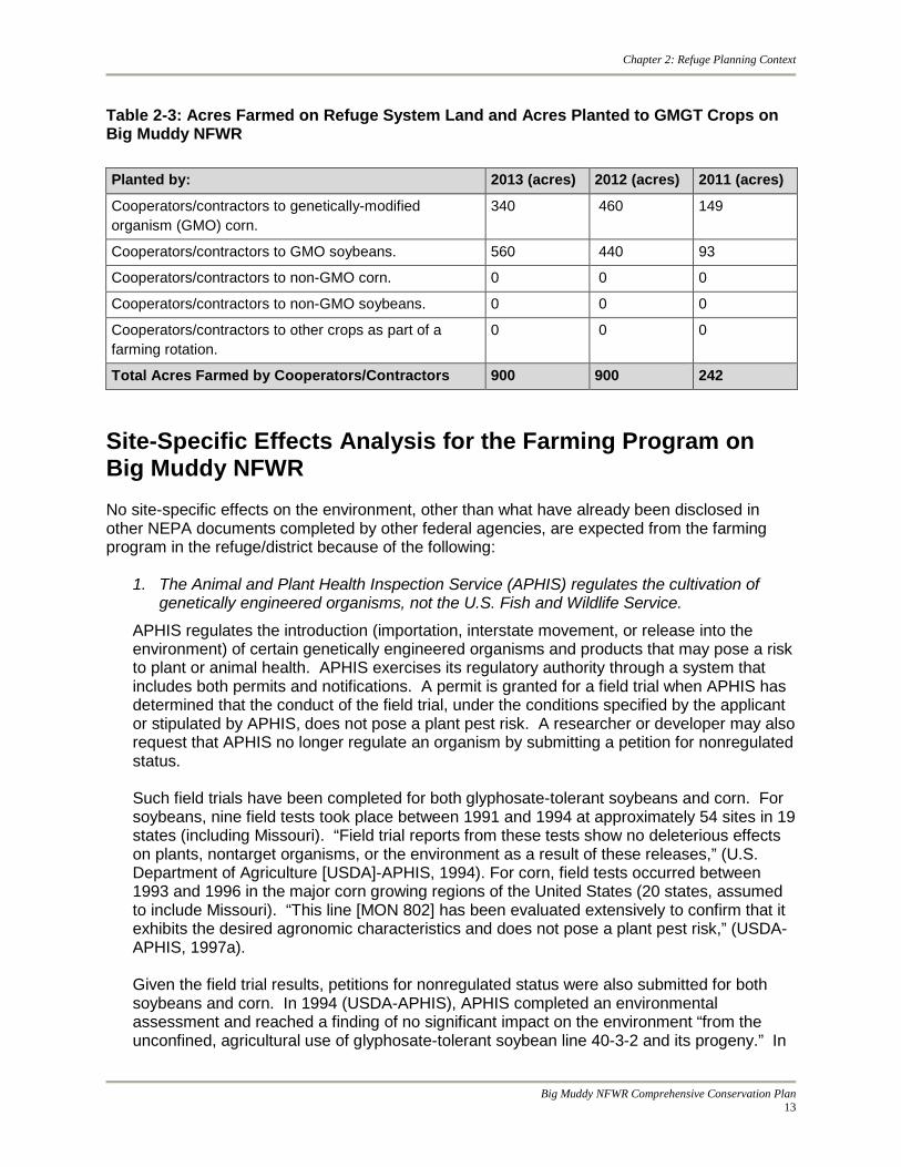
Table 2-3: Acres Farmed on Refuge System Land and Acres Planted to GMGT Crops on Big Muddy NFWR
Site-Specific Effects Analysis for the Farming Program on Big Muddy NFWR No site-specific effects on the environment, other than what have already been disclosed in other NEPA documents completed by other federal agencies, are expected from the farming program in the refuge/district because of the following:
1. The Animal and Plant Health Inspection Service (APHIS) regulates the cultivation of genetically engineered organisms, not the U.S. Fish and Wildlife Service.
APHIS regulates the introduction (importation, interstate movement, or release into the environment) of certain genetically engineered organisms and products that may pose a risk to plant or animal health. APHIS exercises its regulatory authority through a system that includes both permits and notifications. A permit is granted for a field trial when APHIS has determined that the conduct of the field trial, under the conditions specified by the applicant or stipulated by APHIS, does not pose a plant pest risk. A researcher or developer may also request that APHIS no longer regulate an organism by submitting a petition for nonregulated status. Such field trials have been completed for both glyphosate-tolerant soybeans and corn. For soybeans, nine field tests took place between 1991 and 1994 at approximately 54 sites in 19 states (including Missouri). “Field trial reports from these tests show no deleterious effects on plants, nontarget organisms, or the environment as a result of these releases,” (U.S. Department of Agriculture [USDA]-APHIS, 1994). For corn, field tests occurred between 1993 and 1996 in the major corn growing regions of the United States (20 states, assumed to include Missouri). “This line [MON 802] has been evaluated extensively to confirm that it exhibits the desired agronomic characteristics and does not pose a plant pest risk,” (USDA-APHIS, 1997a). Given the field trial results, petitions for nonregulated status were also submitted for both soybeans and corn. In 1994 (USDA-APHIS), APHIS completed an environmental assessment and reached a finding of no significant impact on the environment “from the unconfined, agricultural use of glyphosate-tolerant soybean line 40-3-2 and its progeny.” In
Planted by: 2013 (acres) 2012 (acres) 2011 (acres)
Cooperators/contractors to genetically-modified organism (GMO) corn.
340 460 149
Cooperators/contractors to GMO soybeans. 560 440 93
Cooperators/contractors to non-GMO corn. 0 0 0
Cooperators/contractors to non-GMO soybeans. 0 0 0
Cooperators/contractors to other crops as part of a farming rotation.
0 0 0
Total Acres Farmed by Cooperators/Contractors 900 900 242
Big Muddy NFWR Comprehensive Conservation Plan
13
Chapter 2: Refuge Planning Context
1997 (USDA-APHIS, 1997a), a similar environmental assessment was completed with a finding that “MON 802 corn will not have a significant adverse impact on organisms beneficial to plants or agriculture, or other nontarget organisms, and will not affect threatened or endangered species.” APHIS concluded, “There will be no significant impact on the human environment if MON 802 corn and its progeny were no longer considered a regulated article,” (USDA-APHIS, 1997a). Similar field trials, assessment, and finding were completed later in 1997 for glyphosate-tolerant GA21 corn (USDA-APHIS, 1997b). Other extensions of these original petitions have been submitted in more recent years, and similar trials, assessments, and findings have been completed or are underway for other glyphosate-tolerant corn and soybean crop lines. This documentation, which includes analyses of the effects on humans and the environment from growing genetically engineered crops, can be found at the following website: http://www.aphis.usda.gov/biotechnology/petitions_table_pending.shtml. Since another federal agency, APHIS, regulates the cultivation of genetically engineered organisms and that agency has completed NEPA documentation including effects analyses of this activity, the Service relies on the findings from that agency when determining the effects of the same activity on refuge system land. APHIS has both the regulatory authority and the necessary technical expertise to assess effects of genetically engineered crops on the environment, while the Service has no regulatory jurisdiction over that activity. Therefore, no other site-specific effects other than what have already been disclosed by APHIS are expected from cultivation of genetically engineered crops by the Service.
2. The U.S. Environmental Protection Agency (EPA) regulates the use of pesticide
chemicals, including herbicides, in the environment.
The EPA regulates the use of pesticide chemicals, including herbicides, in the environment. Under the Federal Insecticide, Fungicide, and Rodenticide Act (FIFRA), EPA has the authority to regulate the testing, sale, distribution, use, storage, and disposal of pesticides. Before a pesticide may be sold, distributed, or used in the United States, it must be registered under FIFRA. For example, the EPA first issued a registration standard for glyphosate in June of 1986. Because of advances in scientific knowledge, pesticides that were first registered years ago are required by law to be reregistered to make sure that they meet today’s more stringent standards. In evaluating pesticides for reregistration, EPA obtains and reviews a complete set of studies from pesticide producers, describing the human health and environmental effects of each pesticide. Glyphosate was reregistered in 1993 as it was found to “not pose unreasonable risks or adverse effects to humans or the environment.” Furthermore, “EPA determined that the effects of glyphosate on birds, mammals, fish and invertebrates are minimal,” (EPA, 1993). In 1997, permanent tolerances for residues of glyphosate were established in or on raw agricultural commodities including field corn varieties genetically-modified to be tolerant of glyphosate (EPA, 1997). The herbicide 2,4-D has been used since the 1940s as a pre-plant or post-emergent herbicide to control broadleaf weeds on a broad range of crop and non-crop sites, including cornfields. The EPA first issued a registration standard for 2,4-D in 1988, and the herbicide was reregistered in 2005. In summary, the EPA stated, “Some ecological risks are of concern on some sites for some species,” (EPA, 2005). They provide mitigation measures “expected to lessen, but not eliminate, the risk of 2,4-D to wildlife and plants,” (EPA, 2005).
Big Muddy NFWR Comprehensive Conservation Plan 14

Chapter 2: Refuge Planning Context
Currently, 2,4-D is approved for pre-plant and post-emergent application on corn and pre-plant application on soybeans. Dicamba is widely used in agricultural, industrial, and residential settings for the post emergent control of certain broadleaf weeds and woody plants. It was first registered by the EPA in 1967 and was reregistered in 2006 with amendments in 2008 (EPA, 2009). During the reregistration, the EPA determines whether the pesticide meets the "no unreasonable adverse effects" criteria of FIFRA. As a result of the reregistration review, the EPA “determined that all products containing the active ingredient dicamba are eligible for reregistration provided that the risk mitigation measures indicated in the document are adopted,” (EPA, 2009). APHIS is currently considering the deregulation of new genetically engineered corn, soybean, and cotton plants resistant to the herbicides known as 2,4-D and dicamba. However, the use of GMO crops on Big Muddy NFWR is limited to glyphosate-tolerant corn and soybeans (FWS 2011b). Since another federal agency, the EPA, regulates the use of pesticides, and that agency has completed NEPA documentation including effects analyses of this activity, the Service relies on the findings from that agency when determining the effects of the same activity on refuge system land. The EPA has both the regulatory authority and the necessary technical expertise to assess effects of pesticide use on the environment while the Service has no regulatory jurisdiction over that activity. Therefore, no other site-specific effects other than what have already been disclosed by the EPA are expected from pesticide use by the Service. 3. The farming program on the refuge will follow the Service’s Midwest Region
Environmental Assessment (EA) for row crop farming and the use of genetically-modified glyphosate tolerant (GMGT) corn and soybeans on refuge/district land.
In 2011, the Service’s Midwest Region completed an EA for row crop farming and the use of GMGT corn and soybeans on refuge/district land (FWS, 2011b). Under the selected alternative, beginning in calendar year 2012, the use of GMGT corn and soybeans on Refuge System land in the Midwest Region would continue only for the purpose of habitat restoration. According to the EA, the use of GMGT corn and soybeans would be limited to five years on any individual tract being prepared for habitat restoration. Farming could continue to be used as a management tool for achieving multiple objectives; however, it would be limited to non-GMGT crops for objectives other than habitat restoration. Multiple objectives include but are not limited to the following:
o Habitat restoration
o Habitat management
o Supplemental food for wildlife
o Attracting wildlife for viewing and photography
Similarly, the Service’s ecological integrity policy specifies that GMGT crops cannot be used on Refuge System land unless they are “essential to accomplishing refuge [district] purposes.” Habitat restoration is a core objective of most refuges in achieving their purpose and in some circumstances, the use of GMGT crops could be essential. However, habitat
Big Muddy NFWR Comprehensive Conservation Plan
15

Chapter 2: Refuge Planning Context
management, supplemental food, and wildlife viewing objectives can more readily be accomplished without the use of GMGT seeds, and thus, their use is not likely essential.
Furthermore, refuge and district managers are required to demonstrate that their proposed use of GMGT crops is essential for habitat restoration. The Service has established an approval process for the use of GMGT corn and soybeans that includes completion of a Standard Eligibility Questionnaire for Genetically Modified Crops on National Wildlife Refuge System Lands (appendix N of the Big Muddy NFWR Final CCP). When managers propose to use GMGT corn and soybeans, they are required to complete this questionnaire as part of the approval process. There will be strict adherence to the regional programmatic EA regarding the use of GMGT corn and soybeans on Big Muddy NFWR. 4. The farming program on the Refuge will adhere to all national, Department of Interior,
Service, and Region 3 policies regarding pest management and treatments.
Pest management activities on Service land and facilities must conform to all EPA regulations, chemical labels, Material Safety Sheets, and Service and Department of the Interior policies and directives including:
517 DM 1 (http://www.nature.nps.gov/biology/ipm/Documents/DOI517DM1.pdf), 569 FW 1 (http://www.fws.gov/policy/569fw1.html),and 242 FW 7 (http://www.fws.gov/policy/242fw7.html).
These policies state that pests will be managed using an integrated sustainable approach when the pest is detrimental to site management goals and objectives and the planned pest management actions will not interfere with achieving site management goals and objectives.
Service employees use their best professional judgment and available scientific information to select the lowest risk, most effective integrated pest management method, or combination of methods that is feasible for each pest management project.
If chemical treatment is considered, a Pesticide Use Proposal (PUP) must be prepared and approved by an appropriate level supervisor prior to the chemical application.
PUPS are extensive, detailed documents that require specific information about the planned treatment (pest target, threshold for treatment, active ingredient, application rate, application method) as well as a descriptions of the treatment site(s) (soil type, slope, organic content, nearest water, depth to ground water).
The PUPs are valid for only one year and provide a timely, site-specific evaluation of the current conditions. Reports regarding the efficacy of the treatments are required in February of each year so Service staff can evaluate past management actions, and refine and improve subsequent control measures. 5. Best Management Practices (BMPs) are currently being used for the farming program on
the refuge, and a more thorough list of BMPs will be developed for the farming program to follow in the future.
In general, the Refuge System is reducing the amount of farming on national wildlife refuges including the use of genetically-modified crops and pesticides. Farming with genetically-modified crops within refuges is restricted to a very specific purpose (i.e., habitat restoration). Due to the many policies (e.g., Pesticide Use Policy, appendix O of the Big
Big Muddy NFWR Comprehensive Conservation Plan 16

Chapter 2: Refuge Planning Context
Muddy NFWR Final CCP); the regional programmatic EA regarding the use of GMGT corn and soybeans, etc.; the approval processes (e.g., Pesticide Use Proposals, Special Use Permits, Habitat Management Agreements, Memorandums of Understanding, etc.); and guidelines (e.g., Best Management Practices, Regional Direction regarding cooperative farming, etc.) in place governing farming practices on Refuge System land, farming on Big Muddy NFWR is not expected to have the potentially significant adverse effects to the environment as surrounding farming practices on private land. Farming is used on Big Muddy NFWR to accomplish habitat and wildlife goals and purposes. When farming is used to prepare the seed bed of a newly acquired property (typically in row crop agriculture), the refuge uses farming cooperators and Special Use Permits. In the Special Use Permit the Service articulates through stipulations the best management practices that will be used on refuge property. Examples of stipulations include the following: Note: These stipulations may change over time to reflect new information.
o Use of chemicals must be approved through a Pesticide Use Proposal.
o Fall tillage is prohibited.
o Glyphosate tolerant corn and soybean seed may only be used for habitat restoration purposes.
o No insecticides may be used.
Chemical application provides the most effective means for site preparation prior to habitat restoration. Chemical site preparation reduces potential future applications by reducing weed seeds prior to restoration. The following Best Management Practices will be followed to lessen any potential effects from pesticide application on Big Muddy NFWR:
o Allow pesticide application buffers around sensitive areas,
o Follow pesticide labels,
o Spray only when winds are 12 mph or less (but not inversions),
o Control drift through use of low pressure and nozzles that create larger droplets,
o Monitor current and predicted winds,
o Monitor predicted rainfall,
o Be cautious around shallow groundwater, and
o Maintain a buffer around water and wetlands.
6. The land in the farming program within the refuge has been privately farmed for over 50
years, more recently with the use of GMGT crops and pesticides.
Landowners in the floodplain of the Missouri River began farming the floodplain in earnest after about 1945 when the Corps of Engineers began building flood control levees along the river. Over time, most of the floodplain was protected from annual flooding and more and more land was cleared for farming. The number of farms tended to decrease over time, but the size of farms steadily increased. Scientific advances in biotechnology (crop genetics, broadcast treatment of weeds, etc.) as well as general technology (larger and more
Big Muddy NFWR Comprehensive Conservation Plan
17
Chapter 2: Refuge Planning Context
aggressive tillage equipment, more accurate planting and harvesting equipment, etc.) continue to change and influence farming today as it did in the past. Farming on Big Muddy NFWR will occur on only previously disturbed areas such as previously farmed or currently farmed land. The farming program is simply used as a tool to prepare the seedbed for restoration of natural habitat.
In summary, no significant effects are expected from any of the proposed activities, based on the effects analysis completed in the EA for Big Muddy NFWR Draft CCP as well as the various effects analyses completed and cited above by APHIS regarding genetically engineered crops and the EPA regarding pesticide regulation. These analyses together constitute a “hard look” at the potential effects on the environment from the farming program on Big Muddy NFWR. Furthermore, various Section 7 consultations with the Ecological Services branch of the Service in concurrence, have been completed for pesticide use on Big Muddy NFWR regarding threatened and endangered species. Relationship to Other Conservation Initiatives Migratory Bird Conservation Initiatives Several migratory bird conservation plans have been published over the last decade that can be used to help guide management decisions for the refuge. Bird conservation planning efforts have evolved from a largely local, site-based orientation to a regional, even inter-continental, landscape-oriented perspective. Several transnational migratory bird conservation initiatives have emerged to help guide the planning and implementation process. The regional plans most relevant to the majority of the refuge are:
• The Upper Mississippi River and Great Lakes Region Joint Venture (UMR/GLR JV) Waterfowl Habitat Conservation Strategy (http://www.uppermissgreatlakesjv.org/);
• The UMR/GLR JV Landbird Habitat Conservation Strategy;
• The UMR/GLR JV Shorebird Habitat Conservation Strategy;
• The UMR/GLR JV Waterbird Habitat Conservation Strategy; and
• The Central Hardwoods Joint Venture Concept Plan (http://www.chjv.org/CHJV_Strategic_Plan.html).
These plans are products of stepping-down and incorporating all other larger-scale (North American, United States, International, etc.) species and other management plans, in particular the North American Waterfowl Management Plan. The UMR/GLR JV of the North American Waterfowl Management Plan is an effort to safeguard the waterfowl habitats of the Nation's only inland coastal area—the Great Lakes—plus interior wetlands, including the floodplains of four of the country's major river systems: the lower Missouri, upper Mississippi, the Illinois, and Ohio. More recently, this effort also includes protecting or increasing habitat for upland wildlife species that are associated with wetland habitats and that of declining non-waterfowl migratory birds, as long as the efforts were consistent with waterfowl objectives. Therefore, the UMR/GLR JV is concerned with delivering a full spectrum of bird conservation (sustainable populations of all birds) through regionally based, biologically driven, landscape-oriented partnerships.
Big Muddy NFWR Comprehensive Conservation Plan 18

Chapter 2: Refuge Planning Context
More specifically, the refuge spans across the Eastern Tallgrass Prairie and Central Hardwoods Bird Conservation Regions (BCR) 22 and 24. The Central Hardwoods BCR description probably best characterizes the refuge. The region includes some of the most extensive forests in the middle of the continent, much of it oak-hickory deciduous forest in the uplands, which support forest interior bird species such as Cerulean Warbler, Worm-eating Warbler, and Louisiana Waterthrush. Although Wood Ducks are the primary breeding waterfowl, the region holds more significance for waterfowl as a migratory staging area. The floodplains of the river systems exhibit a diversity of habitats (e.g., floodplain forests, emergent wetlands, and submerged aquatic beds), all of which are utilized by migrating waterfowl. Large concentrations of waterfowl, including Mallard, Lesser Scaup, and Canvasback, are common during both spring and fall migration. Threats to the habitats of the region include agricultural conversion of floodplain habitats and urbanization. BCRs 22 and 24 contain 47 bird species listed as “Of Conservation Concern” by the Service (FWS 2008b). This list identifies species, subspecies, and populations of all migratory non-game birds that, without additional conservation actions, are likely to become candidates for listing under the Endangered Species Act. The overall goal of this report is to accurately identify the migratory and non-migratory bird species (beyond those already designated as federally threatened or endangered) that represent the Service’s highest conservation priorities. The Service based its 2008 list of Birds of Conservation Concern primarily on the landbird, shorebird, and waterbird status assessment scores. Some of the species on this list include: American Bittern (Botaurus lentiginosus), Bell’s Vireo (Vireo bellii), Black-crowned Night-Heron (Nycticorax nycticorax), Cerulean Warbler (Setophaga cerulea), Horned Grebe (Podiceps auritus), Prothonotary Warbler (Protonotaria citrea), Short-billed Dowitcher (Limnodromus griseus), Short-eared Owl (Asio flammeus), Upland Sandpiper (Bartramia longicauda), Wood Thrush (Hylocichla mustelina), and Worm-eating Warbler (Helmitheros vermivorum). Landscape Conservation Cooperatives The Service, with support and cooperation from the U.S. Geological Survey, has developed a national geographic framework for “putting science in the right places” to conserve our Nation’s fish and wildlife resources. Just as flyways provided an effective spatial frame of reference to build capacity and partnerships for international, national, state, and local waterfowl conservation, the national geographic framework provides a continental platform upon which the Service can work with state and other partners to connect project- and site-specific efforts to larger biological goals and outcomes. By providing visual context for conservation at “landscape” scales—the entire range of a priority species or suite of species—the framework helps ensure that resource managers have the information and decision making tools they need to conserve fish, wildlife, plants and their habitats in the most efficient and effective way possible.
Diversity of habitats; photo: Steve Hillebrand
Big Muddy NFWR Comprehensive Conservation Plan
19

Chapter 2: Refuge Planning Context
The Service is using the framework as a basis for locating Landscape Conservation Cooperatives (LCCs). Facilitated by DOI as part of its collaborative, science-based response to climate change, LCCs complement and build upon existing science and conservation efforts—such as fish habitat partnerships and migratory bird joint ventures as well as water resources, land, and cultural partnerships. Big Muddy NFWR planning area is split across the Eastern Tallgrass Prairie and Big Rivers LCC and the Gulf Coastal Plains and Ozarks LCC, just two of a network of partnerships working in unison to ensure the sustainability of America’s land, water, wildlife, and cultural resources (figure 2-2). Figure 2-2: Relationship of Big Muddy NFWR to Landscape Conservation Cooperatives
Both LCCs conduct research, develop tools that improve natural resource management, and conduct outreach. Their goal is to focus coordinated action and eliminate duplication to support shared conservation priorities across large connected areas, or landscapes. The Eastern Tallgrass Prairie and Big Rivers LCC cuts a vast swath across the middle of America's heartland, covering the area more commonly referred to as the "corn belt." While the landscape is predominantly agricultural and in private ownership, the area also contains numerous state and federally managed tracts of land providing habitat for a wide variety of aquatic and terrestrial species of wildlife. This LCC contains portions of some of America's premier rivers including the Mississippi, Missouri, Illinois, Wisconsin, Ohio, and Wabash—each providing critical riverine corridor habitat for wildlife as well as a wide variety of natural lakes and reservoirs. The Gulf Coastal Plains and Ozarks LCC encompasses all of Arkansas and
Big Muddy NFWR Comprehensive Conservation Plan 20

Chapter 2: Refuge Planning Context
Mississippi and parts of 10 additional states, from Missouri to eastern Texas to the Florida panhandle. Strategic Habitat Conservation Strategic habitat conservation (SHC) is a science-based approach to conservation focused on providing landscapes capable of sustaining trust species populations at objective levels. This approach is founded on an adaptive, iterative process of biological planning, conservation design, conservation delivery, monitoring, and research. SHC is an application of the scientific method and adaptive management to conservation at multiple spatial scales. This strategic conservation approach will include all Service programs and address both habitat and non-habitat factors limiting fish and wildlife populations As a leader in fish and wildlife and habitat conservation and management, the Service is embracing a framework designed to maximize agency efficiency and increase on the ground conservation impacts. SHC enables the Service to:
• Respond to new environmental challenges;
• Advance opportunities with new and existing partners;
• Utilize science-based tools and resources to plan and evaluate our conservation efforts; and
• Continue to ensure conservation successes locally, while advancing landscape objectives.
The Service mission can be met at a landscape scale, especially in the face of climate change, by:
• Fully utilizing existing technology such as GIS;
• Becoming trained in better decision making through the structured decision making process;
• Reaching out to even more partners that have the necessary expertise to advance knowledge of the resource and its needs at multiple spatial and temporal scales; and
• Being diligent and transparent in planning and decision making processes.
SHC Guiding Principles
• Habitat conservation is simply a means to attain the Service’s true goal—the conservation of populations and ecological functions that sustain them;
• Defining measurable population objectives is a key component of SHC, at any scale;
• Biological planning must use the best scientific information available, both as a body of knowledge and a method of learning. Service understanding of ecological conditions is never perfect. An essential element of SHC is managing uncertainty through an iterative cycle of planning, doing, and evaluating;
Big Muddy NFWR Comprehensive Conservation Plan
21

Chapter 2: Refuge Planning Context
• Management actions, decisions, and recommendations must be defensible and explicit about the nature and magnitude of potential errors;
• Conservation strategies consist of dynamic suites of objectives, tactics, and tools that change as new information enters the SHC cycle; and
• Partnerships are essential, both for management and for developing conservation strategies.
Region 3 Fish and Wildlife Conservation Priorities Every species is important; however, the number of species in need of attention exceeds the resources of the Service. To focus effort effectively, Region 3 of the Service compiled a list of Resource Conservation Priorities. The list includes:
• All federally listed threatened and endangered species and proposed and candidate species that occur in the Region;
• Migratory bird species derived from Service-wide and international conservation planning efforts; and
• Rare and declining terrestrial and aquatic plants and animals that represent an abbreviation of the Endangered Species program’s preliminary draft “Species of Concern” list for the Region.
Climate Change Planning U.S. Fish and Wildlife Service The Service’s Rising to the Urgent Challenge: Strategic Plan for Responding to Accelerating Climate Change (FWS 2010b) establishes a basic framework within which the Service will work as part of the larger conservation community to help ensure the sustainability of fish, wildlife, plants, and habitats in the face of accelerating climate change. It was developed in an effort to rise up and respond to, as well as in recognition of, what is perhaps the 21st century’s largest stressors on fish, wildlife, and plants: climate change. Part of the plan’s primary purposes is to lay out a vision for accomplishing the Service mission to “work with others to conserve, protect, and enhance fish, wildlife, and plants and their habitats for the continuing benefit of the American people” in the face of accelerating climate change. In this plan, a commitment to the Service’s vision is expressed through strategic goals and objectives that must be accomplished to sustain fish and wildlife nationally and internationally. A 5-Year Action Plan for Implementing the Climate Change Strategic Plan identifies specific actions that will lead to the accomplishment of these goals and objectives. The goals and objectives most relevant to this planning effort include the following: Goal 2: We will develop long-term capacity for biological planning and conservation design and apply it to drive conservation at broad, landscape scales:
• Objective 2.1: Access regional climate science and modeling expertise through regional climate science partnerships.
Big Muddy NFWR Comprehensive Conservation Plan 22

Chapter 2: Refuge Planning Context
• Objective 2.2: Develop landscape conservation cooperatives to acquire biological planning and conservation design expertise.
• Objective 2.3: Develop expertise in and conduct adaptation planning for key species and habitats.
• Objective 2.4: Incorporate climate change in service activities and decisions.
• Objective 2.5: Provide requested support to state and tribal managers to address climate change issues that affect fish and wildlife service trust resources.
• Objective 2.6: Evaluate fish and wildlife service laws, regulations, and policies to identify barriers to and opportunities for successful implementation of climate change actions.
Goal 3: We will plan and deliver landscape conservation actions that support climate change adaptations by fish and wildlife of ecological and societal significance.
• Objective 3.1: Take conservation action for climate-vulnerable species.
• Objective 3.2: Promote habitat connectivity and integrity.
• Objective 3.3: Reduce non-climate change ecosystem stressors.
• Objective 3.4: Identify and fill priority freshwater needs.
• Objective 3.5: Conserve coastal and marine resources.
• Objective 3.6: Manage genetic resources.
• Objective 3.7: Reduce susceptibility to diseases, pathogens, and pests.
• Objective 3.8: Address fish and wildlife needs in renewable energy development.
• Objective 3.9: Foster international collaboration for landscape conservation.
The Conserving the Future: Wildlife Refuges and the Next Generation (2011) document is the Service’s bold, new vision for the National Wildlife Refuge System. This 21st century strategic vision for the Refuge System acknowledges the broad social, political, and economic changes that have made habitat conservation more challenging since the agency last set comprehensive goals in 1999. In the intervening 12 years, the new vision states the Nation’s population has grown “larger and more diverse . . . and the landscape for conservation has changed—there is less undeveloped land, more invasive species, and we are experiencing the impacts of a changing climate.” The document includes 24 recommendations to guide the future of the National Wildlife Refuge System. The recommendation most relevant to this planning effort concerning climate change is:
• Recommendation 2: Develop a climate change implementation plan for the National Wildlife Refuge System that dovetails with other conservation partners’ climate change action plans and specifically provides guidance for conducting vulnerability assessments of climate change impacts to refuge habitats and species as well as direction for innovation in the reduction of emissions and improved energy efficiency on federal lands.
Big Muddy NFWR Comprehensive Conservation Plan
23

Chapter 2: Refuge Planning Context
State of Missouri There is no climate change plan specific to Missouri available at this writing. Missouri’s Comprehensive Wildlife Strategy Congress asked each state to develop a comprehensive wildlife strategy, later renamed wildlife action plan. These plans examine the health of wildlife and prescribe actions to conserve wildlife and vital habitat before they become rarer and more costly to protect. Using wildlife information gathered over the past 30 years, Missouri's comprehensive wildlife strategy promotes management that benefits all wildlife, rather than targeting single species. The strategy identifies 33 Conservation Opportunity Areas in which management strategies will conserve both wildlife populations and the natural systems on which they depend. For each Conservation Opportunity Area, a team of partners developed a common vision of issues and actions. Six Conservation Opportunity Areas occur along the Missouri River: Upper Blue River, Wakenda Bottoms, Manitou Bluffs, Bonne Femme Karst, Missouri River Hills, and Missouri/Mississippi River Confluence. Partners for Fish and Wildlife Program At the heart of the Service's mission are the conservation and management of the Federal Trust Species: migratory birds; threatened and endangered species; inter-jurisdictional fish; certain marine mammals; and species of international concern. It is estimated that 73 percent of land in the United States and 93 percent of the land in Missouri is privately owned and that the majority of our fish and wildlife resources occur on those lands. Consequently, the conservation lands held by federal and state agencies and other conservation groups cannot completely provide for fish and wildlife needs. Because the habitat needs of all Trust Species cannot be met solely on public lands, public funds are also expended on private lands to accomplish habitat improvements through cooperative conservation programs such as the Partners for Fish and Wildlife Program (Partners Program). The Partners Program provides technical and financial assistance to private landowners and tribes who are willing to work with the Service and other partners on a voluntary basis to help meet the habitat needs of the Service’s Federal Trust Species. The Partners Program assists with projects in all habitat types, which conserve or restore native vegetation, hydrology, and soils associated with imperiled ecosystems. Locally based field biologists work one-on-one with private landowners and other partners to plan, implement, and monitor their projects. Partners Program field staff help landowners find other sources of funding and help them through the permitting process, as necessary. This level of personal attention and follow-through is a significant strength of the Partners Program that has led to national recognition and wide support. The Partners Program is guided by a national policy (FWS 2003b) that identifies the following objectives:
• Promote and implement habitat improvement projects that benefit Federal Trust Species;
• Provide conservation leadership and promote partnerships;
• Encourage public understanding and participation; and
Big Muddy NFWR Comprehensive Conservation Plan 24

Chapter 2: Refuge Planning Context
• Work with U.S. Department of Agriculture (USDA) to implement conservation programs.
The Big Muddy NFWR is engaged in a multi-partner cooperative conservation effort at the confluence of the Missouri and Mississippi Rivers. Partners include Audubon Missouri, The Nature Conservancy, The Trust for Public Land, the USACE – Riverlands Migratory Bird Sanctuary, Missouri Department of Conservation, Missouri Department of Natural Resources ̶ State Parks Division, Great Rivers Habitat Alliance, Greenway Network, Ducks Unlimited, and numerous private waterfowl hunting clubs and citizens. The Service’s Missouri Partners for Wildlife Office was instrumental in developing this partnership. This Public-Private partnership has leveraged funds and other resources to protect thousands of acres of land, develop education and interpretation programs, and increase opportunities for wildlife oriented public use. Volunteers have planted thousands of trees and native prairie plants on public lands, including the Cora Island Unit of the Big Muddy NFWR, held invasive species eradication workdays, river cleanup events on public and private land, and held education events for the public. The confluence Partnership continues to have a positive influence in this important area. Important Bird Areas Important Bird Areas (IBAs) are sites that provide essential habitat for one or more species of bird. IBAs include sites for breeding, wintering, and/or migrating birds. IBAs may be a few acres or thousands of acres, but usually they are discrete sites that stand out from the surrounding landscape. IBAs may include public or private lands, or both, and they may be protected or unprotected. To qualify as an IBA, a site must satisfy at least one of the following criteria. The site must support:
• Species of conservation concern (e.g., threatened and endangered species);
• Restricted-ranges species (species that are vulnerable because they are not widely distributed);
• Species that are vulnerable because their populations are concentrated in one general habitat type or biome; or
• Species, or groups of similar species (such as waterfowl or shorebirds), that are vulnerable because they occur at high densities due to their congregatory behavior.
Currently, three IBAs exist within or very close to the Missouri River floodplain between Kansas City and St. Louis. Some portions of these IBA’s are part of the refuge. Wetland Reserve Program At one time, wetlands covered 4.8 million acres in Missouri. They began to decline in the late 1800s amid competing uses for the land. Today, 800,000 acres remain. The USDA’s Wetlands Reserve Program (WRP), administered by the Natural Resources Conservation Service (NRCS), is a voluntary program offering landowners the opportunity to protect, restore, and enhance wetlands on their property. The goal of NRCS is to achieve the greatest wetland functions and values, along with optimum wildlife habitat, on every acre enrolled in the program. Missouri was one of nine states to first enroll in the program and is one of the leading states in both number and area of easements enrolled. Currently, the State of Missouri has 994 wetlands
Big Muddy NFWR Comprehensive Conservation Plan
25

Chapter 2: Refuge Planning Context
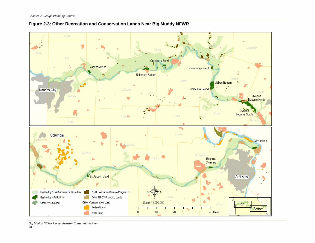
easements covering 140,000 acres, much of which is concentrated in the Missouri River floodplain. The Emergency Wetlands Reserve Program authorized in 1993 in response to major flooding throughout the Midwest provided payments to purchase easements and partial financial assistance to landowners who permanently restored wetlands at sites where restoration costs exceeded the land’s fair market value. Land enrolled in this program is considered part of the WRP and accounts for the concentration of these lands along the Missouri River floodplain. Conservation Reserve Program The USDA's Conservation Reserve Program (CRP) protects millions of acres of United States’ topsoil from erosion and is designed to safeguard the Nation's natural resources. By reducing water runoff and sedimentation, CRP protects ground water and helps improve the condition of lakes, rivers, ponds, and streams. Since an emphasis is placed on wetland and native prairie restoration as a condition of enrollment, the program has also become a major contributor to increased wildlife populations in many parts of the country. According to the USDA Farm Service Agency, the total acres enrolled in CRP within the 20 counties that contain the Missouri River floodplain in Missouri is just over 205,000. Carroll and Chariton Counties have the most CRPs currently enrolled, while St. Louis and Jackson Counties have the least. Other Recreation and Conservation Lands in the Area There are numerous tracts of public land managed by county, state and other federal agencies near the Big Muddy NFWR (figure 2-3). Several of the more prominent and representative areas are described below. The Missouri Department of Conservation manages several large conservation areas in the Missouri River floodplain, including the Columbia Bottom Wildlife Area , 4,318 acres, on the south bank of the Missouri River at the confluence with the Mississippi. Columbia Bottom Wildlife Area boasts a visitor center, hiking trails, a boat ramp on the Missouri River, hunting programs and managed wetlands. The MDC also manages the Eagle Bluffs (4,269 acres) and Grand Pass (5,296 acres) Wildlife Areas in Boone and Saline Counties respectively. These two areas are intensively managed for waterfowl and waterfowl hunting. Other activities include fishing , hiking, wildlife observation and hunting species other than waterfowl. The Baltimore Bend Wildlife Area (1,192 acres) overlooks the Big Muddy NFWR Baltimore Bottom Unit. One of the refuge parking facilities and information kiosk is located on the MDC area. The Missouri Department of Natural Resources, State Parks Division, manages several large
Hunting at Overton; photo: Carol Weston
Big Muddy NFWR Comprehensive Conservation Plan 26

Chapter 2: Refuge Planning Context
riverfront parks along the Missouri River. The Confluence State Park (1,100 acres) on the north bank of the Missouri River at the confluence with the Mississippi River is directly across the Missouri River from the MDC Columbia Bottom Wildlife Area and 1 mile downstream from the Big Muddy NFWR Cora Island Unit. The Katy Trail State Park runs along the Missouri River from near the confluence upstream to river mile 199, providing hiking and biking opportunities. The Arrow Rock State Park and Historic Site overlooks he Big Muddy NFWR Jameson Island Unit and is connected via a jointly managed interpretive hiking trail.
Big Muddy NFWR Comprehensive Conservation Plan
27
Chapter 2: Refuge Planning Context
Figure 2-3: Other Recreation and Conservation Lands Near Big Muddy NFWR
Big Muddy NFWR Comprehensive Conservation Plan 28

Chapter 2: Refuge Planning Context
The Planning Process Public Involvement Initial conversations about comprehensive planning for Big Muddy NFWR began mid-year of 2007 to review policy, discuss the core team, tour the refuge, and gather background information. The initial phase of the planning process—scoping—officially began on May 16, 2007 when a Notice of Intent to prepare a Comprehensive Conservation Plan (CCP) appeared in the Federal Register. Scoping, according to the Council on Environmental Quality Regulations for implementing National Environmental Policy Act (NEPA), is “an early and open process for determining the scope of issues to be addressed and for identifying the significant issues related to the proposed action.” In October 2007 Regional Office planners and refuge staff met to discuss likely planning issues, data needs, and to develop a draft version of the refuge vision and goals for public review. A planning team formed, made up of refuge staff, Regional Office planning staff, representatives from other programs within the Service, and representatives from MDC. Formal public scoping began in December 2007 with a series of public open houses held in seven communities along the Missouri River across the state. We announced the meetings via letters to those on the refuge mailing list, the Big Muddy NFWR planning web page, local media outlets, and e-mail distribution lists. Collectively, more than 100 people attended the open house meetings and submitted dozens of comments. See table 2-4 for a summary of scoping and planning events. Comments gathered during public scoping as well as comments from Service staff form the basis of a number of planning issues (see Planning Issues below). The planning team met with invited representatives from the Service, MDC, and USACE to discuss refuge management concerns and opportunities and develop a range of alternatives in response to the planning issues.
Big Muddy NFWR Comprehensive Conservation Plan
29

Chapter 2: Refuge Planning Context
Table 2-4: Summary of Scoping and Planning Events Date Event May 16, 2007 A Notice of Intent to prepare a CCP was published in the Federal Register
marking the official start of the scoping process. October 23, 2007 The planning team held a meeting with refuge staff to kick off the CCP
process and collect comments on known issues and opportunities and develop a draft version of the refuge vision and goals.
December 3–6, 2007 December 12, 2007 January, 14, 2008 January 15, 2008
A series of open house meetings occurred in the following Missouri communities: Columbia, Linn, Fayette, Arrow Rock, Chesterfield, Richmond, and Waverly.
February 5–7, 2008 A biological planning session that included representatives from the Service, Missouri Department of Natural Resources, Natural Resources Conservation Service, Missouri Department of Conservation, University of Missouri, and the U.S. Geological Service was held in Columbia, Missouri.
February 20, 2008 The planning team held a meeting in the Midwest Regional Office at Fort Snelling, Minnesota to collect additional comments from regional staff on issues and opportunities associated with the refuge.
September 13–15, 2011
The planning team, including representatives from the Service, MDC, and USACE met to develop alternatives.
November 12, 13, 14, and 19
A series of open house meetings to answer questions and accept comments on the EA and Draft CCP occurred in the following Missouri communities: Columbia, Arrow Rock, Chesterfield, and Richmond.
Development of the Management Alternatives The planning team fully developed two alternatives in addition to the No Action alternative using the following process: We invited representatives from Service programs, the U.S. Army Corps of Engineers (USACE), and the Missouri Department of Conservation (MDC) to participate in a workshop to develop management alternatives. Small groups worked independently to assess and respond to each of the three driving issues (see Planning Issues later in this chapter). Each group received maps of the planning area, a summary of the planning issues, a summary of an earlier workshop on biological resources, and instructions to consider the entire planning area, which encompasses the 11 existing refuge units as well as potential future units. Following the workshop, members of the planning team compiled the results in the form of a survey and solicited responses from those invited to the workshop. The survey responses in conjunction with information produced at the workshop formed the basis for the range of alternatives. The three alternatives represent different approaches to the protection, restoration, and management of the refuge’s fish, wildlife, plants, habitats, and other resources as well as to compatible wildlife-dependent recreation. We considered one other alternative, but did not develop it in detail. Preparation and Review of Environmental Assessment and Draft Plan The EA and Draft CCP was released for a 30-day public review with publication of a Notice of Availability in the Federal Register on October 1, 2013, followed by a news release made through local media outlets, a postcard announcement sent to the CCP mailing list, the distribution of an e-mail announcement, the delivery of paper copies of the full document to local libraries, and by making an electronic copy available on the Service’s website. Due to a federal government shutdown from October 1–16, 2013, the public review period was extended an
Big Muddy NFWR Comprehensive Conservation Plan 30

Chapter 2: Refuge Planning Context
additional three weeks until November 20, 2013. Open house meetings, where people could ask questions and submit comments on the EA and Draft CCP, took place on November 12 (Columbia), November 13 (Arrow Rock), November 14 (Chesterfield), and November 19 (Richmond). Twelve people attended the open houses, and a total of four comments were submitted to the refuges during public review. Additional information from the public review and comment period is provided in the Response to Comments (appendix M). Preparation and Review of the Final Plan A thorough review of the Draft CCP document and proposed management direction was undertaken, and where appropriate comments received by the Service on the EA/Draft CCP were incorporated into the final version of the CCP. As with the Draft CCP, the availability of the Final CCP was announced with a notice in the Federal Register and through local media outlets, a final postcard and/or e-mail announcement was sent to the project mailing list, full copies of the document were sent to local libraries, and an electronic copy was made available on the Service’s website. The Final CCP document is the basis for management of the refuge for 15 years. It guides the development of more detailed, resource-specific step-down management plans, and lays out the general approach to managing habitat, wildlife, and visitor services at Big Muddy NFWR, guiding day-to-day actions and decision making. Implementation Implementation begins immediately following approval of the CCP and public notification of the decision. Funding and staff time will be allocated to implement of the CCP as appropriations, budgets, and other resources allow. Step-Down Management Plans The CCP is a plan that provides general concepts and specific wildlife, habitat, and people-related objectives. Step-down management plans provide detail to managers and employees who will carry out the strategies described in the CCP. The refuge staff will develop the following step-down plans after completion of this CCP (table 2-5): Table 2-5: Step-Down Management Plan Completion Time Step-Down Management Plan Amount of Time for Completion after CCP Approval Habitat Management Plan(HMP) 2 years Inventory and Monitoring Plan(IMP) 2 years Visitor Services Plan (VSP) 1 year
Inventory, Monitoring, and Research Following approval of the CCP and public notification of the decision, implementation will begin. Funding and staff time will be allocated to implementation of the CCP as appropriations and budgets allow. Development of a stepped down HMP and other plans (i.e., Visitor Services Plan) will begin and serve to guide habitat management, restoration and reconstruction priorities and public use. A companion IMP or additional chapters on inventory and monitoring appended to the HMP will be written to guide the refuge’s priorities for monitoring. Information gained via
Big Muddy NFWR Comprehensive Conservation Plan
31

Chapter 2: Refuge Planning Context
inventories, monitoring or research activities will allow the station to evaluate its progress in achieving the planning unit purposes, vision, and goals. The associated step-down plans will address habitat and/or population objectives, and provide a means for evaluating the effects of management activities and public use. Through adaptive management, evaluation of monitoring and research results may indicate the need to modify refuge objectives or strategies. Plan Review and Revision The CCP provides guidance to the refuge manager and staff over the next 15 years. However, the CCP is also a dynamic and flexible document, and several of the strategies contained in this plan are subject to uncontrollable events of nature. Likewise, many of the strategies are dependent upon Service funding for staff and projects. For these reasons, the recommendations in the CCP will be reviewed annually and, if necessary, revised (FWS 2000c). The annual plan review process will include an evaluation of changing information and ecological conditions related to climate change. If significant changes are identified and comprise the refuge’s purpose, vision, or goals, then the CCP will be revised. The CCP will be revised every 15 years, or sooner when significant new information becomes available, ecological conditions change, major refuge expansion occurs, or when determined necessary by the periodic review (FWS 2000c). All plan revisions will follow the Service’s planning process and will be compliant with NEPA. Minor plan revisions that meet the criteria of a categorical exclusion will be handled in that manner; however, if the plan requires a major revision, then the CCP process starts anew at the preplanning step (FWS 2000c). Planning Issues Planning is a means to address issues. Issues associated with comprehensive conservation planning arise from both within and outside of the Service and are defined as any unsettled matter, whether a problem or an opportunity, that requires a management decision. Public scoping as well as scoping of the Service’s refuge and regional staff and other agencies took place and produced a wide range of individual comments. We grouped comments that were similar into 15 separate issues, each expressed below as a short statement or question along with a brief description or explanation. We sorted the issues according to specific criteria. First, we evaluated each issue to see if it fit within the scope of the planning process and found three of the 15 were outside the scope. We identify those issues below along with an explanation of their exclusion. Next, we reviewed the remaining issues and sorted them into two categories: 1) driving issues: those that suggested a range of possible changes in management, and 2) non-driving issues: those that did not suggest a range of possible changes in management. This produced eight driving issues, which we consolidated into three groups: Land and Water Conservation, Visitor Services and Refuge Administration, and Conservation Footprint. These final three issue groupings are the basis for the planning alternatives. We considered the non-driving issues throughout the planning process, but addressed them the same way under each alternative. Issues outside the Scope of the Planning Process Issue There are both support and opposition to further land acquisition by the refuge.
Big Muddy NFWR Comprehensive Conservation Plan 32

Chapter 2: Refuge Planning Context
Explanation This issue is beyond the scope of this planning process and not considered further, because a previous planning process that included public scoping and review determined the amount of land authorized for acquisition from willing sellers. A 1999 ROD for the Big Muddy NFWR FEIS approved expansion of the refuge for up to 60,000 acres for restoration and preservation efforts to reconnect the floodplain to the Missouri River. Issue Federal payments to states do not always fully offset loss of tax revenue resulting from federal ownership. Explanation This issue is beyond the scope of this planning process and not considered further because Congress, not the Service, ultimately determines federal payments to states. The Refuge Revenue Sharing Act is the law that governs federal payments to states to offset loss of tax revenue for lands acquired by the Service. The net income the Service receives from products or privileges—like timber sales, grazing fees, and right-of-way permit fees—from all acquired lands is deposited in the National Wildlife Refuge Fund for revenue sharing payments. If there is not enough money in the National Wildlife Refuge Fund to cover the payments, Congress is authorized to appropriate money to make up the difference. If the amount Congress appropriates is not enough, the units of local government receive a pro-rata share. Issue The annual flow regime of the Missouri River affects refuge resources and the ability to fulfill refuge purposes and other conservation priorities. Explanation This issue is beyond the scope of this planning process and not considered further, because the factors that affect Missouri River flow are not under refuge control. In the typical pre-development Missouri River flow regime, a flood pulse resulted from rain and melting snow runoff, first in March from the Great Plains and then during late June from the Rocky Mountains. Flows declined through the summer and fall reaching their low point in late December. Native fish and wildlife evolved with this historical flow regime and depend on it to meet their different seasonal habitat and reproductive needs. Today a spring flood pulse is suppressed via reservoir storage, while dam releases provide higher river flows from July through November, eliminating summer/fall low-water flows. Seasonally inundated backwaters and wetlands historically provided food and habitat for native river fishes. The suppression of high spring flows has prevented recharging of these areas, reduced nutrient cycling and transport and accessibility to floodplain and nursery habitats for fishes. In relation to pre-development conditions, few high elevation sandbars form because of the suppression of high flows which are necessary to create them. Sandbars that do remain become covered with unwanted vegetation, because the scouring flows needed to clear them are unavailable. Native fish spawning cues once triggered by increasing water temperatures coupled with rising river stages have been lost within many river reaches. Issues that Drive Alternatives Driving issues are those that suggest a range of possible changes to refuge management and are the basis for alternative development. The driving issues appear under three headings:
• Land and Water Conservation
Big Muddy NFWR Comprehensive Conservation Plan
33

Chapter 2: Refuge Planning Context
• Visitor Services and Refuge Administration
• Conservation Footprint
Land and Water Conservation Issue What types and intensities of habitat management should be used to help fulfill refuge purposes, the mission of the NWRS, and/or other conservation priorities? Description Historically, forested, grassland, and wetland habitats occurred along the Missouri River. Service policy supports maintaining and restoring native habitats, and there are opportunities to do so on the refuge. A number of comments supported passive management of refuge habitats, which require little or no direct human intervention. Such management requires less financial investment, but today the outcome of passive management is likely to be much different than what occurred before the floodplain was changed by river modifications, levees, and conversion of native habitats to agriculture. Another challenge is that natural disturbances such as fires and floods that played an important role in maintaining Missouri River habitats are now diminished or absent. Human intervention through active management, requires greater financial investment, but attempts to deliver a specific result. It includes actions such as tree cutting, prescribed fire, and plantings to restore native habitat as well as other actions such as moist soil management or growing crops. There were a number of comments that supported a variety of forms of active management. Any habitat management activity must help fulfill refuge purposes, the mission of the Refuge System, as well as other conservation priorities. Issue How should the refuge deal with invasive species? Description Invasive species are non-native species that if introduced into a system cause or are likely to cause environmental and economic harm or harm to human health. Invasive species often displace native species and alter ecosystem processes and the services they deliver. There are a number of invasive species already present on the refuge. Service policy supports maintaining and restoring where appropriate, biological integrity, diversity, and environmental health. An integrated approach to invasive species management will be utilized. This will include conducting inventory, use of a suite of control measures, establishing native species by seeding or planting, monitoring and follow up control and planting measures as determined using the best information available. Control measures could include mechanical methods, prescribed fire, chemical application, biological control, herbivores, altering hydrology or other methods. Adaptive management principles will be applied. Issue How does the refuge restore Missouri River floodplain dynamics in the face of social and political conflicts? Description Historically, a shifting, braided channel and abundant sandbars without vegetation characterized the Missouri River. The shifting channel provided a wide variety of hydraulic environments and a large quantity of connected and non-connected off-channel water bodies. Beginning in the early 1800s and continuing to the present, the channel of the lower Missouri River has been trained
Big Muddy NFWR Comprehensive Conservation Plan 34
Chapter 2: Refuge Planning Context
into a fast, deep, single-thread channel. Wing dikes now concentrate the flow, and revetments and levees keep the channel in place and disconnect it from the floodplain. While changes to the Missouri River have resulted in broad social and economic benefits, they have also been associated with degradation of river-corridor habitats and diminished populations of native fish and wildlife species. Much of the work on the refuge is directed at restoring river processes lost through the intensive management of the Missouri River for navigation and flood control. The refuge in conjunction with other Missouri River stakeholders continues to seek ways to restore some natural ecosystem benefits without compromising traditional economic uses of the river and floodplain. These river restoration activities are sometimes slowed by conflicts that are difficult to resolve. Issue How can we learn more about refuge ecosystems and assess the results of refuge management actions? Description Sustaining wildlife populations is central to the mission of the Refuge System, but in many cases information is sparse or absent for existing resources, fish and wildlife populations, and effects of management activities and public uses. This hampers managers’ ability to adapt habitat management practices or modify public uses in ways that best sustain wildlife numbers. There is an opportunity to consider how to direct inventory, monitoring, and research activities to increase learning and help adapt subsequent management activities. Visitor Services and Refuge Administration Issue How should the refuge address the demand for a range of recreation experiences, wildlife-dependent recreation opportunities, other public uses, and facilities? Description Service policy directs that where possible national wildlife refuges provide opportunities for six wildlife-dependent public uses: hunting, fishing, wildlife observation, wildlife photography, environmental education, and interpretation. Zoning of these uses in both duration and extent helps avoid conflicts between user groups. A number of comments supported increasing the duration, available area, or amount of facilities for one or more of the existing uses. Others suggested allowing additional uses. Any use permitted on the refuge must be found compatible in accordance with Service policy. Issue How and where should the refuge allocate its resources for administering land and water conservation, visitor services, maintenance, and monitoring? Description Resource management opportunities and visitor demands vary along the length of the Missouri River where the refuge is authorized to acquire land. At present, resource management and visitor services are similar at each of the 11 existing refuge units. The number of units is likely to increase over the next 15 years and staff responsibilities along with it. There is an opportunity to consider the amount, intensity, and delivery of management, services, and related activities at current and future refuge units.
Big Muddy NFWR Comprehensive Conservation Plan
35

Chapter 2: Refuge Planning Context
Issue How should the refuge involve and coordinate the numerous communities, jurisdictions, authorities, governing bodies, and landowners that affect refuge management or are affected by refuge management? Description A wide range of stakeholders have interest in the refuge and the Missouri River floodplain. Some refuge activities are of widespread interest while others are more localized. Identifying the level of interest and ensuring communication and coordination among all relevant parties is an ongoing challenge. Conservation Footprint Issue How should the refuge determine the total number, individual size, and location of refuge units? Description Presently, there are 11 refuge units: Jackass Bend, Baltimore Bottom, Cranberry Bend, Cambridge Bend, Jameson Island, Lisbon Bottom, Overton Bottoms North, Overton Bottoms South, St. Aubert Island, Boone’s Crossing, and Cora Island. The 1999 FEIS for the expansion of the refuge estimates that the 60,000 acres approved for acquisition could be partitioned into 20 to 30 different sites. A number of criteria documented in the 1998 Interim Comprehensive Management Plan guide additions to the conservation footprint of the refuge. Non-Driving Issues Considered Non-driving issues are those that suggest a single course of action. These issues do not form the basis of alternatives but instead are addressed the same across all alternatives. It is important to note that this planning process covers the entire acquisition area, and these issues did not drive alternatives at this scale. Any or all of the non-driving issues may become driving issues in subsequent smaller scale planning efforts. Issue How does the refuge fulfill its purposes, the Refuge System mission, and other conservation priorities in the face of the uncertainties associated with climate change? Description Climate change is an immense, serious, and sobering challenge—one that will continue to affect fish and wildlife profoundly. Despite tremendous advances in our understanding of climate change over the past decade, there remains considerable uncertainty about the magnitude, extent, and timing of climate changes that will occur in any given geographic area. Likewise, there remains considerable uncertainty as to how climate change will interact with non-climate factors to cause ecological changes at different scales. One of the major challenges inherent in addressing the effects of climate change on fish and wildlife will be identifying and accounting for this uncertainty as we design, implement and evaluate decisions, as well as management and monitoring programs. Issue How should the refuge administer and manage widely scattered easements?
Big Muddy NFWR Comprehensive Conservation Plan 36

Chapter 2: Refuge Planning Context
Description Refuge staff members are responsible for managing eight easements scattered across five Missouri counties. The easements were transferred to the Service from the Farm Services Administration. Present workforce capacity and long travel distances limit the amount of attention these properties currently receive. Issue Should rare or unique refuge habitats be nominated for designation as Missouri Natural Areas? Description Some refuge habitats are among the last remnants of natural communities within the state and may qualify as Missouri Natural Areas. Natural areas are defined as natural communities or geologic features that represent the natural character, diversity, and ecological processes of Missouri’s native landscapes. Natural communities are groups of plants and animals and the landscapes, such as forests or prairies, that they inhabit—and that occur repeatedly throughout the state. Issue How should the refuge identify and protect cultural resources? Description There are known cultural resource sites, and likely many undiscovered sites, within the refuge and the acquisition area where future refuge lands may occur. The National Historic Preservation Act as well as other laws and regulations require the Service to avoid disturbing cultural resource sites and to work in coordination with the State Historic Preservation Officer.
Big Muddy NFWR Comprehensive Conservation Plan
37