chapter 2 strategies - wyong shire council - home · and vibrant tourist and visitor destination,...
TRANSCRIPT

The Entrance Peninsula Planning Strategy
26
Chapter 2 Strategies
The Entrance Peninsula – General Area Location The extent of the Study Area is shown on Map 1. Map 1 also shows all sixteen precincts. Desired Future Character of The Entrance Peninsula The Entrance Peninsula will be a pleasant place to live and work, and an inviting, viable and vibrant tourist and visitor destination, with a variety of activities that cater for all ages and family members. It will have attractive, safe coastal residential areas and viable and vibrant town, village and neighbourhood centres at The Entrance, Long Jetty, Toowoon Bay and The Entrance North. Objectives The following lists objectives that will apply generally across The Entrance Peninsula, across all sixteen precincts, contributing to achieving the desired future character of The Entrance Peninsula: • Improve awareness of The Entrance Peninsula and its attributes within and outside
the strategy area, via improved promotion programs. • Establish attractive and welcoming gateways at the northern and southern ends of
The Entrance Peninsula. • Enhance landscape, streetscapes and the public domain, and provide for a variety of
activities in those areas for residents and visitors. • Improve the provision, amenity and safety of facilities in existing parks and reserves
including landscaping, signage, carparks, play equipment, outdoor furniture and fencing.
• Enhance amenity and a sense of community through streetscape and public domain
improvements and provision of ‘bumping places’ (places where people meet and socialise).
• Protect existing views and vistas to and from Tuggerah Lake, the Pacific Ocean and
other important views and vistas as much as possible, and facilitate view sharing for as many residents and visitors as possible.
• Provide for viable and vibrant retail and commercial centres at The Entrance, Long
Jetty, Toowoon Bay and The Entrance North. • Provide co-ordinated pedestrian and cyclist facilities. • Facilitate the establishment of a shuttle/circulator bus route.

The Entrance Peninsula Planning Strategy
27
Chapter 2 Strategies
• Provide for co-ordination between pedestrian, cyclist and public transport. • Protect important landscapes, environmentally sensitive areas and areas with
Aboriginal and European heritage. • Design with the constraints of flood, acid sulphate soils and coastal hazards. • Facilitate the high quality development or redevelopment of specific sites considered
important for the evolution of The Entrance Peninsula. • Provide adequate safe public and private carparking facilities to support future
development/redevelopment in the area. • Achieve high quality built form design that will reflect the coastal character of The
Entrance Peninsula and provide for the needs of tenants and occupants. • Achieve effective transitions in the built form between town and village centres,
Tuggerah Lake, the Pacific Ocean and residential areas. • Encourage land uses that make The Entrance Peninsula more interesting, dynamic
and viable by innovative design, landscaping and variety of entertainment. • Maintain (and where possible) improve solar access to properties, streets and the
public domain. • Maintain adequate capacity of public infrastructure, services and facilities. • Improve conditions to facilitate more employment on The Entrance Peninsula,
particularly in regard to office, retail and professional types of employment. • Improving social and cultural opportunities. • Promote safety and healthy-by-design principles. • To achieve and maintain sustainable development via social cohesion which
recognises everyone’s needs, effective protection, conservation and management of the ‘natural’ environment, biodiversity and cultural heritage, effective energy management, effective management of hazards, including those associated with sea level rise, ocean processes, flooding, acid sulphate soils and groundwater resources, prudent use of The Entrance Peninsula’s attributes and resources and the achievement and maintenance of stable levels of economic growth and employment.
Strategies and Recommendations The following lists strategies and recommendations that will apply generally across The Entrance Peninsula, across all precincts, contributing to achieving the objectives for The Entrance Peninsula.

The Entrance Peninsula Planning Strategy
28
Chapter 2 Strategies
Building and Development Control • Maintain existing Council planning controls regarding zoning, building setback,
building height and floor space ratio, unless change is recommended for the specific Precincts as described in the following sections of this chapter.
• Remove the existing maritime design theme requirement from WSC DCP 2005,
Chapter 60 and enhance LEP and DCP provisions to clarify the meaning of high quality coastal design, require buildings to be designed to reflect the coastal character of The Entrance following criteria that address elements of local context, design, construction materials, colours and textures. Coastal and contextual design is discussed in Chapter 4, Coastal Design Criteria Action Plan.
• Review Clauses 42B(3), 42C(3) and 68(4) -WSC LEP 1991 and Clauses 2.4(c) and 5.3 -
WSC DCP 2005, Chapter 60, regarding the percentage of private residential development permitted in the Residential Tourist and Tourist Business zones, and for Managed Resort Facilities in The Entrance, to facilitate the viability of future high quality mixed use tourist and/or residential development.
• As a component of the economic and tourism plan preparation, investigate all
potential methods and/or mechanisms that could be used to encourage the optimal mix of private residential and tourist accommodation development in The Entrance Town Centre. This will include:
o Consideration of the social, economic and environmental feasibility of the
current provisions for private residential and tourist accommodation split, in the Wyong Local Environmental Plan 1991.
o Mechanisms that could be used to encourage private provision of tourism land
uses. • Incorporate additional new planning control provisions for minimum floor to floor
height in multi-use/multi-storey buildings with tolerances for different slope categories and flood hazard areas/sites, to provide adequate and appropriate space for varying development types, as indicated in Figure 1.

The Entrance Peninsula Planning Strategy
29
Chapter 2 Strategies
Figure 1: Minimum Floor Heights and Maximum Height Planes
Above Ground Primary Use No of Floors
Standard Floor
Total Height (metres)
Retail x 4.5m 1x = 4.5
Commercial y 3.6m 1y = 3.6
Residential/Parking z 3.0m 1z = 3.0
Total Height Above Ground Level x + y + z = 11.1 metres
Maximum Number of Storeys x + y + z ≤ maximum height permitted (m)
Allowance for Steep Terrain 0.6m (gradients between 0 and 1:20) 1.0m (gradients between 1:20 and 1:10) 1.4m (gradients above 1:10)
Allowance for 1% AEP Flood Hazard Ground Floor Level must be at RL 2.7 metres, no more no less
Note: The current system of setting height limits in metres encourages floor to floor heights to be set to the minimum permissible under the Building Code of Australia with the aim to achieve as many units as possible. However, such spaces may not be suitable for certain developments, particularly retail and/or commercial, forcing tenants to have to locate elsewhere. Using the above table to determine the height of floor space would result in more appropriate and usable space, particular for retail and commercial development. • Future development to maintain or accommodate twenty-four hour public access to
the waterfront (along Tuggerah Lake and the Pacific Ocean) and provide links to the broader pedestrian and cycle pathway network.
• Encourage high quality redevelopment/rejuvenation of sites considered important for
the evolution of The Entrance Peninsula by developing sites in accordance with criteria for specific sites, as described in the following sections of this chapter.
• Review Council’s planning instruments to include all precincts described in the
following sections of this chapter, particularly in WSC DCP 2005, Chapter 60. • WSC DCP 2005, Chapter 60 to be amended to call up a revised Council Minimum Floor
Level Policy [ie. that all new dwellings must have a floor level at least 500mm (200mm above the current policy) above the 1% AEP (I in 100 year) flood level, at or above 2.7 metres AHD (currently incorrectly nominated as 2.23 metres AHD)].
• WSC DCP 2005, Chapter 60 to be amended to call up Clause 15 of Council’s LEP
regarding provisions for development in Acid Sulphate Soils. Streetscape Improvement • Re-surface roads in accordance with Council’s capital works program. Use different
coloured/textured surfaces to identify pedestrian only and pedestrian/traffic shared areas.
The Entrance Peninsula Planning Strategy
30
Chapter 2 Strategies
• Extend kerb and gutter to all streets, where necessary and as appropriate, in
accordance with Council’s capital works program. • Plant additional trees and/or shrubs in street verges to improve amenity, reinforce
and enhance the coastal character of The Entrance Peninsula. • Improve existing public domain by installing additional themed lighting, signage and
street furniture which fit with the coastal character. • Consult with Energy Australia regarding replacing power poles and overhead wires,
currently in verges, with underground services. In the short-term, replace multiple overhead wires with a single wire (bundled conductors) and attach banners to power poles, which fit with the coastal character.
• Install signage of a suitable design and scale, consistent with the recommendations in
Chapter 4 - Landscape and Public Domain Action Plan, to provide awareness of places of interest, attractions, and connections to these places of interest, attractions in and outside The Entrance Peninsula.
• Improve amenity by installing themed street identification signage of a suitable scale
and occasional street furniture, which fit with the coastal character of The Entrance, in appropriate locations. Such features are to be consistent with the design criteria nominated in Chapter 4 - Landscape and Public Domain Action Plan.
• Maintain, enhance the amenity and safety of existing facilities, and provide
additional facilities, where the opportunity arises. • Construct footpaths along at least one side of all streets. Footpath provision to be
co-ordinated so it connects in a logical network. • Replace existing bus stop shelters with contemporary designs which incorporate
disabled facilities, similar to those indicated in Chapter 4 - Landscape and Public Domain Action Plan.
Pedestrian/Cycle and Public Transport Facilities • Extend existing pedestrian and cycle pathways to connect all areas along the
foreshores of Tuggerah Lake, The Entrance Channel and Pacific Ocean, if possible, and provide direct connections to the adjoining hinterland commercial and residential areas.
• Maintain and improve a continuous shared pedestrian and bicycle network on The
Entrance Peninsula and connections, and awareness of those connections to the broader pedestrian and cyclist network, via signage and information materials.
• Provide for themed and secure bicycle parking facilities at appropriate locations,
similar to those indicated in Chapter 4 - Landscape and Public Domain Action Plan. • Establish, if feasible, a tourist circulator/shuttle bus service and route, and provide
good connections to it.

The Entrance Peninsula Planning Strategy
31
Chapter 2 Strategies
Parks and Reserves • Improve landscaping (using coastal species indigenous to the area), install directional
signs and place/feature name signs of an appropriate shape and design at existing open space and reserve areas. Chapter 4, Landscape and Public Domain Action Plan, provides more detailed recommendations on appropriate landscaping, scale and design of signs.
• Review the provision and appropriateness of the playground equipment (in terms of
suitability for age of users and safety) at all open space and reserve areas. If determined necessary provide or replace with suitable age appropriate play equipment with adequate safety fencing (if necessary).
Note: Age appropriate play equipment is play equipment provided at a density and level commensurate with the age profile of the people who will be using it.
• Improve management of parks and reserves by introducing a more frequent
management schedule in regard to physical works. • Improve surfaces, landscaping and maintenance of carparks. • Refurbish or replace existing public toilet facilities with more contemporary
facilities, where necessary and appropriate. • Incorporate environmental and heritage interpretation facilities at appropriate
locations. Gateway Treatments • Provide appropriate gateway treatments at Matron Simpson Reserve in The Entrance
North (refer Precinct 1) and Saltwater Creek/Lions Park in Long Jetty (refer Precinct 8).
Housing Diversity • Changing demographics have created increased demand for housing choice and
affordability. It is proposed to provide for appropriate housing diversity by reviewing and revising Council’s planning instruments (LEP and DCPs) to provide for a suitable match of housing stock with the current and future demographic profiles. This will be done by in accordance with the direction provided by Council’s document, “Promoting Choice: A Local Housing Strategy for Wyong Shire”.
Heritage • Review provisions of Council’s planning instruments in regard to the protection of the
heritage significance of properties on The Entrance Peninsula, currently listed as having local European heritage significance in the WSC LEP 1991, and a number of additional properties that have been identified as having potential heritage significance.

The Entrance Peninsula Planning Strategy
32
Chapter 2 Strategies
• The foreshores of Tuggerah Lake and the Pacific Ocean are identified as having high
potential for Aboriginal heritage. Review Council’s planning controls to ensure adequate protection of Aboriginal sites, relics and other items.
• Review current heritage provisions in Council’s LEP and, if required, include specific
heritage site development criteria in WSC DCP 2005, Chapter 60, to ensure that any nominated properties and their curtilages are recognised, respected and appropriately dealt with by future development.
• Extend the current heritage interpretation scheme being implemented by The
Entrance Town Centre Management Corporation, particularly in relation to installing interpretation plaques, creating a heritage trail, including information on the heritage interpretation scheme in information and promotional materials.
Parking • Provide adequate vehicle parking at strategic locations within walking distance of all
main attractions on the Entrance Peninsula. • Require all future major developments to provide or contribute to adequate and
appropriate public parking in line with their likely impact on parking demand. This will include providing parking for all types of vehicles including motor homes, cars and caravans, cars and trailers, buses and standard cars.
• Investigate the need to install time and allocation limitations on parking at strategic
locations throughout The Entrance Peninsula, to ensure accessibility to retail/commercial premises.
• Provide public awareness of all vehicle parking facilities and the types of vehicles
each parking facility caters for via themed signage, maps and promotional materials. • Review and revise Council’s planning controls to provide clear directions concerning
the investigations required to adequately ascertain the impact of or on developments requiring substantial excavations in regard to groundwater resources, particularly for those developments with large basement components.
Stormwater Management • Isolated flooding due to capacity issues within the drainage system and those
resulting from the natural topography, are to be addressed via Council’s capital works and maintenance programs, as required.
• To notify the appropriate Council section of the recommendation that investigations
be carried out in regard to upgrading the retarding basins in the upper reaches of the Saltwater Creek Catchment, located outside the strategy area.

The Entrance Peninsula Planning Strategy
33
Chapter 2 Strategies
• Review Council’s planning controls to ensure adequacy of requirements in regard to
mitigating pollution issues on public infrastructure and receiving waters, associated with drainage discharges from developments. It is considered that site specific measures, implemented on individual properties, including the installation of rainwater tanks, permeable paving, infiltration trenches, and directing runoff to landscaped areas, will usually address the issues.
• Investigate the benefit of preparing a comprehensive drainage scheme for the
strategy area, to permit Section 94 funds to be collected and used to address any future drainage issues.
Flooding • Amend Wyong Development Control Plan 2005, Chapter 60 to reflect Wyong Shire
Council’s Flood Prone Land Policy, where habitable floor levels must be at or above RL 2.7 metres AHD or 1% AEP plus 500mm, whichever is the higher.
• Amend Wyong Development Control Plan 2005, Chapter 60 to require all
access/egress to/from flood hazard sites to be at or above RL 2.7 metres AHD or 1% AEP plus 500mm, whichever is the higher.
• Review and amend the Wyong Development Control Plan 2005, Chapter 60, as
necessary, in accordance with the recommendations of the future Tuggerah Lakes Floodplain Risk Management Study and Plan.
• To ensure that the ocean entrance to Tuggerah Lake is maintained open at all times. • As the sewerage system shutdown is potentially the most significant issue in relation
to flooding issues, to notify the appropriate Council section of the recommendations to protect the infrastructure and the environment, including:
o Investigate and address the potential impacts of shutting down the sewerage
system during floods. o Flood proof the sewerage system by sealing low lying pump stations and
inspection pits. • To mitigate risk and protect people, review the current flood evacuation procedures
and ensure that an effective flood warning system is available that provides reliable forecasts so that residents and visitors to the area are able to safely evacuate.
Climate Change • The Entrance Peninsula is potentially susceptible to climate change impacts (eg. sea
and lake level rise, increased storm activity and intensity, and coastal erosion), particularly in regard to the whole of The Entrance North area and the foreshore areas of Long Jetty and The Entrance. Climate change issues will be addressed by incorporating appropriate planning solutions that address the latest climate change information as it becomes available.

The Entrance Peninsula Planning Strategy
34
Chapter 2 Strategies
Building Design • Building design will be an important aspect of achieving the desired future character
of The Entrance Peninsula. Appropriate coastal design criteria that reflects The Entrance Peninsula’s character will be researched and developed, in consultation with the SEPP 65 Panel as part of the future processes concerning masterplanning and/or amendments to Council’s LEP and DCPs.
• The design criteria will also need to take account of needs to achieve adequate
separation from neighbouring developments and streets to provide for adequate open space and view sharing, to minimise potential overshadowing and overlooking impacts, and to provide for the appropriate scale of development.
Synergy between Council Planning Controls and SEPP 65 • Review Council’s planning controls for compatibility with SEPP 65 in regard to the
provision of communal open space, sunlight access, natural ventilation, ground level apartment, visual privacy, acoustic privacy, garbage enclosures, definition of storey, and revise as necessary.
General (Other Matters) • Enhance information facilities and materials, by including the destinations of the
proposed circulator/shuttle bus circuit (if determined feasible), directional signs, streetscape improvements and adequate carparking facilities. Improve awareness of destinations of interest and other facilities, in and outside The Entrance Peninsula Strategy area. Such destinations include Picnic Point Reserve, Memorial Park, The Entrance Bridge, Waterfront and Town Centre, Terilbah and The Entrance North Foreshore Reserves, Tuggerah Lake, all beaches, pedestrian/cycle pathways and destinations to the south and north, fishing piers and areas, Sensory Garden, toilets, boat hire and ramp facilities, The Entrance Baths and other relevant points of interest.
• Review the level of services and facilities on The Entrance Peninsula, including
adequate medical services. Changes to Planning Controls Table 1 lists the changes to planning controls that will apply generally across The Entrance Peninsula, across all sixteen precincts, contributing to achieving the desired future character of The Entrance Peninsula.

The Entrance Peninsula Planning Strategy
35
Chapter 2 Strategies
Table 1
Item Relevant Planning
Instrument Current Controls Recommendation Justification
Coastal Hazards.
WLEP, Section 19 and 31. WSC DCP 2005, Chapter 77, Clauses 2, 2.2, Maps 2 and 5, Appendix A. WSC DCP 2005, Chapter 99, Clause 3.1.
Details various requirements relating to foreshore building lines and development near various waterbodies. Details a number of requirements for assessing proposed developments in Coastal areas.
Review the existing provisions in accordance with the completed Wyong Coastal Management Study and Plan, when finalised and any future climate change information.
To ensure safety, existing controls need to be reviewed to accord with Wyong Coastal Management Study and Plan, when completed, and any future climate change information.
Building Height.
WLEP 1991. WSC DCP 2005, Chapter 60. WSC DCP 2005, Chapter 64.
Clauses 10, 42B and 42C. Clauses 2.3.4, 4.2, Part 5 and Annexures 2 and 4. Section 4.2.
Incorporate new provisions into the WSC LEP 1991 and DCP 2005, Chapters 60 and 64, requiring the provision of minimum floor to floor heights for various use components. The new provisions will also include allowance for slopes (refer Figure 1).
Many developments attempt to maximise the number of storeys based on a minimum 3m floor to floor height. This is contributing to inadequate spaces, particularly for commercial and retail development and leading to businesses locating elsewhere.
Maritime Design Theme.
WSC DCP 2005, Chapter 60, Section 2.9.
Design Guidelines in Annexure 1 to DCP 2005, Chapter 60, set out Council’s requirements in relation to design features, colour schemes, construction materials, etc.
Repeal the current maritime theme requirement in DCP 2005, Chapter 60 and replace it with new coastal design criteria incorporated into Council’s planning controls.
Eliminate confusion in the interpretation of what is a “maritime design theme”. Such confusion has resulted in designs which do not provide contextual fit with the surrounding landscape and coastal character of the Peninsula.

The Entrance Peninsula Planning Strategy
36
Chapter 2 Strategies
Item Relevant Planning
Instrument Current Controls Recommendation Justification
Percentage of private residential development required on properties zoned Residential Tourist, Tourist Business and for managed resort facilities.
WLEP Clauses 42B(3) and 42C(3) and WSC DCP 2005, Chapter 60, Clause 2.4(c). WLEP Clause 68(4) and WSC DCP 2005, Chapter 60 Clause 5.3.
Requires less than 50% of the gross floor area of buildings to be permanent residential accommodation in the 2(g) (Residential Tourist) and 3(d) (Tourist Business) zones. Requires the provision of no more than 75% of the accommodation within a managed resort facility to be permanent residences.
Review Clauses 42B(3), 42C(3) and 68(4) -WSC LEP 1991 and Clauses 2.4(c) and 5.3 - WSC DCP 2005, Chapter 60, regarding the percentage of private residential development permitted in the Residential Tourist and Tourist Business zones, and for Managed Resort Facilities in The Entrance, to facilitate the viability of future high quality mixed use tourist and/or residential development.
The current provisions have proven problematic in practice. There are concerns over viability of development and the amount of vacant units and the long-term impact on businesses on The Entrance Peninsula.
Percentage of private residential development required on properties zoned Residential Tourist, Tourist Business and for managed resort facilities. Continued
As a component of the economic and tourism plan preparation, investigate all potential methods and/or mechanisms that could be used to encourage the optimal mix of private residential and tourist accommodation development in The Entrance Town Centre. This will include:
A review of the current provisions has the objective of uncovering effective methods or mechanisms that could be used to encourage the optimal mix of private residential and tourist accommodation development in The Entrance Town Centre.

The Entrance Peninsula Planning Strategy
37
Chapter 2 Strategies
Item Relevant Planning
Instrument Current Controls Recommendation Justification
• Consideration of the social, economic and environmental feasibility of the current provisions for private residential and tourist accommodation split, in the Wyong Local Environmental Plan 1991.
• Mechanisms that
could be used to encourage private provision of tourism land uses.
Acid Sulphate Soil Hazard.
WLEP, Clause 15. WSC DCP 2005, Chapter 60, Clause 2.12b.
Details a number of requirements for assessing proposed developments in various acid soil environments. Requires a geotechnical report, assessing the suitability of the sub-strata to support proposed development.
Amend WSC DCP 2005, Chapter 60 provisions to reference the existing provisions in WSC LEP, Clause 15.
The provisions in WSC LEP 1991are considered to be adequate to protect development from (or creating an) acid sulphate soils hazard. To clarify and direct proponents to the relevant LEP provisions/ requirements for development where there are acid sulphate soil hazards.

The Entrance Peninsula Planning Strategy
38
Chapter 2 Strategies
Item Relevant Planning
Instrument Current Controls Recommendation Justification
Development in Flood Hazard Areas and areas susceptible to climate change impacts.
WLEP 1991. WSC Flood Prone Land Development Policy 2006. WSC DCP 2005, Chapter 60, Clause 2.12(a).
Clause 23 – Flood Prone Lands. Habitable Room floor levels must be at or above 2.7 metres AHD or 1% AEP plus 500mm, whichever is higher. Commercial Development must be at or above 2.4 metres AHD. Clause 2.12 – Constraints on Development = Habitable rooms must be at least 500mm above the estimated 1 in 100 year flood level of RL 2.23 metres AHD.
Amend DCP 2005, Chapter 60 to reflect WSC’s flood prone land policy where habitable floor levels must be at or above RL 2.7 metres AHD or 1% AEP plus 500mm, whichever is higher. Require all access/egress to/from flood hazard sites to be at or above RL 2.7 metres AHD. Review and revise Council’s planning controls, as necessary, in accordance with the recommendations of the future Tuggerah Lakes. Floodplain Risk Management Study and Plan, and any future climate change information.
Technical advice is that habitable room floor levels should be at 500mm above 1% AEP (ie. 2.7m AHD), that the current provisions/ requirements should be enhanced to ensure adequate safe access/egress to/from flood prone sites, and that Council’s planning controls be reviewed, as necessary, in accordance with the recommendations of the future Tuggerah Lakes Floodplain Risk Management Study and Plan.
Heritage. WLEP 1991, Clauses 32 to 36. WSC DCP 2005, Chapter 60, Clause 2.13. WSC DCP 2005, Chapter 76, Entire Chapter.
Details requirements in regard to developing heritage items, notification and exhibition of development applications involving heritage sites/items, development in the vicinity of heritage sites and conservation incentives.
Review WSC LEP and DCP 2005 provisions in relation to protecting/ respecting sites, structures and their curtilages in relation to European and Aboriginal Heritage. List any additional heritage items identified as having heritage significance.
Professional advice indicates that new criteria is required to ensure that future development will properly respect the heritage significance of sites, areas and their curtilages. Professional advice recommends the listing of additional items.

The Entrance Peninsula Planning Strategy
39
Chapter 2 Strategies
Item Relevant Planning
Instrument Current Controls Recommendation Justification
Extent of DCP 2005, Chapter 60.
WSC DCP 2005, Chapter 60.
Currently WSC DCP 2005, Chapter 60 is applicable to only of The Entrance area and part of The Entrance North area.
Alter or extend the boundaries to be consistent with the boundaries of the strategy so that the provisions of WSC DCP 2005, Chapter 60 cover all of The Entrance Peninsula, including the entirety of The Entrance North, The Entrance and Long Jetty.
To provide consistency in the application of requirements of WSC DCP 2005, Chapter 60 to all developments in The Entrance, Long Jetty and The Entrance North.
Stormwater Management.
WLEP 1991. WSC DCP 2005, Chapter 60.
There are no current requirements for stormwater management in Council’s planning controls.
Review Council’s planning controls to ensure adequacy of requirements in regard to mitigating pollution issues on public infrastructure and receiving waters, associated with drainage discharges from developments. However, it is considered that measures implemented on individual private properties, including the installation of rainwater tanks, permeable paving, infiltration trenches, and directing runoff to landscaped areas will normally address the issues.
Technical advice indicates that measures implemented on individual private properties (including the installation of rainwater tanks, permeable paving, infiltration trenches and directing runoff to landscaped areas) would largely address pollution issues emanating from the quantity and quality of stormwater discharges on existing infrastructure and impact on receiving waters.

The Entrance Peninsula Planning Strategy
40
Chapter 2 Strategies
Item Relevant Planning
Instrument Current Controls Recommendation Justification
Signage. WSC DCP 2005, Chapter 50, entire Chapter.
Details various requirements in relation to signage.
Review the existing signage requirements in relation to The Entrance Peninsula. Revise the existing requirements, as necessary, to provide for appropriate coherent themed signage that reflects the coastal character of The Entrance Peninsula.
To assist in providing a unique themed environment to enhance The Entrance Peninsula’s tourist aspect and coastal character.
Parking. WSC DCP 2005, Chapter 61.
Details various requirements in relation to parking.
Provide adequate vehicle parking at strategic locations within walking distance of all main attractions on the Entrance Peninsula. Review and revise Council’s planning controls to provide clear direction as to what investigations are required to ascertain the impact of developments (requiring substantial excavations) on groundwater resources, particularly for those developments with large basement components.
To ensure that there is adequate parking within or close to all centres on The Entrance Peninsula, to support the viability of all centres. Technical advice indicates that Council’s planning controls should be reviewed to provide clear direction as to what investigations are required to ascertain the impact of developments (requiring substantial excavations) on groundwater resources, particularly for those developments with large basement components.

The Entrance Peninsula Planning Strategy
41
Chapter 2 Strategies
Item Relevant Planning
Instrument Current Controls Recommendation Justification
Parking. Continued
Review and revise Council’s planning controls to require all future major developments to provide adequate and appropriate private and public parking in line with their likely impact on parking demand. This will include providing parking for all types of vehicles including motor homes, cars and caravans, cars and trailers, buses and standard cars.
To encourage people to The Entrance via providing adequate and suitable parking close to centres and other attractions.
Housing Diversity.
WLEP 1991. WSC DCP 2005.
There are no existing specific requirements for housing diversity in Council’s planning controls for The Entrance Peninsula Strategy area.
Provide for appropriate housing diversity by reviewing and revising Council’s planning instruments (ie. LEP and DCPs) in accordance with Council’s document, “Promoting Choice: A Local Housing Strategy for Wyong Shire”.
To provide for a suitable match of housing stock with the current and future demographic profiles.
Synergy between Council’s current planning controls and SEPP 65.
WSC DCP 2005, Chapter 64.
Entire WSC DCP 2005, Chapter 64.
Review Council’s planning controls for compatibility with SEPP 65 in regard to the provision of communal open space, sunlight access, natural ventilation, ground level apartment, visual privacy, acoustic privacy, garbage enclosures, definition of storey, and revise as necessary.
To provide for improved amenity and sustainability and consistency in Council’s planning controls.

The Entrance Peninsula Planning Strategy
42
Chapter 2 Strategies
Item Relevant Planning
Instrument Current Controls Recommendation Justification
High Quality Building Design.
WDCP 2005, various Chapters.
There are no current requirements for building facades along main roads and the corners of junctions/ intersections, along main roads.
Insert planning controls that require all future development to be of high quality designs, in keeping with the coastal character of The Entrance Peninsula and provides amenity that is attractive and interesting to viewers from all perspectives. In consultation with the SEPP 65 Panel, research and develop appropriate coastal design criteria that reflects The Entrance Peninsula’s character as part of the processes concerning masterplanning and/or amendments to Council’s LEP and DCPs. The design criteria will also need to take account of needs to achieve adequate separation from neighbouring developments and streets to minimise potential overshadowing and overlooking impacts, and to provide for the appropriate scale of development.
To achieve high quality building design that reflects the coastal character of The Entrance Peninsula.
The Entrance Peninsula Planning Strategy
43
Chapter 2 Strategies
Item Relevant Planning
Instrument Current Controls Recommendation Justification
High Quality Building Design. Continued
For any future retail/commercial and residential unit block development, the building facades are to appear as a number of buildings or modules, rather than as a single unit block. This requirement is especially important for elevations fronting main roads and elevations on side streets on the corners of intersections/ junctions with main roads.

The Entrance Peninsula Planning Strategy
44
Chapter 2 Strategies
Precinct 1 The Entrance North Gateway
Location Precinct 1 is the northern gateway to The Entrance Peninsula and is located north of Roberts Street to the northern edge of the strategy area. Desired Future Character Precinct 1 will be the northern gateway to The Entrance Peninsula. It will be a generally low density residential coastal village providing convenient and attractive living for its residents through its landscaped streets and neighbourhood parks. The gateway will also provide links to a small neighbourhood centre in the adjoining Precinct 2, as well as community and open space facilities.

The Entrance Peninsula Planning Strategy
45
Chapter 2 Strategies
The Matron Simpson Reserve will be attractively landscaped, signposted and maintained to present a welcoming statement to The Entrance Peninsula. Road verges will also be attractively landscaped and maintained. The precinct will have attractive, accessible, safe and useable public open spaces for both residents and visitors. Objectives • Establish an attractive and welcoming gateway at the northern end of The Entrance
Peninsula. • Enhance the visual setting of the Wilfred Barrett Drive corridor as the main
thoroughfare through The Entrance North and connector between The Entrance Peninsula and other areas in Wyong Shire.
• Improve awareness of, and connections to, open space and recreation facilities at
Terilbah and The Entrance North Foreshore Reserves, through enhanced information facilities, directional signs, streetscape improvements and adequate and suitable vehicle parking facilities.
• Maintain the low scale and low density coastal village character of the precinct. • Enhance the public domain through additional and landscape treatment (appropriate
to the character of the area) to provide improved amenity via attractive streetscapes and open space/recreation areas.
• Protect, where possible, existing views and vistas to Tuggerah Lake and beyond, and
facilitate view sharing for residents and visitors, as much as possible. • Provide for co-ordination between pedestrian and cyclist facilities, and public
transport. • Improve the awareness and amenity of tourist attractors. • Maximise awareness of, and access to, the proposed shuttle/circulator bus route, if
feasible. • To achieve and maintain sustainable development via social cohesion which
recognises everyone’s needs, effective protection, conservation and management of the ‘natural’ environment, biodiversity and cultural heritage, effective energy management, effective management of hazards, including those associated with sea level rise, ocean processes, flooding, acid sulphate soils and groundwater resources, prudent use of The Entrance Peninsula’s attributes and resources and the achievement and maintenance of stable levels of economic growth and employment.

The Entrance Peninsula Planning Strategy
46
Chapter 2 Strategies
Strategies and Recommendations The following lists strategies and recommendations that are specifically relevant to Precinct 1, contributing to achieving the objectives for this precinct. Building and Development Control • Restrict building heights to be a maximum two storeys [ie. generally 6 metres, to the
topmost ceiling, for residential and 7.5 metres for mixed use (retail, commercial and/or residential) developments] and encourage coastal architectural design styles in new and redeveloped buildings.
• Encourage rejuvenation of tourist attractor sites, including the Two Shores Holiday
Village catering for tourist and permanent residents, and the Pelican’s Wharf Boat Hire/Café/Fish Sales facility on The Entrance North Foreshore Reserve, to improve the visual appearance and amenity of these sites, and to maximise outlook from these sites, to and across Tuggerah Lake.
• For the Pelican’s Wharf development, building height may be a maximum 12 metres
(approximately three storeys), to facilitate the highest and best use of the site. The feasibility of achieving such a height will be dependent on the capability to provide sufficient vehicle parking to cater for the proposed uses without compromising the adequacy of vehicle parking for other existing uses in the vicinity.
• New or renovated residential buildings are to be low scale to maximum height of 6
metres (approximately two storeys) and provide an attractive facade to the street, designed to reflect the coastal character of the area and integrate with existing built forms. Residential flat buildings are to be designed to appear as a number of individual buildings or modules, rather than as a single unit block.
Gateway, Streetscape and Signage • Provide enhanced landscaping and a landmark destination sign at the northern end of
The Wilfred Barrett Drive to provide a sense of welcoming and arrival. • Implement a program of street tree planting that improves and reinforces Wilfred
Barrett Drive and Hutton Road as main thoroughfares, and assists in clarifying the hierarchy of streets.
• Upgrade the remnant portion of Hutton Road, which currently provides alternative
vehicle access/egress from the residential areas of The Entrance North to Wilfred Barrett Drive, in times of flood.
• Develop and utilise this portion of road as an information bay, with a map and
accompanying list of main attractions. • Improve landscaping in the Matron Simpson Reserve by enhancing the landscape
treatment using indigenous vegetation and carrying out more regular maintenance of this reserve.
The Entrance Peninsula Planning Strategy
47
Chapter 2 Strategies
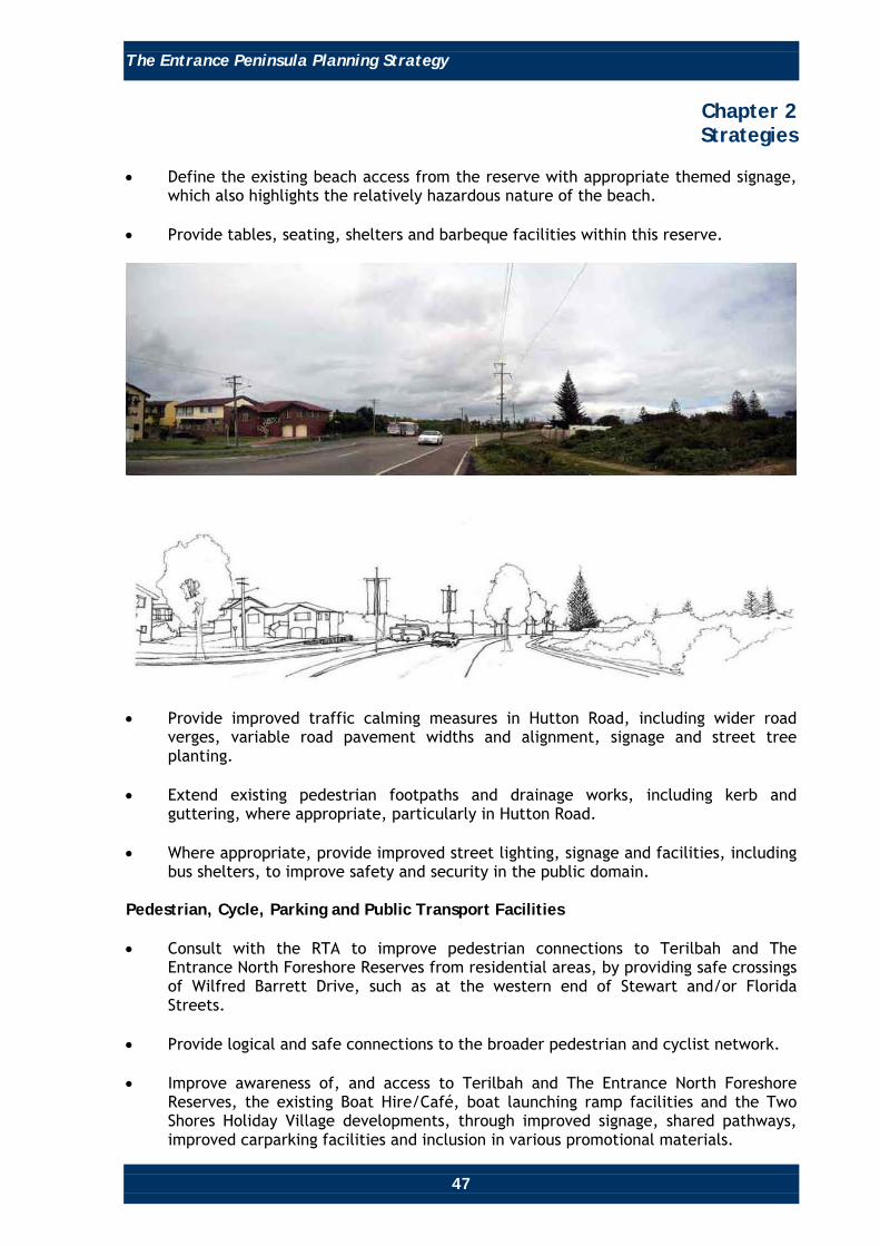
• Define the existing beach access from the reserve with appropriate themed signage,
which also highlights the relatively hazardous nature of the beach. • Provide tables, seating, shelters and barbeque facilities within this reserve.
• Provide improved traffic calming measures in Hutton Road, including wider road
verges, variable road pavement widths and alignment, signage and street tree planting.
• Extend existing pedestrian footpaths and drainage works, including kerb and
guttering, where appropriate, particularly in Hutton Road. • Where appropriate, provide improved street lighting, signage and facilities, including
bus shelters, to improve safety and security in the public domain. Pedestrian, Cycle, Parking and Public Transport Facilities • Consult with the RTA to improve pedestrian connections to Terilbah and The
Entrance North Foreshore Reserves from residential areas, by providing safe crossings of Wilfred Barrett Drive, such as at the western end of Stewart and/or Florida Streets.
• Provide logical and safe connections to the broader pedestrian and cyclist network. • Improve awareness of, and access to Terilbah and The Entrance North Foreshore
Reserves, the existing Boat Hire/Café, boat launching ramp facilities and the Two Shores Holiday Village developments, through improved signage, shared pathways, improved carparking facilities and inclusion in various promotional materials.

The Entrance Peninsula Planning Strategy
48
Chapter 2 Strategies
• Upgrade boat launching ramp, vehicle and boat trailer parking facilities in the
vicinity of the Boat Hire/Café facility. • Provide public awareness of all vehicle parking facilities and types of vehicles each
parking facility caters for via themed signage, maps and promotional materials. • Include Wilfred Barrett Drive and Hutton Road as part of a tourist circulator bus
route (if feasible). Maximise awareness of, and access to such a service, via signage, promotional materials and co-ordination between pedestrians, cyclists and public transport.
Parks and Reserves • Prepare or review Landscape Plans and Plans of Management for all public reserves
to identify the appropriateness of facilities and landscaping quality, and implement a program of works to upgrade such facilities, where necessary.
Climate Change • The entire Entrance North area is potentially susceptible to climate change impacts
(eg. sea and lake level rise, increased storm activity and intensity, and coastal erosion). Climate change issues will be addressed by incorporating appropriate planning solutions that address the latest climate change information, as it becomes available.
The Entrance Peninsula Planning Strategy
49
Chapter 2 Strategies
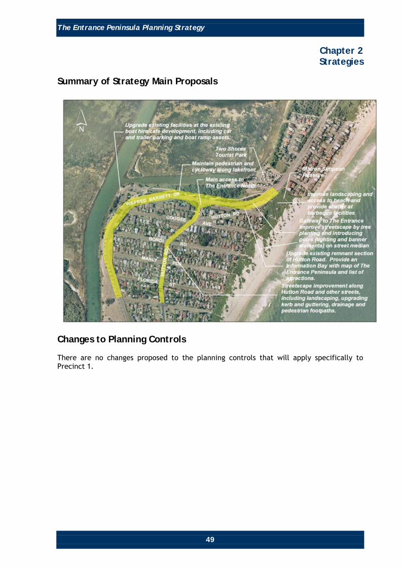
Summary of Strategy Main Proposals
Changes to Planning Controls There are no changes proposed to the planning controls that will apply specifically to Precinct 1.

The Entrance Peninsula Planning Strategy
50
Chapter 2 Strategies
Precinct 2 The Entrance North Neighbourhood Centre
Location Precinct 2 is located south of Roberts Street and extends to the tip of The Entrance North Peninsula adjacent to The Entrance Channel. It includes Karagi Reserve and Dunleith Point. Desired Future Character Precinct 2 will be a mixed use waterfront holiday, tourist, recreational and residential area, of generally low scale, that provides good awareness of its location adjacent to, and with good access to the foreshores of The Entrance Channel and the Pacific Ocean. Precinct 2 will have strong connections to other areas outside the precinct. The precinct will provide tourist and local convenience retail and commercial facilities located in a well planned and conveniently located node.

The Entrance Peninsula Planning Strategy
51
Chapter 2 Strategies
Objectives • Promote the precinct as offering a generally low scale, low density ‘coastal village’
character, atmosphere and setting. • Encourage a mix of retail and commercial facilities at the junction of Hargraves
Street and Hutton Road, including cafés and local convenience retail. • Protect existing views and vistas to, from and across The Entrance Channel and to
the Waterfront Mall and Town Centre, Tuggerah Lake and Pacific Ocean, as much as possible.
• Improve and encourage public access to waterfront areas, including The Entrance
Channel, The North Entrance Beach, Karagi Reserve and Dunleith Point. • Improve pedestrian and cycling facilities, including improved and safer links across or
under The Entrance Bridge to/from the existing pedestrian/cycleway network and access to The Entrance Channel foreshore.
• Improve the amenity and safety of facilities in existing parks and reserves. • Improve streetscapes in terms of function and amenity. • Protect the environmentally sensitive dune system. • Design with the constraints of flood and coastal hazards. • Ensure the safe passage of vehicles and cyclists/pedestrians, to the residential areas
east of Wilfred Barrett Drive and open space and recreation areas west of Wilfred Barrett Drive.
• Facilitate redevelopment of The Entrance Channel waterfront, including Dunleith
Tourist Park into an appropriate scale, high quality tourist destination. • Provide adequate vehicle parking at strategic locations within walking distance of all
main attractions within and outside the precinct. • To achieve and maintain sustainable development via social cohesion which
recognises everyone’s needs, effective protection, conservation and management of the ‘natural’ environment, biodiversity and cultural heritage, effective energy management, effective management of hazards, including those associated with sea level rise, ocean processes, flooding, acid sulphate soils and groundwater resources, prudent use of The Entrance Peninsula’s attributes and resources and the achievement and maintenance of stable levels of economic growth and employment.

The Entrance Peninsula Planning Strategy
52
Chapter 2 Strategies
Strategies and Recommendations The following lists strategies and recommendations that will apply specifically to Precinct 2, contributing to achieving the objectives for this precinct. Building and Development Control • Restrict building heights to be a maximum two storeys [ie. generally 6 metres for
residential to the top most ceiling and 7.5 metres for mixed use (retail, commercial and/or residential) developments] and encourage coastal architectural design styles in new and redeveloped buildings.
• Buildings should have a low scale coastal character, in which verandas, skillion and
gable roofs dominate. Coastal colours (eg. whites, blues, yellows, etc.) are to be used.
• Buildings fronting coastal and lakefront areas are to be orientated to take advantage
of coastal and lake views, and designed to present attractive facades that reflect the low scale coastal character of the area. Residential flat buildings are to appear as a number of individual buildings that complement the existing built forms.
• Expand the 3(a) (Business Centre) zone onto the southern side of Hargraves Street
(between Hutton Road and opposite Denniss Road) to provide for future expansion and create a more defined and integrated village centre, with opportunities for small scale retail, commercial and residential uses, awnings covering footpaths to accommodate sheltered outdoor dining, and the provision of improved linkages to The Entrance Channel foreshore, The North Entrance Beach and other areas outside Precinct 2.
• Facilitate redevelopment of the Dunleith Tourist Park that respects its waterfront
location, provides for public access along The Entrance Channel and connects to the broader pedestrian and bicycle pathway network. This site is considered to have redevelopment potential important to the future of The Entrance Peninsula.
• Council’s planning controls are to be altered to provide suitable zoning and a
conservative ‘deemed to comply’ scenario for this site, where buildings are to be a maximum height of 7.5 metres (approximately two storeys) adjacent to The Entrance Channel, stepping up to 15 metres (approximately four storeys) adjacent to Hutton Road. Appropriate setback, floor space ratio and open space requirements will also be provided.
• An option is to be investigated that encourages and facilitates innovative building
design on this site. The potential for appropriate performance criteria to be inserted into Council’s planning controls is to be investigated. Under such an initiative, applicants would be required to demonstrate, via masterplanning approaches, that innovative proposals, that do not comply with the ‘deemed to comply’ scenario, would result in comparatively superior outcomes. The performance criteria would need to cover a variety of issues, including minimum site area requirements, the protection of important view corridors, maintaining/improving general amenity, flood hazard, minimising visual impact, overshadowing and overlooking.
The Entrance Peninsula Planning Strategy
53
Chapter 2 Strategies
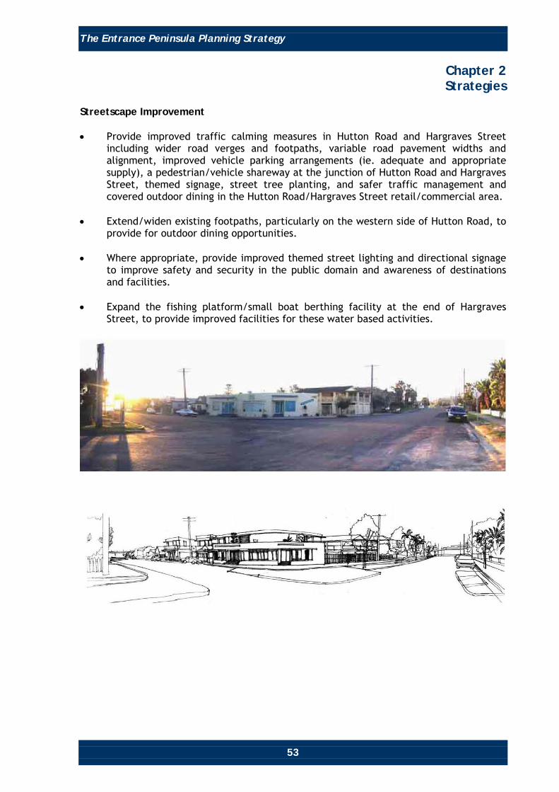
Streetscape Improvement • Provide improved traffic calming measures in Hutton Road and Hargraves Street
including wider road verges and footpaths, variable road pavement widths and alignment, improved vehicle parking arrangements (ie. adequate and appropriate supply), a pedestrian/vehicle shareway at the junction of Hutton Road and Hargraves Street, themed signage, street tree planting, and safer traffic management and covered outdoor dining in the Hutton Road/Hargraves Street retail/commercial area.
• Extend/widen existing footpaths, particularly on the western side of Hutton Road, to
provide for outdoor dining opportunities. • Where appropriate, provide improved themed street lighting and directional signage
to improve safety and security in the public domain and awareness of destinations and facilities.
• Expand the fishing platform/small boat berthing facility at the end of Hargraves
Street, to provide improved facilities for these water based activities.

The Entrance Peninsula Planning Strategy
54
Chapter 2 Strategies
Pedestrian/Bicycle and Public Transport Facilities • Complete the section of pedestrian and bicycle pathway along the western side of
Hutton Road and the southern side of Roberts Street, and improve the crossing of Wilfred Barrett Drive to link with the pedestrian/cycleway facilities in Terilbah Reserve.
• Negotiate with property owners fronting The Entrance Channel in regard to the
provision of a public continuous waterfront shared pedestrian and bicycle path that links under The Entrance Bridge to the existing pedestrian and bicycle path facilities in Terilbah Reserve and across the bridge to The Entrance Town Centre. Such a facility will improve the physical connection between the Pacific Ocean coast, The Entrance Channel and other areas outside Precinct 2, and provide a pleasant place for residents of, and visitors to, the Peninsula to enjoy.
• Improve awareness of, and access to, The Entrance Channel and North Entrance
Beach, by providing appropriate themed signage (which also highlights the relatively hazardous nature of the beach) and paving and carparking facilities on the unformed part of Hargraves Street east of Hutton Road, and at the southern end of Hutton Road.
• Include Wilfred Barrett Drive, Hutton Road and Roberts Street as part of a tourist
circulator bus route (if feasible). Maximise awareness of, and access to such a service, via signage, promotional materials and co-ordination between pedestrians, cyclists and public transport.
Parks and Reserves • Prepare or review Landscape Plans or Plans of Management for all public reserves to
identify the appropriateness of facilities and landscaping quality. • Implement a program of works to upgrade such facilities, where necessary. These
could include improvements to landscaping and park maintenance schedules to require more frequent management in the future, provision of themed interpretive and directional signage, appropriateness of playground equipment and public amenities, including the possible replacement of the public toilet block in Karagi Reserve.
Parking • Provide adequate vehicle parking at strategic locations within walking distance of all
main attractions in the precinct. • Require all future major developments to provide adequate and appropriate public
parking in line with their likely impact on parking demand. This will include providing parking for all types of vehicles including motor homes, cars and caravans, cars and trailers, buses and standard cars.
• Investigate the need to install time and allocation limitations on parking at strategic
locations to ensure accessibility to retail and tourist premises.

The Entrance Peninsula Planning Strategy
55
Chapter 2 Strategies
• Review and revise Council’s planning controls to provide clear directions concerning
the investigations required to adequately ascertain the impact of developments (that require substantial excavations for large basement components) on groundwater levels and flows, or the impacts of such levels and flows on such developments.
• Provide public awareness of all vehicle parking facilities and types of vehicles each
parking facility caters for via themed signage, maps and promotional materials. Masterplanning The Entrance Channel Vicinity • Prepare an integrated masterplan covering all lands along The Entrance Channel,
between The Entrance Bridge and Karagi Reserve. Such masterplanning will include consideration of the appropriate land use mix, connectivity between land uses, open space areas, the public domain and other areas outside Precinct 2, adequate vehicle parking and arrangements, circulation patterns (vehicle, pedestrian and cyclist) and infrastructure requirements and provision.
Climate Change • The entire Entrance North area is potentially susceptible to climate change impacts
(eg. sea and lake level rise, increased storm activity and intensity, and coastal erosion). Climate change issues will be addressed by incorporating appropriate planning solutions that address the latest climate change information as it becomes available.

The Entrance Peninsula Planning Strategy
56
Chapter 2 Strategies
Summary of Main Proposals

The Entrance Peninsula Planning Strategy
57
Chapter 2 Strategies
Changes to Planning Controls Table 2 lists the changes to planning controls that will apply specifically for Precinct 2, contributing to achieving the desired future character of The Entrance Peninsula. Table 2
Item Reference Existing Planning Control
Recommendation Justification
Zoning. WLEP 1991.
Residential 2(a) (Residential), 2(b) (Multiple Dwelling Residential), 3(a) (Business Centre), 6(a) (Open Space and Recreation) and 6(c) (Proposed Open Space and Recreation).
Expand Business Centre 3(a) (Business Centre) zone on the south side of Hargraves Street between Hutton Road and opposite Denniss Road. Rezone the Dunleith Tourist Park Site from 2(a) (Residential)/6(c) (Open Space and Recreation) to 3(d) (Tourist Business) to accommodate a high quality tourist type development.
Provides for future expansion of The Entrance North Neighbourhood Centre to provide for improved definition and integration of the centre with surrounding land uses, to better cater for local and visitor needs. Will assist amenity, function and connection to the beach and lake. Will facilitate redevelopment of the Dunleith Tourist Park Site.
Height. WLEP 1991, Clause 10. WSC DCP 2005, Chapter 60, Section 2.3.4.
Generally two storey in the 2(a) (Residential) and 2(b) (Multiple Dwelling Residential) zones. No requirements for 3(a) (Business Centre), 6(a) (Open Space and Recreation) and 6(c) (Proposed Open Space and Recreation) zones
For the Dunleith Tourist Park Site: Insert height limits of 7.5 metres (approximately two storeys) adjacent to The Entrance Channel, stepping up to 15 metres (approximately four storeys) adjacent to Hutton Road, into WLEP 1991, via height mapping.
To achieve an appropriate scale of development on The Entrance North waterfront.

The Entrance Peninsula Planning Strategy
58
Chapter 2 Strategies
Item Reference Existing Planning Control
Recommendation Justification
Height. Continued
This will represent the default (‘deemed to comply’) scenario. that could be modified, if it can be demonstrated that a higher development will provide a superior outcome. Refer ‘Alternative Innovative Planning Solutions’, below. Insert maximum height limits of 7.5 metres on the 3(a) (Business centre) zoned lands, into WLEP 1991, via height mapping.
Alternative Innovative Planning Solutions. Potential Performance Solutions.
WLEP 1991. DCP 2005, Chapter 60.
There are no performance planning criteria currently included in Council’s planning controls.
Investigate the possibility of inserting planning provisions to encourage and facilitate innovative building design on the Dunleith Tourist Park Site. Investigate the possibility of inserting appropriate performance criteria into Council’s planning controls, whereby applicants would be required to demonstrate, via masterplanning approaches, that innovative proposals, that do not comply with ‘deemed to comply’ scenarios, would result in superior outcomes/ solutions to the ‘deemed to comply’ scenarios.
To facilitate and encourage innovative high quality tourist type development solutions for the Dunleith Tourist Park.

The Entrance Peninsula Planning Strategy
59
Chapter 2 Strategies
Item Reference Existing Planning Control
Recommendation Justification
Alternative Innovative Planning Solutions. Potential Performance Solutions. Continued
The performance criteria would need to cover a variety of issues including the protection of important view corridors, general amenity, flood hazard, visual impact, overshadowing and overlooking.
Setbacks, Floor Space Ratio, Landscaping and Open Space.
WLEP 1991. DCP 2005, Chapters 60, 99.
Details various requirements relating to foreshore building lines, development near various waterbodies, general building line setbacks, floor space ratios, landscaping and open space requirements.
Review existing setback, floor space ratio, landscaping and open space requirements for the Dunleith Tourist park site and revise Council’s planning controls, as necessary, to facilitate a high quality tourist type development. The outcomes will represent the default (‘deemed to comply’) scenario (see above) that could be modified if it can be demonstrated that a higher density development will provide a superior outcome to the ‘deemed to comply’ scenario.
To facilitate a high quality tourist type development on the Dunleith Tourist Park Site.

The Entrance Peninsula Planning Strategy
60
Chapter 2 Strategies
Precinct 3 Picnic Point to Memorial Park Tourist District
Location Precinct 3 is located between Manning Road, Coral Street, Marine Parade, and the foreshore of The Entrance Channel and Tuggerah Lake. It is divided into two areas, east and west of Wilfred Barrett Drive. Desired Future Character Precinct 3 is to be a waterfront holiday, tourist and recreation destination of relatively high density, accommodating high quality retail, commercial, cultural, recreational and entertainment development/use, supported by medium to high density permanent and tourist residential development.

The Entrance Peninsula Planning Strategy
61
Chapter 2 Strategies
The precinct will offer a large variety of high quality facilities, attractions and activities (primarily relating to open space, active and passive recreation, leisure, culture and entertainment) for residents, visitors, families and people of all ages and abilities, being located beside, and having twenty-four hour access, to the foreshores of Tuggerah Lake and The Entrance Channel. Precinct 3 will have strong connections to areas outside the precinct.
Objectives • Create a high quality tourist activity destination along the Tuggerah Lake foreshore
that accommodates a viable range of retail, commercial, cultural, entertainment, tourist and recreational facilities and is supported by high quality medium to high density residential development.
• Establish a connection along the foreshore of The Entrance Channel by closing off
The Entrance Road (West) between Tuggerah Parade and Wilfred Barrett Drive to motor vehicles, to provide a promenade for recreation and entertainment use between the two recreational/entertainment areas of Memorial Park, Waterfront Mall and Picnic Point Reserve. If determined appropriate by further investigation, incorporate elements similar to those found along ‘The Strand’ at Townsville or Cairns Waterfront developments into a landscaped setting, reflecting the coastal character of The Entrance.
• Facilitate an appropriate mix of activities within the precinct. Ensure the precinct is
supported by the appropriate mix of high quality permanent residential and tourist accommodation, viable retail and commercial uses, located in suitably designed buildings. Emphasis is to be placed on attracting more commercial (office type) and speciality, unique, boutique retail type development to the area.
• Provide adequate and safe vehicle parking that does not negatively impact the
surroundings and supports the existing and future tourist, residential, retail, commercial, cultural and entertainment developments/uses in the precinct.
• Facilitate improved public transport services and facilities, including the provision of
a formal bus interchange, express bus services between The Entrance and other major centres, and a circulator bus service (if feasible).
• Ensure future development respects and maintains important views and vistas to and
from the Lake, foreshore areas and beyond. • Enhance the landscape and the public domain in terms of function and amenity to
provide an attractive destination for residents and visitors. • To achieve and maintain sustainable development via social cohesion which
recognises everyone’s need, effective protection, conservation and management of the ‘natural’ environment, biodiversity and cultural heritage, effective energy management, effective management of hazards, including those associated with sea level rise, ocean processes, flooding, acid sulphate soils and groundwater resources, prudent use of The Entrance Peninsula’s attributes and resources and the achievement and maintenance of stable levels of economic growth and employment.

The Entrance Peninsula Planning Strategy
62
Chapter 2 Strategies
Strategies and Recommendations The following lists strategies and recommendations that will apply specifically to Precinct 3, contributing to achieving the objectives for this precinct. Building and Development Control – General • Facilitate future development in the precinct that reflects its desired future
character as a high quality visitor/tourist destination, and does not detract from the amenity of the surrounding residential neighbourhood or views to and from the adjoining waterways, as much as possible.
• Provide active edges (retail and tourist uses) to future developments along The
Entrance Road (West), Tuggerah Parade, and Oakland Avenue to provide high quality, but unique, visitor/tourist attractions/services and that encourage natural surveillance and safety-by-design solutions.
• To amend Council’s planning controls by raising the maximum height limits of the
internal building envelope for the area surrounded by Bent Street, Oakland Avenue, Coral Street and Wilfred Barrett Drive from 18 metres (approximately six storeys) to 24 metres (approximately eight storeys). Such an alteration will improve the transition between the Waterfront and The Entrance Town Centre, opportunities for view sharing and provide more incentive for redevelopment of this area.
• Investigate the inclusion of appropriate maximum floor space ratio controls for the
2(g) (Residential Tourist) and 3(d) (Tourist Business) zones. Streetscape and Public Domain Improvement • In conjunction with any future application for redevelopment on the Residential
Tourist zoned lands, extend the Waterfront Mall along The Entrance Road (West) to Picnic Point, between the waters edge and property boundaries on the southern side of The Entrance Road (West), to provide for a variety of attractions, land uses, an appropriate streetscape theme and landscape treatments reflecting the coastal character of The Entrance, similar to those found in the existing Waterfront Mall and, if suitable, those found along ‘The Strand’ at Townsville or Cairns Waterfront developments.
• Improve amenity and traffic management in Oakland Avenue (between Coral Street
and The Entrance Road (West)), Bent Street and Manning Road by installing traffic calming devices to provide for safe pedestrian movement in these streets.
• Extend footpaths along the southern side of Manning Road to Tuggerah Parade and
provide footpaths in Bent Street. • Replace tables, chairs and rubbish bins along the future extended Waterfront Mall
between the existing Waterfront Mall and Picnic Point Reserve, to be consistent with those in Memorial Park and the existing Waterfront Mall.
• Incorporate suitable public art along the future Waterfront Mall extension to
facilitate cultural identity.

The Entrance Peninsula Planning Strategy
63
Chapter 2 Strategies
• If determined feasible by investigation, construct a promenade platform along lake
edge of the future Waterfront Mall extension to minimise the potential conflict between fishing, boating and other water based activities, and other uses of the future Waterfront Mall extension.
• If determined feasible by investigation, incorporate step-by-step exercise equipment
and other elements (similar to those found along ‘The Strand’ development in Townsville) along the promenade to encourage residents and visitors to visit the area and to walk, jog and otherwise exercise along the promenade, between the existing Waterfront Mall and Picnic Point, and in Picnic Point Reserve.
• Maintain adequate access to The Entrance Hotel and existing Waterfront Mall vehicle
parking facilities and maintain current parking facilities and access for delivery and maintenance vehicles, via integration in future development design of the area. Masterplanning approaches ought to be used.
Pedestrian/Cycle and Public Transport Facilities • If determined feasible by investigation, maintain and improve pedestrian and bicycle
facilities along the Tuggerah Lake waterfront between the existing waterfront mall and Picnic Point Reserve, by extending the existing pedestrian and bicycle path (currently culminating in Picnic Point Reserve) along the future waterfront mall extension, to connect with existing pathways to The Entrance Surf Club and across The Entrance Bridge. Alternatively, if determined feasible by investigation, provide pedestrian and bicycle facilities along Manning Road, Oakland Avenue, Bent and/or Coral Street, and Marine Parade to connect between the existing pedestrian and bicycle path (currently culminating in Picnic Point Reserve) and the existing pathways to The Entrance Surf Club and across The Entrance Bridge.
• Include Coral Street, Oakland Avenue, Manning Road and Tuggerah Parade as part of
a tourist circulator bus route (if feasible). Maximise awareness of, and access to such a service, via signage, promotional materials and co-ordination between pedestrians, cyclists and public transport.
• Investigate improving public transport facilities by providing a bus interchange
facility at the residential tourist zoned area, west of Wilfred Barrett Drive. Parks and Reserves • Improve landscaping (using coastal species indigenous to the area), install directional
signs and place/feature name signs of an appropriate shape and design to clarify Picnic Point Reserve’s role as a place for passive and active recreation, and environmental appreciation (eg. providing environmental interpretation plaques). Chapter 4 – Landscape and Public Domain Action Plan, provides recommendations on appropriate landscaping, scale and design of signs.
• Review the provision and appropriateness of the playground equipment (in terms of
suitability for age of users and safety) at all open space and reserve areas and if determined necessary provide/replace with suitable play equipment with adequate safety fencing (if determined necessary).

The Entrance Peninsula Planning Strategy
64
Chapter 2 Strategies
• Improve the amenity of Picnic Point Reserve and Memorial Park by introducing a
more frequent maintenance schedule in regard to physical works. • Improve surfaces, landscaping and maintenance of vehicle parking areas. • Refurbish or replace the existing public toilet facilities with more contemporary
facilities, if determined necessary or appropriate. • Incorporate environmental and heritage interpretation facilities in appropriate areas. • Incorporate active recreational activities at Picnic Point Reserve by adding and/or
improving facilities and amenities such as the skateboard ramp, a landscaped rock pool, barbeque facilities and shelters, lighting and the like.
• Continue and improve weekend markets, concerts and events in Memorial
Park/Waterfront Mall. • Upgrade the stage and buildings located in Memorial Park. Parking • Ensure provision of adequate vehicle parking facilities at strategic locations, within
walking distance of all main attractions in the precinct. • Require all future major developments to provide adequate and appropriate public
parking in line with their likely impact on parking demand. This will include providing parking for a range of types of vehicles, such as motor homes, cars and caravans, cars and trailers, tourist buses and standard cars as appropriate for the site or area.
• Investigate the need to install time and allocation limitations on parking at strategic
locations throughout The Entrance Peninsula to ensure accessibility to retail/commercial premises.
• Review and revise Council’s planning controls to provide clear directions concerning
the investigations required to adequately ascertain the impact of developments (that require substantial excavations for large basement components) on groundwater levels and flows, or the impacts of such levels and flows on such developments.
• Provide public awareness of all vehicle parking facilities and types of vehicles each
parking facility caters for via themed signage, maps and promotional materials. Climate Change • The foreshore areas of The Entrance are potentially susceptible to climate change
impacts (eg. sea and lake level rise, increased storm activity and intensity, and coastal erosion). Climate change issues will be addressed by incorporating appropriate planning solutions that address the latest climate change information as it becomes available.

The Entrance Peninsula Planning Strategy
65
Chapter 2 Strategies
General (Other Matters - also relevant to Precinct 6) • Facilitate the creation of more appropriate spaces for commercial (office type)
development by embellishing Council’s planning controls, to attract more commercial development, jobs and permanent residents within or close to the Entrance Town Centre, to assist with the long-term viability of businesses.
• Changes in relation to floor to floor height requirements for various types of
development as enunciated in the General Area Section above combined with the outcome of investigations into a minimum requirement for area of office and permanent residential spaces, and the attraction of significant tenants into the Town Centre area (particularly on the sites considered important to the evolution of The Entrance) will assist the achievement of these objectives.
• Reduce or remove the current restrictions on businesses (eg. the removal of current
limitations regarding tables and chairs and coffee barriers) and replace with high standard criteria, to assist with the clear identification of different businesses and improve the overall atmosphere and attractiveness of The Entrance Town Centre.
• Provide for significant sized conference facilities in or close to The Entrance Town
Centre, particularly on the sites considered important to the evolution of The Entrance (refer ‘Specific Sites’ below and in Precinct 6).
• Investigate providing a greater variety of (additional) attractions and activities in The
Entrance Town Centre to cater for all age groups, including:
o Growers markets. o An open air cinema. o Quality nightclub(s)/social entertainment venue(s). o More festivals (eg. music, opera, jazz). o The retention of any existing, and the creation of additional, cultural venues,
facilities and activities. o Ecotourism activities, physical fitness activities, and the like. o Weekend markets. o Permitting ‘busking’ style entertainment (eg. music, singing, magicians, novelty
acts) in the public domain. o Longer running events (eg. week long rather than just weekend).
• Encourage retail and commercial businesses to differentiate themselves as more
individual boutique/unique offering style establishments, that appeal to tourists and residents alike, particularly along the Waterfront Mall (existing and any future extensions) and along The Entrance Road in Precinct 6.

The Entrance Peninsula Planning Strategy
66
Chapter 2 Strategies
• While it is recognised that The Entrance Town Centre Management Corporation has a
number of roles, including:
o Promoting The Entrance Peninsula and its attributes, activities, events, etc. to markets both within and outside the locality and Wyong Shire.
o Employing event management expertise in The Entrance Town Centre. o Generating ideas for and organising various events, entertainment, attractions,
amenity improvement, business improvement and assistance schemes/programs.
o Improving communication and understanding of established principles and
processes between the various stakeholders. o Maintaining community assets. It is mooted that, in accordance with Council’s support for ongoing liaison with all relevant stakeholders, that Council investigate facilitating the following additional items:
o Developing comprehensive tourism strategies. o Seeking and obtaining various available grants. o Providing business coaching and/or mentoring expertise.
Specific Sites – Western Portion of Precinct 3 • The following strategies and recommendations apply specifically to sites in the
western portion of the precinct. They contribute to achieving the objectives and desired future character of Precinct 3.
The Entrance Peninsula Planning Strategy
67
Chapter 2 Strategies
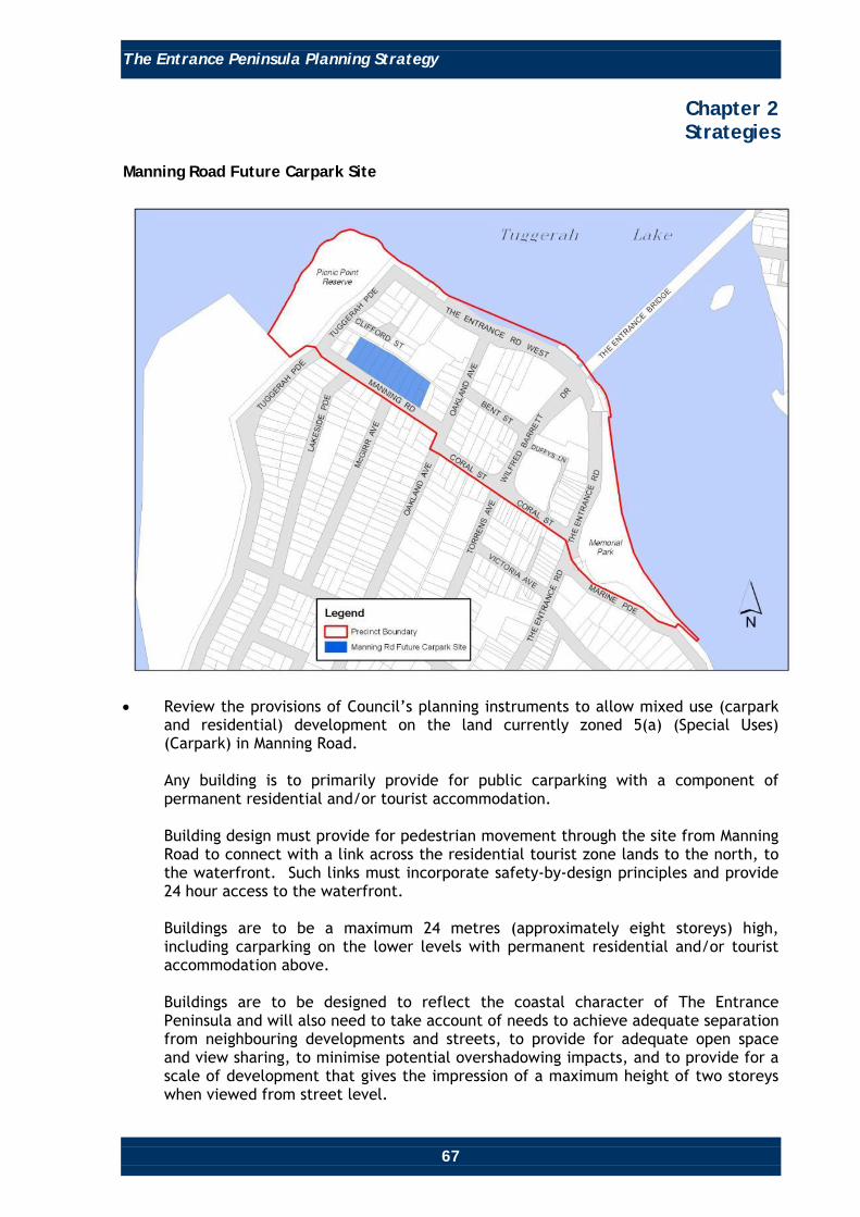
Manning Road Future Carpark Site
• Review the provisions of Council’s planning instruments to allow mixed use (carpark
and residential) development on the land currently zoned 5(a) (Special Uses) (Carpark) in Manning Road. Any building is to primarily provide for public carparking with a component of permanent residential and/or tourist accommodation. Building design must provide for pedestrian movement through the site from Manning Road to connect with a link across the residential tourist zone lands to the north, to the waterfront. Such links must incorporate safety-by-design principles and provide 24 hour access to the waterfront. Buildings are to be a maximum 24 metres (approximately eight storeys) high, including carparking on the lower levels with permanent residential and/or tourist accommodation above. Buildings are to be designed to reflect the coastal character of The Entrance Peninsula and will also need to take account of needs to achieve adequate separation from neighbouring developments and streets, to provide for adequate open space and view sharing, to minimise potential overshadowing impacts, and to provide for a scale of development that gives the impression of a maximum height of two storeys when viewed from street level.

The Entrance Peninsula Planning Strategy
68
Chapter 2 Strategies
• All development is to be orientated to, and designed to take advantage of views to
and across Lake Tuggerah. • The carpark facade should be a high quality design that addresses Manning Road and
is attractive and interesting when viewed from all perspectives. It should appear as a number of multiple residential style buildings, rather than a single building block mass.
Residential Tourist Zone Site
• To encourage development that provides for high quality mixed uses (eg. retail,
commercial, tourist facilities, permanent residential and tourist accommodation) that:
o Is a maximum 24 metres high (approximately 7 to 8 storeys) providing high
quality design, active edges along all streets, and to maximise opportunities for varying building facades.
Buildings are to be designed to reflect the coastal character of The Entrance Peninsula and will also need to take account of needs to achieve adequate separation from neighbouring developments and streets, to provide for adequate open space and view sharing, to minimise potential overshadowing impacts, and to provide for a scale of development that gives the impression of a maximum height of two storeys when viewed from street level.

The Entrance Peninsula Planning Strategy
69
Chapter 2 Strategies
o Is orientated to, and designed to take advantage of views to and across
Tuggerah Lake.
o Provides effective connections and pedestrian access between the waterfront area and the Manning Road Carpark site to the south and along Oakland Avenue. Such connections must incorporate safety-by-design principles and provide 24 hour access to the waterfront.
o Provides good visual amenity for surrounding areas, with high quality
architecture that is interesting when viewed from all perspectives.
o Amend Council’s planning controls by raising the maximum height limits for the area surrounded by Bent Street, Oakland Avenue, Coral Street and Wilfred Barrett Drive from 18 metres (approximately 5 to 6 storeys) to 24 metres (approximately 7 to 8 storeys). Such an alteration will improve the transition between the waterfront and The Entrance Town Centre, view sharing and provide more incentive for redevelopment of this area.
Buildings are to be designed to reflect the coastal character of The Entrance Peninsula and will also need to take account of needs to achieve adequate separation from neighbouring developments and streets, to provide for adequate open space and view sharing, to minimise potential overshadowing impacts, and to provide for a scale of development that gives the impression of a maximum height of two storeys when viewed from street level.
o Maintains adequate access to existing development, such as The Entrance
Hotel, and facilitates improved vehicle parking, service/delivery vehicle and tourist bus access, egress and parking.

The Entrance Peninsula Planning Strategy
70
Chapter 2 Strategies
Map 2: Manning Road Future Carpark and Residential Tourist Zone Sites - Main Proposals
o The above ‘specific site’ recommendations will form the ‘deemed to comply’ scenario for both sites.
An option is to be investigated that encourages and facilitates innovative building design on this site.
The potential for appropriate performance criteria to be inserted into Council’s planning controls is to be investigated. Under such an initiative, applicants would be required to demonstrate, via masterplanning approaches, those innovative proposals, that do not comply with ‘deemed to comply’ scenarios, would result in superior outcomes to the ‘deemed to comply’ scenarios. The performance criteria would need to cover a variety of issues, including the protection of important view corridors, maintaining/improving general amenity, minimising visual impact, overshadowing and overlooking.

The Entrance Peninsula Planning Strategy
71
Chapter 2 Strategies
Summary of Strategy Main Proposals
Changes to Planning Controls Table 3 lists the changes to planning controls that will apply specifically for Precinct 3. Such changes will contribute to achieving the objectives and desired future character of the precinct.

The Entrance Peninsula Planning Strategy
72
Chapter 2 Strategies
Table 3
Item Relevant Planning
Instrument Current Controls Recommendation Justification
Building Height and Design.
WLEP 1991. WSC DCP 2005, Chapter 60.
Clause 10 in relation to the 2(g) zone and Clause 42B(4). Clauses 2.3.4 and Part 5.
Amend Council’s planning controls by raising the maximum height limits on the existing height map of the internal building envelope for the area surrounded by Bent Street, Oakland Avenue, Coral Street and Wilfred Barrett Drive, from 18 metres to 24 metres. Insert maximum height limits of 24 metres on the 5(a) Special Use – Carparking zoned lands, into WLEP 1991, via the introduction of a height map. Insert a requirement that the specified heights can only be achieved on a parcel, or parcels, of land greater than 1,800 square metres. Provide for high quality design with active edges along all street frontages, and maximise opportunities for varying and interesting building facades.
Such an alteration will improve the transition between the Waterfront and The Entrance Town Centre, opportunities for view sharing and provide more incentive for redevelopment of this area. To achieve an appropriate scale of development for the site, while mitigating potential adverse impacts on neighbouring properties and public domain.

The Entrance Peninsula Planning Strategy
73
Chapter 2 Strategies
Item Relevant Planning
Instrument Current Controls Recommendation Justification
Building Height and Design. Continued
Investigate and develop building design criteria that reflects the coastal village character of The Entrance Town Centre and will also take account of needs to achieve adequate separation from neighbouring developments and streets, to provide for adequate open space and view sharing, to minimise potential overshadowing impacts, and to provide for a scale of development that gives the impression of a maximum height of two storeys when viewed from street level.
Alternative Innovative Planning Solutions. Potential Performance Solutions.
WLEP 1991. DCP 2005, Chapter 60.
There is no performance planning criteria currently included in Council’s planning controls.
Investigate the possibility of inserting planning provisions that encourage and facilitate innovative building design on the specific sites considered important to the evolution of The Entrance Peninsula (ie. the residential tourist zoned area and Manning Road carpark site).
To facilitate and encourage innovative development solutions on specific sites considered important to the evolution of The Entrance Peninsula.
The Entrance Peninsula Planning Strategy
74
Chapter 2 Strategies
Item Relevant Planning
Instrument Current Controls Recommendation Justification
Alternative Innovative Planning Solutions. Potential Performance Solutions. Continued
Investigate the possibility of inserting appropriate performance criteria are to be inserted into Council’s planning controls, whereby applicants would be required to demonstrate, via masterplanning approaches, that innovative proposals, that do not comply with ‘deemed to comply’ scenarios, will result in superior outcomes to the ‘deemed to comply’ scenarios. The performance criteria would need to cover a variety of issues including the protection of important view corridors, general amenity, flood hazard, visual impact, overshadowing and overlooking.
Floor Space Ratio.
WLEP 1991. DCP 2005, Chapter 60.
Currently, there are no FSR Controls for the 2(g) (Residential Tourist) and 3(d) (Tourist Business) zones.
Investigate the inclusion of appropriate maximum floor space ratio controls for the 2(g) (Residential Tourist) and 3(d) (Tourist Business) zones.
To assist in achieving the vision, objectives and desired future character of the precinct.

The Entrance Peninsula Planning Strategy
75
Chapter 2 Strategies
Precinct 4 The Entrance Channel Recreation and Residential
Location Precinct 4 is located between Marine Parade and the Pacific Ocean, and the north eastern side of Ocean Parade. Desired Future Character Precinct 4 is to be an oceanside foreshore recreational destination for residents and visitors, and a high quality low to medium density residential area, providing accommodation for permanent residents and visitors.

The Entrance Peninsula Planning Strategy
76
Chapter 2 Strategies
The Precinct will have unconstrained twenty-four hour access to The Entrance Channel and Pacific Ocean foreshore areas, facilities and attractions that will provide activities for families and people of all ages. Activities will include fishing, swimming, picnicking, wind surfing, kite flying, general leisure, recreation and view and environmental and heritage appreciation. It will be a pleasant place to live and visit with easy access to all of The Entrance Peninsula’s attributes including, views, broad range of activities/attractions, high quality built form, attractive streetscapes, high quality landscape and public art, designed to complement The Entrance Peninsula’s coastal character. Objectives • Facilitate, where the opportunity arises, an appropriate built form and scale of new
development that responds to the waterfront setting, and complements the existing low to medium density coastal character of Precinct 4.
• Maintain and enhance the amenity of, and access to facilities and activities on the
Pacific Ocean and The Entrance Channel foreshore areas. • Enhance connections, and awareness of those connections, between The Entrance
Town Centre, The Entrance Channel and Pacific Ocean foreshores, with streetscape improvements, directional signage and inclusion in promotional materials.
• Improve existing streetscapes, as necessary. • Provide for and maximise awareness of, and access to, a proposed shuttle/circulator
bus route, if feasible. • To achieve and maintain sustainable development via social cohesion which
recognises everyone’s needs, effective protection, conservation and management of the ‘natural’ environment, biodiversity and cultural heritage, effective energy management, effective management of hazards, including those associated with sea level rise, ocean processes, flooding, acid sulphate soils and groundwater resources, prudent use of The Entrance Peninsula’s attributes and resources and the achievement and maintenance of stable levels of economic growth and employment.
Strategies and Recommendations The following lists strategies and recommendations that will apply specifically to Precinct 4, contributing to achieving the objectives for this precinct. Building and Development Control • Review Council’s planning instruments to ensure sites within the precinct are zoned
to reflect the most appropriate land use.

The Entrance Peninsula Planning Strategy
77
Chapter 2 Strategies
Streetscape Improvement • Improve the streetscape and public domain in all streets in the precinct by installing,
where appropriate, additional lighting, signage, street furniture and landscaping (particularly street trees) which are of a suitable form and scale consistent with the coastal character of Precinct 4.
• Provide footpaths in streets where they are not provided to improve connections,
that link with a logical network of footpaths, and improve connections between The Entrance Town Centre and The Entrance Channel and Pacific Ocean foreshores, using attractive landscaping solutions and safety-by-design principles.
• Extend verges, narrow road pavements and provide traffic calming devices and
pedestrian crossings to promote safety and amenity, where necessary. Pedestrian/Cycle and Public Transport Facilities • Include Marine Parade and Dening Street as part of a tourist circulator bus route (if
feasible). Maximise awareness of, and access to such a service, via signage, promotional materials and co-ordination between pedestrians, cyclists and public transport.
Foreshore Recreation Area, Boardwalk and Carparking • Maintain and enhance foreshore recreation areas, including the boardwalk, by
improving landscaping using salt tolerant species, providing appropriate directional, interpretative and activity signage, and implementing a program of works to secure the amenity and safety of facilities, furniture and fencing. Refer to Chapter 4 - Landscape and Public Domain Action Plan, for further details.
• Prepare a, or review the, management plan for the foreshore reserve areas along The
Entrance Channel and Pacific Ocean in relation to remediation, landscaping, the provision of age appropriate playground equipment, and the regular improvement/replacement of place, historic and environmental interpretative information, and the boardwalk.
• Investigate providing a quality café, restaurant or kiosk in the vicinity of The
Entrance Surf Club and/or The Entrance Baths, oriented to overlook the Pacific Ocean and coastline.
Heritage • Enhance Council’s LEP and DCP 2005 provisions in regard to the protection of the
heritage significance of the building and curtilages of The Entrance Surf Lifesaving Club (listed as having local heritage significance in the WSC LEP 1991).

The Entrance Peninsula Planning Strategy
78
Chapter 2 Strategies
Climate Change • The foreshore areas of The Entrance are potentially susceptible to climate change
impacts (eg. sea and lake level rise, increased storm activity and intensity, and coastal erosion). Climate change issues will be addressed by incorporating appropriate planning solutions that address the latest climate change information as it becomes available.
Changes to Planning Controls There are no changes proposed to the planning controls that will apply specifically to Precinct 4.

The Entrance Peninsula Planning Strategy
79
Chapter 2 Strategies
Precinct 5 High Density Residential
Location Precinct 5 is bounded by Dening Street to the south, Short Street and Ambler Parade to the west, and Ocean Parade to the North and East, and is located to the east of The Entrance Town Centre. Desired Future Character Precinct 5 is to be a high density residential neighbourhood providing high levels of amenity and convenience for its residents. Its proximity to The Entrance Town Centre and foreshores of The Entrance Channel and Pacific Ocean, and the services, facilities and activities that are provided in those places, will make it a pleasant and desirable place to live. It will have a range of high quality residential buildings designed largely to accommodate permanent residents and constructed to complement The Entrance Peninsula’s coastal character.

The Entrance Peninsula Planning Strategy
80
Chapter 2 Strategies
Its public domain will include safe and attractive streets, including high quality landscaping, consistent design and treatment of facilities, including adequate and appropriate footpaths, kerb and gutter, street lighting and signage. Objectives • Provide an area of higher density, high quality, residential development to largely
accommodate permanent residential living adjacent to The Entrance Town Centre, The Entrance Channel and the Pacific Ocean.
• Enhance a sense of place and community through streetscape and public domain
improvements that reflect the coastal character of The Entrance Peninsula. • To achieve and maintain sustainable development via social cohesion which
recognises everyone’s needs, effective protection, conservation and management of the ‘natural’ environment, biodiversity and cultural heritage, effective energy management, effective management of hazards, including those associated with groundwater resources, prudent use of The Entrance Peninsula’s attributes and resources.
Strategies and Recommendations The following lists strategies and recommendations that will apply specifically to Precinct 5, contributing to achieving the objectives for this precinct. Building and Development Control • Review Council’s LEP and DCP provisions to ensure continued improvement in the
quality of new developments, and to ensure that new developments are designed to fit in with The Entrance Peninsula’s coastal character in terms of scale and streetscape impact.
• Insert height controls into Council’s planning controls to limit heights in this precinct
to a maximum 24 metres (approximately eight storeys) and 18 metres (approximately six storeys) in accordance with Map 3. Insert a requirement that the specified heights can only be achieved on a parcel, or parcels, of land with an area greater than 1,800 square metres.

The Entrance Peninsula Planning Strategy
81
Chapter 2 Strategies
Map 3: High Density Residential Zone Height Limits
Streetscape Improvement • Prepare and implement a streetscape design strategy to provide a consistent design
approach for footpaths, street tree planting, street furniture, street lighting and signage, and to reinforce Ocean Parade and Dening Street as the main thoroughfares in the precinct. Refer Chapter 4 - Landscape and Public Domain Action Plan, for ideas.
Pedestrian/Bicycle and Public Transport Facilities • Provide footpaths in streets, where they are not provided, to facilitate safe
pedestrian movement within the precinct, and to provide connections between The Entrance Town Centre, The Entrance Channel and Pacific Ocean foreshores. Footpaths should fit into a logical network of pathways.
• Include Dening Street as part of a tourist circulator bus route (if feasible). Maximise
awareness of, and access to such a service, via signage, promotional materials and co-ordination between pedestrians, cyclists and public transport.
Changes to Planning Controls Table 4 lists the only change to planning controls that will apply specifically for Precinct 5. Such a change will contribute to achieving the objectives and desired future character of the precinct.

The Entrance Peninsula Planning Strategy
82
Chapter 2 Strategies
Table 4
Item Relevant Planning
Instrument Current Controls Recommendation Justification
Building Height.
WLEP 1991. WSC DCP 2005, Chapters 60 and 64.
There are currently no height controls for Precinct 5.
Amend Council’s planning controls by inserting height limits of 24 metres and 18 metres respectively, for Precinct 5, in accordance with Map 3. Insert a requirement that the specified heights can only be achieved on a parcel, or parcels, of land greater than 1,800 square metres.
Such an alteration will assist in maintaining the coastal character of The Entrance by maintaining an appropriate scale of development, a logical transition between The Entrance Town Centre and foreshore areas, accommodate view sharing, and provide for sufficient permanent residential densities adjacent to, and to support the viability of The Entrance Town Centre.