chapter 2 surveys, geophysical methods, soil core sampling
TRANSCRIPT

1
Chapter 2 Surveys, Geophysical Methods, Soil Core Sampling, and Shovel Test Pits
Anna S. Agbe-Davies Researchers at New Philadelphia use a variety of techniques to discover and assess the potential of archaeological deposits. Geophysical survey has been a key technique for identifying likely areas for intensive excavation, as have shovel test pit surveys and soil coring. These strategies were deployed in the following ways during the 2010 season:
a. Electrical resistivity and magnetic gradiometry were applied to Block 12, the first geophysical surveys of this portion of the site.
b. A portion of Block 13 was surveyed using ground penetrating radar and electrical resistivity.
c. Excavators used a 1 in. soil corer to test geophysical anomalies on Blocks 4 and 13. One of these areas was selected for follow-up excavation.
d. Electrical resistivity was applied to grids on Block 11. Follow-up work took the form of shovel test pits.
e. Excavators used a hammer-driven 2 in. corer to test thermal anomalies identified in the 2008 low-aerial survey, on Block 7, Lots 7 and 8, as well as two areas between blocks: King Street between Block 4, Lot 8 and Block 7, Lot 1; and Ann Street, on the eastern edge of Block 8, Lot.
f. Excavators also undertook core sampling and targeted excavation at the northern edge of the east-most of the west side terraces, where large-bore core sampling in 2008 revealed intact stratigraphic profiles.
Items “a” through “d” are discussed in this chapter as methods for identifying features for excavation. Items “e” through “f” are dealt with in Chapter 6, which focuses on geoarchaeology specifically.
Geophysical surveys Major geophysical surveys of the New Philadelphia town site took place from 2004 to 2006, with some additional data collected in 2008. In 2010, Carl Carlson-Drexler from the U.S. Army Engineer Research and Development Center, Construction Engineering Research Laboratory, Champaign, came to do additional data collection and provide instruction for the students participating in the NSF-REU program. All of the information reported in this “Geophysical survey” section refers to personal communication with Carlson-Drexler (2010). Carlson-Drexler supervised the use of electrical resistivity in four 20 x 20 m. data collection grids and conducted a magnetic gradiometry survey of three 20 x 20 m. grids. Ground penetrating radar was used on two 20 x 20 m. grids.
2
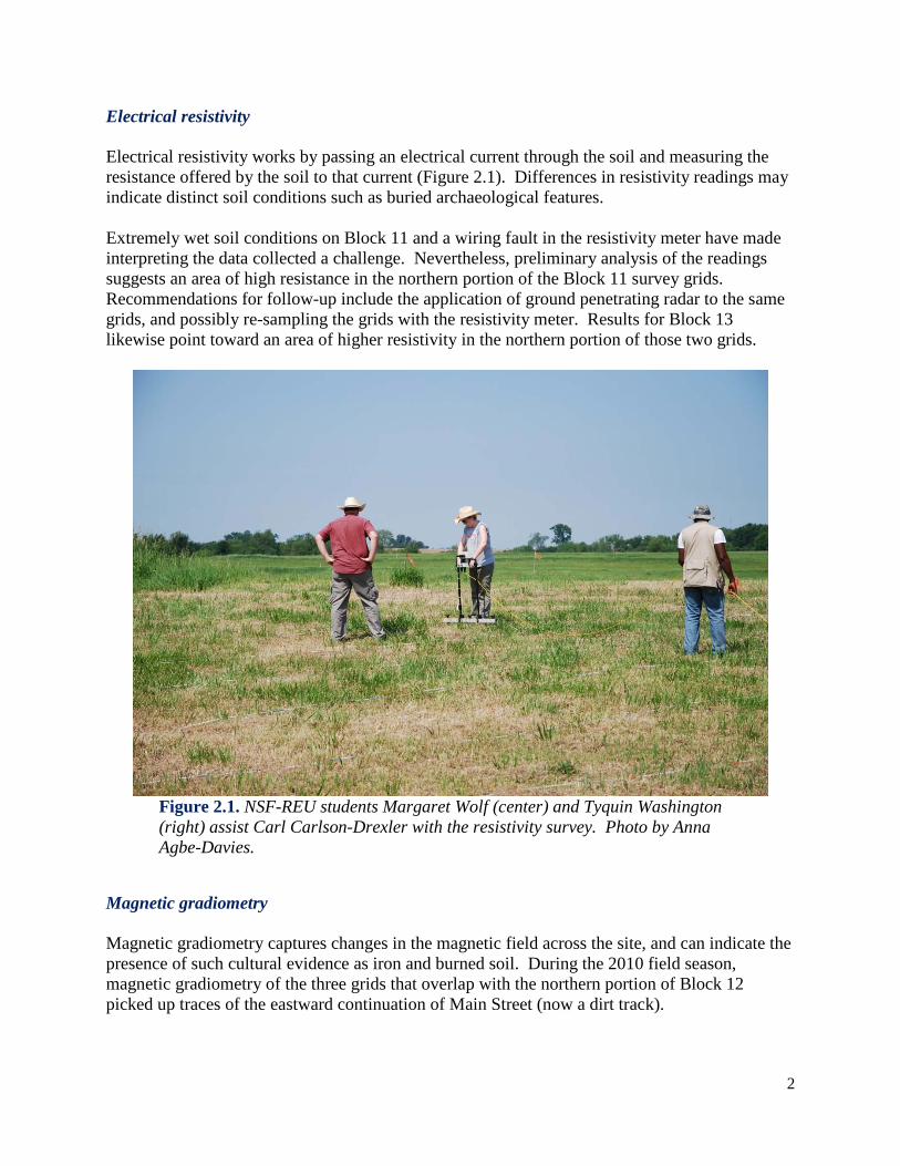
Electrical resistivity Electrical resistivity works by passing an electrical current through the soil and measuring the resistance offered by the soil to that current (Figure 2.1). Differences in resistivity readings may indicate distinct soil conditions such as buried archaeological features. Extremely wet soil conditions on Block 11 and a wiring fault in the resistivity meter have made interpreting the data collected a challenge. Nevertheless, preliminary analysis of the readings suggests an area of high resistance in the northern portion of the Block 11 survey grids. Recommendations for follow-up include the application of ground penetrating radar to the same grids, and possibly re-sampling the grids with the resistivity meter. Results for Block 13 likewise point toward an area of higher resistivity in the northern portion of those two grids.
Figure 2.1. NSF-REU students Margaret Wolf (center) and Tyquin Washington (right) assist Carl Carlson-Drexler with the resistivity survey. Photo by Anna Agbe-Davies.
Magnetic gradiometry Magnetic gradiometry captures changes in the magnetic field across the site, and can indicate the presence of such cultural evidence as iron and burned soil. During the 2010 field season, magnetic gradiometry of the three grids that overlap with the northern portion of Block 12 picked up traces of the eastward continuation of Main Street (now a dirt track).

3
This technique also revealed several large dipoles, or readings with both a high and a low signature -- typical of small iron artifacts -- in the eastern grid. Two “significant” dipoles appeared in the northernmost of the grids (Carlson-Drexler, personal communication 2010) indicating a probable anomaly on Block 9. No anomalies appeared in the areas of interest (Lots 4 and 3) as determined by prior shovel test pit surveys (Fennell 2006).
Ground penetrating radar Ground penetrating radar works by sending pulses of electromagnetic energy into the ground and measuring the varying rates at which the waves are reflected back to the surface. The ground penetrating radar data collected from Block 13 was heavily impacted by the plow furrows still apparent on the ground surface. This is true even for data collected at 1.5 meters below the surface. Recommendations for future use include running the machine parallel to the furrows, as opposed to across them, and testing the method elsewhere at the site (Carlson-Drexler, personal communication 2010). This season marked the first use of ground penetrating radar on the town site,
Coring Archaeologists selected several anomalies further testing that had been identified by geophysics surveys conducted 2004-2008. These anomalies were tested with transects across them at 1 ft. intervals using a 1 in. probe (Figure 2.2). The areas tested include Anomaly A57 on Block 4, Lot 8, Anomaly A58, on Block 4, Lot 7, and Anomaly A21, on Block 13, Lot 3.
Figure 2.2. Members of Team X assess the sediments recovered when using an Oakfield probe to survey Block 8. Photo by Anna Agbe-Davies.
4
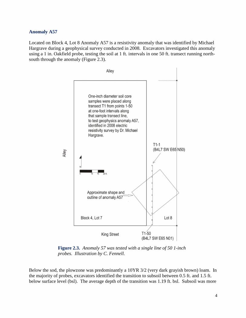
Anomaly A57 Located on Block 4, Lot 8 Anomaly A57 is a resistivity anomaly that was identified by Michael Hargrave during a geophysical survey conducted in 2008. Excavators investigated this anomaly using a 1 in. Oakfield probe, testing the soil at 1 ft. intervals in one 50 ft. transect running north-south through the anomaly (Figure 2.3).
Figure 2.3. Anomaly 57 was tested with a single line of 50 1-inch probes. Illustration by C. Fennell.
Below the sod, the plowzone was predominantly a 10YR 3/2 (very dark grayish brown) loam. In the majority of probes, excavators identified the transition to subsoil between 0.5 ft. and 1.5 ft. below surface level (bsl). The average depth of the transition was 1.19 ft. bsl. Subsoil was more

5
variable in color, but tended to be recorded as 10YR 6/6 (brownish yellow) to 10YR 5/4 (yellowish brown) clay loams or loamy clays (precise details about each core can be found in Chapter 9: Unit/Feature Summaries). A notable exception to the above pattern was found at the approximate center of the survey area. Probes 21, 22, and 23 all indicate darker loams and sandy loams at much greater depths than the rest of the transect. Each of the probes sampled a depth greater than 2.5 ft. and none of them recovered the yellowish clayey soils typical of sterile subsoil at the town site. Instead, excavators reported darker brown sediments, sometimes intermixed with the more yellow clays. The grid coordinates are
• Probe 21: B4L7 SW E65 N30 • Probe 22: B4L7 SW E65 N29 • Probe 23: B4L7 SW E65 N28
The average depth of the transition to subsoil excluding these anomalous probes is 1.09 ft. bsl. Future testing should focus on this portion of Block 4, Lot 7, to determine if the unusual soil profiles in Probes 21-23 indicate a cultural, rather than natural, feature and to ascertain the relationship between that disturbance and the anomaly detected by resistivity in 2008.
Anomaly A58 Anomaly A58 is a resistivity anomaly that was identified by Michael Hargrave in a geophysical survey conducted in 2008. Excavators placed a single transect north to south through the center of the anomaly using a 1 in. Oakfield probe. The transect line is 30 ft. east of the western edge of Block 4, Lot 7. It runs from a point 65 ft. north of the southwest corner of the lot, to a point 47 north of the corner (Figure 2.4). The cores in this location indicated a much thinner plowzone than the survey area further to the west around Anomaly A57. The plowzone may be characterized as a 10YR 3/2 to 10YR 4/2 (very dark to dark grayish brown) silt loam. The subsoil is a 10YR 4/6 to 10YR 5/6 (dark to yellowish brown) clay loam. The average depth of the transition between plowzone and subsoil is 0.69 ft. bsl. However, notable exceptions occurred in probes 1, 2, 10, and 17, with depths in excess of 1 ft. Excluding these probes, the average depth was more like 0.51 ft. bsl. In addition to revealing darker soils at unusual depths, probes 1 and 2 both show interspersed dark grayish brown loams and yellowish brown clays. This disruption of the natural stratigraphic progression in this portion of the site may merit further investigation. Undisturbed subsoil does not appear until 2.11 ft. bsl in probe 1. Another important distinction to note is the unusually loose sediments in probes 14, 16, and 17. Field notes also indicate that the darker sediments continue to a noticeably greater depth in probes 16 (0.67 ft.) and 17 (1.15 ft.). Excavators tested to either side (east and west) of probes 14 and 16 and found similarly lightly-packed sediments. All of these indicators suggest that additional excavation to explore Anomaly A58 should focus on the following areas:

6
• Probe 14: B4L7 SW E30 N52 • Probe 16: B4L7 SW E30 N50 • Probe 17: B4L7 SW E30 N49
As well as possibly exploring • Probe 1: B4L7 SW E30 N65 • Probe 2: B4L7 SW E30 N64
Figure 2.4. Anomaly 58 was tested with a single line of 19 1-inch probes. Illustration by C. Fennell.

7
Both A57 and A58 were considered low probability anomalies, because they were identified only with resistivity, and had no accompanying magnetic signature (Hargrave, personal communication 2008). However, both seem to be identifiable archaeologically. The question remains whether the anomalies are cultural, and whether they date to a period of interest.
Anomaly A21 Geophysicist Michael Hargrave identified Anomaly A21 on Block 13, Lot 3 during a resistivity survey conducted in 2004. In his report, he characterizes it as a “trench-like high resistance
Figure 2.5. Anomaly 21 was tested with four lines of 10 1-inch probes. Illustration by C. Fennell.
anomaly” with a north south orientation that would be consistent with a structure (Hargrave 2006). In 2010, a team of excavators ran four transects across the anomaly, with 10 probes in

8
each transect, for a total of 40 probes. Each of the transects ran east to west from a point 47 ft. east of the western edge of Block 13, Lot 3 to a point 56 ft. east of the edge of the lot (Figure 2.5). Transect T-1 is 19 ft. north of the southern boundary of the lot; T-2 is 20 ft. north; T-3 is 26 ft. north; and T-4 is 27 ft. north. Plowzone in this portion of the town site may be characterized as a 7.5 YR 3/2 (dark brown) clay loam. Transition to subsoil is typically 1.6 ft. bsl. The subsoil ranges from a 7.5YR 3/3 to a 7.5YR 4/4 (dark brown to brown) clay. The most promising probes for pinpointing the likely source of Anomaly A21 are • Probe T-1 6: B13L3 SW N19 E52 • Probe T-1 7: B13L3 SW N19 E53 Probe T-1 6 was blocked by a solid obstruction at 0.9 ft. bsl, while T-1 7 contained darker brown loamy soils to a depth of 2 ft. bsl. Further excavation attempting to establish the nature of Anomaly A21 should focus in this area.
Anomaly A25 Excavators also initiated a probe survey in the vicinity of Anomaly A25. This effort was successful in identifying the source of the anomaly and was excavated during the 2010 season. Results are reported in Chapter 4: Research on Block 13.
Shovel test pit survey
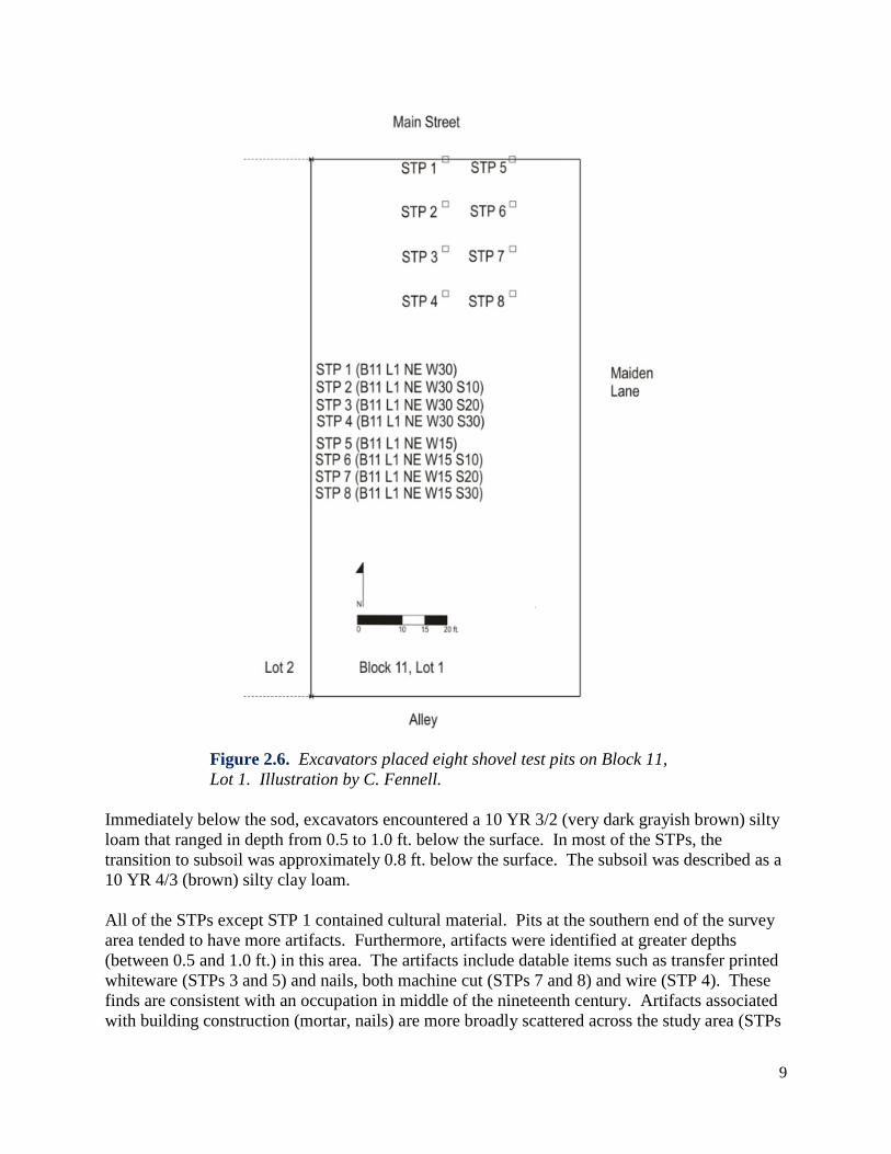
Block 11, Lot 1 Following the geophysical survey, a select area of Block 11 was investigated using shovel test pits (STPs). These STPs were excavated by volunteers from the Illinois Natural Resources Conservation Service, led by NRCS archaeologist Sharron Santure. Eight STPs were placed in the northeast corner of Block 11, Lot 1. Two transects ran north-south 15 ft. apart, with STPs at 10 ft. intervals (Figure 2.6). Each STP was 1 ft. in diameter. Excavators removed the sediment in arbitrary levels of 0.5 ft. each, while still noting color and texture distinctions as visible in the side walls of the STPs. Sediments were excavated with shovels and hand trowels and screened through quarter-inch hardware mesh to recover cultural material. The summaries for these STPs may be found in Chapter 9: Unit/Feature Summaries.
9
Figure 2.6. Excavators placed eight shovel test pits on Block 11, Lot 1. Illustration by C. Fennell.
Immediately below the sod, excavators encountered a 10 YR 3/2 (very dark grayish brown) silty loam that ranged in depth from 0.5 to 1.0 ft. below the surface. In most of the STPs, the transition to subsoil was approximately 0.8 ft. below the surface. The subsoil was described as a 10 YR 4/3 (brown) silty clay loam. All of the STPs except STP 1 contained cultural material. Pits at the southern end of the survey area tended to have more artifacts. Furthermore, artifacts were identified at greater depths (between 0.5 and 1.0 ft.) in this area. The artifacts include datable items such as transfer printed whiteware (STPs 3 and 5) and nails, both machine cut (STPs 7 and 8) and wire (STP 4). These finds are consistent with an occupation in middle of the nineteenth century. Artifacts associated with building construction (mortar, nails) are more broadly scattered across the study area (STPs

10
2, 3, 4, 7, and 8), while household artifacts cluster in the southern portion of the study area, with one exception (STPs 3, 4, 5, and 8). These preliminary results suggest that further shovel testing on Block 11, Lot 1 may be productive and could help pinpoint the location of archaeological features related to the lot’s nineteenth century owners and occupants.
History Block 11, Lot 1 Block 11, Lot 1 was only a part of the town of New Philadelphia for a short while, but had a variety of owners in the years between its initial sale by Frank McWorter and his wife (1842), and its eventual removal from the town proper (1885). Several of these individuals are fairly well documented, both in town records, and in other histories of the region. Frank McWorter sold Lot 1, along with the adjoining Lot 2, to William Bennett in 1842. Bennett in turn sold the two lots to an “Ebinezer” Franklin in 1844. The 1845 Tax Assessor’s Book for Pike County valued the lots at $10.00 each, which is more than unimproved lots ($1.00-$2.00), but nevertheless not as high as the other improved lots in town ($25.00). Neither Bennett1 nor Franklin2
appears in the census records for Hadley Township. Project historian Claire Fuller Martin estimates New Philadelphia’s population at that point to be approximately 18 people (Martin 2010a), so it is unsurprising that neither Bennett nor Franklin appeared to be in residence on the lot at that time.
Franklin and his wife conveyed Lot 2 to Elijah Thomas in a year that remains unrecorded, but clearly sometime after 1844. Suffice to say that by 1849, Thomas and his wife had sold both lots to Erastus Clark. The surname Clark is one of long standing in New Philadelphia, though they do not appear to be related to the Erastus Clarks (“white” New Yorkers), who lived and farmed in a different part of the township.3
Most of the New Philadelphia Clarks are identified as “black” or “mulatto” and are descended from migrants from Kentucky (Martin 2010a).
In February of 1851, the lots were sold by Erastus Clark and his wife to James E. Wilson, who in August of that same year sold them to Peleg Hadsell. The Hadsell family is also central to the development of New Philadelphia. In the 1850 census, we find the household of Adam Hadsell. The 1860 census lists Peleg Hadsell as head of a household in the township, but probably not in New Philadelphia proper. At some point between 1851 and 1853, the lots passed from Hadsell to Spaulding Burdick, as he was assessed for them in 1853 and 1854, by the Pike County Tax Collector. The lots appear to have retained minor improvements, as they are each valued at $20.00, in a year when
1. Though in the 1860 federal census, a Bennett household, headed by 42-year-old Francis does appear. 2. The History of Pike County, Illinois credits Ebenezer Franklin as the “first settler” of Pike County (Charles Chapman and Co. 1880 [2006]). 3. The 1850 census includes the household of “Casiah” (Kezia) Clark.

11
unimproved lots were valued between $2.00 and $5.00. The Burdicks are yet another key New Philadelphia family. “Spalder Berdick” (Spaulding Burdick) and his wife Ann (63 and 55, respectively) lived in the town in 1850, along with two minor children, John (14) and Benjamin (9). The elder Burdicks had been born in Rhode Island and Massachusetts, while the boys were born in New York. The only occupation listed is for Spaulding, who was a shoemaker. The entire family is classified as “white.” The value of their real estate holdings was $150.00. That household was reduced to two members by the time of the Illinois census of 1855. The value of their livestock was $35.00. Spaulding and Ann Burdick sold Lots 1 and 2 to Josephus Turpin in 1855, in time for him to be assessed for them by the Pike County Tax Collector in that year. Lot 1 is valued at $8.00, which was typical for unimproved lots. The Illinois census also includes the Turpin household, with three members, and livestock valued at $15.00. It was one of four “black” households in town. Marriage records indicate that Josephus Turpin had married a woman named Eliza Brown in 1848. It is likely that the other two members of the household were Eliza, and perhaps their child. Their family does not appear in any U.S. Census from 1850 to 1900 (Martin 2010b), but Turpin’s military records allow us to estimate that he was around 36 at the time he purchased the lots on Block 11. Turpin was assessed in 1856 and 1857 at rates that suggests the lots were unimproved. By 1859, Turpin was no longer the owner. Something is known of Turpin’s life after he left New Philadelphia. He enlisted with Company A of the 29th U.S. Colored Infantry (Connecticut) and was mustered in April of 1864. He gave his place of residence as Quincy, Illinois, a city about 35 miles northwest of New Philadelphia. He gave his civilian occupation as an engineer, and rose to the rank of sergeant by 1865. His service ended when he failed to return to duty following a furlough, shortly after the end of the Civil War. This act was classified as a desertion, and rendered him ineligible for a pension (Miller 1998:19, 150-151). He died in 1891, and was buried in Muscatine, Iowa. In 1859, Block 11, Lot 1 was assessed to J. Kellum, who likely lived elsewhere in town. He appeared in the 1855 Illinois census as the “white” head of a household of three, with livestock worth $320.00. He is not in the 1860 U.S. Census. The Pike County Tax Collector’s Book for 1862 lists Solomon McWorter as the man responsible for the assessments for all of the lots on Block 11. However, the notations for Lots 3-8 indicate that he was acting in his capacity as administrator for his father’s estate, whereas he appears to have owned Lots 1 and 2 outright. In 1863, Lot 1 was assessed to “Lewis” McWorter.4
But in 1864, the lots were again attributed to Solomon McWorter. In all of these cases, the lots appear by their value to be unimproved, as was true of the 1867, 1868, and 1869 Hadley Township Tax Assessor’s Book. Solomon McWorter was never in residence on this lot.
Ownership of Block 11, Lot 1 is murky for the years 1868 to 1870. As early as 1868, R. M. Atkinson, a lawyer residing in Pittsfield, was associated with the lot, having been granted Lots 1 and 2 by the Sheriff in December of that year. Nevertheless, it appears that Solomon McWorter paid the taxes in 1869. McWorter was identified as the official owner in the Pike County Tax 4. Perhaps an error and should read “Louisa” McWorter?

12
Collector’s Book for 1870, but Atkinson paid the taxes in that year. It may be that Atkinson was acting as an agent for McWorter, or that he temporarily held the title pending payment of taxes by McWorter (Claire Fuller Martin, personal communication, 2010) Another confounding entry in the deed index shows McWorter acquiring the lots from Peleg Hadsell in 1870. Throughout this period, the lots appear to be unimproved. By 1875, Solomon McWorter was again in control of all of Block 11, according to the Hadley Township Tax Assessor’s Book. The value of Lots 1 and 2, combined, $20.00, suggests that they remained unimproved. The 1878 Book values the two lots at a combined $10.00, again suggesting that they were unimproved. The 1880 Pike County Tax Collector’s Book assessed “S. McWater” for Block 11 in its entirety, though McWorter had died the previous year, and it was really his estate that owed the tax. The Hadley Township Tax Assessor’s Book for 1883 assessed Ansel Vond for all of Block 11. Vond was the husband of Solomon’s sister Lucy Ann, and it is likely that she was in fact the true owner of the lots (Martin 2010b). In the 1870 census, he appears as “Anson” Vond, and is not a town resident. They and all of their children were classified as “white.” In the 1880 census, Ansel “Vaun” is listed as a 51 year old farmer, Lucy (55) was keeping house. Their children included 19-year-old daughter Lucy, son George E. (17), and daughter Francis N. (12). All of the family members were classified as “mulatto.” George had attended school that year, and described as a laborer. Lucy and Francis were “at home.” The elder Lucy had been born in Kentucky, after the emancipation of her mother. Ansel was born in New York, as was his son. The girls were born in Illinois. They lived in the township, but not in New Philadelphia, and certainly not on Lot 1 of Block 11. In 1885 all of Block 11 was vacated on the tax rolls, effectively removing it from the town of New Philadelphia. This process also applied to Blocks 1, 10, 11, and 20, as well as the eastern halves of blocks 2, 9, 12, and 19. In summary, Lot 1 of Block 11 was at the edge of town in New Philadelphia. It passed through the hands of some of the key families in the town’s development and growth. It appears to have had improvements of some kind during its early years in the town, but from about 1862 onward, was unimproved land that was by 1885 excluded from the town proper. Table 2.1. Deed index for Block 11, Lot 1 DATE of transaction
DATE recorded
SELLER LAST
FIRST PURCHASER LAST
FIRST
1842 1845 McWorter Frank Bennett William 1844 1845 Bennett William Franklin Ebinezer 1849 1851 Thomas Elijah Clark Erastus 1851 1851 Clark Erastus Wilson James 1851 1851 Wilson James Hadsell Peleg 1855 1855 Burdick Spaulding Turpin Josephus 1870 1870 Hadsell Peleg McWorter Solomon 1868 1868 Sheriff Atkinson Richard

13
Table 2.2. Tax records for Block 11, Lot 1 Agency Year Name Assessed Owner Lot(s) Unimproved Improved Value of
Lot 1 Pike Co. Tax Collector 1845 - - 1, 2 - $20.00 $10.00 Pike Co. Tax Collector 1853 Spaulding Burdick - 1, 2 - $40.00 $20.00 Pike Co. Tax Collector 1854 Spaulding Burdick - 1, 2 - $40.00 $20.00 Pike Co. Tax Collector 1855 Josephus Turpin - 1 - $8.00 $8.00 Pike Co. Tax Collector 1856 Josephus Turpin - 1 - $8.00 $8.00 Pike Co. Tax Collector 1857 Josephus Turpin - 1, 2 $10.00 - $5.00 Pike Co. Tax Collector 1859 J. Kellum - 1, 2 $8.00 - $4.00 Pike Co. Tax Collector 1861 Solomon McWorter,
Administrator - 1, 2 $6.00 - $3.00
Pike Co. Tax Collector 1862 Solomon McWorter - 1, 2 $6.00 - $3.00 Pike Co. Tax Collector 1863 Lewis McWorter - 1, 2 $6.00 - $3.00 Pike Co. Tax Collector 1864 Solomon McWorter - 1, 2 + Block 10 $34.00 $3.40 Hadley Twp. Tax Assessor 1867 [Solomon
McWorter?] - 1, 2 $4.00 $2.00
Hadley Twp. Tax Assessor 1868 [Solomon McWorter?]
- 1, 2 $10.00 $5.00
Hadley Twp. Tax Assessor 1869 [S. McWorter?] - 1, 2 $10.00 $5.00 Pike Co. Tax Collector 1870 R.M. Atkinson Solomon
McWorter 1, 2 $3.00 $1.50
Hadley Twp. Tax Assessor 1870 R.M. Atkinson - 1, 2 $5.00 $2.50 Pike Co. Tax Collector 1872 R.M. Atkinson - 1, 2 $5.00 $2.50 Hadley Twp. Tax Assessor 1872 R.M. Atkinson - 1, 2 $5.00 $2.50 Hadley Twp. Tax Assessor 1875 Solomon McWorter - 1, 2 $20.00 $10.00 Hadley Twp. Tax Assessor 1878 S. McWorter - 1, 2 $10.00 $5.00 Pike Co. Tax Collector 1880 S. McWater - Block 11 $40.00 $5.00 Hadley Twp. Tax Assessor 1883 Ansel Vond - Block 11 $75.00 $9.38

14
Tables 2.3-2.7. Census data for owners of Block 11, Lot 1, 1850-1880. 1850 United States Name First Age Sex Color Occupation Real
Estate Place of Birth School
Berdick Spaulder 63 M W shoemaker 150 RI Berdick Ann 55 F W 0 MA Berdick John 14 M W 0 NY yes Berdick Benjamin 9 M W 0 NY yes 1855 Illinois Name First Color Number in
House Value of Livestock
Burdick Spaulding W 2 55 Turpin Josephus N/M 3 15 1860 United States Name First Age Sex Color Occupation Real
Estate Personal Property Place of
Birth School
Hadsell Peleg 38 M W farmer 600 250 NY Hadsell Margaret 38 F W housework 0 0 NY Hadsell Almon 15 M W 0 0 NY yes Hadsell Alberto 13 M W 0 0 IL yes

15
1870 United States Name First Age Sex Color Occupation Real Estate
Value Personal Property Value
Place of Birth
School
Hadsell Peleg* 52 M W farmer 1000 150 NY Hadsell Margaret 48 F W keeps house 0 0 NY Hadsell Almond 25 M W farm hand 0 0 IL Hadsell Nathan 23 M W farm hand 0 0 NY Vond Anson 40 M W farmer 4000 600 NY Vond Lucy 44 F W keeping
house 0 0 IL [sic]
Vond Mary 11 F W 0 0 IL yes Vond Lucy 9 F W 0 0 IL yes Vond George 7 M W 0 0 NY yes Vond Lucretia 5 F W 0 0 IL yes Vond Francis 3 M W 0 0 IL * NB: there is an error in the 1870 census, wherein Peleg Hadsell and P.G. Hadsell's households are confused. The family members presented in this table were listed under P.G.'s Hadsell's name. 1880 United States Name First Color Sex Age Relation Marital Occupation Origin School Vaun Ansel M M 51 - M farmer NY Vaun Lucy M F 55 wife M keeping house KY Vaun Lucy M F 19 daughter M at home IL Vaun George E. M M 17 son M laborer NY yes Vaun Francis N. M F 12 daughter M at home IL

16
[Last updated: May 12, 2011] Return to 2010 Archaeology Report Menu