chapter 2 - the sea floor
TRANSCRIPT

CHAPTER 2THE SEA FLOOR


about 4.6 billion years old Geology: the science that deals with the
dynamics and physical history of the earth, the rocks of which it is composed, and the physical, chemical, and biological changes that the earth has undergone or is undergoing
The earth is…

In most cases we will discuss geology in terms of habitats, the places in which organisms live
Geology

Oceans cover 72% of the globe and 80% of that is still considered undiscovered◦ 2/3 of the earth’s land mass is in the Northern
Hemisphere, which is only 61% ocean◦ 80% of the Southern Hemisphere is ocean
Oceans

The Geography of Ocean Basins

1. Pacific - Largest and deepest◦ almost as large as the
other 3 combined 2. Atlantic - Second
largest◦ similar to Indian in avg.
depth 3. Indian - Third largest
◦ similar to Atlantic in avg. depth
4. Arctic - Smallest and shallowest
Ocean Basins

All four basins are connected This connection is most obvious when the
world is viewed form the south pole ◦ Fig 2.2
Ocean Basins

Oceanographers often speak of one world ocean
World Ocean: Refers to the continuous body of water that surrounds Antarctica as the Southern Ocean
Ocean Basins


The Earth and our solar system is thought to have originated about 4.6 billion years ago from clouds or clouds of dust.
Big Bang: A great cosmic explosion that is
estimated to have occurred 13.7 billion years ago in which dust particles collided with each other merging into larger particles that again collided with each other eventually building up the earth and other planets
Earth Structure

Density: the mass of a given volume of a substance; Mass/Volume
When the Earth was formed it was most likely molten◦ This allowed the
interior of the Earth to form based on density Fig 2.3
Earth Structure


Core: Innermost layer of the Earth that is composed mainly of iron◦ Pressure at the core is more than a million times
the pressure on the Earth’s surface◦ Made up of a solid inner core and a liquid outer
core◦ It is thought that the swirling motions of the liquid
material in the iron-rich outer core produce the earth’s magnetic field
Internal Earth Structure

Mantle: The layer outside the earth’s core◦ most of it is
thought to be solid, but very hot - near the point of melting rock
◦ much of the mantle slowly flows almost like liquid
Internal Earth Structure
Lithosphere: The fairly rigid layer of the earth’s surface composed of the crust and upper-most part of the mantle.◦ About 100 km (60 mi) thick◦ Means “rock sphere”◦ Broken up into a number of plates called
lithospheric plates Lithospheric Plates: A part of the lithosphere
that can contain continental crust, oceanic crust, or both
Internal Earth Structure


Asthenosphere: The denser, more plastic layer of the upper mantle on which the lithosphere floats
The distinction between the lithosphere and the asthenosphere is based on how easily the rock flows
Internal Earth Structure
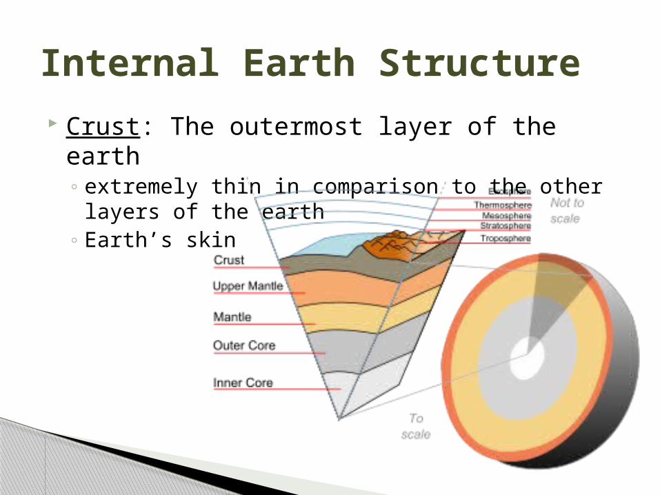
Crust: The outermost layer of the earth◦ extremely thin in comparison to the other layers
of the earth◦ Earth’s skin
Internal Earth Structure


The geological distinction between ocean and continents results from physical and chemical differences in the rock that makes up the crust
Earth’s Crust

Oceanic crust: The earth’s crust that makes up the sea floor, generally made up of the mineral basalt◦ Denser than
continental crust◦ Thinner than
continental crust
Oceanic Crust

Continental crust: The earth’s crust that makes up the land portions of the world, most continental rocks are made of granite◦ Older than the oceanic crust
Continental Crust

Origin and Structure of Ocean Basins
There is constant geological change

Sir Francis Bacon ◦ noted that the coasts of the continents on
opposite sides of the Atlantic fit together like pieces of a giant puzzle
◦ Evidence in coal deposits, geological formations, and fossil findings
Early Evidence of Continental Drift

Alfred Wegener◦ German geophysicist◦ proposed the first
detailed hypothesis of continental drift in 1912
◦ suggested that all the continents had once been a single “supercontinent” he named Pangaea biggest obstacle was his
inability to explain how this had occurred
Early Evidence of Continental Drift

Continental drift: The movement of continental masses on the surface of the earth
Continental Drift

Pangaea: The single large landmass, or supercontinent, that broke up to form today’s continents (Fig 2.16a)
One giant sea called Panthalassa which is the ancestor of the modern Pacific
Pangaea

Theory of plate tectonics: The process involved in the movement of large plates on the earth’s crust
Plate Tectonics


Mid-ocean Ridge: A continuous chain of submarine volcanic mountains that encircles the globe like the seams on a baseball◦ The largest geological feature on earth◦ Displaced at locations by cracks known as faults◦ Occasionally these mountains rise so high that
they break the surface to form islands such as Iceland and the Azores
◦ Earthquakes tend to cluster near the sites of ridges
Mid-Ocean Ridge

Fault: A crack in the earth’s crust usually formed when two pieces of crust are moving past each other
Mid-Ocean Ridge

Mid-Atlantic Ridge: a chain of submarine volcanic mountains that runs down the center of the Atlantic Ocean, closely following the curves of the opposing coastlines. ◦ The ridge forms an inverted Y in the Indian Ocean
and runs up the eastern side of the Pacific◦ The main section of ridge in the Eastern Pacific is
called the East Pacific Rise.
Mid-Atlantic Ridge


Surveys of the sea floor also revealed a system of trenches
Trench: A deep depression in the sea floor◦ especially common in the Pacific◦ Usually many volcanoes nearby◦ Lithosphere is destroyed
Trenches

A trench is formed when two plates collide and one of the plates sips below the other and sinks back down into the mantle
Subduction: The downward movement of the plate into the mantle
Trenches are also known as Subduction Zones
Trenches


The nature of the sea floor is related to the mid-ocean ridge
Sea floor rock right near the ridge is very young and the rock gets progressively older moving away from the ridge
Significance of the Mid-Ocean Ridge

Sediment: Loose material like sand and mud that settles to the bottom, layers get thicker at greater distance from the ridge
Significance of the Mid-Ocean Ridge

From time to time the earth’s magnetic field reverses direction◦ Reversals happen every 700,000 years on average◦ thought to be related to movements of material in
the earth’s outer core Many rocks contain tiny magnetic particles
Magnetic Anomalies: Magnetic bands or “stripes” in the sea floor running parallel to the mid-ocean ridge
Magnetic Anomalies

Magnetic Anomalies

Rifts: Cracks in the oceanic crust separating at the mid-ocean ridges
releases some of the pressure form the underlying mantle
allows hot mantle material to melt and rise up through the rift
magma pushes up the oceanic crust around the rift to form the mid-ocean ridge (Fig. 2.9)
Rifts

Sea-floor Spreading: The entire process by which the sea floor moves away from the mid-ocean ridges to create new sea floor
Also known as spreading centers explains crust and sediment build up, and
magnetic anomalies
Sea Floor Spreading


Continental margins: are the boundaries between continental crust and oceanic crust
The shallowest part of the continental margin is the continental shelf
consists of the shelf to shelf break, continental slope, continental rise to abyssal plains
Continental Margins

Continental shelf make up about 8% of the ocean’s surface
area biologically richest part of the ocean
◦ most life and best fishing◦composed of continental crust
The continental shelf ends at the shelf break where the slope abruptly gets steeper
Continental Margins


Two types of margins Active Margins: zones of intense geological
activity, including earthquakes and volcanoes◦ ex. South America’s western coast
Passive Margins: zones of little geological activity with flat coastal plains, wide shelves and gradual continental slopes◦ ex. South America’s eastern coast
Continental Margins


Ocean sediment holds many clues to the earth’s past
Most marine sediments are of two basic types:
lithogenous sediment: which is derived from weathering and is usually deposited near coasts
biogenous sediment: which consists of the shells and skeletons of marine animals
Record in the Sediment

some biogenous sediment is composed of calcium carbonate (CaCO3)
This is called calcareous ooze
Record in the Sediment

Uses the isotope C14 to age a fossil Half-life of 5,700 C14 to tell the age of the
fossil, the percentage of C12 remains constant
Can date something up to 50,000 - 60,000 years old
Carbon Dating


Global warming is the increase in the average temperature of the Earth’s near surface air and oceans since the mid-20th century, and its projected continuation
Climate Change

Increasing global temperature is expected to cause sea levels to rise, an increase in the intensity of extreme weather events, and significant changes to the amount and pattern of precipitation
Climate Change

Likely leading to an increase in tropical areas and increased rates of desertification, changes in agricultural yields, modification of trade routes, glacier retreats, mass species extinctions and increases in the ranges of disease vectors
Climate Change
