chapter 25-8. environment. subchapter a. water quality ... · chapter 25-8, subchapter a ... tm#...
TRANSCRIPT
December 12, 2012 DRAFT
Chapter 25-8, subchapter A
legislative format
- 1 -
TM# 47454
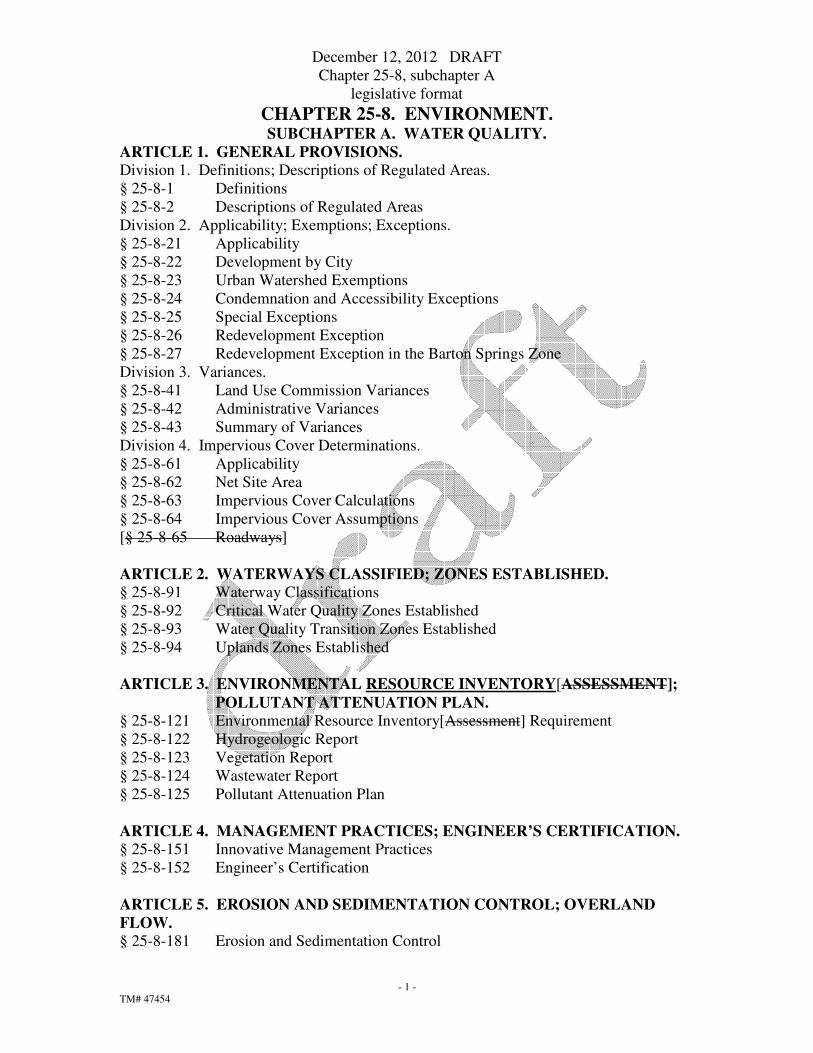
CHAPTER 25-8. ENVIRONMENT. SUBCHAPTER A. WATER QUALITY.
ARTICLE 1. GENERAL PROVISIONS.
Division 1. Definitions; Descriptions of Regulated Areas.
§ 25-8-1 Definitions
§ 25-8-2 Descriptions of Regulated Areas
Division 2. Applicability; Exemptions; Exceptions.
§ 25-8-21 Applicability
§ 25-8-22 Development by City
§ 25-8-23 Urban Watershed Exemptions
§ 25-8-24 Condemnation and Accessibility Exceptions
§ 25-8-25 Special Exceptions
§ 25-8-26 Redevelopment Exception
§ 25-8-27 Redevelopment Exception in the Barton Springs Zone
Division 3. Variances.
§ 25-8-41 Land Use Commission Variances
§ 25-8-42 Administrative Variances
§ 25-8-43 Summary of Variances
Division 4. Impervious Cover Determinations.
§ 25-8-61 Applicability
§ 25-8-62 Net Site Area
§ 25-8-63 Impervious Cover Calculations
§ 25-8-64 Impervious Cover Assumptions
[§ 25-8-65 Roadways]
ARTICLE 2. WATERWAYS CLASSIFIED; ZONES ESTABLISHED.
§ 25-8-91 Waterway Classifications
§ 25-8-92 Critical Water Quality Zones Established
§ 25-8-93 Water Quality Transition Zones Established
§ 25-8-94 Uplands Zones Established
ARTICLE 3. ENVIRONMENTAL RESOURCE INVENTORY[ASSESSMENT];
POLLUTANT ATTENUATION PLAN.
§ 25-8-121 Environmental Resource Inventory[Assessment] Requirement
§ 25-8-122 Hydrogeologic Report
§ 25-8-123 Vegetation Report
§ 25-8-124 Wastewater Report
§ 25-8-125 Pollutant Attenuation Plan
ARTICLE 4. MANAGEMENT PRACTICES; ENGINEER’S CERTIFICATION.
§ 25-8-151 Innovative Management Practices
§ 25-8-152 Engineer’s Certification
ARTICLE 5. EROSION AND SEDIMENTATION CONTROL; OVERLAND
FLOW.
§ 25-8-181 Erosion and Sedimentation Control

December 12, 2012 DRAFT
Chapter 25-8, subchapter A
legislative format
- 2 -
TM# 47454
§ 25-8-182 Development Completion
§ 25-8-183 Modification of Erosion Control and Construction Sequencing Plans
§ 25-8-184 Additional Erosion and Sedimentation Control Requirements in the Barton
Springs Zone
§ 25-8-185 Overland Flow
§ 25-8-186 Fiscal Security
ARTICLE 6. WATER QUALITY CONTROLS.
Division 1. Requirement and Standards.
§ 25-8-211 Water Quality Control Requirement
§ 25-8-212 Previous Waivers and Special Exceptions
§ 25-8-213 Water Quality Control Standards
§ 25-8-214 Optional Payment Instead of Structural Controls in Urban Watersheds
§ 25-8-215 Cost Recovery Program
Division 2. Maintenance and Inspection.
§ 25-8-231 Water Quality Control Maintenance and Inspection
§ 25-8-232 Dedicated Fund
§ 25-8-233 Barton Springs Zone Operating Permit
§ 25-8-234 Fiscal Security in the Barton Springs Zone
ARTICLE 7. REQUIREMENTS IN ALL WATERSHEDS.
Division 1. Critical Water Quality Zone Restrictions.
§ 25-8-261 Critical Water Quality Zone Development
§ 25-8-262 Critical Water Quality Zone Street Crossings
Division 2. Protection for Special Features.
§ 25-8-281 Critical Environmental Features
§ 25-8-282 Wetland Protection
Division 3. Construction on Slopes.
§ 25-8-301 Construction of a Roadway or Driveway
§ 25-8-302 Construction of a Building or Parking Area
§ 25-8-303 Subdivision Notes
§ 25-8-304 Applicability
Division 4. Clearing.
§ 25-8-321 Clearing of Vegetation
§ 25-8-322 Clearing for a Roadway
§ 25-8-323 Temporary Storage Areas; Topsoil Protection
Division 5. Cut, Fill, and Spoil.
§ 25-8-341 Cut Requirements
§ 25-8-342 Fill Requirements
§ 25-8-343 Spoil Disposal
Division 6. Other Restrictions.
§ 25-8-361 Wastewater Restrictions
§ 25-8-362 Storm Sewer Discharge
§ 25-8-363 Blasting Prohibited
§ 25-8-364 Floodplain Modification
§ 25-8-365 Interbasin Transfer

December 12, 2012 DRAFT
Chapter 25-8, subchapter A
legislative format
- 3 -
TM# 47454
ARTICLE 8. URBAN WATERSHED REQUIREMENTS
§ 25-8-371 Applicability; Compliance
§ 25-8-372 Uplands Zone
ARTICLE 9[8]. SUBURBAN WATERSHED REQUIREMENTS.
§ 25-8-391 Applicability; Compliance
[§ 25-8-392 Critical Water Quality Zone
§ 25-8-393 Water Quality Transition Zone]
§ 25-8-392[394] Uplands Zone
§ 25-8-393[395] Transfer of Development Intensity
ARTICLE 10[9]. WATER SUPPLY SUBURBAN WATERSHED
REQUIREMENTS.
§ 25-8-421 Applicability; Compliance
[§ 25-8-422 Critical Water Quality Zone]
§ 25-8-422 [423] Water Quality Transition Zone
§ 25-8-423[424] Uplands Zone
§ 25-8-424[425] Transfer of Development Intensity
ARTICLE 11[10]. WATER SUPPLY RURAL WATERSHED REQUIREMENTS.
§ 25-8-451 Applicability; Compliance
[§ 25-8-452 Critical Water Quality Zone]
§ 25-8-452[453] Water Quality Transition Zone
§ 25-8-453[454] Uplands Zone
§ 25-8-454[455] Transfer of Development Intensity
ARTICLE 12[11]. BARTON SPRINGS ZONE REQUIREMENTS.
§ 25-8-481 Applicability; Compliance
[§ 25-8-482 Critical Water Quality Zone]
§ 25-8-482[483] Water Quality Transition Zone
§ 25-8-483[484] Transfer of Development Intensity
ARTICLE 13[12]. SAVE OUR SPRINGS INITIATIVE.
§ 25-8-511 Title and Purpose
§ 25-8-512 Amendment
§ 25-8-513 Declaration of Intent
§ 25-8-514 Pollution Prevention Required
§ 25-8-515 No Exemptions, Special Exceptions, Waivers or Variances
§ 25-8-516 Application to Existing Tracts, Platted Lots, and Public Schools
§ 25-8-517 Expiration of Prior Approvals
§ 25-8-518 Limited Adjustment to Resolve Possible Conflicts with Other Laws
§ 25-8-519 Construction of Ordinance
§ 25-8-520 Reduce Risk of Accidental Contamination

December 12, 2012 DRAFT
Chapter 25-8, subchapter A
legislative format
- 4 -
TM# 47454
§ 25-8-521 Efficient and Cost-effective Water Quality Protection Measures
§ 25-8-522 Severability
§ 25-8-523 Adoption of Water Quality Measures
December 12, 2012 DRAFT
Chapter 25-8, subchapter A
legislative format
- 5 -
TM# 47454
SUBCHAPTER A. WATER QUALITY.
ARTICLE 1. GENERAL PROVISIONS.
Division 1. Definitions; Descriptions of Regulated Areas.
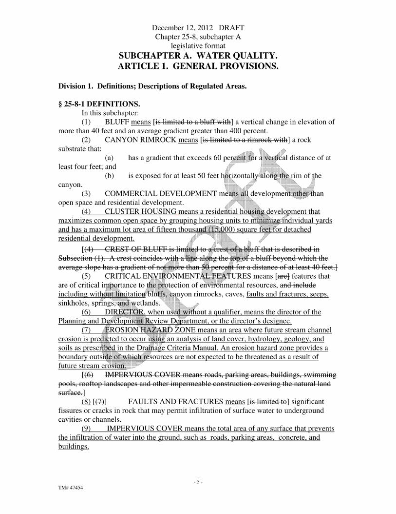
§ 25-8-1 DEFINITIONS.
In this subchapter:
(1) BLUFF means [is limited to a bluff with] a vertical change in elevation of
more than 40 feet and an average gradient greater than 400 percent.
(2) CANYON RIMROCK means [is limited to a rimrock with] a rock
substrate that:
(a) has a gradient that exceeds 60 percent for a vertical distance of at
least four feet; and
(b) is exposed for at least 50 feet horizontally along the rim of the
canyon.
(3) COMMERCIAL DEVELOPMENT means all development other than
open space and residential development. (4) CLUSTER HOUSING means a residential housing development that
maximizes common open space by grouping housing units to minimize individual yards
and has a maximum lot area of fifteen thousand (15,000) square feet for detached
residential development.
[(4) CREST OF BLUFF is limited to a crest of a bluff that is described in
Subsection (1). A crest coincides with a line along the top of a bluff beyond which the
average slope has a gradient of not more than 50 percent for a distance of at least 40 feet.]
(5) CRITICAL ENVIRONMENTAL FEATURES means [are] features that
are of critical importance to the protection of environmental resources, and include
including without limitation bluffs, canyon rimrocks, caves, faults and fractures, seeps,
sinkholes, springs, and wetlands.
(6) DIRECTOR, when used without a qualifier, means the director of the
Planning and Development Review Department, or the director’s designee.
(7) EROSION HAZARD ZONE means an area where future stream channel
erosion is predicted to occur using an analysis of land cover, hydrology, geology, and
soils as prescribed in the Drainage Criteria Manual. An erosion hazard zone provides a
boundary outside of which resources are not expected to be threatened as a result of
future stream erosion.
[(6) IMPERVIOUS COVER means roads, parking areas, buildings, swimming
pools, rooftop landscapes and other impermeable construction covering the natural land
surface.]
(8) [(7)] FAULTS AND FRACTURES means [is limited to] significant
fissures or cracks in rock that may permit infiltration of surface water to underground
cavities or channels.
(9) IMPERVIOUS COVER means the total area of any surface that prevents
the infiltration of water into the ground, such as roads, parking areas, concrete, and
buildings.

December 12, 2012 DRAFT
Chapter 25-8, subchapter A
legislative format
- 6 -
TM# 47454
(10) MULTI-USE TRAIL means a facility designated for the shared use of
pedestrians, bicycles, and other non-motorized users and associated bridges.
(11) OPEN SPACE means an area intended for outdoor activities which does
not significantly alter the existing natural vegetation, drainage patterns, or increase
erosion and includes a public or private park, multi-use trails, golf cart path, and the
portions of a golf course left in a natural state.
(12)([8)] OWNER includes a lessee.
(13)[(9)] POINT RECHARGE FEATURE means a cave, sinkhole, fault,
joint, or other natural feature that lies over the Edwards Aquifer recharge zone and that
may transmit a significant amount of surface water into the subsurface strata.
(14)[(10)] WATER QUALITY CONTROL means a structure, system, or
feature that provides water quality benefits by treating stormwater run-off.
(15)[(11)] WETLAND means a transitional land between terrestrial and
aquatic systems where the water table is usually at or near the surface or the land is
covered by shallow water, and conforms to the Army Corps of Engineers’ definition.
§ 25-8-2 DESCRIPTIONS OF REGULATED AREAS.
(A) This section describes the watersheds, aquifers, and water zones that are
regulated by this subchapter. A map of these areas is maintained by the Watershed
Protection Department and available for inspection at the offices of the Planning
[Watershed Protection] and Development Review Department.
(B) Except as provided in Subsection (C), the director of the Watershed
Protection Department shall determine the boundaries of the areas described in
Subsection (D).
(C) The council shall determine the boundaries of the Edwards Aquifer
recharge zone after receiving a recommendation from the director of the Watershed
Protection Department. For property within 1500 feet of a boundary, the director of the
Watershed Protection Department may require that an applicant provide a certified report
from a geologist or hydrologist verifying the boundary location.
(D) In this subchapter:
(1) BARTON SPRINGS ZONE means all watersheds that contribute
recharge to Barton Springs, including those portions of the Barton, Little Barton,
Williamson, Slaughter, Onion, South Boggy, Bear and Little Bear Creek watersheds
located in the Edwards Aquifer recharge or contributing zones.
(2) BARTON CREEK WATERSHED means the land area that drains
to Barton Creek, including Little Barton Creek watershed.
(3) EDWARDS AQUIFER is the water-bearing substrata also known
as the Edwards and Associated Limestones Aquifer and includes the stratigraphic rock
units known as the Edwards Formation and Georgetown Formation.
(4) EDWARDS AQUIFER CONTRIBUTING ZONE means all land
generally to the west and upstream of the Edwards Aquifer recharge zone that provides
drainage into the Edwards Aquifer recharge zone.
(5) EDWARDS AQUIFER RECHARGE ZONE means all land over
the Edwards Aquifer that recharges the aquifer, as determined by the surface exposure of
the geologic units comprising the Edwards Aquifer, including the areas overlain with
quaternary terrace deposits.

December 12, 2012 DRAFT
Chapter 25-8, subchapter A
legislative format
- 7 -
TM# 47454
(6) SOUTH EDWARDS AQUIFER RECHARGE ZONE means the
portion of the Edwards Aquifer recharge zone that is located south of the Colorado River
and north of the Blanco River.
(7) SUBURBAN WATERSHEDS include all watersheds not
otherwise classified as urban, water supply suburban, or water supply rural watersheds,
and include:
(a) the Brushy, Buttercup, Carson, Cedar, Cottonmouth,
Country Club East, Country Club West, Decker, [Dry Creek NE,] Dry Creek East, Elm
Creek, Elm Creek South, Gilleland, Harris Branch, Lake,Lockwood, Maha, Marble,
North Fork Dry, Plum [Creek], Rattan, Rinard, [South Boggy]South Fork Dry, South
Brushy, Walnut, and Wilbarger creek watersheds;
(b) the Colorado River watershed downstream of U.S. 183; and
(c) those portions of the Onion, Bear, Little Bear, Slaughter,
South Boggy, and Williamson creek watersheds not located in the Edwards Aquifer
recharge or contributing zones.
(8) URBAN WATERSHEDS include:
(a) the Blunn, Buttermilk, [East] Boggy, East Bouldin, Fort,
Harper Branch, Johnson, Little Walnut, Shoal, Tannehill, Waller, and West Bouldin
creek watersheds;
(b) the north side of the Colorado River watershed from
Johnson Creek to U.S. 183; and
(c) the south side of the Colorado River watershed from Barton
Creek to U.S. 183.
(9) WATER SUPPLY RURAL WATERSHEDS include:
(a) the Lake Travis watershed;
(b)[ and the Lake Austin watershed, excluding the Bull Creek
watershed and the area to the south of Bull Creek and the east of Lake Austin[.]; and
(c) the Bear West, Bee, Bohl’s Hollow, Cedar Hollow, Coldwater,
Commons Ford, Connors, Cuernavaca, Harrison Hollow, Hog Pen, Honey,
Little Bee, Panther Hollow, Running Deer, St. Stephens, Steiner, and
Turkey Creek watersheds.
(10) WATER SUPPLY SUBURBAN WATERSHEDS include:
(a) the Bull, Eanes, Dry Creek North, Huck’s Slough, Taylor
Slough North, Taylor Slough South, and West Bull creek watersheds;
(b) theLady Bird [Town] Lake watershed on the south side of
Lady Bird[Town] Lake from Barton Creek to Tom Miller Dam;
(c) the Lady Bird[Town] Lake watershed on the north side of
Lady Bird[Town] Lake from Johnson Creek to Tom Miller Dam; and
(d) the [Town] Lake Austin watershed on the east side of Lake
Austin from Tom Miller Dam to Bull Creek.
Division 2. Applicability; Exemptions; Exceptions.
§ 25-8-21 APPLICABILITY.

December 12, 2012 DRAFT
Chapter 25-8, subchapter A
legislative format
- 8 -
TM# 47454
(A) Except as provided in Subsection (B), this subchapter applies in the
planning jurisdiction.
(B) For a preliminary plan, final plat, or subdivision construction plan in the
portion of the city’s extraterritorial jurisdiction that is within Travis County:
(1) this subchapter does not apply; and
(2) Title 30 (Austin/Travis County Subdivision Regulations) governs.
§ 25-8-22 DEVELOPMENT BY CITY.
The requirements of this subchapter apply to land development by the City.
§ 25-8-23 URBAN WATERSHED EXEMPTIONS.
In an urban watershed, development is exempt from the requirements of this
subchapter if the development is[:
(1) ]exempt from site plan requirements under Section 25-5-2 (Site Plan
Exemptions).[;
(2) included in an application for site plan approval filed before August 30,
1991; or
(3) located in a rural residence zoning district.]
§ 25-8-24 CONDEMNATION AND ACCESSIBILITY EXCEPTIONS.
(A) This subsection applies to property that has existing development or that is
included in an approved site plan if the development on the property is reconfigured as a
result of right-of-way condemnation.
(1) The accountable official may approve the replacement of
development that existed in the condemned area of the property onto the remainder of the
property.
(2) For development that may be replaced under Subsection (A)(1),
the director may vary the requirements of this subchapter for development in the water
quality transition zone and the critical water quality zone and the limitations of this
subchapter on impervious cover after making a determination that the replacement
development will not increase the pollutant loading.
(B) For property that had existing development or that was included in a
released site plan on March 10, 1996, the accountable official may approve additional
development that exceeds the impervious cover limitations of this title if the director
determines that the increased impervious cover is necessary to comply with the
accessibility standards of the Americans With Disabilities Act or the Uniform Building
Code.
§ 25-8-25 SPECIAL EXCEPTIONS.
Except as prohibited by Article 12 (Save Our Springs Initiative), a special
exception from the requirements of this subchapter may be granted in accordance with
Chapter 25-1 (General Requirements and Procedures).
§ 25-8-26 REDEVELOPMENT EXCEPTION

December 12, 2012 DRAFT
Chapter 25-8, subchapter A
legislative format
- 9 -
TM# 47454
(A) This section applies to property that has existing authorized development if the
property owner files a site plan application and an election for the property to be
governed by this section.
(B) The requirements of this subchapter do not apply to the redevelopment of the
property if the redevelopment:
(1) does not increase the existing amount of impervious cover;
(2) provides the level of water quality treatment prescribed by current regulations
for the redeveloped area or an equivalent area on the site;
(3) does not generate more than 2,000 vehicle trips a day above the estimated
traffic level based on the most recent authorized use on the property [on April
17, 2000];
(4) is consistent with the neighborhood plan adopted by council, if any; and
[(5) for property in the drinking water protection zone, combined with all other
redevelopment of the site since April 17, 2000 does not affect more than 25
percent of the site’s impervious cover.
(C) To the extent of conflict with Article 12 (Save Our Springs Initiative), this
section controls.
§ 25-8-27 REDEVELOPMENT EXCEPTION IN THE BARTON SPRINGS ZONE.
(A) This section applies to property that has existing authorized commercial
development and is located in the Barton Springs Zone if the property owner files a site
plan application and an election for the property to be governed by this section.
(B) For property governed by this section, this section supersedes Article 12 (Save
Our Springs Initiative), to the extent of conflict.
(C) Development may comply with this section instead of complying with Section
25-8-26 (Redevelopment Exception).
(D) In this section:
(1) SEDIMENTATION/FILTRATION POND means water quality controls that
comply with Section 25-8-213 (Water Quality Control Standards) or are approved under
Section 25-8-151 (Innovative Management Practices); and
(2) SOS POND means water quality controls that comply with all requirements
of Section 25-8-213 (Water Quality Control Standards) and the pollutant removal
requirements of Section 25-8-514(A) (Pollution Prevention Required).
(E) The requirements of this subchapter do not apply to the subdivision of property
if at the time of redevelopment under this section subdivision and site plan applications
are filed concurrently.
(F) The requirements of this subchapter do not apply to the redevelopment of
property if the redevelopment meets all of the following conditions:
(1) The redevelopment may not increase the existing amount of impervious
cover on the site.
(2) The redevelopment may not increase non-compliance, if any, with Section
25-8-261 (Critical Water Quality Zone Development), Section 25-8-281 (Critical
Environmental Features), Section 25-8-282 (Wetland Protection), [Section 25-8-

December 12, 2012 DRAFT
Chapter 25-8, subchapter A
legislative format
- 10 -
TM# 47454
482(Critical Water Quality Zone),] or Section 25-8-482 [25-8-483](Water Quality
Transition Zone).
(3) The redevelopment must comply with construction phase environmental
requirements in effect at the time of construction, including Chapter 25-8, Article 5
(Erosion and Sedimentation Control; Overland Flow) and Section 25-8-234 (Fiscal
Security in the Barton Springs Zone).
(4) The water quality controls on the redevelopment site must provide a level of
water quality treatment that is equal to or greater than that which was previously
provided.
(5) For a commercial or multifamily redevelopment, the owner or operator must
obtain a permit under Section 25-8-233 (Barton Springs Zone Operating Permit) for both
sedimentation/filtration ponds and SOS ponds.
(6) For a site with more than 40 percent net site area impervious cover, the
redevelopment must have:
(a) sedimentation/filtration ponds for the entire site; or
(b) [ if approved by the director of the Watershed Protection and Development
Review] Department,]SOS ponds for a portion of the site, and sedimentation/filtration
ponds for the remainder of the site, as prescribed by the Environmental Criteria Manual.
(7) For a site with 40 percent or less net site area impervious cover, the
redevelopment must have SOS ponds for the entire site.
(8) The property owner must mitigate the effects of the redevelopment, if
required by and in accordance with Subsection (H) [(I)].
(G) City Council approval of a redevelopment in accordance with Subsection (H) is
required if the redevelopment:
(1) includes more than 25 dwelling units;
(2) is located outside the City's zoning jurisdiction;
(3) is proposed on property with an existing industrial or civic use;
(4) is inconsistent with a neighborhood plan; or
(5) will generate more than 2,000 vehicle trips a day above the estimated traffic
level based on the most recent authorized use on the property.
(H) City Council shall consider the following factors in determining whether to
approve a proposed redevelopment:
(1) benefits of the redevelopment to the community;
(2) whether the proposed mitigation or manner of development offsets the
potential environmental impact of the redevelopment;
(3) the effects of offsite infrastructure requirements of the redevelopment; and
(4) compatibility with the city's long-range planning goals.
(I) Redevelopment of property under this section requires the purchase or restriction
of mitigation land if the site has a sedimentation/filtration pond.
(1) The combined gross site area impervious cover of the mitigation land and the
portion of the redevelopment site treated by sedimentation/filtration ponds may not
exceed 20 percent.

December 12, 2012 DRAFT
Chapter 25-8, subchapter A
legislative format
- 11 -
TM# 47454
(2) The mitigation requirement may be satisfied by:
(a) paying into the Barton Springs Zone Mitigation Fund a non- refundable
amount established by ordinance;
(b) transferring to the City in accordance with Paragraph (3) mitigation land
approved by the director of the Watershed Protection [and Development Review]
Department within a watershed that contributes recharge to Barton Springs, either inside
or outside the City's jurisdiction;
(c) placing restrictions in accordance with Paragraph (3) on mitigation land
approved by the director of the Watershed Protection [and Development Review]
Department within a watershed that contributes recharge to Barton Springs, either inside
or outside the City's jurisdiction; or
(d) a combination of the mitigation methods described in Subparagraphs (a) -
(c), if approved by the director of the Watershed Protection [and Development Review]
Department.
(3) A person redeveloping under this section shall pay all costs of restricting the
mitigation land or transferring the mitigation land to the City, including the costs of:
(a) an environmental site assessment without any recommendations for
further clean-up, certified to the City not earlier than the 120th day before the closing
date transferring land to the City;
(b) a category 1(a) land title survey, certified to the City and the title
company not earlier than the 120th day before the closing date transferring land to the
City;
(c) a title commitment with copies of all Schedule B and C documents, and an
owner's title policy;
(d) a fee simple deed, or, for a restriction, a restrictive covenant approved as
to form by the city attorney;
(e) taxes prorated to the closing date;
(f) recording fees; and
(g) charges or fees collected by the title company.
(J) The Watershed Protection [and Development Review] Department shall adopt
rules to identify criteria for director of the Watershed Protection Department approval
under this section to ensure that the proposed mitigation, manner of development, and
water quality controls offset the potential environmental impact of the redevelopment.
Division 3. Variances.
§ 25-8-41 LAND USE COMMISSION VARIANCES.
(A) It is the applicant’s burden to establish that the findings described in this
Section have been met. Except as provided in Subsections (B), (C) and (D) [(C)], the
Land Use Commission may grant a variance from a requirement of this subchapter after
determining that:

December 12, 2012 DRAFT
Chapter 25-8, subchapter A
legislative format
- 12 -
TM# 47454
(1) the requirement will deprive the applicant of a privilege or the
safety of property given to owners of other similarly situated property with approximately
contemporaneous development;
(2) the variance:
(a) is not based on a condition caused by the method chosen by
the applicant to develop the property, unless the development method provides greater
overall environmental protection than is achievable without the variance;
(b) is the minimum change necessary to avoid the deprivation
of a privilege given to other property owners and to allow a reasonable use of the
property; and
(c) does not create a significant probability of harmful
environmental consequences; and
(3) development with the variance will result in water quality that is at
least equal to the water quality achievable without the variance.
(B) The Land Use Commission may grant a variance from a requirement of
Section 25-8-261 (D) (Critical Water Quality Zone Development) to allow a wastewater
line in the critical water quality zone after determining that:
(1) the criteria for granting a variance in Subsection (A) are met; and
(2) the wastewater line is located outside the two-year flood plain.
(C) [(B)]The Land Use Commission may grant a variance from a requirement of
[Section 25-8-393 (Water Quality Transition Zone),] Section 25-8-422 [25-8-423] (Water
Quality Transition Zone), Section 25-8-452 [25-8-453] (Water Quality Transition Zone),
Section 25-8-482 (Water Quality Transition Zone),or Article 7, Division 1 (Critical
Water Quality Zone Restrictions) after determining that:
(1) the criteria for granting a variance in Subsection (A) are met;
(2) the requirement for which a variance is requested prevents a
reasonable, economic use of the entire property; and
(3) the variance is the minimum change necessary to allow a
reasonable, economic use of the entire property.
(D) [(C]) The Land Use Commission may not grant a variance from a
requirement of Article 12 (Save Our Springs Initiative).
(E) [(D)] The Land Use Commission shall prepare written findings of fact to
support the grant or denial of a variance request under this section.
§ 25-8-42 ADMINISTRATIVE VARIANCES.
(A) A variance under this section may not vary the requirements of Article 12
(Save Our Springs Initiative) and may not be granted for development of a property if
any portion of the property abuts or is within 500 feet of the shoreline of Lake Austin,
measured horizontally.
(B) The director may grant a variance from a requirement of:
(1) Section 25-8-261 (Critical Water Quality Zone Development), only
if necessary to protect the environment or public health and safety;
(2) Subsection 25-8-262 (D) (Critical Water Quality Zone Street
Crossings), only outside the Barton Springs Zone;
(3) Section 25-8-281 (Critical Environmental Features);
December 12, 2012 DRAFT
Chapter 25-8, subchapter A
legislative format
- 13 -
TM# 47454
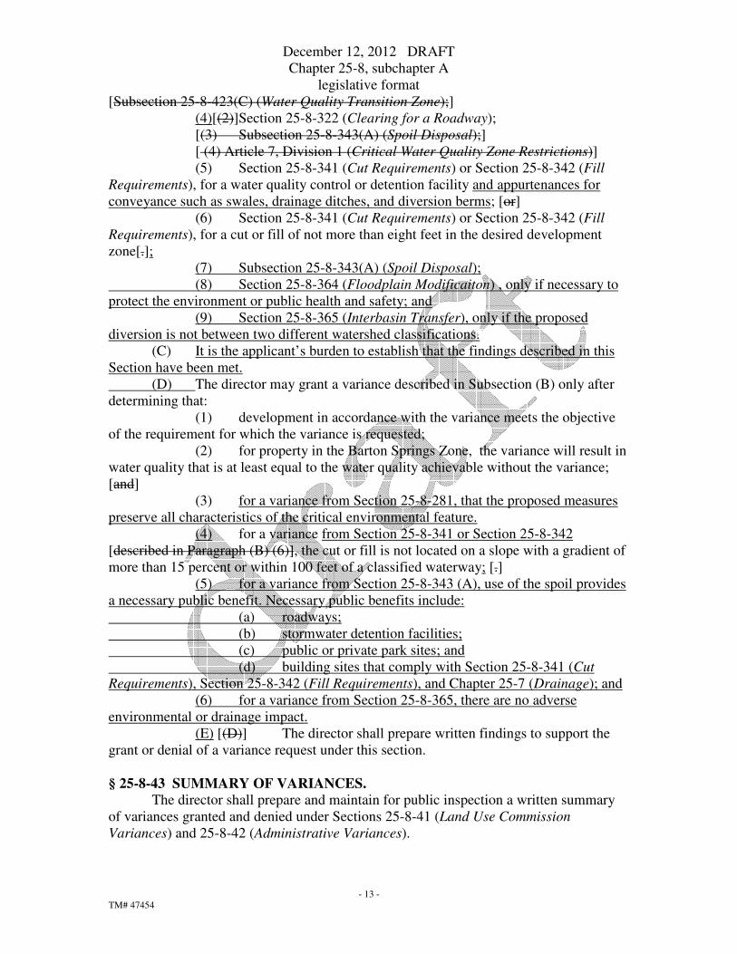
[Subsection 25-8-423(C) (Water Quality Transition Zone);]
(4)[(2)]Section 25-8-322 (Clearing for a Roadway);
[(3) Subsection 25-8-343(A) (Spoil Disposal);]
[ (4) Article 7, Division 1 (Critical Water Quality Zone Restrictions)]
(5) Section 25-8-341 (Cut Requirements) or Section 25-8-342 (Fill
Requirements), for a water quality control or detention facility and appurtenances for
conveyance such as swales, drainage ditches, and diversion berms; [or]
(6) Section 25-8-341 (Cut Requirements) or Section 25-8-342 (Fill
Requirements), for a cut or fill of not more than eight feet in the desired development
zone[.];
(7) Subsection 25-8-343(A) (Spoil Disposal);
(8) Section 25-8-364 (Floodplain Modificaiton) , only if necessary to
protect the environment or public health and safety; and
(9) Section 25-8-365 (Interbasin Transfer), only if the proposed
diversion is not between two different watershed classifications.
(C) It is the applicant’s burden to establish that the findings described in this
Section have been met.
(D) The director may grant a variance described in Subsection (B) only after
determining that:
(1) development in accordance with the variance meets the objective
of the requirement for which the variance is requested;
(2) for property in the Barton Springs Zone, the variance will result in
water quality that is at least equal to the water quality achievable without the variance;
[and]
(3) for a variance from Section 25-8-281, that the proposed measures
preserve all characteristics of the critical environmental feature.
(4) for a variance from Section 25-8-341 or Section 25-8-342
[described in Paragraph (B) (6)], the cut or fill is not located on a slope with a gradient of
more than 15 percent or within 100 feet of a classified waterway; [.]
(5) for a variance from Section 25-8-343 (A), use of the spoil provides
a necessary public benefit. Necessary public benefits include:
(a) roadways;
(b) stormwater detention facilities;
(c) public or private park sites; and
(d) building sites that comply with Section 25-8-341 (Cut
Requirements), Section 25-8-342 (Fill Requirements), and Chapter 25-7 (Drainage); and
(6) for a variance from Section 25-8-365, there are no adverse
environmental or drainage impact.
(E) [(D)] The director shall prepare written findings to support the
grant or denial of a variance request under this section.
§ 25-8-43 SUMMARY OF VARIANCES.
The director shall prepare and maintain for public inspection a written summary
of variances granted and denied under Sections 25-8-41 (Land Use Commission
Variances) and 25-8-42 (Administrative Variances).

December 12, 2012 DRAFT
Chapter 25-8, subchapter A
legislative format
- 14 -
TM# 47454
Division 4. Impervious Cover Determinations.
§ 25-8-61 APPLICABILITY.
(A) This division applies to the impervious cover requirements of this
subchapter.
(B) The impervious cover requirements of this subchapter do not restrict
impervious cover on a single-family or duplex lot but apply to the subdivision as a whole.
§ 25-8-62 NET SITE AREA.
(A) Net site area includes only the portions of a site that lie in an uplands zone
and have not been designated for wastewater irrigation.
(B) For land described in Subsection (A), net site area is the aggregate of:
(1) 100 percent of the land with a gradient of 15 percent or less;
(2) 40 percent of the land with a gradient of more than 15 percent and
not more than 25 percent; and
(3) 20 percent of the land with a gradient of more than 25 percent and
not more than 35 percent.
§ 25-8-63 IMPERVIOUS COVER CALCULATIONS.
(A) Impervious cover is calculated in accordance with this Section and the
Environmental Criteria Manual.
(B) Impervious cover calculations include:
(1) roads;
(2) driveways;
(3) parking areas;
(4) buildings;
(5) concrete;
(6) impermeable construction covering the natural land surface;
(7) for an uncovered wood deck that has drainage spaces between the
deck boards and that is located over a pervious surface, 50 percent
of the horizontal area of the deck; and
(8) [ interlocking or permeable pavers, except up to 20 percent of the
area of the pavers may be excluded in calculating impervious cover
if the pavers are ]approved by the director for recharge
enhancement under Section 25-8-151 (Innovative Management
Practices); and
(9) ]the portion of a site used for the storage of scrap and metal
salvage, including auto salvage.
(C) Impervious cover calculations exclude:
(1) sidewalks in a public right-of-way;
(2) multi-use trails open to the public and located on public land or in
a public easement;
(3) water quality controls unless covered by an impervious surface;
(4) detention basins, unless covered by an impervious surface;

December 12, 2012 DRAFT
Chapter 25-8, subchapter A
legislative format
- 15 -
TM# 47454
(5)[(3)]drainage swales and conveyances;
(6)[(4)]ponds, pools, and fountains; [and]
(7)[(5)]areas with gravel placed over pervious surfaces that are used only
for landscaping or by pedestrians and are not constructed with
compacted base;
(8) porous pavement designed in accordance with the Environmental
Criteria Manual, limited to only pedestrian walkways and multi-
use trails, and located outside the Edwards Aquifer Recharge
Zone;
(9) fire lanes designed as prescribed by the Environmental Criteria
Manual, that consist of interlocking pavers, and are restricted
from routine vehicle access; and
(10) a subsurface portion of a parking structure if the director
determines that:
(a) the subsurface portion of the structure:
(i) is located within an urban or suburban watershed;
(ii)is below the grade of the land that existed before
construction of the structure;
(iii)is covered by soil with a minimum depth of two feet
and an average depth of not less than four feet; and
(iv)has an area not greater than fifteen percent of the site;
(b) the structure is not associated with a use regulated by Section
1.2.2 of Subchapter F of Chapter 25-2 (Residential Design and
Compatibility Standards);
(c) the applicant submits an assessment of the presence and depth
of groundwater at the site sufficient to determine whether
groundwater will need to be discharged or impounded; and
(d) the applicant submits documentation that the discharge or
impoundment of groundwater from the structure, if any, will be
managed to avoid adverse effects on public health and safety, the
environment, and adjacent property.
[(D) Chapter 25-2, Subchapter E, Section 2.3.1.B. 1.e. (Impervious Cover
Credit) provides for certain exclusions from impervious cover calculations for large
development sites outside the Barton Springs Zone.]
§ 25-8-64 IMPERVIOUS COVER ASSUMPTIONS.
(A) This section applies to impervious cover calculations for duplex or single-
family lots.
(B) Except as provided in Subsection (C):
(1) for each lot greater than three acres in size, 10,000 square feet of
impervious cover is assumed;
(2) for each lot greater than one acre and not more than three acres in
size, 7,000 square feet of impervious cover is assumed;
(3) for each lot greater than 15,000 square feet and not more than one
acre in size, 5,000 square feet of impervious cover is assumed;

December 12, 2012 DRAFT
Chapter 25-8, subchapter A
legislative format
- 16 -
TM# 47454
(4) for each lot greater than 10,000 square feet and not more than
15,000 square feet in size, 3,500 square feet of impervious cover is assumed; and
(5) for each lot not more than 10,000 square feet in size, 2,500 square
feet of impervious cover is assumed.
(C) For a lot that is restricted to a lesser amount of impervious cover than
prescribed by this section, the lesser amount of impervious cover is assumed. The
manner in which the lot is restricted is subject to the approval of the director.
(D) Except as provided in Subsection (C), this section does not restrict
impervious cover on an individual lot.
[§ 25-8-65 ROADWAYS.
(A) Except as otherwise provided in this section, impervious cover
calculations for development adjacent to a roadway shall account for the adjacent
roadway.
(B) For development with an internal roadway, impervious cover calculations
include the internal roadway, except that pavement width in excess of 44 feet is excluded.
This does not reduce the requirements for stormwater detention facilities or water quality
controls for run-off from the roadways.
(C) For development adjacent to a roadway built as a City Capital
Improvements Program project after May 18, 1986, impervious cover calculations
include one-half of the pavement width, up to a maximum of 44 feet, and the associated
right-of-way.]
ARTICLE 2. WATERWAYS CLASSIFIED; ZONES ESTABLISHED.
§ 25-8-91 WATERWAY CLASSIFICATIONS.
(A) This section classifies the [significant] waterways in each watershed
according to drainage area.
(B) In all watersheds [a suburban watershed]:
(1) a minor waterway has a drainage area of at least 64[320] acres and
not more than 320[640] acres;
(2) an intermediate waterway has a drainage area of more than
320[640] acres and not more than 640[1280] acres; and
(3) a major waterway has a drainage area of more than 640[1280]
acres.
[(C) In a water supply suburban watershed:
(1) a minor waterway has a drainage area of at least 128 acres and not
more than 320 acres;
(2) an intermediate waterway has a drainage area of more than 320
acres and not more than 640 acres; and
(3) a major waterway has a drainage area of more than 640 acres.
(D) In a water supply rural watershed:
(1) a minor waterway has a drainage area of at least 64 acres and not
more than 320 acres;
(2) an intermediate waterway has a drainage area of more than 320
acres and not more than 640 acres; and
December 12, 2012 DRAFT
Chapter 25-8, subchapter A
legislative format
- 17 -
TM# 47454
(3) a waterway has a drainage area of more than 640 acres.
(E) In the Barton Springs Zone:
(1) for the Barton Creek, Bear Creek, Little Barton Creek, Little Bear
Creek, and Onion Creek watersheds:
(a) a minor waterway has a drainage area of at least 64 acres
and not more than 320 acres;
(b) an intermediate waterway has a drainage area of more than
320 acres and not more than 640 acres; and
(c) a major waterway has a drainage area of more than 640
acres; and
(2) for the Slaughter Creek and Williamson Creek watersheds:
(a) a minor waterway has a drainage area of at least 128 acres
and not more than 320 acres;
(b) an intermediate waterway has a drainage area of more than
320 acres and not more than 640 acres; and
(c) a major waterway has a drainage area of more than 640
acres.]
§ 25-8-92 CRITICAL WATER QUALITY ZONES ESTABLISHED.
(A) In the water supply rural, water supply suburban, and Barton Springs zone
watersheds, a [A] critical water quality zone is established along each waterway
classified under Section 25-8-91 (Waterway Classifications).
(1) The boundaries of a critical water quality zone coincide with the
boundaries of the 100 year flood plain calculated under fully developed conditions as
prescribed by the Drainage Criteria Manual, except:
(a) for a minor waterway, the boundaries of the critical water
quality zone are located not less than 50 feet and not more than 100 feet from the
centerline of the waterway;
(b) for an intermediate waterway, the boundaries of the critical
water quality zone are located not less than 100 feet and not more than 200 feet from the
centerline of the waterway;
(c) for a major waterway, the boundaries of the critical water
quality zone are located not less than 200 feet and not more than 400 feet from the
centerline of the waterway; and
(d) for the main channel of Barton Creek, the boundaries of the
critical water quality zone are located 400 feet from the centerline of the creek.
(2) Notwithstanding the provisions of Subsections (A) (1) (a), (b), and
(c), a critical water quality zone does not apply to a previously modified drainage feature
located within a public roadway right of way that does not possess any natural and
traditional character and cannot reasonably be restored to a natural condition [extend
beyond the crest of a bluff].
(B) In the urban and suburban watersheds, a critical water quality zone is
established along each waterway classified under Section 25-8-91 (Waterway
Classifications).
December 12, 2012 DRAFT
Chapter 25-8, subchapter A
legislative format
- 18 -
TM# 47454
(1) for a minor waterway, the boundaries of the critical water quality
zone are located 100 feet from the centerline of the waterway;
(2) for an intermediate waterway, the boundaries of the critical water
quality zone are located 200 feet from the centerline of the waterway; and
(3) for a major waterway, the boundaries of the critical water quality
zone are located 300 feet from the centerline of the waterway.
(4) The critical water quality zone boundaries may be reduced to not
less than 50 feet from the centerline of a minor waterway, 100 feet from the centerline of
an intermediate waterway, and 150 feet from the centerline of a major waterway if the
overall surface area of the critical water quality zone is the same or greater than the
surface area that would be provided without the reduction, as prescribed in the
Environmental Criteria Manual.
(5) Notwithstanding the provisions of Subsections (B) (1), (2), and (3),
a critical water quality zone does not apply to a previously modified drainage feature
located within a public roadway right of way that does not possess any natural and
traditional character and cannot be restored to a natural condition.
(C) Critical water quality zones are established to include the inundated areas
that constitute Lake Walter E. Long, Lake Austin, Lady Bird Lake, and the Colorado
River downstream of Lady Bird Lake.
(D)[(C)] Critical water quality zones are established along and parallel to
the shorelines of Lake Travis, Lake Austin, and Lady Bird[Town] Lake.
(1) The shoreline boundary of a critical water quality zone:
(a) for Lake Travis, coincides with the 681.0 foot contour line;
(b) for Lake Austin, coincides with the 492.8 foot contour line;
and
(c) for Lady Bird[Town] Lake, coincides with the 429.0 foot
contour line.
(2) The width of a critical water quality zone, measured horizontally
inland, is:
(a) 100 feet; or
(b) for a detached single-family residential use, 75 feet.
(E)[(D)] Critical water quality zones are established along and parallel to
the shorelines of the Colorado River downstream of Lady Bird[Town] Lake.
(1) The shoreline boundary of a critical water quality zone coincides
with the river's ordinary high water mark, as defined by Code of Federal Regulations
Title 33, Section 328.3 (Definitions).
(2) The inland boundary of a critical water quality zone coincides with
the boundary of the 100-year floodplain as delineated by the Federal Emergency
Management Agency, except that the width of the critical water quality zone, measured
horizontally inland, is not less than 200 feet and not more than 400 feet.
(F)[(E)] Critical water quality zones are not applicable to creeks located[In
an urban watershed, a critical water quality zone is established along each waterway with
a drainage area of at least 64acres. This does not apply] in the area bounded by IH-35,
Riverside Drive, Barton Springs Road, Lamar Boulevard, and 15th Street.

December 12, 2012 DRAFT
Chapter 25-8, subchapter A
legislative format
- 19 -
TM# 47454
[(1) Except as limited by Paragraph (3), for a waterway whose 100 year
flood plain has been delineated by the Federal Emergency Management Agency
(FEMA):
(a) the boundaries of the critical water quality zone coincide
with the boundaries of the flood plain as delineated by FEMA; or
(b) if the applicant has calculated the 100 year flood plain for
the waterway and the City has approved the calculations, the boundaries of the critical
water quality zone coincide with the boundaries of the calculated flood plain.
(2) Except as limited by Paragraph (3), for a waterway whose 100 year
flood plain has not been delineated by FEMA:
(a) the boundaries of a critical water quality zone are located
100 feet from the centerline of the waterway; or
(b) if the applicant has calculated the 100 year flood plain for
the waterway and the City has approved the calculations, the boundaries of the critical
water quality zone coincide with the boundaries of the calculated floodplain.
(3) The boundaries of a critical water quality zone are located not less
than 50 feet and not more than 400 feet from the centerline of the waterway.]
§ 25-8-93 WATER QUALITY TRANSITION ZONES ESTABLISHED.
(A) In the water supply rural or water supply suburban watershed, and in the
Barton Springs Zone, excluding[Except for] Lake Austin, Lake Travis, and Lady
Bird[Town] Lake, a water quality transition zone is established adjacent and parallel to
the outer boundary of each critical water quality zone.
(B) The width of a water quality transition zone is:
(1) for a minor waterway, 100 feet;
(2) for an intermediate waterway, 200 feet; and
(3) for a major waterway, 300 feet.
§ 25-8-94 UPLANDS ZONES ESTABLISHED.
An uplands zone includes all land and waters not included in a critical water
quality zone or a water quality transition zone.
ARTICLE 3. ENVIRONMENTAL RESOURCE INVENTORY [ASSESSMENT];
POLLUTANT ATTENUATION PLAN.
§ 25-8-121 ENVIRONMENTAL RESOURCE INVENTORY[ASSESSMENT]
REQUIREMENT.
(A) An applicant shall file an environmental resource inventory[assessment]
with the director for proposed development located:
(1) over a karst aquifer;
(2) within an area draining to a karst aquifer or reservoir;
(3) in a water quality transition zone;
(4) in a critical water quality zone;
(5) in a floodplain[flood plain]; or
(6) on a tract with a gradient of more than 15 percent.
(B) An environmental resource inventory[assessment] must:

December 12, 2012 DRAFT
Chapter 25-8, subchapter A
legislative format
- 20 -
TM# 47454
(1) identify critical environmental features and propose protection
measures for the features;
(2) provide an environmental justification for spoil disposal locations
or roadway alignments;
(3) propose methods to achieve overland flow[ and justify enclosed
storm sewers; and]
(4) describe proposed industrial uses and the pollution abatement
program; and
(5) be completed as prescribed by the Environmental Criteria Manual.
(C) An environmental resource inventory[assessment] must include:
(1) a hydrogeologic report in accordance with Section 25-8-122
(Hydrogeologic Report);
(2) a vegetation report in accordance with Section 25-8-123
(Vegetation Report); and
(3) a wastewater report in accordance with Section 25-8-124
(Wastewater Report).
(D) The director may permit an applicant to exclude from an environmental
resource inventory[assessment] information required by this section after determining
that the information is unnecessary because of the scope and nature of the proposed
development.
§ 25-8-122 HYDROGEOLOGIC REPORT.
A hydrogeologic report must:
(1) generally describe the topography, soils, and geology of the site;
(2) identify springs and significant point recharge features on the site; and
(3) demonstrate that proposed drainage patterns will protect the quality and
quantity of recharge at significant point recharge features.
§ 25-8-123 VEGETATION REPORT.
A vegetation report must:
(1) demonstrate that the proposed development:
(a) preserves to the greatest extent practicable the significant trees and
vegetation on the site; and
(b) provides maximum erosion control and overland flow benefits
from the vegetation;
(2) include one of the following:
(a) a tree survey of all trees with a diameter of at least eight inches
measured four and one-half feet above natural grade level; or
(b) on approval of the city arborist, stereo aerial photographs that are
nine inches by nine inches in size, are at a scale of one inch to 400 feet or larger, and
were photographed between the months of April and November; and
(3) for a commercial or multifamily site, include a vegetation survey that
shows the approximate locations and types of all significant vegetation.
§ 25-8-124 WASTEWATER REPORT.
A wastewater report must:

December 12, 2012 DRAFT
Chapter 25-8, subchapter A
legislative format
- 21 -
TM# 47454
(1) provide environmental justification for a sewer line location in a critical
water quality zone;
(2) address construction techniques and standards for wastewater lines;
(3) include calculations of drainfield or wastewater irrigation areas;
(4) describe [alternative] wastewater disposal systems used over the Edwards
Aquifer recharge zone; and
(5) address on-site collection and treatment systems, their treatment levels,
and effects on receiving watercourses or the Edwards Aquifer.
§ 25-8-125 POLLUTANT ATTENUATION PLAN.
An applicant proposing an industrial use that is not completely enclosed in a
building shall provide a pollutant attenuation plan in accordance with the Administrative
and the Environmental Criteria Manuals.
ARTICLE 4. MANAGEMENT PRACTICES; ENGINEER’S CERTIFICATION.
§ 25-8-151 INNOVATIVE MANAGEMENT PRACTICES.
(A) An innovative water quality control is a practice that is not specifically
prescribed in the Environmental Criteria Manual, but is designed to address the
requirements of Article 6 (Water Quality Controls).
(B) An innovative runoff management practice is a practice that is designed to
address the requirements of[ Article 6 (Water Quality Controls) and] Section 25-8-281
(Critical Environmental Features), enhance the recharge of groundwater and the
discharge of springs, and maintain the function of critical environmental features. [ The
City encourages innovative management practices.]
(C) [(B)] A proposal for an innovative water quality control or runoff
management practice must be reviewed and approved by the Watershed Protection [and
Development Review] Department. Review and approval is based on:
(1) technical merit;
(2) compliance with the requirements of this title for water quality
protection and improvement;
(3) resource protection and improvement;
(4) advantages over standard practices; and
(5) anticipated maintenance requirements.
§ 25-8-152 ENGINEER’S CERTIFICATION.
A civil engineer registered in Texas must certify a plan or plat as complete,
accurate, and in compliance with the requirements of this subchapter. The director may
waive this requirement after making a determination that the plan or plat includes only
minor alterations or improvement that do not require the services of an engineer.
ARTICLE 5. EROSION AND SEDIMENTATION CONTROL; OVERLAND
FLOW.
§ 25-8-181 EROSION AND SEDIMENTATION CONTROL.
December 12, 2012 DRAFT
Chapter 25-8, subchapter A
legislative format
- 22 -
TM# 47454
Temporary erosion and sedimentation controls:
(1) are required for all development until permanent revegetation has been
established; and
(2) must be removed after permanent revegetation has been established.
§ 25-8-182 DEVELOPMENT COMPLETION.
(A) Development is not completed until:
(1) permanent revegetation is established; and
(2) the Planning [Watershed Protection]and Development Review
Department:
(a) receives the engineer’s concurrence letter; and
(b) certifies installation of the vegetation for acceptance.
(B) Development must be completed under Subsection (A) before the City
may accept maintenance responsibility for streets, drainage facilities, or utilities, or issue
a certificate of occupancy or compliance, unless the City and the applicant enter into an
agreement to ensure completion of the revegetation within a named period.
§ 25-8-183 MODIFICATION OF EROSION CONTROL AND CONSTRUCTION
SEQUENCING PLANS.
A City inspector may modify an erosion control plan or construction sequencing
plan in the field:
(1) without notice to the permit holder, if the modification is a minor change
to upgrade erosion controls or reflect construction progress; and
(2) after two days written notice to the permit holder, if:
(a) the inspector determines that an erosion control or the construction
sequencing is inappropriate or inadequate; and
(b) the director [Watershed Protection and Development Review
Department] has confirmed in writing the inspector’s determination.
§ 25-8-184 ADDITIONAL EROSION AND SEDIMENTATION CONTROL
REQUIREMENTS IN THE BARTON SPRINGS ZONE.
(A) This section provides additional erosion and sedimentation control
requirements for development in the Barton Springs Zone.
(B) A temporary erosion and sedimentation control plan and a water quality
plan certified by a registered professional engineer and approved by the Planning
[Watershed Protection] and Development Review Department is required.
(1) The plans must describe the temporary structural controls, site
management practices, or other approved methods that will be used to control of off-site
sedimentation until permanent revegetation is certified as completed under Section 25-8-
182 (Development Completion).
(2) The temporary erosion control plan must be phased to be effective
at all stages of construction. Each temporary erosion control method must be adjusted,
maintained, and repaired as necessary.
(C) The Planning [Watershed Protection] and Development Review
Department may require a modification of the temporary erosion control plan after
determining that the plan does not adequately control off-site sedimentation from the

December 12, 2012 DRAFT
Chapter 25-8, subchapter A
legislative format
- 23 -
TM# 47454
development. Approval by the Planning [Watershed Protection] and Development
Review Department and the engineer who certified the plan is required for a major
modification of the plan.
(D) The owner shall designate a project manager who is responsible for
compliance with the erosion and sedimentation control and water quality plan
requirements during development.
(E) The length of time between clearing and final revegetation of development
may not exceed 18 months, unless extended by the director.
(F) If an applicant does not comply with the deadline in Subsection (E), or
does not adequately maintain the temporary erosion and sedimentation controls, the
director shall notify the applicant in writing that the City will repair the controls or
revegetate the disturbed area at the applicant’s expense unless the work is completed or
revegetation is begun not later than the 15th day after the date of the notice.
(G) A person commits an offense if the person allows sediment from a
construction site to enter a waterway by failing to maintain erosion controls or failing to
follow the approved sequence of construction.
§ 25-8-185 OVERLAND FLOW.
(A) Drainage patterns must be designed to:
(1) prevent erosion;
(2) maintain infiltration and recharge of local seeps and springs;
(3) attenuate the harm of contaminants collected and transported by
stormwater; and
(4) where possible, maintain and restore overland sheet flow, maintain
natural drainage features and patterns, and disperse runoff back to sheet flow.
[(B) Construction of an enclosed storm sewer or an impervious channel lining
is prohibited unless the director determines, based on engineering evidence, that an
enclosed storm sewers or impervious channel lining is the preferred option. A conflict
between the requirements of this subsection and another requirement of this title may be
resolved by an appeal to the Land Use Commission.]
(B) [(C)] The applicant shall design an enclosed storm sewer to mitigate
potential adverse impacts [its harmful effect] on water quality by using structural devices
or other methods to prevent erosion and dissipate discharges from outlets wherever
practicable, and by locating discharges to maximize overland flow through buffer zones
or grass-lined swales.
§ 25-8-186 FISCAL SECURITY
A site plan may be approved only if the applicant provides fiscal security for:
(1) installing and maintaining erosion and sedimentation controls throughout
construction on the site;
(2) revegetating the site; and
(3) performing on-site and off-site cleanup.
ARTICLE 6. WATER QUALITY CONTROLS.
Division 1. Requirement and Standards.

December 12, 2012 DRAFT
Chapter 25-8, subchapter A
legislative format
- 24 -
TM# 47454
§ 25-8-211 WATER QUALITY CONTROL REQUIREMENT.
(A) In the Barton Springs Zone, water quality controls are required for all
development.
(B) In a watershed other than a Barton Springs Zone watershed, water quality
controls are required for development:
(1) located in the water quality transition zone;
(2) of a golf course, play field, or similar recreational use, if fertilizer,
herbicide, or pesticide is applied; or
(3) if the cumulative total of new and redeveloped impervious cover
exceeds 8,000 square feet.[ except as provided in Subsection (C), with impervious cover
that exceeds 20 percent of net site area.]
(C) [In an urban watershed:
(1) water quality controls are required in accordance with the
Environmental Criteria Manual; and
(2) new] All new development must provide for removal of floating
debris from stormwater runoff.
(D) The water quality control requirements in this division do not require
water quality controls on a single-family or duplex lot but apply to the residential
subdivision as a whole.
§ 25-8-212 PREVIOUS WAIVERS AND SPECIAL EXCEPTIONS.
Water quality controls in accordance with Section 25-8-213 (Water Quality
Control Standards) are required for a commercial or multifamily development with more
than 20 percent impervious cover that has been granted a waiver of previous water
quality requirements or a special exception under this subchapter.
§ 25-8-213 WATER QUALITY CONTROL STANDARDS.
(A) A water quality control must be designed in accordance with the
Environmental Criteria Manual.
(1) The control must provide at least the treatment level of a
sedimentation / filtration system under the Environmental Criteria Manual.
(2) An impervious liner is required in an area where there is surface
runoff to groundwater conductivity. If a liner is required and controls are located in
series, liners are not required for the second or later in the series following sedimentation,
extended detention, or sedimentation/filtration.
(3) The control must be accessible for maintenance and inspection as
prescribed in the Environmental Criteria Manual.
(B) A water quality control must capture [, isolate,] and treat the water
draining to the control from the contributing area. The required capture volume is:
(1) the first one-half inch of runoff; and
(2) for each 10 percent increase in impervious cover over 20 percent
of gross site area, an additional one-tenth of an inch of runoff.
(C) The location of a water quality control:
(1) must avoid recharge features to the greatest extent possible;

December 12, 2012 DRAFT
Chapter 25-8, subchapter A
legislative format
- 25 -
TM# 47454
(2) must be shown on the slope map, preliminary plan, site plan, or
subdivision construction plan, as applicable; and
(3) in a water supply rural watershed, may not be in the 40 percent
buffer zone, unless the control disturbs less than 50% of the buffer, and is located to
maximize overland flow and recharge in the undisturbed remainder of the 40 percent
buffer zone.
(D) This subsection provides additional requirements for the Barton Springs
Zone.
(1) Approval by the Watershed Protection [and Development Review]
Department is required for a proposed water quality control that is not described in the
Environmental Criteria Manual. The applicant must substantiate the pollutant removal
efficiency of the proposed control with published literature or a verifiable engineering
study.
(2) Water quality controls must be placed in sequence if necessary to
remove the required amount of pollutant. The sequence of controls must be:
(a) based on the Environmental Criteria Manual or generally
accepted engineering principles; and
(b) designed to minimize maintenance requirements.
§ 25-8-214 OPTIONAL PAYMENT INSTEAD OF STRUCTURAL CONTROLS
IN URBAN WATERSHEDS.
(A) The director shall identify and prioritize water quality control facilities for
the urban watersheds in the Urban Watersheds Structural Control Plan. The
Environmental Board shall review the plan in January of each year.
(B) An Urban Watersheds Structural Control Fund is established for use in the
design and construction of water quality control facilities in the urban watersheds.
(C) Instead of providing the water quality controls required under Section 25-
8-211 (Water Quality Control Requirement), in an urban watershed a developer may
request approval to deposit with the City a nonrefundable cash payment, based on a
formula established by the council. The director shall review the request and accept or
deny the request based on the standards in the Environmental Criteria Manual[not later
than the 15th working day after its receipt].
(D) The director shall deposit a payment made under this section in the Urban
Watersheds Structural Control Fund.
§ 25-8-215 COST RECOVERY PROGRAM.
A person who redevelops property in an urban watershed and is required to
construct a water quality control may qualify for cost participation by the City for:
(1) construction of the water quality control; or
(2) optional payment instead of construction of the water quality control under
Section 25-8-214 (Optional Payment Instead Of Structural Controls In Urban
Watersheds).
Division 2. Maintenance and Inspection.
§ 25-8-231 WATER QUALITY CONTROL MAINTENANCE AND INSPECTION.

December 12, 2012 DRAFT
Chapter 25-8, subchapter A
legislative format
- 26 -
TM# 47454
(A) In this section:
(1) COMMERCIAL DEVELOPMENT means all development other
than Residential Development.
(2) COMMERCIAL POND means a required water quality control or
appurtenance that receives stormwater runoff from a Commercial Development.
(3) ECM STANDARDS means the provisions in the Environmental
Criteria Manual regarding maintenance of a required water quality control or
appurtenance.
(4) RESIDENTIAL DEVELOPMENT means development of two
dwelling units or less per lot.
(5) RESIDENTIAL POND means a required water quality control or
appurtenance that receives stormwater runoff from a Residential Development.
(B) The record owner of a commercial development shall maintain the
commercial pond serving the commercial development in accordance with the ECM
standards, whether or not the commercial pond is located on the same property as the
commercial development. The record owner shall provide the City proof of the right to
access and maintain the commercial pond if it is not located on the same property as the
commercial development.
(C) If more than one commercial development is served by a single
commercial pond, the record owners of the commercial pond and all commercial
developments served by the commercial pond shall be jointly and severally responsible
for maintenance of the commercial pond in accordance with the ECM standards.
(D) The director may authorize an alternative arrangement for maintenance of
a residential or commercial basin in accordance with the DCM standards. If an
alternative arrangement is approved by the director, the city attorney shall determine
whether an agreement is necessary; the agreement must be approved by the city attorney
and filed of record.
(E) The City shall inspect each commercial pond that is not a subsurface pond
at least once every three years to ensure that the commercial pond is being maintained in
accordance with the ECM standards. If the commercial pond fails inspection requiring an
additional inspection, the director may charge a re-inspection fee.
(F) The record owner of a subsurface commercial pond must provide the
Watershed Protection Department with a maintenance plan and an annual report from a
registered engineer verifying that the pond is in proper operating condition.
(G)Until the City accepts a residential pond for maintenance, the record owner(s)
of the residential pond and the residential development served shall maintain the
residential pond in accordance with the ECM standards.
(H)[(G)] The City shall be responsible for maintenance of a residential pond
only after the residential pond has been accepted for maintenance by the city. The city
will accept a residential pond upon determining that it meets the requirements of the
Environmental Criteria Manual and, if applicable, Section 25-8-234 (Fiscal Security in
the Barton Springs Zone).
§ 25-8-232 DEDICATED FUND.
(A) The director of Finance shall establish a dedicated fund to:
(1) monitor water quality controls; and

December 12, 2012 DRAFT
Chapter 25-8, subchapter A
legislative format
- 27 -
TM# 47454
(2) maintain water quality controls for single-family and duplex
residential development.
(B) An applicant shall pay the required fee into the fund:
(1) for development that does not require a site plan, when the
applicant posts fiscal security for the subdivision or requests that the director record the
subdivision plat, whichever occurs first; or
(2) for development that requires a site plan, when the site plan is
approved.
(C) The director of the Watershed Protection [and Development Review]
Department shall report annually to the council regarding the status of the fund and the
monitoring and maintenance program described in this section.
§ 25-8-233 BARTON SPRINGS ZONE OPERATING PERMIT.
(A) In the Barton Springs Zone, the owner or operator of a commercial or
multifamily development is required to obtain an annual operating permit for the required
water quality controls.
(B) To obtain an annual operating permit, an applicant must:
(1) provide the Planning [Watershed Protection] and Development
Review Department with:
(a) a maintenance plan; and
(b) the information necessary to verify that the water quality
controls are in proper operating condition; and
(2) pay the required, nonrefundable fee.
(C) The Planning [Watershed Protection] and Development Review
Department may verify that a water quality control is in proper operating condition by
either inspecting the water quality control or accepting a report from a registered
engineer.
(D) The Planning [Watershed Protection] and Development Review
Department shall issue an operating permit after determining that:
(1) the applicant has complied with the requirements of Subsection
(B); and
(2) the water quality controls are in proper operating condition.
(E) The Planning [Watershed Protection] and Development Review
Department shall transfer an operating permit to a new owner or operator if, not later than
30 days after a change in ownership or operation, the new owner or operator:
(1) signs the operating permit;
(2) accepts responsibility for the water quality controls; and
(3) documents the transfer on a form provided by the Planning
[Watershed Protection] and Development Review Department.
§ 25-8-234 FISCAL SECURITY IN THE BARTON SPRINGS ZONE.
(A) For development in the Barton Springs Zone, an applicant shall provide
the City with fiscal security to ensure that water quality controls are maintained properly.
The director shall calculate the amount of fiscal security in accordance with the formula
in the Environmental Criteria Manual.
(B) The director may not return the fiscal security to the applicant until:

December 12, 2012 DRAFT
Chapter 25-8, subchapter A
legislative format
- 28 -
TM# 47454
(1) the expiration of one year after the completion of the development;
and
(2) the director receives verification that the controls are constructed
in accordance with the approved design by:
(a) the applicant’s delivery of a certified engineering
concurrence letter; and
(b) a report from a City inspector.
ARTICLE 7. REQUIREMENTS IN ALL WATERSHEDS.
Division 1. Critical Water Quality Zone Restrictions.
§ 25-8-261 CRITICAL WATER QUALITY ZONE DEVELOPMENT.
In all watersheds, development is prohibited in a critical water quality zone except
as provided in this Division.
(A) A fence that does not obstruct flood flows is permitted in a critical water
quality zone.
(B) Open space[A public or private park, golf course, or open spaces, other
than a parking lot,]is permitted in a critical water quality zone if a program of fertilizer,
pesticide, and herbicide use is approved by the Watershed Protection [and Development
Review] Department.
(1) In a water supply rural watershed or the Barton Springs Zone, open
space [park development] is limited to multi-use trails, picnic facilities[ hiking, jogging,
or walking trails ]and outdoor facilities, excluding [and excludes] stables and corrals for
animals.
(2) In a water supply rural watershed or the Barton Springs Zone, a
master planned park that is reviewed by the Land Use Commission and approved by the
council may include recreational development other than that described in Subsection
(B)(1).
(3) Open space may include sustainable urban agriculture or a
community garden if:
(a) located a minimum of 50 feet from the centerline of a minor
waterway, 100 feet from the centerline of an intermediate waterway, and 150 feet from
the centerline of a major waterway;
(b) designed in accordance with the Environmental Criteria
Manual; and
(c) limited to garden plots and paths, with no storage facilities or
other structures.
(C) Along Lake Travis, Lake Austin, or Lady Bird[Town] Lake:
(1) a boat dock, pier, wharf, or marina and necessary access and
appurtenances, is permitted in a critical water quality zone; and
(2) approval by the Watershed Protection [and Development Review]
Department of chemicals used to treat building materials that will be submerged in water
is required before a permit may be issued or a site plan released.
[In the Barton Springs Zone:

December 12, 2012 DRAFT
Chapter 25-8, subchapter A
legislative format
- 29 -
TM# 47454
(1) a boat ramp dock, pier, wharf, or marina and necessary access and
appurtenances, or a pedestrian bridge, or bicycle or golf cart path, is permitted in a
critical water quality zone; and
(2) approval by the Watershed Protection and Development Review
Department of chemicals used to treat building materials that will be submerged in water
is required before a permit may be issued or a site plan released.]
(D)[(E)] A utility line is prohibited in the critical water quality zone, except
as provided in subsection (E) or for a necessary crossing. A necessary utility crossing
may cross into or through a critical water quality zone[.] if:
(1) the utility line follows the most direct path into or across the critical
water quality zone to minimize disturbance;
(2) the depth of the utility line and location of associated access shafts are
not located within an erosion hazard zone; and
(3) in [In] the Barton Springs Zone, approval by the director is required for
a utility line crossing.
(E) In the urban and suburban watersheds, a utility line may be located
parallel to and within the critical water quality zone if:
(1) located a minimum of 50 feet from the centerline of a minor waterway,
100 feet from the centerline of an intermediate waterway, and 150 feet from the
centerline of a major waterway;
(2) designed in accordance with the Environmental Criteria Manual; and
(3) located outside the erosion hazard zone.
(F) [Except in the Barton Springs Zone,] Detention [detention] basins and wet
ponds, [and floodplain alterations] are prohibited [permitted] in the critical water quality
zone unless[if]:
(1) the requirements of Section 25-8-364 (Floodplain Modification),
Chapter 25-7 (Drainage), and the other provisions of this subchapter are met; and
(2) the basin or pond is designed in accordance with the Drainage and
Environmental Criteria Manuals.
(G) Floodplain modifications are prohibited in the critical water quality zone
unless:
(1) the floodplain modifications proposed are necessary to protect the
environment or the protect the public health and safety; or
(2) the floodplain modifications proposed are necessary for development
allowed in the critical zone under section 25-8-261 (Critical Water Quality Zone
Development) or 25-8-262 (Critical Water Quality Zone Street Crossings)
(H) In the urban and suburban watersheds, vegetative filter strips, rain
gardens, biofiltration ponds, areas used for irrigation or infiltration of stormwater, or
other controls as prescribed by rule are allowed in the critical water quality zone if:
(1) located no less than 50 feet from the centerline of a minor waterway,
no less than 100 feet from the centerline of an intermediate waterway, and no less than
150 feet from the centerline of a major waterway;
(2) located outside the 100 year floodplain; and
(3) located outside the erosion hazard zone.
(I) A residential lot that is 5,750 square feet or less in size may not include
any portion of a critical water quality zone.

December 12, 2012 DRAFT
Chapter 25-8, subchapter A
legislative format
- 30 -
TM# 47454
§ 25-8-262 CRITICAL WATER QUALITY ZONE STREET CROSSINGS.
(A) In an urban watershed, an arterial, collector, or residential street may cross
a critical water quality zone of any waterway.
(B) In all watersheds, multi-use trails may cross a critical water quality zone
of any waterway.
(C) Except in the Barton Springs Zone, the director may approve a street or
driveway crossing the critical water quality zone if located in a center or corridor as
identified on the growth concept map of the Imagine Austin Comprehensive Plan, as
adopted by Ordinance No. 20120614-058, if the proposed crossing:
(1) is necessary to facilitate the development or redevelopment of a
designated corridor or center as recommended in the Imagine Austin Comprehensive
Plan, Chapter 4 (Shaping Austin: Building the Complete Community), growth concept
map and related definitions; and
(2) maintains the quality and quantity of recharge if located in a center or
corridor designated as a sensitive environmental area in the Edwards Aquifer recharge
zone, Edwards Aquifer contributing zone, or the South Edwards Aquifer recharge zone.
(D) This subsection applies in watershed other than an urban watershed.
(1) A major waterway critical water quality zone may be crossed by an
arterial street identified in the Transportation Plan.
(2) An intermediate waterway critical water quality zone may be
crossed by an arterial or collector street, except:
(a) a collector street crossing must be at least 2,500 feet from a
collector or arterial street crossing on the same waterway; or
(b) in a water supply suburban or water supply rural watershed,
or the Barton Springs Zone, a collector street crossing must be at least one mile from a
collector or arterial street crossing on the same waterway.
(3) A minor waterway critical water quality zone may be crossed by
an arterial and collector streets, except:
(a) a collector street crossing must be at least 900[1,000] feet
from a collector or arterial street crossing on the same waterway; or
(b) in a water supply suburban or water supply rural watershed,
or the Barton Springs Zone, a collector street crossing must be at least 2,000 feet from a
collector or arterial street crossing on the same waterway.
(4) A minor waterway critical water quality zone may be crossed by a
residential or commercial street if necessary to provide access to property that cannot
otherwise be safely accessed.
[(C) Except in the Barton Springs Zone, the director may vary the requirements
of Subsection (B).]
Division 2. Protection for Special Features.
§ 25-8-281 CRITICAL ENVIRONMENTAL FEATURES.
(A) Drainage patterns for proposed development must be designed to protect
critical environmental features from the effects of runoff from developed areas, and to
maintain the catchment areas of recharge features in a natural state. Special controls must

December 12, 2012 DRAFT
Chapter 25-8, subchapter A
legislative format
- 31 -
TM# 47454
be used where necessary to avoid the effects of erosion, or sedimentation, or high rates of
flow.
(B) A residential lot may not include a critical environmental feature or be
located within 50 feet of a critical environmental feature.
(C) This subsection prescribes the requirements for critical environmental
feature buffer zones.
(1) A buffer zone is established around each critical environmental
feature described in this subchapter.
(a) Except as provided in Subsection (C)(1)(b), the width of
the buffer zone is 150 feet from the edge of the critical environmental feature.
(b) For a point recharge feature, the buffer zone coincides with
the topographically defined catchment basin, except that the width of the buffer zone
from the edge of the critical environmental feature is:
(i) not less than 150 feet; [and]
(ii) not more than 300 feet[.] ;and
(iii) calculated in accordance with the Environmental
Criteria Manual.
(2) Within a buffer zone described in this subsection:
(a) the natural vegetative cover must be retained to the
maximum extent practicable;
(b) construction is prohibited; and
(c) wastewater disposal or irrigation is prohibited.
(3) If located at least 50 feet from the edge of the critical
environmental feature, the prohibition of Subsection (C)(2)(b) does not apply to:
(a) a yard or hiking trail; [or]
(b) a recharge basin approved under Section 25-8-213 (Water
Quality Control Standards) that discharges to a point recharge feature; or
(c) an innovative runoff management practice approved under
Section 25-8-151 (Innovative Management Practices).
(4) Perimeter fencing with not less than one access gate must be
installed at the outer edge of the buffer zone for all point recharge features. The fencing
must comply with the Standard Specifications Manual.
(5) The owner must maintain the buffer zone in accordance with
standards in the Environmental Criteria Manual to preserve the water quality function of
the buffer.
(D) When voids in the rock substrate are uncovered during development, the
following protocol must be followed:
(1) construction in the area of the void must cease while the applicant
conducts a preliminary investigation of the void as prescribed by the Environmental
Criteria Manual.
(2) The applicant shall contact a City of Austin Environmental Inspector
to schedule further investigation by the City of the void as prescribed by the
Environmental Criteria Manual if the preliminary investigation indicates that the
void:

December 12, 2012 DRAFT
Chapter 25-8, subchapter A
legislative format
- 32 -
TM# 47454
(a) is one square foot in total area;
(b) blows air from within the substrate;
(c) consistently receives water during any rain event; or
(d) potentially transmits groundwater.
(3) Construction may only proceed after mitigation measures are
reviewed and approved by the Watershed Protection Department.
[The director may grant an administrative variance to a requirement unless any
portion of the property that is the subject of the administrative variance abuts or is within
500 feet of the shoreline of Lake Austin, measured horizontally. An applicant for a
variance must demonstrate that the proposed measures preserve all characteristics of the
critical environmental feature.]
§ 25-8-282 WETLAND PROTECTION.
(A) Wetlands must be protected in all watersheds except in the area bounded
by Interstate 35, Riverside Drive, Barton Springs Road, Lamar Boulevard, and 15th
Street[central business area].
(B) Protection methods for wetlands include:
(1) appropriate setbacks that preserve the wetlands or wetland
functions;
(2) wetland mitigation, including wetland replacement;
(3) wetland restoration or enhancement; or
(4) use of a wetlands for water quality controls.
(C) The director may approve:
(1) the removal and replacement of a wetland; or
(2) the elimination of setbacks from a wetland that is proposed to be
used as a water quality control.
Division 3. Construction on Slopes.
§ 25-8-301 CONSTRUCTION OF A ROADWAY OR DRIVEWAY.
(A) A person may not construct a roadway or driveway on a slope with a
gradient of more than 15 percent unless the construction is necessary to provide primary
access to:
(1) at least two contiguous acres with a gradient of 15 percent or less;
or
(2) building sites for at least five residential units.
(B) For construction described in this section, a cut or fill must be revegetated,
or if a cut or fill has a finished gradient of more than 33 percent, stabilized with a
permanent structure. This does not apply to a stable cut.
§ 25-8-302 CONSTRUCTION OF A BUILDING OR PARKING AREA.
(A) A person may not construct:
(1) a building or parking structure on a slope with a gradient of more
than 25 percent; or
(2) except for a parking structure, a parking area on a slope with a
gradient of more than 15 percent.

December 12, 2012 DRAFT
Chapter 25-8, subchapter A
legislative format
- 33 -
TM# 47454
(B) A person may construct a building or parking structure on a slope with a
gradient of more than 15 percent and not more than 25 percent if the requirements of this
subsection are met.
(1) Impervious cover on slopes with a gradients of more than 15
percent may not exceed 10 percent of the total area of the slopes.
(2) The terracing techniques in the Environmental Criteria Manual are
required for construction that is uphill or downhill of a slope with a gradient of more than
15 percent.
(3) Hillside vegetation may not be disturbed except as necessary for
construction, and disturbed areas must be restored with native and adapted vegetation as
prescribed in the Environmental Criteria Manual.
(4) For construction described in this section, a cut or fill must be
revegetated, or if a cut or fill has a finished gradient of more than 33 percent, stabilized
with a permanent structure. This does not apply to a stable cut.
§ 25-8-303 SUBDIVISION NOTES.
(A) A preliminary subdivision plan that proposes a single family residential lot
on a slope with a gradient of more than 15 percent must include a plan note identifying
the lot and describing the requirements of Subsection (B).
(B) A final plat that proposes a single family residential lot on a slope with a
gradient of more than 15 percent must include a plat note:
(1) identifying the lot; and
(2) stating the impervious cover and construction requirements for the
lot.
§ 25-8-304 APPLICABILITY.
This division does not apply in an urban watershed.
Division 4. Clearing.
§ 25-8-321 CLEARING OF VEGETATION.
(A) Clearing of vegetation is prohibited unless the director determines that the
clearing:
(1) is in accordance with a released site plan or subdivision
construction plan;
(2) is permitted under this section or Section 25-8-322 (Clearing For
A Roadway); or
(3) is not development, as that term is defined in Chapter 25-1
(General Requirements and Procedures).
(B) Clearing of vegetation on land used for agricultural purposes is prohibited
if an application to develop for a non-agricultural use has been granted or is pending.
The director may waive this prohibition after determining that the clearing has a bonafide
agricultural purpose and is unrelated to the proposed development or sale of the land for
non-agricultural uses.

December 12, 2012 DRAFT
Chapter 25-8, subchapter A
legislative format
- 34 -
TM# 47454
(C) A person may clear an area up to 15 feet wide or remove a tree with a
diameter of not more than eight inches to perform surveying or geologic testing in
preparation for site plan or final plat approval.
§ 25-8-322 CLEARING FOR A ROADWAY.
(A) A person may clear an area for road construction after site plan or final
plat approval under this section.
(B) Roadway clearing width may not exceed:
(1) twice the roadway surface width, or the width of the dedicated
right-of-way, whichever is less; or
(2) for road construction problem areas of less than 300 feet in length,
two and one-half times the roadway width.
(C) The director may grant an administrative variance to Subsection (B) if
required by unusual topographic conditions.
(D) If clearing on slopes could result in materials sliding onto areas beyond the
clearing widths described in Subsection (B), retaining walls or other preventative
methods are required.
(E) The length of time between rough cutting and final surfacing of roadways
may not exceed 18 months.
(F) If the applicant does not meet the deadline described in Subsection (E), the
city manager shall notify the applicant in writing that the City will finish the roadways or
revegetate the disturbed area at the applicant’s expense unless the work is completed not
later than the 60th day after the date of the notice.
§ 25-8-323 TEMPORARY STORAGE AREAS; TOPSOIL PROTECTION.
(A) The site plan or subdivision construction plan must designate the areas to
be cleared for temporary storage of spoils or construction equipment. Areas cleared for
temporary storage must be located and restored in accordance with the Environmental
Criteria Manual.
(B) During and after site grading operations, the topsoil must be protected and
vegetation left in place to the maximum extent practicable.
Division 5. Cut, Fill, and Spoil.
§ 25-8-341 CUT REQUIREMENTS.
(A) Cuts on a tract of land may not exceed four feet of depth, except:
(1) in an urban watershed;
(2) in a roadway right-of-way;
(3) for construction of a building foundation;
(4) for utility construction or a wastewater drain field, if the area is
restored to natural grade;
(5) in a state-permitted sanitary landfill or a sand or gravel excavation
located in the extraterritorial jurisdiction, if:
(a) the cut is not in a critical water quality zone;
(b) the cut does not alter a 100-year floodplain;

December 12, 2012 DRAFT
Chapter 25-8, subchapter A
legislative format
- 35 -
TM# 47454
(c) the landfill or excavation has an erosion and restoration
plan approved by the City; and
(d) all other applicable City Code provisions are met.
(B) A cut must be restored and stabilized.
(C) A roadway cut must be contained within the roadway clearing width
described in Section 25-8-322 (Clearing For A Roadway).
§ 25-8-342 FILL REQUIREMENTS.
(A) Fill on a tract of land may not exceed four feet of depth, except:
(1) in an urban watershed;
(2) in a roadway right-of-way;
(3) under a foundation with sides perpendicular to the ground, or with
pier and beam construction;
(4) for utility construction or a wastewater drain field; or
(5) in a state-permitted sanitary landfill located in the extraterritorial
jurisdiction, if:
(a) the fill is derived from the landfill operation;
(b) the fill is not placed in a critical water quality zone or a
100-year floodplain;
(c) the landfill operation has an erosion and restoration plan
approved by the City; and
(d) all other applicable City Code provisions are met.
(B) A fill area must be restored and stabilized.
(C) Fill for a roadway must be contained within the roadway clearing width
described in Section 25-8-322 (Clearing For A Roadway).
§ 25-8-343 SPOIL DISPOSAL.
(A) A spoil disposal site may not be located in a 100-year floodplain or on a
slope with a gradient of more than 15 percent.
[(B) The director may grant a variance to the limitation of Subsection (A) after
determining that use of the spoil provides a necessary public benefit. Necessary public
benefits include:
(1) roadways;
(2) stormwater detention facilities;
(3) public or private park sites; and
(4) building sites that comply with Section 25-8-341 (Cut
Requirements), Section 25-8-342 (Fill Requirements), and Chapter 25-7 (Drainage).]
(B) [(C)] The location of a spoil disposal site must be reasonably accessible.
An access route:
(1) must use existing and approved roadways, if possible; and
(2) may not be located in a waterway, unless:
(a) a reasonable alternative is not available; or
(b) the access route is for the construction of a water quality
control.

December 12, 2012 DRAFT
Chapter 25-8, subchapter A
legislative format
- 36 -
TM# 47454
(D) A spoil disposal site and an access route shall be restored and revegetated
in accordance with the Environmental Criteria Manual.
Division 6. Other Restrictions.
§ 25-8-361 WASTEWATER RESTRICTIONS.
(A) [A wastewater line is prohibited in a critical water quality zone, except for
a necessary crossing.
(1) The Land Use Commission may grant a variance to the prohibition
of this subsection. An applicant for a variance must provide an environmental assessment
evaluating the effects of alternative sewer alignments.
(2) Except for a necessary crossing, a wastewater line in a critical
water quality zone must be located outside the two-year flood plain unless approved by
council.
(B) ]For a lot in the Edwards Aquifer recharge zone with private on-site
sewage facilities, compliance with City Code Chapter 15-5 (Private Sewage Facilities)
must be demonstrated.[that is not served by a sanitary sewer, an alternative sewage
disposal system that does not use a conventional soil absorption drainfield is required.]
[(C) For a commercial development in a water supply rural watershed, a
wastewater disposal area may not be located in the 40 percent buffer zone. ]
[(D) This subsection applies to a residential lot using an on-site wastewater
disposal system.
(1) The lot must be at least one acre in size and must have:
(a) at least one-half acre of contiguous land with a gradient of
not more than 15 percent; or
(b) at least three-fourths acre of contiguous land with a
gradient of not more than 25 percent.
(2) The wastewater disposal system may not be located in a critical
water quality zone.
(E) A development using wastewater treatment by land application must have:
(1) at least 8,000 square feet of irrigated land for each living unit
equivalent (LUE), as that term is defined by the Water and Wastewater Department; or
(2) if the irrigated land has six inches or more of topsoil, at least 7,000
square feet of irrigated land for each LUE.]
(B)[(F)] Wastewater treatment by land application is prohibited:
(1) on a slope with a gradient of more than 15 percent;
(2) in a critical water quality zone;
(3) in a 100-year floodplain; [or]
(4) in the half critical root zone of a protected tree, as defined in
Section 25-8-602 (Definitions);
(5) in the buffer zone established around a critical environmental
feature under Section 25-8-281 (Critical Environmental Features); or
(6) [(4)] during wet weather conditions.
[(G) A package wastewater treatment plant must provide at least:
(1) 100 days of storage capacity; or
(2) if using subsurface effluent disposal, 48 hours of storage capacity.]

December 12, 2012 DRAFT
Chapter 25-8, subchapter A
legislative format
- 37 -
TM# 47454
§ 25-8-362 STORM SEWER DISCHARGE.
A certificate of occupancy may not be issued for development subject to this
subchapter unless the development is in compliance with Chapter 6-5, Article 5
(Discharges Into Storm Sewers Or Watercourses).
§ 25-8-363 BLASTING PROHIBITED.
(A) Blasting on property located in the Edwards Aquifer recharge zone is
prohibited in a critical water quality zone or a water quality transition zone, unless the
applicant demonstrates that a feasible alternative does not exist.
(B) Blasting is prohibited within 300 feet of a critical environmental feature,
unless the applicant demonstrates that a feasible alternative does not exist.
§ 25-8-364 FLOODPLAIN MODIFICATION
(A) Floodplain modification within a critical water quality zone is prohibited
except as allowed under section 25-8-261 (Critical Water Quality Zone Development).
(B) Floodplain modification outside a critical water quality zone is prohibited
except as allowed in this section.
(C) Floodplain modification is allowed if the modification proposed:
(1) is necessary to protect the environment or to protect the public health
and safety; or
(2) is located outside a floodplain with natural and traditional character,
determined by a functional assessment of existing hydrology, vegetation, and soils as
prescribed by the Environmental Criteria Manual; and
(2) encourages sound engineering practices and efficient floodplain
management, prevents and reduces degradation of water quality, and encourages the
stability and integrity of floodplains and waterways, as prescribed in the floodplain
modification criteria in the Environmental Criteria Manual.
(D) Floodplain modifications must:
(1) be designed to accommodate existing and fully-vegetated
conditions;
(2) restore hydrology, vegetation, and soils to support natural
functions and processes as prescribed in the floodplain modification criteria in the
Environmental Criteria Manual ; and
(3) comply with the requirements of Chapter 25-7 (Drainage), the
Drainage Criteria Manual, and the Environmental Criteria Manual.
§ 25-8-365 INTERBASIN TRANSFER (A) Development may not divert stormwater from one watershed to another,
except as authorized by this section.
(B) A proposed diversion of less than 20% of the site based on gross site area
or less than 1 acre, whichever is smaller, may be allowed if the applicant demonstrates
that:
(1) existing drainage patterns are maintained to the extent feasible; and
(2) there are no adverse environmental or drainage impacts.

December 12, 2012 DRAFT
Chapter 25-8, subchapter A
legislative format
- 38 -
TM# 47454
ARTICLE 8. URBAN WATERSHED REQUIREMENTS.
§ 25-8-371 APPLICABILITY; COMPLIANCE.
(A) This article applies to development in an urban watershed.
(B) A person who develops in an urban watershed must comply with the
requirements of this article.
§ 25-8-372 UPLANDS ZONE.
(A) This section applies to development in an uplands zone. Impervious cover
limits in this section are expressed as percentages of gross site area.
(B) Maximum impervious cover for development within the City’s zoning
jurisdiction is established in Section 25-2-492 (Site Development Regulations).
(C) Maximum impervious cover for development outside the City’s zoning
jurisdiction is 80 percent.
ARTICLE 9[8]. SUBURBAN WATERSHED REQUIREMENTS.
§ 25-8-391 APPLICABILITY; COMPLIANCE.
(A) This article applies to development in a suburban watershed.
(B) A person who develops in a suburban watershed must comply with the
requirements of this article.
[§ 25-8-392 CRITICAL WATER QUALITY ZONE.
Development is prohibited in a critical water quality zone, except as provided in
Article 7, Division 1 (Critical Water Quality Zone Restrictions).
§ 25-8-393 WATER QUALITY TRANSITION ZONE.
(A) In a water quality transition zone, the impervious cover of the land area of
a site may not exceed 30 percent. In determining land area, land in the 100 year
floodplain is excluded.
(B) Water quality controls may be located in a water quality transition zone.]
§ 25-8-392[394] UPLANDS ZONE.
(A) This section applies to development in an uplands zone. Impervious cover
limits in this section are expressed as percentages of gross [net] site area.
(B) This subsection applies in the extraterritorial jurisdiction and in the
portions of the Lake, Rattan, Buttercup, South Brushy, and Brushy Creek watersheds that
are in the zoning jurisdiction.
(1) Impervious cover for a single-family residential use with a
minimum lot size of 5,750 square feet may not exceed:
(a) 45 percent; or
(b) if development intensity is transferred under Section 25-8-
393[395] (Transfer Of Development Intensity), 50 percent.
(2) Impervious cover for a duplex or single-family residential use with
a lot smaller than 5,750 square feet in size may not exceed:

December 12, 2012 DRAFT
Chapter 25-8, subchapter A
legislative format
- 39 -
TM# 47454
(a) 55 percent; or
(b) if development intensity is transferred under Section 25-8-
393[395] (Transfer Of Development Intensity), 60 percent.
(3) Impervious cover for a multifamily residential use may not exceed:
(a) 60 percent; or
(b) if development intensity is transferred under Section 25-8-
393[395] (Transfer Of Development Intensity), 65 percent.
(4) Impervious cover for a commercial use may not exceed:
(a) 65 percent; or
(b) if development intensity is transferred under Section 25-8-
393[395] (Transfer Of Development Intensity), 70 percent.
(C) This subsection applies in the portion of the zoning jurisdiction that is
outside the Lake, Rattan, and Brushy Creek watersheds.
(1) Impervious cover for a single-family residential use with a
minimum lot size of 5,750 square feet may not exceed:
(a) 50 percent; or
(b) if development intensity is transferred under Section 25-8-
393[395] (Transfer Of Development Intensity), 60 percent.
(2) Impervious cover for a duplex or single-family residential use with
a lot smaller than 5,750 square feet in size may not exceed:
(a) 55 percent; or
(b) if development intensity is transferred under Section 25-8-
393[395] (Transfer Of Development Intensity), 60 percent.
(3) Impervious cover for a multifamily residential use may not exceed:
(a) 60 percent; or
(b) if development intensity is transferred under Section 25-8-
393[395] (Transfer Of Development Intensity), 70 percent.
(4) Impervious cover for a commercial use may not exceed:
(a) 80 percent; or
(b) if development intensity is transferred under Section 25-8-
393[395] (Transfer Of Development Intensity), 90 percent.
§ 25-8-393[395] TRANSFER OF DEVELOPMENT INTENSITY.
(A) An applicant who complies with a provision of this subsection qualifies
for the development intensity transfer described in the provision, subject to the
impervious cover limitations in section 25-8-392 (Uplands Zone).
(1) For each acre of land in a critical water quality zone that an
applicant dedicates in fee simple to the City or another entity; that the City or other entity
accepts; and which the applicant does not include in impervious cover calculations
elsewhere, the applicant may transfer 20,000 square feet of impervious cover to an
uplands zone. Land dedicated to the City under this subsection may also be [to] credited
toward the parkland dedication requirements of Chapter 25-4, Article 3, Division 5
(Parkland Dedication).
[(2) For each acre of land in the water quality transition zone that an
applicant leaves undeveloped and undisturbed and does not include in impervious cover

December 12, 2012 DRAFT
Chapter 25-8, subchapter A
legislative format
- 40 -
TM# 47454
calculations elsewhere, the applicant may transfer 20,000 square feet of impervious cover
to the uplands zone.
(3) For each acre of land in a water quality transition zone that an
applicant uses for a golf course or other recreational use, restores using predominantly
native plants and grasses, and provides a plan for minimizing the use and effect of
pesticides, herbicides and fertilizers, the applicant may transfer 17,000 square feet of
impervious cover to an uplands zone.
(4) For each acre of land in a water quality transition zone that an
applicant uses for wastewater disposal, the applicant may transfer 10,000 square feet of
impervious cover to an uplands zone.]
[(5) For each acre of land in an uplands zone that is located in the
buffer zone of a critical environmental feature and that an applicant leaves natural and
undisturbed, the applicant may transfer 20,000 square feet of impervious cover to an
uplands zone. The buffer area may be included in the net site area calculations for the
uplands zone.]
[(6) For each acre of land in an uplands zone that an applicant uses for
wastewater irrigation, restricts against future development, and leaves in a natural state,
other than for necessary irrigation lines and tailwater control berms, the applicant may
transfer 20,000 square feet of impervious cover to an uplands zone.]
(2) The applicant may transfer 20,000 square feet of impervious cover
to an uplands zone for each acre of land in an uplands zone:
(i) that is located in the 100-year floodplain, or
(ii) that is located in an environmentally sensitive area as
determined by environmental resource inventory and approved by the director of the
Watershed Protection Department; and
(iii) that the applicant leaves in a natural state; dedicates in fee
simple to the City or another entity; that the City of other entity accepts; and which the
applicant does not include in impervious cover calculations elsewhere.
(B) An applicant who qualifies for a development intensity transfer under
Subsection (A) must comply with requirements of this subsection to effect the transfer.
(1) For transfers between two subdivided tracts:
(a) An applicant may transfer development intensity to a receiving
tract that is within the same watershed classification as the transferring tract[not more
than one mile from the transferring tract]. This limitation does not apply if the
transferring and receiving tracts are both owned by the applicant and are separated only
by property that is also owned by the applicant.
(b)[(2)]An applicant must concurrently plat the transferring and
receiving tracts and must transfer all development intensity at that time.
(c)[(3)] An applicant must note the development intensity transfer
on the plats of the transferring and receiving tracts, in a manner determined by the
director.
(d)[(4)]An applicant must file in the deed records a restrictive
covenant, approved by the city attorney, that runs with the transferring tract and describes
the development intensity transfer.
(2) For transfers between two site plans

December 12, 2012 DRAFT
Chapter 25-8, subchapter A
legislative format
- 41 -
TM# 47454
(a) An applicant may transfer development intensity to a
receiving tract that is within the same watershed classification as the transferring tract.
This limitation does not apply if the transferring and receiving tracts are both owned by
the applicant and are separated only by property that is also owned by the applicant.
(b) The transfer must be noted on the receiving and transferring
site plans;
(c) An applicant must file in the deed records a restrictive
covenant, approved by the city attorney, that runs with the transferring tract and describes
the development intensity transfer.
(d) The transfer must occur before the receiving and
transferring site plans are released.
(3) For transfers within a single site plan, an applicant must file in the
deed records a restrictive covenant, approved by the city attorney, that runs with the
transferring tract and describes the development intensity transfer.
ARTICLE 10[9]. WATER SUPPLY SUBURBAN WATERSHED
REQUIREMENTS.
§ 25-8-421 APPLICABILITY; COMPLIANCE.
(A) This article applies to development in a water supply suburban watershed.
(B) A person who develops in a water supply suburban watershed must
comply with the requirements of this article.
[§ 25-8-422 CRITICAL WATER QUALITY ZONE.
Development is prohibited in a critical water quality zone, except as provided in
Article 7, Division 1 (Critical Water Quality Zone Restrictions).]
§ 25-8-422[423] WATER QUALITY TRANSITION ZONE.
(A) Development is prohibited in a water quality transition zone that lies over
the South Edwards Aquifer recharge zone, except for:
(1) development described in Article 7, Division 1 (Critical Water Quality
Zone Restrictions); and
(2) minor drainage facilities or water quality controls necessary to treat the
allowed development that comply with Section 25-8-364 (Floodplain Modification) and
the floodplain modification criteria in the Environmental Criteria Manual.
(B) In a water quality transition zone that does not lie over the South Edwards
Aquifer recharge zone, the impervious cover of the land area of a site may not exceed 18
percent. In determining land area, land in the 100 year floodplain is excluded.
(C) Water quality controls for development in an uplands zone or water
quality transition zone may not be located in a water quality transition zone that does not
lie over the South Edwards Aquifer recharge zone.
§ 25-8-423[424] UPLANDS ZONE.
(A) This section applies to development in an uplands zone. Impervious cover
limits in this section are expressed as percentages of net site area.

December 12, 2012 DRAFT
Chapter 25-8, subchapter A
legislative format
- 42 -
TM# 47454
(B) Impervious cover for a duplex or single-family residential use may not
exceed:
(1) 30 percent; or
(2) if development intensity is transferred under Section 25-8-
424[425] (Transfer Of Development Intensity), 40 percent.
(C) Impervious cover for a commercial or multifamily residential use may not
exceed:
(1) 40 percent; or
(2) if development intensity is transferred under Section 25-8-
424[425] (Transfer Of Development Intensity), 55 percent.
§ 25-8-424[425] TRANSFER OF DEVELOPMENT INTENSITY.
(A) An applicant who complies with a provision of this section qualifies for
the development intensity transfer described in the provision, subject to the impervious
cover liittions in section 25-8-423 (Uplands Zone).
(1) For each acre of land in a critical water quality zone that an
applicant dedicates in fee simple to the City or another entity; that the City or other entity
accepts; and which the applicant does not include in impervious cover calculations
elsewhere, the applicant may transfer 15,000 square feet of impervious cover to an
uplands zone. Land dedicated to the City under this subsection may also be [to] credited
toward the parkland dedication requirements of Chapter 25-4, Article 3, Division 5
(Parkland Dedication).
(2) For each acre of land in the water quality transition zone that an
applicant dedicates in fee simple to the City or another entity; that the City or other entity
accepts; and which the applicant [leaves undeveloped and undisturbed and]does not
include in impervious cover calculations elsewhere, the applicant may transfer 15,000
square feet of impervious cover to the uplands zone.
[(3) For each acre of land in a water quality transition zone that an
applicant uses for a golf course or other recreational use, restores using predominantly
native plants and grasses, and provides a plan for minimizing the use and effect of
pesticides, herbicides and fertilizers, the applicant may transfer 12,750 square feet of
impervious cover to an uplands zone.
(4) For each acre of land in a water quality transition zone that an
applicant uses for wastewater disposal, the applicant may transfer 7,500 square feet of
impervious cover to an uplands zone.
(5) For each acre of land in an uplands zone that is located in the
buffer zone of a critical environmental feature and that an applicant leaves natural and
undisturbed, the applicant may transfer 15,000 square feet of impervious cover to an
uplands zone. The buffer area may be included in the net site area calculations for the
uplands zone.]
[(6) For each acre of land in an uplands zone that an applicant uses for
wastewater irrigation, restricts against future development, and leaves in a natural state,
other than for necessary irrigation lines and tailwater control berms, the applicant may
transfer 15,000 square feet of impervious cover to an uplands zone.]
(B) An applicant who qualifies for a development intensity transfer under
Subsection (A) must comply with requirements of this subsection to effect the transfer.

December 12, 2012 DRAFT
Chapter 25-8, subchapter A
legislative format
- 43 -
TM# 47454
(1) For transfers between two subdivided tracts:
(a) An applicant may transfer development intensity to a receiving
tract that is within the same watershed classification as the transferring tract[not more
than one mile from the transferring tract]. This limitation does not apply if the
transferring and receiving tracts are both owned by the applicant and are separated only
by property that is also owned by the applicant.
(b)[(2)]An applicant must concurrently plat the transferring and
receiving tracts and must transfer all development intensity at that time.
(c)[(3)] An applicant must note the development intensity transfer
on the plats of the transferring and receiving tracts, in a manner determined by the
director.
(d)[(4)]An applicant must file in the deed records a restrictive
covenant, approved by the city attorney, that runs with the transferring tract and describes
the development intensity transfer.
(2) For transfers between two site plans
(a) An applicant may transfer development intensity to a
receiving tract that is within the same watershed classification as the transferring tract.
This limitation does not apply if the transferring and receiving tracts are both owned by
the applicant and are separated only by property that is also owned by the applicant.
(b) The transfer must be noted on the receiving and transferring
site plans;
(c) An applicant must file in the deed records a restrictive
covenant, approved by the city attorney, that runs with the transferring tract and describes
the development intensity transfer.
(d) The transfer must occur before the receiving and
transferring site plans are released.
(3) For transfers within a single site plan, an applicant must file in the
deed records a restrictive covenant, approved by the city attorney, that runs with the
transferring tract and describes the development intensity transfer.
ARTICLE 11[10]. WATER SUPPLY RURAL WATERSHED REQUIREMENTS.
§ 25-8-451 APPLICABILITY; COMPLIANCE.
(A) This article applies to development in a water supply rural watershed.
(B) A person who develops in a water supply rural watershed must comply
with the requirements of this article.
[§ 25-8-452 CRITICAL WATER QUALITY ZONE.
Development is prohibited in a critical water quality zone, except as provided in
Article 7, Division 1 (Critical Water Quality Zone Restrictions).]
§ 25-8-452[453] WATER QUALITY TRANSITION ZONE.
(A) Development is prohibited in a water quality transition zone that lies over
the South Edwards Aquifer recharge zone, except for:
(1) development described in Article 7, Division 1 (Critical Water Quality
Zone Restrictions); and

December 12, 2012 DRAFT
Chapter 25-8, subchapter A
legislative format
- 44 -
TM# 47454
(2) minor drainage facilities or water quality controls necessary to treat the
allowed development that comply with Section 25-8-364 (Floodplain Modification) and
the floodplain modification criteria in the Environmental Criteria Manual.
(B) Development is prohibited in a water quality transition zone that lies
outside the South Edwards Aquifer recharge zone, except for:
(1) development described in Article 7, Division 1 (Critical Water
Quality Zone Restrictions);
(2) streets;
(3) minor drainage facilities or water quality controls that comply with
Section 25-8-364 (Floodplain Modification) and the floodplain modification guidelines
of the Environmental Criteria Manual;
(4) [parks or open spaces;] and
(5) ]duplex or single-family residential development with a minimum
lot size of two acres and a density of not more than one unit for each three acres,
excluding acreage in the 100 year flood plain.
(C) A lot that lies within a critical water quality zone must also include at least
two acres in a water quality transition zone or upland zone.
[(D) Water quality controls may not be located in a water quality transition
zone.]
§ 25-8-453[454] UPLANDS ZONE.
(A) This section applies to development in an uplands zone. Density and
impervious cover limits are based on net site area.
(B) For a duplex or single family residential use, density may not exceed:
(1) one unit for each two acres, with a minimum lot size of three-
quarters acre; or
(2) if development intensity is transferred under Section 25-8-
454[455] (Transfer Of Development Intensity), one unit for each acre, with a minimum
lot size of one-half acre.
(C) This subsection applies to cluster housing.[For a cluster housing use,]
(1) density may not exceed:
(a)[(1)] one unit for each acre; or
(b)[(2)]if development intensity is transferred under Section 25-8-
454[455] (Transfer Of Development Intensity), two units for each acre.
(2) At least 40 percent of the uplands area of a site must be retained in
or restored to its natural state to serve as a buffer. The buffer must be contiguous to the
development, and must receive overland drainage from the developed areas of the site.
Use of the buffer is limited to fences, utilities that cannot reasonably be located
elsewhere, irrigation lines not associated with wastewater disposal, and access for site
construction. A wastewater disposal area may not be located in the buffer.
(D) This subsection applies to a commercial or multifamily use.
(1) Impervious cover may not exceed:
(a) 20 percent; or
(b) if development intensity is transferred under Section 25-8-
454[455] (Transfer Of Development Intensity), 25 percent.

December 12, 2012 DRAFT
Chapter 25-8, subchapter A
legislative format
- 45 -
TM# 47454
(2) At least 40 percent of the uplands area of a site must be retained in
or restored to its natural state to serve as a buffer. The [, the] buffer must be contiguous to
the development, and [ the buffer] must receive overland drainage from the developed
areas of the site. Use of the buffer is limited to fences, utilities that cannot reasonably be
located elsewhere, irrigation lines not associated with wastewater disposal, and access for
site construction. A wastewater disposal area may not be located in the buffer.
§ 25-8-454[455] TRANSFER OF DEVELOPMENT INTENSITY.
(A) An applicant who complies with a provision of this section qualifies for
the development intensity transfer described in the provision, subject to the impervious
cover limitations in section 25-8-453 (Uplands Zone).
(1) For each acre of land in a critical water quality zone that an
applicant dedicates in fee simple to the City or another entity; that the City or other entity
accepts; and which the applicant does not include in impervious cover calculations
elsewhere, the applicant may transfer one single-family residential housing unit or 6,000
square feet of impervious cover for commercial or multifamily development to an
uplands zone. Land dedicated to the City under this subsection may also be credited
toward the parkland dedication requirements of Chapter 25-4, Article 3, Division 5
(Parkland Dedication).
(2) For each acre of land in the water quality transition zone that an
applicant dedicates in fee simple to the City or another entity; that the City or other entity
accepts; and which the applicant [leaves undeveloped and undisturbed and]does not
include in impervious cover calculations elsewhere, the applicant may transfer one
single-family residential housing unit or 6,000 square feet of impervious cover for
commercial or multifamily development to the uplands zone.
[(3) For each acre of land in a water quality transition zone that an
applicant uses for a golf course or other recreational use, restores using predominantly
native plants and grasses, and provides a plan for minimizing the use and effect of
pesticides, herbicides and fertilizers, the applicant may transfer 85 percent of a single-
family residential housing unit or 5,100 square feet of impervious cover for commercial
or multifamily development to an uplands zone.
(4) For each acre of land in a water quality transition zone that an
applicant uses for wastewater disposal, the applicant may transfer 50 percent of a single-
family residential housing unit or 3,000 square feet of impervious cover for commercial
or multifamily development to an uplands zone.
(5) For each acre of land in an uplands zone that is located in the
buffer zone of a critical environmental feature and that an applicant leaves natural and
undisturbed, the applicant may transfer one single-family residential housing unit or
6,000 square feet of impervious cover for commercial or multifamily development to an
uplands zone. The buffer area may be included in the net site area calculations for the
uplands zone.
(6) For each acre of land in an uplands zone that an applicant uses for
wastewater irrigation, restricts against future development, and leaves in a natural state,
other than for necessary irrigation lines and tailwater control berms, the applicant may
transfer one single-family residential housing unit or 6,000 square feet of impervious
cover for commercial or multifamily development to an uplands zone.]

December 12, 2012 DRAFT
Chapter 25-8, subchapter A
legislative format
- 46 -
TM# 47454
(B) An applicant who qualifies for a development intensity transfer under
Subsection (A) must comply with requirements of this subsection to effect the transfer.
(1) For transfers between two subdivided tracts:
(a) An applicant may transfer development intensity to a receiving
tract that is within the same watershed classification as the transferring tract[not more
than one mile from the transferring tract]. This limitation does not apply if the
transferring and receiving tracts are both owned by the applicant and are separated only
by property that is also owned by the applicant.
(b)[(2)]An applicant must concurrently plat the transferring and
receiving tracts and must transfer all development intensity at that time.
(c)[(3)] An applicant must note the development intensity transfer
on the plats of the transferring and receiving tracts, in a manner determined by the
director.
(d)[(4)]An applicant must file in the deed records a restrictive
covenant, approved by the city attorney, that runs with the transferring tract and describes
the development intensity transfer.
(2) For transfers between two site plans
(a) An applicant may transfer development intensity to a
receiving tract that is within the same watershed classification as the transferring tract.
This limitation does not apply if the transferring and receiving tracts are both owned by
the applicant and are separated only by property that is also owned by the applicant.
(b) The transfer must be noted on the receiving and transferring
site plans;
(c) An applicant must file in the deed records a restrictive
covenant, approved by the city attorney, that runs with the transferring tract and describes
the development intensity transfer.
(d) The transfer must occur before the receiving and
transferring site plans are released.
(3) For transfers within a single site plan, an applicant must file in the
deed records a restrictive covenant, approved by the city attorney, that runs with the
transferring tract and describes the development intensity transfer.
ARTICLE 12[11]. BARTON SPRINGS ZONE REQUIREMENTS.
§ 25-8-481 APPLICABILITY; COMPLIANCE.
(A) This article applies to development in the Barton Springs Zone.
(B) A person who develops in the Barton Springs Zone must comply with the
requirements of:
(1) this article; and
(2) Article 13[12] (Save Our Springs Initiative).
[§ 25-8-482 CRITICAL WATER QUALITY ZONE.
Development is prohibited in a critical water quality zone, except as provided in
Article 7, Division 1 (Critical Water Quality Zone Restrictions).]
§ 25-8-482[483] WATER QUALITY TRANSITION ZONE.

December 12, 2012 DRAFT
Chapter 25-8, subchapter A
legislative format
- 47 -
TM# 47454
(A) Development is prohibited in a water quality transition zone that lies over
the Edwards Aquifer recharge zone, except for:
(1) development described in Article 7, Division 1 (Critical Water
Quality Zone Restrictions); and
(2) minor drainage facilities or water quality controls necessary to
treat the allowed development that comply with Section 25-8-364 (Floodplain
Modification) and the floodplain modification criteria [guidelines ]of the Environmental
Criteria Manual.
(B) Development is prohibited in a water quality transition zone that lies
outside the Edwards Aquifer recharge zone, except for:
(1) development described in Article 7, Division 1 (Critical Water
Quality Zone Restrictions);
(2) minor drainage facilities or water quality controls that comply with
Section 25-8-364 (Floodplain Modification) and the floodplain modification guidelines
of the Environmental Criteria Manual;
(3) streets; and
(4) duplex or single-family residential housing with a minimum lot
size of two acres and a density of not more than one unit for each three acres, excluding
acreage in the 100 year floodplain.[; and
(5) vegetative filter strips.]
§ 25-8-483[484] TRANSFER OF DEVELOPMENT INTENSITY.
Development intensity may not be transferred in the Barton Springs Zone except as part
of an adjustment under Section 25-8-518 (Limited Adjustment To Resolve Possible
Conflicts With Other Laws).
ARTICLE 13[12]. SAVE OUR SPRINGS INITIATIVE.
§ 25-8-511 TITLE AND PURPOSE.
(A) This article, to be known as the Save Our Springs Initiative, (SOS
hereafter) sets out special requirements for development of land in watersheds within the
City's planning jurisdiction which contribute to Barton Springs.
(B) This article codifies the Save Our Springs Initiative Petition Ordinance as
adopted by popular vote on August 8, 1992 and amended by the council.
§ 25-8-512 AMENDMENT.
This article [shall not be repealed or amended by city council until two years after
the effective date of the SOS ordinance, August 10, 1992. Thereafter, this article] may be
repealed or amended only by an affirmative vote of a three-quarters majority of the city
council.
§ 25-8-513 DECLARATION OF INTENT.
The people of the City declare their intent to preserve a clean and safe drinking
water supply, to prevent further degradation of the water quality in Barton Creek, Barton
Springs, and the Barton Springs Edwards Aquifer, to provide for fair, consistent, and cost
effective administration of the City's watershed protection ordinances, and to promote the

December 12, 2012 DRAFT
Chapter 25-8, subchapter A
legislative format
- 48 -
TM# 47454
public health, safety, and welfare. The City recognizes that the Barton Springs Edwards
Aquifer is more vulnerable to pollution from urban development than any other major
groundwater supply in Texas, and that the measures set out in this article are necessary to
protect this irreplaceable natural resource.
§ 25-8-514 POLLUTION PREVENTION REQUIRED.
(A) In the watersheds contributing to Barton Springs, no development nor any
revision, extension, or amendment thereof, may be approved unless it is designed, carried
out, and maintained on a site-by-site basis to meet the pollution prevention requirements
set forth below for the life of the project. In order to prevent pollution, impervious cover
for all such development shall be limited to a maximum of 15 percent in the entire
recharge zone, 20 percent of the contributing zone within the Barton Creek watershed,
and 25 percent in the remainder of the contributing zone. The impervious cover limits
shall be calculated on a net site area basis. In addition, runoff from such development
shall be managed through water quality controls and onsite pollution prevention and
assimilation techniques so that no increases occur in the respective average annual
loadings of total suspended solids, total phosphorus, total nitrogen, chemical oxygen
demand, biochemical oxygen demand, total lead, cadmium, E. coli, [fecal coliform, fecal
streptococci,] volatile organic compounds, total organic carbon, pesticides, and
herbicides from the site. For a given project, impervious cover shall be reduced if needed
to assure compliance with these pollutant load restrictions.
(B) Within the watersheds contributing to Barton Springs, Section 25-8-92
(Critical Water Quality Zones Established) of the Land Development Code is amended so
that in no event shall the boundary of the critical water quality zone be less than 200 feet
from the centerline of a major waterway or be less than 400 feet from the centerline of
the main channel of Barton Creek. No pollution control structure, or residential or
commercial building, may be constructed in the critical water quality zone in these
watersheds.
§ 25-8-515 NO EXEMPTIONS, SPECIAL EXCEPTIONS, WAIVERS OR
VARIANCES.
The requirements of this article are not subject to the exemptions, special
exceptions, waivers, or variances allowed by Article 1 (General Provisions). Adjustments
to the application of this article to a specific project may be granted only as set out in
Section 25-8-518 (Limited Adjustment To Resolve Possible Conflicts With Other Laws)
below.
§ 25-8-516 APPLICATION TO EXISTING TRACTS, PLATTED LOTS, AND
PUBLIC SCHOOLS.
(A) This article does not apply to development on a single platted lot or a
single tract of land that is not required to be platted before development if the lot or tract
existed on November 1, 1991 and the development is either:
(1) construction, renovation, additions to, repair, or development of a
single-family, single-family attached, or a duplex structure used exclusively for
residential purposes, and construction of improvements incidental to that residential use;
or

December 12, 2012 DRAFT
Chapter 25-8, subchapter A
legislative format
- 49 -
TM# 47454
(2) development of a maximum of 8,000 square feet of impervious
cover, including impervious cover existing before and after the development.
(B) This article does not apply to development of public primary or secondary
educational facilities if the City and the school district enter into a development
agreement approved by a three-quarters vote of the city council protecting water quality
pursuant to Section 13-2-502(n)(7) of the Land Development Code.
(C) This article does not apply to the replacement of development which is
removed as a result of right-of-way condemnation.
§ 25-8-517 EXPIRATION OF PRIOR APPROVALS.
Within the watersheds contributing to Barton Springs, the following provisions
shall govern the expiration of certain prior approvals:
(1) Previously Approved Preliminary Subdivision Plan:
(a) Unless it has or will have expired sooner, a preliminary
subdivision plan initially approved before the effective date of this article expires one
year after the effective date of this article, or two years after its initial approval whichever
date is later, unless an application for final plat approval is filed before this expiration
date and a final plat is approved no later than 180 days after filing.
(b) No approved preliminary plan, and no portion of an approved
preliminary plan, shall be valid or effective after the expiration date established by this
part, or shall be extended, revised, or renewed to remain effective after the expiration
date, except according to Subsection (3) of this section.
(2) Previously Approved Site Plan:
(a) Unless it has or will have expired sooner, a site plan or phase or
portion thereof initially approved before the effective date of this article shall expire one
year after the effective date of this article, or three years after its initial approval,
whichever date is later, unless:
(i) An application is filed before this expiration date for
building permits for all structures shown on the site plan or phase or portion thereof and
designed for human occupancy, and the building permits are approved and remain valid
and certificates of occupancy are issued no later than two years after this expiration date;
or
(ii) If no building permits are required to construct the
structures shown on a site plan described in Subsection (2)(a) of this section, construction
begins on all buildings shown on the site plan or portion or phase thereof before this
expiration date, and the buildings are diligently constructed and completed, and
certificates of compliance or certificates of occupancy are issued no later than two years
after this expiration date.
(b) No approved site plan, and no separate phase or portion of an
approved site plan, shall be valid or effective after the expiration date established by this
part, or shall be extended, revised, or renewed to remain effective after the expiration
date, except according to Subsection (3) of this section.
(3) Approved Plans Which Comply: An approved preliminary subdivision
plan, portion of a preliminary plan, approved site plan, or separate phase or portion of an
approved site plan that complies with this article or that is revised to comply with this

December 12, 2012 DRAFT
Chapter 25-8, subchapter A
legislative format
- 50 -
TM# 47454
article does not expire under Subsection (1) or (2) of this section and remains valid for
the period otherwise established by law.
§ 25-8-518 LIMITED ADJUSTMENT TO RESOLVE POSSIBLE CONFLICTS
WITH OTHER LAWS.
(A) This article is not intended to conflict with the United States Constitution
or the Texas Constitution or to be inconsistent with federal or state statutes that may
preempt a municipal ordinance or the Austin City Charter.
(B) The terms of this article shall be applied consistently and uniformly. If a
three-quarters majority of the city council concludes, or a court of competent jurisdiction
renders a final judgment concluding that this article, as applied to a specific development
project or proposal violates a law described in Subsection (A) of this section, the city
council may, after a public hearing, adjust the application of this article to that project
to the minimum extent required to comply with the conflicting law. Any adjustment shall
be structured to provide the maximum protection of water quality.
§ 25-8-519 CONSTRUCTION OF ORDINANCE.
This article is intended to be cumulative of other City ordinances. In case of
irreconcilable conflict in the application to a specific development proposal between a
provision of this article and any other ordinance, the provision which provides stronger
water quality controls on development shall govern. If a word or term used in this article
is defined in the Austin City Code of 1981, as that code was in effect on November 1,
1991, that word or term shall have the meaning established by the Austin City Code of
1981 in effect on that date, unless modified in this article.
§ 25-8-520 REDUCE RISK OF ACCIDENTAL CONTAMINATION.
Within one year of the effective date of this article the City of Austin
Environmental and Conservation Services Department shall complete a study, with
citizen input, assessing the risk of accidental contamination by toxic or hazardous
materials of the Barton Springs Edwards Aquifer and other streams within the City and
its extraterritorial jurisdiction. The assessment shall inventory the current and possible
future use and transportation of toxic and hazardous materials in and through the City,
and shall make recommendations for City actions to reduce the risk of accidental
contamination of the Barton Springs Edwards Aquifer and of other water bodies. Within
60 days of completion of the study, and following a public hearing, the city council shall
take such actions deemed necessary to minimize risk of accidental contamination of city
waters by hazardous or toxic materials.
§ 25-8-521 EFFICIENT AND COST-EFFECTIVE WATER QUALITY
PROTECTION MEASURES.
In carrying out City efforts to reduce or remedy runoff pollution from currently
developed areas or to prevent runoff pollution from currently developed or developing
areas, the city council shall assure that funds for remedial, retrofit or runoff pollution
prevention measures shall be spent so as to achieve the maximum water quality benefit,
and shall assure that the need for future retrofit is avoided whenever feasible.

December 12, 2012 DRAFT
Chapter 25-8, subchapter A
legislative format
- 51 -
TM# 47454
§ 25-8-522 SEVERABILITY.
If any provision, section, subsection, sentence, clause, or phrase of this article, or
the application of the same to any person, property, or set of circumstances is for any
reason held to be unconstitutional, void, or otherwise invalid, the validity of the
remaining portions of this article shall not be affected by that invalidity; and all
provisions of this article are severable for that purpose.
§ 25-8-523 ADOPTION OF WATER QUALITY MEASURES.
The adoption of this article is not intended to preclude the adoption, at any time,
by a majority vote of the city council of stricter water quality requirements upon
development in the watersheds contributing to Barton Springs or of further measures to
restore and protect water quality.