chapter 3 facility requirements requirements chapter.… · embraer 170 no – (delta/american,...
TRANSCRIPT

CHAPTER 3 FACILITY REQUIREMENTS
F a c i l i t y R e q u i r e m e n t s
1 1 8 | P a g e
Chapter 3: FACILITY REQUIREMENTS The purpose of the Facility Requirements analysis is to determine the Airport’s capacity and ability to support the projected levels of aviation demand identified in the Forecasts Chapter. Facility requirements identify development, replacement, or modification of airport facilities needed to accommodate the existing and 20-year anticipated demand. The methodology used to determine facility requirements begins with an examination of the Airport’s major components: Airfield, Airspace, Buildings and Landside/Surface access. It is important to note that to achieve system optimization, each of these system components should be balanced. Any deficiencies in the airport facilities that encompass these elements are identified based upon standards presented in FAA Advisory Circular 150/5300-13A Airport Design and FAA Advisory Circular 150/5060-5 Airport Capacity and Delay. Recommended improvements to airport facilities are noted in the following sections. 3.1 Airfield Capacity and Delay Airport capacity and delay computations are used to design and evaluate airport development and improvements. As demand approaches capacity, individual aircraft delay is increased. Successive hourly demands that exceed the Airport’s hourly capacity results in delays. Even when hourly demand is less than the hourly capacity, aircraft delays can still occur if the demand within a portion of the time interval exceeds the capacity during that interval. Airport capacity is determined by runway use configuration, percent arrivals, percent touch and go’s, taxiway configuration, airspace limitations and runway instrumentation. Annual service volume (ASV) is a reasonable estimate of an airport’s annual capacity and accounts for differences in runway use, aircraft mix, and weather conditions anticipated over a year’s time. The airfield operational capacity for EWN, as calculated from FAA Advisory Circular 150/5060-5, Airport Capacity and Delay, is approximately 230,000 annual operations per year. The current airport configuration provides an ‘hourly’ runway capacity of 98 Visual Flight Rules (VFR) operations and 59 Instrument Flight Rules (IFR) operations. A comparison of future demand against current airfield operational capacities do not currently indicate any need for capacity-enhancement projects such as additional runways. Based on the approved forecasts for EWN, the demand as a percent of ASV is presented in Figure 3-1.

F a c i l i t y R e q u i r e m e n t s
1 1 9 | P a g e
Figure 3-1: Forecast Demand as Percent of Annual Service Volume (ASV)
YEAR FORECAST ANNUAL
OPERATIONS
MIX INDEX (C+3D OPS)
ANNUAL SERVICE VOLUME (ASV) OPERATIONS
PERCENT OF ASV
2016 33,676 8.3 percent 230,000 14.6 percent
2017 34,600 15.5 percent 230,000 15.0 percent
2021 36,700 14.6 percent 230,000 16.0 percent
2026 38,900 13.6 percent 230,000 16.9 percent
2031 41,800 13.6 percent 230,000 18.2 percent
2036 46,100 13.7 percent 230,000 20.0 percent
Source: FAA AC150/5060-5, Talbert & Bright, Inc. Analysis Figure 3-1 shows that the forecast total annual operations for EWN are expected to grow from 14.6 percent to 20.0 percent of the ASV by the end of the planning period. FAA guidelines recommend that capacity improvements be pursued when annual operations reach 60% of the ASV. Therefore, when annual operations reach 138,000, more detailed analysis should be performed. Hourly airfield capacity is a measure of the maximum number of aircraft operations which can be accommodated on the Airport or airport component in an hour. Hourly capacity is an important consideration, since this measure determines whether an airport can accommodate the projected number of peak hour operations during the planning period. FAA Advisory Circular 150/5060-5, Airport Capacity and Delay, is used to estimate hourly capacity. The maximum hourly capacity for EWN under VFR conditions is currently 98 operations. The forecast annual operations are used to derive the peak hour operations as part of the forecast analysis. The Airport is currently at 16.3 percent of their peak hour capacity and is anticipated to grow to 21.4 percent by 2036. The current peak hour operations levels represent a theoretical estimate of current demand. Based on the airfield capacity analysis, no airfield capacity improvements are anticipated over the 20-year planning period. 3.2 Airport Service Level The current National Plan of Integrated Airport Systems (NPIAS) is a comprehensive list of all airports that are eligible for Federal funding from the FAA and are therefore required to meet FAA standards. EWN is listed as a Non-Hub Primary Commercial service airport in the NPIAS. Similarly, the North Carolina Department of Transportation (NCDOT) classifies EWN as a Commercial Service facility. There is no anticipated change to the airport service level designation throughout the planning period.

F a c i l i t y R e q u i r e m e n t s
1 2 0 | P a g e
3.3 Airport Reference Code The Airport Reference Code (ARC) is a measure of the approach speed, wingspan, and tail height of the most critical aircraft that operates at an airport. The critical aircraft is used to determine the required airport approach and layout dimensions. The FAA aircraft approach categories, design groups and visibility minimums are presented in Figure 3-2.
Figure 3-2: Components of Runway Design Code
AIRCRAFT APPROACH CATEGORY (AAC)
AIRPLANE DESIGN GROUP(ADG)
CATEGORY APPROACH SPEED (KNOTS) GROUP # WINGSPAN
(ft.) TAIL HEIGHT
(ft.)
A <91 I <49 <20
B 91 to <121 II 49 to <79 20 to <30
C 121 to <141 III 79 to <118 30 to <45
D 141 to <166 IV 118 to <171 45 to <60
E 166+ V 171 to <214 60 to <66 VI 214 to <262 66 to <80
VISIBILITY MINIMUMS Runway Visual Range (ft.) INSTRUMENT FLIGHT VISIBILITY CATEGORY (STATUTE MILE)
5000 Not lower than 1 mile
4000 Lower than 1 mile but not lower than ¾ mile
2400 Lower than ¾ mile but not lower than ½ mile
1600 Lower than ½ mile but not lower than ¼ mile
1200 Lower than ¼ mile Source: FAA Advisory Circular 150/5300-13A, Airport Design
The current and future critical aircraft at EWN are listed in Figure 3-3. As determined during the forecast analysis, the current critical aircraft for Runway 04/22 is the Bombardier Dash 8-300 and CRJ-200 based on current FAA Traffic Flow Management System Counts (TFMSC) operational data for EWN. As airlines continue migrate to these larger aircraft in coming years, it is recommended that future commercial aircraft facilities including Runway 04/22 be designed to accommodate ARC C-III aircraft such as the Bombardier CRJ-900. It is anticipated that the number of operations by category C-III aircraft will exceed the 500-annual operation “critical aircraft” threshold by the year 2021 as shown in Figure 3-4.

F a c i l i t y R e q u i r e m e n t s
1 2 1 | P a g e
Future Runway 04/22 facilities should be designed to accommodate this reference code designation. The recommended airfield changes associated with this reference code change are identified throughout this chapter. The current critical aircraft for Runway 14/32 is a Beechcraft King Air 350 (Reference Code B-II) as these smaller general aviation aircraft will continue to operate from this runway and primarily access the GA hangar, apron, and terminal area. It is recommended that the critical aircraft be revised to a larger category B-II aircraft such as the Cessna Citation Sovereign as more mid-size business jets are added to the overall general aviation fleet. The Citation Sovereign also more accurately reflects the heavier aircraft currently operating on Runway 14/32. All future pavements associated with Runway 14/32 should be designed to accommodate this increased aircraft weight.
Figure 3-3: 2016 EWN Critical Aircraft Characteristics
RUNWAY 04/22 RUNWAY 14/32
EXISTING PROPOSED EXISTING PROPOSED
BOMBARDIER DASH 8-300
BOMBARDIER CRJ-200
BOMBARDIER CRJ-900
BEECHCRAFT KING AIR 350
CESSNA CITATION SOVEREIGN
Reference Code (ARC) B-III C-II C-III B-II B-II
Runway Critical Aircraft 04/22 04/22 04/22 14/32 14/32
Propulsion Turboprop Jet Jet Turboprop Jet
Wingspan 90.0' 69.6' 81.5’ 57.9' 72.3’
Length 84.3' 87.8' 119.3’ 46.7' 63.5’
Height 24.6' 20.4' 24.6’ 14.3' 20.3’ Maximum Takeoff Weight (MTOW) 43,000 lbs. 53,000 lbs. 84,500 lbs. 15,000 lbs. 30,300 lbs.
Seating Capacity 50 50 79 11 12
Range 924 nm 1,644 nm 1,350 nm 1,806 nm 2,948 nm
Source: Bombardier, Beechcraft aircraft performance manuals

F a c i l i t y R e q u i r e m e n t s
1 2 2 | P a g e
Figure 3-4: 2016 EWN Critical Aircraft Operations
ANNUAL OPERATIONS
AIRCRAFT CURRENTLY OPERATES AT EWN ARC 2016 2021 2026 2031 2036
Boeing 717-200 No – (Delta, Potential) C-III 0 0 0 50 50
Boeing 737-700 No – (Delta, Potential) C-III 4 0 0 50 50
Airbus A319 No – (Delta, American, Allegiant Potential) C-III 0 0 0 50 50
Bombardier CS100 No – (Delta, Potential, On Order) C-III 0
4,000 5,640 6,300 7,000
Embraer 195 No – (American, Potential) C-III 0
Embraer 190 No – (American, Potential) C-III 0
Embraer 175 No – (Delta/American, Potential) C-III 0
Embraer 170 No – (Delta/American, Potential) C-III 0
Bombardier CRJ-900 Yes – (American, Rarely) C-III 37
Bombardier CRJ-700 Yes – (American, Rarely) C-II 468
Bombardier CRJ-200 Yes – American, Delta C-II 2,136 2,000 400 0 0
DeHavilland Dash 8-300/100 Yes – American B-III 2,762 0 0 0 0
ATR-42 Yes – FedEx B-III 526 500 500 500 500
Cessna 208 Caravan Yes - FedEx A-II 1,322 500 500 500 500
Business Jets Larger than B-II Yes – Private / General Aviation
B-III to D-III 149 270 285 307 329
Total 7,404 7,270 7,325 7,607 8,479
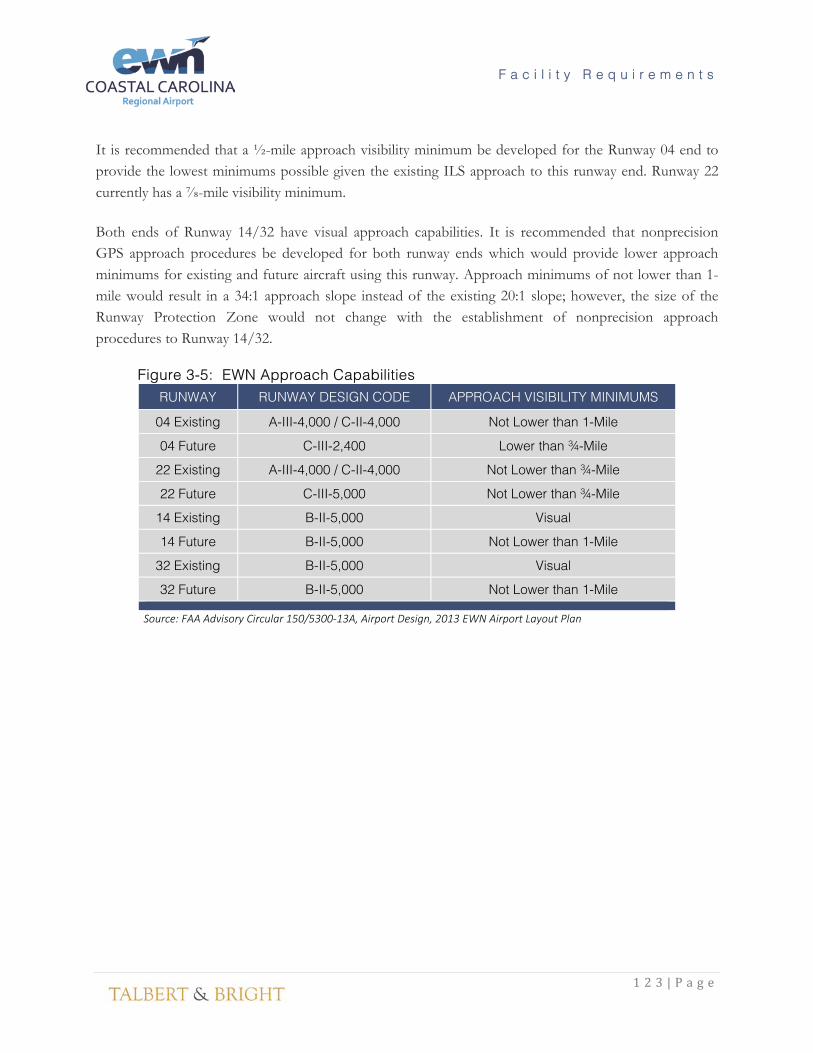
Source: FAA TFMSC Data, TBI Analysis 3.4 Runway Approach Capability Airport design features and sizing/layouts are also determined by the approach visibility minimums for each runway end. These minimums represent ceiling height and visibility; the lower the minimums, the larger the safety areas and separation standards. The existing and proposed approach capabilities are shown in Figure 3-5. Runway 04 currently has an Instrument Landing System (ILS) which is considered a “precision” approach by the FAA. An ILS can provide approach minimums as low as a 200’ ceiling and ½-mile visibility. However, due to the lack of a full approach lighting system and the existing runway-taxiway separation distance and tree obstructions on U.S. Forest Service (USFS) property, Runway 04 has a 1-mile visibility minimum.
F a c i l i t y R e q u i r e m e n t s
1 2 3 | P a g e
It is recommended that a ½-mile approach visibility minimum be developed for the Runway 04 end to provide the lowest minimums possible given the existing ILS approach to this runway end. Runway 22 currently has a ⅞-mile visibility minimum. Both ends of Runway 14/32 have visual approach capabilities. It is recommended that nonprecision GPS approach procedures be developed for both runway ends which would provide lower approach minimums for existing and future aircraft using this runway. Approach minimums of not lower than 1-mile would result in a 34:1 approach slope instead of the existing 20:1 slope; however, the size of the Runway Protection Zone would not change with the establishment of nonprecision approach procedures to Runway 14/32.
Figure 3-5: EWN Approach Capabilities RUNWAY RUNWAY DESIGN CODE APPROACH VISIBILITY MINIMUMS
04 Existing A-III-4,000 / C-II-4,000 Not Lower than 1-Mile
04 Future C-III-2,400 Lower than ¾-Mile
22 Existing A-III-4,000 / C-II-4,000 Not Lower than ¾-Mile
22 Future C-III-5,000 Not Lower than ¾-Mile
14 Existing B-II-5,000 Visual
14 Future B-II-5,000 Not Lower than 1-Mile
32 Existing B-II-5,000 Visual
32 Future B-II-5,000 Not Lower than 1-Mile
Source: FAA Advisory Circular 150/5300-13A, Airport Design, 2013 EWN Airport Layout Plan

F a c i l i t y R e q u i r e m e n t s
1 2 4 | P a g e
3.5 Airport Geometry This section presents the airport geometric design standards and recommendations to ensure the safety, economy, efficiency and longevity of an airport. It is important for airport owners to review both the present and the future uses of the airport and determine if there are any geometric deficiencies that need to be addressed. 3.5.1 Runway Wind Coverage Wind direction determines runway orientation and the subsequent directional use of each runway. The direction of aircraft operations is determined by the prevailing wind at the given time as aircraft generally land and takeoff into the wind. FAA Advisory Circular 150/5300-13A, “Airport Design” recommends 95 percent wind coverage by an airport’s runway configuration. Coverage is determined using historical wind speed and direction data, applying a crosswind component to each runway, and analyzing the percentage of time the crosswind component is below an accepted velocity. The crosswind component is the wind velocity acting at a right angle to a given runway. FAA-accepted crosswind components are as follows:
• 10.5 knots for Runway Design Codes A-I and B-I including A-I and B-I small; • 13 knots Runway Design Codes A-II and B-II; • 16 knots for Runway Design Codes A-III, B-III, and C-I through D-III; and • 20 knots for Runway Design Codes A-IV through D-VI, and E-1 through E-VI.
EWN is classified as an A-III/C-II airport and therefore, a 16-knot crosswind component is used to determine the wind coverage. When analyzing wind coverage, there are three meteorological conditions examined:
• All Weather: All reported ceiling and visibility observations. • Visual Meteorological Conditions (VMC): All observations with greater than 1,000-foot
ceiling and greater than 3.0 miles of visibility. Based on data obtained from the FAA for the period 2007-2016, these conditions occurred 80 percent of the time at EWN.
• Instrument Meteorological Conditions (IMC): All observations with greater than a 200 foot but less than 1,000-foot ceiling and greater than ½ mile but less than 3.0 miles of visibility. Based on data obtained from the FAA for the period 2007-2016, these conditions occurred approximately 20 percent of the time at EWN.
Figure 3-6 lists the calculated wind coverages for each runway at EWN as well as the combined wind coverage for both runways. The existing runway alignments provide greater than 95 percent wind coverage for all crosswind components for All Weather, VMC and IMC conditions.

F a c i l i t y R e q u i r e m e n t s
1 2 5 | P a g e
Figure 3-6: Runway Crosswind Coverage Percentages CROSSWIND
KNOTS VMC CONDITIONS
04/22 14/32 COMBINED
10.5 96.74 92.94 99.55
13 98.42 96.21 99.92
16 99.69 99.27 99.99
20 99.94 99.98 100.00
CROSSWIND KNOTS
IMC CONDITIONS 04/22 14/32 COMBINED
10.5 97.12 93.26 99.42
13 98.54 96.13 99.80
16 99.54 98.93 99.92
20 99.79 99.70 99.98
CROSSWIND KNOTS
ALL WEATHER CONDITIONS 04/22 14/32 COMBINED
10.5 96.85 93.10 99.52
13 98.46 96.25 99.90
16 99.66 99.22 99.98
20 99.91 99.85 99.99
Source: FAA Wind Data: Station 723095 Coastal Carolina Regional Airport annual period record 2007-2016
Based on the wind analysis, the current runway orientations at EWN exceed FAA requirements for wind coverage and an additional crosswind runway is not required at this time. The FAA recommends 10 consecutive years of wind observation data for determining runway wind coverage. A wind rose analysis should be performed periodically to ensure that runway geometry meets the future needs of airport users. 3.5.2 Runway Length Requirements The following section describes the recommended runway length requirements for EWN. The planned, or future, runway length is determined by: 1) Performance requirements to satisfy the most demanding aircraft or family of aircraft utilizing the Airport; 2) Conformance with FAA recommended runway length standards per FAA Advisory Circular (150/5325-4C, Runway Length Recommendations for Runway Design; and 3) Airport and local interest commensurate with community competitiveness for retaining and attracting business and investment to the region.

F a c i l i t y R e q u i r e m e n t s
1 2 6 | P a g e
The FAA provides guidance for all airports receiving federal funding for determining future runway length requirements. As stated in paragraph 301 of AC 150/5325-4C: “The recommended runway length obtained for this category of airplanes (large airplanes and light jets) is based on using the performance charts published by airplane manufacturers (APMs) for individual airplanes.” There are five steps identified in AC 150/5325-4C for determining the require runway length which are listed below.
• Step #1. Identify the critical aircraft takeoff and landing weights.
• Step #2. Identify the critical aircraft flap setting.
• Step #3. Identify airport specific parameters such as runway end elevation changes and mean daily maximum temperature.
• Step #4. Apply the procedures in this chapter to each APM to obtain separate takeoff and
landing runway length recommendations.
• Step #5. Apply any takeoff and landing length adjustments, if necessary, to the resulting lengths. FAA Traffic Flow Management System Counts (TFMSC) data was used to determine the types of aircraft most frequently operating at the airport as well as the most demanding aircraft operating at EWN. This data consists of all aircraft that operated via an instrument flight plan to or from EWN. The most demanding critical aircraft for runway length requirements are comprised of the air carrier aircraft as shown in Figure 3-7. This figure includes the Maximum Takeoff Weight (MTOW) as provided by the manufacturer. This figure also lists the takeoff distance for the most predominant aircraft which is then adjusted to account for the average daily maximum temperature during the hottest month at EWN. Landing distances from the aircraft manufacturer are also included and have been increased by 15 percent to account for wet runway conditions. All takeoff calculations listed in Figure 3-7 assume the aircraft is operating at MTOW.
F a c i l i t y R e q u i r e m e n t s
1 2 7 | P a g e
Figure 3-7: Runway Length Comparison
AIRCRAFT ARC CURRENTLY
OPERATES AT EWN
MTOW (LBS.)
TAKEOFF LENGTH (FT.) ISA
TAKEOFF LENGTH
(FT.) ISA + 15° C
LANDING LENGTH
(FT.)
LANDING LENGTH (FT.) WET (+15%)
Boeing 717-200 C-III No – Delta, Potential 119,000 5,500 7,600 4,700 5,405
Boeing 737-700 C-III No – Delta, Potential 154,500 5,500 8,800 4,700 5,405
Airbus A319 C-III
No – Delta, American, Allegiant Potential
166,000 6,070 7,000 4,700 5,405
Bombardier CS100 C-III
No – Delta, Potential, On Order
134,000 4,000 4,800 4,450 5,118
Embraer 195 C-III No – American, Potential 107,564 5,715 6,000 4,100 4,715
Embraer 190 C-III No – American, Potential 105,359 5,243 5,800 4,100 4,715
Embraer 175 C-III No – Delta/American, Potential
82,673 5,289 6,000 4,600 5,290
Embraer 170 C-III No – Delta/American, Potential
79,344 4,865 5,300 4,100 4,715
Bombardier CRJ-900 C-III Yes – American 84,500 5,775 6,800 5,800 6,670
Bombardier CRJ-700 C-II Yes – American 72,750 5,040 5,300 5,100 5,865
Bombardier CRJ-200 C-II Yes – American,
Delta 53,000 5,800 6,700 4,900 5,635
DeHavilland Dash 8-300/100 B-III Yes – American 43,000 3,870 3,400 2,900 3,335
ATR-42 B-III Yes – FedEx 37,257 3,684 3,800 3,400 3,910
Cessna 208 Caravan A-II Yes - FedEx 8,807 2,160 2,500 1,740 2,001
B-II Business Jets/Turboprops (Cessna Citation Sovereign, Beechcraft King Air 350)
B-II Yes – Part 135 operators 20,200 3,560 3,910 3,310 3,807
Business Jets Larger than B-II
B-III to
D-III
Yes -Private / General Aviation
Up to 90,000 5,990 6,859 2,950 3,393
Source: FAA TFMSC Records, Aircraft manufacturer data.

F a c i l i t y R e q u i r e m e n t s
1 2 8 | P a g e
There were 2,136 operations conducted by the existing Runway 04/22 critical aircraft (CRJ-200) in 2016. This aircraft has a published takeoff runway requirement of 5,800 feet. When adjusted for the hottest temperature, the takeoff distance increases to 6,700 feet. However, the existing runway length of 6,453 feet is not adversely impacting these operations due to the relatively short flight distances between EWN and Atlanta/Charlotte. This allows the aircraft to operate with a reduced fuel load, reducing MTOW and thereby reducing the takeoff length needed. As previously discussed, the airlines are transitioning to larger regional jets such as the CRJ-700 and CRJ-900. The critical aircraft is anticipated to become the CRJ-900 by the year 2021. This aircraft requires 6,800 feet of runway for takeoff when adjusted for temperature. Based on this aircraft performance data, a 347-foot runway extension is recommended for Runway 04/22 at EWN which would result in a 6,800-foot runway. This extension will allow the existing and proposed critical aircraft to operate more efficiently. The extension will also allow these aircraft to depart with additional fuel or payload therefore increasing stage lengths and the potential cities that can be served from EWN. Larger air carrier aircraft such as the Boeing 717, 737, and Airbus A319 may serve EWN within the next 20 years; however, none of these aircraft are anticipated to become the critical aircraft. Notably, these aircraft will be able to operate from the existing and proposed Runway 04/22 lengths with reductions in their payload and/or fuel. A review of category B-II general aviation aircraft indicates that they can operate from a 4,000-foot runway without restrictions. A limited number of larger general aviation aircraft (greater than B-II) operate at EWN. These aircraft typically require a longer runway and therefore, utilize runway 04/22. Operations by these larger aircraft are not anticipated to exceed the critical aircraft threshold of 500 annual operations in the next 20 years. The heaviest B-II aircraft likely to operate from Runway 14/32 is the Cessna Citation Sovereign with a maximum takeoff weight of 30,300 pounds. Runway 14/32 is 4,000 feet long and can accommodate the existing and forecast category B-II aircraft over the next 20 years. No extension is required for this runway. 3.5.3 Runway Numbering Runway numbers are determined by the nearest tenth of a degree in magnetic heading. The constant shifting of magnetic north due to declination change can cause runway designation numbers to change occasionally. The true runway heading plus the magnetic declination for New Bern, NC equals the magnetic runway heading as shown in Figure 3-8. Figure 3-8: Runway Heading/Magnetic Declination
RUNWAY RUNWAY HEADING (TRUE)
MAGNETIC DECLINATION
MAGNETIC RUNWAY HEADING
RUNWAY NUMBERS
04/22 30.71°/210.72° 10.06° 40.77°/220.78° 04/22 14/32 127.93°/307.93° 10.06° 137.99°/317.99° 14/32
Source: FAA AVN Datasheet for EWN (2017), NOAA Magnetic Field Calculator (2017)

F a c i l i t y R e q u i r e m e n t s
1 2 9 | P a g e
The existing runway numbers accurately depict the current (2017) runway magnetic headings and will not need to be altered. It is important to monitor declination changes in the future so that the most accurate magnetic heading may be reflected through the runway designation numbers. 3.5.4 Runway Width FAA Advisory Circular 150/5300-13A provides guidance for runway width standards based on ARC and wind coverage. For Category C-III runways such as 04/22, a 150-foot width is required. Runway 04/22 meets this standard at its current width of 150 feet. For Category B-II (aircraft greater than 12,500 pounds) runways such as 14/32, a 75-foot width is required for visual approaches and approaches with visibility minimums not lower than ¾-mile. Runway 14/32 exceeds this standard with its current 150-foot width. No runway widening will be required over the 20-year planning period. 3.5.5 Pavement Strength and Condition Airport pavements are constructed to provide adequate support for the loads imposed by aircraft using the airport and to produce a firm, stable, smooth, all year, all weather surface, free from dust or other particles that may be blown or picked up by propeller wash or jet blast. For pavements to meet the requirements noted it must have the strength and stability to withstand abrasive action, adverse weather and other deteriorating influences. Braking performance on pavement surfaces becomes critical with increases in forecasted jet operations. Under certain conditions, hydroplaning or unacceptable loss of friction can occur resulting in poor braking performance and possible loss of directional control. Airfield pavement condition is measured using the Pavement Condition Index (PCI) method. Visual inspections of sample areas of the pavement are conducted and entered into MICRO Paver software to determine the numerical PCI rating with 100 being the highest or best condition and 0 being the worst. A pavement condition survey was completed at EWN in 2016 with the results reported in Figure 1-15 of the Inventory chapter of this report. PCI values are also provided at the end of this section in Figure 3-10. The PCI at EWN ranges from a low of 2 to a high of 95. Pavement should be reconstructed when the PCI falls below 40 and overlaid when PCI falls between 40 and 65 for runways and 40 and 60 for taxiways and aprons. The FAA, in conjunction with the International Civil Aviation Organization (ICAO), has developed a standard for reporting the strength of a pavement sections and the ability of those pavements to support a given type of aircraft as identified in FAA Advisory Circular 150/5335-5B Standardized Method of Reporting Airport Pavement Strength - PCN. The Pavement Condition Number (PCN) is determined from the thickness of the existing pavement, California Bearing Ratio (CBR) value of the subgrade, and type and frequency of operations of the most demanding aircraft operating at the airport. An Aircraft Classification Number (ACN) is determined for each type of aircraft operating at a given airport.

F a c i l i t y R e q u i r e m e n t s
1 3 0 | P a g e
If the ACN is less than the PCN for that airport, then the existing pavement will accommodate that aircraft at its maximum takeoff weight. RDM International evaluated existing pavement strength based on current and forecast traffic at EWN. Using the FAA pavement strength program COMFAA, the airfield pavements were evaluated to provide a PCN value for each pavement. In addition, FAA’s computer software FAARFIELD, was used for pavement strength computations based on the FAA’s Advisory Circular 150/5320-6F “Airport Pavement Design and Evaluation” procedures. This analysis provides a cross-check to confirm that the PCN is reasonable. Pavement evaluation traffic used for the analysis of the pavement sections is included in Figure 3-9. It should be noted that the aircraft used in the evaluation of Runway 14/32, Taxiway B, E, K, G and H and the general aviation and air cargo aprons do not include the Boeing 737, CRJ-700 or CRJ-900.
Figure 3-9: Pavement Evaluation Traffic
AIRCRAFT 2016 DEPARTURES 2031 DEPARTURES
Boeing 737-700 0 350
Gulfstream G-650 0 20
Gulfstream G-V 5 6
Canadair Regional Jet CRJ-900 8 700
Canadair Regional Jet CRJ-700 125 2950
Canadair Regional Jet CRJ-200 1300 200
Gulfstream G-IV 22 28
Dassault Falcon 900 1239 1575
Bombardier Dash 8-300 1500 0
Cessna Citation X 618 785
ATR 42-300 263 300
Bombardier Dash 8-100 300 0
Hawker 800 49 60
Learjet 55 47 60
Source: EWN Forecast Operations, Talbert & Bright analysis

F a c i l i t y R e q u i r e m e n t s
1 3 1 | P a g e
Results of the analysis performed by RDM International and a summary of their recommendations for pavement strengthening are as follows:
Runway 04/22. The analysis indicated that Runway 04/22 is structurally adequate for the existing traffic. For the future traffic, most of the pavement is structurally adequate, excluding the northern 800 feet (Runway 22 end) of the runway. It is recommended that this pavement be strengthened by constructing a 3-inch bituminous overlay in the next 5-10 years. The calculated PCN value for Runway 04/22 is 31/F/B/X/T. The corresponding allowable gross aircraft weights are 80,000 lb Single Wheel and 123,000 lb Dual Wheel. The 2016 PCI for Runway 04/22 ranges from 99 to 100. PCI values reflect the runway pavement rehabilitation project completed in 2015. Other than the strengthening recommended to accommodate future aircraft, it is recommended that these existing pavements continue to receive regular maintenance. Taxiway A. The analysis indicated that portions of Taxiway A are not structurally adequate for the existing traffic. These portions include the southern 300 feet and northern 500 feet of the taxiway. The remaining sections of the taxiway are structurally adequate for the existing traffic and portions of the taxiway are structurally adequate for the future traffic. To support current and future aircraft traffic, it is recommended that these two areas be strengthened by constructing a 2 to 2.5-inches bituminous overlay. There is also a 1,300-foot portion of pavement where Taxiway A intersects Runway 14/32 that will require a 2.5-inch bituminous overlay to support future aircraft traffic. It is recommended that the sections of taxiway that are not structurally adequate to support the existing traffic be programmed for strengthening in the 0-5-year timeframe. The 2016 PCI for Taxiway A ranges from 68 to 95. Other than the strengthening recommended in portions of the taxiway to support current aircraft traffic, it is recommended that these existing pavements continue to receive regular maintenance, with attention focused in the areas where PCI values are below 75. Taxiways C, D, J and M. The analysis indicated that Taxiways C, D and J are structurally adequate for the existing and future traffic. Taxiway M is not structurally adequate for the future traffic. To support future aircraft traffic, an additional 3-3.5 inches of bituminous surface course is recommended for Taxiway M.

F a c i l i t y R e q u i r e m e n t s
1 3 2 | P a g e
The 2016 PCI for Taxiway M ranges from 73 to 98. Other than the strengthening recommended in portions of Taxiway M to support future aircraft traffic, it is recommended that these existing pavements continue to receive regular maintenance, with attention focused in the areas where PCI values are below 75.
Air Carrier Apron. The analysis indicated that the Air Carrier Apron is structurally adequate for the existing traffic, but only a portion of the ramp is structurally adequate for the future traffic. Taxiway M is not structurally adequate for the future traffic. To support future aircraft traffic, an additional 3-3.5 inches of bituminous surface course is recommended for this apron. The calculated PCN value for the Air Carrier Apron is 31/F/B/X/T. The corresponding allowable gross aircraft weights are 80,000 lb Single Wheel and 123,000 lb Dual Wheel. The 2016 PCI for the Air Carrier Apron ranges from 49 to 60. For pavements with PCI values below 55, it is recommended that the pavements be rehabilitated. For the terminal apron it is recommended that the apron be reconstructed with a Portland cement concrete pavement and designed to accommodate the future aircraft traffic.
Runway 14/32. The analysis indicated that portions of Runway 14/32 are not structurally adequate for the existing traffic. These portions include the western 625 feet (Runway 14) of the runway and 600 feet portion of the runway west of the intersection with Runway 04/22. It is recommended that these areas be strengthened by constructing a 2 to 3-inch bituminous overlay. The calculated PCN value for Runway 14/32 is 12/F/C/X/T. The corresponding allowable gross aircraft weights are 33,500 lb Single Wheel and 50,000 lb Dual Wheel. The 2016 PCI for Runway 14/32 ranges from 47 to 63. For pavements with PCI values below 55, it is recommended that the pavements be rehabilitated. The 2016 PCI report predicts for Runway 14/32, most of the PCI values will fall below 55 by the year 2020. Continued maintenance of the existing pavement is recommended; however it is anticipated that a pavement rehabilitation, which may include a mill and fill, will be needed in the 5-10 year timeframe.
Taxiways B, E, K, G and H. The analysis indicated that Taxiways B, E, K, G and H are generally not structurally adequate for the existing traffic using these taxiways. To support existing traffic utilizing Taxiway B, it is recommended that the existing bituminous pavement be overlaid with 2 to 3 inches of bituminous pavement. It is recommended that Taxiway E be reconstructed with 4 inches of bituminous surface course constructed on 11 to 14 inches of aggregate base course. Taxiways K, G and H should be strengthened by constructing a 2-inch bituminous overlay.

F a c i l i t y R e q u i r e m e n t s
1 3 3 | P a g e
The 2016 PCIs for Taxiways B, E, K, G and H range from 2 to 79. Most of these pavements have PCI values ranging from 65 to 97. The pavements with very low PCI values (portion of Taxiway B and Taxiway E) are currently programmed to be rehabilitated in 2017. The remaining pavements should continue to receive regular maintained until they are strengthened to accommodate the current aircraft traffic. It should be noted that relocation of the northern portion of Taxiway B is recommended in the 5-10-year time frame to accommodate an instrument approach to Runway 14. If this remains the plan, the existing pavements should be maintained without any major rehabilitation efforts until the relocation occurs.
General Aviation Apron. The analysis indicated that the General Aviation Apron is not structurally adequate for the existing traffic. To support existing traffic utilizing the General Aviation Apron, it is recommended that the existing bituminous apron be overlaid with 2 to 3 inches of bituminous pavement. The 2016 PCI for the General Aviation Apron ranges from 49 to 72. A portion of the General Aviation Apron is programmed to be rehabilitated in 2017. If the remaining pavements are overlaid to provide the recommended strength, this will also address the low PCI values and need for pavement rehabilitation. Air Cargo Apron. To support existing traffic utilizing the Air Cargo Apron, it is recommended that a portion of existing bituminous pavement be overlaid with 2 inches of bituminous pavement. The 2016 PCI for the Air Cargo Apron ranges from 50 to 53. For pavements with PCI values below 55, it is recommended that the pavements be rehabilitated. For the Air Cargo Apron, it is recommended that a pavement rehabilitation, which may include a mill and fill, be performed to extend the useful life of the pavement.
A summary of the pavement strengthening, rehabilitation and reconstruction recommendations based on the 2016 PCI’s reported and the pavement strength calculations performed with this project are shown in Figure 3-10, over the next 20 years.

F a c i l i t y R e q u i r e m e n t s
1 3 4 | P a g e
Figure 3-10: Airfield Pavement Conditions / Recommendations
PAVEMENT LENGTH (FEET)
WIDTH (FEET)
TYPICAL PAVEMENT
CROSS-SECTION
PAVEMENT CONDITION &
AVG. PCI (2016) RECOMMENDATION
Runway 04/22 6,453’ 150’ 6”-7.5” Asphalt
7”-10” Aggregate Base Good
99-100 PCI Strengthen (5-10 years)
Runway 14/32 4,000’ 150’ 4.5”-9.5” Asphalt Fair/Good
47-63 PCI Strengthen/Rehabilitate
(0-5 years)
Taxiway A 6,900’ 50’-95’ 4”-9” Asphalt 6.5”-11” Aggregate Base
Fair/Good 68-95 PCI
Strengthen (0-5 years)
Taxiway B 4,200’ 50’ 3.4”-5” Asphalt 6.5”-12.5” Aggregate Base
Very Poor/Fair 31-59 PCI
Strengthen/Reconstruct/ Rehabilitate (0-5 years)
Taxiway C 300’ 65’ 8” Asphalt 8” Aggregate Base
Sat. 80 PCI
Rehabilitate (5-10 years)
Taxiway D 300’ 65’ 7.3” Asphalt 10” Aggregate Base
Sat. 73 PCI
Rehabilitate (5-10 years)
Taxiway E 1,150’ 35’-50’ 1.3”-3.5” Asphalt 4.2”-10.5” Aggregate Base
Failed/Sat. 2-82 PCI
Reconstruct (0-5 years)
Taxiway F 650’ 40’ 3”-6” Asphalt 6” Aggregate Base
Fair 63-66 PCI
Rehabilitate (0-5 years)
Taxiway G 150’ 50’ 5” Asphalt 5.5” Aggregate Base
Fair 62 PCI
Strengthen/Rehabilitate (0-5 years)
Taxiway H 150’ 50’ 4.5” Asphalt 6.5” Aggregate Base
Sat. 76 PCI
Strengthen/Rehabilitate (0-5 years)
Taxiway J 560’ 75’ 16”-17” Asphalt 7”-8” Aggregate Base
Good 95-98 PCI
Rehabilitate (5-10 years)
Taxiway K 2,500’ 35’ 4”-5” Asphalt 7”-9” Aggregate Base
Fair/Sat. 62-79 PCI
Strengthen/Rehabilitate (0-5 years)
Taxiway L 360’ 35’ 4” Asphalt 8” Aggregate Base
Fair/Sat. 65-75 PCI
Rehabilitate (5-10 years)
Taxiway M 625’ 60’ 3.8”-6” Asphalt 8”-10.3” Aggregate Base
Sat./Good 77-94 PCI
Strengthen (5-10 years)
Terminal Apron
152,000 SF 4 Parking Positions
4”-4.5” Asphalt 8.5”-10.8” Aggregate Base
Poor/Fair 49-60 PCI
Reconstruct (0-5 years)
Cargo Ramp
± 145,000 SF
4”-8” Asphalt 4”-9” Aggregate Base
Poor 50-53 PCI
Strengthen/Rehabilitate (0-5 years)
GA Ramp ± 233,000 SF 52 Tie-Downs
2.4”-5.3” Asphalt 7”-11.6” Aggregate Base
Poor/Satisfactory 49-72 PCI
Strengthen/Rehabilitate (0-5 years)

F a c i l i t y R e q u i r e m e n t s
1 3 5 | P a g e
Source: TBI analysis, RDM International, EWN Records
For reference, the ACN of the aircraft included in Figure 3-9 is provided in Figure 3-11 for a flexible pavement structure for subgrade strength categories at EWN.
Figure 3-11: Airfield Pavement Strength
AIRCRAFT WEIGHT ACN (F/B)
Boeing 737-700 145,000 35
C-130 155,000 34
Embraer E195 115,280 28
Embraer E190 114,200 28
Gulfstream G-650 99,300 31
Gulfstream G-V 92,750 29
Embraer E175 89,000 20
Embraer E170 85,100 20
CRJ-900 84,500 23
CRJ-700 75,000 24
Gulfstream G-IV 75,000 24
CRJ-200 53,000 17
Falcon 900 43.000 12
Dash 8-300 40,000 10
Cessna Citation X 36,300 11
ATR 42-300 35,000 9
Dash 8-100 34,000 8
Hawker 800 30,300 8
Learjet 55 26,430 7
Source: RDM International
Generally, the ACN-PCN system can be used by the airport to determine aircraft operational impacts. When the ACN of an aircraft in question is equal to or less than the pavement’s PCN, the aircraft can be allowed to use the facility without limitations. When PCN is greater than ACN, the “without limitations” use of the aircraft should be interpreted as relative to the evaluation traffic. However, during the lifetime of a pavement, the assigned PCN may be exceeded from occasional aircraft use. For flexible asphalt pavements, occasional use by aircraft with ACN not exceeding 10 percent of the PCN may be allowed.

F a c i l i t y R e q u i r e m e n t s
1 3 6 | P a g e
The rehabilitation measures indicated are provided as guidelines. For pavement strengthening, rehabilitation and reconstruction efforts specific to a pavement at EWN, further analysis will be performed including further subsurface investigation and pavement design efforts. 3.5.6 Runway Protection Zones The Runway Protection Zone’s (RPZ) function is to enhance the protection of people and property on the ground. This is achieved through airport owner control over RPZs. Such control includes clearing RPZ areas (and maintaining them clear) of incompatible objects and activities. Control is preferably exercised through acquisition of sufficient property interest in the RPZ. The geometrics of the RPZ vary depending upon the visibility minimums for the runway approach and the aircraft utilizing the airport as shown in Figure 3-12. Figure 3-12: Approach Runway Protection Zone (RPZ) Dimensions & Design Standards
RUNWAY APPROACH VISIBILITY MINIMUMS
FACILITIES EXPECTED TO
SERVE LENGTH INNER
WIDTH OUTER WIDTH
RPZ ACRES
Runway 04 Existing
Not Lower than 1-Mile * All Aircraft 1,700'
(1,700’)* 500’
(1,000’)* 1,010'
(1,510’)* 29.465
(48.978)* Runway 04 Future
Lower than 3/4-Mile All Aircraft 2,500' 1,000' 1,750' 78.914
Runway 22 Existing
Not Lower than 3/4-Mile All Aircraft 1,700' 1,000' 1,510' 48.978
Runway 22 Future
Not Lower than 3/4-Mile All Aircraft 1,700' 1,000' 1,510' 48.978
Runway 14 Existing Visual Category A & B 1,000' 500’ 700' 13.770
Runway 14 Future
Not Lower than 1-Mile Category A & B 1,000' 500’ 700' 13.770
Runway 32 Existing Visual Category A & B 1,000' 500’ 700' 13.770
Runway 32 Future
Not Lower than 1-Mile Category A & B 1,000' 500’ 700' 13.770
* Note – Minimums will be revised to “Not Lower than ¾-mile” once tree obstructions are removed from Runway 04 approach. Source: Advisory Circular 150/5300-13A, Airport Design; Talbert & Bright analysis Runway 04 is anticipated to have visibility minimums lower than ¾-mile in the future which will expand the existing RPZ from 29.5 acres to 78.9 acres. The existing RPZ for Runway 22 encompasses 48 acres with a visibility minimum of 7/8-mile. The approach minimums are anticipated to increase to 1-mile visibility on the Runway 14/32 ends however; no changes are required for the Runway 14/32 RPZs.

F a c i l i t y R e q u i r e m e n t s
1 3 7 | P a g e
EWN also has Departure RPZs which have dimensional standards equal to or less than the approach RPZ standards. All the departure RPZs either coincide with or fall within the approach RPZs dimensions. No land use changes are required for these departure RPZs other than ensuring that the Airport owns an interest in these land areas to prevent incompatible land uses in the future. 3.5.7 Runway Safety Area A Runway Safety Area (RSA) is defined as a surface surrounding the runway which is suitable for reducing the risk of damage to airplanes in the event of an undershoot, overshoot, or excursion from the runway. The dimensional standards are noted in Figure 3-13. In addition to the dimensional standards, the RSA should conform to the following design standards:
• Graded and cleared of hazardous items or surface variations • Drained by grading or other conveyance to prevent water accumulation • Capable of supporting airport and usage vehicles and the occasional passage of aircraft under dry
conditions • Free from objects except those fixed by function. Objects greater than 3 inches in height above
grade shall be frangible
Figure 3-13: Runway Safety Area (RSA) Dimensions and Design Standards
RUNWAY ARC RSA WIDTH
RSA LENGTH PRIOR TO
THRESHOLD
RSA LENGTH BEYOND
RUNWAY END MEETS DESIGN STANDARDS
04/22 Existing
B-III / C-II 400’ 600’ 1,000’ Yes - with Declared Distances
and RWY 04 EMAS 04/22 Future C-III 400’ 600’ 1,000’ Yes - with RWY 04 EMAS
14/32 Existing &
Future B-II 150’ 300’ 300’ Yes
Source: Advisory Circular 150/5300-13A, Airport Design; Talbert & Bright analysis
There is not enough clear space to accommodate a 1,000-foot safety area beyond the ends of Runway 04/22 due to the proximity of Brice Creek to the southwest and Williams Road to the northeast. Therefore, an Engineered Materials Arresting System (EMAS) was installed on the approach end of Runway 04 which is designed to stop the design aircraft in the event of a runway excursion. AC150/5300-13A allows for a reduced RSA when an EMAS is utilized, as in the case with EWN. Declared distances are used to mitigate the impact of Williams Road on the RSA on the approach end of Runway 22. These declared distances reduce the published Landing Distance Available (LDA) for Runway 04 to 5,753 feet compared to the total runway length of 6,453 feet. Also, the Accelerate Stop Distance Available (ASDA) is reduced for aircraft departing on Runway 04 to 6,053 feet.

F a c i l i t y R e q u i r e m e n t s
1 3 8 | P a g e
The RSA will not change in the future for Runway 04/22 due to the proposed Airport Reference Code increase or the proposed reduction in approach visibility minimums for Runway 04; however, it is recommended that obstacles such as Williams Road be relocated in the near-term (0-5 years) in order to provide full 1,000 foot RSAs beyond the runway ends and eliminate or reduce the declared distances on Runway 04/22. The goal is to make the full length of the runway (6,453 feet) available for takeoff and landing in both directions while meeting FAA RSA standards. Also, relocating these obstacles will also be required to extend the runway to 6,800 feet in 5-10 years as discussed above. 3.5.8 Runway Obstacle Free Zone The Runway Obstacle Free Zone (OFZ) clearing standards preclude taxiing and parked airplanes and object penetrations, except for frangible visual NAVAIDs that need to be in the OFZ because of their function. The runway OFZ, the inner-approach OFZ and the inner-transitional OFZ comprise the obstacle free zone (OFZ). The clearance requirements for the OFZs are defined in AC 150-5300-13A and include:
Runway OFZ. The runway OFZ is a defined volume of airspace centered above the runway centerline. The runway OFZ is the airspace above a surface whose elevation at any point is the same as the elevation of the nearest point on the runway centerline. The runway OFZ extends 200 feet beyond each end of the runway. Its width varies depending on the aircraft being served. At EWN, both runways serve aircraft weighing more than 12,500 pounds and therefore both have a runway OFZ width of 400 feet.
Inner-approach OFZ. The inner-approach OFZ is a defined volume of airspace centered on the approach area and applies only to runways with approach lighting systems which EWN is currently not equipped with. The inner-approach OFZ begins 200 feet from the runway threshold at the same elevation as the runway threshold and extends 200 feet beyond the last light unit in the approach lighting system. Its width is the same as the runway OFZ and rises at a slope of 50 (horizontal) to 1 (vertical) from its beginning. An approach lighting system is recommended for Runway 04. This system will require an inner-approach OFZ which will ensure clear line of sight between the light units and aircraft landing on Runway 04.
Inner-transitional OFZ. The inner-transitional OFZ is a defined volume of airspace along the sides of the runway OFZ and inner-approach OFZ. It applies only to runways with lower than ¾ statute mile approach visibility minimums. Aircraft tails may not violate the inner-transitional OFZ. EWN does not currently have approach minimums low enough to require an inner-transitional OFZ. However, the airspace around Runway 04/22 should be protected so that a
F a c i l i t y R e q u i r e m e n t s
1 3 9 | P a g e
clear inner-transitional OFZ can be provided once approach minimums are lowered to ½-mile in the future. There is no existing or planned inner-transitional OFZ for Runway 14/32 at EWN.
Precision OFZ. The precision OFZ (POFZ) is a defined volume of airspace above an area beginning at the runway threshold, at the threshold elevation, and centered on the extended runway centerline, 200 feet long by 800 feet wide. The surface is in effect only when all of the following operational conditions are met:
• The approach includes vertical guidance. • The reported ceiling is below 250 feet or visibility is less than ¾ statute mile (or Runway
Visual Range (RVR) is below 4,000 feet). • An aircraft is on final approach within two (2) miles of the runway threshold.
When the POFZ is in effect, a wing of an aircraft holding on a taxiway waiting for runway clearance may penetrate the POFZ; however, neither the fuselage nor the tail may infringe on the POFZ. EWN does not currently have approach minimums low enough to require a POFZ. However, the airport should protect a 200-foot by 800-foot clear area adjacent to the end of Runway 04 in preparation for future approach minimums as low as a 250-foot ceiling and ½-mile visibility.
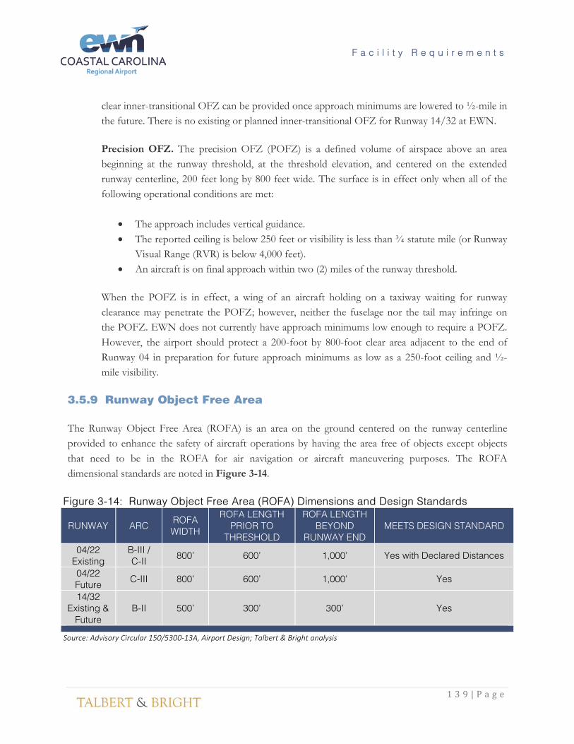
3.5.9 Runway Object Free Area The Runway Object Free Area (ROFA) is an area on the ground centered on the runway centerline provided to enhance the safety of aircraft operations by having the area free of objects except objects that need to be in the ROFA for air navigation or aircraft maneuvering purposes. The ROFA dimensional standards are noted in Figure 3-14.
Figure 3-14: Runway Object Free Area (ROFA) Dimensions and Design Standards
RUNWAY ARC ROFA WIDTH
ROFA LENGTH PRIOR TO
THRESHOLD
ROFA LENGTH BEYOND
RUNWAY END MEETS DESIGN STANDARD
04/22 Existing
B-III / C-II 800’ 600’ 1,000’ Yes with Declared Distances
04/22 Future C-III 800’ 600’ 1,000’ Yes
14/32 Existing &
Future B-II 500’ 300’ 300’ Yes
Source: Advisory Circular 150/5300-13A, Airport Design; Talbert & Bright analysis

F a c i l i t y R e q u i r e m e n t s
1 4 0 | P a g e
Like the RSA, there is not enough clear space to accommodate a 1,000-foot object free area beyond the departure end of Runway 04 due to the proximity of Williams Road to the northeast. Declared distances are used to mitigate the impact of Williams Road on the ROFA which reduce the published Landing Distance Available (LDA) for Runway 04 to 5,753 feet compared to the total runway length of 6,453 feet. Also, the Accelerate Stop Distance Available (ASDA) is reduced for aircraft departing on Runway 04 to 6,053 feet. The ROFA will not change in the future for Runway 04/22 due to the proposed Airport Reference Code increase or the proposed reduction in approach visibility minimums for Runway 04. It is recommended that Williams Road be relocated in 0-5 years to accommodate the full ROFA standards and reduce or eliminate the declared distances. 3.5.10 Runway Line of Sight An acceptable runway profile permits any two points five feet above the runway centerline to be mutually visible for the entire runway length. However, if the runway has a full length parallel taxiway, the runway profile may be such that an unobstructed line of sight will exist from any point five feet above the runway centerline for one-half the runway length. There are no obstructions or limitations to the line of sight within the visibility zone at EWN. No changes are required to meet runway visibility standards. 3.5.11 Runway Edge Lighting and Signage Edge lights are used to outline usable operational areas of airports during periods of darkness and low visibility weather conditions. EWN is currently equipped with High Intensity Runway Lights (HIRL) on Runway 04/22 and Medium Intensity Runway Lights (MIRL) on Runway 14/32 which can be controlled remotely via a Pilot Controlled Lighting (PCL) system. There is no recommended alteration to these lights other than periodic maintenance. Existing airside signage consists of lighted guidance signs. These signs will require periodic maintenance but do not currently need to be replaced or upgraded. 3.5.12 Helipad A helipad designates a specific landing and takeoff area for helicopters. EWN is not currently equipped with a designated helipad. Helicopter operations at the airport consist of aircraft approaching the runway and hover taxiing to the ramp or hangar area. A dedicated helipad is not required at this time however, additional analysis should be performed as rotorcraft operations increase at the airport. 3.5.13 Taxiway Requirements The minimum pavement widths, curve radii, and separations associated with airplane movement areas and airplane physical characteristics establish the taxiway system. Since the taxiway system is the

F a c i l i t y R e q u i r e m e n t s
1 4 1 | P a g e
transitional facility, which supports airport operational capacity, the capability to maintain an average taxiing speed of at least 20 mph is recommended, which is currently met by the existing taxiways at the airport. Taxiway dimensional standards are categorized by separations, widths, curves and fillets. Figure 3-15 summarizes the taxiway dimensional standards. In addition, the taxiway safety area shall be:
• cleared and graded and have no potentially hazardous ruts, humps, depressions, or other surface variations;
• drained by grading or storm sewers to prevent water accumulation; • capable, under dry conditions, of supporting snow removal equipment, aircraft rescue and
firefighting equipment, and the occasional passage of aircraft without causing structural damage for the aircraft; and
• free of objects except those that need to be located in the taxiway safety area because of their function. Objects higher than 3 inches above grade should be constructed on low impact resistant supports (frangible mounted structures) of the lowest practical height with the frangible point no higher than 3 inches above grade. Other objects, such as manholes, should be constructed at grade. In no case should their height exceed 3 inches above grade.
“Hot spots” are areas of intersecting taxiways or runways which may be confusing due to their layout. The FAA identifies known hot spots on the airport diagrams found in the approach procedures charts and airport facility directories. There are no identified hot spots at EWN and all the taxiway intersections adhere to the FAA recommended “three-node concept” by only offering three directional choices for pilots at each intersection. “Direct Access” taxiways, which lead directly from an apron to a runway without requiring a turn should be avoided. Such configurations can lead to confusion when a pilot typically expects to encounter a parallel taxiway but instead accidentally enters the runway. Taxiway F leads directly from a portion of the General Aviation Apron to Runway 4-22. In order to comply with current FAA taxiway requirements, the portion of Taxiway F should be removed between Taxiway K and Runway 4-22. This recommendation will be reflected on the ALP.

F a c i l i t y R e q u i r e m e n t s
1 4 2 | P a g e
Figure 3-15: Taxiway Dimensional Standards
ITEM EXISTING RWY
04/22 TWY DIMENSIONS
TDG 4 / ADG III STANDARDS
EXISTING RWY 14/32 TWY
DIMENSIONS
TDG 2 / ADG III STANDARDS
Taxiway Width 50’ (TWY A) 35’ (TWY K)
50’ (TDG 4) 35’ (TDG II) 35’ to 50’ 35’
Taxiway Edge Safety Margin 10’ 10' 7.5’ 7.5'
Taxiway Centerline to Parallel Taxiway/Taxilane Centerline
210’ (TWY K to TWY E) 152’ 230’ 152’
Taxiway Centerline to Fixed or Movable Object
87’ (TWY A) 187’ (TWY K) 93’ 85’ 93’
Taxilane Centerline to Parallel Taxilane Centerline Not Applicable 140’ Not Applicable 140’
Taxilane Centerline to Fixed or Movable Object 43’ 81’ (ADG III)
39.5’ (ADG I) 160’ 81’
Taxiway Wingtip Clearance 34’ 34’ 34’ 34’
Taxilane Wingtip Clearance 22’ 22’ 22’ 22’
Taxiway Shoulder Width 20’ 20’ 15’ 15’
Taxiway Safety Area Width 102’ (TWY A) 79’ (TWY K)
118’ (ADG III) 79’ (ADG II) 118’ 118’
Taxiway Object Free Area Width 102’ (TWY A) 131’ (TWY K)
186’ (ADG III) 131’ (ADG II) 135.5’ 186’
Taxilane Object Free Area Width 79’ 162’ (ADG III) 79’ (ADG I) 79’ 162’ (ADG III)
79’ (ADG I)
Source: Advisory Circular 150/5300-13A, Airport Design; Talbert & Bright analysis 3.5.14 Parallel Taxiways A basic airport consists of a runway with a full-length parallel taxiway, an apron, and connecting transverse taxiways between the runway, parallel taxiway, and the apron. Both runways at EWN are equipped with full parallel taxiways. Runway 04/22 has Taxiway A along the south side and Taxiway K, a partial parallel taxiway to the north. Taxiway A has seven connection stub taxiways to the runway while Taxiway K is equipped with three connectors. Connector taxiways should permit free flow to the parallel taxiway. The location of connector taxiways depends on the mix of aircraft, approach and touchdown speeds, point of touchdown, exit speed, rate of deceleration, dry or wet pavement, and number of exits. No additional connector taxiways are needed at this time.

F a c i l i t y R e q u i r e m e n t s
1 4 3 | P a g e
3.5.15 Taxiway Edge Lighting and Signage The taxiway edge lighting system is a configuration of lights that define the lateral and longitudinal limits of usable taxiway. Taxiway signage provides the airport users with guidance information for taxiing destinations and to assist in taxi route decision making upon exiting the apron area. EWN is currently equipped with incandescent and LED Medium Intensity Taxiway Lighting (MITL) and lighted taxiway signs. It is recommended that all taxiway lighting be upgraded to LED MITLs due to their efficiency and longer useful life. The airport should consider review and updating the Taxiway designations in accordance with FAA AC 150/5340-18F to provide an Alpha Numeric designation for each taxiway system at the Airport (A1, A2, A3, etc.). 3.5.16 Runway to Taxiway Separation Runway to taxiway separation standards are predicated on the Airport Reference Code (ARC) and the existing/future visibility minimums expected. The higher the ARC and the lower the visibility minimums, the greater the runway to taxiway separation distances. At EWN, FAA AC 150-5300-13A requires a 300-foot separation for Runway 04/22 (ARC B-III/C-II) with visibility minimums not lower than 1-mile. This requirement increases to 400 feet of separation if approach minimums are lowered to less than ¾-mile or the reference code increases to C-III which is likely to occur in the next five years. The southern parallel taxiway for this runway (Taxiway A) is currently located at 400 feet and meets existing and future design standards. However, partial parallel Taxiway K on the north side is located at 320 feet from the runway centerline. It is recommended that this taxiway be relocated or removed once the reference code increases to C-III. Runway 14/32 (ARC B-II) requires a 240-foot separation with visual and not lower than 1-mile approach minimums. Parallel Taxiway B is located 200 feet from the Runway 14/32 centerline between Runway 04/22 and the end of Runway 14. The remaining portion of parallel Taxiway B is located 240 feet from the runway centerline. No changes in reference code are anticipated for this runway however, Taxiway B should be relocated in 5-10 years so that the entire taxiway is 240 from the runway centerline to meet FAA standards. Also, any future parallel taxiways on the west side of this runway should be constructed at least 240 feet from the runway centerline. 3.5.17 Taxiway and Taxilane Object Free Areas The taxiway and taxilane OFAs are centered on the taxiway and taxilane centerlines. The taxiway and taxilane OFA clearing standards prohibit service vehicle roads, parked airplanes, and above ground objects except for objects that need to be in the OFA for air navigation or aircraft ground maneuvering purposes. Vehicles may operate within the OFA provided they give right of way to oncoming aircraft by either maintaining a safe distance ahead or behind the aircraft or by exiting the OFA to let the aircraft

F a c i l i t y R e q u i r e m e n t s
1 4 4 | P a g e
pass. The taxiway OFA for Taxiway A is currently 102 feet wide due to a fence located south of the taxiway near the old terminal building parking lot. The requirement for ADG III is for a 186-foot-wide OFA. It is recommended that the fence be relocated in the near term to meet the OFA requirement. 3.5.18 Taxilane System Taxilanes are typically used for maneuvering aircraft on aprons and between hangars. The asphalt taxilanes in the GA area of the airport are 20 feet to 30 feet wide and are in fair condition. The distance between hangars on either side of these taxilanes varies from approximately 70 feet to more than 90 feet. It is recommended that all future taxilanes be designed to meet either group I or group II taxilane OFA width depending upon the wingspan of the aircraft that will be using them. The taxilane strength should be commensurate with aircraft usage as needed between the airfield and associated hangar/ramp maneuvering areas. Hangar taxilanes should be of sufficient width to allow unencumbered wingtip clearance between fixed objects (hangars, fence, fueling facilities, light poles, etc.). There are no other modifications or improvements required at this time to the taxilane network at EWN. Figure 3-16 and 3-17 summarize the existing and future runway dimensions and design standards for Runways 04/22 and 14/32 respectively. Deficiencies from design standards are noted in red. The deficiencies associated with Runway 04/22 include the lack of a full 1,000-foot RSA and ROFA beyond the runway ends. This is due to the proximity of Brice Creek near the Runway 04 end and Williams Road near the Runway 22 end. To mitigate the lack of full RSAs and ROFAs, declared distances are used to reduce the available Accelerate Stop Distance Available (ASDA) and Landing Distance Available (LDA) which reduces the useable runway length for takeoff and landing calculations. Also, the EMAS systems installed on the Runway 04 end reduces the RSA requirements by providing a system for stopping the runway critical aircraft in the event of a runway overrun. The approach RPZ for Runway 04 will increase in size when visibility minimums lower than ¾-mile are implemented. The airport currently owns a portion of the existing Runway 04 RPZ with the remaining areas owned by the USFS. The FAA recommends that airports acquire an interest in the property falling within existing and future RPZs however, due to this property being owned by USFS, and an existing agreement between EWN and this agency for the removal of obstructions as necessary, acquisition of this land by the Airport is not recommended at this time.

F a c i l i t y R e q u i r e m e n t s
1 4 5 | P a g e
Figure 3-16: Runway 04/22 Design Standards
ITEM EXISTING
ARC B-III / C-II Requirements
(Not Lower than 3/4-mile Visibility)
ARC C-III Requirements
(Not Lower than 3/4-mile Visibility)
ARC C-III Requirements
(Lower than 3/4-mile Visibility)
RWY 04 / RWY 22 RWY 04 / RWY 22 RWY 04 / RWY 22 RWY 04 / RWY 22
Runway Width 150’ 100’ 150’ 150’
Runway Safety Area (RSA)
Length beyond departure end 600’ / 333’ (EMAS) 1,000’ / 1,000’ 1,000’ / 1,000’ 1,000’ / 1,000’
Length prior to runway threshold 600’ / 600’ 600’ / 600’ 600’ / 600’ 600’ / 600’
Width 400’ 400’ 400’ 400’
Runway Object Free Area (ROFA)
Length beyond runway end 600’ / 333’ (EMAS) 1,000’ / 1,000’ 1,000’ / 1,000’ 1,000’ / 1,000’
Length prior to runway threshold 600’ / 600’ 600’ / 600’ 600’ / 600’ 600’ / 600’
Width 800’ 800’ 800’ 800’
Runway Obstacle Free Zone (ROFZ)
Length beyond runway end 200’ 200’ 200’ 200’
Width 400’ 400’ 400’ 400’
Precision Obstacle Free Zone (POFZ)
Length None / None None / None None / None 200’ / None
Width None / None None / None None / None 800’ / None
Approach Runway Protection Zone (RPZ)
Length 1,700’ / 1,700’ 1,700’ / 1,700’ 1,700’ / 1,700’ 2,500’ / 1,700’
Inner Width 500’ / 1,000’ 500’ / 1,000’ 500’ / 1,000’ 1,000’ / 1,000’
Outer Width 1,010’ / 1,510’ 1,010’ / 1,510’ 1,010’ / 1,510’ 1,750’ / 1,510’
Size (acres) 29.465 / 48.978 29.465 / 48.978 29.465 / 48.978 78.914 / 48.978
Departure Runway Protection Zone (RPZ)
Length 1,700’ / 1,700’ 1,700’ / 1,700’ 1,700’ / 1,700’ 1,700’ / 1,700’
Inner Width 500’ / 500’ 500’ / 500’ 500’ / 500’ 500’ / 500’
Outer Width 1,010’ / 1,010’ 1,010’ / 1,010’ 1,010’ / 1,010’ 1,010’ / 1,010’
Size (acres) 29.465 / 29.465 29.465 / 29.465 29.465 / 29.465 29.465 / 29.465
Runway centerline to:
Holding Position 250’ 250’ 250’ 250’
Parallel Taxiway/Taxiway centerline 320’ 300’ 400’ 400’
Aircraft Parking Area 500’ 400’ 500’ 500’

F a c i l i t y R e q u i r e m e n t s
1 4 6 | P a g e
Figure 3-17: Runway 14/32 Design Standards
Source: Advisory Circular 150/5300-13A, Airport Design; Talbert & Bright analysis
ITEM EXISTING ARC B-II Requirements (Visual & Not Lower than 1-Mile Visibility)
RWY 14 / RWY 32 RWY 14 / RWY 32
Runway Width 150’ 75’
Runway Safety Area (RSA)
Length beyond departure end 300’ / 300’ 300’ / 300’
Length prior to runway threshold 300’ / 300’ 300’ / 300’
Width 150’ 150’
Runway Object Free Area (ROFA)
Length beyond runway end 300’ / 300’ 300’ / 300’
Length prior to runway threshold 300’ / 300’ 300’ / 300’
Width 500’ 500’
Runway Obstacle Free Zone (ROFZ)
Length beyond runway end 200’ 200’
Width 400’ 400’
Precision Obstacle Free Zone (POFZ)
Length None / None None / None
Width None / None None / None
Approach Runway Protection Zone (RPZ)
Length 1,000’ / 1,000’ 1,000’ / 1,000’
Inner Width 500’ / 500’ 500’ / 500’
Outer Width 700’ / 700’ 700’ / 700’
Size (acres) 13.770 / 13.770 13.770 / 13.770
Departure Runway Protection Zone (RPZ)
Length 1,000’ / 1,000’ 1,000’ / 1,000’
Inner Width 500’ / 500’ 500’ / 500’
Outer Width 700’ / 700’ 700’ / 700’
Size (acres) 13.770 / 13.770 13.770 / 13.770
Runway Centerline to:
Holding Position 130’ 200’
Parallel Taxiway/Taxiway centerline 200’ 240’
Aircraft Parking Area 295’ 250’
F a c i l i t y R e q u i r e m e n t s
1 4 7 | P a g e
3.6 Aircraft Parking and Storage Requirements This section identifies airfield facilities needed to satisfy the 20-year forecast of aviation demand at EWN. The identification of needed facilities does not constitute a requirement in terms of absolute design standards or goals, but rather an option for facility improvements to resolve various types of facility or operational inadequacies, or to make improvements as demand warrants. The facilities recommended as part of AMPU have been identified from inventory and forecast findings and planned in accordance with FAA airport design standards and airspace criteria. 3.6.1 Commercial Aircraft Parking and Storage The air carrier terminal apron currently encompasses 152,000 square feet (16,890 SY), including taxilane ingress and egress, and has four dedicated aircraft parking positions. These positions are approximately 100 feet wide and can accommodate four CRJ-200 aircraft simultaneously. They are located so that these aircraft pushback with a tug. The existing positions will accommodate up to an Embraer ERJ-190 aircraft (94.3-foot wingspan). Currently, two CRJ-200/700 series aircraft are parked at the gates overnight at EWN. These aircraft are considered “Remain Overnight” (RON) aircraft at EWN and are used for the first morning flights out of EWN. As air carrier operations grow at EWN, additional apron space may be needed to accommodate future RON aircraft. It is recommended to expand the apron in the 0-5-year timeframe by 10,000 SY to allow for larger and reoriented parking positions which can accommodate occasional 737-700 aircraft (117.5-foot wingspan) and to accommodate up to two additional RON regional jet aircraft.. This expansion will also allow additional regional jets to be parked on the apron during times of overlapping commercial operations. The reoriented parking positions should be aligned to allow for future jet bridges to serve the two closest parking positions to the terminal building. 3.6.2 General Aviation Aircraft Parking and Storage General aviation aircraft parking and storage requirements can vary widely from airport to airport depending on the number of transient aircraft using the airport and the number of based aircraft owners who chose to tie down their aircraft on the ramp versus those who choose to use hangars. Figure 3-18 lists the existing storage percentages at EWN by aircraft type.

F a c i l i t y R e q u i r e m e n t s
1 4 8 | P a g e
Figure 3-18: Based Aircraft Storage Ratios
AIRCRAFT TYPES APRON TIEDOWNS T-HANGARS CONVENTIONAL HANGARS
Single-Engine Piston 10% 70% 20%
Multi-Engine Piston 30% 0% 70%
Multi-Engine Turbine 0% 0% 100%
Business Jet 0% 0% 100%
Rotorcraft (Helicopters) 0% 0% 100%
Source: EWN Records Transient aircraft parking requirements typically make up the largest demand for apron space. Transient aircraft are defined as those aircraft not based at EWN. The transient aircraft storage ratios are shown in Figure 3-19.
Figure 3-19: Transient Aircraft Storage Ratios AIRCRAFT TYPES APRON TIEDOWNS T-HANGARS CONVENTIONAL HANGARS
Single-Engine Piston 90% 10% 0%
Multi-Engine Piston 80% 0% 20%
Multi-Engine Turbine 70% 0% 30%
Business Jet 70% 0% 30%
Rotorcraft (Helicopters) 60% 0% 40%
Source: EWN Records
Airports most often utilize T-Hangars as covered storage for small general aviation aircraft. The name of the hangars is derived from their “T” shape. A series of T-Hangars are typically nested together under one common roof. EWN currently has seven T-Hangar buildings with a total of 50 individual storage units as shown in Figure 3-20. There are currently 72 based single-engine aircraft at EWN with approximately 70% stored in T-Hangars. The number of single-engine aircraft is projected to decrease from 72 to 65 over the next 20 years which would mean that the existing number of T-Hangars is sufficient for meeting demand over the 20-year planning period. However, there is currently a waiting list for T-Hangar storage and some aircraft currently stored on the apron may relocate to a T-Hangar is given the option. Therefore, EWN should plan for the addition of one 10-unit T-Hangar over the next 20 years to ensure that demand for this type of storage can be met.

F a c i l i t y R e q u i r e m e n t s
1 4 9 | P a g e
Figure 3-20: T-Hangar Aircraft Storage Requirements
YEAR SINGLE-ENGINE
MULTI-ENGINE
TURBOPROP / JET HELICOPTER TOTAL
2017 50 0 0 0 50
2022 48 0 0 0 48
2027 47 0 0 0 47
2036 46 0 0 0 46
Source: Talbert & Bright analysis Conventional hangars represent the other most common method of covered aircraft storage. The following represents the FAA-accepted calculations for conventional hangar storage:
• Single-Engine – 850 square feet • Multi-Engine – 1,200 square feet • Jet – 2,900 square feet • Helicopter – 1,500 square feet
The existing conventional hangar storage area at EWN totals approximately 66,500 square feet. Roughly 20 percent of the single-engine aircraft are stored in conventional hangars while 70 percent of multi-engine aircraft are stored in these same hangars. All turboprop, jet, and helicopters are considered stored in conventional hangars due to the value of these aircraft. When these ratios are applied to the based and transient aircraft forecasts, the result indicates a need for approximately 37,100 square feet of conventional hangar storage by the year 2036. A total of nearly 71,250 square feet of conventional hangar storage will be needed by 2036 for aircraft storage as shown in Figure 3-21.
Figure 3-21: Conventional Hangar Aircraft Storage Requirements
YEAR BASED AIRCRAFT STORAGE (square feet) TRANSIENT
AIRCRAFT STORAGE
TOTAL SINGLE-ENGINE
MULTI-ENGINE
TURBOPROP / JET HELICOPTER
2016 12,240 2,520 8,700 3,000 10,643 37,103
2021 11,560 2,520 14,500 4,500 11,460 44,540
2026 11,390 2,520 17,400 4,500 12,379 48,189
2031 11,050 2,520 26,100 7,500 13,582 60,752
2036 11,050 2,520 31,900 10,500 15,280 71,250
Source: Talbert & Bright analysis

F a c i l i t y R e q u i r e m e n t s
1 5 0 | P a g e
Apron areas are used for outside aircraft storage. Approximately 10 percent of single-engine and 30 percent of multi-engine-based aircraft are stored on these apron areas. The following represents the FAA-accepted calculations for apron area storage:
• Single-Engine – 870 square yards • Multi-Engine – 960 square yards • Jet – 2,540 square yards
These calculations account for the ingress and egress of aircraft to and from the apron parking spaces. The existing GA apron areas at EWN total roughly 25,880 square yards. Approximately 27,200 total square yards of apron space will be needed by 2036 to accommodate based and transient aircraft. This results in an additional 1,320 square yards of apron space required for by 2036 as shown in Figure 3-22.
Figure 3-22: General Aviation Apron Storage Requirements
YEAR BASED AIRCRAFT STORAGE (square yards) TRANSIENT
AIRCRAFT STORAGE
TOTAL SINGLE-ENGINE
MULTI-ENGINE
TURBOPROP / JET HELICOPTER
2016 6,264 864 0 0 14,395 21,523
2021 5,916 864 0 0 15,501 22,281
2026 5,829 864 0 0 16,744 23,437
2031 5,655 864 0 0 18,371 24,890
2036 5,655 864 0 0 20,667 27,186
Source: Talbert & Bright analysis 3.7 Airport Ancillary Facility Requirements 3.7.1 Fueling Facilities The Airport has experienced steady growth in AvGas and Jet A sales in recent years. Existing fuel storage facilities and fuel tanker trucks are listed below.
• One 20,000-gallon Jet A above ground steel single-walled storage tank • One 12,000-gallon AvGas (100LL) above ground steel single-walled storage tank • One 520-gallon Off-road Diesel above ground steel single-walled storage tank • One 2,200-gallon Jet A truck • One 3,000-gallon Jet A truck • One 1,000-gallon AvGas (100LL) truck

F a c i l i t y R e q u i r e m e n t s
1 5 1 | P a g e
The fuel farm meets Environmental Protection Agency (EPA) containment requirements and is in good condition. As airlines switch to larger commercial aircraft over the next 20 years and as general aviation jet traffic increases, additional Jet A fuel storage may be necessary at EWN. There is sufficient space adjacent to the existing fuel farm for an additional 20,000-gallon Jet A tank and expanded containment area. Consideration should also be given to the possibility of relocating the Fuel Farm to an area off of Aviation Drive to allow hangar development similar to the existing development at the current fuel farm location. This relocated fuel farm would provide better access for fuel tanker deliveries, provide a more direct access for fuel trucks to the General Aviation Apron, and move the fuel farm away from the hangar development area. If the opportunity presents itself, the airport may also consider constructing a second fuel farm within the commercial service terminal area with Jet-A tanks to only serve the air carrier traffic. This would eliminate the need for aircraft to travel across the airfield from the existing fuel farm location to the commercial service ramp, providing a more efficient operation. 3.7.2 Airport Electrical Vault The airfield electrical vault is located near the base of the Control Tower north of the general aviation ramp. The vault houses the airfield lighting regulators and serves as the distribution point for the Airport’s three-phase power and is in good condition. No changes to this equipment are needed at this time however, as additional facilities are constructed at the airport, upgrades may need to be considered including supplemental/additional power feeds to the airport. 3.7.3 Airfield Maintenance Equipment and Storage Facilities Airfield maintenance equipment is stored and maintained in a 3,340-square foot three-bay garage located adjacent to the Aircraft Rescue and Firefighting (ARFF) building and a 900-square foot building adjacent to the air cargo facility. Maintenance equipment is also stored on the east side of and adjacent to the terminal apron. This equipment includes various tractors, mowers, brush hogs and pickup trucks. An expanded or relocated airfield maintenance equipment storage facility is recommended in the near-term to provide covered storage for this equipment as well as an expanded workshop/repair facility. A 4,000 SF to 5,000 SF facility with multiple bays and roll-up garage doors is recommended. 3.7.4 Airport Rescue and Fire Fighting (ARFF) Facility EWN is a certified CFR Part 139 commercial service airport and is this required to have on-site ARFF equipment. The level of air carrier service provided at an airport determines the ARFF requirements. EWN is a Class I Part 139 Airport which is defined by 14 CFR Part 139 as “an airport certificated to

F a c i l i t y R e q u i r e m e n t s
1 5 2 | P a g e
serve scheduled operations of large air carrier aircraft that can also serve unscheduled passenger operations of large air carrier aircraft and/or scheduled operations of small air carrier aircraft.” The Airport has an ARFF index of “A” which is based on the longest aircraft with an average of five or more daily departures. Index A includes commercial service aircraft less than 90-feet in length. An airport with an ARFF Index A must have the following firefighting equipment:
(1) 500 pounds of sodium-based dry chemical, halon 1211, or clean agent; or
(2) 450 pounds of potassium-based dry chemical and water with a commensurate quantity of Aqueous Film Forming Foam Agent (AFFF) to total 100 gallons for simultaneous dry chemical and AFFF application.
The critical aircraft at EWN is anticipated to change to the CRJ-900 within the next 10 years and to have more than 5 daily departures. The CRJ-900 has a 118.9 feet length which would require the ARFF index at EWN to increase to a level “B” which requires:
(1) 1,500 gallons of water with a commensurate quantity of AFFF; and
(1) 500 pounds of sodium-based dry chemical, halon 1211, or clean agent; or
(2) 450 pounds of potassium-based dry chemical and water with a commensurate quantity of
AFFF to total 100 gallons for simultaneous dry chemical and AFFF application. EWN is currently equipped with a 2005 E-One firetruck with 1,500 gallons of water, 300 gallons of foam, and 500 gallons of dry chemical. This vehicle meets Index “B” requirements however, it will likely reach the end of its service life within the next 10 years and should be replaced with an ARFF vehicle meeting or exceeding the current capabilities. EWN does not currently have an ARFF facility. The Airport’s ARFF truck is stored in a 1,160-square foot single-bay ARFF garage located adjacent to the terminal building. A portion of the terminal is dedicated to ARFF equipment and vehicle storage. FAA AC 150/5210-15A indicates that the primary responsibility and objective of an ARFF and emergency service organization is to provide a timely response, protect life and property and minimize the effects of an aircraft accident, incident or catastrophic event occurring primarily on airport property. The key to the successful execution of this role can be achieved by optimizing the location of the airport fire station and designing the station to enhance effectiveness and efficiency of emergency services personnel.

F a c i l i t y R e q u i r e m e n t s
1 5 3 | P a g e
The current facilities at EWN are not optimally sized or located on the Airfield. In the event of an incident on the airfield, ARFF personnel located inside the terminal building are required to obtain equipment at one location within the terminal building and access the ARFF vehicle in a bay that is not adequately sized and access to the airfield requires multiple turns in order to reach Runway 4-22. In the event of an incident on the land side, no direct access from the ARFF vehicle storage bay is provided. The layout and location of the different ARFF functions is not efficient for emergency service in the event of an incident. Providing an ARFF facility that is designed to provide operational efficiency is essential in minimizing the time necessary to respond to an aircraft related event. It is recommended that the ARFF equipment and vehicles be consolidated into one facility located on the south side of the terminal building which will provide access directly from the ARFF bay onto the Air Carrier Apron and allow the ARFF truck to drive straight onto Runway 4-22. This location would also provide direct ARFF access to the terminal loop roadway. The proposed ARFF facility would be designed in accordance with FAA AC 150/5210-15A and should at a minimum provide the following station elements:
• Two properly sized Apparatus Bays to park the ARFF vehicles, providing both airside and landside access from each bay. The bay should be designed at a minimum to accommodate two Class IV 1,500 gallon ARFF vehicles with a length of 35’ and width of 10.2’. Bays this size will accommodate the current EWN ARFF vehicle which is a 1995 E-ONE Titan 4x4 with 1,500 gallons of water storage. Typically, the number of bays eligible for FAA AIP funding is proportional to the number of ARFF vehicles required given the ARFF index of the airport. EWN is currently equipped with one ARFF truck however; the ARFF index is anticipated to increase from A to B within the next 10 years at EWN as larger regional jets replace smaller jets operating at the Airport. FAA A/C 150/5210-15A states: “The question of how many bays are eligible is often predicated on the airport’s ARFF Index plus one bay for light maintenance and washing”. FAA Order 5100.38D indicates that a maintenance bay may be eligible within an ARFF building if all of the requirements for maintenance facilities in Table O-3 are met. EWN does not currently have a maintenance or service facility for maintaining required safety and security equipment. Therefore, two bays, one for ARFF vehicle storage and one for maintenance are recommended for EWN.
• Watch/Alarm Room to provide a central point for receiving emergency calls, dispatching ARFF vehicles and mobilizing other support resources. This room provides at least 130 square feet in accordance with FAA A/C 150/5210-15A.
• Bay Support to provide adequate Equipment and Material Storage space. A minimum of 375 square feet will be allocated for emergency response equipment storage including

F a c i l i t y R e q u i r e m e n t s
1 5 4 | P a g e
self-contained breathing apparatus (SCBA), hose reel, turnout complimentary firefighting agent storage.
• Support facilities including Training Room, Sleep Rooms, First Aid and Medical Storage, Kitchen/Day Room, Restroom/Locker facilities, and other necessary facilities to support personnel required to provide ARFF operations. These facilities should be designed to the following approximate square footages per FAA A/C 150/5210-15A:
o Training Room – 500 square feet
o Sleep Rooms / Dormitories – 300 square feet (150 sf per room)
o Kitchen/Dining – 210 square feet
o Day Room – 206 square feet
o Restrooms and Locker rooms – Men’s and Women’s facilities
o Laundry room – 90 square feet
o First Aid – 80 square feet
o Medical Storage – 180 square feet
o Administrative Office – 190 square feet
• Concrete apron should be constructed on the airside between the ARFF Apparatus Bays and the Aircraft Parking Apron to provide direct access to the Airfield. The apron will be designed to hold at least two ARFF vehicles in front of the storage bays. Therefore, the recommended ARFF apron size is at least 2,500 square feet which will accommodate the future ARFF vehicle requirements.
3.7.5 Air Traffic Control Tower While the existing tower facility is still in operation, it is expected that a significant level of maintenance will be required in the next few years to maintain a safe and operational facility. Due to the age and condition of the existing Air Traffic Control Tower (45+ years), the airport should consider a major renovation or replacement of the tower. A review of the tower siting should be performed to confirm that the current location of the tower is optimal or options for relocating the tower should be reviewed. 3.7.6 Perimeter Fencing Perimeter fencing is crucial to the prevention of animal and human incursion on aircraft operating areas. EWN is encircled by 6-foot and 8-foot chain-link fence with three-strand barbwire in accordance with CFR Part 139 requirements. The Airport fence should be adjusted so that the airfield remains secure when additional facilities such as hangars are constructed. Also, there are portions of fence located
F a c i l i t y R e q u i r e m e n t s
1 5 5 | P a g e
within the Taxiway Safety Area and Taxiway Object Free Area south of Taxiway A and near the old terminal automobile parking lot. It is recommended that this fence be relocated in 0-5 years so that it is located outside of these clearance areas. The airfield fencing is in satisfactory/good condition and will require periodic maintenance during the planning period. It is recommended that all areas at EWN equipped with a 6-foot fence, be replaced with an 8-foot fence that meets CFR Part 139 standards. Also, a 10 to 15-foot clear area should be maintained inside and outside of the fence for access to all areas of the fence line. 3.8 Airspace and NAVAID Requirements It is important to analyze the existing airspace surrounding EWN and how it impacts aircraft approaching or departing from the Airport. It is also important to identify existing and potential obstructions to the airspace surfaces in the immediate vicinity of the Airport. This section discusses the airspace around the Airport from both perspectives. The ability for EWN to obtain ½-mile visibility approach minimums to Runway 04 will be determined by land use and obstruction constrains as well as the airspace surrounding the Airport as discussed below. The recommendations represent ideal airport enhancement which may not be practical or obtainable due to these limitations. 3.8.1 Airspace Capacity As discussed in the Inventory Chapter of this document, EWN lies within Class D airspace due to the presence of an air traffic control tower at the Airport. The Airport lies within a relatively congested area of airspace due to the proximity of Marine Corps Air Station (MCAS) Cherry Point to the southeast and MCAS New River to the southwest. Also, Marine Corps Outlying Filed Oak Grove is located east of EWN with traffic transitioning between MCAS Cherry Point and MCAS New River. It is recommended that existing and future precision (ILS) approaches to EWN be conducted on Runway 04 due to the proximity of the City of New Bern immediately north of EWN. No additional airspace constraints are anticipated over the 20-year planning period. 3.8.2 Instrument Landing System As discussed in the Inventory Chapter, EWN is equipped with a Category I Instrument Landing System (ILS) approach to Runway 04 with horizontal and vertical guidance and visibilities minimums as low as 1-mile. This system can provide approach minimums as low as a 200-foot ceiling and ½-mile visibility. However, to achieve these minimums, the Airport must be equipped with an approach lighting system, provide an obstruction-free approach clearance slope, and meet the FAA airfield dimensional

F a c i l i t y R e q u i r e m e n t s
1 5 6 | P a g e
requirements associated with these minimums. The existing localizer antenna and glideslope antenna provide the ground-based navigation aid requirements and will not need to be replaced during the planning period. These facilities will require periodic maintenance and FAA flight inspection to ensure that they are functioning properly. No additional ILS system is planned for any of the remaining Runway ends at EWN due to land use and obstruction restrictions associated with these ends. 3.8.3 Visual Guidance Lighting System The Precision Approach Path Indicator (PAPI) is a lighted instrument that provides electronic visual guidance to the pilot to allow vertical guidance to the runway end. The PAPI provides accurate guidance with one set of lights which indicate different slopes: above, on course, or below the glide slope. It is recommended that PAPIs be installed on each end of an instrument runway or where maintaining vertical guidance is necessary (such as over populated areas). Four-box PAPIs are currently installed on both ends of Runway 04/22 and two-box PAPIs on both ends of Runway 14/32 at EWN. These PAPI lights provide a 3° glide path to all runway ends at EWN except for Runway 14 which has a 4° glide path. An obstruction clearance plane is required for the PAPIs. This surface extends 4 nautical miles from the runway touchdown point at a slope of 1° per 50' which is 1° less than the lowest on-course aiming angle of 2° 50' (3° 50' for Runway 14). The Runway 14 PAPI glide path should be lowered to the standard 3° once obstructions to this runway end are removed. No other improvements are needed to the existing PAPIs at EWN other than periodic maintenance. There are currently no runway approach lighting systems at EWN. To achieve ½-mile visibility approach minimums to Runway 04, a full approach lighting system is recommended on the Runway 04 end in 0-5 years such as a Medium Intensity Approach Lighting System with Runway Alignment Indicator Lights (MALSR). This system assists pilots in determining the centerline of the runway and is required for a precision approach. The FAA defines the MALSR as a system consisting of a combination of threshold lamps, steady burning light bars and flashers, provides visual information to pilots on runway alignment, height perception, roll guidance, and horizontal references for Category I precision approaches. No additional approach lighting upgrades other than the MALSR are anticipated over the 20-year planning period. 3.8.4 Weather Reporting System EWN is equipped with an Automated Surface Observing System (ASOS) which provides real-time weather information to pilots operating at the Airport. This system provides up to the minute temperature, precipitation, wind speed & direction, ceiling, pressure, and visibility. The ASOS is located near the approach end of Runway 04 and has a dedicated radio frequency and phone line allowing pilots to access the weather data 24/7. A Runway Visual Range (RVR) sensor measures ambient light intensity and is used to determine visibility at the Airport. An RVR sensor is currently located near the approach

F a c i l i t y R e q u i r e m e n t s
1 5 7 | P a g e
end the precision approach runway (Runway 04). It is recommended that an additional RVR sensor be installed near the approach end of Runway 22 to provide visibility readings to aircraft landing on this runway end. The ASOS system is expected to accommodate the forecast weather information demand for the 20-year planning period. 3.9 Terminal, Auto Parking, And Access Requirements The following section discusses the Landside Facility Requirements at EWN including the terminal building, automobile parking, and ground access. The facilities recommended have been identified from inventory and forecast findings and planned in accordance with FAA airport design standards. 3.9.1 Terminal Building The Airport terminal facility serves as the focal point of an airport and represents the front-door to the community for arriving passengers. The existing terminal building at EWN was constructed in 1999 and provides approximately 40,380 square feet of space. As part of the AMPU, a terminal utilization and condition analysis was performed by the Wilson Group architects. This report identified terminal improvements recommendations over the planning period. These improvements are based on existing facility conditions, building codes, and existing and forecast air carrier operations and enplanements. The terminal improvements are primarily associated with current building code conditions and reallocating space within the terminal to meet future demand. The terminal was designed prior to 9/11 and does not offer adequate space for the security checkpoint. Also, the holdroom should be expanded to allow for the accommodation of additional passengers during overlapping flights and to accommodate the projected larger air carrier aircraft that will be using EWN in the future. The primary terminal improvements include:
General Building • Develop plan to achieve fully sprinklered building as required by current codes • Develop an inventory of drawings, specifications, product manuals, etc. • Provide emergency exiting which meets requirements of NCBC at non-secure side of checkpoint • Incorporate air locks into east and west entrances with future expansions • Remove ARFF from the Terminal and develop the appropriate size and location of the ARFF
facility elsewhere on the airfield Ticketing • Expand and reconfigure ticketing lobby with dedicated queue and active zones • Provide three separate Airport Ticket Office (ATO) areas • Provide functional TSA office, training and break areas •

F a c i l i t y R e q u i r e m e n t s
1 5 8 | P a g e
Baggage • Provide functional and efficient checked baggage screening area • Expand bag claim belt capacity • Holdroom • Expand and reconfigure holdroom • Provide airlocks at holdroom gates (or makeup air control) • Provide concession (or expanded vending) area at holdroom • Replace double gate doors with single wide door • Review options for incorporating ground-level passenger boarding bridges at gates Security • Provide a functional two-lane security screening checkpoint that meets current regulations with
proper areas for queuing, divestiture, and recomposure Other • Create a dedicated United Service Organization (USO) space at the current New Bern Historical
Society exhibit space • Need changing areas for enlisted personnel • Expand rental car lobby to accommodate space for additional services Site • Evaluate program, size and location for consolidated ARFF Facility • Relocate rental car Quick Turn-Around (QTA) facility • Evaluate employee and rental car parking locations
The Wilson Group compared the size of various terminal areas with industry standard recommendations from the Airport Cooperative Research Program (ACRP) Report 25 with the results listed in Figure 3-23. The comparative data was largely driven by peak hour enplanements for the existing, 5-year, 10-year, and 20-year periods from Figure 2-41. Peak hour enplanements are derived from the annual enplanement forecast numbers discussed in Chapter 2. The square footage of the terminal building is generally proportional to the number of enplanements. As enplanements increase, the terminal square footage will need to increase in order to accommodate the projected growth. The ticketing checked bag screening, outbound baggage make-up, and holdroom areas are considered undersized. The security screening checkpoint and baggage claim are adequately sized for current demand; however, the bag claim belt linear footage is about half of what it should be. Recommended square footages for terminal building areas not outlined by the ACRP report were adjusted in proportion to enplanement level growth. The analysis supports doubling the existing square footage of the facility to meet 20-year demand provided in the peak hour enplanement forecast.

F a c i l i t y R e q u i r e m e n t s
1 5 9 | P a g e
Figure 3-23: Air Carrier Terminal Building Requirements 2016
EX 2016 ACRP 2021 ACRP
2026 ACRP
2031 ACRP
2036 ACRP
Design Hour Departing Passengers 123 136 162 220 263
Growth % 110.57% 119.12% 135.80% 119.55%
ACRP Report 25 Airport Passenger Terminal Planning and Design Data
Gate Demand Requirements 3 2 2 3 4 4
Terminal Curb Requirements (LF) 240 48-57 59-69 66-77 86-101 100-118
Check-in / Ticketing (SF) 2,885 3,960 4,950 5,544 7,372 7,954
Airline Office Space (Inc. Bag Area) (SF) 1,470 1,800 2,250 2,520 3,351 3,954
ATO Counter Area (SF) 192 600 750 840 1,117 946
Active Check-In Zone Area (SF) 717 600 750 840 1,117 946
Counter Queue (SF) 479 660 825 924 1,229 1,450
Kiosk Area (SF) 27 300 375 420 558 658
# of Service Positions 6 3 4 5 6 7
Length of Check-in Counters (Ft.) 64 60 75 90 120 141
# of Kiosks 5 4 5 5 6 7
Linear Kiosk Length (FT) 10 16 20 20 24 28
Checked Baggage Screening (SF) 995 1,740 1,740 1,740 2,540 2,540
Level 1 EDS Required 1 2 2 2 3 3
Level 2 OSR Required 1 1 1 1 1 1
Level 3 ETD Required 1 1 1 1 1 1
Baggage Make-Up Outbound (SF) 1,058 2,200 2,200 2,200 2,200 2,200
Security Screening (SF) 1,776 1,582 3,164 3,164 4,746 4,746
Security Queue Area (SF) 703 560 1,120 1,120 1,680 1,680
Total Checkpoint Area (SF) 1,073 1,022 2,044 2,044 3,066 3,066
# of Checkpoint Lanes 1 2 2 2 3 3
Holdrooms (N/I Circulation) (SF) 2,793 3,402 4,082 4,082 5,966 6,846
Adjusted Seated and Standing Area (SF) 2,148 2,490 3,170 3,170 4,750 5,630
Total Podium and Queue Area (SF) 216 552 552 552 736 736
Boarding Corridor Area (SF) 429 360 360 360 480 480
Baggage Claim (SF) 3,270 2,500 3,120 3,520 4,700 5,560
Claim Frontage Required (LF) 58 105 133 150 201 237

F a c i l i t y R e q u i r e m e n t s
1 6 0 | P a g e
Other Data (Growth Based on % of Enplanements Growth)
2016 EX 2016 ACRP 2021
ACRP 2026 ACRP
2031 ACRP
2036 ACRP
Circulation (SF) 6,959 7,695 9,166 12,447 14,880
Baggage Claim Makeup (SF) 2,043 2,259 2,691 3,654 4,368
Airport Offices (SF) 1,962 2,169 2,584 3,509 4,195
Restrooms (SF) 1,195 1,321 1,574 2,137 2,555
Concessions (SF) 1,087 1,202 1,432 1,944 2,324
Waiting (SF) 2,252 2,490 2,966 4,028 4,815
ARFF Station / Police (SF) 1,683 1,861 2,217 3,010 3,599
Entry Vestibules (SF) 885 979 1,166 1,583 1,892
Courtyard/Porch Area (SF) 952 1,053 1,254 1,703 2,036
Curbfront Area (SF) 2,594 2,868 3,416 4,640 5,547
Rental Car Offices (Includes queuing) (SF) 1,379 1,525 1,816 2,467 2,949
Leased Areas (SF) 685 757 902 1,225 1,465
TSA Leased Areas (SF) 849 939 1,118 1,519 1,815
Mechanical / Electrical (SF) 691 764 910 1,236 1,478
SF Summary
Other (SF) 2,387 2,639 3,144 4,269 5,104
Program / Actual (SF) 40,380 49,776 56,605 76,895 88,867
Gross Building Area (SF) 36,659 45,856 51,935 70,553 81,285
Gross Curbfront Area (SF) 2,742 3,416 3,416 4,640 88,867
Gross Courtyard Area (SF) 979 1,053 1,254 1,703 88,867
Source: The Wilson Group; Airport Cooperative Research Program (ACRP) Report 25
In addition to the terminal improvements previously listed, the comparative analysis report recommends incorporating the following items:
• EDS (explosives detection system) – At current enplanement level, a second machine is recommended. When peak hour enplanements reach 220 (2031) a third machine is recommended to be implemented.
• SSCP (security screening checkpoint) – At current enplanement level, a second machine is recommended. When peak hour enplanements reach 220 (2031) a third machine is recommended to be implemented.
• Gates – At current enplanement level, the existing 3 gates are considered sufficient for the Airport. At the 220 enplanements per peak hour level (2031), a fourth gate is recommended.

F a c i l i t y R e q u i r e m e n t s
1 6 1 | P a g e
3.9.2 Auto Parking An adequate number of auto parking spaces should be provided for airport employees, tenants, and the public that use the airport facilities. There are currently 920 auto parking spaces for the air carrier terminal and another 174 spaces for air cargo, the air traffic control tower, and general aviation/FBO. With more and more passengers using Transportation Network Companies (TNCs) as a means of transportation to and from the airport, accommodations should be made in the airport’s auto parking lot development plan to provide temporary parking space for these operators as well as providing space for a cell phone lot. FAA Advisory Circular 150/5360-13 Planning and Design Guidelines for Airport Terminal Facilities recommends sufficient auto parking spaces to accommodate the number of peak enplaned passengers Approximately 20% of the spaces should be dedicated for short-term (hourly) parking with the remaining dedicated to long-term (daily) parking. The results of this analysis are shown in Figure 3-24. It is recommended to convert a portion of the existing long-term lot into short-term parking to meet short-term parking demands over the next 10 years. The existing long-term parking lot is anticipated to accommodate demand through the year 2031. Beyond that point, a long-term parking lot expansion will likely be required. The exact timing and size of these lots will be dependent upon enplanement levels and parking trends at EWN. These lots are in good condition and may require rehabilitation in 5-10 years. There is currently one toll booth located at the exit of the short and long-term lots. An additional booth is recommended with capabilities for customer pre-payment and/or point-of-sale electronic device payment. There are currently 101 auto parking spaces provided at the air cargo facility. Air cargo operations are anticipated to remain constant over the next 20 years and therefore, no additional auto parking is anticipated for this facility. This lot is in fair condition and will likely require rehabilitation in 5-10 years. General Aviation parking spaces are determined by based aircraft operations. The Airport will need approximately 1.5 parking spaces per based aircraft departure on the average day of the peak month. Most based aircraft pilots park their vehicles in their hangars while flying which limits the total number of general aviation spaces needed. The existing number of spaces is anticipated to accommodate demand over the next 20 years. However, additional auto parking may be necessary at the FBO if GA operations increase significantly in the coming years. These lots are in fair condition and will likely require rehabilitation in 5-10 years. Employee parking requirements are typically proportional to airport employment levels. The existing employee lot is occupied at 50 to 60 percent at a given time. Additional employee parking spaces may be required near the end of the 20-year planning period however, the existing lot is adequately sized to accommodate near and mid-term demand levels.

F a c i l i t y R e q u i r e m e n t s
1 6 2 | P a g e
Rental car parking is currently provided in a lot adjacent to the west side of the terminal building. An overflow lot is located on the east side of the terminal, near the employee lot. The Airport rental car agencies need more parking spaces than are currently available in the west lot due to increase demand in recent years. These agencies sometimes utilize the short-term parking lot to meet demand. This demand is anticipated to increase proportionally with passenger enplanements and 192 total spaces will be needed in 2036. The existing west lot should be expanded or relocated to provide additional rental car parking on the east side of the terminal to meet this demand. As airport operations increase, the number of air traffic controllers will likely increase at a similar rate. However, the existing lot should accommodate these controllers and therefore, no additional parking is required.
Figure 3-24: Parking Lot Requirements PARKING LOT EXISTING 2021 2026 2031 2036
Short-term 83 101 114 134 159
Long-term 620 404 455 537 635
Subtotal 703 505 569 671 794 Air Cargo 101 50 60 70 80
General Aviation 61 47 50 53 57
Employee 110 80 90 100 110
Rental Car 107 122 138 162 192
Air Traffic Control Tower 12 12 12 12 12 Total Spaces 1,094 816 919 1,068 1,245
Source: Advisory Circular 150/5360-13 Planning and Design Guidelines for Airport Terminal Facilities; Talbert & Bright analysis
3.9.3 Landside Access Ground access to the EWN terminal is provided via Terminal Drive which connects to Route 70 via Airport Road and Airline Drive/Williams Road. Access to the air cargo facility is available via Airport Road which connects directly to Route 70. Access to the general aviation facilities and ATCT is available via Williams Road which borders airport property to the north. Aviation Drive connects the FBO parking lot with Williams Road. In order to avoid traffic on Route 70, often times, vehicles will use Airline Drive and the Terminal Drive loop road to travel from Williams Road to areas south of Airport Road. This route funnels traffic directly in front of the terminal building creating a safety issue for passengers walking between the terminal building and parking lots. The Airport should consider options for addressing this safety issue by either

F a c i l i t y R e q u i r e m e n t s
1 6 3 | P a g e
eliminating access to the Airport terminal area from Williams Road via Airline Drive or by realigning Airline Drive and Terminal Drive to provide two way traffic on the east side of the terminal area parking lots. This realigned road system to provide two-way traffic would require the construction of a roundabout where Airline Drive and Terminal Drive intersect. The Airport should also consider constructing a formal entrance to the Airport. This formal entrance would be constructed where Terminal Drive, Airport Drive and Clermont Road intersect. Construction of a roundabout at this location should also be considered to improve traffic flow through this intersection. Changes to this road network would significantly improve traffic flow for vehicles and improve safety for passengers using EWN. Approximately 520 linear feet of curb space is available along Terminal Drive in front of the terminal building for passenger loading and unloading. A passenger drop-off and pick-up canopy is located adjacent to the Terminal along the roadway. It is approximately 240 feet long and contains 2,594 square feet of covered area. No additional curbside loading areas are anticipated over the 20-year planning period. There are three primary circulation entrances from the adjacent long and short-term parking lots. An expanded long-term parking lot may require an additional access point from Terminal Drive. A 12-foot wide asphalt service road connects the terminal apron with Taxiway K and provides ground access to the localizer antenna on the approach end of Runway 22 and allows airport vehicles and fuel trucks to travel between the GA area and terminal area without using the runways. This road is in good condition and not improvements will be needed other than routine maintenance. Portions of the road are located within the ROFA near the end of Runway 04. Upon completion of the fence relocation effort in this area, it is recommended that these portions of the perimeter road be relocated outside of ROFA in 0-5 years to the extent practicable. A gravel perimeter road connects the GA area with the air cargo area and provides airport vehicle access around the ends of Runways 14, 4, and 32. This road is in poor condition and should be paved with asphalt in 0-5 years. The rental car washing Quick Turnaround Facility (QTA) is located at the end of Airport Road, near the Air Cargo area. A location closer to the terminal would allow for a more efficient and consolidated rental car facility. Also, the separate existing rental car lots should be combined in a consolidated location that is within 600 feet of the terminal facility in accordance with FAA recommendations. This consolidated lot should be designed to accommodate the 20-year anticipated need of 192 spaces. The consolidation of this facility on the east side of the terminal building may require the relocation of the existing employee parking lot. Options for meeting the forecast demand are discussed in the Development Alternatives chapter.

F a c i l i t y R e q u i r e m e n t s
1 6 4 | P a g e
3.10 Facility Requirements Summary Figure 3-25 summarizes the Facility Requirements for EWN and lists the phases which various facilities will be needed as driven by demand.
Figure 3-25: Facility Requirements Summary
FACILITY EXISTING PHASE 1
SHORT-TERM (2017-2021)
PHASE 2 MID-TERM
(2022-2026)
PHASE 3 LONG-TERM (2027-2036)
Runway 04/22 - 6,453’ x 150’ 14/32 - 4,000’ x 150’
04/22 - 6,453’ x 150’ 14/32 - 4,000’ x 150’
04/22 - 6,800’ x 150’ 14/32 - 4,000’ x 150’
04/22 - 6,800’ x 150’ 14/32 - 4,000’ x 150’
Runway Lighting 04/22 – HIRL 14/32 – MIRL
04/22 – HIRL 14/32 – MIRL
04/22 – HIRL 14/32 – MIRL
04/22 – HIRL 14/32 – MIRL
NAVAIDs 04 - ILS, GPS, VOR
22 – GPS 14/32 - None
04 - ILS, GPS, VOR 22 – GPS
14/32 - GPS
04 - ILS, GPS, VOR 22 – GPS
14/32 - GPS
04 - ILS, GPS, VOR 22 – GPS
14/32 - GPS Approach Lighting PAPI, REILs PAPI, REILs MALSR PAPI, REILs MALSR PAPI, REILs MALSR
Taxiway 04/22 - Full-Parallel 14/32 - Full Parallel
04/22 - Full-Parallel, Relocate TWY K
14/32 - Full Parallel
04/22 - Full-Parallel 14/32 – Relocate
Northern Portion of Full Parallel
04/22 - Full-Parallel 14/32 - Full Parallel
Taxiway Lighting MITL MITL MITL MITL
T-Hangar Units 50 48 47 46
Conventional Hangar (SF) 66,500 SF 44,540 SF 48,189 SF 71,250 SF
Air Carrier Apron Area (SY) 16,890 SY 26,890 SY 26,890 SY 26,890 SY
GA Apron Area (SY) 25,880 SY 22,281 SY 23,437 SY 27,186 SY
Total Auto Parking Spaces 1,094 816 919 1,245
Terminal (SF) 40,380 SF 49,776 SF 56,605 SF 88,867 SF
Fueling Facility AvGas & Jet A tanks - Additional 20,000-gallon Jet A tank -
ARFF Facility 2,000 SF covered parking area New 7,500 SF facility - -
Airfield Maintenance Storage Facility 3,340 SF New 5,000 SF facility - -
Source: Talbert & Bright analysis