chapter 3 natural resources & open space · pdf filechapter 3 natural resources & open...
TRANSCRIPT

Harvard Master Plan 2016
22
CHAPTER 3 NATURAL RESOURCES & OPEN SPACE
Harvard’s New England small-town image can be attributed, at least in part, to the development pattern formed by historic villages, farms, and water resources. With the Nashua River and the Oxbow National Wildlife Refuge along Harvard’s western border, Bowers Brook flowing northward through the center of the Town from Bare Hill Pond, and the Oak Hill ridgeline along the eastern boundary, Harvard is blessed with irreplaceable natural and heritage landscapes. Many generations of conservation-minded residents have tried to be good stewards of Harvard’s natural resources, and Harvard’s culture of environmental protection has resulted in a sizeable inventory of open space. The Town still has quite a bit of land left to develop, however, and some of it contains scenic or ecologically significant landscapes.
Harvard’s natural resources provide much of the cherished scenic and rural character enjoyed by residents and visitors alike. They also present challenges to the growth necessary for Harvard to thrive economically. Except for the Town Center, Harvard depends on private septic systems and individual private wells. Given the broadly dispersed, low-density development pattern in Harvard, establishing a public wastewater system or a public water supply and distribution system is not financially feasible. As a guide for near-term planning and land use policies, the Master Plan has to assume that Harvard will not expand its public infrastructure in the near future. Opportunities may exist to connect to water or sewer services in Devens at some point in the future, if Harvard chooses to pursue them, but they are not practical today.
Open space and natural resources are almost inseparable in a master plan, yet they serve different functions and have different management needs. (See chapter 6 for a discussion of the Town’s historic and cultural resources.) For this Master Plan as with its predecessors, Harvard places great weight on preserving and protecting land and water resources for environmental, scenic, agricultural, historical, and recreational purposes. Harvard has been one of the state’s land conservation leaders for several decades, as evidenced by the large tracts of protected open and forested land found throughout the Town. However, the Phase 1 Master Plan report underscores that conservation is more complicated than simply acquiring land, and Harvard residents know that more needs to be done.
1. HARVARD’S LANDSCAPES
It is almost impossible to walk around Harvard without seeing bedrock outcrops, steep slopes, and wetlands. Harvard’s landscape consists of a classic kame-and-kettle topography with both irregular, knobby hills and smooth drumlins, long ridges, and lots of depressions interspersed with bedrock outcrops. This variety of landforms contributes to Harvard’s beauty. It comes as no

Harvard Master Plan 2016
23
surprise to find that over half the Town is listed in the Commonwealth’s scenic landscape inventory.12
Harvard’s geologic foundation is bedrock that was compressed, deformed, and shaped millions of years ago. When the last great ice sheets receded northward from New England approximately 11,000 years ago, they scoured and scraped the bedrock and left behind different types of unconsolidated glacial material. The glacial materials that comprise Harvard’s landscape range from impermeable clay to thin layers of till and coarse, stratified deposits that can quickly transmit groundwater. Together, they provide the “parent” material for Harvard’s soils. In general, bedrock, swamp deposits, and thinly deposited till underlie most of Residential Harvard and create challenging conditions for housing development. The Devens section of Harvard is somewhat different. There, extensive deposits of coarse stratified drift provide a better environment for construction and intensive land use.
Soils
Harvard’s varied landforms go hand in hand with differences in the structure, texture, and permeability of its soils. Harvard is noteworthy for its extensive farmland soils, which can be found throughout the Town. According to the Natural Resources Conservation Service (NRCS), about 40 percent of Harvard’s total area (7,000 acres) is composed of farmland soils, mostly prime farmland or a class known as farmland of statewide importance: soils with productive capacity similar to prime farmland for food, forage, and other crops if treated and managed according to acceptable farming practices. Map 3.1 displays the location of Harvard’s most productive farmland soils. Areas suitable for agriculture (based on soil characteristics) typically include relatively low-lying areas or gently sloped terrain with moist, loamy soils. Harvard also has many areas with soils conducive to forestry.13 . The most common soil types in Harvard are Chatfield-Hollis rock outcrops and Paxton soils, which occur both in sandy loams and stony deposits all over town.
Although Harvard has developable land, the Town is not an easy environment for construction of homes or businesses. NRCS publishes soil ratings for many land uses, including septic systems and dwellings. The rating terms indicate the extent to which soils have limitations for a particular use, e.g., "not limited," "somewhat limited," and "very limited." Although the constraints of “somewhat limited” soils can usually be overcome with appropriate design, “very limited” soil conditions are generally prohibitive without major soil reclamation, special design, or expensive installation procedures.14 Nearly all of Harvard is comprised of soils rated “very limited” for construction of single-family homes. Most of the areas rated “not limited” or “somewhat limited” have already been developed. (See Map 3.2.) The NRCS rates all of Harvard – in fact, the entire region— as unsuitable for septic system absorption fields (leach fields), but “unsuitable” does not prevent development. It simply means that septic systems in Harvard are costly to design and build.
12 MassGIS, Scenic Landscape Inventory (digital), based on the Scenic Landscape Inventory Project (1982).
13 The United States Department of Agriculture (USDA) Natural Resources Conservation Service (NRCS), formerly known as the Soil Conservation Service (SCS). http://websoilsurvey.nrcs.usda.gov/app/
14 USDA Natural Resource Conservation Service website, http://www.nrcs.usda.gov/wps/portal/nrcs/main/soils/survey/ and associated pages (downloaded 8/2014).

Harvard Master Plan 2016
24
Map 3.1 Farmland Soils

Harvard Master Plan 2016
25
Map 3.2 Soil Suitability for Dwellings
Harvard Master Plan 2016
26
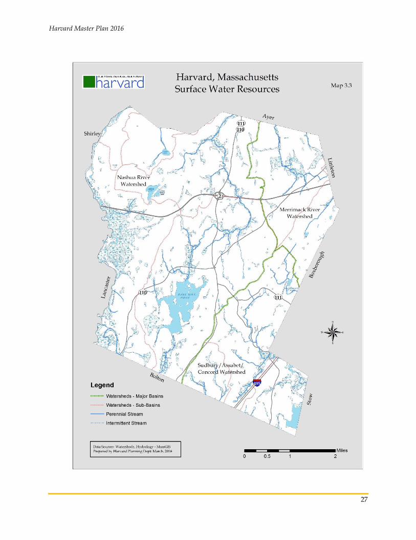
2. WATER RESOURCES
The long ridgelines on the east side of Harvard are indicative of major watershed divides. In fact, Harvard is located within three watersheds: the Nashua River watershed, which encompasses about two-thirds of the Town, and the Merrimack and Concord River watersheds, which separate roughly along Oak Hill and drain the east side of town. Harvard clearly shares groundwater and surface water with Devens and nearby towns, and historically Harvard’s large lot zoning has helped to protect the water quality of these water sources. Only one part of town has a Town-operated public water system (the Town Center), so it is difficult to track or report water quality characteristics for most of Harvard.
Surface Waters
Surface waters in Harvard include rivers, streams, ponds, and wetlands. Precipitation falling on the ground either infiltrates the ground and enters the groundwater system, sometimes discharging to surface water, or it flows on the surface to a surface water. The demarcation of which surface water resource this runoff enters is the watershed. Each watershed contains sub-basins (ten in total), and for any particular pond or wetland, there is a smaller watershed that only feeds that particular surface water resource. Map 3.3 shows the boundaries of the major basins and sub-basins in Harvard, along with the rivers, streams, ponds, and major wetlands. Not all wetlands appear on the map, however, and for those that do, the boundaries are approximate.
The Nashua River, a state-designated Scenic River, defines Harvard’s western boundary. It flows northward from Clinton to Nashua, N.H., where it joins the Merrimack River. Harvard’s most significant stream is Bowers Brook, a Class B surface water that flows from south to north in Harvard, running through a large swamp on the south side of town into the southern tip of Bare Hill Pond. Leaving the Pond, Bowers Brook flows northward, intermittently crossing swampy terrain, and ultimately merges with Cold Spring Brook in North Harvard. Other significant water courses include Elizabeth Brook, which drains the southeast corner of town (Concord watershed) and Bennetts Brook, which drains the northeast end of town (Merrimac watershed).
Bare Hill Pond: Bare Hill Pond is the largest and most prominent water body in Harvard. Arguably Harvard’s most significant natural resource, Bare Hill Pond has had a history typical for Massachusetts ponds that became prime real estate first for summer camps and later for year-round residences. A state-designated Great Pond, Bare Hill Pond covers approximately 300 acres. While much of the Pond’s shoreline remains wooded, most of it appears to be developed. Development around Bare Hill Pond began in 1887 with the construction of a camp on Sheep’s Island, followed a few years later by four more. Turner’s Lane was built in the 1910s, Wilroy Avenue and Clinton Shores were developed in the 1930s, and Willard Shores, Peninsula Road, and several homes on Warren Avenue were developed in the 1950s.15 More recent development has occurred mainly along the eastern and southern shores of the Pond. The rate of development accelerated from 1.1 units per year prior to 1931 to 1.7 units per year between 1931 and 1960, but has slowed considerably since then – now to less than one unit per year.
15 Development based on Assessor data, analyzed by RKG Associates, September 2014.
Harvard Master Plan 2016
27
Map 3.3 Surface Water Resources

Harvard Master Plan 2016
28
Shoreline development has contributed significantly to water quality problems at Bare Hill Pond, which numerous water quality studies have documented.16 The first dam was constructed in the early 1800s and rebuilt to increase the level of the Pond in 1837.17 Weed problems had become acute by the mid-1950s, when approximately 100 camps or homes existed. The first of three committees was formed to address these problems in 1959.18 Since 1987, the Bare Hill Pond Watershed Management Committee has overseen activities within the watershed of the Pond, not just the Pond itself. A new pumping system with capacity for deep drawdowns was installed in 2006 and it has resulted in a more successful weed control program.19 In 2010, after extensive study and design, a stormwater management system was constructed to better handle the stormwater runoff entering the Pond from the Town Center, the school and library parking lots, and Pond Road. As a result of this and the deep drawdowns that have taken place, the phosphorus levels which had placed Bare Hill Pond on the state’s endangered lakes list in the 1990s have fallen dramatically.20
As can be seen in Map 3.4, there are numerous undeveloped parcels within the watershed of Bare
Hill Pond. . . The Town itself owns a significant portion of the undeveloped land. If the Town’s
intention is to preserve its lands in perpetuity, and it has not already been done, then the Town Meeting should vote restrictions into place either through conservation restrictions or other deed
restrictions. In addition to continuing with drawdowns and maintenance of the stormwater system at the Pond Road area, public education directed at the property owners within the Pond’s watershed should help to maintain the phosphorus levels and other pollutants close to today’s
levels, even with a potential of additional housing development in the area. The developments
on the western shore of the Pond should be encouraged to examine the stormwater runoff on their properties, with an eye toward constructing systems similar to the Pond Road system in the
event that existing conditions continually contribute to problems within the Pond.
Other Water Bodies: The 103-acre main pond in the Delaney Wildlife Management Area in Harvard and Stow was created for flood control purposes, and it is the second largest water body in Harvard.21 Three smaller ponds lie within Devens: Mirror Lake, Little Mirror Lake, and Robbins Pond. There are half a dozen or so smaller ponds around town, most of which are part of larger wetland systems. Old Mill Pond, which has historic importance in Harvard, is threatened by sedimentation due to upstream development and erosion.
16 BHPWMC, http://www.harvard.ma.us/Pages/HarvardMA_BComm/BareHill/index, August 2014.
17 H.G. Marsh, Bare Hill Pond Chronology of Activities, September 15, 2002.
18 Ibid.
19 Ibid.
20 BHPWMC annual report, Harvard Annual Report for the Year 2013, http://www.harvard.ma.us/Pages/HarvardMA_BComm/ BOS/town, downloaded August 2014.
21 Harvard Conservation Trust, Trail map of Delaney WMA, http://harvardconservationtrust.org/trails.htm (accessed August 2014)

Harvard Master Plan 2016
29
Map 3.4 Bare Hill Pond Watershed

Harvard Master Plan 2016
30
Groundwater
For drinking water, the primary areas of importance are high and medium yield aquifers (areas with potentially adequate capacity for a public water supply) and the areas surrounding and recharging public water systems. The Massachusetts Department of Environmental Protection (DEP) regulates land around public water supplies where activity could have an impact on drinking water quality and quantity. These areas are known as Zone I, Zone II, and Interim Wellhead Protection Areas (IWPA). Zone I is a radius around a public water supply (usually 400 feet), and as a matter of DEP policy, public water suppliers are supposed to own or otherwise control the land. (This is not always the case with older wells, however.) Zone II, a larger area that almost always includes all of Zone I, is determined from field tests. From a regulatory perspective, Zone II is particularly important because it contains privately owned land that is either developed or could be developed in the future. The boundaries of a Zone II are determined from field tests while the IWPA is based on a formula (a radius of 400 feet or one-half mile, depending on the amount of water the well can produce). Harvard should delineate the Zone II of its municipal wells that serve the Town Center.
Land uses and development within Zone IIs and IWPAs are intended to be limited in order to protect the quality and rate of water recharging the well. In Massachusetts, each city and town is responsible for adopting and implementing protective zoning for water supplies. Harvard does not have these controls, perhaps because most of the Town is served by private wells. Furthermore, most of Harvard is underlain by glacial till soils and shallow depth to bedrock, conditions not suitable for public drinking water supplies. This is not the case at Devens, however, where the public water supplies tap a network of moderate- and high-yield aquifers. Nevertheless, as shown in Map 3.5, Harvard has numerous IWPAs for so-called community water supplies (private wells serving larger properties). Together with portions of IWPAs extending into Harvard from neighboring towns, Harvard has a total of 1,007 acres of land within IWPAs. In addition, two non-local Zone IIs extend into Harvard, including 51 acres within the Zone II of a water supply in Littleton and 554 acres in the Zone II of wells in Ayer. Also, Zone IIs for the wells at Devens are within Harvard’s boundaries, and there are vast aquifers under Devens, the Oxbow National Wildlife Refuge, and the Delaney Wildlife Management Area (1,497 acres). Despite the prevalence of land contributing rainfall to public water supplies, Harvard does not have any land use controls to help safeguard them from contamination. Harvard should consider adopting a ground water protection district to preserve the water quality of these aquifers.
3. AREAS OF ECOLOGICAL SIGNIFICANCE
Harvard has 5,726 acres of land in areas with known ecological significance. They include Areas of Critical Environmental Concern (ACEC), Core and Critical Habitat from the BioMap2, and Priority Habitats of Rare Species. Not surprisingly, most of these areas overlap. (See Map 3.6) Over half (3,300 acres) are along the Nashua River and within the Oxbow National Wildlife Refuge, extending into Devens and incorporating the Mirror Lakes and Robbins Pond (1,126 acres lie within the Devens boundary). A second significant environmentally sensitive area includes 1,488 acres on the eastern side of town, extending from Black Pond to Horse Meadow Pond.

Harvard Master Plan 2016
31
Map 3.5 Ground Water Resources

Harvard Master Plan 2016
32
The Massachusetts Natural Heritage & Endangered Species Program (NHESP) and The Nature Conservancy’s (TNC) Massachusetts Program developed BioMap2 in 2010 as a conservation plan to protect the state’s biodiversity.22 Areas identified as Core Habitat, encompassing 4,882 acres in Harvard, are necessary to promote the long-term survival of Species of Special Concern (those listed under the Massachusetts Endangered Species Act and additional species identified in the State Wildlife Action Plan), exemplary natural communities, and intact ecosystems. BioMap2 also includes areas known as Critical Natural Landscape, or intact landscapes that support ecological processes and support a wide range of species and habitats over the long term. Pastures and power-line rights-of-way are included, too, since they provide habitat and connectivity for many species. Harvard has 2,843 acres of such landscapes (partially overlapping Core Habitat). In addition, 3,972 acres in Harvard are classified as Priority Habitats of Rare Species (also overlapping), or areas within which state-listed rare species have been observed within the last twenty-five years.23 Mapped Priority Habitats determine whether a proposed project must be reviewed by the NHESP for compliance with the Massachusetts Endangered Species Act.24
Area of Critical Environmental Concern (ACEC)
Areas of Critical Environmental Concern (ACEC) have been designated by the Massachusetts Secretary of Energy and Environmental Affairs (EEA) as places that receive special recognition because of the quality, uniqueness, and significance of their natural and cultural resources.25 They are identified and nominated at the community level and reviewed by EEA staff. ACEC designation creates a framework for local and regional stewardship of critical resource areas and ecosystems. Due to efforts by officials in Harvard, Bolton, Lancaster, and Leominster, 12,884 acres of the Central Nashua River watershed won designation as an ACEC in 1996, including 2,109 acres in Harvard. The Central Nashua River Valley ACEC includes considerable open space – approximately 61 percent of the entire area – and much of it is protected: the Oxbow National Wildlife Refuge, Bolton Flats Wildlife Management Area, and over 1,000 acres of public and private conservation and recreation lands. According to state data, the total amount of open space within the ACEC is approximately 7,900 acres.26
22 NHESP, BioMap2 (2010), MassGIS. Harvard statistics compiled by RKG Associates Inc. August 28, 2014
23 NHESP, Priority Habitats of Rare Species (2008), MassGIS. Harvard statistics by RKG Associates Inc., August 28, 2014.
24 Massachusetts Natural Heritage Atlas, 13th ed. (October 2008).
25 MassGIS website, http://www.mass.gov/anf/research-and-tech/it-serv-and-support/application-serv/office-of-geographic-information-massgis/datalayers/acecs.html (downloaded 8/2014); Harvard statistics by RKG Associates Inc. 8/24/2014
26 Massachusetts Department of Energy and Environmental Affairs, “Central Nashua River Valley Resource Summary,” and “Designation of the Central Nashua River Valley Area of Critical Environmental Concern,” January 29, 1996.

Harvard Master Plan 2016
33
Map 3.6 Environmentally Sensitive Areas

Harvard Master Plan 2016
34
Floodplain
There is a strong correlation between environmentally sensitive areas and areas prone to flooding. Floodplains support wildlife habitat, aquifer recharge, flood storage, and water purification, and they are critical to the health of streams, ponds, and bordering vegetated wetlands. Map 3.7 shows the flood zones delineated by the National Flood Insurance Program (NFIP) in Harvard, and they are the basis for floodplain management and mitigation. There are four categories of flood prone areas: the floodway, two categories where there is a one percent chance of flooding in any given year, and the area adjacent to that where there is a lower chance of flooding. These areas perform different functions in a major storm event and they are subject to different degrees of regulatory protection. The floodway is the zone where the majority of water flows during a flood event, including the river or stream channel and the lowest lying areas along the banks. The two categories with a 1 percent annual chance of flooding (formerly known as the “100 year” floodplain) are differentiated by the presence or absence of base flood elevation data. Those areas with such data can be delineated more precisely. The fourth category, formerly known as the “500 year” floodplain, has a 0.2 percent chance of flooding in any given year.
Most flood prone areas in Harvard lie along the Nashua River and associated wetlands systems, Bowers Brook including Bare Hill Pond, Cold Spring Brook, Bennetts Brook, and Elizabeth Brook into the flood control ponds in the Delaney Wildlife Management Area. In all, there are 2,796 acres of flood prone areas in Harvard: 784 acres within the floodway, 1,249 acres of areas with a one percent annual chance of flooding (including 613 acres in ponds), and 763 acres of areas with a 0.2 percent annual chance of flooding. Harvard’s Zoning Bylaw includes provisions to minimize adverse impacts due to flooding. The Town complies with the National Flood Insurance Program, which qualifies property owners within flood plains for federal flood insurance.

Harvard Master Plan 2016
35
Map 3.7 Flood Prone Areas

Harvard Master Plan 2016
36
4. OPEN SPACE
Protected Open Space
Over 25 percent of the Town (excluding Devens) is protected in some way for conservation purposes. According to an open space inventory maintained by the Town, the Town and Land Trusts own and manage approximately 1,900 acres,27 state and federal agencies control about 1,350 acres, and land with an APR or CR total over 500 acres. The inventory of protected land includes some fairly large properties, such as the Great Elms (69 acres), Prospect Hill (61 acres), and the Bare Hill Wildlife Sanctuary on Bolton Road and the Clapp Land on Still River Road (44 acres each).
Harvard has historically been recognized as a leader in open space protection. Acquisitions, gifts, tax title takings, land swaps and other means of securing conservation land have been pursued in Harvard since at least 1962. Half a century of land preservation efforts have resulted in 4,245 acres of land in some form of permanent protection from development, or one quarter of Harvard’s total area.28 Since the 2002 Master Plan, Harvard has added over 700 acres of land in permanent protection. According to data provided by MassGIS, the protected open space in Harvard includes the following:
1,770 acres owned by the Town and 300 acres of Bare Hill Pond, a state-designated Great Pond;
866 acres within the Oxbow National Wildlife Refuge, owned by U.S. Fish & Wildlife Service;
483 acres owned by the Commonwealth of Massachusetts;
221 acres owned by the Harvard Conservation Trust and New England Forestry Foundation;
216 acres owned by various entities and protected with agricultural preservation restrictions (APR); and
306 acres owned by various entities and protected with conservation restrictions (CR).
As shown in Map 3.8, these are widespread across Harvard (including Devens) and largely disconnected. Individual parcels range in size from under one acre to over seventy acres.
Efforts to protect open space in Harvard have been and continue to be led by the Conservation Commission and the Harvard Conservation Trust (HCT). Incorporated in 1973, HCT has worked closely with the Conservation Commission and other groups to protect land and preserve Harvard’s rural character. As an independent entity, HCT can respond quickly to land acquisition and disposition opportunities. HCT holds Conservation Restrictions or Agricultural Preservation Restrictions (APR) on approximately 250 acres in Harvard.
27 Liz Allard, Land Use Administrator/Conservation Agent, and Open Space and Recreation Plan (2008).
28 Liz Allard, Land Use Administrator/Conservation Agent, and Open Space and Recreation Plan (2008).

Harvard Master Plan 2016
37
Map 3.8 Protected Open Space

Harvard Master Plan 2016
38
Unprotected Open Space
Some of Harvard’s most striking open space features are completely unprotected. This means they could be sold and developed at any time, although in nearly all cases the unrestricted open space in Harvard seems at very low risk for change.
Land temporarily protected under the Chapter 61 program reduces property tax obligations for owners of land in forestry use. According to Harvard’s most recent Open Space and Recreation Plan, there are 1,032 acres under Chapter 61 agreements with the Town. When the owners of Chapter 61 land decide to sell their property to a developer or change the use of their land to non-forestry purposes, the Town has a right of first refusal to purchase the property and protect it as open space.
Land temporarily protected under the Chapter 61A program reduces property tax obligations for owners of land in active agricultural use. Harvard currently has about 1,515 acres of Chapter 61A land. The same right of first refusal applies to the sale of Chapter 61A properties.
Land temporary protected under the Chapter 61B program helps to protect land in recreational use by reducing the owner’s property tax obligations.
Large institutional holdings include 133 acres owned by the Fruitlands Museum, 40 acres owned by the Sisters of Saint Benedict Center in Still River Village, 67 acres owned by the Saint Benedict Priory in Still River Village. Harvard University’s 37-acre Oak Hill Observatory, and 52 acres of camp properties around Bare Hill Pond.
Town-owned land amounts to approximately 230 acres, including land used for Town and school facilities and park and recreation areas.
Devens’ Open Space
The 1994 Devens Reuse Plan called for a substantial open space component, comprised of active
recreational areas, passive recreational areas, and conservation areas. The mixture of open space
types and ownership that resulted is rather similar to the mixture that exists within Residential
Harvard; thus, resuming jurisdiction is expected to essentially result in an extension of a natural
resource and open space mosaic that Harvard is accustomed to, complementing Harvard’s overall
open space acreage and diversity. Regardless of the disposition outcome, many natural resources,
such as the Nashua River, have regional importance from both protection/conservation and
stewardship perspectives and should be appropriately addressed in the Town of Harvard’s various
land use documents.
Assuming jurisdiction would afford a combined Harvard and Devens greater say over the
protection of viewsheds and natural resources within the Town’s boundaries, furthering the goals
of preserving Harvard’s “defining landscapes” and resources. Devens’ position on the landscape,
directly west of Residential Harvard and at a lower elevation, places it within the viewshed of
much of Residential Harvard, including Fruitlands and Prospect Hill. Likewise, natural resources
such as aquifers and wetland/stream systems (including the Nashua River) cross the Harvard-
Devens border, and their integrity can be affected by land use activities on either side of this line.

Harvard Master Plan 2016
39
While the Town might not have exclusive say over viewshed and natural resource issues in all
cases (for example, federal and state jurisdiction could still supersede local rule), assuming
jurisdiction of Devens would provide increased regulatory oversight by Harvard’s land use
boards including the Planning Board and Conservation Commission. Having greater say in these
cases would provide Harvard with greater assurance that development and conservation will
proceed in line with the Town’s stated goals. However, such oversight would result in a greater
workload than is currently experienced in Harvard and may require additional resources.