chapter 3.06 vegetation and terrestrial wildlife · 2016-10-03 · 3.6 vegetation and terrestrial...
TRANSCRIPT
Chapter 3.6 | Vegetation and Terrestrial Wildlife Page 3.6-1
3.6 VEGETATION AND TERRESTRIAL WILDLIFE
Natural vegetation provides habitat for wildlife, aesthetic amenities for people, and soil
stabilization. Vegetation may also hold cultural value and helps provide a buffer between
competing land uses. Wildlife species rely on vegetation and habitat resources for survival and
to assist in migration. They also bring commercial, recreational, and tribal assets to the
community by providing resources for hunters and fishermen as well as birders or nature
enthusiasts. Padilla Bay is an important wildlife habitat resource for the Pacific Flyway and it
supports an enormous variety of migratory wildlife.
STUDY AREA AND METHODOLOGY
The study area used to conduct an analysis of potential impacts to vegetation and terrestrial
wildlife was defined to include:
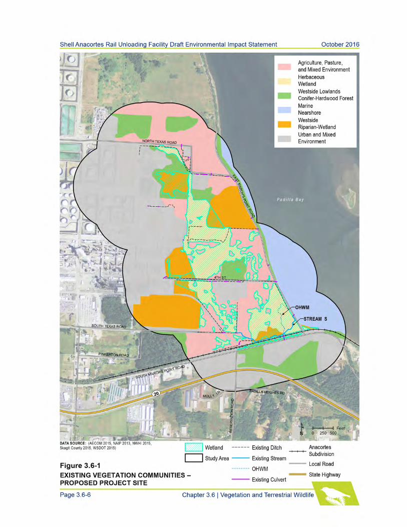
The proposed project site and lands within 1,045 feet (Figure 3.6-1). This area was used in
the biological evaluation prepared for the proposed project and accounts for the greatest
distance that atmospheric noise anticipated to be produced by construction and operation of
the proposed project could affect terrestrial species (AECOM 2016a).
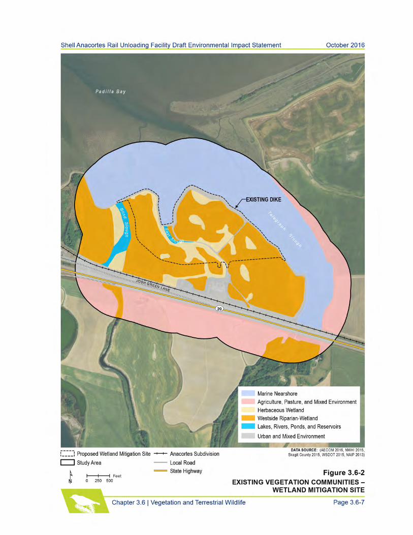
The proposed wetland mitigation site and lands within 1,045 feet (Figure 3.6-2) to account
for the greatest distance that atmospheric noise anticipated to be produced by construction
of the mitigation site could affect terrestrial species.
The Anacortes Subdivision and lands within 0.25 mile of the rail line (Figure 3.6-3 and
3.6-4). This area accounts for the limits of potential noise impacts resulting from operation
of the proposed project compared with existing conditions (see Chapter 3.9 – Noise and
Vibration).
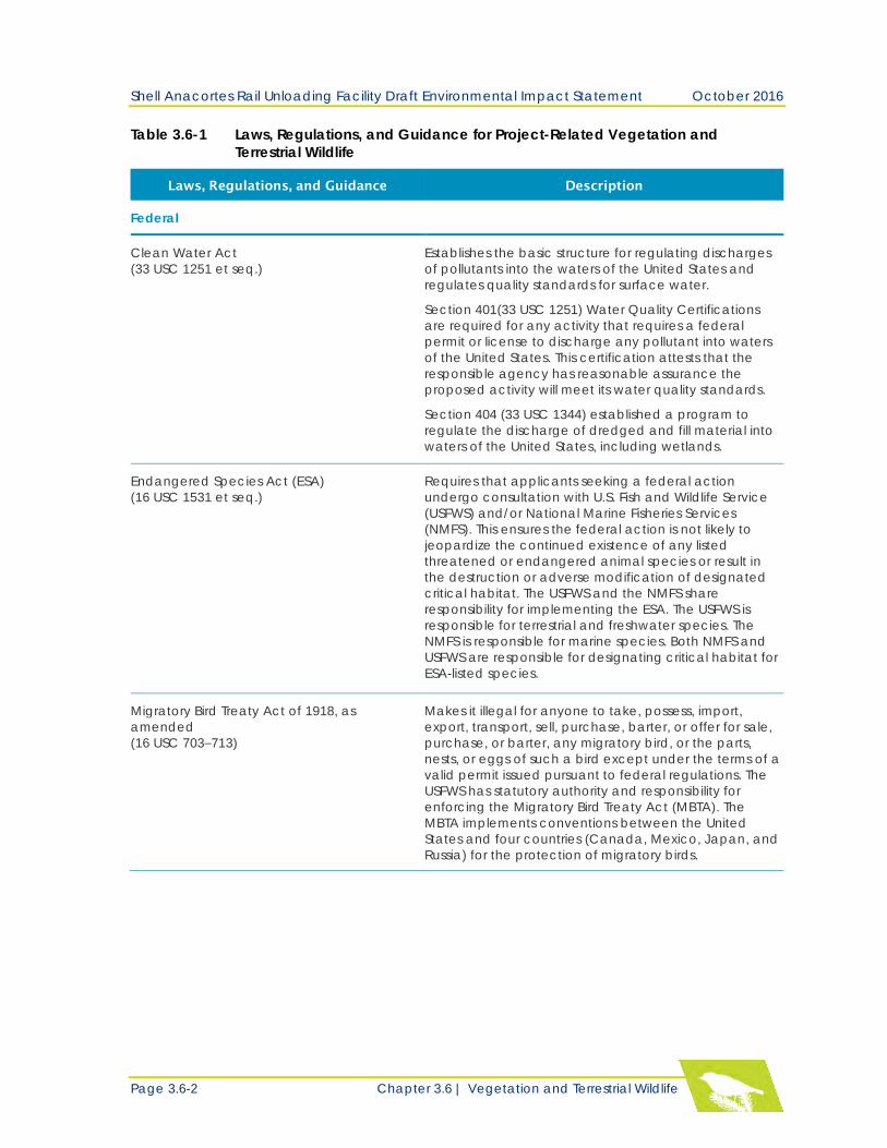
Select laws, regulations, and guidance applicable to vegetation and terrestrial wildlife associated
with the proposed project are summarized in Table 3.6-1.
Because the potential impacts associated with vegetation and terrestrial wildlife are localized, the
cumulative impacts study area would be the same as that described above for direct and indirect
impacts.
Shell Anacortes Rail Unloading Facility Draft Environmental Impact Statement October 2016
Page 3.6-2 Chapter 3.6 | Vegetation and Terrestrial Wildlife
Table 3.6-1 Laws, Regulations, and Guidance for Project-Related Vegetation and
Terrestrial Wildlife
Laws, Regulations, and Guidance Description
Federal
Clean Water Act
(33 USC 1251 et seq.)
Establishes the basic structure for regulating discharges
of pollutants into the waters of the United States and
regulates quality standards for surface water.
Section 401(33 USC 1251) Water Quality Certifications
are required for any activity that requires a federal
permit or license to discharge any pollutant into waters
of the United States. This certification attests that the
responsible agency has reasonable assurance the
proposed activity will meet its water quality standards.
Section 404 (33 USC 1344) established a program to
regulate the discharge of dredged and fill material into
waters of the United States, including wetlands.
Endangered Species Act (ESA)
(16 USC 1531 et seq.)
Requires that applicants seeking a federal action
undergo consultation with U.S. Fish and Wildlife Service
(USFWS) and/or National Marine Fisheries Services
(NMFS). This ensures the federal action is not likely to
jeopardize the continued existence of any listed
threatened or endangered animal species or result in
the destruction or adverse modification of designated
critical habitat. The USFWS and the NMFS share
responsibility for implementing the ESA. The USFWS is
responsible for terrestrial and freshwater species. The
NMFS is responsible for marine species. Both NMFS and
USFWS are responsible for designating critical habitat for
ESA-listed species.
Migratory Bird Treaty Act of 1918, as
amended
(16 USC 703–713)
Makes it illegal for anyone to take, possess, import,
export, transport, sell, purchase, barter, or offer for sale,
purchase, or barter, any migratory bird, or the parts,
nests, or eggs of such a bird except under the terms of a
valid permit issued pursuant to federal regulations. The
USFWS has statutory authority and responsibility for
enforcing the Migratory Bird Treaty Act (MBTA). The
MBTA implements conventions between the United
States and four countries (Canada, Mexico, Japan, and
Russia) for the protection of migratory birds.
Shell Anacortes Rail Unloading Facility Draft Environmental Impact Statement October 2016
Chapter 3.6 | Vegetation and Terrestrial Wildlife Page 3.6-3
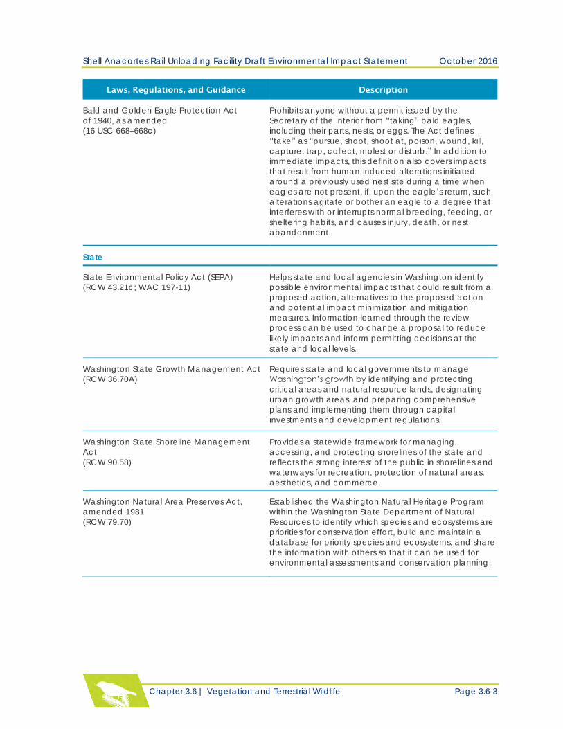
Laws, Regulations, and Guidance Description
Bald and Golden Eagle Protection Act
of 1940, as amended
(16 USC 668–668c)
Prohibits anyone without a permit issued by the
Secretary of the Interior from “taking” bald eagles,
including their parts, nests, or eggs. The Act defines
“take” as “pursue, shoot, shoot at, poison, wound, kill,
capture, trap, collect, molest or disturb.” In addition to
immediate impacts, this definition also covers impacts
that result from human-induced alterations initiated
around a previously used nest site during a time when
eagles are not present, if, upon the eagle’s return, such
alterations agitate or bother an eagle to a degree that
interferes with or interrupts normal breeding, feeding, or
sheltering habits, and causes injury, death, or nest
abandonment.
State
State Environmental Policy Act (SEPA)
(RCW 43.21c; WAC 197-11)
Helps state and local agencies in Washington identify
possible environmental impacts that could result from a
proposed action, alternatives to the proposed action
and potential impact minimization and mitigation
measures. Information learned through the review
process can be used to change a proposal to reduce
likely impacts and inform permitting decisions at the
state and local levels.
Washington State Growth Management Act
(RCW 36.70A)
Requires state and local governments to manage
Washington’s growth by identifying and protecting
critical areas and natural resource lands, designating
urban growth areas, and preparing comprehensive
plans and implementing them through capital
investments and development regulations.
Washington State Shoreline Management
Act
(RCW 90.58)
Provides a statewide framework for managing,
accessing, and protecting shorelines of the state and
reflects the strong interest of the public in shorelines and
waterways for recreation, protection of natural areas,
aesthetics, and commerce.
Washington Natural Area Preserves Act,
amended 1981
(RCW 79.70)
Established the Washington Natural Heritage Program
within the Washington State Department of Natural
Resources to identify which species and ecosystems are
priorities for conservation effort, build and maintain a
database for priority species and ecosystems, and share
the information with others so that it can be used for
environmental assessments and conservation planning.
Shell Anacortes Rail Unloading Facility Draft Environmental Impact Statement October 2016
Page 3.6-4 Chapter 3.6 | Vegetation and Terrestrial Wildlife
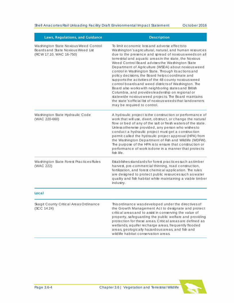
Laws, Regulations, and Guidance Description
Washington State Noxious Weed Control
Boards and State Noxious Weed List
(RCW 17.10, WAC 16-750)
To limit economic loss and adverse effects to
Washington’s agricultural, natural, and human resources
due to the presence and spread of noxious weeds on all
terrestrial and aquatic areas in the state, the Noxious
Weed Control Board advises the Washington State
Department of Agriculture (WSDA) about noxious weed
control in Washington State. Through its actions and
policy decisions, the Board helps coordinate and
supports the activities of the 48 county noxious weed
control boards and weed districts of Washington. The
Board also works with neighboring states and British
Columbia, and provides leadership on regional or
statewide noxious weed projects. The Board maintains
the state’s official list of noxious weeds that landowners
may be required to control.
Washington State Hydraulic Code
(WAC 220-660)
A hydraulic project is the construction or performance of
work that will use, divert, obstruct, or change the natural
flow or bed of any of the salt or fresh waters of the state.
Unless otherwise provided, any person who wishes to
conduct a hydraulic project must get a construction
permit called the hydraulic project approval (HPA) from
the Washington Department of Fish and Wildlife (WDFW).
The purpose of the HPA is to ensure that construction or
performance of work is done in a manner that protects
fish life.
Washington State Forest Practices Rules
(WAC 222)
Establishes standards for forest practices such as timber
harvest, pre-commercial thinning, road construction,
fertilization, and forest chemical application. The rules
are designed to protect public resources such as water
quality and fish habitat while maintaining a viable timber
industry.
Local
Skagit County Critical Areas Ordinance
(SCC 14.24)
This ordinance was developed under the directives of
the Growth Management Act to designate and protect
critical areas and to assist in conserving the value of
property, safeguarding the public welfare and providing
protection for these areas. Critical areas are defined as
wetlands, aquifer recharge areas, frequently flooded
areas, geologically hazardous areas, and fish and
wildlife habitat conservation areas.
Shell Anacortes Rail Unloading Facility Draft Environmental Impact Statement October 2016
Chapter 3.6 | Vegetation and Terrestrial Wildlife Page 3.6-5
Laws, Regulations, and Guidance Description
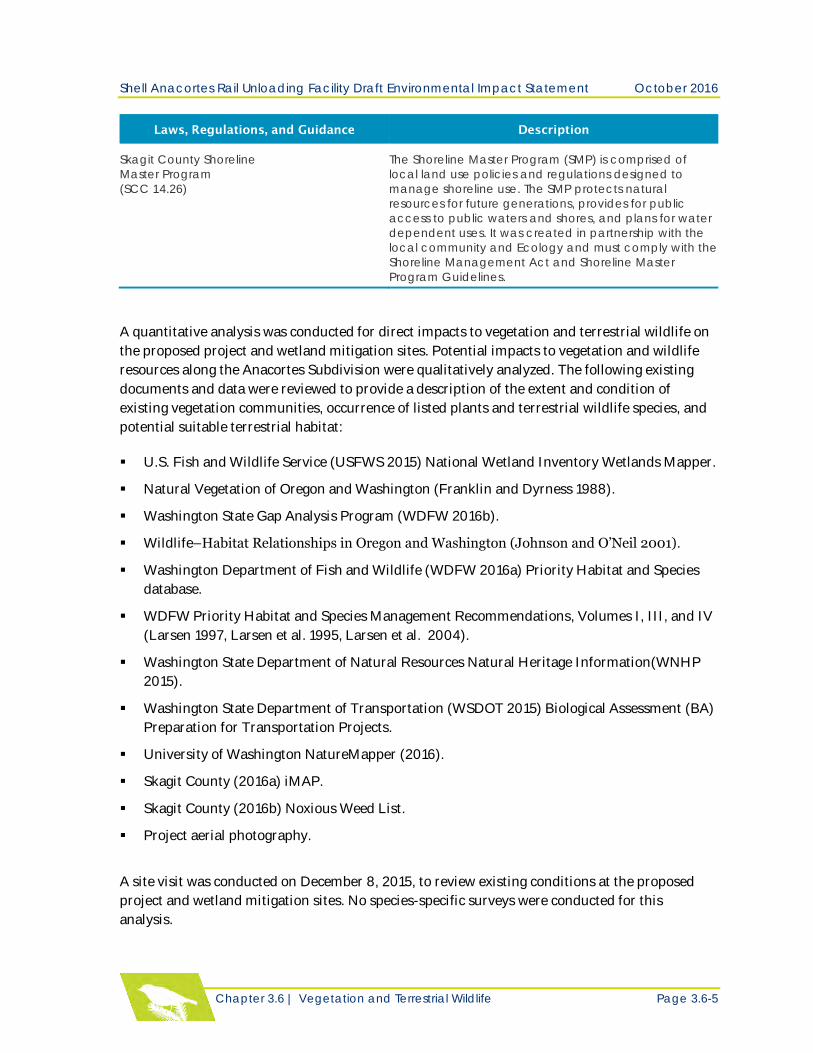
Skagit County Shoreline
Master Program
(SCC 14.26)
The Shoreline Master Program (SMP) is comprised of
local land use policies and regulations designed to
manage shoreline use. The SMP protects natural
resources for future generations, provides for public
access to public waters and shores, and plans for water
dependent uses. It was created in partnership with the
local community and Ecology and must comply with the
Shoreline Management Act and Shoreline Master
Program Guidelines.
A quantitative analysis was conducted for direct impacts to vegetation and terrestrial wildlife on
the proposed project and wetland mitigation sites. Potential impacts to vegetation and wildlife
resources along the Anacortes Subdivision were qualitatively analyzed. The following existing
documents and data were reviewed to provide a description of the extent and condition of
existing vegetation communities, occurrence of listed plants and terrestrial wildlife species, and
potential suitable terrestrial habitat:
U.S. Fish and Wildlife Service (USFWS 2015) National Wetland Inventory Wetlands Mapper.
Natural Vegetation of Oregon and Washington (Franklin and Dyrness 1988).
Washington State Gap Analysis Program (WDFW 2016b).
Wildlife–Habitat Relationships in Oregon and Washington (Johnson and O’Neil 2001).
Washington Department of Fish and Wildlife (WDFW 2016a) Priority Habitat and Species
database.
WDFW Priority Habitat and Species Management Recommendations, Volumes I, III, and IV
(Larsen 1997, Larsen et al. 1995, Larsen et al. 2004).
Washington State Department of Natural Resources Natural Heritage Information(WNHP
2015).
Washington State Department of Transportation (WSDOT 2015) Biological Assessment (BA)
Preparation for Transportation Projects.
University of Washington NatureMapper (2016).
Skagit County (2016a) iMAP.
Skagit County (2016b) Noxious Weed List.
Project aerial photography.
A site visit was conducted on December 8, 2015, to review existing conditions at the proposed
project and wetland mitigation sites. No species-specific surveys were conducted for this
analysis.
Shell Anacortes Rail Unloading Facility Draft Environmental Impact Statement October 2016
Page 3.6-8 Chapter 3.6 | Vegetation and Terrestrial Wildlife
Existing vegetation communities were mapped using a Geographic Information System (GIS)-
based land cover analysis of the study area, available literature and inventories, project-specific
studies, and observations from a site visit. Vegetation communities were categorized into land
cover types based on similarities in landscape features (for example, types of vegetation and level
of vegetation disturbance and management).
Terrestrial wildlife species and habitat were evaluated using the results of the vegetation
community analysis identified in Johnson and O’Neil (2001). Information provided by Shell
(URS 2013; AECOM 2016a and 2016b) and additional information from Washington
Department of Fish and Wildlife (WDFW), U.S. Fish and Wildlife Service (USFWS), and other
sources were incorporated into the analysis to determine potential habitat use by wildlife in the
study area.
Potential impacts of project construction and operation on vegetation and terrestrial wildlife
were evaluated relative to the no action alternative. Impacts can be either adverse or beneficial.
Direct impacts affect vegetation communities and wildlife habitat, special-status plants, and
terrestrial wildlife species occurrence and habitat, and can result from temporary and permanent
construction activities. Direct impacts were calculated using temporary and permanent
footprints overlaid on GIS data at both the proposed project and wetland mitigation sites. The
analysis also used the results from the noise study (see Chapter 3.9 – Noise and Vibration) to
evaluate potential noise impacts associated with construction and operations at the project site
on key wildlife species.
Indirect impacts were qualitatively analyzed at the proposed project and wetland mitigation
sites. The analysis considered such factors as the potential impacts of the train operations on
species and habitat, the regional significance of the resource, wildlife habitat value, degree of
fragmentation and loss of the habitat following project implementation, and impacts to overall
habitat quality. Temporary and long-term indirect impacts due to disturbances from increases in
human access, noise, and light were also assessed.
Criteria for determining the significance of impacts were developed by considering the context
and magnitude, duration, and degree of potential environmental impacts as specified in the State
Environmental Policy Act (SEPA). Washington Administrative Code (WAC 197-11-794) defines
“significant” as “a reasonable likelihood of more than a moderate adverse impact on
environmental quality.”
Significant negative impacts to vegetation are defined for this project as:
Loss of native vegetation that results in a substantial and permanent decrease in extent,
connectivity, or integrity of upland or vegetated wetland habitat in the contributing
watershed and that would impair the function of impacted vegetative communities.
Establishment of invasive plant species that results in a decrease in extent, connectivity, or
integrity of native vegetation communities.
Shell Anacortes Rail Unloading Facility Draft Environmental Impact Statement October 2016
Chapter 3.6 | Vegetation and Terrestrial Wildlife Page 3.6-9
Loss of sensitive plant communities or suitable habitat.
Significant negative impacts to terrestrial species and habitat from project-related construction,
operations, or human activity are defined as:
Loss of breeding habitat that would adversely affect the population viability of a species.
Loss of nonbreeding wildlife habitat that results in a significant decrease in extent,
connectivity, or integrity of habitat in the watershed.
Injury, death, or harassment of wildlife that would adversely affect the population viability of
a species.
Impact significance criteria for federally-listed threatened and endangered species were based
upon findings in the biological evaluation prepared for the proposed project (AECOM 2016a), the
WSDOT (2015) BA manual, and potential direct and indirect impacts of the proposed project
identified during the preparation of this environmental impact statement (EIS). The analysis also
identified any mitigation measures, commitments, and monitoring procedures associated with
project impacts on plants and terrestrial species and habitat.
AFFECTED ENVIRONMENT
Proposed Project and Wetland Mitigation Sites
The study area is located in the western hemlock forest vegetation zone of the Puget Lowland
physiographic province (Franklin and Dyrness 1988) and within the watersheds of Telegraph
Slough-Frontal Padilla Bay, Padilla Bay-Strait of Georgia, and Skagit River-Frontal Skagit Bay
(Hydrologic Unit Code 1711000203, 171100020303, and 171100010500). The wetland mitigation
site and Anacortes Subdivision are located in extensive floodplains associated with the post-
glacial Skagit River delta system. The Swinomish Channel is the main remnant distributary
channel in the study area. Telegraph Slough and several other remnant distributary channels are
also present but are mostly cut off from Padilla Bay by roads, levees, or dikes. The Shell Puget
Sound Refinery (PSR) site on March Point peninsula is located on a raised marine terrace at least
160 feet above the Skagit River floodplain (Bulthius 2013).
Native vegetation communities and wildlife habitat have been substantially altered and
fragmented since the early 19th century due to land clearing, dredging, and diking of tidelands for
agriculture and maritime navigation, and development of rail and road transportation systems.
Portions of the proposed project site on March Point were cleared for agricultural land use
starting in the mid-1800s (City of Anacortes 2016). The existing rail line in the southern portion
of the proposed project site (i.e., the Anacortes Subdivision) was originally built in 189o (Skagit
County 2015), and roads in the study area were built starting in the early 20th century. The March
Point peninsula was dominated by deciduous and coniferous forest prior to the development of
the Shell and Texaco (now Tesoro) refineries in the 1950s (Skagit County 2016a, Historylink
2016).
Shell Anacortes Rail Unloading Facility Draft Environmental Impact Statement October 2016
Page 3.6-10 Chapter 3.6 | Vegetation and Terrestrial Wildlife
The wetland mitigation site was a tidal marsh before it was diked and drained for agriculture in
the late 1800s. It was used for grain and vegetable crop production until it was converted to a
hybrid poplar tree farm in 1997 (AECOM 2016b).
The Anacortes Subdivision is located within the Skagit Valley, which was converted from a large
delta system with extensive sloughs, salt marshes, and mud flats to agricultural land starting in
the 19th century.
Vegetation
Table 3.6-2 summarizes the locations of existing vegetation communities and land cover types
identified within the study area following descriptions in Johnson and O’Neil (2001).
Table 3.6-2 Vegetation Communities and Land Cover Type Descriptions
Vegetation Community/Land Cover Type Description
Urban and mixed environs Man-made transportation corridors, buildings,
impermeable surfaces, bridges, dams, devoid of
native vegetation
Agricultural, pasture, and mixed environs Cultivated croplands, modified grasslands, and
mowed, hayed, or grazed pastures
Lowland conifer-hardwood forest Upland tree stands dominated by evergreen conifers
and/ or deciduous trees
Westside riparian-wetland Freshwater forested and scrub-shrub wetlands and
forested/shrub vegetation associated with rivers and
streams
Herbaceous wetlands Freshwater emergent wetlands
Lakes, rivers, ponds, and reservoirs Freshwater aquatic habitat; vegetation may occur at
the margins but features are mostly unvegetated
Bays and estuaries Lower reaches of rivers, estuarine wetlands, intertidal
sand and mud flats, estuarine wetlands
Marine nearshore Marine water areas along shorelines not significantly
affected by freshwater inputs with unvegetated or
submerged vegetated habitat
Shell Anacortes Rail Unloading Facility Draft Environmental Impact Statement October 2016
Chapter 3.6 | Vegetation and Terrestrial Wildlife Page 3.6-11
Proposed Project Site
Vegetation that currently occurs at the project site is
predominantly pasture that has been used for cattle
grazing, with remnant isolated patches of mixed
deciduous-coniferous, second-growth forests. The
west side of the project site is comprised of
developed industrial land associated with the
existing Shell PSR facilities. Estuarine habitat is
located in the southeast corner of the Shell PSR
property, and nearshore marine habitat in Padilla
Bay is found to the east of the project site.
Vegetation Communities
Table 3.6-3 summarizes vegetation communities and land cover type composition and
prevalence within the project site and surrounding study area. Please refer to Chapter 3.5 –
Wetlands, for a detailed description of freshwater wetlands within the project site, and
Chapter 3.4 – Fish and Aquatic Species and Habitat, for details on freshwater, tidal, and
nearshore aquatic habitat in the project vicinity.
Table 3.6-3 Vegetation Communities and Land Cover Type Prevalence – Project Site
Vegetation
Community/
Land Cover
Type
Occurrence in the Project Site
and Surrounding Study Area
and Dominant Vegetation1
Prevalence in
this Portion of
the Study Area
(approximate)
Urban and
mixed environs
This is the predominant cover type in this portion of the study
area and encompasses developed portions of the Shell PSR
site, Anacortes Subdivision, roads, and businesses south of the
proposed project site. Vegetation is sparse and consists of
introduced plant species near the edge of rail and road rights
of way and facility perimeters.
39%
(249 acres)
Agricultural,
pasture and
mixed environs
Undeveloped portions of the Shell PSR site mainly consist of
pasture that has been heavily grazed by cattle. Dominant
native and introduced plant species include velvetgrass
(Holcus lanatus), bentgrasses (Agrostis spp.), fescues (Festuca
spp.), crested dogtail (Cynosurus cristatus), Kentucky bluegrass
(Poa pratensis), meadow foxtail (Alopecurus pratensis), clovers
(Trifolium spp.), dandelion (Taraxacum officinale), birds-foot
trefoil (Lotus corniculatus), garden vetch (Vicia sativa), hairy
vetch (Vicia hirsuta), mouse-ear chickweed (Cerastium
glomeratum), wheatgrass (Agropyron sp.), Coastal wormwood
(Artemisia suksdorfii), Fuller’s teasel (Dipsacus fullonum), and
lesser hawkbit(Leontodon saxatilis). Noxious weeds found in the
pastures are discussed in the “Noxious Weeds” subsection in this
chapter.
18%
(112 acres)
Nootka rose
Shell Anacortes Rail Unloading Facility Draft Environmental Impact Statement October 2016
Page 3.6-12 Chapter 3.6 | Vegetation and Terrestrial Wildlife
Vegetation
Community/
Land Cover
Type
Occurrence in the Project Site
and Surrounding Study Area
and Dominant Vegetation1
Prevalence in
this Portion of
the Study Area
(approximate)
Herbaceous
wetlands
Emergent wetlands are the predominant wetland vegetation
community in this portion of the study area, and mainly occur
in grazed pastures. These wetlands are temporarily or
occasionally flooded to seasonally saturated. Plant species
composition is similar to agricultural/pasture vegetation
described above.
12%
(74 acres)
Westside
riparian-wetland
Forested and scrub-shrub wetlands occur in fragmented
patches throughout the proposed project site and surrounding
study area. These are depressional wetlands with seasonal
inundation and slope wetlands that are temporarily flooded or
seasonally saturated. Dominant tree species are red alder
(Alnus rubra), black cottonwood (Populus balsamifera) and
Pacific willow (Salix lasiandra); scattered quaking aspen
(Populus tremuloides) and western red cedar (Thuja plicata)
also occur. Common understory shrub and emergent species in
these wetlands include salmonberry (Rubus spectabilis), Nootka
rose (Rosa nutkana), Douglas spirea (Spiraea douglasii), black
twinberry (Lonicera involucrata), Sitka willow (Salix sitchensis),
lady fern (Athyrium filix-femina), and fringecup (Tellima
grandiflora).
One patch of riparian vegetation associated with Stream S
occurs in the southern portion of the Shell PSR site. Native
vegetation consists of black cottonwood and red alder,
Douglas spirea, Nootka rose, Sitka willow, and snowberry
(Symphoricarpos albus). However, it is a small, isolated
vegetation community with no connectivity to larger riparian
corridors. No other riparian vegetation occurs in this portion of
the study area.
11%
(73 acres)
Lowland conifer-
hardwood forest
Remnant patches of upland coniferous and deciduous forest are
found throughout the proposed project site and surrounding area.
Dominant tree species are red alder, black cottonwood, paper
birch (Betula papyrifera), western red cedar, Douglas fir
(Pseudotsuga menziesii), bigleaf maple (Acer macrophyllum),
quaking aspen, and grand fir (Abies grandis).
Common native and introduced understory shrubs include
salmonberry, trailing blackberry (Rubus ursinus), snowberry, Indian
plum (Oemleria cerasiformis), tall Oregon grape (Mahonia
aquifolium), red elderberry (Sambucus racemosa), Pacific
crabapple (Malus fusca), red huckleberry (Vaccinium parvifolium),
vine maple (Acer circinatum), oceanspray (Holodiscus discolor),
and coast black gooseberry (Ribes divaricatum).
Herbaceous species in the understory include sword fern
(Polystichum munitum), northern woodfern (Dryopteris expansa),
bracken fern (Pteridium aquilinum), stinging nettle
(Urticadioica), fringecup, Siberian miner’s lettuce (Claytonia
sibirica), common bedstraw (Galium aparine), and bittercress
(Cardamine sp.).
10%
(66 acres)
Shell Anacortes Rail Unloading Facility Draft Environmental Impact Statement October 2016
Chapter 3.6 | Vegetation and Terrestrial Wildlife Page 3.6-13
Vegetation
Community/
Land Cover
Type
Occurrence in the Project Site
and Surrounding Study Area
and Dominant Vegetation1
Prevalence in
this Portion of
the Study Area
(approximate)
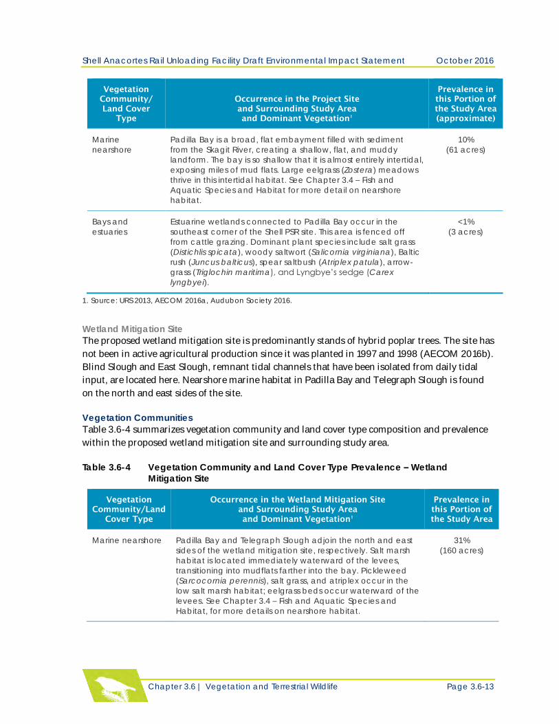
Marine
nearshore
Padilla Bay is a broad, flat embayment filled with sediment
from the Skagit River, creating a shallow, flat, and muddy
landform. The bay is so shallow that it is almost entirely intertidal,
exposing miles of mud flats. Large eelgrass (Zostera) meadows
thrive in this intertidal habitat. See Chapter 3.4 – Fish and
Aquatic Species and Habitat for more detail on nearshore
habitat.
10%
(61 acres)
Bays and
estuaries
Estuarine wetlands connected to Padilla Bay occur in the
southeast corner of the Shell PSR site. This area is fenced off
from cattle grazing. Dominant plant species include salt grass
(Distichlis spicata), woody saltwort (Salicornia virginiana), Baltic
rush (Juncus balticus), spear saltbush (Atriplex patula), arrow-
grass (Triglochin maritima), and Lyngbye’s sedge (Carex
lyngbyei).
<1%
(3 acres)
1. Source: URS 2013, AECOM 2016a, Audubon Society 2016.
Wetland Mitigation Site
The proposed wetland mitigation site is predominantly stands of hybrid poplar trees. The site has
not been in active agricultural production since it was planted in 1997 and 1998 (AECOM 2016b).
Blind Slough and East Slough, remnant tidal channels that have been isolated from daily tidal
input, are located here. Nearshore marine habitat in Padilla Bay and Telegraph Slough is found
on the north and east sides of the site.
Vegetation Communities
Table 3.6-4 summarizes vegetation community and land cover type composition and prevalence
within the proposed wetland mitigation site and surrounding study area.
Table 3.6-4 Vegetation Community and Land Cover Type Prevalence – Wetland
Mitigation Site
Vegetation
Community/Land
Cover Type
Occurrence in the Wetland Mitigation Site
and Surrounding Study Area
and Dominant Vegetation1
Prevalence in
this Portion of
the Study Area
Marine nearshore Padilla Bay and Telegraph Slough adjoin the north and east
sides of the wetland mitigation site, respectively. Salt marsh
habitat is located immediately waterward of the levees,
transitioning into mudflats farther into the bay. Pickleweed
(Sarcocornia perennis), salt grass, and atriplex occur in the
low salt marsh habitat; eelgrass beds occur waterward of the
levees. See Chapter 3.4 – Fish and Aquatic Species and
Habitat, for more details on nearshore habitat.
31%
(160 acres)
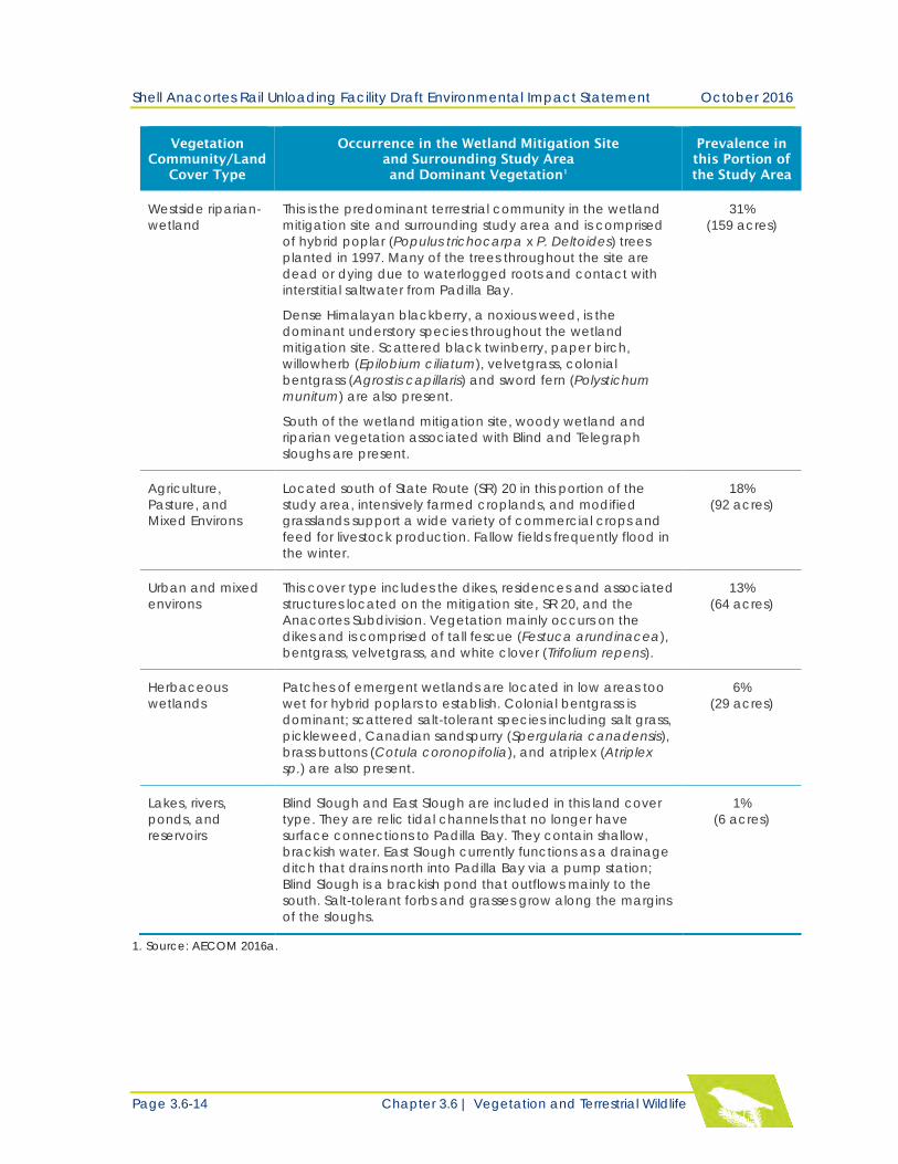
Shell Anacortes Rail Unloading Facility Draft Environmental Impact Statement October 2016
Page 3.6-14 Chapter 3.6 | Vegetation and Terrestrial Wildlife
Vegetation
Community/Land
Cover Type
Occurrence in the Wetland Mitigation Site
and Surrounding Study Area
and Dominant Vegetation1
Prevalence in
this Portion of
the Study Area
Westside riparian-
wetland
This is the predominant terrestrial community in the wetland
mitigation site and surrounding study area and is comprised
of hybrid poplar (Populus trichocarpa x P. Deltoides) trees
planted in 1997. Many of the trees throughout the site are
dead or dying due to waterlogged roots and contact with
interstitial saltwater from Padilla Bay.
Dense Himalayan blackberry, a noxious weed, is the
dominant understory species throughout the wetland
mitigation site. Scattered black twinberry, paper birch,
willowherb (Epilobium ciliatum), velvetgrass, colonial
bentgrass (Agrostis capillaris) and sword fern (Polystichum
munitum) are also present.
South of the wetland mitigation site, woody wetland and
riparian vegetation associated with Blind and Telegraph
sloughs are present.
31%
(159 acres)
Agriculture,
Pasture, and
Mixed Environs
Located south of State Route (SR) 20 in this portion of the
study area, intensively farmed croplands, and modified
grasslands support a wide variety of commercial crops and
feed for livestock production. Fallow fields frequently flood in
the winter.
18%
(92 acres)
Urban and mixed
environs
This cover type includes the dikes, residences and associated
structures located on the mitigation site, SR 20, and the
Anacortes Subdivision. Vegetation mainly occurs on the
dikes and is comprised of tall fescue (Festuca arundinacea),
bentgrass, velvetgrass, and white clover (Trifolium repens).
13%
(64 acres)
Herbaceous
wetlands
Patches of emergent wetlands are located in low areas too
wet for hybrid poplars to establish. Colonial bentgrass is
dominant; scattered salt-tolerant species including salt grass,
pickleweed, Canadian sandspurry (Spergularia canadensis),
brass buttons (Cotula coronopifolia), and atriplex (Atriplex
sp.) are also present.
6%
(29 acres)
Lakes, rivers,
ponds, and
reservoirs
Blind Slough and East Slough are included in this land cover
type. They are relic tidal channels that no longer have
surface connections to Padilla Bay. They contain shallow,
brackish water. East Slough currently functions as a drainage
ditch that drains north into Padilla Bay via a pump station;
Blind Slough is a brackish pond that outflows mainly to the
south. Salt-tolerant forbs and grasses grow along the margins
of the sloughs.
1%
(6 acres)
1. Source: AECOM 2016a.
Shell Anacortes Rail Unloading Facility Draft Environmental Impact Statement October 2016
Chapter 3.6 | Vegetation and Terrestrial Wildlife Page 3.6-15
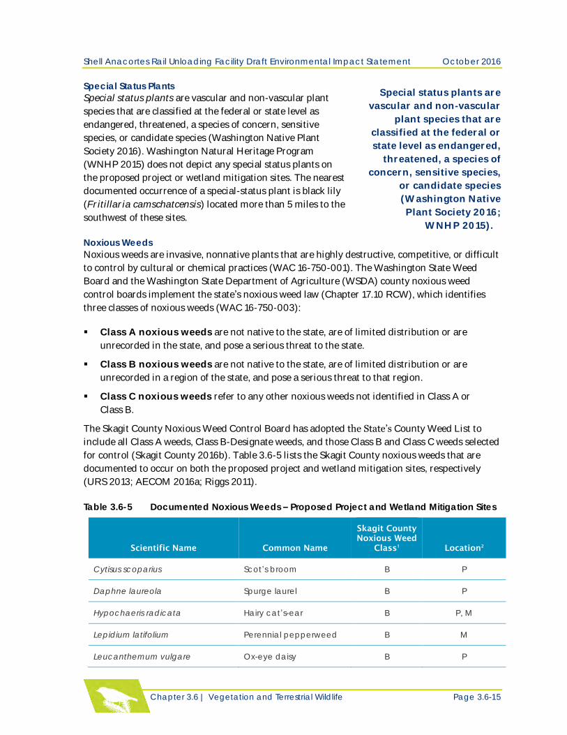
Special Status Plants
Special status plants are vascular and non-vascular plant
species that are classified at the federal or state level as
endangered, threatened, a species of concern, sensitive
species, or candidate species (Washington Native Plant
Society 2016). Washington Natural Heritage Program
(WNHP 2015) does not depict any special status plants on
the proposed project or wetland mitigation sites. The nearest
documented occurrence of a special-status plant is black lily
(Fritillaria camschatcensis) located more than 5 miles to the
southwest of these sites.
Noxious Weeds
Noxious weeds are invasive, nonnative plants that are highly destructive, competitive, or difficult
to control by cultural or chemical practices (WAC 16-750-001). The Washington State Weed
Board and the Washington State Department of Agriculture (WSDA) county noxious weed
control boards implement the state’s noxious weed law (Chapter 17.10 RCW), which identifies
three classes of noxious weeds (WAC 16-750-003):
Class A noxious weeds are not native to the state, are of limited distribution or are
unrecorded in the state, and pose a serious threat to the state.
Class B noxious weeds are not native to the state, are of limited distribution or are
unrecorded in a region of the state, and pose a serious threat to that region.
Class C noxious weeds refer to any other noxious weeds not identified in Class A or
Class B.
The Skagit County Noxious Weed Control Board has adopted the State’s County Weed List to
include all Class A weeds, Class B-Designate weeds, and those Class B and Class C weeds selected
for control (Skagit County 2016b). Table 3.6-5 lists the Skagit County noxious weeds that are
documented to occur on both the proposed project and wetland mitigation sites, respectively
(URS 2013; AECOM 2016a; Riggs 2011).
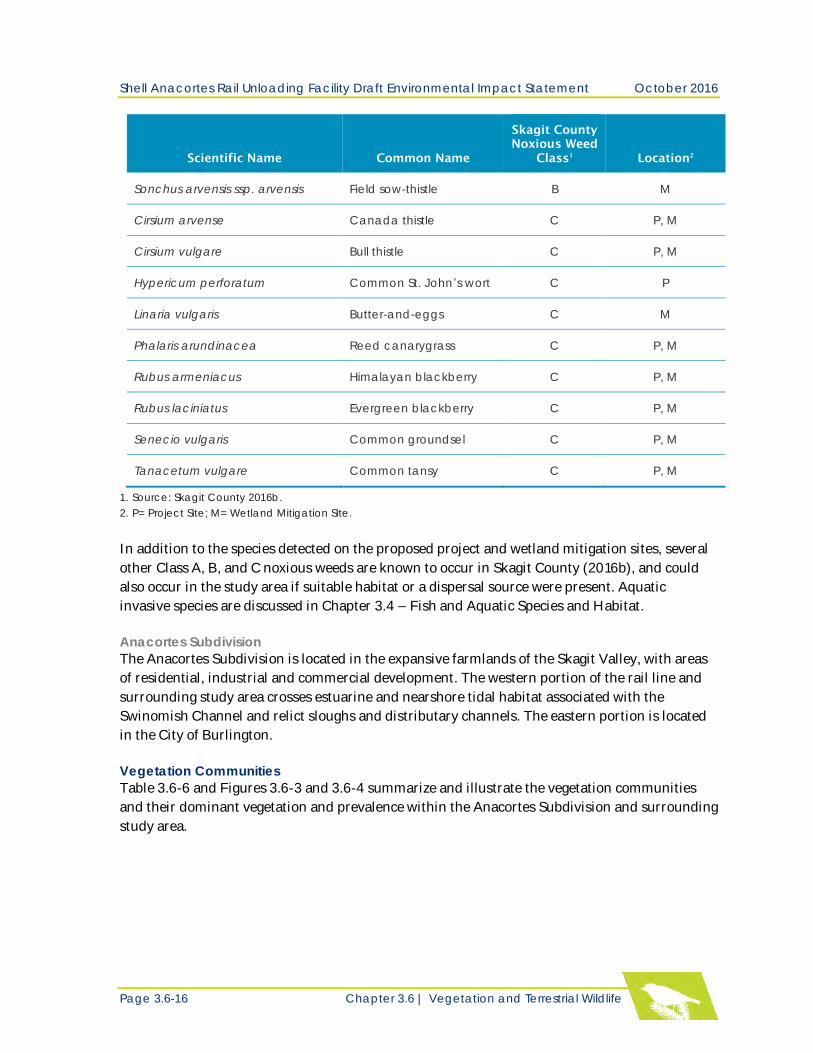
Table 3.6-5 Documented Noxious Weeds – Proposed Project and Wetland Mitigation Sites
Scientific Name Common Name
Skagit County
Noxious Weed
Class1
Location2
Cytisus scoparius Scot’s broom B P
Daphne laureola Spurge laurel B P
Hypochaeris radicata Hairy cat’s-ear B P, M
Lepidium latifolium Perennial pepperweed B M
Leucanthemum vulgare Ox-eye daisy B P
Pull quote:
Special status plants are
vascular and non-vascular
plant species that are
classified at the federal or
state level as endangered,
threatened, a species of
concern, sensitive species,
or candidate species
(Washington Native
Plant Society 2016;
WNHP 2015). Pull quote end.
Shell Anacortes Rail Unloading Facility Draft Environmental Impact Statement October 2016
Page 3.6-16 Chapter 3.6 | Vegetation and Terrestrial Wildlife
Scientific Name Common Name
Skagit County
Noxious Weed
Class1
Location2
Sonchus arvensis ssp. arvensis Field sow-thistle B M
Cirsium arvense Canada thistle C P, M
Cirsium vulgare Bull thistle C P, M
Hypericum perforatum Common St. John’s wort C P
Linaria vulgaris Butter-and-eggs C M
Phalaris arundinacea Reed canarygrass C P, M
Rubus armeniacus Himalayan blackberry C P, M
Rubus laciniatus Evergreen blackberry C P, M
Senecio vulgaris Common groundsel C P, M
Tanacetum vulgare Common tansy C P, M
1. Source: Skagit County 2016b.
2. P= Project Site; M= Wetland Mitigation Site.
In addition to the species detected on the proposed project and wetland mitigation sites, several
other Class A, B, and C noxious weeds are known to occur in Skagit County (2016b), and could
also occur in the study area if suitable habitat or a dispersal source were present. Aquatic
invasive species are discussed in Chapter 3.4 – Fish and Aquatic Species and Habitat.
Anacortes Subdivision
The Anacortes Subdivision is located in the expansive farmlands of the Skagit Valley, with areas
of residential, industrial and commercial development. The western portion of the rail line and
surrounding study area crosses estuarine and nearshore tidal habitat associated with the
Swinomish Channel and relict sloughs and distributary channels. The eastern portion is located
in the City of Burlington.
Vegetation Communities
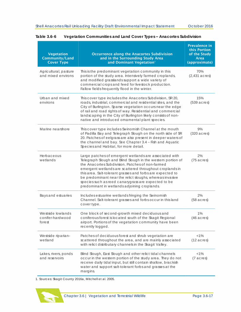
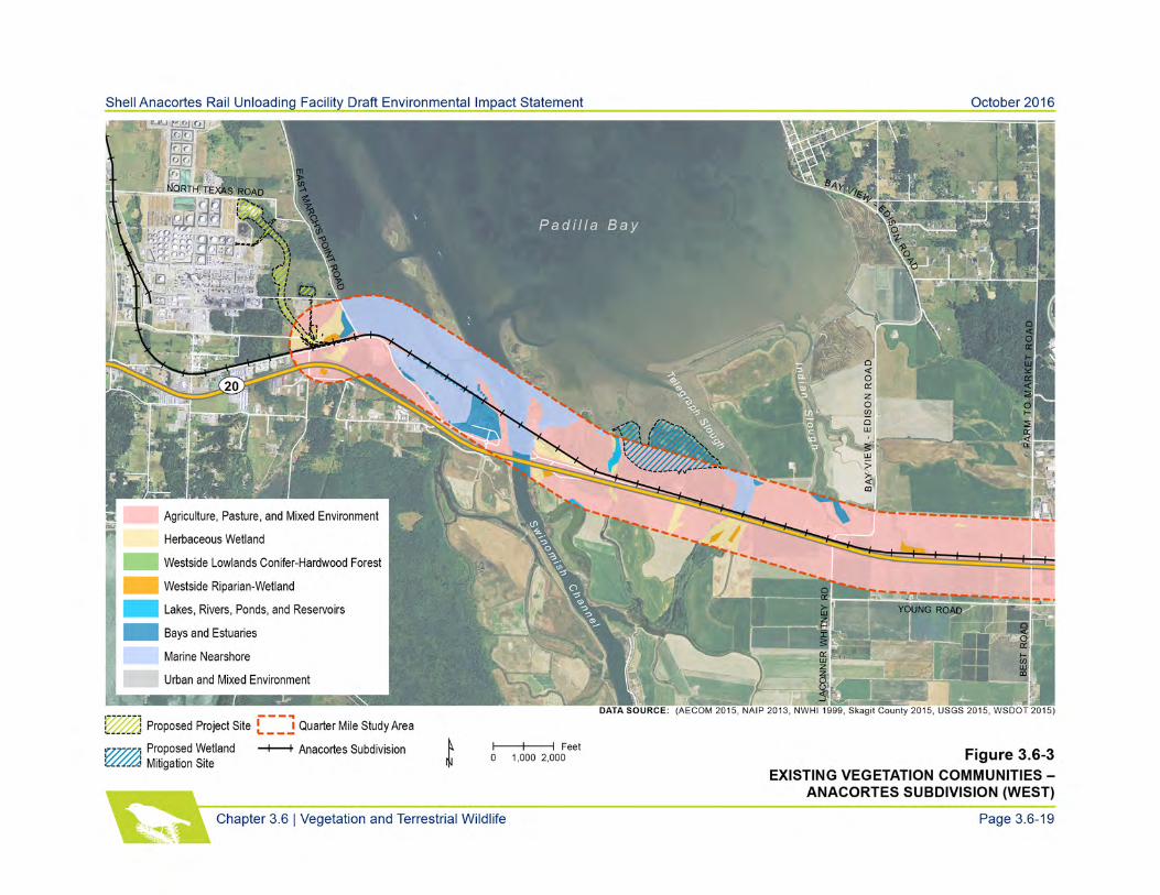
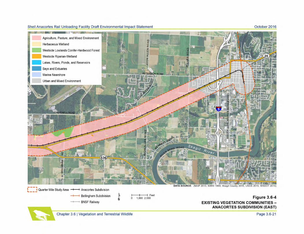
Table 3.6-6 and Figures 3.6-3 and 3.6-4 summarize and illustrate the vegetation communities
and their dominant vegetation and prevalence within the Anacortes Subdivision and surrounding
study area.
Shell Anacortes Rail Unloading Facility Draft Environmental Impact Statement October 2016
Chapter 3.6 | Vegetation and Terrestrial Wildlife Page 3.6-17
Table 3.6-6 Vegetation Communities and Land Cover Types – Anacortes Subdivision
Vegetation
Community/Land
Cover Type
Occurrence along the Anacortes Subdivision
and in the Surrounding Study Area
and Dominant Vegetation1
Prevalence in
this Portion
of the Study
Area
(approximate)
Agricultural, pasture
and mixed environs
This is the predominant vegetation community in this
portion of the study area. Intensively farmed croplands,
and modified grasslands support a wide variety of
commercial crops and feed for livestock production.
Fallow fields frequently flood in the winter.
70%
(2,431 acres)
Urban and mixed
environs
This cover type includes the Anacortes Subdivision, SR 20,
roads, industrial, commercial and residential sites, and the
City of Burlington. Sparse vegetation occurs near the edge
of rail and road rights of way. Residential and commercial
landscaping in the City of Burlington likely consists of non-
native and introduced ornamental plant species.
15%
(539 acres)
Marine nearshore This cover type includes Swinomish Channel at the mouth
of Padilla Bay and Telegraph Slough on the north side of SR
20. Patches of eelgrass are also present in deeper waters of
the channel and bay. See Chapter 3.4 – Fish and Aquatic
Species and Habitat, for more detail.
9%
(320 acres)
Herbaceous
wetlands
Large patches of emergent wetlands are associated with
Telegraph Slough and Blind Slough in the western portion of
the Anacortes Subdivision. Patches of non-farmed
emergent wetlands are scattered throughout croplands in
this area. Salt-tolerant grasses and forbs are expected to
be predominant near the relict sloughs, whereas invasive
species such as reed canarygrass are expected to be
predominant in wetlands adjoining croplands.
2%
(75 acres)
Bays and estuaries Includes estuarine wetlands fringing the Swinomish
Channel. Salt-tolerant grasses and forbs occur in this land
cover type.
2%
(58 acres)
Westside lowlands
conifer-hardwood
forest
One block of second-growth mixed deciduous and
coniferous forest is located south of the Skagit Regional
airport. Portions of the vegetation community have been
recently logged.
1%
(46 acres)
Westside riparian-
wetland
Patches of deciduous forest and shrub vegetation are
scattered throughout the area, and are mainly associated
with relict distributary channels in the Skagit Valley.
<1%
(12 acres)
Lakes, rivers, ponds
and reservoirs
Blind Slough, East Slough and other relict tidal channels
occur in the western portion of the study area. They do not
receive daily tidal input, but still contain shallow, brackish
water and support salt-tolerant forbs and grasses at the
margins.
<1%
(7 acres)
1. Sources: Skagit County 2016a, Mitchell et al. 2005.
Shell Anacortes Rail Unloading Facility Draft Environmental Impact Statement October 2016
Page 3.6-18 Chapter 3.6 | Vegetation and Terrestrial Wildlife
This page intentionally left blank

Shell Anacortes Rail Unloading Facility Draft Environmental Impact Statement October 2016
Page 3.6-20 Chapter 3.6 | Vegetation and Terrestrial Wildlife
This page intentionally left blank
Shell Anacortes Rail Unloading Facility Draft Environmental Impact Statement October 2016
Page 3.6-22 Chapter 3.6 | Vegetation and Terrestrial Wildlife
Special Status Plants
The Washington Natural Heritage Program (WNHP 2015) does not depict any special status
plants in the Anacortes Subdivision or surrounding study area. The nearest documented
occurrence of a special-status plant is of soft-leaved willow (Salix sessifolia), a State Sensitive
species, located more than 3 miles southeast of the rail line. Most of the special-status plant
species that potentially occur in the study area require undisturbed habitat ranging from open
grasslands to moist meadows, ponds, and lakes (WNHP 2016).
Noxious Weeds
Smooth cordgrass (Spartina alterniflora), a Skagit County Class A weed, occurs at Swinomish
Spit near the mouth of Padilla Bay (Riggs 2011). Other noxious weeds in the study area likely
originate from agricultural sources such as hay, feed, grain, and crops (Skagit County 2016b).
Noxious weeds in the City of Burlington may originate from wildflower seeds, bird seed,
ornamentals, and accidentally planted noxious species in residential and commercial landscapes.
Terrestrial Wildlife Species and Habitat
Terrestrial species and habitat evaluated include general wildlife habitat and common species
occurrences. This section also presents potential habitat for and occurrence of local, state, and
federal lists of terrestrial threatened and endangered species and species of concern, migratory
birds, and invasive terrestrial wildlife species.
Proposed Project Site
Wildlife Habitat and Common Species Occurrences
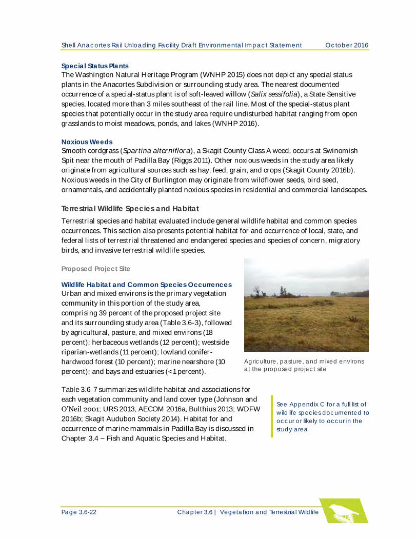
Urban and mixed environs is the primary vegetation
community in this portion of the study area,
comprising 39 percent of the proposed project site
and its surrounding study area (Table 3.6-3), followed
by agricultural, pasture, and mixed environs (18
percent); herbaceous wetlands (12 percent); westside
riparian-wetlands (11 percent); lowland conifer-
hardwood forest (10 percent); marine nearshore (10
percent); and bays and estuaries (<1 percent).
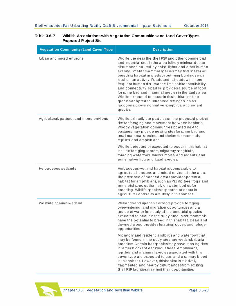
Table 3.6-7 summarizes wildlife habitat and associations for
each vegetation community and land cover type (Johnson and
O’Neil 2001; URS 2013, AECOM 2016a, Bulthius 2013; WDFW
2016b; Skagit Audubon Society 2014). Habitat for and
occurrence of marine mammals in Padilla Bay is discussed in
Chapter 3.4 – Fish and Aquatic Species and Habitat.
Callout box: See Appendix C for a full list of
wildlife species documented to
occur or likely to occur in the
study area. Callout box en d.
Agriculture, pasture, and mixed environs
at the proposed project site
Shell Anacortes Rail Unloading Facility Draft Environmental Impact Statement October 2016
Chapter 3.6 | Vegetation and Terrestrial Wildlife Page 3.6-23
Table 3.6-7 Wildlife Associations with Vegetation Communities and Land Cover Types –
Proposed Project Site
Vegetation Community/Land Cover Type Description
Urban and mixed environs Wildlife use near the Shell PSR and other commercial
and industrial sites in the area is likely minimal due to
disturbance caused by noise, lights, and other human
activity. Smaller mammal species may find shelter or
breeding habitat in sheds or out-lying buildings with
less human activity. Roads and railroads with more
frequent human disturbance limit habitat availability
and connectivity. Road kill provides a source of food
for some bird and mammal species in the study area.
Wildlife expected to occur in this habitat include
species adapted to urbanized settings such as
raccoons, crows, nonnative songbirds, and rodent
species.
Agricultural, pasture, and mixed environs Wildlife primarily use pastures on the proposed project
site for foraging and movement between habitats.
Woody vegetation communities located next to
pastures may provide nesting sites for some bird and
small mammal species, and shelter for mammals,
reptiles, and amphibians.
Wildlife detected or expected to occur in this habitat
include foraging raptors, migratory songbirds,
foraging waterfowl, shrews, moles, and rodents, and
some native frog and lizard species.
Herbaceous wetlands Herbaceous wetland habitat is comparable to
agricultural, pasture, and mixed environs in the area.
The presence of ponded areas provides potential
habitat for amphibians, such as Pacific tree frogs, and
some bird species that rely on water bodies for
breeding. Wildlife species expected to occur in
agricultural lands also are likely in this habitat.
Westside riparian-wetland Wetlands and riparian corridors provide foraging,
overwintering, and migration opportunities and a
source of water for nearly all the terrestrial species
expected to occur in the study area. Most mammals
have the potential to breed in this habitat. Dead and
downed wood provides foraging, cover, and refuge
opportunities.
Migratory and resident landbirds and waterfowl that
may be found in the study area are wetland/riparian
breeders. Certain bat species may have roosting sites
in larger blocks of deciduous trees. Amphibians,
reptiles, and mammal species associated with this
cover type are expected to use, and also may breed
in this habitat. However, this habitat is relatively
fragmented and nearby disturbances from existing
Shell PSR facilities may limit their opportunities.
Shell Anacortes Rail Unloading Facility Draft Environmental Impact Statement October 2016
Page 3.6-24 Chapter 3.6 | Vegetation and Terrestrial Wildlife
Vegetation Community/Land Cover Type Description
Lowland conifer-hardwood forest Dead and downed wood provides foraging, cover,
and refuge opportunities for amphibian, reptile, and
mammal species associated with this cover type.
Certain bird species also use downed wood for
perching, foraging, cover, and nesting. Snags provide
potential resting, roosting and nesting, and refugia
habitat. Some mammals and reptiles may use forest
stands for breeding. Live trees and shrubs provide
food and cover for mammals and nesting sites for
birds.
Cavity-nesting birds, bats, songbirds, salamanders,
and mammals such as deer, raccoons, and smaller
mammals may use this habitat for a range of life
history needs.
Marine nearshore
The portion of Padilla Bay nearest to the Shell PSR site
provides key habitat for migrating and overwintering
shorebirds. Eelgrass beds in deeper portions of the
bay provide habitat for dozens of species of
migrating and overwintering dabbling and diving
ducks, piscivorous birds, and offer a key stopover site
for the black brant, also known as Pacific brent goose
(Branta bernicla nigricans). This area also serves as
key winter habitat for a unique population of Western
High Artic Brant, also known as Grey-belly Brant
(Branta bernicula). This WDFW priority habitat is
discussed in Special Status Species and Habitat later
in this analysis.
Bays and estuaries Estuarine wetlands and bays adjoining the Shell PSR
facility provide stopover sites for migrating shorebirds,
waterfowl, and other waterbirds. This habitat is also a
food source for resident and overwintering waterfowl,
birds of prey, and gulls that occur in the study area.
The vegetated estuarine wetlands have potential
nesting habitat for herons and heron-like birds, rails,
and other water-associated birds that breed in the
Puget Lowlands. Bats may forage over open water.
Amphibians generally are not associated with this
habitat, although northern red-legged frogs may
breed in brackish water.
Wetland Mitigation Site
Wildlife Habitat and Common Species Occurrences
Marine nearshore and westside riparian-wetland are the primary vegetation communities at the
wetland mitigation site and surrounding study area, each comprising 31 percent of the area
(Table 3.6-4). These communities are followed in dominance by agricultural, pasture, and mixed
environs (18 percent); urban and mixed environs (13 percent); herbaceous wetlands (6 percent);
and lakes, rivers, and ponds (1 percent).
Shell Anacortes Rail Unloading Facility Draft Environmental Impact Statement October 2016
Chapter 3.6 | Vegetation and Terrestrial Wildlife Page 3.6-25
Table 3.6-8 summarizes wildlife habitat and species associations for each vegetation community
and land cover type (URS 2013, AECOM 2016a, Bulthius 2013; WDFW 2016b; Skagit Audubon
Society 2014). Appendix C provides a full list of wildlife species documented to occur or likely to
occur in the study area.
Table 3.6-8 Wildlife Associations with Vegetation Communities and Land Cover Types –
Wetland Mitigation Site
Vegetation Community/Land Cover Type Description
Marine Nearshore Padilla Bay provides key habitat for bird species
comparable to those described for the proposed
project site; the bay is also designated as WDFW
priority habitat. Telegraph Slough is part of WDFW’s
Skagit Wildlife Area and provides opportunities for
bird watching, waterfowl hunting, and wildlife
viewing. A private hunting club uses the nearshore
habitat of Padilla Bay waterward of the existing dikes.
River otters have been observed near tidal flats.
Westside riparian-wetland The wetland mitigation site has larger contiguous,
relatively undisturbed blocks of habitat and is
generally surrounded by less development. There is
greater opportunity for landbirds, waterfowl,
amphibians, reptiles, and mammals associated with
this cover type to use and breed in this habitat
compared with the proposed project site.
Agricultural, pasture, and mixed environs Foraging is likely the most common activity of wildlife
in intensely farmed croplands located to the south of
the wetland mitigation site. Breeding habitat is
minimal due to the ephemeral nature of potential
nesting structures. Some species may breed in
adjoining windbreaks, fence rows, and field borders
that are not actively managed. Agricultural fields are
key stopover habitat for Neotropical migratory birds,
geese, and swans. Foraging raptors and large-to-
small-stature mammals also use this habitat.
Urban and mixed environs Wildlife that use undisturbed areas in the poplar farm
may traverse residences and roads. State Route (SR)
20 and the Anacortes Subdivision have fragmented
habitat and may limit wildlife movement between
habitats. However, some mammals likely have
adapted to using the Anacortes Subdivision as a
corridor because rail traffic is less frequent than
vehicular traffic on SR 20. Road kill provides a source
of food for some bird and mammal species that
occur in the study area.
Herbaceous wetlands Herbaceous wetland habitat interspersed within the
hybrid poplar stands provide opportunity for
amphibian breeding and for a variety of birds to
forage and rest.
Shell Anacortes Rail Unloading Facility Draft Environmental Impact Statement October 2016
Page 3.6-26 Chapter 3.6 | Vegetation and Terrestrial Wildlife
Vegetation Community/Land Cover Type Description
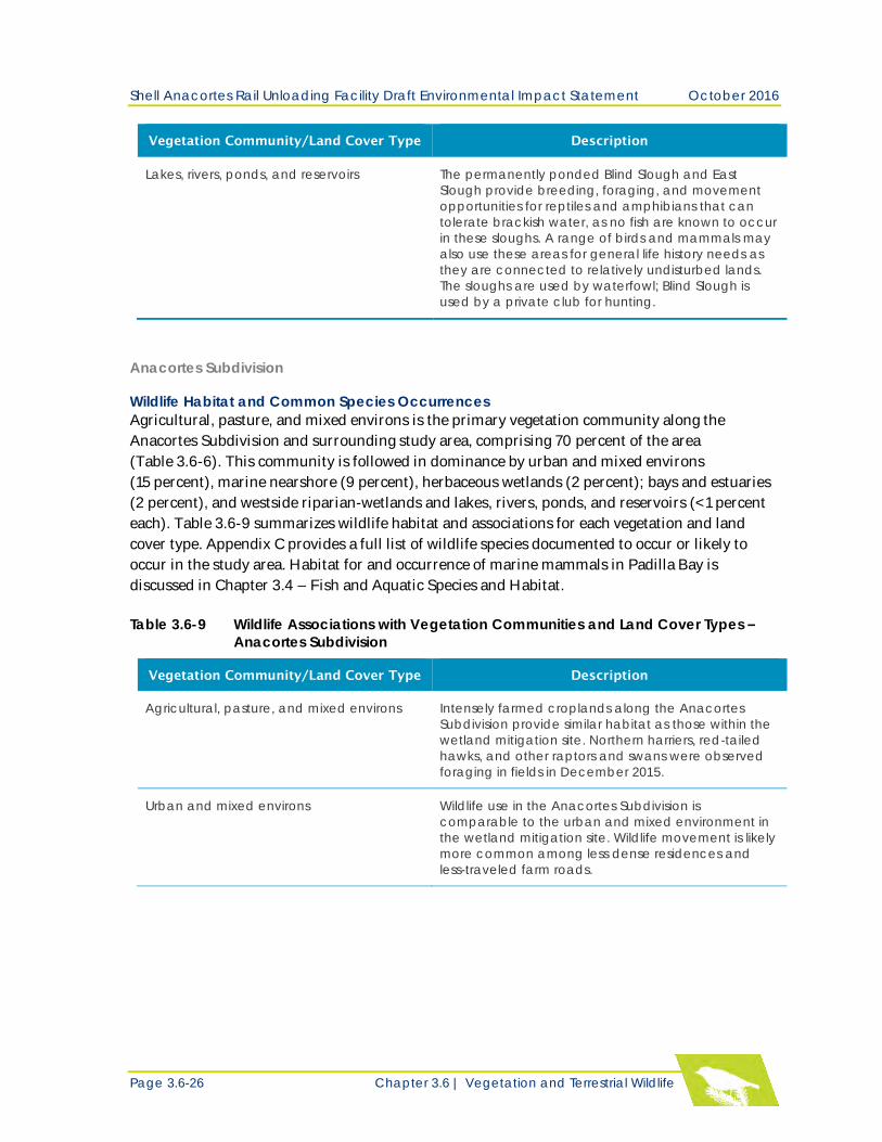
Lakes, rivers, ponds, and reservoirs The permanently ponded Blind Slough and East
Slough provide breeding, foraging, and movement
opportunities for reptiles and amphibians that can
tolerate brackish water, as no fish are known to occur
in these sloughs. A range of birds and mammals may
also use these areas for general life history needs as
they are connected to relatively undisturbed lands.
The sloughs are used by waterfowl; Blind Slough is
used by a private club for hunting.
Anacortes Subdivision
Wildlife Habitat and Common Species Occurrences
Agricultural, pasture, and mixed environs is the primary vegetation community along the
Anacortes Subdivision and surrounding study area, comprising 70 percent of the area
(Table 3.6-6). This community is followed in dominance by urban and mixed environs
(15 percent), marine nearshore (9 percent), herbaceous wetlands (2 percent); bays and estuaries
(2 percent), and westside riparian-wetlands and lakes, rivers, ponds, and reservoirs (<1 percent
each). Table 3.6-9 summarizes wildlife habitat and associations for each vegetation and land
cover type. Appendix C provides a full list of wildlife species documented to occur or likely to
occur in the study area. Habitat for and occurrence of marine mammals in Padilla Bay is
discussed in Chapter 3.4 – Fish and Aquatic Species and Habitat.
Table 3.6-9 Wildlife Associations with Vegetation Communities and Land Cover Types –
Anacortes Subdivision
Vegetation Community/Land Cover Type Description
Agricultural, pasture, and mixed environs Intensely farmed croplands along the Anacortes
Subdivision provide similar habitat as those within the
wetland mitigation site. Northern harriers, red-tailed
hawks, and other raptors and swans were observed
foraging in fields in December 2015.
Urban and mixed environs Wildlife use in the Anacortes Subdivision is
comparable to the urban and mixed environment in
the wetland mitigation site. Wildlife movement is likely
more common among less dense residences and
less-traveled farm roads.
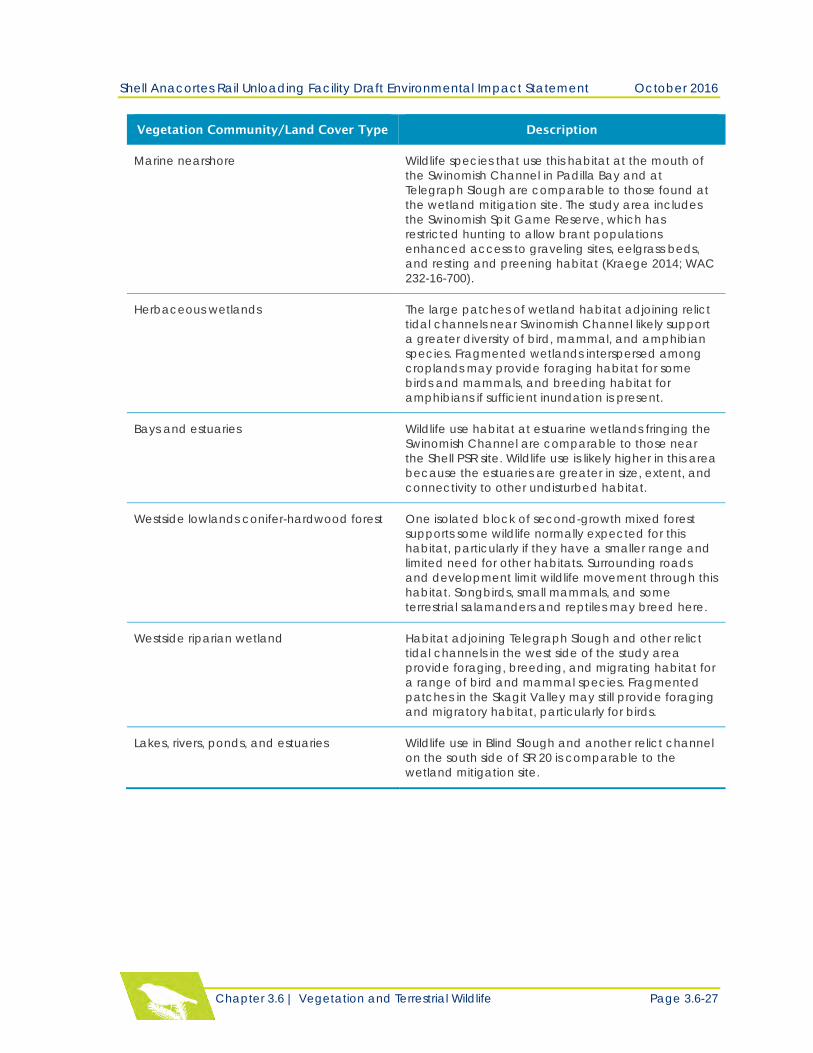
Shell Anacortes Rail Unloading Facility Draft Environmental Impact Statement October 2016
Chapter 3.6 | Vegetation and Terrestrial Wildlife Page 3.6-27
Vegetation Community/Land Cover Type Description
Marine nearshore Wildlife species that use this habitat at the mouth of
the Swinomish Channel in Padilla Bay and at
Telegraph Slough are comparable to those found at
the wetland mitigation site. The study area includes
the Swinomish Spit Game Reserve, which has
restricted hunting to allow brant populations
enhanced access to graveling sites, eelgrass beds,
and resting and preening habitat (Kraege 2014; WAC
232-16-700).
Herbaceous wetlands The large patches of wetland habitat adjoining relict
tidal channels near Swinomish Channel likely support
a greater diversity of bird, mammal, and amphibian
species. Fragmented wetlands interspersed among
croplands may provide foraging habitat for some
birds and mammals, and breeding habitat for
amphibians if sufficient inundation is present.
Bays and estuaries Wildlife use habitat at estuarine wetlands fringing the
Swinomish Channel are comparable to those near
the Shell PSR site. Wildlife use is likely higher in this area
because the estuaries are greater in size, extent, and
connectivity to other undisturbed habitat.
Westside lowlands conifer-hardwood forest One isolated block of second-growth mixed forest
supports some wildlife normally expected for this
habitat, particularly if they have a smaller range and
limited need for other habitats. Surrounding roads
and development limit wildlife movement through this
habitat. Songbirds, small mammals, and some
terrestrial salamanders and reptiles may breed here.
Westside riparian wetland Habitat adjoining Telegraph Slough and other relict
tidal channels in the west side of the study area
provide foraging, breeding, and migrating habitat for
a range of bird and mammal species. Fragmented
patches in the Skagit Valley may still provide foraging
and migratory habitat, particularly for birds.
Lakes, rivers, ponds, and estuaries Wildlife use in Blind Slough and another relict channel
on the south side of SR 20 is comparable to the
wetland mitigation site.
Shell Anacortes Rail Unloading Facility Draft Environmental Impact Statement October 2016
Page 3.6-28 Chapter 3.6 | Vegetation and Terrestrial Wildlife
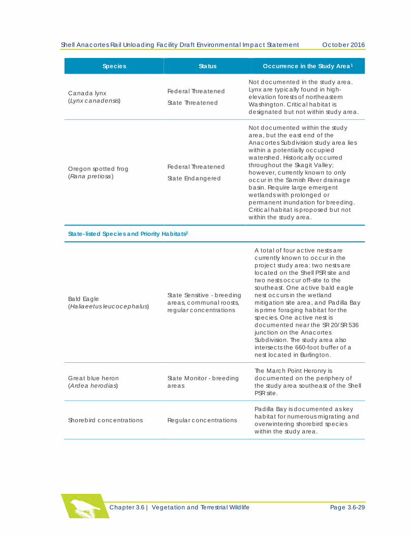
Special Status Wildlife and Habitats – Study Area
Special-Status wildlife and habitats include the following:
Federal proposed, candidate, threatened, and endangered species and critical habitat, and
species that are managed by the Endangered Species Program of the USFWS.
State Endangered, Threatened, Sensitive, and Candidate species; animal aggregations (e.g.,
heron colonies, bat colonies) considered vulnerable; and species of recreational, commercial,
or tribal importance that are vulnerable.
Table 3.6-10 summarizes special status species that are known to occur or potentially occur in
the study area. No federally designated or proposed critical habitat for terrestrial species is
documented in the study area. Although it is noted that the Biological Evaluation prepared for
the project (AECOM 2016a) does not include the Anacortes Subdivision as part of its action area.
Several state-sensitive species (WDFW 2016a) and/or priority areas associated with those
species are found in the study area. Species with documented occurrences in the study area are
discussed below.
Table 3.6-10 Special Status Wildlife Species Documented or Potentially Occurring in the
Study Area
Species Status Occurrence in the Study Area1
Federally-listed Species and Critical Habitat
Marbled Murrelet
(Brachyramphus marmoratus)
Federal Threatened
State Threatened
No breeding habitat but potential
foraging habitat is documented in the
study area. Critical habitat is
designated but not within study area.
Streaked Horned Lark
(Eremophila alpestris strigata)
Federal Threatened
State Endangered
Not documented in the study area.
Inhabits sparsely vegetated
grasslands, beaches, islands, and
agricultural fields. Currently breeds in
south Puget lowlands, coastal sites,
and Columbia River sites. Critical
habitat is designated but not within
study area.
Yellow-billed Cuckoo Western
Distinct Population Segment
(DPS)
(Coccyzus americanus)
Federal Threatened
State Candidate
Not documented in the study area.
Prefers large contiguous riparian
zones for breeding. Smaller patches
of woody vegetation may provide
migratory habitat. Not documented
in Puget lowlands since the 1940s.
Critical habitat is proposed but not
within study area.
Shell Anacortes Rail Unloading Facility Draft Environmental Impact Statement October 2016
Chapter 3.6 | Vegetation and Terrestrial Wildlife Page 3.6-29
Species Status Occurrence in the Study Area1
Canada lynx
(Lynx canadensis)
Federal Threatened
State Threatened
Not documented in the study area.
Lynx are typically found in high-
elevation forests of northeastern
Washington. Critical habitat is
designated but not within study area.
Oregon spotted frog
(Rana pretiosa)
Federal Threatened
State Endangered
Not documented within the study
area, but the east end of the
Anacortes Subdivision study area lies
within a potentially occupied
watershed. Historically occurred
throughout the Skagit Valley;
however, currently known to only
occur in the Samish River drainage
basin. Require large emergent
wetlands with prolonged or
permanent inundation for breeding.
Critical habitat is proposed but not
within the study area.
State-listed Species and Priority Habitats2
Bald Eagle
(Haliaeetus leucocephalus)
State Sensitive - breeding
areas, communal roosts,
regular concentrations
A total of four active nests are
currently known to occur in the
project study area: two nests are
located on the Shell PSR site and
two nests occur off-site to the
southeast. One active bald eagle
nest occurs in the wetland
mitigation site area, and Padilla Bay
is prime foraging habitat for the
species. One active nest is
documented near the SR 20/SR 536
junction on the Anacortes
Subdivision. The study area also
intersects the 660-foot buffer of a
nest located in Burlington.
Great blue heron
(Ardea herodias)
State Monitor - breeding
areas
The March Point Heronry is
documented on the periphery of
the study area southeast of the Shell
PSR site.
Shorebird concentrations Regular concentrations
Padilla Bay is documented as key
habitat for numerous migrating and
overwintering shorebird species
within the study area.
Shell Anacortes Rail Unloading Facility Draft Environmental Impact Statement October 2016
Page 3.6-30 Chapter 3.6 | Vegetation and Terrestrial Wildlife
Species Status Occurrence in the Study Area1
Waterfowl concentrations Regular concentrations
Padilla Bay is documented as key
habitat for migrating and
overwintering waterfowl species
within the study area.
1. Sources: AECOM 2016a, USFWS 2016a,b, WDFW 2016a, WDFW 2015, URS unpublished undated data, Padilla Bay
NERR 2016, WSDOT 2015, Danilson et al. 2013.
2. WDFW (2008) regulates most species as priority only within areas with known limiting habitats (e.g., breeding
areas) or within areas that support a relatively high number of individuals (e.g., regular large concentrations). If
limiting habitats are not known, or if a species is so rare that any occurrence is important in land use decisions,
then the priority area for a species is described as “any occurrence.”
Federally-Listed Species
Marbled Murrelet Marbled murrelets primarily nest in old growth forests, which are absent from the rail project
area; however, they forage in waters up to 55 miles from their nesting habitat (AECOM 2016a).
Padilla Bay is within the foraging range of potential marbled murrelet nesting habitat; the bay
also provides a source of nearshore forage fish such as Pacific sand lance, Pacific herring,
northern anchovy, and capelin. Marbled murrelets are noted to occur in Padilla Bay, in which
they are considered uncommon (may be seen or heard in primary habitat) in fall, winter, and
spring, and occasional-to-rare (unlikely to be seen or heard, but may be in the area) in summer
(Padilla Bay NERR no date).
State-Listed Species and Priority Habitats
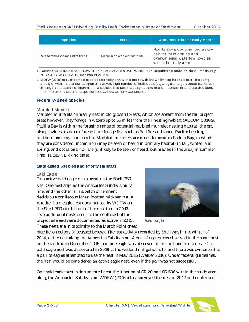
Bald Eagle Two active bald eagle nests occur on the Shell PSR
site. One nest adjoins the Anacortes Subdivision rail
line, and the other is in a patch of remnant
deciduous/coniferous forest located mid-peninsula.
Another bald eagle nest documented by WDFW on
the Shell PSR site fell out of the nest tree in 2013.
Two additional nests occur to the southeast of the
project site and were documented as active in 2013. Bald eagle
These nests are in proximity to the March Point great
blue heron colony (discussed below). The last activity recorded by Shell was in the winter of
2014, at the nest along the Anacortes Subdivision. A pair of eagles was observed in the same nest
on the rail line in December 2015, and one eagle was observed at the mid-peninsula nest. One
bald eagle nest was discovered in 2016 at the wetland mitigation site, and there was evidence that
a pair of eagles attempted to use the nest in May 2016 (Walker 2016). Under federal guidelines,
the nest would be considered an active eagle nest, even if the pair was not successful.
One bald eagle nest is documented near the junction of SR 20 and SR 536 within the study area
along the Anacortes Subdivision. WDFW (2016c) last surveyed the nest in 2012 and confirmed
Shell Anacortes Rail Unloading Facility Draft Environmental Impact Statement October 2016
Chapter 3.6 | Vegetation and Terrestrial Wildlife Page 3.6-31
that it was active, with two young nestlings detected. The east end of the study area intersects theedge of a 660-foot buffer of an additional eagle nest located outside of the study area. The 660- foot buffer is a protection zone established to minimize human disturbance to active nests (USFWS 2007). WDFW (2016d) last surveyed the nest in 2009 and confirmed that it was active; two young nestlings were also detected.
In western Washington, territorial eagles generally engage in courtship behavior in January and February. Most eagles begin to incubate their eggs by the third week in March and young hatch by late April (Watson 2006); however, the start of the nesting period for individual pairs can vary considerably year to year (Stinson et al. 2007). Incubation lasts for about 35 days and most young eagles fledge at 11 to 13 weeks, usually during early to mid-July (Watson 2006). Padilla Bay is prime foraging habitat for bald eagles who feed on fish, waterfowl, gull and seabird roosts, as well as the eggs and young of colony-nesting birds, including great blue heron.
Great Blue Heron The March Point Heronry is a highly productive colony that is considered one of the largest in western North America (Skagit Land Trust 2016). It is located in a stand of mixed coniferous/deciduous forest surrounded by industrial businesses, SR 20, the Anacortes Subdivision rail line, and other roads. Skagit Land Trust (2016) counted 300 nests on accessible land in 2014. The total number of nests is likely higher considering nests that were not counted on private properties (Skagit Land Trust 2016). The heronry is typically occupied from March to August. Egg laying generally occurs in April, although 2015 observations indicate egg laying started as early as March (Eissinger 2007; Padilla Bay NERR 2016). Young are hatched, reared, and fledged from May to July-August (Eissinger 2007). Herons forage for fish, frogs, and small mammals in Fidalgo and Padilla bays and farmlands in the Skagit Valley. Bald eagles are the primary natural predator of heron eggs and young, particularly in denser eagle nest territories in coastal areas, and are the cause of nest failure in some colonies (Eissinger 2007). However, nearby nesting bald eagles may provide herons and their young some protection from other predators including crows, ravens, and raccoons (Padilla Bay NERR 2009). There is no known published data for bald eagle predation in the March Point Heronry. Shorebird and Waterfowl Concentrations Padilla Bay is an extensive shallow bay with associated mudflats and sloughs and contains some of the most extensive eelgrass beds on the West Coast (WDFW 2016; Audubon Society 2016). These sheltered bays and sloughs serve as a critical wintering area for seabirds, ducks, and geese, and provide shelter and food for the large concentrations of waterfowl. Wintering waterfowl use the bay for loafing habitat and graveling sites. Padilla Bay is one of the remaining important overwintering sites for migrating brants, although they also use Padilla Bay as a staging area during autumn and spring migrations (Bulthius 2013). Herbivorous brants feed almost exclusively on eelgrass in the bay. Other large concentrations of birds documented in the bay include mallards, pintails, green-winged teal, wigeons, dunlins, western sandpipers, and black- bellied plovers (Bulthius 2013; WDFW 2016a).
Shell Anacortes Rail Unloading Facility Draft Environmental Impact Statement October 2016
Page 3.6-32 Chapter 3.6 | Vegetation and Terrestrial Wildlife
Other Protected Wildlife Species
Other species of special interest include those that receive protection but are neither federally- or
state-listed, nor considered state priority species. The federal Migratory Bird Treaty Act protects
migratory birds including raptors, some species of gulls, waterfowl, swallows, and owls, as well as
their eggs, parts, and nests (WSDOT 2006). Skagit County (Chapter 14.24.500 SCC) also
designates Fish and Wildlife Habitat Conservation Areas on a site-specific basis according to the
official Habitats and Species of Local Importance Map.
Invasive Terrestrial Wildlife
The Washington Invasive Species Council (2011) identifies two priority invasive terrestrial
animal species that have the potential to affect native plants, animals, and ecosystems in
Washington State—feral swine (Sus scrofa) and nutria (Myocastor coypu). Neither species has
been detected in or near the proposed project or wetland mitigation sites. However, nutria are
reported in Skagit County, particularly in canals and ditches, dikes and levees, and reservoirs
(EDDMapS 2016; Washington Invasive Species Council 2011) and may occur in canals and
ditches in agricultural lands along the Anacortes Subdivision. Agricultural pests regulated under
the Washington Administrative Code (WAC, Title 16) are not addressed in this document.
ENVIRONMENTAL IMPACTS
No Action Alternative
Because no construction or operation would take place under the no action alternative, there
would be no impacts to terrestrial vegetation or wildlife habitat. The no action alternative
includes continued maintenance and repair activities necessary to keep the Anacortes
Subdivision rail line operational; therefore, existing land uses would remain the same. Any
significant changes to vegetation and wildlife habitat and species occurrences would be driven by
trends not related to this project. The proposed wetland mitigation would not be implemented,
which would preclude restoration of estuarine and nearshore habitat that historically occurred at
the wetland mitigation site.
Proposed Project Site
Direct Impacts to Vegetation
Construction
Removal of vegetation would be required to construct the project. The cleared areas would be
necessary to accommodate the proposed facility features described in Chapter 2 – Proposed
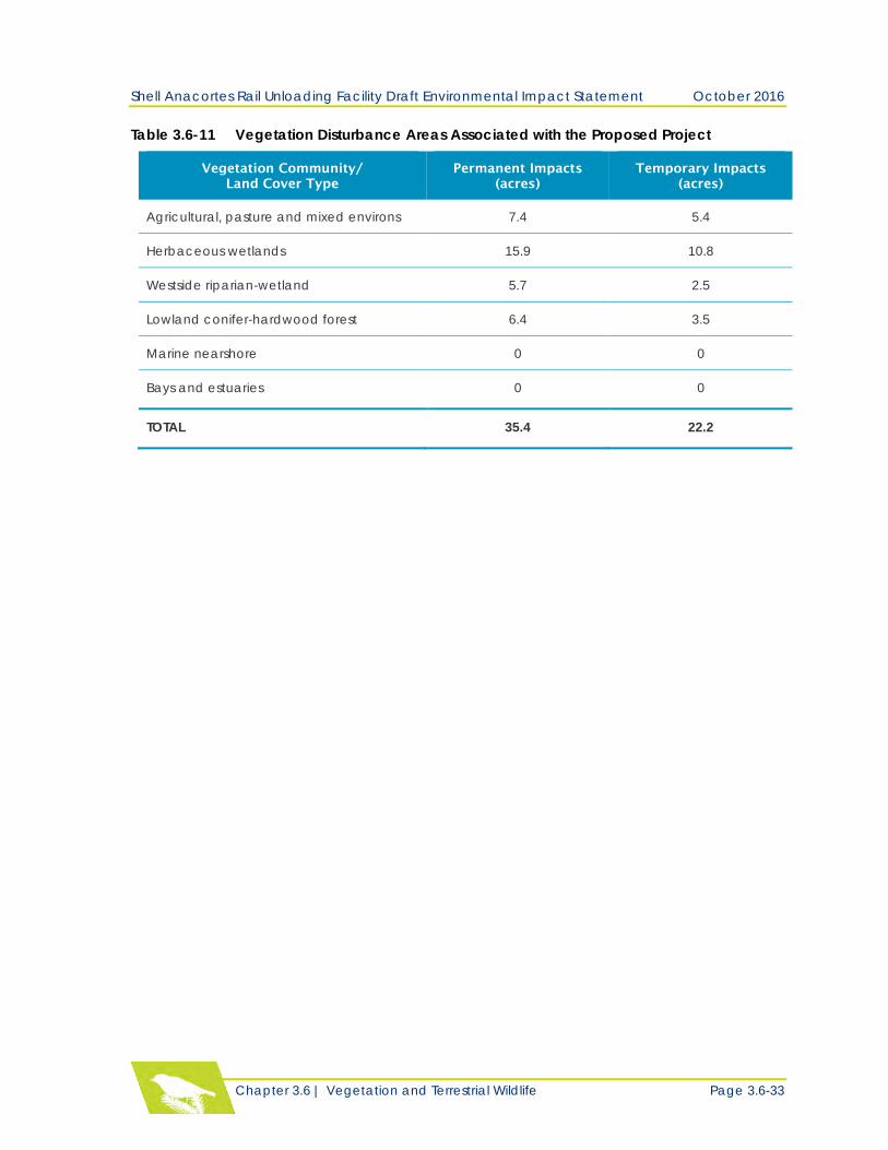
Project and Alternatives. Table 3.6-11 identifies the area of temporary and permanent clearing
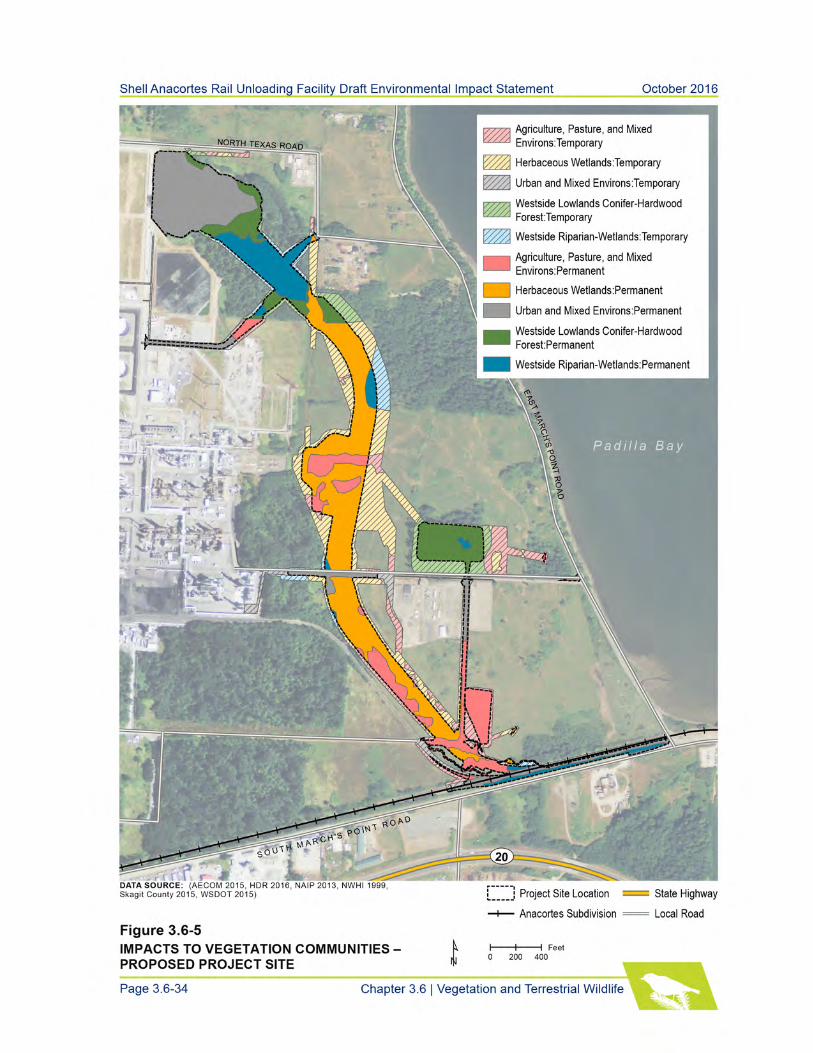
and the dominant vegetation type. Figure 3.6-5 illustrates the overall impacts the proposed
project could have on vegetation communities.
Shell Anacortes Rail Unloading Facility Draft Environmental Impact Statement October 2016
Chapter 3.6 | Vegetation and Terrestrial Wildlife Page 3.6-33
Table 3.6-11 Vegetation Disturbance Areas Associated with the Proposed Project
Vegetation Community/
Land Cover Type
Permanent Impacts
(acres)
Temporary Impacts
(acres)
Agricultural, pasture and mixed environs 7.4 5.4
Herbaceous wetlands 15.9 10.8
Westside riparian-wetland 5.7 2.5
Lowland conifer-hardwood forest 6.4 3.5
Marine nearshore 0 0
Bays and estuaries 0 0
TOTAL 35.4 22.2
Shell Anacortes Rail Unloading Facility Draft Environmental Impact Statement October 2016
Chapter 3.6 | Vegetation and Terrestrial Wildlife Page 3.6-35
Most of this affected acreage consists of heavily grazed wetland and upland pasture. To the
extent feasible, Shell would minimize disturbance to vegetation communities by using existing
roads, and cleared areas for staging and access to construction sites.
Construction impacts would be temporary (approximately two years in duration), and would be
limited to the period during and immediately following construction. Upon completion of
construction, herbaceous wetland and upland areas would be replanted with native grass and
forb species. To accommodate rerouted pipelines and retaining walls, approximately 1.22 acres of
temporarily affected forested and scrub-shrub wetlands would be converted to emergent
wetlands comprised of native herbaceous vegetation. Approximately 0.23 acre of forested
wetlands and 2.11 acres of forested wetland buffers would be restored with native trees and
shrubs.
The overall permanent impacts of construction on vegetation are not anticipated to be significant
because the primary impacts to pasture vegetation are small-scale in the context of the larger
contributing Telegraph Slough-Padilla Bay watershed, which is predominantly agriculture and
pasture. Forest stands that would be permanently affected comprise approximately 9 percent of
forest habitat identified in the study area. The remainder of the forested vegetation communities
would not be affected. The project would have negligible impacts on the extent and connectivity,
and overall integrity of forest habitat used by wildlife including migratory birds in the immediate
Telegraph Slough-Padilla Bay watershed.
Construction of the proposed project is not expected to affect special-status plant species because
no plant species or potentially suitable habitat were identified (WNHP 2016). If special-status
plant species were present in the construction area, construction activities could affect them
through trampling, removal of individuals, habitat degradation, potential spread and
colonization of noxious weeds, or erosion and sedimentation. The overall impact of the proposed
project on special-status plants is expected to be insignificant. Disturbance to vegetated areas
would be mainly within heavily grazed pastures that are unlikely to provide suitable habitat for
special-status plant species. Construction may increase the risk of introducing or contributing to
the spread of noxious weed species.
Operation
Following construction of the proposed project, operation of the facility is not anticipated to
disturb vegetation communities. Ongoing maintenance activities for other facilities are not
anticipated to require additional clearing or grading outside the final facility footprint.
Indirect Impacts to Vegetation
Indirect, long-term impacts to vegetation could result from the impacts identified above, such as
modification of vegetation, partial shading of wetland vegetation, water quality degradation, and
alteration of wetland hydrology sources. The proposed project could also indirectly affect
vegetation through the potential spread of nonnative plants and noxious weeds from ground-
disturbing activities and dispersal from construction equipment and personnel. The indirect

Shell Anacortes Rail Unloading Facility Draft Environmental Impact Statement October 2016
Page 3.6-36 Chapter 3.6 | Vegetation and Terrestrial Wildlife
impacts from the temporary and permanent footprint of the proposed project are expected to be
localized and insignificant with the implementation of minimization measures and BMPs.
Additional trains entering the Shell PSR that are proposed under this project are unlikely to
contribute substantially to the dispersal of invasive plant species because the unit trains would
not carry cargo such as agricultural or food products that could be a source for invasive plant
species.
Direct Impacts to Wildlife
Construction Impacts to General Wildlife and Habitat
Construction of the proposed project would temporarily disturb and permanently alter wildlife
habitat in the vegetation communities described above. Removing trees, snags, and understory
vegetation for the project would result in the loss of potential nesting and foraging sites for many
species of birds, as well as reduce the availability of hiding cover for small mammals, and
roosting and foraging sites for bats. Earthwork on the site may result in mortality of individual
ground-dwelling species such as amphibians and small mammals that cannot flee a construction
area.
Construction-related water quality impacts may alter foraging opportunities for waterfowl and
other aquatic birds because of disturbances to sediments through in-water work, which could
cause water clouding and obscure prey for waterfowl and other aquatic birds. Sedimentation may
also affect amphibian breeding habitat due to deposition and settling of sediment particles on
eggs. Spills of oil, gasoline, concrete, or other toxic substances have the potential to poison or
injure waterfowl, and other wildlife.
Noise and light associated with construction activity can disturb wildlife by causing stress and
altering behavior patterns, thereby interfering with activities such as reproduction and feeding.
Construction would occur for a period of up to two years and take place during daytime hours.
Habitat within 1,045 feet of the construction area could be disturbed from noise. Loud activities
could cause some wildlife to move elsewhere, or discourage them from using adjacent habitats.
The degree of disturbance would depend on noise level, timing, and duration of construction
activities, as well as the sensitivity of the individual species. In the spring and summer months,
nesting and rearing activities may be disrupted for amphibians and songbirds whose breeding
habitat is more likely to occur near the proposed construction activities. However, this
disturbance would be temporary and would not result in a long-term impact to breeding animals
after construction is complete.
Nighttime construction is not anticipated at this time; however, lighting associated with potential
nighttime construction activities and security operations could be a disturbance, particularly to
nocturnal species. In general, most wildlife species found in developed areas are expected to be
more adapted to urban conditions, highway noise, and other human disruptions. Wildlife
associated with less developed or undeveloped habitat is expected to be less adapted to
construction activities. Construction impacts from vegetation removal and earthwork are not
anticipated to be significant. Although these activities could result in mortality of some
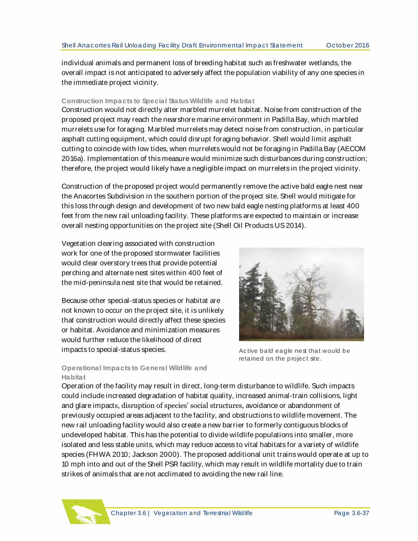
Shell Anacortes Rail Unloading Facility Draft Environmental Impact Statement October 2016
Chapter 3.6 | Vegetation and Terrestrial Wildlife Page 3.6-37
individual animals and permanent loss of breeding habitat such as freshwater wetlands, the
overall impact is not anticipated to adversely affect the population viability of any one species in
the immediate project vicinity.
Construction Impacts to Special Status Wildlife and Habitat
Construction would not directly alter marbled murrelet habitat. Noise from construction of the
proposed project may reach the nearshore marine environment in Padilla Bay, which marbled
murrelets use for foraging. Marbled murrelets may detect noise from construction, in particular
asphalt cutting equipment, which could disrupt foraging behavior. Shell would limit asphalt
cutting to coincide with low tides, when murrelets would not be foraging in Padilla Bay (AECOM
2016a). Implementation of this measure would minimize such disturbances during construction;
therefore, the project would likely have a negligible impact on murrelets in the project vicinity.
Construction of the proposed project would permanently remove the active bald eagle nest near
the Anacortes Subdivision in the southern portion of the project site. Shell would mitigate for
this loss through design and development of two new bald eagle nesting platforms at least 400
feet from the new rail unloading facility. These platforms are expected to maintain or increase
overall nesting opportunities on the project site (Shell Oil Products US 2014).
Vegetation clearing associated with construction
work for one of the proposed stormwater facilities
would clear overstory trees that provide potential
perching and alternate nest sites within 400 feet of
the mid-peninsula nest site that would be retained.
Because other special-status species or habitat are
not known to occur on the project site, it is unlikely
that construction would directly affect these species
or habitat. Avoidance and minimization measures
would further reduce the likelihood of direct
impacts to special-status species.
Operational Impacts to General Wildlife and
Habitat
Operation of the facility may result in direct, long-term disturbance to wildlife. Such impacts
could include increased degradation of habitat quality, increased animal-train collisions, light
and glare impacts, disruption of species’ social structures, avoidance or abandonment of
previously occupied areas adjacent to the facility, and obstructions to wildlife movement. The
new rail unloading facility would also create a new barrier to formerly contiguous blocks of
undeveloped habitat. This has the potential to divide wildlife populations into smaller, more
isolated and less stable units, which may reduce access to vital habitats for a variety of wildlife
species (FHWA 2010; Jackson 2000). The proposed additional unit trains would operate at up to
10 mph into and out of the Shell PSR facility, which may result in wildlife mortality due to train
strikes of animals that are not acclimated to avoiding the new rail line.
Active bald eagle nest that would be
retained on the project site.
Shell Anacortes Rail Unloading Facility Draft Environmental Impact Statement October 2016
Page 3.6-38 Chapter 3.6 | Vegetation and Terrestrial Wildlife
Operational noise from the project may result in wildlife avoidance in the immediate vicinity of
the new facility (Kaseloo and Tyson 2004); however, this impact is anticipated to be negligible,
given the noise from existing operations on the Shell PSR site and other surrounding
development. The noise impact analysis presented in Chapter 3.9 – Noise and Vibration,
determined that noise resulting from the proposed addition of six train trips per week, on
average, which includes intermittent, short horn blasts that may be required on the rail spur for
safety reasons, would attenuate to background noise levels within 100 feet of either side of the
new tracks. Operational noise may cause short-term species avoidance of the rail line when trains
are present, and long-term avoidance of the site by certain species within 100 feet of the rail line.
However, wildlife behavior is not anticipated to be significantly altered by operational noise.
Potential impacts from an accidental oil spill to surface water are addressed in Chapter 3.3 –
Surface Water.
Operational Impacts to Special-Status Species
Operation of the proposed project has the potential to affect behavior of bald eagles. Operation
and maintenance of stormwater facilities near the retained bald eagle nest would increase human
activity within 200 feet of the existing nest. Forested vegetation surrounding the nest would be
permanently removed, making human activity visible from the nest.
Generally, human activity within 660 feet of an active nest may cause eagles to become agitated,
which could result in inadequate nest repair, expenditure of energy defending the nest rather
than tending to their young, or abandonment of the nest altogether (USFWS 2007). Operation of
the proposed facility could have a significant impact on bald eagles if there is a net loss of nesting
habitat on the project site. However, in accordance with the conditions of the USFWS bald eagle
take permit that authorizes Shell to clear vegetation within 660 feet of the nest, Shell is required
to monitor the nest for eagle use during critical months and report activity to the USFWS.
Noise from train operation is not anticipated to affect bald eagles. As described above, noise from
train operations is expected to attenuate to background noise levels within 100 feet of the
proposed rail spur. The retained bald eagle nest and proposed nest platforms would be at least
400 feet away from the rail spur, and are not anticipated to be significantly affected by noise
from project operations.
Operation of the proposed project may also affect behavior of great blue herons at the March
Point Heronry, particularly light pollution. However, lights in the proposed facility would be
shielded and directed downward. The photometric analysis conducted by Shell (Shell Oil
Products U.S. 2014) shows that light from the nearest facility fixture to the March Point Heronry
would dissipate to zero approximately 50 feet from the source. Therefore, impacts to herons from
additional light pollution are expected to be negligible; any additional light impacts generated
from the project would be over 1,950 feet from the nearest corner of the March Point Heronry.
Noise from operation of six trains per week, on average, has the potential to affect heron
behavior at the March Point Heronry. The loudest operational noise anticipated to be generated
near the heronry would come from train horn blasts at the at-grade crossing at East March’s
Point Road.
Shell Anacortes Rail Unloading Facility Draft Environmental Impact Statement October 2016
Chapter 3.6 | Vegetation and Terrestrial Wildlife Page 3.6-39
The FRA requires the sounding of locomotive horns at public highway rail grade crossings,
starting 0.25 mile from each at-grade crossing. Using WSDOT (2015) linear noise attenuation
calculations, train horn blasts would attenuate to background noise levels in the vicinity of the
heronry approximately 2,700 feet from the track. Herons may detect the horn blasts in the
colony, which at its closest point is 700 feet away from the rail line. Although train horn blasts
would be detectable by herons in the colony, the heronry is already surrounded by industrial and
transportation development and herons can detect horn blast noise from existing train traffic.
Regardless, the colony has demonstrated tolerance to existing noise from up to two trains per
day as evidenced by the sustained productivity of the colony.
During heron breeding and rearing season (February to September) Azezerrad (2012)
recommends a seasonal buffer to minimize noise disturbance activities that generate sound
exceeding 92 dBA when the sound reaches the outer boundary of the nesting colony. Train horn
blasts would attenuate to 92 dBA approximately 400 feet from the rail line, which would not
reach the outer boundary of the colony located approximately 700 feet from the rail line. Thus
noise levels that may be disruptive to breeding herons would not reach the colony during the
breeding and rearing season. Operational impacts are anticipated to be insignificant to great blue
herons because additional horn blasts would not result in injury, death, or harassment of wildlife
that would adversely affect the population viability of this species.
Indirect Impacts
Operation of the proposed project may result in habitat degradation from stormwater discharges,
alterations in stream hydrology, and air emissions causing indirect impacts to wildlife. Also, the
introduction of exotic plants can degrade habitats (Jackson 2000). Loss of habitat for species
that use these areas for breeding may also result in reduced breeding activity. Indirect impacts
from new barriers to wildlife movement may include local population declines or, at worst, local
extirpation due to predators or natural causes; smaller populations may also be more susceptible
to inbreeding and to genetic defects (FHWA 2010; Jackson 2000).
Wetland Mitigation Site
Direct Impacts to Vegetation
Construction
Construction of the mitigation features would require removal of vegetation at the wetland
mitigation site. Table 3.6-12 identifies the areas of permanent clearing by vegetation community.
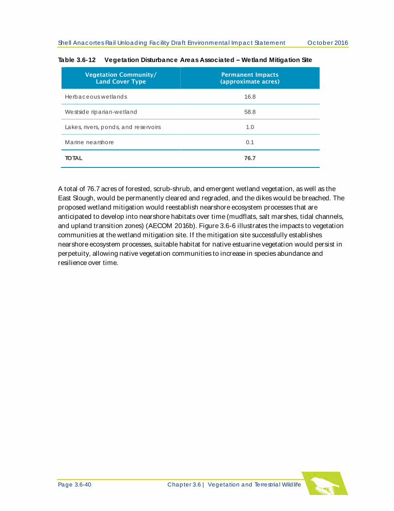
Shell Anacortes Rail Unloading Facility Draft Environmental Impact Statement October 2016
Page 3.6-40 Chapter 3.6 | Vegetation and Terrestrial Wildlife
Table 3.6-12 Vegetation Disturbance Areas Associated – Wetland Mitigation Site
Vegetation Community/
Land Cover Type
Permanent Impacts
(approximate acres)
Herbaceous wetlands 16.8
Westside riparian-wetland 58.8
Lakes, rivers, ponds, and reservoirs 1.0
Marine nearshore 0.1
TOTAL 76.7
A total of 76.7 acres of forested, scrub-shrub, and emergent wetland vegetation, as well as the
East Slough, would be permanently cleared and regraded, and the dikes would be breached. The
proposed wetland mitigation would reestablish nearshore ecosystem processes that are
anticipated to develop into nearshore habitats over time (mudflats, salt marshes, tidal channels,
and upland transition zones) (AECOM 2016b). Figure 3.6-6 illustrates the impacts to vegetation
communities at the wetland mitigation site. If the mitigation site successfully establishes
nearshore ecosystem processes, suitable habitat for native estuarine vegetation would persist in
perpetuity, allowing native vegetation communities to increase in species abundance and
resilience over time.
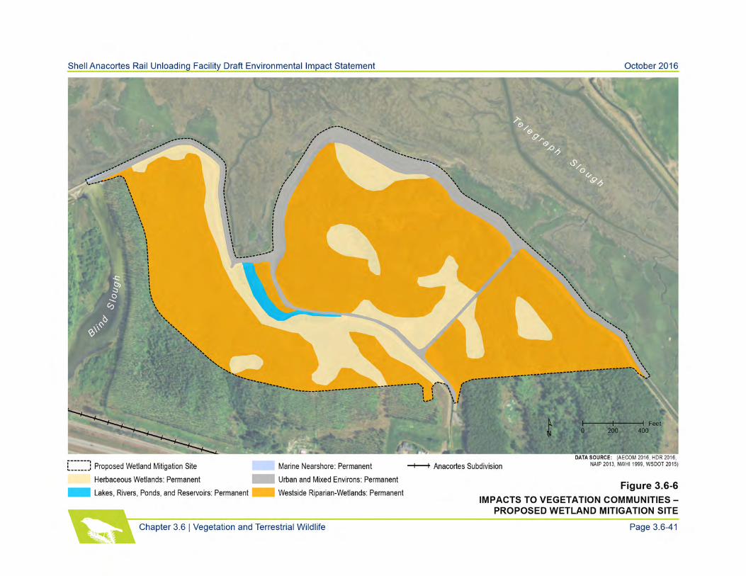
Shell Anacortes Rail Unloading Facility Draft Environmental Impact Statement October 2016
Page 3.6-42 Chapter 3.6 | Vegetation and Terrestrial Wildlife
Operation
Operation and maintenance would be designed to meet the goals and objectives of the wetland
mitigation site, which are to restore nearshore habitats and establish upland vegetation on the
new setback dike. After grading is completed, disturbed areas would be revegetated with native
species. The site would be monitored for plant species cover and vigor, species diversity, and
invasive species. Therefore, if successful, beneficial impacts associated with the operation of the
wetland mitigation site would be significant because the site would increase the extent,
connectivity, and integrity of native vegetation communities and land cover in the watershed.
Direct Impacts to Wildlife
Construction
Construction of the proposed mitigation site would permanently remove the active bald eagle
nest discovered on the site this year. Shell would mitigate for this loss through design and
development of two new bald eagle nesting platforms, which are expected to maintain or increase
overall nesting opportunities on the project site. No significant impacts to other special-status
species are anticipated as there is no breeding or other core habitat for any other species on the
mitigation site. Special-status species such as herons that may forage on the site would be able to
avoid the area during construction.
Construction impacts to nonsensitive wildlife species are anticipated to be similar to the
proposed project site. These impacts are not expected to be significant. Although activities would
likely result in individual animal mortality and permanent loss of deciduous forest habitat used
by certain species for breeding, the impacts are not expected to adversely affect the overall
viability of local populations of nonsensitive wildlife species.
Operation
Following construction of the wetland mitigation site, beneficial impacts associated with its
operation could be significant for species dependent on nearshore habitats for life history stages,
such as shorebirds and waterfowl.
Indirect Impacts
Over time, the wetland mitigation site is anticipated to reestablish nearshore habitat that could
be used by bird species found in Padilla Bay. Some bald eagle perch trees would be lost and there
may be temporary disturbance to nearshore habitat used by herons for foraging. However,
successful implementation of the mitigation plan would increase food sources for both species in
perpetuity because nearshore habitat and access for fish and aquatic species that eagles and
herons prey upon would be re-established. Therefore, an overall net beneficial impact to wildlife
is anticipated with construction and operation of the proposed project
Shell Anacortes Rail Unloading Facility Draft Environmental Impact Statement October 2016
Chapter 3.6 | Vegetation and Terrestrial Wildlife Page 3.6-43
Anacortes Subdivision
Direct Impacts to Vegetation
The proposed project would add, on average, six one-way train trips per week to the Anacortes
Subdivision. Currently approximately two BNSF Railway trains travel daily on the Anacortes
Subdivision to serve the Shell PSR, Tesoro Anacortes Refinery, and other neighboring industries.
There would be no change to ongoing vegetation maintenance along the rail line; therefore, the
additional trains are not expected to affect vegetation. Unit trains entering the Shell PSR would
be unlikely to contribute substantially to the dispersal of noxious weeds because they would not
carry freight that could be a source for invasive plant species. Potential impacts from an
accidental oil spill or explosion are addressed in Chapter 4 – Environmental Health and Risk.
Direct Impacts to Wildlife
The proposed project would add, on average, six one-way train trips per week to the Anacortes
Subdivision rail line. Currently, four freight trains of varying types and lengths operate on an
average day, in both directions, on the Anacortes Subdivision to serve the Shell PSR, Tesoro
Anacortes Refinery, and other neighboring industries. The proposed addition of six trains per
week would travel at speeds consistent with existing trains traveling on the Anacortes
Subdivision.
Wildlife-train collisions are the most common cause of wildlife mortality along railways (Dorsey
et al. 2015). Wildlife-train collisions are more common where higher quality wildlife habitat
adjoins or intersects railways, or where moderate train traffic occurs (Dorsey et al. 2015). Slower-
moving animal species that are unable to flee oncoming trains are more likely to be struck by
trains. Carrion on the railway may attract scavenging mammals and birds that could
subsequently be killed by a train strike.
The proposed additional trains have the potential to contribute a minor increase in wildlife-train
collisions along the Anacortes Subdivision; however, the impacts are not likely to be significant.
The developed landscape surrounding the rail line precludes the presence of higher quality
habitat that may be used by wildlife. In addition, most of the rail line is not obscured by dense
vegetation, which means that wildlife should be able to detect and evade oncoming trains. Noise
from train operations on the Anacortes Subdivision is anticipated to have similar general impacts
to wildlife as those described for the proposed project site. Shorebirds foraging in areas
immediately adjoining the Swinomish Channel swing bridge may temporarily avoid the area
during train operations, but the impact is anticipated to be negligible with no long-term
avoidance or abandonment of nearshore habitat.
Cumulative Impacts
As described above, construction and operation of the proposed project could result in impacts to
vegetation and terrestrial wildlife. Within the study area, there has been significant agricultural,
industrial, commercial, and residential development. It is assumed that with this growth and
construction, vegetation and terrestrial wildlife resources have been affected
Shell Anacortes Rail Unloading Facility Draft Environmental Impact Statement October 2016
Page 3.6-44 Chapter 3.6 | Vegetation and Terrestrial Wildlife
The Tesoro Clean Products Upgrade Project (Tesoro 2015) (see Table 3.0-2 in Chapter 3.0 –
Introduction, for additional project details) is anticipated to have minimal impacts on vegetation
and terrestrial wildlife as the project would be constructed within a previously developed area of
the refinery. The proposed project, and to a minimal extent, the Tesoro project, could contribute
to a cumulative impact on vegetation and terrestrial wildlife. These impacts would be minimized
by construction BMPs and localized to the Tesoro Anacortes Refinery site and the proposed
project and mitigation sites.
MITIGATION MEASURES
Avoidance and Minimization
Shell has incorporated engineering and operational measures into the design of the proposed
project to avoid and minimize vegetation and terrestrial wildlife impacts including:
The North Stormwater Pond would be located away from the mid-peninsula eagle nest that
would be retained.
Most of the fish-accessible mid-to-lower reaches of Stream S, which parallels the existing
BNSF Railway tracks, would be avoided. All of the wooded riparian area and the salt marsh
portion of a Wetland I1 adjacent to Stream S would be avoided.
Retaining walls would be used rather than sloped sides for the bridge on 4th Street to span
the tracks to minimize permanent wetland impacts.
Although not statutorily required, the lights at the proposed facility would be shielded and
directed downward to minimize light pollution that could affect wildlife.
Shell would restrict asphalt cutting near Padilla Bay to occur during low tides (5-foot tidal
elevation or less) to reduce noise disturbance in potential marbled murrelet foraging habitat.
In addition, impacts to vegetation and terrestrial wildlife would be minimized by the
implementation of the BMPs required as part of the NPDES Construction Stormwater Permit,
CWA Section 404 Individual Permit, CWA Section 401 Water Quality Certification, Hydraulic
Project Approval, Skagit County Grading Permit, and Shoreline Substantial Development Permit.
For example, BMPs could include confining construction activities to daylight hours to minimize
potential light and noise impacts to wildlife, implementing stormwater and erosion control
BMPs, and restoring all temporarily disturbed areas with native vegetation appropriate to site
conditions.
Shell Anacortes Rail Unloading Facility Draft Environmental Impact Statement October 2016
Chapter 3.6 | Vegetation and Terrestrial Wildlife Page 3.6-45
Mitigation
Construction of the proposed project would permanently remove two active bald eagle nests: one
near the Anacortes Subdivision in the southern portion of the proposed project site, and a second
found within the wetland mitigation site. In accordance with the conditions of the USFWS bald
eagle take permit, Shell would mitigate for the loss of the bald eagle nests through design and
development of two new bald eagle nesting platforms at least 400 feet from the new rail
unloading facility, and two new bald eagle nesting platforms within the wetland mitigation site.
These platforms are expected to maintain or increase overall nesting opportunities on the project
site and wetland mitigation site. One existing bald eagle nest on the project site would be
retained. Per the permit conditions, Shell would monitor the nest for eagle use during critical
months and report activity to USFWS.

Shell Anacortes Rail Unloading Facility Draft Environmental Impact Statement October 2016
Page 3.6-46 Chapter 3.6 | Vegetation and Terrestrial Wildlife
This page intentionally left blank